supplementary planning document design and … · design and sustainable development planning...
TRANSCRIPT

Design and Sustainable DevelopmentPlanning Guidelines
Adopted - February 2009
Supplementary Planning Document

Design and Sustainable Development Planning Guidelines

Non-Technical Executive Summary i1. Introduction 11.1. Why this document has been produced 11.2. The status of this document 11.3. What this document covers and who it is for 11.4. How this document is structured 21.5. Who to contact for further information 32. Design Policies 42.1. Introduction 42.2. Work in harmony with the site and its surroundings, and the
limitations and opportunities these create 62.3. Involve the right people at the design stage 82.4. Create walkable and accessible neighbourhoods and plan for a thriving
public transport network 102.5. Create and sustain an appropriate mix of uses 132.6. Make efficient use of land 142.7. Create well-defined streets and spaces 162.8. Create active and overlooked public areas and secure private areas 172.9. Maintain and enhance local character 182.10. Create high quality architecture 212.11. Achieve high standards of environmental performance 223. Streets, Paths and Open Spaces 253.1. Things to consider: 253.2. Who do I need to involve? 253.3. What is likely to be the most appropriate form of development? 253.4. How do you reinforce local character and produce an understandable layout? 263.5. What should I do if local character is based on street patterns that
wouldn't be acceptable under these policies? 273.6. How should traffic speeds be managed? 273.7. Should pedestrian and bicycle routes run alongside the street? 283.8. What provision should be made for buses? 293.9. How much public open space will be needed and where should it be located? 293.10. What materials should I use? 303.11. Are there standards for the width or gradient of pavements? 313.12. Should kerbs be used or are shared surface areas acceptable? 323.13. What level and type of lighting should be used? 323.14. How should I include public art? 333.15. Who is responsible for the on-going maintenance of public spaces? 334. Utilities Infrastructure Requirements 344.1. Things to consider: 344.2. Who do I need to involve? 344.3. How do I get connected to an existing utility supply? 344.4. What do I do if electricity lines run over or close to my site? 354.5. How should I deal with surface water drainage? 354.6. What happens if there may be a risk of contamination? 354.7. How can I reduce the amount of water used? 354.8. How can I produce renewable energy? 354.9. Do I need permission to retrofit a renewable energy system to my house? 375. The Plot 385.1. Things to consider: 385.2. Who do I need to involve? 385.3. What land uses are likely to be appropriate in a mixed use area? 385.4. In sub-dividing or amalgamating land into plots, what do I need to consider? 395.5. Is there a minimum plot size? 395.6. Is there a minimum garden size? 39
Contents
Design and Sustainable Development Planning Guidelines

Contents
Design and Sustainable Development Planning Guidelines
5.7. Do I need to say how the boundary will be defined? 405.8. Is there a maximum height for walls or hedges? 406. Parking Provision 416.1. Things to consider 416.2. Who do I need to involve? 416.3. What do I need to consider if providing parking on-street? 416.4. What do I need to consider if providing parking in parking courtyards? 426.5. What do I need to consider if providing parking in-curtilage
(inside the boundaries of a plot)? 437. The Building 447.1. Things to consider: 447.2. Who do I need to involve? 447.3. Are there any limitations on building height? 457.4. Are there any limitations on building width or depth? 457.5. Is there a minimum distance needed between properties? 467.6. How far should the building be set back from the street? 467.7. How can I ensure the design takes advantage of solar gain and
other measures that will naturally reduce its running costs? 477.8. What types of wall are likely to be appropriate? 487.9. What roof forms and materials are likely to be appropriate? 507.10. Should my building have a chimney stack? 517.11. Should my building have an entrance porch? 517.12. Where should doors and windows be placed? 527.13. What types of doors and windows are likely to be appropriate? 527.14. What level and type of architectural detailing is appropriate? 547.15. What scope is there to improve the energy efficiency of a Listed Building? 557.16. Is there any specific guidance for shop fronts or advertisements? 567.17. Can I add security features (lighting, shutters, CCTV)? 587.18. Do I need planning permission to make minor alterations to my house? 587.19. Who is responsible for on-going maintenance? 588. Internal Layout 598.1. Things to consider 598.2. Who do I need to involve? 598.3. Does it matter how I subdivide a house? 598.4. Does it matter how the rooms are distributed? 608.5. What else do I need to consider? 609. Monitoring and Review 609.1. What we will consider 60Appendix 1: Additional Reading 61Appendix 2: The Code for Sustainable Homes and BREEAM 63
Landscape Character AssessmentUrban Character Assessment
These documents form part of the design guidelines, and have been subject to the samelevel of public consultation and adopted by the council, but are published separately.
Accompanying Documents

The local plan for West Dorset encourages highstandards of design in keeping with localcharacter, and promotes more sustainableconstruction methods. It sets out matters thatwill be considered when assessing proposals fordevelopment, but does not go into extensivedetail. So design guidelines have been producedto give greater clarity on how developmentmight meet the requirements in the plan.
The design guidelines were adopted by WestDorset District Council as a SupplementaryPlanning Document on 3 February 2009. Thismeans that the guidance will be a materialconsideration in deciding planning applications.The document contains 10 design policies andexplains how these policies are applied inrelation to different types and scales ofdevelopment. The policies are summarised here:
a) Work in harmony with the site andits surroundings, and the limitationsand opportunities these create - indesigning any new development, weneed to understand the local landform,how the site fits into the streetnetwork, the neighbouring land usesand local features of interest
b) Involve the right people at the designstage - to ensure that the design takesinto account planning issues, problemsand opportunities that neighbours,specialists and other interested partiesmay identify
c) Create places where people can getabout easily without needing to usetheir cars - routes in towns and villagesshould be well-connected and thelayout easy to understand, streets andspaces safe and pleasant, placesdesigned to suit people of all abilities,and public transport planned in advanceto make sure it is likely to be efficientand easy to use
d) Create and sustain an appropriatemix of uses - so that places that peoplego to on a daily or frequent basis areclose to their homes (this goes hand in
hand with the previous policy)
e) Make efficient use of land - weshould avoid creating wasted or leftoverland, and make the best use of the site,particularly in the most accessiblelocations
f) Create well-defined streets andspaces - the relationship betweenbuildings and the way they enclosespace is a major factor in defining thecharacter and feel of the street, and isalso important (together with the nextpolicy) in reducing fear of crime. Weshould also ensure that where parkingis needed, the street's character is notdominated by a wide expanse of tarmacand parked cars
g) Make sure public areas are full ofactivity and overlooked by people inbuildings, and private areas aresecure - designs should ensure thatwindows and doors face onto the streetand other places where surveillance isneeded, and the rear of homes enjoys abasic level of privacy
h) Maintain and enhance local character- the design and materials used in newdevelopment should help maintain orstrengthen the local identity of an area,creating places which people associatewith and have pride in. This doesn'tmean that development should simplycopy what already exists, or that newtechnologies cannot be used.Traditional materials and design ideascan be used in a totally modern way,new materials and technologies can beused to create places and reflecttraditional styles
i) Create high quality architecture -consider the symmetry within thedesign, the distribution andproportioning of doors and windows,the richness of detail and quality ofmaterials used
iDesign and Sustainable Development Planning Guidelines
Non-Technical Executive Summary
ii
j) Achieve high standards ofenvironmental performance -buildings and spaces should bedesigned to last. Construction materialsand techniques should not causesignificant harm to the environmentand should make efficient and prudentuse of resources. Renewable sourcesshould be used to harness carbon andwater savings where practical.
Character assessments have been produced.These set out clearly the key characteristics thatgive an area its individuality. These include:
Appraisals or studies of the mainConservation Areas, completed for theoldest and most historic parts of manytowns and villages in West Dorset,helping us understand the specialcharacter of these places and ensure thatdevelopment either preserves orenhances that character
Urban character assessments of the maintowns, identifying what makes themdifferent. These also focus on the areasnot included in the above appraisals.They list features that make peoplerelate positively to a place. This shouldmean that when building works takeplace, it is done in a manner thatreinforces local character in a good way,even if the area isn't of historic interest
An assessment of the landscapecharacter of the district. This recognisesthat the landscape of West Dorset is veryvaried. It is a working and livinglandscape with mixed farmland and arich history. Each area is described interms of its characteristic features, andalso what changes have taken place thathave detracted from the underlyingcharacter. This will be useful in assessingwhether and how a design would fitwithin an area, and what landscapetreatment may be appropriate.
The district council is keen to encourageprotection of the environment and ensure the
efficient use of resources, for today and forgenerations to come. Because some developershave told us that they are unsure how toimprove their designs to meet higher standardsin a cost-effective way, the council has providedinformation sheets on various technologies thatare currently available. These include:
Insulation & air-tightnessLow energy ventilationThermal massCombined heat & powerEnergy efficient appliancesGlazing, orientation & solar gainSolar hot waterSolar photovoltaicsWind powerHeat pumpsBiomass (such as wood chip boilers)Community heating systemsBiofuels & biogasRain water harvestingGrey water recycling (such as waterfrom washing machines)Water efficient devicesGreen roofs covered with livingvegetationLifetime homes which are easilyadaptable to someone's needsthroughout their life
Although the council was keen to specify aminimum code for sustainable homes standardfor all new homes, the Government has said thatthis should not normally be done by localcouncils as such advances will be brought inthrough changes to the building regulations. Wewill monitor how much these technologies areintroduced in new development, and continue towork with developers to find practical solutionsto any planning issues.
It is hoped that these design guidelines, togetherwith the supporting documents, will be effectivein encouraging high standards of design inkeeping with local character, and promotingmore sustainable construction methods.
Non-Technical Executive Summary
Design and Sustainable Development Planning Guidelines
1.1. Why this document has beenproduced
1.1.1. The local plan for West Dorset encourageshigh standards of design in keeping withlocal character, and promotes moresustainable construction methods. It setsout matters that will be considered whenassessing proposals for development, butdoes not go into extensive detail. Sothese design guidelines have beenproduced to give greater clarity on howdevelopment might meet therequirements in the plan.
1.2. The status of this document
1.2.1. This document was adopted by WestDorset District Council as aSupplementary Planning Document on 3February 2009. This means that it will bea material consideration in decidingplanning applications. The importancegiven to it when making planningdecisions will reflect the fact that it hasbeen subject to considerable publicconsultation as well as a sustainabilityappraisal process.
1.2.2. It should be noted that the policiescontained in this document do notoverride national planning guidance, theregional spatial strategy or adopteddevelopment plan documents. Thisdocument does not override the need toconsider other regulations such as theHabitats Regulations that protect sites ofEuropean nature conservation importance.
1.3. What this document covers and whoit is for
1.3.1. This document covers a wide range ofdesign issues and possible solutions. Weall know that a solution that works well interms of one objective, such asmaximising its sustainability, may notnecessarily work well in terms of anotherobjective, such as strengthening localcharacter. The type of scheme, itslocation and its proposed use will all have
a bearing on what works and whatdoesn't. Guidance in this document isintended to apply to all types of builtdevelopment in towns, villages and themore rural parts of West Dorset. Wherethe principles would not be appropriatefor a certain type of development (forexample, large industrial units) or is onlyrelevant to the more built-up, urbanareas, this is made clear in the policy oraccompanying text.
1.3.2. The aim of these guidelines is to set outclear, simple and consistent advice so thatthose involved in development know whatthe council, as planning authority, willinsist on in terms of design andsustainable construction, prior to givingplanning consent.
1.3.3. The planning and building processinvolves or impacts upon a wide range ofpeople including planning officers,designers, engineers, developers, buildersand contractors, the owner and end users,as well as the wider community. All havea part to play in ensuring thatdevelopments are designed, built andfunction, and may use this document tohelp guide their actions. The roles ofsome of those involved in the planningand building process in ensuring gooddesign are set out below in more detail inthe following table.
1
1. Introduction
Design and Sustainable Development Planning Guidelines
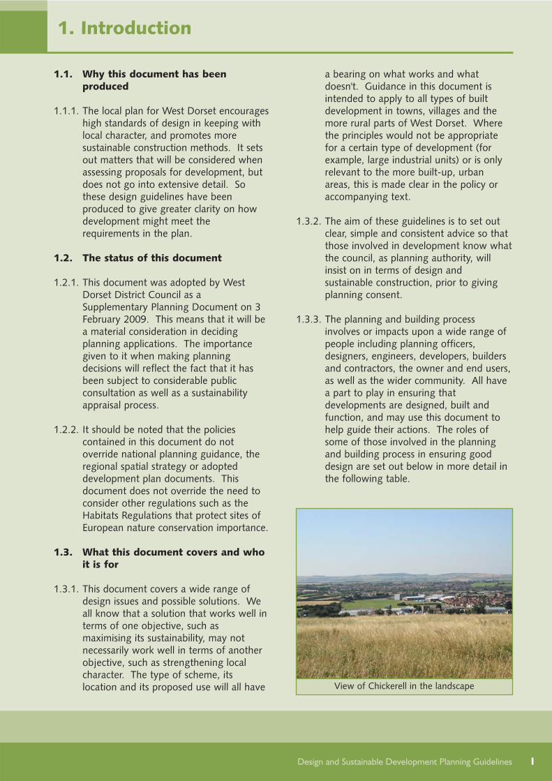
View of Chickerell in the landscape

2
1.4. How this document is structured
1.4.1. Chapter 2 sets out the broad principlesand policies for development, in relationto design and sustainable development.The remaining chapters 3 to 8 considerthe different built elements, from thelarge scale decisions (such as the roadlayout) down to the detailed decisions(such as the type of windows used). Eachchapter answers commonly askedquestions, and aims to highlight wherethere may be conflicts and what solutionsare likely to be acceptable. Chapterscover the following built elements:
Streets, paths and open spaces - thepattern of the streets, trafficmanagement, pavements, surfacetreatment, lighting and public art
Infrastructure needed for utility services
- connections, drainage, contaminatedland, water and electricity generation(including renewable energy)
The plot - size and shape, extent ofgardens, and the treatment of theboundary
Parking provision - on-street, inparking courtyards or on the plot
The building - size, orientation anddistance from the road plus detaileddesign, materials and security measures
Internal layout and fittings -subdivision and distribution of rooms.
1.4.2. The final chapter sets out how thisdocument will be kept under review.
1.4.3. To help set out clearly the keycharacteristics that give an area itsindividuality, character assessments have
1. Introduction
Design and Sustainable Development Planning Guidelines
Local planning authorityWest Dorset District Council, as the local planning authority, is committed to securing high qualitydesign in new developments, through effective planning policy, early discussion with the owner ordeveloper and other interested parties, and clear and consistent development control decisions.Planning staff try to work closely with the other divisions, such as building control, and with thecounty council on roads and other transport issues, and representatives of the local community, tohelp ensure that the resulting development looks good, functions well and meets local needs.
Owner or developerSuccess must start with the person initiating the project (the developer), which may either be a housebuilding or commercial development company, or, in the case of extensions or alterations to a home,the owner or occupier. It is important that owners and developers are aware of the benefits of gooddesign, both in terms of creating a more positive environment and potential long-term rewards. Forexample, many energy-efficient features are much more economical to include in the initial building(as opposed to retro-fitting later), will pay-back through reduced running costs and add to the resalevalue of a property.
Designers, architects and engineersDesigners are responsible for creating environments for people to use and enjoy. Architects, urbandesigners, artists, landscape architects and engineers are highly trained and can all bring a range ofpositive ideas that together can inspire great designs and new ways of working.
Builders and contractorsBuilders and contractors are responsible for turning designs into reality. The application of skills andspecialist knowledge required can make an enormous difference to the quality of the finishedbuilding.
been produced that go with this planningguidance. These are:
Conservation Area appraisals,completed for the oldest and mosthistoric parts of many towns andvillages in West Dorset, helping usunderstand the special character ofthese places and ensure thatdevelopment either preserves orenhances that character
Urban character assessments, whichlook at the character of the mainsettlements outside the conservationareas and identify the local featuresand landmarks plus the type of streetsand local buildings that characterise aplace.
Landscape character assessments,which identify the local landscapetypes, and within each type, individualcharacter areas. These describe thecharacteristic features of each areaand what recent changes may haveundermined this.
1.4.4. There are also sustainable technologyinformation sheets, which provideinformation on a range of technologies,including their effectiveness, costs,suitability and current levels of use.
1.4.5 Guidance on what information to submitwith a planning application is alsoprovided and will be kept under review.
1.5. Who to contact for furtherinformation
1.5.1. To find out more about planning policy, orto have your details added to (or removedfrom) our consultation database, pleasecontact the planning policy division at theaddress below:
Planning Policy DivisionWest Dorset District CouncilStratton House58-60 High West StreetDorchesterDorset DT1 1UZ
Tel: 01305 252386Fax: 01305 251481Email: [email protected]
If it would be helpful to get thisinformation in a different format, you canrequest it free in:
large printbrailleaudio CDaudio cassetteEasy Read
A summary of this policy document canbe translated or interpreted into anotherlanguage
This document and non-technicalsummary can also be downloaded fromwww.dorsetforyou.com/designguidelines/west
To request a copy contact: Equality and Community DevelopmentOfficer, West Dorset District CouncilTel: 01305 251010Email: [email protected] calls welcome
3
1. Introduction
Design and Sustainable Development Planning Guidelines
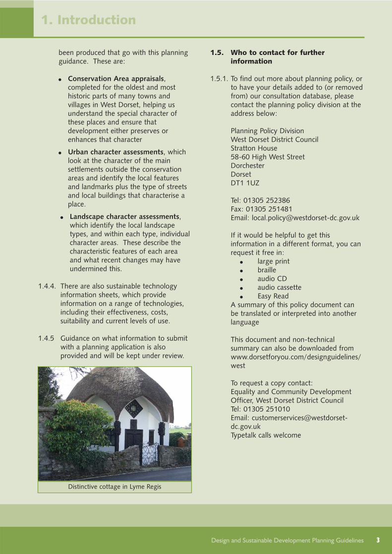
Distinctive cottage in Lyme Regis

4
2. Design Policies
Design and Sustainable Development Planning Guidelines
1 Policy E, Draft Revised Regional Spatial Strategy For The South West, 2008, GOSW2 Para. 33, PPS1: Delivering Sustainable Development, 2005, ODPM (now DCLG)3 Para. 1, PPS7: Sustainable Development in Rural Areas, 2004, ODPM (now DCLG)4 definition drawn up by the World Commission on Environment and Development in 1987, which was reaffirmed in the UK
Government's 2005 strategy, Securing the future - delivering UK sustainable development strategy, The UK Government SustainableDevelopment Strategy. Cm 6467 HM Government, March 2005
5 based primarily on para 36, PPS1: Delivering Sustainable Development, 2005, ODPM (now DCLG) and acknowledged best practice
2.1.1. There is general agreement that gooddesign and sustainable developmentshould go hand in hand, and should beapplied whatever the type or scale ofbuilding works proposed.
"All development should deliver thehighest possible standards of design,both in terms of urban form andsustainability criteria"1
2.1.2. Everyone can play a role in ensuring thatgood design and sustainable developmentare achieved, including the developmentindustry that designs and constructsbuildings, the council and others whoconsider or comment on the proposals,and the existing or future occupants whoneed and will use the development.
2.1.3. But what is good design?
"Good design ensures attractive,usable, durable and adaptable placesand is a key element in achievingsustainable development"2
"All development in rural areas shouldbe well designed and inclusive, inkeeping and scale with its location,and sensitive to the character of thecountryside and local distinctiveness."3
2.1.4. And what is the goal of sustainabledevelopment?
"to enable all people throughout theworld to satisfy their basic needs andenjoy a better quality of life, withoutcompromising the quality of life offuture generations"4
2.1.5. To help clarify what is meant by gooddesign and sustainable development, theprinciples5 opposite have been pulledtogether, and form the basis of the designpolicies outlined in this chapter.
2.1.6. These objectives are reflected in thecouncil's adopted planning policies andmore recent national policy. The first twoobjectives (A and B) relate to goodplanning practice, the need to understandthe site and the issues that may be raisedin relation to any development, and arerelevant for all types and scales ofdevelopment. The following two (C andD) relate mostly to large-scaledevelopments or changes that will affecthow a neighbourhood functions.Objectives E to G consider how buildingsaffect surrounding spaces, and how thosespaces can function most effectively. Thefinal three policies (H to J) focus on themore detailed design and sustainability ofbuilt development, and are most relevantto householders considering changes totheir properties as well as beingapplicable at larger scales. The followingpolicies provide more detailed guidanceon these objectives and how proposalsfor development will be assessed.
2.1. INTRODUCTION
New development in West Bay
5
2. Design Policies
Design and Sustainable Development Planning Guidelines
Development should:
a) Work in harmony with the site and its surroundings and thelimitations and opportunities these create - understand the locallandform, how the site fits into the street network, the neighbouring landuses and local features of interest
b) Involve the right people at the design stage - to ensure that thedesign takes into account planning issues, problems and opportunitiesthey may identify
c) Create walkable and accessible neighbourhoods and plan for athriving public transport network - routes in towns and villages shouldbe well-connected, streets and spaces safe, pleasant and easy to use
d) Create and sustain an appropriate mix of uses - so that places thatpeople go to on a daily or frequent basis are in a reasonable walkingdistance of their homes
e) Make efficient use of land - avoid creating wasted or leftover land, andoptimise the potential of the site, particularly in the most accessiblelocations
f) Create well-defined streets and spaces - the relationship betweenbuildings and the way they enclose space is a major factor in defining thecharacter and feel of the street, and should not be dominated by a wideexpanse of tarmac and parked cars
g) Create active and overlooked public areas and secure private areas -windows and doors should face onto the street and other places wheresurveillance is needed, and the rear of homes should enjoy a basic levelof privacy
h) Maintain and enhance local character - the design and materials usedin new development should help maintain or strengthen the local identityof an area, creating places which people associate with and have pride in
i) Create high quality architecture - consider the symmetry within thedesign, the distribution and proportioning of doors and windows, therichness of detail and quality of materials used
j) Achieve high standards of environmental performance - buildings andspaces should be durable and adaptable, construction materials andtechniques should not cause significant harm to the environment, andshould make efficient and prudent use of resources. Renewable sourcesshould be used where practical to harness carbon and water savings.

6
2.2.1. No two sites are the same as each other.Very few are flat and featureless.Understanding the site and how it relatesto the wider area is essential to ensuringthat development can reinforce a senseof local identity, has good access to thelocal area, and does not adversely impacton neighbouring uses. Carrying outappropriate checks or surveys at an earlystage can help ensure that features ofinterest can be successfully identified andwhere possible, incorporated into thedesign of the new development.
2.2.2. The council's policies and allocations aimto direct development away from sitesthat are prone to flooding or landinstability, may be contaminated orparticularly susceptible to contamination,or prone to unpleasant microclimaticeffects such as high levels of wind speedand frost pockets. Areas where there arestrategically significant features that arelikely to limit development potential (suchas the flood plains associated with themain rivers and sites of known natureconservation importance) are shown onthe council's proposals map6.
2.2.3. There may also be local features thatshould be retained because of theircontribution to the local character of thearea or other benefits that they provide.The importance given to keeping themwill depend on the nature of their
interest, and how much they are part ofthe street scene or can be seen from awider area. In certain circumstances, itmay be appropriate to considerintroducing new features (see also section[2.9]).
2.2.4. A site assessment should be submittedwith most planning applications (as partof the design and access statement),identifying the various constraints andopportunities for that site, and how thesehave influenced the design. This mayinclude information on:
The local landform (both in terms oftopography and potential geologicalhazards such as landslips, subsidenceor fault movements) and knownmicroclimatic (weather) factors thatmay influence how the buildings orspaces function
Opportunities to connect into theexisting route network, forpedestrians, cyclists and motorisedtraffic7
Existing features that are either locallysignificant or important for localcharacter (including ecological,geological or historic interest)8
Opportunities to build in beneficialbiodiversity (plant and wildlife) orgeological features. This can includesmall actions, such as including bird
2. Design Policies
Design and Sustainable Development Planning Guidelines
6 The extent of these areas may be reviewed by the designating body (such as the Environment Agency, English Heritage andNatural England) and therefore developers are advised to check with the council if they are unsure whether a site'sdevelopment potential may be affected.
7 Advice on connections into the existing route network can be obtained from the highway authority (normally the countycouncil).
8 Possible features could include significant trees or hedgerows, ancient woodlands, native wildflower verges, significant birdcolonies, bat and barn owl roosts, and the presence of other protected or locally significant species (that may notnecessarily be protected in their own right), ponds, streams or rivers, other boundary markings, features of archaeologicalinterest, Listed Buildings and other buildings and features of local historical interest, historic parks or gardens etc.Information on local character is provided in the relevant landscape character and urban character and conservation areaassessments - see section [2.9]
2.2. WORK IN HARMONY WITH THE SITE AND ITS SURROUNDINGS,AND THE LIMITATIONS AND OPPORTUNITIES THESE CREATE

and bat boxes on buildings, to largerscale actions such as providing spacesfor wildlife to go through adevelopment linking to thecountryside beyond9
Opportunities to enhance the naturalbeauty of the area10
What the neighbouring land is usedfor, the likely level of activity and noiseand proximity to people's homes.These need to be considered to ensurepeople's enjoyment of their ownhomes is not unduly affected11
7
2. Design Policies
Design and Sustainable Development Planning Guidelines
Design Policy A: Work in harmony with the site and its surroundings, and the limitationsand opportunities these create Development should respect and work in harmony with:
the local landform and microclimatethe existing route networkexisting features that are locally significant or important for local character, historical, ecological or geological reasonsneighbouring land uses.
Opportunities to incorporate features that would enhance local character, or the historical, ecologicalor geological interest of a site, should be taken if practical and appropriate.
9 as set out in national guidance para 14, PPS9: Biodiversity and Geological Conservation, 2005, DCLG10 Section 85 of the Countryside and Rights of Way Act 2000 requires local authorities in exercising their development control
functions in the Dorset Area of Outstanding Natural Beauty, to have regard to the purpose of conserving and enhancingthe natural beauty of the area.
11 Advice on noise and disturbance, pollution, as well as daylight standards, can be obtained from the district council'sEnvironmental Health division
Typical site assessment
Consider the wider context

8
2.3.1. It is important in designing any newdevelopment to understand and take onboard the thoughts of those who may beaffected by it. It is also important tounderstand what utility services and otherinfrastructure requirements (such asroads) will be needed, to plan for theseand integrate them into the design tobest effect. Involving the right people atan early stage will save unnecessary timebeing spent pursuing schemes that haveinsurmountable objections, and maypotentially achieve a greater degree ofsupport for a project. It may also showopportunities to improve a scheme, whichmay otherwise be overlooked or gounnoticed until much later in the process.
2.3.2. Who and how you consult will dependupon the type and scale of thedevelopment proposed. Householdextensions and alterations will normallyonly affect the immediate neighbours.Larger schemes will potentially affectmany local residents, businesses andvisitors to the area. There may beorganised, representative groups that canbe involved as part of your consultation,and the local area partnership can helpput you in touch with these12. There isalso a wide range of local groups andorganisations with expert knowledge thatcan be tapped. Elected representatives(the town or parish council, as well as thedistrict and county councillors for thearea) may be able to raise local issues.
However due to their involvement inmaking decisions on planningapplications, councillors may be limited inwhat they can say13.
2.3.3. Liaison with building regulations advisorsand disabled representatives14 should takeplace to ensure that any proposals willmeet current regulations and bestpractice. Because there will generally bea need for drainage for all new buildings,and such systems require maintenance,these should be discussed with theTechnical Services Division of the districtcouncil before an application issubmitted. The Dorset PoliceArchitectural Liaison Officer should alsobe involved at an early stage if there arecrime or safety concerns15.
2.3.4. On larger schemes, liaison with officersresponsible for highways and wastecollection is advisable with the provisionof all new roads. Public transportoperators should be involved in schemeswhere new bus routes are likely to beneeded. Where development will createnew public spaces, liaison with theorganisations responsible for the overalllandscape design and the various items ofstreet furniture is advisable. Artists canusefully be involved in the early stages ofthe design of the development.Consultation can be more valuable ifcreative ways are used. One example ofthis is to employ artists to run workshops
2. Design Policies
Design and Sustainable Development Planning Guidelines
12 The West Dorset Partnership Officer at the council can provide relevant contact details, or visithttp://www.dorsetforyou.com/index.jsp?articleid=1833
13 Due to the need to avoid pre-determination at a later stage in the planning process, councillors may not be able to providedefinitive views at pre-application stage (if such views would give the impression that a later response would not be madewith an open mind). However, by keeping them informed they can help raise local issues and better represent localinterests. The Members Services Officer at the council can provide relevant contact details, or visithttp://dorsetforyou.com/index.jsp?articleid=384497
14 Such as representative groups linking to the Local Area Partnerships, or Dorset County Council Adult Services, who employsstate registered occupational therapists that have regular involvement in the elderly population and a good backgroundknowledge in a variety of disabling conditions and the impact it has on their lifestyle.
15 Section 17 of the Crime and Disorder Act places a statutory duty on police and local authorities to work in partnership totackle problems in their area.
2.3. INVOLVE THE RIGHT PEOPLE AT THE DESIGN STAGE

with communities. On particularlysignificant or sensitive schemes,organisations which have to be consultedby law, such as Natural England, EnglishHeritage and the Environment Agency,may be able to provide advice on issuesrelevant to them before a planningapplication is submitted.
2.3.5. It is the owner's or developer'sresponsibility to decide on how suchconsultation will be carried out, and tomake the proposed arrangements. Astatement setting out who was consulted,showing the findings and how these haveinfluenced the design, should besubmitted with most applications. Thecouncil will produce an advice note fordevelopers on how to carry outconsultation with the local communityand relevant specialists on major orpotentially significant developmentsbefore a planning application is made.
9
2. Design Policies
Design and Sustainable Development Planning Guidelines
Design Policy B: Involve the right people at the design stageThe council encourages owners and developers to engage in early discussions with adjoiningresidents, service providers and other groups likely to be affected by, comment on, or have creativeideas about the development, to ensure the design takes into account planning issues, problems andopportunities that these groups may identify.
Different consultation techniques
Keep a record of what was said

10
2.4.1. Developments that promote lifestyleswhich are not reliant on the car, andprovide natural opportunities for healthyrecreation and social interaction, go someway towards creating better places thatwill not harm the environment in thelonger term. This can be achieved byplanning for a thriving public transportnetwork and developing walkableneighbourhoods in the towns and villagesof West Dorset, and taking intoconsideration development that is likelyto come forward in the future.
2.4.2. A walkable and accessible neighbourhoodis where:
places that people go to on a daily orfrequent basis are in walking distanceof their homes
the layout is permeable (routes arewell-connected)
the layout is legible (easilyunderstood), and everyday facilitiesused by a community, and buildingsthat serve other important publicfunctions (such as law courts andcouncil offices), are easy to find
streets and spaces are safe andpleasant to use, with the emphasisplaced on inclusive design andconsidering pedestrians first
2.4.3. Access to everyday facilities is important,and at a strategic level, the council'spolicies and allocations aim to direct newdevelopment to the larger settlementswhich have a broad range of services.The need to encourage mixed useneighbourhoods is also well supportednationally16 (further guidance is given insection [2.5]).
2. Design Policies
Design and Sustainable Development Planning Guidelines
16 para 36 PPS1: "Planning authorities should prepare robust policies on design and access... Key objectives should includeensuring that developments … create and sustain an appropriate mix of uses (including incorporation of green and otherpublic space as part of developments) and support local facilities and transport networks."
2.4. CREATE WALKABLE AND ACCESSIBLE NEIGHBOURHOODS ANDPLAN FOR A THRIVING PUBLIC TRANSPORT NETWORK
Consider where links are needed
Identify where bus stops should be
Streets and spaces should be safe and pleasant

2.4.4. In towns and villages, the design ofstreets and spaces, use of landmarkbuildings and other landmark features(such as a village green, a traditional redtelephone kiosk, a pond, or a visuallyprominent tree), and views to andbetween these features, should all beused to make it easier for people tounderstand the layout and find their wayabout. The road and pavement widthsshould reflect the likely levels of vehicularand pedestrian traffic, providing anunderstandable hierarchy within anoverall network providing this doesn’tundermine the historical significance ofthe route (see section [2.9]. Theperimeter block (where buildings arelocated on all sides of a block, eachfacing onto the street, with privategardens meeting in the centre) is a triedand tested structure for providing apermeable, convenient and well-connected layout, whilst achieving theother objectives of good design. Furtherguidance is given in section [3].
2.4.5. To ensure streets and spaces are safe andpleasant to use, consideration needs tobe given to the needs of all users, trafficspeeds, pedestrian and cyclists’ safety,fear of crime and localised problemscaused by the climate (such as wind andshading). By law17, design should ensurethat disabled people have reasonableaccess to facilities, services andpremises18, and further guidance is givenon appropriate pavement design,including widths and gradients (seesection [3.11]). The positioning ofbuildings as well as the design of theroad layout can be used to manage trafficspeeds. Development should avoidcreating places in built-up areas whereroutes are not well used or overlooked,and have potential 'hiding places' wherepeople may feel unsafe and criminals may
operate undetected (see section [2.8]).Any potential microclimatic effects, suchas wind tunnels and shade, should becarefully considered and adverse effectsreduced in the design.
2.4.6. Buses are likely to be the most practicalsolution for providing public transport inWest Dorset. Local streets likely to beused by buses should be identified in thedesign process, working in partnershipwith public transport operators. Thisshould ensure that the streets canaccommodate the size of vehicles likely tobe used, that stopping places can beprovided (even if they are notimmediately built or used), and that theroutes are likely to be attractive to usersand operators. In areas close to anexisting railway station, access to thestation (both on foot and by bus) shouldbe safeguarded.
11
2. Design Policies
Design and Sustainable Development Planning Guidelines
17 Part III of the Disability Discrimination Act 1995A minimum standard is set in building regulations: Approved Document M - Access to and Use of Buildings, 2004, OPDM
18 http://www.planningportal.gov.uk/england/professionals/en/1115314110382.html
Consider first
Consider last
PedestriansCyclistsPublic transport usersSpecialist service vehicles(e.g. emergency services,waste, etc.)Other motor traffic
Consider pedestrians and cyclists first

12
2.4.7. In rural areas, changes to existing or theprovision of new routes will normally beundertaken by Dorset County Counciland therefore will be guided by theprinciples adopted in the Dorset RuralRoads Protocol. The aim of the protocolis:
To balance the safety and access needsof users with care for the environmentand the quality of our landscape andsettlements
To use local materials and designschemes to be sympathetic to thecharacter of our rural settlements
To consider the landscape near theroad and address the needs of thenatural environment plus local heritage
To encourage sustainability andconsider the potential impacts ofclimate change, ensuring that ruralroads do not create or contribute toforeseeable environmental problems inthe future
To keep signs, lines and streetfurniture to the minimum needed for
safety and remove intrusive roadsideclutter. Where signs and markings areneeded, to adapt standard designswherever possible to make them thebest possible fit with localsurroundings.
2. Design Policies
Design and Sustainable Development Planning Guidelines
Design Policy C: Create walkable and accessible neighbourhoods and plan for a thrivingpublic transport networkWithin settlements, the design of streets should be permeable, and respect opportunities for futuregrowth. In residential areas, or where pedestrian activity is high, the design should aim to keep trafficspeed below 20mph. Bus routes and stops, and strategic cycle and pedestrian routes, should be planned for (even if theyare not immediately used or built), including possible future connections to adjoiningneighbourhoods.The design of public outdoor spaces (where walking or recreation is encouraged) should minimiseunpleasant microclimatic effects, cater for the needs of disabled people, and be appropriately lit andoverlooked to reduce the fear and incidence of crime. Within settlements, the design of development should be legible, and this can be achieved throughensuring:
Routes are designed to reflect the likely levels of vehicular, cycle and pedestrian traffic, withinan understandable hierarchy in the overall network. Key routes should broadly follow desirelines where this is practical, and any significant changes in direction should be marked bystopping places or landmarksStopping places are included at key points on the route network, and views to thesesafeguardedLandmark buildings and features are included at key points, buildings reflect the type of use oractivity proposed, and views to landmarks are safeguarded.
Avoid signage clutter

2.5.1. The provision of a range of facilities andemployment areas together with newhousing will help to increase the level ofself-containment, reduce the need forcar-based travel, and enhance the vitality,viability and sustainability of that area inthe long term. Planning should aim toensure that places people go to often(such as their place of work, local shops,school and doctor's surgery, recreationspaces, community hall and publictransport) are in a reasonable walkingdistance of their homes. Meeting places,community facilities and uses thatgenerate a lot of local activity or have ahigh public profile, can help provide afocal point in a development, andstrengthen a place's identity. A mix ofopen spaces can also support a greatermix of plants and wildlife and providerecreational and other benefits.
2.5.2. In deciding what level of mixed use isappropriate, the level of developmentand its context should be considered. Forexample, in a large urban extension, itwould normally be necessary to include awide range of different uses to ensure areasonable level of self-containment. Onsmall schemes the proximity of, andpotential impact on, existing facilities willbe the main consideration. Uses that willgenerate a reasonably high degree ofpedestrian activity should normally beclustered together in local centres toensure that trips can be shared and publictransport works well. The followingfactors will also relevant:
The scale and design requirements ofthe proposed uses and whether thesewould adversely affect local character
The potential noise and disturbanceand whether this would adverselyaffect neighbouring uses
The likely generation of trips by carand other vehicle movements, andwhether these can be accommodatedwithout harm
Wider potential impacts, for exampleon wildlife, protected habitats orhuman health.
Further guidance on appropriate uses isgiven in section [5.3].
2.5.3. In planning larger scale developments (inthe region of 100 or more homes or sitesof over 2.5ha) the council will normallywork in collaboration with the developer(if known) and the local community toproduce a detailed development brief ormasterplan for the site.
13
2. Design Policies
Design and Sustainable Development Planning Guidelines
Design Policy D: Create and sustain an appropriate mix of usesProposals for development of new buildings or change of use within settlements should, wherepractical, contribute towards an appropriate mix of uses, aimed at increasing the level of self-containment and reducing the need for car-based travel, through a balance of homes, open spaces,local services, community facilities and employment workspace.In this mix, uses that will generate a comparatively high degree of pedestrian activity should normallybe clustered together to ensure that trips can be shared and public transport can be effectivelyrouted.
2.5. CREATE AND SUSTAIN AN APPROPRIATE MIX OF USES
Compatible mix of uses at Poundbury

14
2.6.1. The most efficient use of land is achievedthrough higher density, mixed usedevelopments. The regional spatialstrategy19 says that councils should aim toachieve a target net density of 40dwellings per hectare (averaged across allnew housing in their local area), withhigher densities in the most accessiblelocations20. Densities below 30 dwellingsper hectare are not acceptable unlesslocal character, lack of infrastructure orpoor accessibility of a location justifiesotherwise. The route network, size andshape of plots, and use of outside space,will all have a bearing on the density ofdevelopment.
2.6.2. Well-defined streets and spaces within aperimeter block layout21 tend to make themost efficient use of land in built-upareas. Distributor or service roads androad layouts that need large turning areasare less efficient and unlikely to producea reasonable degree of enclosure.
2.6.3. The subdivision of plots may beinefficient if it results in areas that aredifficult to develop, for example becauseof proximity to adjoining buildings orother limitations, and when the leftoverspace has no intrinsic value.
2.6.4. The creative use of outside spaces in andadjoining settlements can help achievethe most efficient use of land. Forexample, there may also be opportunitiesto combine:
Leisure and recreation (for example,through the inclusion of seating,shelter or play equipment, which mayhelp form a focal point in thedevelopment)22
Sustainable drainage to help deal withsurface water drainage and alleviateflooding (for example, through theextent and permeability of surfacetreatments, and the use of retentionponds and wetlands)
Wildlife and plant support
Landscape solutions that will helpsoften the impact of newdevelopment, which may otherwisefor example be dominated by tarmac(this could be the inclusion of streettrees or verges, planting strips as partof a landscape scheme).
How the space between buildings isshared between the carriageway, any on-street parking, pavement, grass verge,public open space and private frontgarden, will also have a bearing on localcharacter (see section [2.9]), overlookingand privacy (section [2.8]), and theservicing arrangements for the building(section [7.6]). The design of publicspaces must work with the rest of thedevelopment's overall design to helpachieve the most efficient use of land andmeet the other policies in this guidance.
2.6.5. On sites where there is a lot of publicopen space planned, the council willrequire a strategy to be submitted settingout how the open space will be designed,how the spaces will function (particularlyin terms of public access, recreation,surface water drainage and inclusion ofbiodiversity and other local features), andtheir future management andmaintenance.
2. Design Policies
Design and Sustainable Development Planning Guidelines
19 Policy H220 para 47, PPS3: Housing, 2006, DCLG21 where buildings are located on all sides of a block, each facing onto the street, with private gardens meeting in the centre22 Targets for public open space provision of various types, based on a recent assessment of current provision and need, will
be set in the Planning Obligations guidelines in 2009
2.6. MAKE EFFICIENT USE OF LAND
15
2. Design Policies
Design and Sustainable Development Planning Guidelines
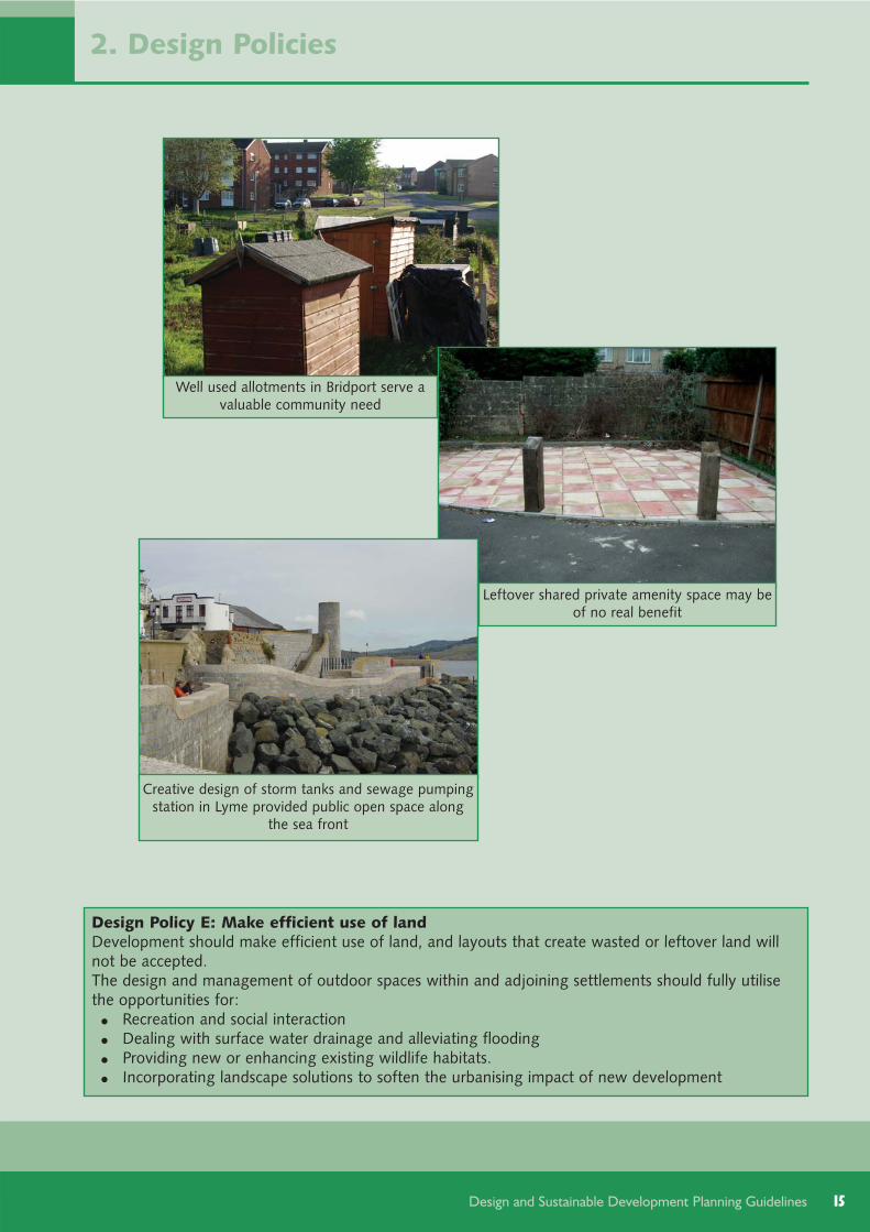
Design Policy E: Make efficient use of landDevelopment should make efficient use of land, and layouts that create wasted or leftover land willnot be accepted.The design and management of outdoor spaces within and adjoining settlements should fully utilisethe opportunities for:
Recreation and social interactionDealing with surface water drainage and alleviating flooding Providing new or enhancing existing wildlife habitats. Incorporating landscape solutions to soften the urbanising impact of new development
Well used allotments in Bridport serve avaluable community need
Leftover shared private amenity space may beof no real benefit
Creative design of storm tanks and sewage pumpingstation in Lyme provided public open space along
the sea front
16
2.7.1. In built-up areas, the relationshipbetween the buildings is a major factor indefining the character of the street, and isalso important in reducing fear of crime.This relationship is determined by theextent to which the street or space isclearly defined, the likely or perceivedlevels of activity and overlooking (seesection [2.8]) and the strength of localcharacter (see section [2.9]).
2.7.2. A common building line is normally thepreferred approach to creating a well-defined street in built up areas (unlessthere is significant variation in the localarea). Street trees and boundary featurescan also help define a street or space.Variations in the building line will beacceptable, where they provide interestand local character. For example,landmark buildings may deviate from thebuilding line where this would reinforcetheir prominence, and pavements can bewidened or spaces created by buildingsbeing set further back.
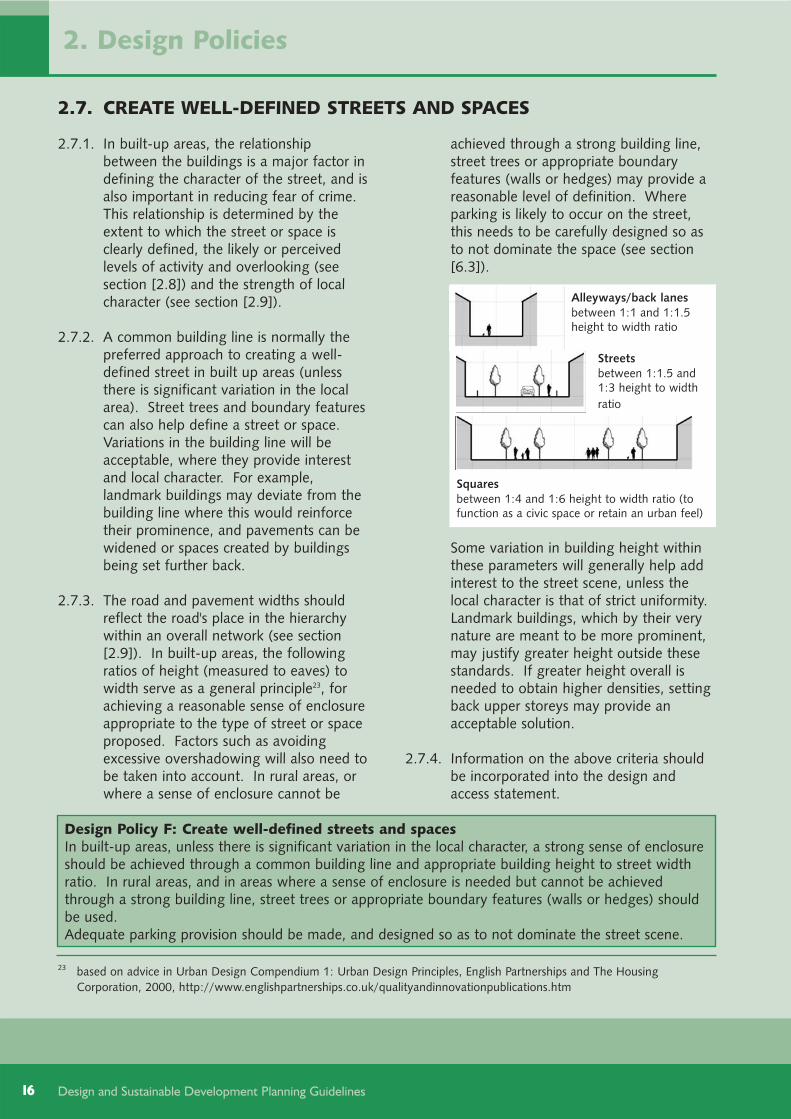
2.7.3. The road and pavement widths shouldreflect the road's place in the hierarchywithin an overall network (see section[2.9]). In built-up areas, the followingratios of height (measured to eaves) towidth serve as a general principle23, forachieving a reasonable sense of enclosureappropriate to the type of street or spaceproposed. Factors such as avoidingexcessive overshadowing will also need tobe taken into account. In rural areas, orwhere a sense of enclosure cannot be
achieved through a strong building line,street trees or appropriate boundaryfeatures (walls or hedges) may provide areasonable level of definition. Whereparking is likely to occur on the street,this needs to be carefully designed so asto not dominate the space (see section[6.3]).
Some variation in building height withinthese parameters will generally help addinterest to the street scene, unless thelocal character is that of strict uniformity.Landmark buildings, which by their verynature are meant to be more prominent,may justify greater height outside thesestandards. If greater height overall isneeded to obtain higher densities, settingback upper storeys may provide anacceptable solution.
2.7.4. Information on the above criteria shouldbe incorporated into the design andaccess statement.
2. Design Policies
Design and Sustainable Development Planning Guidelines
2.7. CREATE WELL-DEFINED STREETS AND SPACES
Design Policy F: Create well-defined streets and spacesIn built-up areas, unless there is significant variation in the local character, a strong sense of enclosureshould be achieved through a common building line and appropriate building height to street widthratio. In rural areas, and in areas where a sense of enclosure is needed but cannot be achievedthrough a strong building line, street trees or appropriate boundary features (walls or hedges) shouldbe used. Adequate parking provision should be made, and designed so as to not dominate the street scene.
23 based on advice in Urban Design Compendium 1: Urban Design Principles, English Partnerships and The HousingCorporation, 2000, http://www.englishpartnerships.co.uk/qualityandinnovationpublications.htm
Alleyways/back lanesbetween 1:1 and 1:1.5height to width ratio
Streetsbetween 1:1.5 and1:3 height to widthratio
Squaresbetween 1:4 and 1:6 height to width ratio (tofunction as a civic space or retain an urban feel)

2.8.1. Although West Dorset has a relativelylow rate of crime, particularly comparedwith the national average, some localresidents still don't feel safe particularlyafter dark24. It is important that publicareas are well used, appropriately lit andoverlooked, to reduce opportunities forcrime. Active and overlooked publicareas can also add interest to the streetscene (in contrast to large expanses ofuninteresting, blank walls), enhancing thequality and enjoyment of an area.
2.8.2. An appropriate level of activity on thestreet can be achieved throughdeveloping a mix of uses (see section[2.5]) and using spaces creatively.Extensive sections of blank walls orfencing facing onto public areas will notnormally be acceptable. Windows anddoors should face onto the street andother places where surveillance is needed(such as parking courtyards). The mainaccess to a building is generally best onthe front of the building facing the street,as this improves the level of activity onthe street. Where privacy is required forground floor rooms on busy streets, thiscan be achieved by raising the floorabove street level (subject to disabledaccess requirements) or providing aprivate front garden area.
2.8.3. Not all areas need to be overlooked, suchas rear gardens, where a degree ofprivacy is needed for people to enjoytheir own space (see section [7.5]). Suchareas should be clearly defined (withoutusing 'keep out' signs) so that people donot stray into them by accident. Designsshould also avoid creating easy,unobserved rear or side entry points forcriminals.
17
2. Design Policies
Design and Sustainable Development Planning Guidelines
Design Policy G: Create active and overlooked public areas and secure private areasDevelopment should normally:
Have the main access to a building at the front, facing the streetMake sure doors and windows face onto the street and places where surveillance is needed, and avoid blank walls enclosing public areasProvide a basic level of privacy at the rear of homes through either sufficient rear garden depth or orientation and screening to prevent direct overlooking.
Private areas should be clearly defined through appropriate boundary treatment, and care taken tolimit opportunities for the criminal to gain easy access to the rear of buildings and other privatespaces.
24 17% of local residents don't feel safe walking in their area after dark - West Dorset Performance Plan 2007
2.8. CREATE ACTIVE AND OVERLOOKED PUBLIC AREAS AND SECUREPRIVATE AREAS
Overlooked public area
Rear alley with little surveillance can increaseopportunities for crime

18
2.9.1. It is important that new development isread as being part of, and belonging to,the area in which it is placed. The overallsettlement form and street pattern, localfeatures (such as trees and spaces),together with building forms andtraditions (such as the materials used andstyles adopted), all help create a localidentity which distinguishes one placefrom another. A sense of local identity isimportant in establishing a sense of prideand ownership. Where there is a lack oflocal identity, the challenge for newdevelopment will be to create adistinctive place.
2.9.2. There is no reason why localdistinctiveness and innovation should notgo together, and in a way that supportsthe other objectives for good design andsustainable development. Traditionalmaterials and design ideas can be used ina totally modern way, and conversely,new materials and technologies can beused to create places and reflecttraditional styles. New and old buildingscan co-exist, if the design of the newresponds to the local context. Althoughdesigns may change to reflect moderntechnologies and good practice,development should still relate to thelocal area. Thought should be given tohow the transition is made between old
and new areas, so that the new does notfeel as if it has simply been dropped infrom another place with no thought to itslocal context. The treatment of the edgeof settlements is also important, althoughthe approach taken (either to provide ahard or soft edge) will vary depending onthe local character.
2.9.3. To help establish clearly the keycharacteristics that give an area itsindividuality, character assessments havebeen produced. These are obtainablefrom the district council offices andwebsite25, and include:
Appraisals of the main ConservationAreas
Urban character assessments of theremaining areas of the main towns
An assessment of the landscapecharacter of the rural parts of thedistrict.
2. Design Policies
Design and Sustainable Development Planning Guidelines
25 www.dorsetforyou.com/conservation/west, www.dorsetforyou.com/designguidelines/west andwww.dorsetforyou.com/landscapecharacter/west
2.9. MAINTAIN AND ENHANCE LOCAL CHARACTER
Tree lined avenues characteristic of Dorchester
Consider the transition between old and new

2.9.4. The settlement form, grain and pattern ofbuilding will normally reflect the historyof the place, the mix of uses and levels ofactivity. The overarching settlementform, its origins and opportunities forgradual (organic) growth, should berespected. And the road and pavementwidths should reflect its place in thehierarchy in an overall network (see alsosection [2.4]). Where there is a stronggrain or pattern of development (forexample, relating to plot widths) thatplays an important part in defining thecharacter of the street or reflects thehistory of the site, this should berespected, unless it would conflict withother objectives (in which case carefulconsideration should be given to how thetransition between old and new areas isdesigned).
2.9.5. The scale of development is important indefining the street (see section [2.7]) andshould relate to that of adjoiningbuildings (taking into account daylightand privacy issues (see sections [2.11]and [2.8])) and the general pattern ofheights in the area (in particular whetherthere is variety or uniformity). Cornerpositions and landmark buildings will tendto have more public-orientated uses andact as focal points. Development shouldnot obscure important views orsignificantly reduce the impact of locallandmark features (see section [7.3]).
2.9.6. The intention of this policy is to ensurenew development enhances localcharacter, not to duplicate existingdevelopments which in themselves maynot be of good quality. The designershould review the local building formsand traditions, selecting aspects from thispalette that are significant in the localcharacter, to reflect in the new design.This could include housing types,boundary treatments, building lines, roofshapes, window types, local materialsused and/or architectural detailing.Where there is a particularly strongcharacteristic, this should either beincorporated into the design orinterpreted in a more modern way.Designs or materials that would be highlyvisible (for example, because of theirprominence or contrasting style) will notbe appropriate, unless they are plannedas a landmark feature. Designs should
19
2. Design Policies
Design and Sustainable Development Planning Guidelines
Wider landscape character
Settlement form and traditions reflected in Bradford Peverell
New development blends with old in Tolpuddle

20
not significantly undermine the coherent,harmonious character of an area (forexample, where there is a particularlynotable palette of styles or materials).
2.9.7. The site assessment should identify theoverall settlement form and streetpattern, plus existing site features thatare either locally significant or importantin the wider landscape character. Where
there are no such features in the localarea, it may be appropriate to considerintroducing some that can reinforce thewider landscape character (see section[2.2]). Information on how thedevelopment has responded to localidentity and addressed theseconsiderations should be incorporatedinto the design and access statement.
Design and Sustainable Development Planning Guidelines
Design Policy H: Maintain and enhance local characterNew development should be influenced by the local building forms and traditions, materials andarchitectural detailing that are significant in the local area, and maintain or, where appropriate,enhance local character. Where development is proposed in or on the edge of an existing settlement, any new routes shouldrespect their place in the hierarchy within the overall network, and the design of the developmentshould be influenced by the need to define or soften the transition between areas of differentcharacter.Where new plots are being formed, these should reflect the existing grain and pattern ofdevelopment where these form a significant characteristic in the street scene, unless this wouldconflict with other policies. New development should not be disproportionate in size to adjoining buildings in the locality, unlesswarranted by its proposed use and position on the street. It should not introduce building forms,traditions, materials or architectural detailing that are alien to the area unless these would eitherprovide significant sustainability benefits that cannot otherwise be delivered or the elements can beaccommodated in a way that will enhance local character.
New development responding to old, Dorchester

21Design and Sustainable Development Planning Guidelines
2.10.1.High quality architecture should result inattractive development in which thecommunity feel a sense of ownership andpride. This can depend on factors suchas:
The relationship between wall spaceand windows (technically known asthe solid to void ratio). In traditionalbuildings the construction techniquesand materials available kept windowssmall with large areas of wallsurround. Modern building techniquesand in particular advances in themanufacture of glass has meant thatthe size and distribution of windows isno longer restricted, and glazed areascan effectively take up a much higherproportion of the wall space
The proportion, elegance, scale,symmetry (or asymmetry) andpositioning of its doors and windows(in good designs, these help establisha vertical or horizontal emphasis orpattern and the same proportion maybe repeated or reoccur elsewhere inthe design to achieve a visuallybalanced result)
The richness of detail (particularlyimportant on landmark buildings andat ground level, where it is seen closeat hand). Unless there is a particularlystrong sense of uniformity, designsshould allow for some variation andexpression of individuality. It is alsoimportant that good quality shouldspan the whole development, and
variation in designs should nothighlight particular groups in society(affordable housing, for example,should not look different from similarlysized private housing).
The quality of materials used andworkmanship, both in terms of theirappearance and future maintenancerequirements.
The coherence or harmony with thesurrounding development and theextent to which any changes mightreinforce local character (see alsosection [2.9])
The latter three points are also relevantto landscaping schemes.
2.10.2.In an existing building, or an extension toit, the design and materials used shouldrespect the character and appearance ofthe original building.
2. Design Policies
2.10.CREATE HIGH QUALITY ARCHITECTURE
Design Policy I: Create high quality architectureDevelopment should create high quality architecture appropriate to the type of building andarchitectural style through:
Ensuring buildings have an appropriate solid to void ratio Ensuring buildings have a sense of proportion, elegance, scale, symmetry and rhythm Incorporating an appropriate richness of detail (without clutter)The use of good quality materials
In an alteration or extension to an existing building, the design and materials used should respect thecharacter and appearance of the original building.
Attention to detail, Poundbury

22 Design and Sustainable Development Planning Guidelines
2.11.1.All new homes are now rated against theCode for Sustainable Homes. Non-residential buildings and major alterationsto existing homes can be rated againstBREEAM (Building ResearchEstablishment's Environmental AssessmentMethod). These measure thesustainability of a building against arange of design categories, settingprogressively higher standards ofenvironmental performance. Althoughthe regional planning body was keen tospecify a minimum code level for all newhomes in the South West, the Secretaryof State removed this requirement fromthe regional strategy on the basis thatsuch advances would be driven throughchanges to the building regulations.Although this council has not set aminimum standard, it will encourageowners and developers to attain thehighest practical Code for SustainableHomes levels (or equivalent BREEAMrating) in all new development, and willmonitor the code ratings achieved. Formore information on the Code andBREEAM, see Appendix [2].
2.11.2.A significant amount of energy andresources is expended on the constructionof new buildings26. Choosing the rightlocation away from areas that are proneto flooding or land instability is a keyfactor in ensuring a development'sdurability (see section [2.2]). The rightdesign and materials will also play animportant role in increasing the life of thedevelopment. Development that is easy
to maintain and can adapt to meet theneeds of a range of potential users willlast longer and will also be less likely toremain vacant for long periods. Thelifecycle costs27 of the primary materialsused in the construction of floors, roofs,walls should be considered (the GreenGuide to Specification28 assesses the mostcommon building materials, which areranked from A+ to E, where A+represents the best environmentalperformance with the least environmentalimpact, and E the worst).
2.11.3.In the UK, much of our carbon emissionsand water consumption are caused by theuse of buildings29. By installing devicesthat use water and energy moreefficiently, and using renewable sourceswhere practical, there is potential forsignificant carbon and water30 savings.Although the reduction of energy use andcarbon emissions will largely comethrough revisions to BuildingRegulations31, there are a number of
2. Design Policies
26 In 2001, the Green Guide to Specification, BRE, estimated that 10% of energy use in this country was associated withconstruction materials and methods
27 the overall costs from "cradle to grave", taking into account factors such as the potential climate impact, scarcity ofresources (used in manufacturing or transport), possible harm to human, animal and plant health (from the end-product ormanufacturing process), water used and disposal of waste
28 Green Guide to Specification, BRE, online version www.thegreenguide.org.uk.29 Building Regulations Advisory Committee SDC Report on Existing Building Stock, BRAC(06)P5, ODPM, 200630 Although existing water resources are not predicted to be over-stretched in this area, the average levels of water use in the
home is over 150 litres per person per day, which is much higher than the standards set in the Code for Sustainable Homeswhich requires mandatory maximum water consumption of 120 litres/person/day to achieve Code Level 1.
31 Building a Green Future: policy statement, 2007, DCLG
2.11.ACHIEVE HIGH STANDARDS OF ENVIRONMENTAL PERFORMANCE
Wind turbine installed at Dorset School

23Design and Sustainable Development Planning Guidelines
factors that need to be taken intoaccount at the early design stage, toensure the best fit of design andtechnology is achieved, appropriate tothe character of the building and localarea32. These include opportunities to usethe landform and landscaping, togetherwith the building shape, orientation andpositioning, to minimise energyconsumption and carbon dioxideemissions, and limitations imposed bylandscape and townscape sensitivity (seesection [2.9]), and viability. Furtheradvice on orientation and passive solardesign is given in section [7.7]
2.11.4.Energy-efficient systems and systems thatcan generate renewable and low-carbonenergy are needed to help reduce ourdependency on scarce fuel resources,reduce the amount of pollutiongenerated, and reduce the running costsof buildings. These systems will besupported, provided that the impact onthe character and amenity of the area isacceptable. In assessing this,consideration will be given to the scaleand effectiveness of the potential carbonsavings, as well as the character andsensitivity of the landscape and buildings.Proposals for 10 or more dwellings ormore than 1,000 square metres of non-residential floor area will be expected todemonstrate how the development willcontribute towards renewable energygeneration targets set in the developmentplan33. Where there are no feasible andviable technologies that can beaccommodated to achieve this level of
energy generation without unacceptableimpacts, the best endeavours should bemade to source a lesser percentage ofenergy from decentralised and renewableor low-carbon sources. See sections [4.8]and [4.9] for further advice.
2.11.5 Homes that meet the 16 LifetimesHome34 criteria are encouraged by thecouncil (see accompanying informationsheets on sustainable technologies).Provision for working at home is alsoencouraged in residential developments35.The provision of space that can be usedto store bicycles, or used for a pram orelectric mobility scooter, space for thestorage of waste (for recycling anddisposal) and drying space is alsoencouraged. Daylight requirements (bothwithin the planned building and toneighbouring properties36) also need to beconsidered (see section [7.5]).
2. Design Policies
32 para 42, Planning and Climate Change Supplement to PPS1, 2007, DCLG33 The draft Regional Spatial Strategy (July 2008) requires that at least 10% of the energy use will come from decentralised
and renewable or low-carbon sources. Further targets may be developed through future development plan documents. 34 See www.lifetimehomes.org.uk. The health and wellbeing criteria in the Code for Sustainable Homes currently includes a
mandatory requirement for Lifetime Homes at code level 6, and from 2010 this will be mandatory at code level 4 and in2013 at code level 3.
35 The Code for Sustainable Homes awards credits for providing sufficient space and communication connections within thehome to enable effective use as a home office. It is not anticipated that provision for working from home would changethe use class or require subsequent planning consent.
36 Site Layout Planning for daylight and Sunlight - a Guide to Good Practice, 2002, BRE provides further guidance.
Ecohomes at Poundbury

24 Design and Sustainable Development Planning Guidelines
2.11.6.Sustainable drainage systems will beneeded to help deal with surface waterdrainage and alleviate flooding. Anylarge areas of hard surfacing (over 5square metres) should normally be madepermeable. The use of infiltrationtrenches, swales, ponds and wetlandsshould also be considered. Rainwaterharvesting is a practical solution that canbe accommodated in most new homes.
2.11.7.In order to help understand the potentialopportunities, limitations and costs ofsustainable technologies, the council hasproduced a range of information sheetson the most common and/or effectivetechnologies. Information on how thisprinciple has been addressed in thedesign should be incorporated into thedesign and access statement.
Design Policy J: Achieve high standards of environmental performanceThe council encourages owners and developers to attain the highest practical Code for SustainableHomes levels (or equivalent BREEAM rating) in all new development. The council will encourage owners and developers to design to last, and incorporate measures toreduce energy use and carbon emissions, and this can be achieved through ensuring newdevelopment:
Avoids using those materials most harmful to the environment (those given a 'D' or 'E' rating in theGreen Guide to Specification). Is readily adaptable to accommodate likely needs for storage, and the needs of people with disabilities Anticipates and accommodates the full extent of landscaping once maturedTakes advantage, where practical, of the benefits of passive solar design as part of an overall approach towards reducing the need for conventional energy sources in providing heating, light and ventilationDoes not reduce daylight levels to an unacceptable level.
Where practical, new homes should be designed to Lifetime Homes Standards, and make provisionfor drying space and working from home.The council will encourage owners and developers to use sustainable drainage systems to help dealwith surface water drainage and alleviate flooding wherever practicable in the design of development.In areas with known flooding issues, or where extensive areas of hard surfacing are required, the hardsurfacing should be permeable. Where practical, the council will encourage homes to have systems inplace to collect rainwater for use and those that have a communal space to make provision forcomposting garden waste.
2. Design Policies
Green roof at Kingston Maurward
Crossways school design considered green options

25Design and Sustainable Development Planning Guidelines
3.1. Things to consider:
3.1.1. In designing a development it isextremely important to provide goodconnections to the surrounding areas,and a layout that is easy to understand,creates walkable spaces and reducesreliance on motor vehicles. The streets,paths and open spaces also need to bedesigned so that they feel safe andpleasant for those on foot or cycle, tofurther encourage healthy recreation andsocial interaction. The layout of the routenetwork will also have a bearing on theefficient use of land, particularly plot sizeand shape and surplus spaces.
3.1.2. The next sections answer the followingfrequently asked questions:
3.2 Who do I need to involve?3.3. What is likely to be the most
appropriate form of development?3.4. How do you reinforce local character
and produce an understandablelayout?
3.5. What should I do if local character isbased on street patterns thatwouldn't be acceptable under thesepolicies?
3.6. How should traffic speeds bemanaged?
3.7. Should pedestrian and bicycle routesrun alongside from the street?
3.8. What provision should be made forbuses?
3.9. How much public open space will beneeded and where should it belocated?
3.10.What materials should I use?3.11.Are there standards for the width or
gradient of pavements?3.12.Should kerbs be used or are shared
surfaced areas acceptable?3.13.What level and type of lighting
should be used?3.14.How should I include public art?3.15.Who is responsible for the on-going
maintenance of public spaces?
3.2. Who do I need to involve?
3.2.1. Most development creating new streetsor open spaces will be significant in size.As such, considerable effort should bemade to engage with the range and typeof users that may use the spaces, as wellas those responsible for street furnitureand the like. The work of artists shouldbe integrated into the design process atthe earliest possible stage to have themaximum benefit. An ecologist and civilengineer should also be engaged early onto advise on opportunities for integratingwildlife and sustainable drainage as partof the landscaping plan.
3.2.2. Local residents and the wider communityshould be involved in the design and,where appropriate, the ongoingmaintenance of public open spaces andpedestrian areas. Because the designshould ensure that public spaces areaccessible to everyone, disabled users ortheir representatives should be contactedas soon as possible.
3.3. What is likely to be the mostappropriate form of development?
3.3.1. The perimeter block37 is a tried and testedtype of structure for providing aconvenient and well-connected layout onlarger development sites. It limits theamount of space given to roads andturning areas for vehicles, and offersgood levels of security to the backs ofproperties. It can take a wide variety offorms, including rectangular blocks basedon a grid, concentric or circular patternsdesigned to promote access to localcentres or public transport routes, andmore irregular layouts with an 'organic'character which look like they have beendeveloped over some time.
3. Streets, Paths and Open Spaces
37 where buildings are located on all sides of a block, each facing onto the street, with private gardens meeting in the centre

26 Design and Sustainable Development Planning Guidelines
3.3.2. In contrast, winding cul-de-sac estatelayouts with local distributor or serviceroads are not well-connected and are nottypical of the character of many WestDorset towns and villages. They cancreate unused spaces, have long stretchesof blank walls or fencing whereproperties back onto public routes, andare more difficult to understand. Culs-de-sac and turning areas for vehiclesshould only be considered wheretopography, boundary or other limitationsmean there is no acceptable way tocreate a more permeable layout.
3.3.3. The degree to which access and carparking should be provided in a block(through internal courtyards) will dependupon whether the benefits this provides
(in terms of making more efficient use ofland and reducing the amount ofprovision needed for parking on-streetand in driveways) are balanced by thedisadvantages (in terms of safety andsecurity, and the amenity value of backgardens). More information is providedin section [6].
3.4. How do you reinforce local characterand produce an understandablelayout?
3.4.1. The site assessment and informationcontained in the relevant landscapecharacter, urban character assessments orconservation area appraisals (see sections[2.2] and [2.9]), should help youunderstand the settlement form andidentify local features that should beincorporated into the development tohelp reinforce local character.
3.4.2. The design of routes, stopping places(junctions and public open space), use oflandmark features and views to andbetween these features (which can bereinforced by the underlying topography)should be used to make it easier forpeople to understand the layout and findtheir way about:
Routes should be designed to reflecttheir status in the network and type ofuses found within them. The widthsshould reflect the likely levels ofvehicular and pedestrian traffic,creating an understandable hierarchywithin an overall network providingthis would not undermine the route’shistoric significance. The alignment orcurvature is also important, as gradualand unmarked changes along acontinuous route give rise toconfusion, and therefore are betteravoided on the more principal routes(see section [2.4]). Where practical,routes should broadly follow desirelines.
Stopping places (junctions andpublic open space) should be
3. Streets, Paths and Open Spaces
Use a perimeter block layout
Avoid poorly connected cul-de-saclayouts

27Design and Sustainable Development Planning Guidelines
provided on the road network either inthe area or acting as a point of entry.The spaces should be well defined,normally by the surrounding buildings,to help reinforce their importance.
Landmarks (important and memorablebuildings or landscape features) shouldbe where they can be seen (forexample, to terminate a route or marka stopping place). Their design(through their height, position in thestreet and the quality and detail oftheir design) and their use shouldreflect their importance and contributepositively to the street scene. Ingeneral, uses that generate higherlevels of activity will be moreappropriate for landmark buildings.Any historical associations willstrengthen a landmark's identity.
3.5. What should I do if local character isbased on street patterns thatwouldn't be acceptable under thesepolicies?
3.5.1. Where possible, street design shouldrespond to the settlement pattern andlocal character. However, the need tocreate walkable places is the mostimportant consideration. The likely level,type and speed of traffic, pedestrianactivity, and need for parking may alsonecessitate a revised approach.
3.6. How should traffic speeds bemanaged?
3.6.1. In residential areas, or where there arehigh levels of pedestrian activity, thedesign should aim to keep traffic speedbelow 20mph. This should be managedby the arrangement of buildings andspaces, without the need for conventionaltraffic-calming measures such as signs,speed humps and chicanes.
3. Streets, Paths and Open Spaces
Avoid designing in unwelcoming linksAdd the kerblineto reinforce the
space
First place thebuildings
Identify the mainvehicle track and
potential foronstreet parking

28 Design and Sustainable Development Planning Guidelines
3.6.2. Changes in materials or narrowing at theentrance to these areas can alertmotorists to the need to reduce speed.This can be reinforced within the area byusing tight corners and reduced visibility(for example, by bringing buildingsforward to a corner) that requires morecareful vehicle movement. Tight cornersalso provide more direct and saferpedestrian crossing points than large radiijunctions. Experience has shown that thelengths and links in a permeable layoutcan provide a good basis for controllingspeeds effectively. Long, straight streetscan lead to higher traffic speeds and as ageneral principle an uninterruptedstraight stretch of more than 70m shouldbe avoided38. Separate service ordistributor roads will not normally beappropriate unless the traffic flow isextremely high39.
3.6.3. In rural areas, changes to existing roadsor the provision of new routes willnormally be carried out by Dorset CountyCouncil and will be guided by the DorsetRural Roads Protocol. This recognisesthat attempts used in the past to reducetraffic speed have often relied on signsand hard engineering, which can have anegative impact on our environment by
eroding character and 'urbanising' ruralareas. Instead, the county council willlook to use features in the environment,such as hedgerows, bends, restrictedsight lines, boundary walls or buildings,or changes of road surface, tocommunicate to the driver that hazardsexist and extra vigilance should beexercised.
3.7. Should pedestrian and bicycle routesrun alongside the street?
3.7.1. Providing a totally separate pedestrian orbicycle route away from the street shouldonly be considered as a last resort. Therewill however be exceptions. For example,historic railway lines may be re-used forrecreational routes. Where routes areplanned away from development andwould not be overlooked by buildings,the potential fear of crime will need to becarefully considered.
3. Streets, Paths and Open Spaces
38 para 7.4.3 of Manual for Streets, DCLG and DfT, 2007 advises that evidence from traffic-calming schemes suggests thatspeed-controlling features are required at intervals of no more than 70m in order to achieve speeds of no more than20mph.
39 section 7.9 of Manual for Streets, DCLG and DfT, 2007 suggests that the limit for providing direct access on roads with a30mph speed restriction is at least 10,000 vehicles per day.
Street trees used in Sherborne
Rural roads approach

29Design and Sustainable Development Planning Guidelines
3.8. What provision should be made forbuses?
3.8.1. The county council and local publictransport operators can advise onplanning for a thriving bus network.
3.8.2. Streets currently or likely to be used bybuses should be identified in the designprocess. In general routes are more likelyto succeed if they are reasonably directand can give priority to buses at junctionsor links where delays may occur. This willreduce journey times. They should alsorun in or between well-populated areas inorder to attract sufficient passengernumbers to be viable.
3.8.3. Streets on bus routes should be at leastsix metres wide (although this can bereduced on short sections). The presenceand arrangement of on-street parking,will also need to be considered indeciding the street width.
3.8.4. Bus stops should be where people canwalk to them easily, they should beclearly visible and located where their useis unlikely to cause undue noise nuisance.Although walking distances will vary, thespacing of stops should aim to ensurethat the majority of the likely catchmentpopulation are within 400 metres from abus stop.
3.9. How much public open space will beneeded and where should it belocated?
3.9.1. Public open space can perform a range offunctions, as well as being an importantelement in the identity and character ofan area. The council's audit andassessment of open space, sport andrecreation facilities40 identified seventypes of open space, ranging from quiet,informal areas and natural greenspace, tomore urban civic squares, active playareas and sports pitches41. The size of thespace will also depend on the activitiesproposed, and its relation to surroundingbuildings (see section [2.7]). Planningobligations guidelines are being producedthat will include further guidance onwhat is required from individualdevelopments.
3. Streets, Paths and Open Spaces
40 PPG17 study: audit and assessment of open space, sport and recreation facilities, 2007, WDDChttp://www.dorsetforyou.com/index.jsp?articleid=374563
41 The types identified were: ·parks, gardens and recreation grounds - including formal gardens laid out with floral landscaping, grassed areas and seating, as well as sites used as informal areas for recreation or having a range of facilitiesamenity greenspace - highly accessible and generally more 'urban' spaces that function as market squares, improve the visual appearance of the area or provide opportunities for informal activities e.g. dog walking or kick aboutallotments - providing opportunities for those who wish to grow their own produce play areas for children and young peopleformal outdoor sports provision, including football, cricket, rugby and hockey pitches, bowling greens, tennis courts and golf coursesnatural and semi natural greenspace - including nature reserves, woodlands, areas set aside for wildlife conservation, environmental education awareness and countryside recreation such as walking or cyclingcemeteries.
Different open space types, Bridport

30 Design and Sustainable Development Planning Guidelines
3.9.2. Because of its potential to act as a featurethat will help people find their wayabout, public open space should belocated on a junction or where it may bemore prominent in local views. It shouldalso be overlooked from nearbyproperties to provide natural surveillanceand reduce the fear of crime. Howeverpotential noise or disturbance to peoplein nearby homes will also need to begiven careful consideration.
3.10. What materials should I use?
3.10.1.The choice of materials should reinforcelocal character and a sense of place,although where this would require theuse of materials that are the mostharmful to the environment (according tothe Green Guide to Specification), analternative material should be used. Thematerials will also need to be appropriateto the anticipated levels and type of use.Imported materials foreign to the south
west region, for example Spanish slates,Chinese granite and Indian sandstone,should be avoided not least because oftheir poor environmental performance.
3.10.2.Some surfacing materials, such as stonesetts and loose gravel, may generateother problems such as noise and createdifficulties for wheelchair users. Gravelsurfaces will need to be fixed, forexample by being resin bonded or boundinto the tarmac surface. In general, pathsshould be smooth and slip resistant. It isimportant to consider the likely futuremaintenance requirements, to ensure thatthe quality and appearance of the schemecan be sustained.
3.10.3.Where historic surfaces exist, these canhelp define local character and addconsiderable value to the appearance andperception of a place, and unless there isgood reason it is expected that theseshould be incorporated into the design,rather than removed or covered over.
3.10.4.Large expanses of hard surfacing, ifneeded, can be made less intrusive if thepredominant material (such as tarmac) iscombined with areas of higher qualitysurfacing or paving (an example of thiscan be seen at Cart Road in Lyme Regis).Consideration should also be given tousing specially designed permeableasphalt or block surfacing to reduce theamount of surface water run-offgenerated by the extensive areas of hardsurfacing in the development.
3. Streets, Paths and Open Spaces
Different open space types, Bridport
Crossing design reflecting local context, Fordington
Traditional paving in Sherborne

31Design and Sustainable Development Planning Guidelines
3.10.5.By involving the community in thedesign, potential problems should behighlighted and alternative solutionsexplored. This may mean that only partsof the surface use the traditional material,or that alternative materials thatharmonise with the adjoining surfaces areused but laid in a traditional pattern.
3.10.6.Tactile paving will be needed atpedestrian crossing points. Historic areasare more sensitive to the colour and typesof paving used, so the standard red andbuff coloured concrete paving may notbe appropriate. Alternative solutions,such as contrasting shades, changes insurface texture or inserting studs shouldbe explored. Drainage gullies and coversand other infrastructure requirements areusually needed. If possible these shouldbe installed as an integral part of thedesign, and not as an afterthought.
3.11. Are there standards for the width orgradient of pavements?
3.11.1.The minimum unobstructed width ofpavements should generally be 2 metres,although greater widths will be requiredat bus stops, shopping areas and otherplaces of high pedestrian activity.Obstructions from signposts, lightingcolumns, trees, litter bins, refuse bags leftout for collection, seating and otherstreet furniture, can be a hazard for blindor partially-sighted people.
3.11.2.Where a 2 metre pavement is notpossible, the absolute minimum should be1 metre (although in some historic areaswhere the street is confined by listedwalls, even this may not be possible). Itis important that liaison with the highwayauthority, disabled groups and theagencies responsible for street furnitureshould begin at an early stage, so that alloptions can be considered. Specificprovision for bins may need to beaccommodated at the kerbside wheregroups of properties do not front ontothe highway, to avoid waste collectionscluttering the pavement.
3.11.3.It is advisable to avoid steep gradients onpedestrian routes. Gradients forpedestrians should ideally be no morethan 5% (1 in 20), although topographyor other circumstances may make thisdifficult to achieve. Steeper gradients (upto 8% or a 1 in 12 incline) may beacceptable over very short distances(ideally less than 2 metres, and certainlyno longer than 10 metres). The cambershould not exceed 2.5% (1 in 40) or varyfrequently, as this will cause problems forwheelchair users and those with walkingdifficulties. All raised pathways should
Remember to consider tree growthwhen surfacing
Pavement width confined by listed wall, Sherborne

32
have a lip to prevent wheeled buggiesand wheelchairs going over the edge.
3.12. Should kerbs be used or are sharedsurface areas acceptable?
3.12.1.In settlements, kerbs should normally beused to separate pedestrian areas fromtraffic, as they offer some protection topedestrians, assist blind or partially-sighted people in finding their wayaround, and can help channel surfacewater. However, the widespread use ofsmooth faced, precast concrete kerbs,generally 150 millimetres high, hasbrought a standardised appearance tohighway design. The designer needs toevaluate both the engineering needs ofhighway design and the relevance oflocal context in determining the bestsolution42. A good example of localcontext in this respect can be found inAbbotsbury where the kerbstones used inGlebe Close takes reference from themuch older parts of the village.
3.12.2.Shared surface areas may provide anacceptable solution in areas wherevehicular traffic levels are very low, andthere is no real need or benefit ofdefining a clear pedestrian route. Thishas the potential to make more efficientuse of land, but the resulting design willalso need to be in keeping with localcharacter. At heavily pedestrianisedjunctions (such as outside a school) itmay be appropriate to bring thecarriageway up flush with the pavementto slow vehicle speeds and allow peopleto cross on one level.
3.13. What level and type of lightingshould be used?
3.13.1.Effective lighting may be needed toachieve good visibility and reduce fear ofcrime. Care needs to be taken to avoidunnecessary light pollution, and minimiseclutter in the street environment. It isimportant that lighting engineers areinvolved at an early stage in the projectdesign. Lighting can come from a varietyof sources, including conventionaloverhead street lamps, building-mountedlights, bollards, and even lighting fromshop windows. Standard lighting systemsfor highways may not always beappropriate to the local character. Ifstreet lighting is needed, solar energyshould be considered where practicable.
Design and Sustainable Development Planning Guidelines
42 Manual for Streets gives information about the design considerations (section [7.2])
Bespoke kerbing, Abbotsbury
Lighting to reflectlocal character,
West Bay

3.14. How should I include public art?
3.14.1.Public art and design can help raise thequality of a development. There aremany areas where a creative and designled approach can provide additionalbenefits. For example, an artist maygenerate new ideas about how thedevelopment could respond to andenhance local character, draw attention tolocal links, add new landmarks ormemorable places. The preferredapproach on larger schemes is to involvean artist within the design process at anearly stage, to influence the design andhow it responds to the site, and integratequality craftsmanship into the design.
3.15. Who is responsible for the on-goingmaintenance of public spaces?
3.15.1.The upkeep of streets, paths and openspaces needs to be on-going, to ensurethat the quality of spaces does notdeteriorate over time (which can affectpeople's enjoyment, encourage vandalismand require costly restoration work).
3.15.2.If development results in new streets,paths and open spaces, the council willnormally attach conditions or require alegal agreement, ensuring appropriateprovision is made for future maintenance.The council will encourage the transfer ofsuch land into public ownership, althoughmaintenance by the local community,through a management company or
similar measure, may be accepted. Acommuted sum will normally be requiredto cover the ongoing costs ofmaintenance.
3.15.3.A condition may also be imposedspecifying the maintenance of anylandscaping scheme on private land for aminimum period (normally at least fiveyears).
33Design and Sustainable Development Planning Guidelines
Shelter as local landmark, Poundbury

34 Design and Sustainable Development Planning Guidelines
4. Utilities Infrastructure Requirements
4.1. Things to consider:
4.1.1. The main utilities associated with newdevelopment are water, drainage (surfaceand foul water), electricity, gas andtelecommunications services. In mostcases there are established operators inthe area, and a developer will deal withthem direct. However, the matter maybecome a planning issue because of otherimpacts.
4.1.2. The next sections answer the followingfrequently asked questions:
4.2. Who do I need to involve?4.3. How do I get connected to an
existing utility supply?4.4. What do I do if electricity lines
run over or close to my site?4.5. How should I deal with surface
water drainage?4.6. What happens if there may be a
risk of contamination?4.7. How can I reduce the amount of
water used?4.8. How can I produce renewable
energy?4.9 Do I need permission to retrofit a
renewable energy system to my house?
4.2. Who do I need to involve?
4.2.1. There will generally be a need forsustainable drainage systems (oftenreferred to as SUDS) for all newbuildings. These systems requiremaintenance. Details should be discussedwith the Technical Services division of thedistrict council before submitting anapplication43. In areas of flood risk, orwhere surface water run-off may be high,or where the land is contaminated, the
Environment Agency should be asked foradvice.
4.2.2. You will also need to talk with therelevant utility services to check whetherthere is any existing infrastructurerunning across your site, and also howyour development may connect to thelocal network.
Contact Wessex Water Services44 (orSouth West Water45 for Lyme Regis)for information on the local water andsewerage network
Contact BT Openreach46 forinformation on the localtelecommunications network
Contact Southern Gas Networks47 forinformation on the local gas network
4.2.3. If the building work may affect theseservices, it is the owner's or developer'sresponsibility to contact the serviceprovider to discuss any necessary actionand costs.
4.2.4. Liaison with experts in designing energyefficient buildings is needed, if the designis to consider all opportunities to reducingthe amount of non-renewable energyused.
4.3. How do I get connected to anexisting utility supply?
4.3.1. The utilities infrastructure will need to beadopted by an appropriate, competentorganisation, such as the local utilitiesprovider, to ensure that it is managed andoperates as designed for the life of thedevelopment. Network modelling maybe needed to decide how the siteconnects to the existing network, and any
43 For further guidance refer to the West Dorset District Council Strategic Flood Risk Assessment (SFRA), 2008, PPS25:Development and Flood Risk - Practice Guide, 2008, DCLG and the CIRIA website www.ciria.org/suds/
44 www.wessexwater.co.uk45 www.southwestwater.co.uk46 www.openreach.co.uk47 www.southerngasnetworks.co.uk

35Design and Sustainable Development Planning Guidelines
need for off-site reinforcement to ensureadequate supplies. Where reinforcementor other works is required, the owner ordeveloper will be expected to contributeto the cost of these works, and these maybe subject to a planning obligation.
4.4. What do I do if electricity lines runover or close to my site?
4.4.1. Where electricity lines run over or closeto a site, the type and location ofequipment in relation to the planned use,structures and landscaping of thedevelopment may be assessed as part ofthe planning process.
4.4.2. A proliferation of poles and overheadwires can have a detrimental impact onthe character and appearance of an area,and the council will encourage theundergrounding of such services wherepractical. Although requests to removecables or place them underground areconsidered by the operators, the costsinvolved and possible operational or otherlimitations, means this cannot beguaranteed. If development needsconnection to the national grid, theowner or developer will need to contactthe local distributor48.
4.5. How should I deal with surfacewater drainage?
4.5.1. If ground conditions are suitable, the bestway of disposing of surface water is byincorporating a sustainable drainagesystem (SUDS) to reduce flood risk byreducing the rate and quantity of surfacewater run-off from a site. This approachcan involve a range of techniques
including soakaways, infiltration trenches,permeable pavements, grassed swales,ponds and wetlands. Building regulationsset the minimum standard49. The Codefor Sustainable Homes includes anobligatory requirement that the peak rateof run-off into watercourses is no greateras a result of the proposeddevelopment50. Rainwater harvesting canplay an important role in reducing surfacewater run-off.
4.6. What happens if there may be a riskof contamination?
4.6.1. In areas of flood risk, or where surfacewater run-off may be high, or where theland is contaminated, it is particularlyimportant to consider how surface wateris controlled to avoid creating anyproblems. The Environment Agency canadvise on how best to minimise the risksof pollution, and what measures shouldbe part of any scheme.
4.7. How can I reduce the amount ofwater used?
4.7.1. Information on water-saving devices(rainwater harvesting, grey waterharvesting and water efficient fittings) isprovided in the council's sustainabletechnologies information sheets.
4.8. How can I produce renewableenergy?
4.8.1. The Government has made acommitment to generate at least 10% ofelectricity from renewable sources51 by2010, rising to 20% in 2020 and 40% in205052. To contribute to these national
4. Utilities Infrastructure Requirements
48 http://www.nationalgrid.com/uk/Electricity/AboutElectricity/DistributionCompanies/49 Approved document H - drainage and waste disposal, 2002, ODPM
http://www.planningportal.gov.uk/england/professionals/en/1115314110382.html50 Where the additional predicted volume of rainwater discharge is significant, it should be reduced either through using
infiltration techniques or rain water harvesting.51 Renewable sources (based on the Renewables Obligations Order) include: biogas (such as that generated from landfill or
sewage waste); biomass (from wood or energy crops); hydro power (including tidal, tidal stream and wave power); windpower; geothermal power; and solar power
52 Energy White Paper, HMSO, 2003

36 Design and Sustainable Development Planning Guidelines
targets, Dorset is expected to be able togenerate in the region of 75 MW ofelectricity from renewable sources by2010, and take its share of the 850 MWof electricity from renewable sources by202053. Renewable heat targets are alsolikely to be introduced for the region.
4.8.2. There are a number of factors that needto be taken into account at the early
design stage, to ensure the best fit ofdesign and technology is achieved,appropriate to the character of thebuilding and local area54. In order to helpunderstand and encourage the mostappropriate forms of renewable electricitygeneration, the council has produced arange of information sheets on the mostcommon or effective technologies forWest Dorset. The key planning issues are
4. Utilities Infrastructure Requirements
53 recommendations from REvision 2020, South West Renewable Electricity, Heat and On Site Generation Targets for 2020,June 2005, produced by Centre for Sustainable Energy on behalf of Government Office for the South West and the SouthWest Regional Assembly
54 para 42, Planning and Climate Change Supplement to PPS1, 2007, DCLG55 information on average windspeed at 10m and higher above ground level can be found at
http://www.bwea.com/noabl/index.html, however a local assessment is advised as the data relates to 1km squares andtakes no account of topography on a small scale or local surface roughness, both of which may have a considerable effecton the wind speed.
Source Overview Planning issues
Solarphotovoltaicsand solarwaterheating
Well-proven and flexibletechnology, althougheffectiveness will depend onorientation and angle ofmounting
Potential impact on local character, particularlyif the building is Listed or within aConservation Area, and the effect of longdistance glare. Careful positioning mayovercome these concerns
Windturbines
Wind speeds need to exceed3 metres per second tooperate and therefore small-scale turbines may not beeffective in built-up areas55
The height and number, colour, position inrelation to buildings, potential noise anddisturbance, impact on views and localcharacter will be considered. Careful designand positioning may overcome these concerns
Biomass andbiogasboilers
Single boilers well proven, butlarger combined heat andpower (CHP) schemes arerelatively new. Energy is bestsourced locally from improvedwoodland management orwaste, to minimise widerpotential environmental costs
Small-scale boilers: potential impact of the flueon local character, particularly if the building isListed.Large plants: potential impact from vehiclemovements and air quality, and visual impactof new buildings on local character
Ground andair sourceheat pumps
Although requiring an energysource to operate, theefficiency savings are classedas renewable. Thistechnology may not alwaysbe effective for hot waterbecause of the highertemperatures required
Ground source heat pumps: potential impacton archaeological interests or land stability Air source heat pumps: the externally mountedcomponents may have a potential impact onlocal character, particularly where the buildingis Listed or within a Conservation Area.Careful positioning may overcome theseconcerns, and also reduce any potential impacton neighbours caused by noise and vibration

37Design and Sustainable Development Planning Guidelines
summarised below. Where planningissues are highlighted, early contact withthe council is advised.
4.9. Do I need permission to retrofit arenewable energy system to myhouse?
4.9.1. Planning permission is no longer requiredfor some microgeneration technologieson homes and buildings in gardens. Thisis subject to certain criteria56 summarisedhere. If you are unsure whether yourscheme needs permission please contactthe council. This applies to:
solar photovoltaics or solar thermalsystems
ground source heat pumps
water source heat pumps
the flue for a biomass heating orcombined heat and power systems.
There are plans to extend these rights towind turbines and air source heat pumpsonce clear standards on noise andvibration are agreed.
4.9.2. Permitted development rights are subjectto the equipment being sited to minimiseits effect on the external appearance ofthe building and amenity of the area (sofar as practicable). In the case of solarmicrogeneration technologies, theequipment must be removed as soon asreasonably practicable when it is nolonger needed.
4.9.3. Permission is still needed if permitteddevelopment rights have been removedby planning condition, or if theequipment:
a) Would be higher than the highest partof the roof (excluding any chimney),or, in the case of a flue, the height
would exceed the highest part of theroof by one metre
b) In the case of solar microgenerationtechnologies, the equipment wouldprotrude more than 200 millimetresbeyond the plane of the wall or theroof slope (when measured from theperpendicular with the external surfaceof the wall or roof slope)
c) Would result in more than one set ofsolar panels in the garden or curtilage(boundaries) of the home
d) In the case of stand-alone equipment,the panels would be more than 4metres in height above ground level,more than 9 square metres or 3metres in any dimension, or sitedwithin 5 metres of the plot boundary
e) In the case of land in a conservationarea or on the World Heritage coast,the equipment is installed on theoutside of a house on a wall or roofslope forming the principal or sideelevation visible from a highway (or ifinstalled on a building or as stand-alone equipment in the garden itwould be visible from a highway)
f) Would be installed on a listed buildingor within the curtilage (boundary) of alisted building.
4. Utilities Infrastructure Requirements
56 Following an amendment to The Town and Country Planning (General Permitted Development) (England) Order whichcame into force on 6 April 2008.
Ecohomes showcase a range of solutions

38 Design and Sustainable Development Planning Guidelines
5.1. Things to consider:
5.1.1. In considering the plot, thought needs tobe given to what is the best size andshape, how much is developed, and howthe boundaries will be marked.
5.1.2. Although the erection of fences andwalls, and changes in surface treatment,may be classed as development, certainchanges are permitted automatically bylaw57. In general, greater restrictions areput on development next to roads, inConservation Areas and in the grounds ofa Listed Building. Hedges are not classedas development so are not controlled bythe council unless they are conditioned aspart of a landscape scheme or protectedunder the hedgerows regulations. It isadvisable to check with the councilwhether consent is needed beforeundertaking any works.
5.1.3. The next sections answer the followingfrequently asked questions:
5.2. Who do I need to involve?5.3 What land uses are likely to be
appropriate in a mixed use area?5.4. In sub-dividing or amalgamating
land into plots, what do I need toconsider?
5.5. Is there a minimum plot size?5.6. Is there a minimum garden size?5.7. Do I need to say how the
boundary will be defined?5.8. Is there a maximum height for
walls or hedges?
5.2. Who do I need to involve?
5.2.1. Talk to local people who live near the site.
5.2.2. Where a development borders on a sitedesignated for its nature conservation orgeological interest, the appropriatespecialists should be consulted. It mayalso be useful to talk to an ecologist and
a civil engineer about opportunities forintegrating wildlife and sustainabledrainage as part of the landscaping plan.
5.2.3. Because the design should ensure thatdisabled people can gain access to thebuilding from the street, talking withdisabled users or an expert in this field isadvised.
5.3. What land uses are likely to beappropriate in a mixed use area?
5.3.1. It is expected that a sustainable, mixed-use neighbourhood will contain a balanceof homes, local services, communityfacilities and employment workspace.This should be made up of:
A mix in the size, type andaffordability of homes
A reasonable range of local servicesand community facilities in comparisonto the size of the neighbourhoodbeing served, and taking into accountaccess to alternative facilities.Consideration should be given to theprovision of local shops, a communityhall, education and healthcarefacilities, public open space includingprovision for children's play andallotments, and art or cultural facilities
A range of offices, workshops andother land uses that support localemployment, ideally including a mix inthe size, type and affordability of units
5. The Plot
57 The Town and Country Planning (General Permitted Development) Order 1995, as amended
Local shops - Bridport neighbourhood
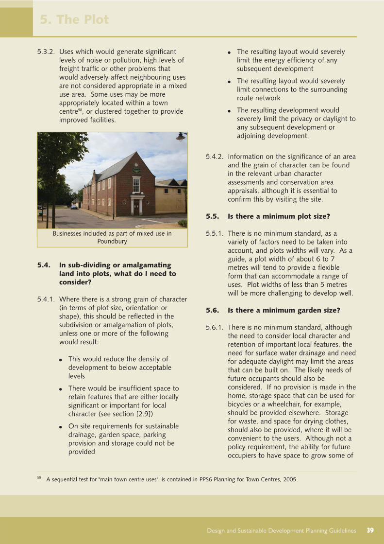
39Design and Sustainable Development Planning Guidelines
5.3.2. Uses which would generate significantlevels of noise or pollution, high levels offreight traffic or other problems thatwould adversely affect neighbouring usesare not considered appropriate in a mixeduse area. Some uses may be moreappropriately located within a towncentre58, or clustered together to provideimproved facilities.
5.4. In sub-dividing or amalgamatingland into plots, what do I need toconsider?
5.4.1. Where there is a strong grain of character(in terms of plot size, orientation orshape), this should be reflected in thesubdivision or amalgamation of plots,unless one or more of the followingwould result:
This would reduce the density ofdevelopment to below acceptablelevels
There would be insufficient space toretain features that are either locallysignificant or important for localcharacter (see section [2.9])
On site requirements for sustainabledrainage, garden space, parkingprovision and storage could not beprovided
The resulting layout would severelylimit the energy efficiency of anysubsequent development
The resulting layout would severelylimit connections to the surroundingroute network
The resulting development wouldseverely limit the privacy or daylight toany subsequent development oradjoining development.
5.4.2. Information on the significance of an areaand the grain of character can be foundin the relevant urban characterassessments and conservation areaappraisals, although it is essential toconfirm this by visiting the site.
5.5. Is there a minimum plot size?
5.5.1. There is no minimum standard, as avariety of factors need to be taken intoaccount, and plots widths will vary. As aguide, a plot width of about 6 to 7metres will tend to provide a flexibleform that can accommodate a range ofuses. Plot widths of less than 5 metreswill be more challenging to develop well.
5.6. Is there a minimum garden size?
5.6.1. There is no minimum standard, althoughthe need to consider local character andretention of important local features, theneed for surface water drainage and needfor adequate daylight may limit the areasthat can be built on. The likely needs offuture occupants should also beconsidered. If no provision is made in thehome, storage space that can be used forbicycles or a wheelchair, for example,should be provided elsewhere. Storagefor waste, and space for drying clothes,should also be provided, where it will beconvenient to the users. Although not apolicy requirement, the ability for futureoccupiers to have space to grow some of
5. The Plot
Businesses included as part of mixed use inPoundbury
58 A sequential test for "main town centre uses", is contained in PPS6 Planning for Town Centres, 2005.

40 Design and Sustainable Development Planning Guidelines
their own food does have widersustainability benefits as it reduces theneed to travel.
5.6.2. It is anticipated that some privateamenity open space will be needed formost homes, although the extent andproximity to public open space (includingallotments) will be considered. As ageneral principle, a depth of 10 metresfrom the rear of a property will normallyprovide privacy. Shorter distances may beacceptable depending on the design ofthe building. In the case of flats, sharedamenity areas may be considered,although some private space will normallybe sought. Homes with no privateamenity space will not normally beacceptable.
5.7. Do I need to say how the boundarywill be defined?
5.7.1. Boundary treatment may be key toreinforcing and defining the street,particularly where the building line is setback. In some areas, there is a consistentapproach to the type of boundarytreatment used, and this should berespected unless to continue it conflictswith other objectives. Clear boundarytreatment also helps indicate the extentof private ownership, and reducesopportunities for crime. For thesereasons, the type of boundary treatmentwill be considered in deciding planningapplications.
5.8. Is there a maximum height for wallsor hedges?
5.8.1. There is no set standard. However walls,hedges and fencing along the front edgesof a plot should normally be kept below1 metre in height to get a reasonablelevel of overlooking and surveillance ofpublic areas. If privacy is needed in reargardens, a 1.8 metre high boundary willnormally be sufficient to preventoverlooking from a neighbour's groundfloor or garden.
5. The Plot
Conflict between the need for privacy andoverlooking should be avoided
Different but continuous boundbury treatments,Dorchester
Industry in Sherborne

41Design and Sustainable Development Planning Guidelines
6.1. Things to consider
6.1.1. Although the council is trying to promotea way of living that is less reliant on theprivate car, the fact is that four in fivehouseholds in West Dorset have at leastone car, and this figure is even higher inthe more remote, rural locations.Adequate parking provision in the rightlocation is needed to ensure that cars areparked safely without dominating thestreet scene or creating a hazard topedestrians.
6.1.2. This chapter focuses on the differentways in which parking provision can bemade, and what needs to be consideredin deciding how parking is best provided.The main choices are between parkingon-street, in parking courtyards, or in theplot (either on driveways or garages). Acombination of these is more likely toprovide the best solution for largerschemes.
6.1.3. The next sections answer the followingfrequently asked questions:
6.2. Who do I need to involve?6.3. What do I need to consider if
providing parking on-street?6.4. What do I need to consider if
providing parking in parking courtyards?
6.5. What do I need to consider if providing parking in-curtilage (in the boundaries of the plot)?
6.1.4. It should be noted that Lifetime HomesStandard states that the distance from thecar parking space to the home should bekept to a minimum and should be level orgently sloping.
6.1.5. Information on surfacing and relateddesign matters is covered in Chapter 3(Streets, Paths and Open Spaces).
6.2. Who do I need to involve?
6.2.1. Advice on parking provision andconnections into the existing routenetwork can be obtained from thehighway authority (normally the countycouncil).
6.3. What do I need to consider ifproviding parking on-street?
6.3.1. On-street parking can provide aconvenient and efficient solution wherecars are well overlooked fromsurrounding houses. It can reduce theneed for visitor parking59, and provide atraffic-calming effect.
6.3.2. On-street parking needs to be reasonablynear to the homes it is intended for, andoverlooked by buildings that will providea degree of surveillance.
6.3.3. Parking bays should be incorporated intothe overall width of the street. To softenthe visual impact, instead of markingthese out by painted lines, considerationshould be given to the creative use ofpaving, trees or planting. Cars can beparked parallel to the kerb, or wherestreet width and safety allows, at anangle.
6.3.4. Large areas of hard surfacing toaccommodate ranks of parked cars areboth unattractive and may lead toproblems with surface water drainage.Landscaping treatment to soften orinterrupt the lines of cars can reduce thisimpact, providing such treatment wouldbe appropriate to the character of thelocal area.
6.3.5. Where cars are to be parked in a civicspace or square, generally there shouldbe no more than 15 spaces so as to notdominate the space. Larger parkingareas, if needed, will require careful
6. Parking Provision
59 research by Noble and Jenks (1996) has shown that visitor parking requirements generally coincide with the times when areasonable proportion of residents will be using their cars.

42 Design and Sustainable Development Planning Guidelines
landscaping, and pedestrian routes shouldbe clearly defined.
6.4. What do I need to consider ifproviding parking in parkingcourtyards?
6.4.1. Parking courtyards in perimeter blockscan provide the best solution in higherdensity, built-up areas where the extentof parking provision needed mayotherwise dominate the street scene.However, it needs careful design toensure that areas are safe, and theenjoyment of rear gardens not undulydiminished.
6.4.2. Parking courtyards will not be acceptableif they are insufficiently overlooked bybuildings, the parking provision does notrelate to the surrounding homes or itresults in large areas of tarmac (generallyno more than 10 spaces should be
clustered together). Any large areas ofhard surfacing (over 5 square metres)should be made permeable (so that watercan pass through it).
6.4.3. Where possible two access points shouldbe provided, forming a route across theblock. This should not be at the expenseof security, and care needs to be taken toensure that the entrance points do notsignificantly break up the street frontageand undermine its definition (see section[2.7]).
6.4.4. Homes placed in or on the entrance tothe courtyards are generally the bestsolution to ensure adequate overlooking.Where such properties are not on thehighway, provision should be made for arefuse collection area for bins at thekerbside.
6.4.5. The layout should allow sufficient spacefor some bays to be enlarged to 3.3metres width at a later date for disabledpeople to use, should the need arise.Garages should where possible beincorporated into the boundary of therear gardens of the homes they serve.Ranks of disassociated garaging shouldbe avoided.
6.4.6. Due to the shared nature of the space, itis important that a high quality of design,good landscaping and ongoingmaintenance are provided.
6. Parking Provision
On-street parking at Charlton Down
Consider landscaping within the parking coutryard
On-street parking in Sherborne

6.5. What do I need to consider ifproviding parking in-curtilage (insidethe boundaries of a plot)?
6.5.1. Parking within a plot is unlikely to makethe most efficient use of land, but may bethe only option available on smaller orindividual sites or when on-street orparking courtyards are not an option.
6.5.2. Where planning permission is required,in-curtilage parking will not be acceptableif the provision will be forward of thebuilding lines that help define the street,or if it would require alterations inground levels that would cause significantproblems for people with walkingdifficulties (see section [3.11]).
6.5.3. Any provision within the plot should bealongside or to the rear of the house (ifaccessed from the rear), set back fromthe building line. Sufficient room shouldbe allowed to enlarge the space to 3.3metres width for future disabled residents(for example, by providing a grass vergealongside the parking space), should theneed arise. Any large areas of hardsurfacing (over 5 square metres) shouldbe made permeable.
6.5.4. Car ports and garaging can be used toreduce the visual impact of cars andprovide increase security. However, it isimportant that adequate storageprovision is made within the property toensure that garages are used as intended.
43
6. Parking Provision
Design and Sustainable Development Planning Guidelines
Badly planned courtyards may be unwelcoming andneglected
Homes can provide some surveillance of parkingcourtyards
Without careful consideration, on-plot parking canbe intrusive in the street scene

44 Design and Sustainable Development Planning Guidelines
7.1. Things to consider:
7.1.1. In considering a new building, or anextension or alteration to an existingbuilding, thought needs to be given towhat is the most appropriate size andform, and how it is placed on the plot.These factors are key in helping definethe character of that building and itsidentity and harmony with the local area(and, in the case of extensions andalterations, how it impacts on the mainbuilding). It will also depend on:
The underlying block and plotstructure, and the need for outsidespace
Potential for energy efficiency(particularly reducing the need forartificial lighting and ventilation) anduse of renewable energy sources
Potential problems in relation toprivacy and daylight, both for theproposed building and how it mayaffect the amenity and enjoyment ofneighbouring properties
7.1.2. The character and visual interest of abuilding can depend on the symmetry (orasymmetry) and proportions of its doorsand windows, the materials and buildingtechniques used and any architecturaldetailing.
7.1.3. These guidelines do not override theneed for designers to understand thecharacter and identity of the local area,and take a creative approach to carry thisforward in new building works. There isno one standard solution that will work inall places, and every design shouldrespond to the uniqueness of the place inwhich it will be placed.
7.1.4. The next sections answer the followingfrequently asked questions.
7.2. Who do I need to involve?7.3. Are there any limitations on
building height?
7.4. Are there any limitations on building width or depth?
7.5. Is there a minimum distance needed between properties?
7.6. How far should the building be set back from the street?
7.7. How can I ensure the design takes advantage of solar gain andother measures that will naturallyreduce its running costs?
7.8. What types of wall are likely to be appropriate?
7.9. What roof forms and materials are likely to be appropriate?
7.10. Should my building have a chimney stack?
7.11. Should my building have an entrance porch?
7.12. Where should doors and windows be placed?
7.13. What types of doors and windows are likely to be appropriate?
7.14. What level and type of architectural detailing is appropriate?
7.15 What scope is there to improve the energy efficiency of a Listed Building?
7.16. Is there any specific guidance for shop fronts or advertisements?
7.17. Can I add security features (lighting, shutters, CCTV)?
7.18. Do I need planning permission to make minor alterations to my house?
7.19. Who is responsible for on-going maintenance?
7.2. Who do I need to involve?
7.2.1. Talk to local people who live near yoursite. If the building is to be a landmark,or lies within a town centre area, then abroader consultation exercise may beappropriate, including interested groupssuch as the local chamber of trade, andrepresentatives of disabled users.
7.2.2. Talk with experts who design for energyefficiency within buildings, to properly
7. The Building

45Design and Sustainable Development Planning Guidelines
consider all opportunities to reducing theamount of non-renewable energy used.
7.2.3. Information on local character is providedin the relevant urban characterassessments and conservation areaappraisals. Further advice may beobtained from the district council'sDevelopment Services Division.
7.3. Are there any limitations on buildingheight?
7.3.1. In a rural district such as West Dorset,building heights have tended to rangefrom two to three storeys, with somesingle and one and a half storeydwellings. Storey heights vary. Theheight will need to take into account thecharacter and period of the local area (orexisting building).
7.3.2. Decisions about building height shouldalso be made in relation to creatingstreet-building height ratios resulting ingood enclosure (see section [2.7]).
7.3.3. Buildings of four or more storeys (or theequivalent height) will generally only beacceptable in or adjoining town centrelocations, or where the building use is ofsignificant importance, or a landmark isneeded. Corner plots may be suited totaller, landmark buildings, although inresidential buildings the limited scope forprivate rooms and private garden spacemay mean this is not practical. Therelationship with nearby buildings (interms of local character, daylight andprivacy) may potentially limit height (seesections [2.9], [2.11] and [2.8]).
7.3.4. The appropriate height of an extensionwill very much depend on the characterof the original building, and also therelationship with its neighbours (both incharacter and in terms of daylight andprivacy). An extension should notdominate the original building (althoughextensions into the roof space or byadding another storey can sometimes besympathetically achieved). For buildingsthat are listed, as a general principle anyextension should be subservient in heightand character so as to not undermine thespecial interest of the building.
7.4. Are there any limitations on buildingwidth or depth?
7.4.1. The form of the building will oftendepend upon the plot shape andorientation. Narrow frontage, deep planforms are usually found in higher density,terraced areas where plot widths arenarrow. Shallow plan forms predominateelsewhere, and provide more variedstreet layouts with a mix of dwellingfrontages, garden and garage walls. Theneed for sufficient outdoor space, privacyand daylight can limit the width or depthof a building, although careful positioningwithin the plot and use of screening canhelp overcome some problems. Moreinformation on outdoor space is given insection [3]. Information on assessingprivacy and daylight is given in section[7.5]).
7. The Building
Sherborne’s roofscape shows a variety in buildingheights
Example of building heights and enclosure atCharlton Down

46 Design and Sustainable Development Planning Guidelines
7.5. Is there a minimum distance neededbetween properties?
7.5.1. There is no minimum distance stipulatedbetween neighbouring properties,however the need to ensure adequateprivacy and daylight is important, and thefollowing general principles provide someguidance.
7.5.2. 20 metres between facing buildings willnormally give good privacy between therear of buildings. Closer distances maybe possible where homes are not directlyfacing each other, or suitable screeningcan be achieved. Consideration can begiven to removing permitteddevelopment rights where futureextensions or alterations may causeconcern.
7.5.3. As a guide, if the shadow areas createdby new buildings or extensions extendover more than half of a window in anearby property, then there may be asignificant reduction in light entering thatroom60.
7.6. How far should the building be setback from the street?
7.6.1. Setting back buildings from the streetinfluences local character, the degree ofprivacy given to ground floor rooms, andthe ability to accommodate storage andservicing arrangements at the front of thebuilding.
7.6.2. A common building line createscontinuity of frontage which betterdefines the street space, and is generallythe preferred approach. Landmarkbuildings may either step forward or backfrom this line, to help reinforce theirprominence in the street or create a spacewhere, in some instances, activities maytake place. If there is significant variationlocally, other considerations, such as thepotential for more energy efficientlayouts, should be given greater weight.
7.6.3. The following table provides some furtherguidance:
7. The Building
Setback Main use Things to consider
None In high density, mixed use orpredominantly commercial areas where anintimate, enclosed street environment iswarranted and buildings can be servicedfrom the rear. Can be used to reducetraffic speeds where the buildings limitforward visibility along a street.
The design and positioning of doors andwindows where residential uses areproposed, to provide a reasonable degree ofprivacy. Raising the ground floor of abuilding above street level may be anappropriate solution provided it would notcompromise disabled access.
1 to 3m In medium to high density, mixed use orresidential areas.
The degree of privacy to front rooms andpossible pressure to accommodate parkingin the front garden area (see below).
3 to 5m In low to medium density, predominantlyresidential areas, where a small frontgarden is important to local character, or toreduce the noise and disturbance from abusy street.
Incorporate railings, hedge or otherboundary treatment to prevent the frontgardens from being used for parkingvehicles, which may undermine thecharacter and visual attractiveness of thearea.
60 Further guidance is given in Site Layout Planning for daylight and Sunlight - a Guide to Good Practice, 2002, BRE

47Design and Sustainable Development Planning Guidelines
7.7. How can I ensure the design takesadvantage of solar gain and othermeasures that will naturally reduceits running costs?
7.7.1. The orientation and design of buildings tobenefit from natural light and heat fromthe sun, and avoid overheating, is knownas passive solar design. Such design,which may not add much to the buildingcost, can make significant savings toheating and lighting costs during thebuilding's lifetime. Key factors toconsider in the design61 are:
Orientation and building form (shape)can be designed to capture heat andenergy from the sun effectively, byorientating the main glazed elevationand living rooms of a building to face
within 30° of south. Any solar orphotovoltaic panels that may be fixedto a building will also benefit fromsuch orientation. The possible effectof any overshadowing from nearbybuildings should also be taken intoaccount. Orientation is particularlyimportant for housing and schools,which can make effective use of solarheating and light
Building form can also provideopportunities from natural ventilation,which is particularly relevant to offices,schools and other public buildings, toreduce the need for air conditioning.The use of atria and roof lights canhelp also reduce the need for artificiallighting in large buildings. Houses andapartments should be designed toassist cross-ventilation where practical
Thermal mass and insulation can beused to absorb heat during the dayand release it slowly at night.Unheated spaces such asconservatories, green houses andgarages which are attached to theoutside of heated rooms can also actas thermal buffers
Window sizing and position can havean impact on the potential for solargain as well as daylight. Wherepossible, the size and number of northfacing windows should not beexcessive. Homes which only facenorth should be avoided.Conservatories and atria can help withnatural ventilation and heat collectionduring the spring and autumn, but theoverall benefits will be lost if they areheated for use during the winter.
7.7.2. The council has produced further advisoryinformation on sustainable or greentechnologies that is available on-line onwww.dorsetforyou.com and from thecouncil offices.
7. The Building
61 Key points summarised from Planning for Renewable Energy, A Companion Guide to PPS22, ODPM 2004, Section 5 onPassive Solar Design
No setback, with buildings on the pavement,Sherborne
Small front gardens provide some privacy, Dorchester

48 Design and Sustainable Development Planning Guidelines
7.8. What types of wall are likely to beappropriate?
7.8.1. The materials and types of walls usedshould be in keeping with, or helpenhance, local character. Additionalconsiderations include insulation, airtightness, and thermal mass. Evidencehas shown that it is possible to developenergy-efficient buildings using materialsthat are in keeping with the character ofWest Dorset. In areas known to beaffected by Radon gas, specific measuresmay also be required (advice on this canbe sought from the Building ControlTeam).
7. The Building
Industrial converted stone buildingwith modern metal roof, Sherborne
Flint and limestone walls,thatched roof, Stratton
Brick and slate or thatched roofs,Lyme Regis
Brick and rendered walls, slateroofs, Chickerell
Limestone walls and slate roof,Pyemore
Limestone walls andslate roof, Sherborne
Painted brick with timber-cladprojecting bay, Lyme Regis
Slate hanging, Lyme Regis

49Design and Sustainable Development Planning Guidelines
7.8.2. Examples of traditional wall finishes inWest Dorset include the use of:
7. The Building
Material Notes
Local LimestoneUsed as the principal building material and used incombination with brick, flint and chalk block.Traditionally sourced from local quarries (usuallywithin 10 miles), Portland and Purbeck stone aremore common in the south, whereas a goldenlimestone is more common around Sherborne.
Found throughout the district, generally morepredominant in rural areas. Traditionally laidas random rubble, coursed or uncoursed inlime mortar. Ashlar and dressed stonenormally limited to larger formal buildings.Pointing is normally full and flush.Reconstructed stone is generally unsuitable.
BrickPredominantly mottled brown or red in colour, withmore unusual colours (often a bi-product ofmanufacture) used for details around openings,horizontal 'band' courses around the buildings andvertical cornerstones or 'quoins'. Also used inchimney stacks. Painted brick occurs primarily in thewest.
Found throughout the district, generally morepredominant in urban areas. Brickstraditionally laid in Flemish, English, gardenwall or stretcher bond laid in lime mortar.Pointing is normally flush and does notproject beyond the surface of the wall. Newpainted brick is not normally encouraged.
Rendered masonryTraditionally a rich lime: sand mix, limewashed in arange of natural colours, often applied subsequentlyto provide additional weather protection. Is alsofound with the substrate or base 'grinning through'.Modern colour renders are spray applied ontoblockwork.
Found for example in Regency propertiesthroughout the district. Generally smoothsurface finish, self coloured, limewashed orpainted, coursed, lined out or scribed aroundapertures. Roughcast highly textured renderis less common. Bright colours are generallyunsuitable.
CobChalk cob, usually locally produced. Used in barns,dwellings and boundary wall treatment.
Found in Cerne Abbas, Piddle Valley andexceptional examples occurring in Bridportand Sherborne. Smooth, usually renderedsurface with rounded corners.
Flint & ChertMuch variety and variation. Materials often obtaineddirectly from site, used fully knapped (split down themiddle to reveal dark glossy flint centre), semiknapped and squared laid in courses and randomlywith small pieces (gallets of shards) embedded inmortar. Modern flint panels are prefabricated.
Chert found for example in Lyme Regis,whole beach pebbles in walling atCharmouth. Flint found along the BrideValley on the downland and in the chalkvalleys.
Timber claddingHorizontal and vertical timber boarding, with straightor natural, uneven (wany) edges.
Found primarily in Lyme Regis andCharmouth
Slate hangingDecorative and plain slates, Welsh or Cornish beneathprojecting bay windows but also on entire elevations.Shapes vary but usually are diamond, fishscale orrectangular nailed to battens.
Found primarily in Lyme Regis, particularlyalong Marine Parade and the west side ofBroad Street, and more occasionallyelsewhere.

50 Design and Sustainable Development Planning Guidelines
7.8.3. More information on local materials isprovided in the character assessments(see section [2.9])
7.8.4. Brick and block cavity wall construction,and traditional stone buildings generallyhave high thermal mass. Additionalthermal mass may be needed in lightweight buildings to avoid overheatingand reduce heat loss, to negate the needfor air conditioning in summer andventing of excess heat in the winter.Cellular glass and blown extrudedpolystyrene insulation should be avoidedbecause of their poor environmentalperformance62.
7.9. What roof forms and materials arelikely to be appropriate?
7.9.1. Traditional roofing materials are slate, claytiles including double Roman pantiles,thatch and stone slates. The design ofthe roof form should take into accountlocal character and neighbouringproperties, and give consideration towhat opportunities there may be to usesolar energy, the potential for futureextensions to the building, and likelyfuture maintenance requirements toensure the building's appearance does notdeteriorate significantly.
7.9.2. Flat and shallow-pitched roofs are nottypical of West Dorset, particularly not onresidential properties, and theirjustification needs careful consideration.Parapets can also create maintenanceproblems. There may be opportunities toaccommodate green roofs in the rightlocations. For example, green roofs havebeen permitted on new single storeydwellings at Lyme Regis where they blendinto the landscape.
7.9.3. Traditional roofs in West Dorset arepredominantly between 30° and 50° andare generally pitched, pyramidal, hipped,half-hipped or less commonly, mansard inform. Requirements for solar energy cannormally be met by most roof forms. Thestyle of eaves can vary greatly, althoughboxed eaves are not typically found inWest Dorset. Deeper eaves can helpreduce the impact of rain and providesome shading.
7.9.4. On an extension, the main considerationwill be how well the new roof wouldrelate to the existing building, taking intoaccount the building's form and character.Loft extensions that would alter the roofform should avoid creating rooflines thatappear overly bulky, and particular care isneeded where such developments mayset a precedent for nearby properties thatcumulatively would have an adverseimpact. Guidance on windows androoflights is given in section [7.13].
7. The Building
62 Green Guide to Specification, BRE, online version 2008 www.thegreenguide.org.uk
Consider how pitch relates to adjoining buildings Avoid overly bulky loft extensions

51Design and Sustainable Development Planning Guidelines
7.10. Should my building have a chimneystack?
7.10.1.Chimney stacks not only add interest andvariety to the skyline, but are purposebuilt flues for heating appliances and canfunction as vents for ventilation. As such,chimneys should be included in mostbuilding types, and designed to beoperational. Throughout the district,chimneys are predominantly built ofbrick. The introduction of GRP (GlassReinforced Plastic) pre-formed chimneystacks or similar products will not bepermitted.
7.10.2.The design and placing of the chimneycan reflect local character. As a generalprinciple, avoid understated, small, thinchimneys, which are unconvincing andfail to make a meaningful contribution tothe design. Detailing at the top of thechimneystack and the type of chimneypots used can help prevent damppenetration and add individuality to thedesign.
7.11. Should my building have anentrance porch?
7.11.1.Entrance porches provide shelter from theweather, act as draught lobbies to reduceheat loss from buildings, and can add tothe character of a building. The porcharea can also be designed to providevaluable storage space within its flankwalls without compromising security. Incommercial buildings, particularly shops,where the building is directly on thepavement, the door can be recessed,providing relief to the shop front as wellas shelter.
7.11.2.A porch may not be appropriate ifbuildings in the local area do not havethem and there is little local variation instyle. Where a porch is appropriate, itsscale, form and materials should be inkeeping with the building, and the localcharacter of the area. Other methods,such as the use of painted timberdoorcases or stone canopies on consolebrackets, may be considered as a meansof enhancing the main entrance to thehouse and adding prestige to thedoorway, where these would be suitableto the overall design of the property.'Stick on' mouldings and features that arenot built to last should be avoided.
7. The Building
Chimneys can provide interest, Bridport
Contemporary chimney vents in new build,Sherborne Porch covers in Sherborne

52 Design and Sustainable Development Planning Guidelines
7.12. Where should doors and windowsbe placed?
7.12.1.Doors and windows provide natural lightand ventilation. Their design andplacement can help establish a vertical orhorizontal emphasis or pattern that isvisually attractive and locally distinctive.This should also take into account:
disabled users needs (see section[7.13]).
fire exit/safety requirements
the need for natural surveillance andprivacy
opportunities to increase the energyefficiency of the building.
7.13. What types of doors and windowsare likely to be appropriate?
7.13.1.The main traditional material for doorsand windows in West Dorset is timber.Modern UPVC windows are morereflective (and more prominent) in widerviews, and due to their greater bulk, theydo not reflect the character of traditionalwindows in historic areas. They have alsonot been proven to last as long asproperly maintained high quality woodenframes63. Powder coated aluminium cladsoftwood windows and heavier (over1.08 kilograms to the metre) powdercoated aluminium windows performbadly in terms of their widerenvironmental impact64. It is important toconsider the likely future maintenancerequirements, to ensure that the qualityand appearance of the scheme can besustained.
7.13.2.The opening size and proportions shouldtake into account the character of thebuilding and the local area, theopportunities to utilise solar energywithout overheating, and the need foradequate levels of daylight within thebuilding. There are a variety oftraditional window styles in the district.Advances in technology and glassproduction means that glass has becomea much more versatile buildingcomponent than it has in the past.However, large undivided areas of glassare not in keeping with local character inWest Dorset and should as a generalprinciple be avoided on elevations seenfrom the street (with the exception ofshopfronts). In alterations to an existingbuilding, or an extension to it, new doorsand windows should respect thecharacter of the original building and thedesign of its existing doors and windows.
7. The Building
63 research by English Heritage has shown that over the lifetime of a typical mortgage, the installation and maintenance costsof high quality timber windows actually works out cheaper than UPVC (Conservation Bulletin, Issue 14, June 1991Framing Opinions supplement)
64 Green Guide to Specification, BRE, online version 2008 www.thegreenguide.org.uk
a) comparable designs show how windows in thesehomes...
b)...could have been better aligned and defined

53Design and Sustainable Development Planning Guidelines
7.13.3.Secondary, double and triple glazing toimprove energy efficiency should bepossible on most buildings. Fittingsecondary glazed units is reversible andmay provide the most appropriatesolution for protecting the character ofhistoric buildings.
7.13.4.The extent to which a window is recessedwithin the wall is another key factor.Traditionally windows placed in solidmasonry walls are set back from, ratherthan flush to, the wall. This gives thebuilding more character (through theshadow lines created) and also has betterweather protection and provision forshading.
7.13.5.South facing windows should bedesigned to avoid the need for aninternal cooling system. Carefulconsideration should be given to theappearance of external blinds or shuttersused on street elevations.
7.13.6.The use of dormers within loft extensionsshould respect the proportion of theexisting window openings and scale ofthe property by being narrower andshorter to avoid the dormer dominatingand unbalancing the roofscape. The useof rooflights (that sit flush with theexisting slope of the roof) in historicbuilding should where practicable be onthe rear roofslope and use of metalrooflights that are similar to traditionalcast iron rooflights, are preferred.
7.13.7.To meet disabled needs, it is importantthat the threshold to all doorways is level.The Lifetime Homes Standard requiresthat the route from the car parking spaceinto the home should be level or gentlysloping, and this applies to all parkingspaces provided. Steps are onlyacceptable on an alternative or secondaryroute (in accordance with Part M of theBuilding Regulations). Thresholds higherthan 15 millimetres should be avoided.UPVC doors with high thresholds cannotbe easily adapted for wheelchair accesswithout complete replacement of thedoor frame, and therefore should beavoided. Doors should have a minimumclear opening width of 750 millimetres(800 millimetres at the front entrance) tocomply with Building Regulations forDisabled Access. Windows and doorsshould be easy to open for disabled users,and it is advisable that the locks meetcurrent security standards, and
7. The Building
Traditional blind mechanism
A hotchpotch of loft conversion styles
Sympathetic rooflights, Pyemore

54 Design and Sustainable Development Planning Guidelines
consideration given to using doors andwindows that are certified to offerenhanced resistance to intrusion65.Window sills should be no more than 800millimetres above internal ground floorlevel to allow for better views out forthose confined to chairs where this canbe achieved without compromising localcharacter or, in the case of an extension,the character of the original building, andin accordance with Building Regulations.Frameless glass doors should be avoidedas they are dangerous for the young andpeople with partial sight.
7.14. What level and type of architecturaldetailing is appropriate?
7.14.1.The level and richness of detailing shouldbe appropriate to the status of thebuilding within the street, and localcharacter. In the case of extensions, thedetailing should match or respect that onthe original building.
7.14.2.Quirky or interesting features providebuildings with a degree of individuality.However, they should not result in acluttered appearance, be out ofproportion with the rest of the building,or be difficult to maintain to a goodstandard. Local examples include:
Loading doors and hoists, particularlyin old stores or warehouses
Verandas, bay windows, first floorbalconies
Gate piers
Slate hanging on projecting bays
Carved or decorative barge boards
Decorative ridge tiles
Decorative fanlights
Weather vanes
7.14.3.Where signs are needed, these providean opportunity for creativity, for exampleby using symbols to portray the type ofgoods or service the shop provides.Projecting signs are traditionally hung atright angles to the fascia, from decorativemetal fixings. Clutter through theproliferation of signs and other featuresshould be avoided. Projecting box signsare not appropriate in historic areas.
7.14.4.'Stick on' mouldings and features that arenot built to last should be avoided.
65 Compliance with 'secured by design' New Homes Part 2 (Physical Security) qualifies for percentage points under the Codefor Sustainable homes Further details can be obtained at www.securedbydesign.com
Example of detailing at Poundbury
Example of detailing at Charlton Down
Lack of any detailing or interest is unacceptable
7. The Building

7.15. What scope is there to improve theenergy efficiency of a ListedBuilding?
7.15.1.The range of Listed Buildings are vast,varying from 12th Century or olderchurches to mansions, simple cottagesand barns. Because of their long lifespans, many would be consideredinherently sustainable. There is alsogeneral consensus that many ListedBuildings can sustain some degree ofsensitive alteration. However, becauseeven minor works which may seem oflittle importance can be very destructiveto a building's special interest, each casewill need to be considered on its ownmerits.
7.15.2.Experience has shown that, as a generalguide, the types of improvement that are
most likely to be effective and compatiblewith a Listed Building are as follows:
Improved draught proofing
Increased insulation
Installation of secondary glazing
Installation of an energy efficientboiler
Installation of solar panels orphotovoltaics
Installation of a ground heat sourcepump
7.15.3.English Heritage set out the followingtests for assessing the installation ofsmall-scale renewable energy systemsattached to a listed building66.
Significant parts of the historic fabricwill not be irreversibly damaged andany impact on it will be limited
Views of the building would not becompromised (views from publicplaces are particularly important)
No practical alternatives exist thatwould not require intervention in thehistoric fabric
Efforts have been made to lessenimpact by design, location, choice ofmaterials, colours etc
7.15.4.The council advises that anyoneconsidering how best to improve theirListed Building obtains expert advice froma suitably qualified architect or surveyor.The council has produced further advisoryinformation on sustainable or greentechnologies that is available on-line andfrom the council offices.
55Design and Sustainable Development Planning Guidelines
66 Further advice and case study examples are included in the publication Microgeneration in the Historic Environment, EnglishHeritage, 2008
Example of a local traditional sign,Bridport
Example of a traditionalhoist, Dorchester
Hanging sign,Sherborne
7. The Building
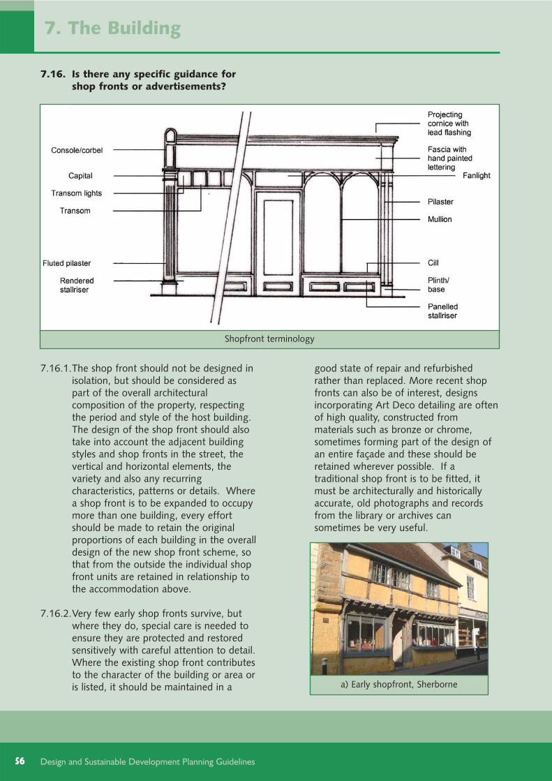
56
7.16. Is there any specific guidance forshop fronts or advertisements?
7.16.1.The shop front should not be designed inisolation, but should be considered aspart of the overall architecturalcomposition of the property, respectingthe period and style of the host building.The design of the shop front should alsotake into account the adjacent buildingstyles and shop fronts in the street, thevertical and horizontal elements, thevariety and also any recurringcharacteristics, patterns or details. Wherea shop front is to be expanded to occupymore than one building, every effortshould be made to retain the originalproportions of each building in the overalldesign of the new shop front scheme, sothat from the outside the individual shopfront units are retained in relationship tothe accommodation above.
7.16.2.Very few early shop fronts survive, butwhere they do, special care is needed toensure they are protected and restoredsensitively with careful attention to detail.Where the existing shop front contributesto the character of the building or area oris listed, it should be maintained in a
good state of repair and refurbished rather than replaced. More recent shopfronts can also be of interest, designsincorporating Art Deco detailing are oftenof high quality, constructed frommaterials such as bronze or chrome,sometimes forming part of the design ofan entire façade and these should beretained wherever possible. If atraditional shop front is to be fitted, itmust be architecturally and historicallyaccurate, old photographs and recordsfrom the library or archives cansometimes be very useful.
Design and Sustainable Development Planning Guidelines
Shopfront terminology
a) Early shopfront, Sherborne
7. The Building

7.16.3.Fascias should be kept in proportion tothe shop front and placed well below firstfloor window sills. As a general principle,a depth of around 40 centimetres isnormally about right, but this will dependupon the scale and proportions of thebuilding to which it is applied. Overlydeep fascias should be avoided.Excessive amounts of lettering and signson the fascia or display windows whichwould clutter and block the shop frontdesign and window displays should beavoided.
7.16.4.In circumstances where lettering isattached directly to the building (in thecase of there being no shop front orfascia board) provision should be madefor attaching and re-attaching signs orletters that does not interfere with thefabric of the building. This enables thename or style to be changed withoutcausing irreparable damage to thebuilding. It is sometimes useful to use asingle fixed bar to attach letters to avoiddamaging the wall surface. Signs may
57Design and Sustainable Development Planning Guidelines
b) Georgian Shopfront, Beaminster
c) Regency shopfront, Bridport
d) Victorian shopfront, Dorchester
e) Edwardian Shopfront, Sherborne
f) Art Deco modern shopfront, Sherborne
g) Contemporary shopfront, Beaminster
7. The Building
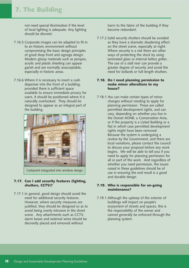
58
not need special illumination if the levelof local lighting is adequate. Any lightingshould be discreet.
7.16.5.Corporate images can be adapted to fit into an historic environment withoutcompromising the basic design principlesof good shop front and signage design.Modern glossy materials such as perspex,acrylic and plastic sheeting can appeargarish and are normally unacceptable,especially in historic areas.
7.16.6.Where it is necessary to insert a cashdispenser into the front of a building,provided there is sufficient spaceavailable to ensure immediate privacy forusers, it should be positioned where it isnaturally overlooked. They should bedesigned to appear as an integral part ofthe building.
7.17. Can I add security features (lighting,shutters, CCTV)?
7.17.1.In general, good design should avoid theneed for additional security features.However, where security measures arejustified, they should be designed so as toavoid being overly intrusive in the streetscene. Any attachments such as CCTV,alarm boxes and external wires should bediscreetly placed and removed without
harm to the fabric of the building if theybecome redundant.
7.17.2.Solid security shutters should be avoidedas they have a dramatic deadening effecton the street scene, especially at night.Where security is a risk there are otherways of protecting the stock by usinglaminated glass or internal lattice grilles. .The use of a stall riser can provide agreater degree of security and avoid theneed for bollards or full-length shutters.
7.18. Do I need planning permission tomake minor alterations to myhouse?
7.18.1.You can make certain types of minorchanges without needing to apply forplanning permission. These are calledpermitted development rights, and canvary, depending on whether you live inthe Dorset AONB, a Conservation Area,or if the property is a Listed Building or aflat in which case permitted developmentrights might have been removed.Because the system is undergoing areview by the Government, and there arelocal variations, please contact the councilto discuss your proposal before any workbegins. We will be able to tell you if youneed to apply for planning permission forall or part of the work. And regardless ofwhether you need permission, the issuesraised in these guidelines should be ofuse in ensuring the end result is a goodand durable design.
7.19. Who is responsible for on-goingmaintenance?
7.19.1.Although the upkeep of the exterior ofbuildings will impact on people'senjoyment of streets and spaces, this isthe responsibility of the owner andcannot generally be enforced through theplanning system.
Design and Sustainable Development Planning Guidelines
Cashpoint integrated into window design
7. The Building

59Design and Sustainable Development Planning Guidelines
8. Internal Layout
67 current British Standard BS8300 minimum size
8.1. Things to consider
8.1.1. The internal layout of a building is notgenerally controlled through planning,however some issues do affect theexternal appearance and design of abuilding. Because the council wishes toencourage good practice (which may gobeyond the minimum standards required),advice on internal layouts is contained inthis chapter.
8.1.2. The next sections answer the followingfrequently asked questions:
8.2. Who do I need to involve?8.3. Does it matter how I subdivide a
house?8.4. Does it matter how the rooms are
distributed?8.5. What else do I need to consider?
8.2. Who do I need to involve?
8.2.1. Because the design should ensure thatthe building is accessible to everyone,early consultation with disabledrepresentatives is advised.
8.2.2. Information on building regulations maybe obtained from the district council'sBuilding Control Service.
8.3. Does it matter how I subdivide ahouse?
8.3.1. The subdivision of homes will have abearing on the overall occupancy leveland internal room sizes. Homes withsmall rooms may in the longer term beless sustainable. This is because theyhave limited scope to support the needsof growing families or people wishing towork from home. They may also bedifficult to adapt to meet Lifetime Homesrequirements. Whilst the council wishesto see a variety of home sizes, as ageneral principle the internal floor areashould be at least the following size to
accommodate a certain number ofbedrooms:
over 50 square metres internal floor area= 1 bedroom home
over 65 square metres internal floor area = 2 bedroom home
over 90 square metres internal floor area = 3 bedroom home
over 105 square metres internal floorarea = 4 bedroom home
Consideration should be given toensuring the main living rooms are placedwhere they may contribute to creatingactive and overlooked public areas, andideally benefit from passive solar design(see section [7.7]).
8.3.2. Sufficient turning space should beprovided in the lobby area at the mainentrance, and within the main livingareas, for wheelchair users. Living roomsshould be a minimum of 3.6 metres by4.2 metres67.
8.3.3. As stairlifts may need to be installed fordisabled users, the design of the staircaseshould be carefully considered, withsuitable width and bulkhead height toaccommodate stairlifts, and space at thetop and bottom for safe use. Staircasesthat are straight can be more readily havestairlifts fitted, and the stairlifts can be re-used in similar properties. Wherepossible, the opportunity to install aplatform lift from a ground floor livingspace to a bedroom area should beencouraged, as in some cases a disabledor elderly person cannot regularly transferon and off a stairlift.
8.3.4. Bathrooms should be designed toaccommodate disabled users. Theyshould be of sufficient size to allow forwheelchair transfers on to a bath aid, and
60 Design and Sustainable Development Planning Guidelines
give carers space to attend to their needs.
8.3.5. Where possible, space should be providedat the main entrance point that can beused to store bicycles, or used for a pram,buggy, wheelchair or electric mobilityscooter. Alternatively, provision may bemade within the plot (see section [5.4]).Consideration will also need to be givento the storage of waste for recycling anddisposal.
8.4. Does it matter how the rooms aredistributed?
8.4.1. The distribution of different room typesshould take into account the need forprivacy and daylight. The least privaterooms (such as living rooms) are moreappropriately placed at the front of thebuilding, with more private rooms (suchas bedrooms and bathrooms) that are lesslikely to contribute to overlooking bettersuited to the backs.
8.4.2. For properties without permanent,entrance level bedrooms, a space atentrance level that can be used as a bed-space temporarily should be included(and with good design this may alsoprovide the home office credits in thecode for sustainable homes68). Having aground floor room with a toilet is arequirement of current BuildingRegulations.
8.5. What else do I need to consider?
8.5.1. Consideration should be given to howtechnologies that could potentially helpdisabled or other user be retro fitted intohomes. For example, skirting ducts couldbe designed to allow new cabling to beinstalled with minimal disruption.
8. Internal Layout
68 Category Ene 9 - Home Office.
9.1. What we will consider
9.1.1. To ensure policies continue to beeffective, we need to understand whetherthey work effectively, and consider whatimplications there may be in light ofchanges in overarching planning policy or,indeed, changes in building practice andtechnology, the state of the environmentand the national and local economy.
9.1.2. The council produces an AnnualMonitoring Report which reports on dataand trends which may influence planningpolicy, and examines the need for reviewor alteration. The sustainability appraisalof these planning guidelines has identifieda number of indicators to assist inmonitoring its effectiveness and anysignificant adverse impacts.
9.1.3. This document gives more details for thepolicies in the West Dorset District LocalPlan 2006. When new planning policy isintroduced (the Core Strategy), the designguidelines will need to be reviewed tomake sure they comply with the newpolicies. As a result, this document maybe changed. If the Government does notmake the anticipated changes to buildingregulations to help progress towardszero-carbon development, this documentwill also need updating.
9.1.4. Any proposes to change this documentwill be publicised and shown onwww.dorsetforyou.com/ldf/west.
9. Monitoring and Review

61Design and Sustainable Development Planning Guidelines
The following is a list of documents and papers that provide useful background reading, and may havebeen footnoted in the main document.
Active Design, Sport England, 2007, http://www.sportengland.org/active-design-final.pdf
Adapting to climate change impacts - a good practice guide for sustainable communities,DEFRA and the Three Regions Climate Change Group, 2006,http://www.defra.gov.uk/science/project_data/DocumentLibrary/GA01073/GA01073_4083_FRA.pdf
Better Places to Live by Design: A Companion Guide to PPG3, DCLG, 2001,http://www.communities.gov.uk/publications/planningandbuilding/betterplaces
Biodiversity By Design, A Guide For Sustainable Communities, Town and County PlanningAssociation, 2004, http://www.tcpa.org.uk/publications.asp
Building for Life - Evaluating Housing Proposals Step by Step, CABE, 2008,http://www.buildingforlife.org/
Building Health - Creating and Enhancing Places for Healthy, Active Lives, National HeartForum in partnership with Living Streets and CABE, 2007,http://www.heartforum.org.uk/publications_nhfreportsarchive_pub_buildhealth.aspx
Building Regulations (parts A - P), (date varies according to part), DCLGhttp://www.planningportal.gov.uk/england/professionals/en/1115314110382.html
By Design, Urban design in the planning system: towards better practice, CABE and DETR,2000 http://www.cabe.org.uk/AssetLibrary/1818.pdf
Climate Change Adaption By Design, A Guide For Sustainable Communities, Town and CountyPlanning Association, 2007, http://www.tcpa.org.uk/publications.asp
Code for Sustainable Homes: Technical guide (dates vary as reviewed yearly), DCLG,http://www.communities.gov.uk/publications/planningandbuilding/codeguide
Dorset Rural Roads Protocol, Dorset County Council, April 2008,http://www.dorsetforyou.com/ruralroads
Energy conservation in traditional buildings, English Heritage, 2008,http://www.climatechangeandyourhome.org.uk/live/content_pdfs/94.pdf
Green Guide to Specification, BRE, online version www.thegreenguide.org.uk.
Inclusive Mobility, DfT, 2005,http://www.dft.gov.uk/transportforyou/access/peti/inclusivemobility
Lifetime Homes, 16 design standards developed in the 1990s by the Joseph RowntreeFoundation Lifetime Homes Group, www.lifetimehomes.org.uk andwww.jrf.org.uk/knowledge/findings/foundations/2.asp
Manual for Streets, DfT, 2007, http://www.dft.gov.uk/pgr/sustainable/manforstreets/
Places, Homes, People - Policy Guidance - English Partnerships' Quality Standards, EnglishPartnerships, 2007, http://www.englishpartnerships.co.uk/publications.htm#bestpractice
Planning Policy Statement 1 Delivering Sustainable Development, DCLG, 2005,http://www.communities.gov.uk/planningandbuilding/planning/planningpolicyguidance/planningpolicystatements/planningpolicystatements/pps1/
Appendix 1: Additional reading

62 Design and Sustainable Development Planning Guidelines
Planning Policy Statement: Planning and climate change - supplement to Planning PolicyStatement 1, DCLG, 2007http://www.communities.gov.uk/publications/planningandbuilding/ppsclimatechange
Planning for Renewable Energy, A Companion Guide to PPS22, ODPM 2004,http://www.communities.gov.uk/publications/planningandbuilding/planningrenewable
Safer Places - the Planning System and Crime Prevention, ODPM and Home Office, 2004,http://www.communities.gov.uk/documents/planningandbuilding/pdf/147627.pdf
Secured by Design: Design Guides and Publications, ACPO Crime Prevention Initiatives,http://www.securedbydesign.com/guides/index.aspx
Streets for All South West, English Heritage, 2005, http://www.english-heritage.org.uk/server/show/nav.10766
Sustainable design, climate change and the built environment, CABE, 2007,http://www.cabe.org.uk/AssetLibrary/10661.pdf
Sustainable Energy By Design, A TCPA 'By Design' Guide For Sustainable Communities, Townand County Planning Association, 2006, http://www.tcpa.org.uk/publications.asp
Urban Design Compendium 1: Urban Design Principles, English Partnerships and The HousingCorporation, 2000, http://www.englishpartnerships.co.uk/qualityandinnovationpublications.htm
Appendix 1: Additional reading

63Design and Sustainable Development Planning Guidelines
The Code for Sustainable Homes was firstpublished in April 2007. From May 2008 allnew homes being sold will have a code rating(or a nil-rated certificate in those circumstanceswhere the code has not been built to arecognised code standard). It means that homebuilders can clearly demonstrate thesustainability performance of their homes, anddifferentiate themselves from poorer designs.
The code measures the sustainability of a homeagainst nine design categories. Each categoryincludes a number of performance targets,against which the home can score credits, whichwhen a weighting factor is applied provide apercentage point score. These targets are moredemanding than current Building Regulations orother legislation, but are proven to be technicallyfeasible and deliverable.
Appendix 2: The code for sustainable homes and breeam
Category Performance targets Mandatory % Points
Energy and carbonemissions
Dwelling emission rate Targets for each level 18.83Building fabric 2.51Internal lighting 2.51Drying space 1.26Energy labelled white goods 2.51External lighting 2.51Low or Zero Carbon technologies 2.51Cycle storage 2.51Home office 1.26
WaterInternal water use Targets for each level 7.50External water use 1.50
MaterialsEnvironmental impact Basic level 4.50Responsibly sourced building elements 1.80Responsibly sourced finishing elements 0.90
Surface water run-off
Management of run-off Basic level 1.10Flood risk 1.10
WasteStorage of household waste Basic level 3.66Construction waste management Basic level 1.83Composting 0.91
PollutionGlobal warming potential of insulants 0.70NOx emissions 2.10
Heath andwellbeing
Daylighting 3.50Sound insulation 4.67Private space 1.17Lifetime homes Level 6 (reducing to 3) 4.67
Management
Home user guide 3.33Considerate constructors scheme 2.22Construction site impacts 2.22Security 2.22
Ecology
Ecological value of site 1.33Ecological enhancement 1.33Protection of ecological features 1.33Change in ecological value of site 5.33Building footprint 2.67

64 Design and Sustainable Development Planning Guidelines
Subject to the mandatory requirements, properties are rated as follows:
at least 36 percentage points = Code Level 1 ( )
10% more energy efficient and 20% more water efficient than most new homes
at least 48 percentage points = Code Level 2 ( )
at least 57 percentage points = Code Level 3 ( )
25% more energy efficient than most new homes
at least 68 percentage points = Code Level 4 ( )
at least 84 percentage points = Code Level 5 ( )
at least 90 percentage points = Code Level 6 ( )
carbon-zero (the net carbon emissions over the course of the year would be zero).
The rating for each home is done by an independent, trained and accredited assessor. An initial rating isgiven at the design stage, and a post-completion check is carried out to confirm the code rating.
BREEAM (Building Research Establishment's Environmental Assessment Method) sets the standard forbest practice in sustainable design for non-residential buildings, and the BREEAM Ecohomes can be usedto assess major alterations to homes. There are specific manuals for a range of building types, includingoffices, shops, schools and industrial premises. There is also a 'bespoke' manual for building types thatdo not fall within the categories covered.
A BREEAM assessment is very similar to the Code for Sustainable Homes, in that credits are awarded innine categories according to performance. These credits are then added together to produce a singleoverall score on a scale of Pass, Good, Very Good, Excellent and Outstanding. There are variousmandatory requirements covering a range of themes, particularly for achieving a 'Very Good' rating orhigher.
For further information
Code: visit the DCLG websitehttp://www.communities.gov.uk/planningandbuilding/buildingregulations/legislation/englandwales/codesustainable/ or email the helpdesk [email protected]: visit the website www.breeam.org or email the helpdesk [email protected].
Appendix 2: The code for sustainable homes and breeam

65Design and Sustainable Development Planning Guidelines

West Dorset District CouncilStratton House, 58/60 High West Street
Dorchester, Dorset DT1 1UZ
Tel: 01305 251010 Fax: 01305 251481Typetalk calls welcome
www.dorsetforyou.com
Working for West Dorset