surface instruments cloud cover validation using
TRANSCRIPT

Cloud Cover Validation usingSurface Instruments
R. Welch1, T. Berendes1, D. Berendes1,E. Dutton2, T. Uttal3, P. Minnett4 , E. Clothiaux5
1 Dept. of Atmospheric Sciences, Univ. of Alabama in Huntsville2 NOAA/Climate Monitoring and Diagnostics Laboratory3 NOAA/Environmental Technology Laboratory4 Rosenstiel School of Marine and Atmospheric Science, Univ. of Miami5 Dept. of Meteorology, Pennsylvania State University

Cloud Mask Evaluation
λ Visual using IVICS - subjectiveλ Quick feedback for training processλ Analyst interpretation may be biased
λ NNW accuracyλ Independent samplesλ Hard numbersλ Analyst may be unable to discern cirrus
and sub-resolution cumulus

Cloud Mask Evaluation cont.
λ “Validation” using surface instrumentsλ Data independent of satelliteλ Minimal analyst interpretationλ Multiple instruments and sitesλ Applicable to any cloud masking algorithmλ Expandable databaseλ Batch mode processingλ Integrated with IVICS - user friendly

Neural Network ClassificationAccuracy
Accuracy (%)
9992Sunglint
9694Global
9796Polar
Cloud OnlyOverallRegion

Surface Validation Sitesλ Atmospheric Radiation Measurement Program (ARM)
λ Explorer of the Seas cruise ship - S.E. Atlantic,Caribbean Sea
Cruise AreaCruise Area

ARM Cloud Instruments
Vaisala Ceilometer (VCEIL)
Micropulse Lidar(MPL)
Millimeter WavelengthCloud Radar (MMCR)
Whole Sky Imager(WSI)
λ Southern Great Plains (SGP)λ Aug 2000 – Jun 2002 VCEIL, MPL, WSI
λ North Slope of Alaska (NSA)λ Aug 2000 – Jun 2002 VCEIL, MPL, WSIλ Jan – Dec 2000 MMCR (Uttal processed)

Cruise Ship Instruments
λ Vaisala Ceilometer, Total Sky Imager (Jan – June 2001)

Surface Instrument Dataλ Cloud Cover
λ Vaisala Ceilometer (VCEIL)λ Micropulse Lidar (MPL)λ Millimeter Wavelength Cloud Radar (MMCR)λ Active Remote Sensing of Clouds (ARSCL)λ Whole / Total sky imager (WSI / TSI)
λ Estimated optical depth (EOD) - NormalIncidence Pyrheliometer (NIP)
λ Cloud height - VCEIL, MPL, ARSCL

Validation of Cloud Maskλ MODIS data over surface sites
λ Over 2000 images Aug 2000 – May 2002λ Extract pixels for 5, 10, 15 km site radiiλ Classify pixels and create cloud maskλ Compute cloud cover (spatial)
λ Surface cloud cover instrument dataλ Match overpass time +/- 5, 10, 15, and 20 minλ Compute cloud cover over time interval (WSI and
TSI computed spatially at overpass time )
λ Intercompare and analyze using height andEOD data (NIP)


Sat Mask 100
VCEIL 100MPL 100MMCR 100ARSCL 100
EOD >2.1
Sat Mask 52
VCEIL 100MPL 100MMCR 100ARSCL 100
EOD 1.2

Sat Mask 0
VCEIL 0MPL 71WSI 1MMCR 100ARSCL 0
EOD 0.3
Sat Mask 100
VCEIL 0MPL 50WSI 3ARSCL 0
EOD 0.3
SZ 70VZ 55

CERESUAH
CERESUAH

CERESUAH

CERESUAH


Summaryλ Neural network cloud accuracy > 96 %λ NSA cloud cover intercomparison
λ VCEIL, MPL, MMCR agree with mask 72 – 79 %λ ARSCL composite better, agrees 80 – 82 %λ WSI best agreement 83 %
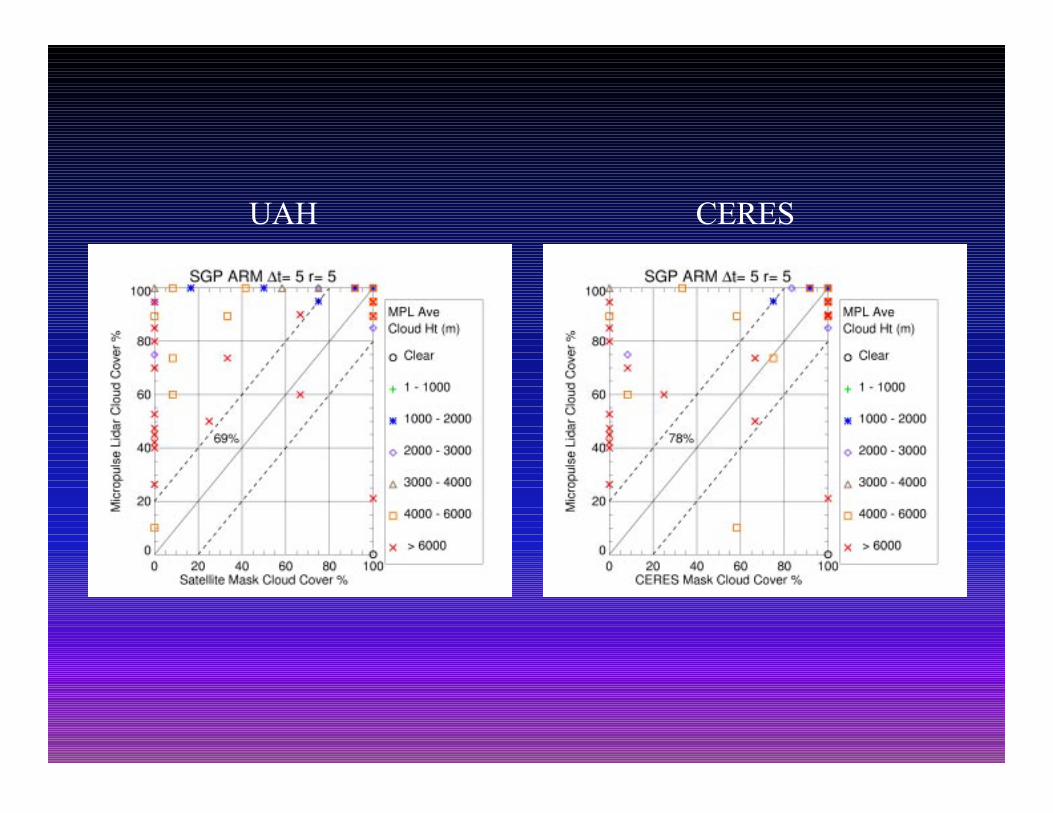
λ SGP cloud cover intercomparisonλ Lower agreement with satellite, 38 – 76 %λ MPL worst 38 % - too much cirrusλ WSI best 76 %
λ Cruise ship - preliminaryλ VCEIL 53 %, TSI 68 %

Conclusionλ Some surface Instruments find more cloud
λ MPL and MMCR more sensitive to thin (cirrus)λ Satellite mask may be missing some cirrus and
sub-resolution cumulusλ Nonhydrometeors detected as cloud?
λ Composite ARSCL data improves agreementif component data is good
λ WSI and TSI provide best agreementλ Validation requires multiple instruments / dataλ CERES agrees well with ground data at SGPλ CERES and our mask agree to 86 % at SGP
Future Work
λ Revise classifier to fix problem areasλ Validation paper submitted to JGRλ Refine interpretation of instrument dataλ Distribute database and codeλ Free IVICS visualization software
λ http://www.nsstc.uah.edu/ivics