surficial geology and interpretive geologic cross section...
TRANSCRIPT

!
!
!
!
!
!
!
!
!
!
!.
!.
!.
!.
!.
!.
!.
!.
!. !.
!.
!.
!.
!.
NORTH PLATTE
28 27 26 25 30 29 28 27
34333231363534
33
4 3 2 1 6 5 4
9871211109
16 15 1413 18 17 16 15
2221201924232221
28 27 26 25 30 29 2827
34333136353433
4 3 2 1 6 5 4 3
32
10
3
3080
3000
3100
3000
3000
3040
3100
3100
3000
3060 300
0
3000
3000
3000
2920
2940
29603000
3000
3000
3000
2960
3060
3000
3000
2980
2980
2920
2900
29002900
3000
3000
3000 3000
2900
2860
3000
2900
2875
2850
3000
2900 2900
2855
2870
2860
2875
2880
2850
2845
2840
2840
2850
2845
2840
2835
2835
2840
2850
2835
2830
2830
2835
2840
2900
3000
294029002860
2835 2860
2900
2825
2830
2840
2825 2840
2860
2900
2825
2825
2825
2840
2845
2840
2835
2835
2845
2850
2850
2840
2835
2830
2825
2825
2825
28202820
2820
2815
2810
2825
2815
2810
2810
2805
2805
2800
2825
2820
2815
2845
2840
2850
2835
2845
2845
2840
2835
2830
2825
2825
2820
2820
2815
2805
2800
2800
2800
2805
2810
2810
2815
2825
2830
2830
2840
28402840
2850 2845
2845
2840
2835
2830
2825
2815
41°15'100°45'
12' 30"
10'
41°07' 30"100°45'47' 30"50'100°52' 30"
41°15'
12' 30"
10'
41°07' 30"
100°52' 30" 50' 47' 30"
Ó Ó
Ó Ó
T. 15 N.
T. 14 N.
T. 13 N.
T. 14 N.
R. 30 W.R. 31 W.
T. 15 N.T. 14 N.
T. 14 N.
T. 13 N.
R. 30 W.R. 31 W.
!(97
!(97
£¤83
£¤83
£¤30
£¤30
£¤30
A
A' B
B'
4-B-46
5-B-46
18-TP-99
6-B-46
21-TP-99
17-TP-99
7-B-46
26-TP-99
23-TP-99 8-B-46
1-B-46
25-TP-99
19-TP-99
16-TP-99
NPW1
NPW2
NPW3
NPW4
NPW5
58471
126410
160113
134522
207404
Whitehorse
Creek
Creek
Whitehorse
NORTH
PLATTE
RIVER
ScoutCreek
NORTHPLATTE
CANAL
PLATTE
SOUTH
RIVERBeer
Slough
Qes
Qes
Qes
Qes
Qes
Qes
Qa
Qa
Qa
Qa
Qa
Qp
Qp
Qes
Qaf
Qaf
Qsw
Qap_U4
Qap_U4
Qap_U4
Qsw
QswQaf
Qap_N2
Qap_N1bQap_N1a
Qap1_FC
Qap1_FC
Qap_N1a
Qap_N1a
Qap_N2
Qap_U4
Qap_U2
Qap_U2
Qap_U2Qap_N1c
Qap_N1c
Qsw
Qap_U3
Qap_U3
Qap_U3
F
F
P
Qap_S2
Qap_S2Qap_S1b
Qap_S2
P
Qap_S1bQap_S1a
Qap_S1a
Qap_S2
T
T
WW
W
W
W
P
North ofHershey
Good HopeCemetery
StapletonSW
HersheyEast
NorthPlatteWest
NorthPlatteEast
NorthPlatte SW
LakeMaloney
MaxwellSW
Projection: UTM zone 14 North, NAD83Contours from the Nebraska Department of Natural Resources,compiled from USGS 7.5 minute topographic quadranglesAdditional base data derived from 2005 second edition TIGER/line files
SCALE 1:24,000
CONTOUR INTERVAL 10 FEETDATUM IS MEAN SEA LEVEL
1 0 10.5Kilometers
1,000 0 1,000 2,000 3,000 4,000 5,000 6,000 7,000Feet
1 0 10.5Miles
This geologic map was funded in part by the USGS National Cooperative Geologic MappingProgram. The views and conclusions contained in this document are those of the authors andshould not be interpreted as necessarily representing the official policies, either expressed orimplied, of the U.S. Government.
Surficial Geology and Interpretive Geologic Cross Section of theNorth Platte West 7.5 Minute Quadrangle, Nebraska
A. R. Young, P. R. Hanson and L. M. Howard, Conservation and Survey Division (Nebraska Geological Survey), School of Natural Resources, University of Nebraska-Lincoln
Version 1.0, October 2011
o
Magnetic North DeclinationApproximately 6 36', 2011$
Description of Mapping Units:
Qap series-Alluvium of the Platte River system (Holocene to late Pleistocene). Sand and Gravel, with local silty sediments. Qap1 deposits (late Holocene) Qap 1 deposits are directly adjacent to the North and South Platte Rivers. Generally, groundwater is within 1-2 m of the surface, requiring an extensive network of drainage canals for agricultural use. Most land is cottonwood/cedar forest, primarily used for recreation and gravel mining. Deposits are generally less than 3m (10 ft) in thickness overlying Late Pleistocene alluvium or Ogallala Group sandstones.
Flood channels of the North and South Platte Rivers. Channels are only occupied by water during spring flooding events. Little if any vegetation is present in channels during drier times of the year.
Most recent alluvium deposited by the North Platte River. Deposits have abundant bar and swale topography, and are occasionally flooded during larger flooding events. Areas covered by this unit are largely forested with cottonwoods.
Deposits have more localized bar and swale topography, and are slightly higher <1m (1-3ft) than Qap_N1a deposits. Areas covered by this unit are largely forested with cottonwoods.
Deposits have muted bar and swale topography, and are approximately 1m (3 ft) above Qap_N1a deposits. This unit is part of an abandoned channel of the North Platte River. Parts of this unit may be flooded during extreme flood events. Most of the land included in this unit is used as pasture or is farmed, however an extensive system of drainage canals are required to drain the land for agricultural use.
Most recent alluvium deposited by the South Platte River. Deposits have prevalent bar and swale topography, and are occasionally flooded during large scale flooding events. Areas covered by this unit are largely forested.
Deposits have more localized bar and swale topography, and are slightly higher <1m (1-3 ft) than Qap_S1a deposits. Areas covered by this unit are largely forested.
Peat (Holocene-Late Pliestocene?) Organic matter with minor amounts of silt and sand Predominantly organic matter that is likely greater than 2 m (6 ft) in thickness. Peat is mapped as the Cutcomb series in the Lincoln County Soil Map (USDA, 1978). The peat unit is partially covered by eolian sand along its northern edge, and may extend greater than one kilometer to the north of the mapping unit under the eolian sand (Qes). Most areas classified as peat have been drained through an extensive network of drainage ditches and are used for pasture/agriculture. Qa-Recent Alluvium (Latest Holocene) Sand and gravel with local silty deposits Sediments associated with smaller streams tributary to the North or South Platte Rivers. Most sediment in this mapping unit was deposited during the late Holocene. Sediments are generally thin (<2m), however some Qa sediments along Whitehorse Creek may be up to 4 m (12 ft) thick. The sediment found in these units generally overlies alluvial sediment deposited by the North or South Platte Rivers. Qaf-Alluvial Fan Deposits (Holocene) Fine sandy, silty and clay-rich deposits Alluvial fan sediments deposited adjacent to, and sourced from the Qes eolian sand of the sandhills to the north. Alluvial fan sediments are deposited at the mouths of small drainages, and the mouth of Whitehorse Creek on the southern edge of the eolian sand (Qes). Alluvial fan deposits are up to ~10m (30ft) in thickness along the northern edge, and gently slope to the south.
Qap1_FC
Qap_N1a
Qap_N1b
Qap_N1c
Qa
Qaf
Qap_S1a
Qp
Qap_S1b
Fill P Pit
Middle to late Holocene. Older alluvium of the North Platte River that is slightly higher (~ 1.5m or 5 feet) above the modern floodplain than the younger alluvial deposits. Bar and swale topography is only visible locally. This unit is extensively farmed. Middle to late Holocene. Older alluvium of the South Platte River that is slightly higher (~ 1.5m or 5 ft) above the modern floodplain than the younger alluvial deposits. Bar and swale topography is only visible locally. This unit is extensively farmed. Middle to late Holocene. Deposits of the Platte River system that cannot be directly associated with the North or South Platte River. Bar and swale topography are largely absent. Areas covered by this unit are farmed extensively. Sediment fil l in these units are generally ~5 m (18 ft) thick. Early to middle Holocene. Higher deposits of the Platte River system that cannot be directly associated with the North or South Platte River. Bar and swale topography is absent, however the outline of meander belts are visible on air photos. Sediments of this unit are generally ~5 m (18 ft) thick. Late Pleistocene. Older slightly higher terrace of the Platte River System, with no alluvial features present. Sediment on this terrace likely dates to around 13ka, these deposits have been largely covered by alluvial fans sourced from eolian sand to the north. Peat wetlands exist along the boarder with the eolian sand in some locations. Sediments of this unit are generally ~5 m (18 ft) thick. Eolian Sand (Holocene) Fine Sand Windblown sand deposits of the Nebraska Sand Hills. Where mapped on the North Platte West Quadrangle, dunes have relief greater than 35m (100 ft). The sand is greater than 40m (120 ft) thick and overlyies Ogallala Group sandstone, and locally younger (Pleistocene?) age alluvial terraces. Recent studies have shown the dunes in the Nebraska Sand Hills were most recently active ~850 years ago (see Loope and Swinehart, 2000). Optical dating samples taken from cores of the large dune forms along the northern edge of the map suggest these dunes were formed ~15 ka (Mason et. al., In Review). Slopewash (Late Holocene) Fine Sand Slopewash deposits found adjacent to and sourced immediately from sand in dunes of the Nebraska Sand Hills. Slopewash deposits are generally 1-2 m (3-6 ft) in thickness.
Stream Cut Scarps Remnants of meander scrolls and former river banks of the North or South Platte Rivers as interpreted from historic air photos and field observations. Historic CSD test hole Geoprobe hole Registered well location
Water
W
Qap_N2
Qap_U2
Qap_U3
Qap_U4
Qes
Qsw
P
F
T
!
!.
!
Town Built up areas where geomorphic features have been obscured by construction and therefore were not mapped.
Qap_S2
HoloceneLate Pleistocene
Quaternary
SlopewashEolian DepositsAlluvial Deposits
Qaf
Qsw
QesQp
Qa Qap_N1a Qap_S1a
Qap_S1bQap_N1b
Qap_N1c
Qap_N2 Qap_S2 Qap_U2
Qap_U3
Qap_U4
Core LegendSilty AlluviumSandy Alluvium
LamallaeRootlets Bedding
Soil Carbonates
Eolian SandSandstone
CharcoalShell Fragments
ClaySiltV. F. SandF. SandM. SandC. SandV. C. SandGravel
OSL Age EstimateBuried Soil
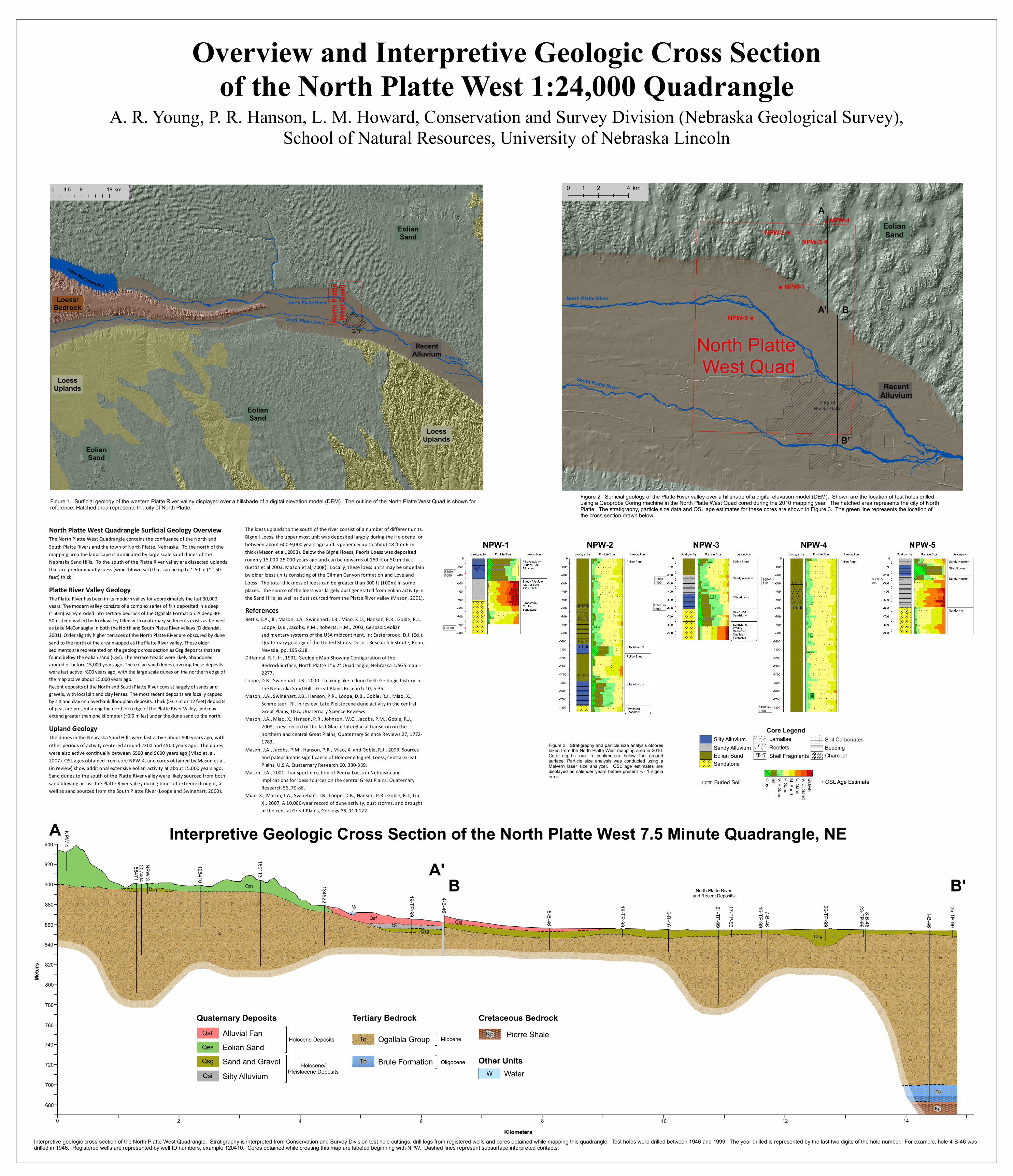
North Platte West Quadrangle Surficial Geology Overview The North Platte West Quadrangle contains the confluence of the North and South Platte Rivers and the town of North Platte, Nebraska. To the north of the mapping area the landscape is dominated by large scale sand dunes of the Nebraska Sand Hills. To the south of the Platte River valley are dissected uplands that are predominantly loess (wind -blown silt) that can be up to ~ 50 m (~ 150 feet) thick. Platte River Valley Geology The Platte River has been in its modern valley for approximately the last 30,000 years. The modern valley consists of a complex series of fills deposited in a deep (~50m) valley eroded into Tertiary bedrock of the Ogallala Formation. A deep 30-50m steep-walled bedrock valley filled with quaternary sediments exists as far west as Lake McConaughy in both the North and South Platte River valleys (Diddendal, 2001). Older slightly higher terraces of the North Platte River are obscured by dune sand to the north of the area mapped as the Platte River valley. These older sediments are represented on the geologic cross section as Qsg deposits that are found below the eolian sand (Qes). The terrace treads were likely abandoned around or before 15,000 years ago. The eolian sand dunes covering these deposits were last active ~800 years ago, with the large scale dunes on the northern edge of the map active about 15,000 years ago. Recent deposits of the North and South Platte River consist largely of sands and gravels, with local silt and clay lenses. The most recent deposits are locally capped by silt and clay rich overbank floodplain deposits. Thick (>3.7 m or 12 feet) deposits of peat are present along the northern edge of the Platte River Valley, and may extend greater than one kilometer (~0.6 miles) under the dune sand to the north.
The loess uplands to the south of the river consist of a number of different units. Bignell Loess, the upper most unit was deposited largely during the Holocene, or between about 600-9,000 years ago and is generally up to about 18 ft or 6 m thick (Mason et al.,2003). Below the Bignell loess, Peoria Loess was deposited roughly 15,000-25,000 years ago and can be upwards of 150 ft or 50 m thick (Bettis et al 2003; Mason et al, 2008). Locally, these loess units may be underlain by older loess units consisting of the Gilman Canyon formation and Loveland Loess. The total thickness of loess can be greater than 300 ft (100m) in some places. The source of the loess was largely dust generated from eolian activity in the Sand Hills, as well as dust sourced from the Platte River valley (Mason, 2001).
Upland Geology The dunes in the Nebraska Sand Hills were last active about 800 years ago, with other periods of activity centered around 2300 and 4500 years ago. The dunes were also active continually between 6500 and 9600 years ago (Miao et. al. 2007). OSL ages obtained from core NPW-4, and cores obtained by Mason et al. (in review) show additional extensive eolian activity at about 15,000 years ago. Sand dunes to the south of the Platte River valley were likely sourced from both sand blowing across the Platte River valley during times of extreme drought, as well as sand sourced from the South Platte River (Loope and Swinehart, 2000).
Overview and Interpretive Geologic Cross Sectionof the North Platte West 1:24,000 Quadrangle
8200+/-1000
>37,000
8900+/-1100
15500+/-1600
6300+/-970
860+/-120
14300+/-1300
A. R. Young, P. R. Hanson, L. M. Howard, Conservation and Survey Division (Nebraska Geological Survey),School of Natural Resources, University of Nebraska Lincoln
Figure 3. Stratigraphy and particle size analysis ofcorestaken from the North Platte West mapping area in 2010.Core depths are in centimeters below the groundsurface. Particle size analysis was conducted using aMalvern laser size analyzer. OSL age estimates aredisplayed as calender years before present +/- 1 sigmaerror.
920
940
900
880
860
840
820
800
780
760
740
720
700
680
NPW 4
58471NPW 3
126410
160113
134522 19-TP-99
4-B-46 5-B-46
18-TP-99
6-B-46
21-TP-99
17-TP-99
16-TP-997-B-46
26-TP-99
1-B-46
25-TP-99
8-B-4623-TP-99
207404
Tb
Kp
Quaternary DepositsAlluvial FanEolian SandSand and GravelSilty Alluvium
Holocene Deposits
Holocene/Pleistocene Deposits
Miocene
OligoceneBrule Formation
Ogallala Group
Tertiary Bedrock
Water
Pierre ShaleCretaceous Bedrock
Other Units
Qaf
Qsi
QesQsg
To
Tb
Kp
W
0 2 4 6 8 10 12 14
QafQsi
To
QsgQsgTo
Qaf
Meter
s
KilometersInterpretive geologic cross-section of the North Platte West Quadrangle. Stratigraphy is interpreted from Conservation and Survey Division test hole cuttings, drill logs from registered wells and cores obtained while mapping this quadrangle. Test holes were drilled between 1946 and 1999. The year drilled is represented by the last two digits of the hole number. For example, hole 4-B-46 wasdrilled in 1946. Registered wells are represented by well ID numbers, example 120410. Cores obtained while creating this map are labeled beginning with NPW. Dashed lines represent subsurface interpreted contacts.
W
North Platte Riverand Recent Deposits
A'B B'
Interpretive Geologic Cross Section of the North Platte West 7.5 Minute Quadrangle, NE
QesQsg
A
Figure 2. Surficial geology of the Platte River valley over a hillshade of a digital elevation model (DEM). Shown are the location of test holes drilledusing a Geoprobe Coring machine in the North Platte West Quad cored during the 2010 mapping year. The hatched area represents the city of NorthPlatte. The stratigraphy, particle size data and OSL age estimates for these cores are shown in Figure 3. The green line represents the location of the cross section drawn below.
!
!
!
!
!
North Platte River
South Platte River RecentAlluvium
City ofNorth Platte
A
A' B
B'
NPW-2
NPW-1
NPW-5
NPW-3
NPW-4
North Platte West Quad
0 2 41 km
EolianSand
North Platte River
South Platte River
Platte River
Lake McConaughy
Loess/Bedrock
RecentAlluvium
North
Platt
e We
st Qu
ad
LoessUplands
LoessUplands
0 9 184.5 km
EolianSand
EolianSand
EolianSand
Figure 1. Surficial geology of the western Platte River valley displayed over a hillshade of a digital elevation model (DEM). The outline of the North Platte West Quad is shown forreference. Hatched area represents the city of North Platte.
References Bettis, E.A., III, Mason, J.A., Swinehart, J.B., Miao, X.D., Hanson, P.R., Goble, R.J.,
Loope, D.B., Jacobs, P.M., Roberts, H.M., 2003, Cenozoic eolian sedimentary systems of the USA midcontinent, In: Easterbrook, D.J. (Ed.), Quaternary geology of the United States. Desert Research Institute, Reno, Nevada, pp. 195-218.
Diffendal, R.F. Jr., 1991, Geologic Map Showing Configuration of the BedrockSurface, North Platte 1° x 2° Quadrangle, Nebraska. USGS map I-2277.
Loope, D.B., Swinehart, J.B., 2000. Thinking like a dune field: Geologic history in the Nebraska Sand Hills. Great Plains Research 10, 5-35.
Mason, J.A., Swinehart, J.B., Hanson, P.R., Loope, D.B., Goble, R.J., Miao, X., Schmeisser, R., in review, Late Pleistocene dune activity in the central Great Plains, USA, Quaternary Science Reviews
Mason, J.A., Miao, X., Hanson, P.R., Johnson, W.C., Jacobs, P.M., Goble, R.J., 2008, Loess record of the last Glacial-Interglacial transition on the northern and central Great Plains, Quaternary Science Reviews 27, 1772-1783.
Mason, J.A., Jacobs, P.M., Hanson, P.R., Miao, X. and Goble, R.J., 2003, Sources and paleoclimatic significance of Holocene Bignell Loess, central Great Plains, U.S.A. Quaternary Research 60, 330-339.
Mason, J.A., 2001. Transport direction of Peoria Loess in Nebraska and implications for loess sources on the central Great Plains. Quaternary Research 56, 79-86.
Miao, X., Mason, J.A., Swinehart, J.B., Loope, D.B., Hanson, P.R., Goble, R.J., Liu, X., 2007, A 10,000-year record of dune activity, dust storms, and drought in the central Great Plains, Geology 35, 119-122.