survey information - slc.ca.gov · a total of 74 survey lines, covering ~74 km, were run during...
TRANSCRIPT
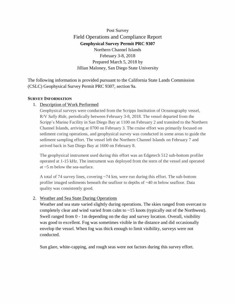
Post Survey
Field Operations and Compliance Report
Geophysical Survey Permit PRC 9307
Northern Channel Islands
February 3-8, 2018
Prepared March 5, 2018 by
Jillian Maloney, San Diego State University
The following information is provided pursuant to the California State Lands Commission
(CSLC) Geophysical Survey Permit PRC 9307, section 9a.
SURVEY INFORMATION
1. Description of Work Performed
Geophysical surveys were conducted from the Scripps Institution of Oceanography vessel,
R/V Sally Ride, periodically between February 3-8, 2018. The vessel departed from the
Scripp’s Marine Facility in San Diego Bay at 1100 on February 2 and transited to the Northern
Channel Islands, arriving at 0700 on February 3. The cruise effort was primarily focused on
sediment coring operations, and geophysical survey was conducted in some areas to guide the
sediment sampling effort. The vessel left the Northern Channel Islands on February 7 and
arrived back in San Diego Bay at 1600 on February 8.
The geophysical instrument used during this effort was an Edgetech 512 sub-bottom profiler
operated at 1-15 kHz. The instrument was deployed from the stern of the vessel and operated
at ~5 m below the sea-surface.
A total of 74 survey lines, covering ~74 km, were run during this effort. The sub-bottom
profiler imaged sediments beneath the seafloor to depths of ~40 m below seafloor. Data
quality was consistently good.
2. Weather and Sea State During Operations
Weather and sea state varied slightly during operations. The skies ranged from overcast to
completely clear and wind varied from calm to ~15 knots (typically out of the Northwest).
Swell ranged from 0 - 1m depending on the day and survey location. Overall, visibility
was good to excellent. Fog was sometimes visible in the distance and did occasionally
envelop the vessel. When fog was thick enough to limit visibility, surveys were not
conducted.
Sun glare, white-capping, and rough seas were not factors during this survey effort.

3. Survey Area Maps
Map 1: Overview of survey areas, north of Santa Rosa Island and in Santa Cruz Passage, east of Santa Rosa Island.
Map 2: Zoomed in view of survey area in Santa Cruz Passage, east of Santa Rosa Island.

4. Survey Track Line Coordinates Table 1:
Line # Start
Latitude Start
Longitude End
Latitude End
Longitude Length
(km)
CI2018B02L11 33.9893 -119.9649 33.9826 -119.9596 0.89
CI2018B02L12 33.9859 -119.9554 33.9906 -119.9656 1.99
CI2018B02L12a 33.9905 -119.9655 33.9868 -119.9625 0.49
CI2018B02L13 33.9859 -119.9545 33.9935 -119.9608 1.02
CI2018B02L14 33.9908 -119.9651 33.9823 -119.9585 1.13
CI2018B02L15 33.9856 -119.9549 33.9934 -119.9613 1.05
CI2018B02L16 33.9907 -119.9644 33.9830 -119.9585 1.02
CI2018B02L17 33.9927 -119.9604 33.9935 -119.9611 0.12
CI2018B02L17a 33.9854 -119.9542 33.9934 -119.9611 1.09
CI2018B02L18 33.9932 -119.9648 33.9831 -119.9583 1.30
CI2018B02L19 33.9913 -119.9641 33.9832 -119.9580 1.06
CI2018B02L20 33.9875 -119.9556 33.9936 -119.9605 0.82
CI2018B02L21 33.9918 -119.9642 33.9831 -119.9576 1.16
CI2018B02L22 33.9860 -119.9540 33.9938 -119.9604 1.06
CI2018B02L23 33.9913 -119.9634 33.9836 -119.9573 1.03
CI2018B02L24 33.9860 -119.9534 33.9939 -119.9600 1.07
CI2018B02L25 33.9919 -119.9635 33.9836 -119.9571 1.09
CI2018B02L26 33.9861 -119.9532 33.9941 -119.9600 1.10
CI2018B02L27 33.9926 -119.9631 33.9840 -119.9523 1.66
CI2018B02L28-1 33.9858 -119.9529 33.9940 -119.9595 1.10
CI2018B02L29 33.9922 -119.9628 33.9836 -119.9561 1.14
Map 3: Zoomed in view of survey area north of Santa Rosa Island.
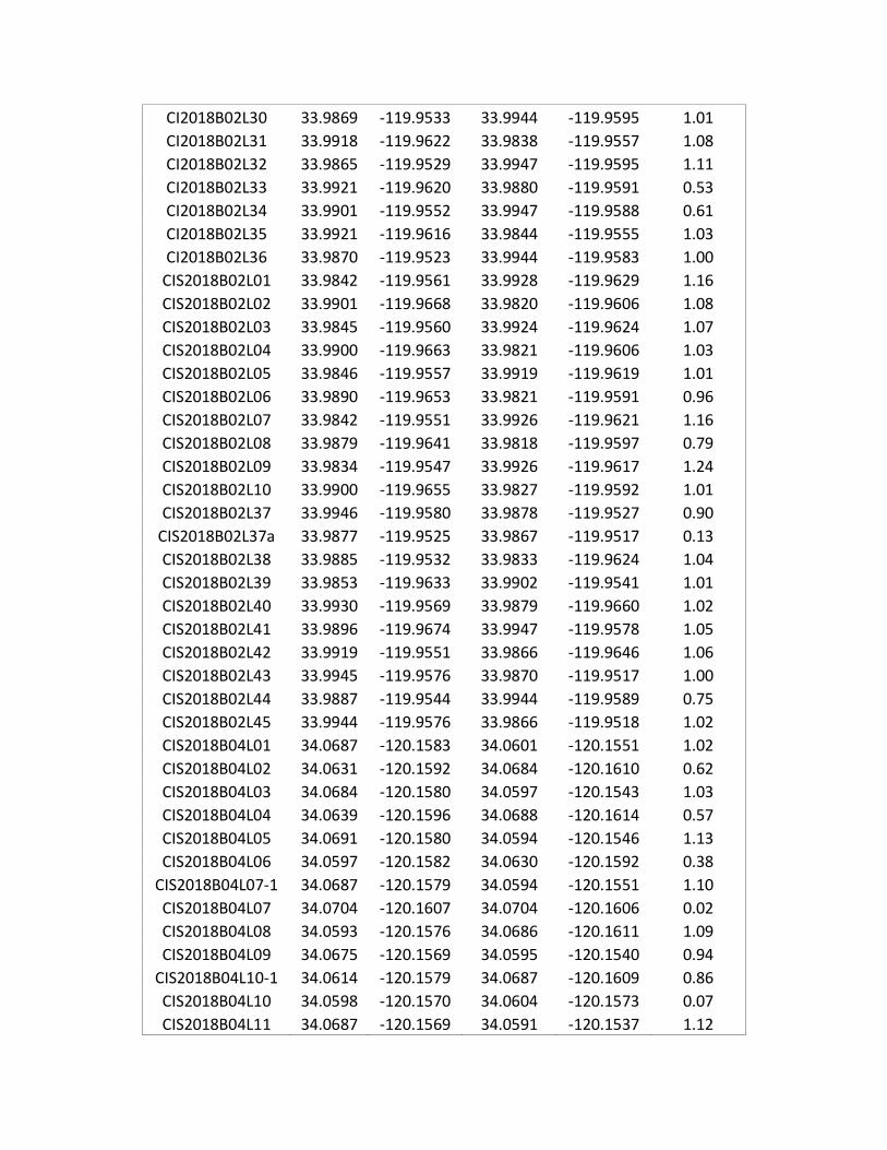
CI2018B02L30 33.9869 -119.9533 33.9944 -119.9595 1.01
CI2018B02L31 33.9918 -119.9622 33.9838 -119.9557 1.08
CI2018B02L32 33.9865 -119.9529 33.9947 -119.9595 1.11
CI2018B02L33 33.9921 -119.9620 33.9880 -119.9591 0.53
CI2018B02L34 33.9901 -119.9552 33.9947 -119.9588 0.61
CI2018B02L35 33.9921 -119.9616 33.9844 -119.9555 1.03
CI2018B02L36 33.9870 -119.9523 33.9944 -119.9583 1.00
CIS2018B02L01 33.9842 -119.9561 33.9928 -119.9629 1.16
CIS2018B02L02 33.9901 -119.9668 33.9820 -119.9606 1.08
CIS2018B02L03 33.9845 -119.9560 33.9924 -119.9624 1.07
CIS2018B02L04 33.9900 -119.9663 33.9821 -119.9606 1.03
CIS2018B02L05 33.9846 -119.9557 33.9919 -119.9619 1.01
CIS2018B02L06 33.9890 -119.9653 33.9821 -119.9591 0.96
CIS2018B02L07 33.9842 -119.9551 33.9926 -119.9621 1.16
CIS2018B02L08 33.9879 -119.9641 33.9818 -119.9597 0.79
CIS2018B02L09 33.9834 -119.9547 33.9926 -119.9617 1.24
CIS2018B02L10 33.9900 -119.9655 33.9827 -119.9592 1.01
CIS2018B02L37 33.9946 -119.9580 33.9878 -119.9527 0.90
CIS2018B02L37a 33.9877 -119.9525 33.9867 -119.9517 0.13
CIS2018B02L38 33.9885 -119.9532 33.9833 -119.9624 1.04
CIS2018B02L39 33.9853 -119.9633 33.9902 -119.9541 1.01
CIS2018B02L40 33.9930 -119.9569 33.9879 -119.9660 1.02
CIS2018B02L41 33.9896 -119.9674 33.9947 -119.9578 1.05
CIS2018B02L42 33.9919 -119.9551 33.9866 -119.9646 1.06
CIS2018B02L43 33.9945 -119.9576 33.9870 -119.9517 1.00
CIS2018B02L44 33.9887 -119.9544 33.9944 -119.9589 0.75
CIS2018B02L45 33.9944 -119.9576 33.9866 -119.9518 1.02
CIS2018B04L01 34.0687 -120.1583 34.0601 -120.1551 1.02
CIS2018B04L02 34.0631 -120.1592 34.0684 -120.1610 0.62
CIS2018B04L03 34.0684 -120.1580 34.0597 -120.1543 1.03
CIS2018B04L04 34.0639 -120.1596 34.0688 -120.1614 0.57
CIS2018B04L05 34.0691 -120.1580 34.0594 -120.1546 1.13
CIS2018B04L06 34.0597 -120.1582 34.0630 -120.1592 0.38
CIS2018B04L07-1 34.0687 -120.1579 34.0594 -120.1551 1.10
CIS2018B04L07 34.0704 -120.1607 34.0704 -120.1606 0.02
CIS2018B04L08 34.0593 -120.1576 34.0686 -120.1611 1.09
CIS2018B04L09 34.0675 -120.1569 34.0595 -120.1540 0.94
CIS2018B04L10-1 34.0614 -120.1579 34.0687 -120.1609 0.86
CIS2018B04L10 34.0598 -120.1570 34.0604 -120.1573 0.07
CIS2018B04L11 34.0687 -120.1569 34.0591 -120.1537 1.12

CIS2018B04L12 34.0602 -120.1560 34.0691 -120.1591 1.04
CIS2018B04L13 34.0690 -120.1567 34.0596 -120.1536 1.09
CIS2018B04L14 34.0605 -120.1575 34.0684 -120.1604 0.92
CIS2018B04L15 34.0687 -120.1586 34.0593 -120.1552 1.11
CIS2018B04L16 34.0654 -120.1590 34.0687 -120.1602 0.39
CIS2018B04L17 34.0690 -120.1566 34.0600 -120.1536 1.05
CIS2018B04L18 34.0596 -120.1569 34.0688 -120.1600 1.08
CIS2018B04L19 34.0693 -120.1565 34.0598 -120.1531 1.12
CIS2018B04L20 34.0603 -120.1567 34.0685 -120.1596 0.96
CIS2018B04L21 34.0692 -120.1563 34.0594 -120.1528 1.15
CIS2018B04L22 34.0591 -120.1569 34.0687 -120.1603 1.12
CIS2018B04L23 34.0682 -120.1580 34.0653 -120.1702 1.19
CIS2018B04L24 34.0611 -120.1681 34.0639 -120.1555 1.22
5. Dates and Times that Data Were Collected
Geophysical survey data were collected during the following dates and times:
February 4, 2018: 1400-1740 hrs
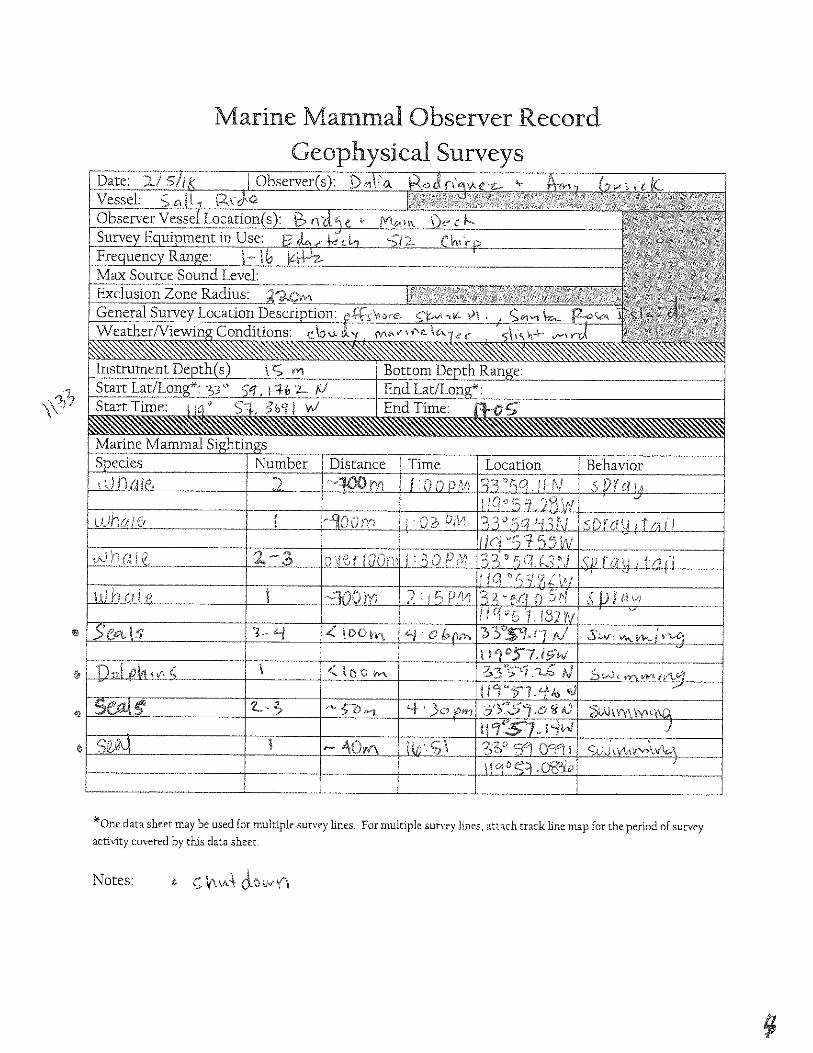
February 5, 2018: 1133-1705 hrs
February 6, 2018: 0900-1323 and 1530-1715 hrs
6. Environmental Hazards Encountered
In some areas fishing buoys (crab pots) were encountered and course deviations were
made to avoid entangling survey gear or damaging fishing gear.
7. Accident, Injury, Damage or Loss of Property
There were no accidents, injuries, or loss of property during this cruise.
8. Other Information Requested by CSLC
Please contact Jillian Maloney (San Diego State University) at (619) 594-6394 or David
Ball (Bureau of Ocean Energy Management) at (805) 384-6340 if any additional
information is needed.
BIOLOGICAL INFORMATION
1. Description of Marine Mammal, Reptile, and Bird Encounters
Table 2 provides a list of marine mammals observed during transit and/or during survey
operations. Observed marine mammals included the California sea lion (Zalophus
californianus), bottle-nose dolphin (Tursiops truncates), and gray whale (Eschrichtius
robustus). Whales were commonly observed transiting through the area between Santa

Rosa and Santa Cruz Islands. Whales were all either positively identified as gray whales,
or were unidentifiable due to distance. The whale behaviors observed included sprays and
flukes. Whales were observed as individuals or in groups of 2-3. Sea lions and dolphins
were often observed in small groups (2-8 individuals) and seemed to be more common in
the study area north of Santa Rosa Island. The observed sea lion behaviors observed were
swimming/transiting, rolling, and periscoping. Dolphins were observed
swimming/porpoising. Mammals were observed within the exclusion zone radius during
surveys, which required shut down of the geophysical equipment (see details in the shut
down section of this report).
Sea turtles are rarely seen in the Santa Barbara Channel and the northern Channel Islands.
No sea turtles were observed, either in transit or during survey operations. Seabirds were
observed frequently during transit and during survey operations.
Table 2: Marine Mammals Observed During Transit and/or During Survey Data Collection
Species Transit or Survey Frequency of Observation
California Sea Lion
(Zalophus californianus)
Transit and Survey Multiple sightings/multiple days
Bottle-Nosed Dolphin
(Tursiops truncates)
Transit and Survey Multiple sightings/multiple days
Gray Whale
(Eschrichtius robustus)
Transit and Survey Multiple sightings/multiple days
2. Description of Shut Downs or Slow Downs
Over the survey period, the survey equipment was shut down 20 times. During each shut-
down, the equipment remained off until the MWMs confirmed that the observed
mammals had left the exclusion zone. The sub-bottom profiler was then started at 10
percent power and ramped up to continue the survey. On the morning of February 5,
2018, fog was encountered in the survey area prior to deployment of the instruments. The
MWMs and crew decided to delay the survey until visibility improved. After ~ 2 hrs, the
visibility had improved and survey began.
The captain slowed the vessel on a few occasions, during transit back and forth from the
survey areas, to ascertain the location and direction of distant whales and readjusted
course as needed to avoid close approaches of whales during transit.
3. Observations of Pinnipeds at Haul-Out Sites
No pinnipeds were seen on beaches near survey areas, possibly because none of the
sampling areas were close enough to shore for easy identification.

4. Collision Events
There were no collision events during this survey effort.
5. Implementation and Compliance Verification
See completed copy of the Mitigation Monitoring Plan attached.
6. Marine Wildlife Monitor Evaluation of Mitigation Measures Performed
The R/V Sally Ride was an excellent platform for marine wildlife monitoring. The upper
deck and bridge allowed for 360 degree views of the operation for the primary observer.
The second observer was stationed closer to the stern of the vessel where the instrument
was towed and had an unobstructed view of ~240 degrees towards the stern. The captain
and survey crew were exceptionally responsive during the entire survey effort and
specifically during the shut-down events. They also remained vigilant and greatly
supplemented the observation effort when surveys were underway.

EXHIBIT H
Mitigation Monitoring_Program
llllltlgation Effectiveness Monitoring or Responsible Implementation Location anti Scope of Mitigation Timing Date(s) and Measure {MM) Criteria Reporting Action Party
Initials Air Qualiw and Greenhouse Gas {GHG) Emissions ,.,,ND Section 3.3.31 MM AIR-1: Engine All Counties: Maintain all construction equipment in Daily Determine engine OGPP permit Prior to, Tuning, Engine proper tune according to manufacturers' specifications; emissions of certification of vessel holder and during, and Certification, and fuel all off-road and portable diesel-powered equipment criteria engines. contract after - - -Fuels. The with California Air Resources Board (CARB)-certified pollutants vessel survey ¥
following measures motor vehicle diesel fuel limiting sulfur content lo 15 parts during survey Review engine operator; activities. 771§/115 will be required to per million or less (GARB Diesel). activities are emissions data to California
be implemented by minimized. assess compliance, State Lands Submit all Permittees determine if changes Commission Final under the Offshore in tuning or fuel are (CSLC) Monitoring Geophysical Permit reauired. review of Report Program (OGPP), Los Angeles and Orange Counties: Use vessel engines Verify that Tier 2 or Final after as applicable meeting CARB's Tier 2-certified engines or cleaner; the cleaner engines are Monitoring completion depending on the survey shall be operated such Iha! daily NO, emissions being used. Report. of survey county offshore do not exceed 100 pounds based on engine certification
Calculate daily NO, activities.
which a survey is emission factors. This can be accomplished with Tier 2 being conducted. engines if daily fuel use is 585 gallons or less, and with emissions to verify Pursuant lo section Tier 3 engines if daily fuel use is 935 gallons or less. compliance with 93118.5 of CARB's limitations. Airborne Toxic San Luis Obispo County: Use vessel engines meeting Verify Iha! Tier 2 or Control Measures, CARB's Tier 2-certified engines or cleaner, accomplished c!eaner engines are the Tier 2 engine with Tier 2 engines if daily fuel use is 585 gallons or less; being used. requirement all diesel equipment shall not idle for more than 5
Inform vessel applies only lo minutes; engine use needed to maintain position in the operator(s) of idling diesel-fueled water is not considered idling; diesel idling within 300 limitation. vessels. meters (1,000 feet) of sensitive receptors is not permitted;
use alternatively fueled construction equipment on site Investigate where feasible, such as compressed natural gas, liquefied availability of natural gas, propane or biodiesel. alternative fuels. Santa Barbara County: Use vessel engines meeting Verify that Tier 2 or CARB's Tier 2-certified engines or cleaner, accomplished cleaner engines are
~ with Tier 2 engines if daily fuel use is 790 gallons or less. being used.
Investigate /3fs'/1'? availability of alternative fuels.
Ventura County: Use alternatively fueled construction I nvestiga!e equipment on stte where feasible, such as compressed availability of natural oas, liauefied natural oas, orooane or biodiesel. alternative fuels.
Updated: 04/23/2014

EXHIBIT H Miti9_ation Monitoring Prog_ram
Mitigation Effectiveness Monitoring or Responsible !mplemenla!Jon
Location and Scope of Mitigation Timing Date{s)and Measure (MM) Crimria Reporting Aciion Party ln!liala
I\/IM BI0-1: Marine All State waters; prior to commencement of survey No adverse Document contact OGPP permit Prior to Mammal and Sea operations, the geophysical operator shall: (1) contact effects to with appropriate holder; survey. Turtle Presence - the National Oceanic and Atmosphelic Administration marine sources. Inquiry lo Curren! long Beach office staff and local whale-watching mammals or NOAA and Information. operations and shall acquire information on the current sea turtles due Submit Final local whale
composition and relative abundance of marine wildlife lo survey Monitoring Report watching offshore, and (2) convey sightings data to the vessel activities are after completion of operators. operator and crew, survey party chief, and onboard observed. survey activities. Marine Wildlife Monitors (MWMs) prior to departure. This information will aid the MWMs by providing data on the approximate number and types of organisms that may be in the area.
MM BI0-2: Marine Except as provided in section ?(h) of the General Permit, Competent Document contact OGPP permit Pliorto Wildlife Monitors a minimum of two (2) qualified MWMs who are and with and approval by holder. SU!Vey. (MWMs). experienced in marine wildlife observations shall be professional appropriate
~ -onboard the survey vessel throughout both transit and monitoring or agencies. data collection activities. The specific monitoring, marine ,/ observation, and data collection responsibilities shall be mammals and Submit Final g identified in the Marine Wildlife Contingency Plan required sea turtles; Monitoring Report as part of all Offshore Geophysical Permit Program compliance after completion of permits. Qualifications of proposed MWMs shall be with survey activities. submitted to the National Oceanic and Atmospheric established Administration (NOAA) and CSLC at least twenty-one monitoring (21) days in advance of the survey for their approval by policies. !he agencies. Survey operations shall no! commence until the CSLC annroves the MWMs.
MM BI0-3: Safety Onboard Marine Wildlife Monitors (MWMs) responsible No adverse Compliance with OGPP permit Prior to Zone Monitoring. for observations during vessel transit shall be responsible effects to permit requirements holder. survey. r for monitoring during the survey equipment operations. All marine (observers};
visual monitoring shall occur from the highest practical mammals or compliance with vantage point aboard the survey vessel; binoculars shall sea turtles due established safety g be used lo observe the surrounding area, as appropriate. to survey zones. The MWMs will survey an area (i.e., safely or exclusion activities are zone) based on the equipment used, centered on the observed; Submit Final sound source (i.e .. vessel, !owlish), throughout time Iha! compliance Monitoring Report the survey equipment is operating. Safety zone radial with after completion of distances, by equipment type, include: established survey activities.
safety zones.
Updated: 04/23/2014
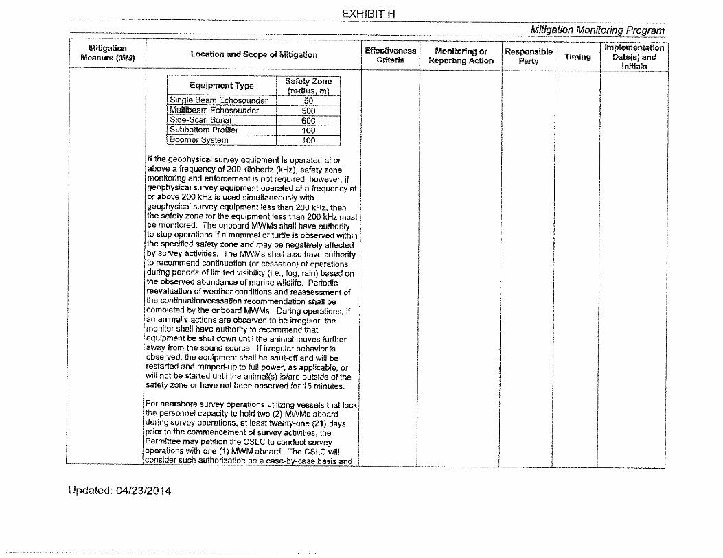
EXHIBIT H
Mitigation Monitoring Program
Mitigation Effectiveness Monitoring or Responsible Implementation Location and Scope of Mitigation Timing Da!e{s)and Measure (MM) Criteria Reporting Action Party
Initials
Equipment Type Safety Zone !radius, ml
Sinale Beam Echosounder 50 Multibeam Echosounder 500 Side-Scan Sonar 600 Subbottom Profiler 100 Boomer Svstem 100
If the geophysical survey equipment is operated at or above a frequency of 200 kilohertz (kHz), safety zone monitoring and enforcement is not required; however, if geophysical survey equipment operated al a frequency at or above 200 kHz is used simultaneously with geophysical survey equipment less than 200 kHz, then the safety zone for the equipment less than 200 kHz must be monitored. The onboard MWMs shall have authority lo stop operations if a mammal or turtle is observed within the specified safety zone and may be negatively affected by survey activities. The MWMs shall also have authority to recommend continuation (or cessation) of operations during periods of limited visibility (i.e., fog, rain) based on the observed abundance of marine wildlife. Periodic reevaluation of weather conditions and reassessment of the continuation/cessation recommendation shall be completed by the onboard MWMs. During operations, if an animal's actions are observed to be irregular, the monitor shall have authority to recommend that equipment be shut down until the animal moves further away from the sound source. If irregular behavior is observed, !he equipment shall be shut-off and will be restarted and ramped-up to full power, as applicable, or will not be started until the animal(s) is/are outside of the safety zone or have not been observed for 15 minutes.
For nearshore survey operations utilizing vessels that lack the personnel capacity lo hold two (2) MWMs aboard during survey operations, at least twenty-one (21) days prior to the commencement of survey activities, !he Permittee may petition the CSLC to conduct survey operations with one (1) MWM aboard. The CSLC will consider such authorization on a case-by-case basis and
Updated: 04/23/2014

EXHIBIT H Mitig_ation Monitoring Program
Mitigation Effac!iveness Monitoring or Responsible Implementation
Location and Scope of II/litigation Timing Date(s) and Measure (MM) Criteria Repor!lng Action Party Initials
factors the CSLC will consider will include the timing, type, and location of the survey, !he size of!he vessel, and !he availability of alternate vessels for conducting !he proposed survey. CSLC authorizations under this subsection will be limited to individual surveys and under any such authorization; the Permittee shall update the MWCP to reflect how survey operations will occur under the authorization.
MM BI0-4: Limits All Slate waters; nighttime survey operations are No adverse Presurvey request OGPP permit Approval on Nighttime prohibited under the OGPP, except as provided below. effects to for nighttime holder. required OGPP Surveys. The CSLC will consider the use of single beam marine operations, including before
echosounders and passive equipment types al night on a mammals or equipment survey is
~I'& case-by-case basis, taking into consideration the sea turtles due specifications and initiated. equipment specifications, location, timing, and duration of to survey proposed use survey activity. activities are schedule. Monitoring
observed. Report ( f\l<> (\ e._ ) Document equipment following
?t -1-' \"> '2/' \--use. comple-!ion of
Submit Final survey. Monitoring Report after completion of survev activities.
MM BI0-5: Soft All State waters; the survey operator shall use a "soft No adverse Compliance with OGPP permit Imme-Start. start" technique at the beginning of survey activities each effects lo permit requirements holder. diately
day (or following a shut down) to allow any marine marine (observers); prior to mammal that may be in the immediate area to leave mammals or compliance with safe survey. before the sound sources reach full energy. Surveys shall sea turtles due start procedures.
~/~ not commence at nighttime or when the safety zone lo survey cannot be effectively monitored. Operators shall initiate activities are Submit Final each piece of equipment at the lowest practical sound observed. Monitoring Report level, increasing output in such a manner as to increase in after completion of steps not exceeding approximately 6 decibels (dB) per 5- survey activities. minute peliod. During ramp-up, the Marine Wildlife Monitors (MWMs) shall monitor the safety zone. If marine mammals are sighted within or about to enter the safety zone, a power-down or shut down shall be implemented as though the equipment was operating at full power. Initiation of ramp-up procedures from shut down requires that the MWMs be able to visually observe the full safety zone.
Updated: 04/23/2014
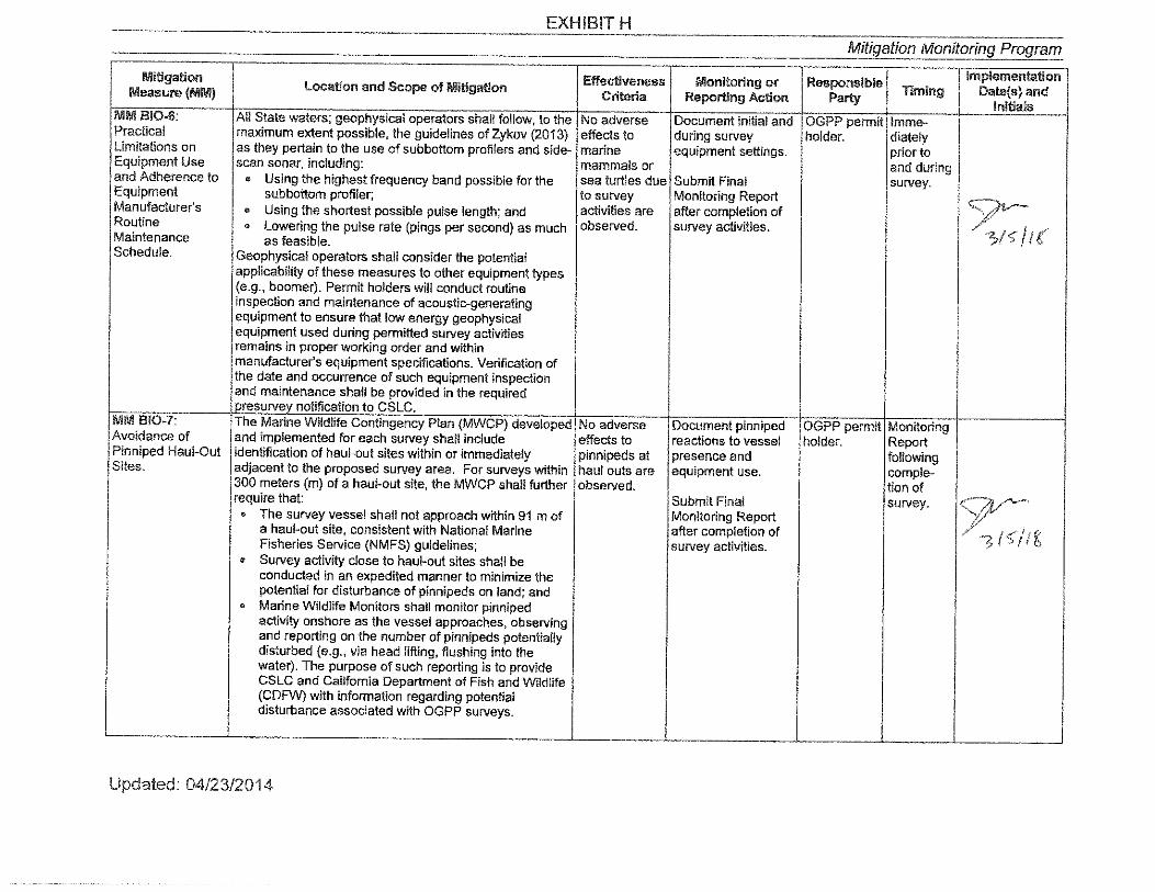
EXHIBIT H
Mitigation Monitoring_Program
Mi!igalion Effectiveness Monitoring or Responsible Implementation Measure (MM) location and Scope of Mi!lgallon
Criteria Reporting Acllon Party Timing Date(s) and lnl!ials
MMBI0-6: All State waters; geophysical operators shall follow, to the No adverse Document initial and OGPP permit Imme-Practical maximum extent possible, !he guidelines of Zykov (2013) effects to during survey holder. diately limitations on as !hey pertain to !he use of subbottom profilers and side- marine equipment settings. prior to Equipment Use scan sonar, including: mammals or and during and Adherence to • Using the highest frequency band possible for !he sea turtles due Submit Final survey . Equipment subbottom profiler; to survey Monitoring Report Manufacturer's • Using !he shortest possible pulse length; and activities are after completion of Routine • Lowering the pulse rate (pings per second) as much observed. survey activities.
/( Maintenance as feasible. Schedule. Geophysical operators shall consider the potential
applicability of these measures to other equipment types (e.g., boomer). Permit holders will conduct routine inspection and maintenance of acoustic-generating equipment to ensure that low energy geophysical equipment used during permitted survey activities remains in proper working order and within manufacturer's equipment specifications. Verification of !he date and occurrence of such equipment inspection and maintenance shall be provided in the required oresurvev notification to CSLC.
MM 810-7: The Marine Wildlife Contingency Plan (MWCP) developed No adverse Document pinniped OGPP permit Monitoring Avoidance of and implemented for each survey shall include effects to reactions to vessel holder. Report Pinniped Haul-Out identification of haul-out sites within or immediately pinnipeds al presence and following Sites. adjacent to the proposed survey area. For surveys within haul outs are equipment use. comple-
300 meters (m) of a haul-out site, !he MWCP shall further observed. !ion of require that: Submit Final survey. I;,~'& • The survey vessel shall not approach within 91 m of Monitoring Report
a haul-out site, consistent with National Marine after completion of Fisheries Service (NMFS) guidelines; survey activities.
• Survey activity close to haul-out sites shall be conducted in an expedited manner lo minimize the potential for disturbance of pinnipeds on land; and
• Marine Wildlife Monitors shall monitor pinniped activity onshore as the vessel approaches, observing and reporting on the number of pinnipeds potentially disturbed (e.g,, via head lifting, flushing into the water). The purpose of such reporting is lo provide CSLC and California Department of Fish and Wildlife (CDFW) with information regarding potential disturbance associated with OGPP surveys.
Updated: 04/23/2014

EXHIBIT H Mitigation MonitolinJJ Program
----------
Mitigation Effectiveness Monitoring or Responsible lmplementstion
location and Scope of Mitigation Timing Date(s) and Measure {MM) Criteria Reporting Action Party lnltlals
MM BI0-8: All Stale waters; if a collision with marine mammal or No adverse Submit Final OGPP permit Monitoring Reporting reptile occurs, the vessel operator shall document the effects lo Monitoring Report holder. Report Requirements - conditions under which the accident occurred. including marine after completion of following Collision. the following: mammals or survey activities. comple-
• Vessel location (latitude, longitude) when the collision sea turtles due tion of occurred; to survey survey.
• Dale and time of collision; activities are
• Speed and heading of the vessel a! the time of observed.
collision;
• Observation conditions (e.g .• wind speed and direction. swell height, visibility in miles or kilometers. and presence of rain or fog) at !he time of collision;
• Species of marine wildlife contacted (if known);
• Whether an observer was monitoring marine wildlife a! the lime of collision; and,
• Name of vessel, vessel owner/operator. and captain officer in charge of the vessel al time of collision .
After a collision. the vessel shall stop. if safe lo do so; however, the vessel is not obligated to stand by and may proceed after confirming that it will no! further damage the animal by doing so. The vessel will then immediately communicate by radio or telephone all detaiis to !he vessel's base of operations. and shall immediately report !he incident Consistent with Marine Mammal Protection Act requirements. the vessel's base of operations or, if an onboard telephone is available. the vessel captain him/herself. will !hen immediately call the National Oceanic and Atmospheric Administration (NOAA) Stranding Coordinator to report the collision and follow any subsequent instructions. From the report, the Stranding Coordinator will coordinate subsequent action. including enlisting !he aid of marine mammal rescue organizations, if appropriate. From the vessel's base of operations. a telephone call will be placed to the Stranding Coordinator, NOAA National Marine Fisheries Service (NMFS). Southwest Region, Long Beach. to obtain instructions. Although NOAA has primary responsibility for marine mammals in both State and Federal waters. the California Department of Fish and Wildlife (CDFW) will also be advised that an incident has occurred in Slate waters affec!ino a orotected soecies.
Updated: 04/23/2014
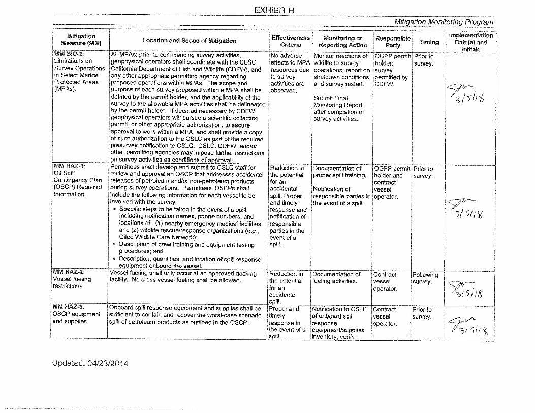
EXHIBIT H
Mitigation Monitoring_ Program
l\lll!igation Effectiveness Monitoring or Responsible !mplemenlalion Location and Scope of Mlliga!ion Torning Date{s) and Measure (MM) Criteria Reporting Ac!ion Party
lnllials MMB!0-9: All MPAs; prior to commencing survey activities, No adverse Monitor reactions of OGPP permit Prior to Limitations on geophysical operators shall coordinate with the ClSC, effects to MPA wildlife to survey holder; survey. Survey Operations California Department of Fish and Wildlife (CDFW), and resources due operations; report on survey in Select Marine any other appropriate permitting agency regarding to survey shu!down conditions permitted by Protected Areas proposed operations within MPAs. The scope and activities are and survey restart. CDFW. 1,---;;,/'--(MPAs). purpose of each survey proposed wl!hin a MPA shall be observed. ;1: I 1:, defined by the permit holder, and the applicabill!y of the Submit Final
survey to the allowable MPA activities shall be delineated Monitoring Report by the permit holder. If deemed necessary by CDFW, after completion of geophysical operators will pursue a scientific collecting survey activities. permit, or other appropriate aulhorization, to secure approval to work within a MPA, and shall provide a copy of such authorization to the CSLC as part of the required presurvey notification to CSLC. CSLC, CDFW, and/or other permitting agencies may impose further restrictions on survev activities as conditions of a,n,rovaL
MM HAZ-1: Permittees shall develop and submtt to CSLC staff for Reduction in Documentation of OGPP permit Prior to Oil Spill review and approval an OSCP !hat addresses accidental the potential proper spill !raining. holder and survey. Contingency Plan releases of petroleum and/or non-petroleum products for an contract (OSCP) Required during survey operations. Permittees' OSCPs shall accidental Notification of vessel Information. include the following information for each vessel to be spill. Proper responsible parties in operator. " involved with !he survey: and timely the even! of a spill.
• Specific steps to be taken in !he event of a spill, response and 5/1 r,t including notification names, phone numbers, and notification of
locations of: (1) nearby emergency medical facilities, responsible and (2) wildlife rescue/response organizations (e.g., parties in the Oiled Wildlife Care Network); event of a
• Description of crew training and equipment testing procedures; and
spill.
• Description, quantities, and location of spill response eouioment onboard the vessel.
!IIIM HAZ-2: Vessel fueling shall only occur at an approved docking Reduction in Documentation of Contract Following Vessel fueling facility. No cross vessel fueling shall be allowed. !he potential fueling activities. vessel survey. restrictions. for an operator.
I fS accidental soill.
11111\/1 HAZ-3: Onboard spill response equipment and supplies shall be Proper and Notification lo CSLC Contract Prior lo OSCP equipment sufficient lo contain and recover the worst-case scenario timely of onboard spill vessel survey. and supplies. spill of petroleum products as outlined in the OSCP. response ln response operator.
l I(, !he event of a equipmenUsupp!ies soilL inventorv, verifv
Updated: 04/23/2014
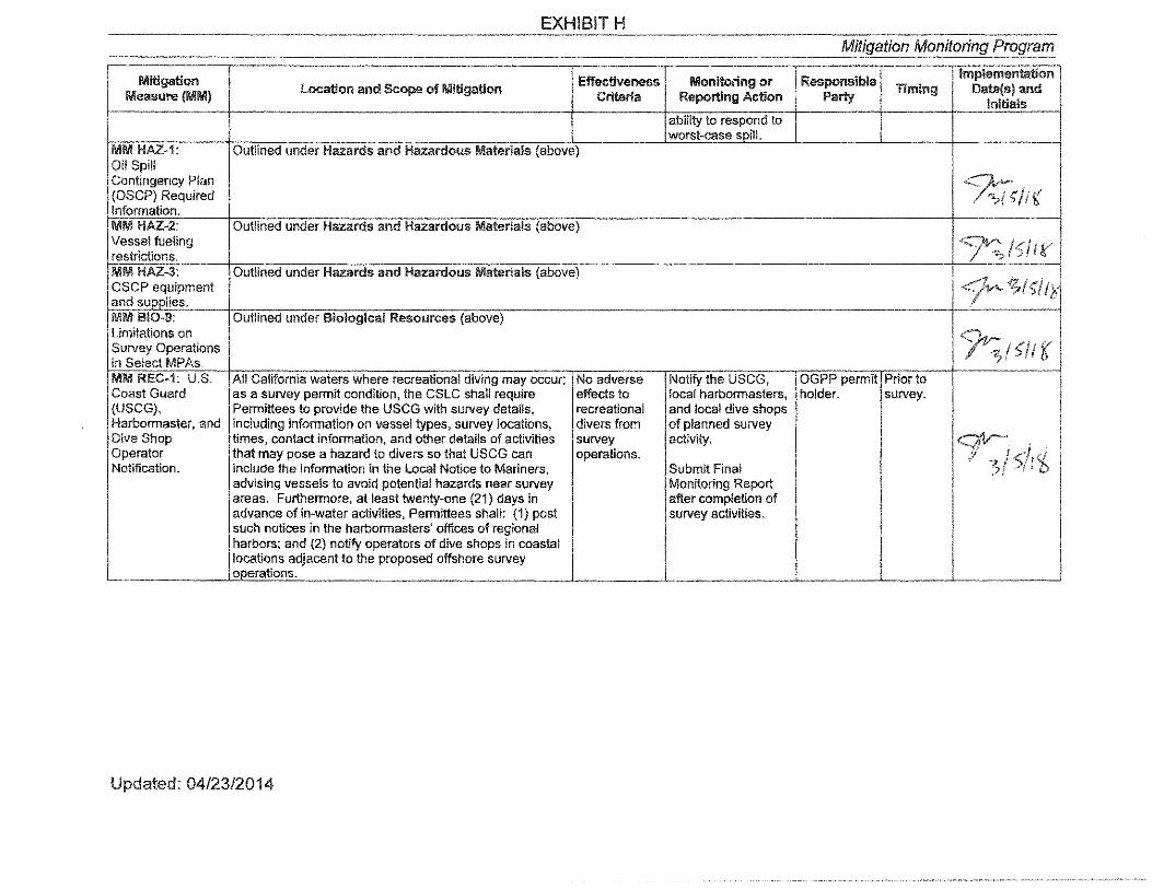
EXHIBIT H Mitigation Monitorin(J_ Program
11/ii!!gatlon Effectiveness Monitoring or Responsible Implementation
Measure (1!111\11) Location and Scope of Mltlga!!on Criteria Reporting Ac!!on Party Timing Date(s) and
Initials ability to respond to worst-case soilL
MM HAZ-1: Outlined under Hazards and Hazardous Materials (above) Oil Spill Contingency Plan (OSCP) Required Information.
!;
MM HAZ-2: Outlined under Hazards and Hazardous Materials (above) Vessel fueling 7".,?!5/ t' restrictions. l\lli\11 HAZ-3: Outlined under Hazards and Hazardous Materials (above) _.,,...-z.~ OSCP equipment f~ and sunnJies, 1· MM BI0-9: Outlined under Biological Resources (above) Limitations on Survey Operations 1( in Select MPAs. MM REC-1: U.S. All California waters where recreational diving may occur; No adverse Notify the USCG, OGPP permit Prior lo Coast Guard as a survey permit condition, the CSLC shall require effects to local harbormasters, holder. survey. (USCG), Permi!tees to provide !he USCG with survey details, recreational and local dive shops Harbormaster, and including information on vessel types, survey locations, divers from of planned survey Dive Shop limes, contact information, and other details of activities survey activity. ~-Operator that may pose a hazard to divers so that USCG can operations. I"#' 7 Notification. include the information in the Local Notice to Mariners, Submit Final .7
advising vessels to avoid potential hazards near survey Monitoring Report areas. Furthermore, at least twenty-one (21) days in after completion of advance of in-water activities, Permittees shall: (1) post survey activities. such notices in the harbormasters' offices of regional harbors; and (2) notify operators of dive shops in coastal locations adjacent to the proposed offshore survey onerations.
Updated: 04/23/2014

EXHIBIT H Mitigation Monitoring_ Program
Millgation Effectiveness Monitoring or Responsible lmplementallon
Loca!lon and Scope of Mlllgatlon Timing Date{s)and Measure (MM) Criteria Reporting Action Party initials
MM FISH-1: U.S. All California waters; as a survey permit condition, !he No adverse Notify the USCG and OGPP permit Prior to Coast Guard CSLC shall require Permittees lo provide the USCG with effects to local harbormasters holder. survey. (USCG) and survey details, including information on vessel types, commercial of planned survey Harbormaster survey locations, times, contact information, and other fishing gear in activity.
'?;:;11x Notification. details of activities that may pose a hazard to mariners place. and fishers so that USCG can include the information in Submit Final ,7( I'
the Local Notice to Mariners, advising vessels to avoid Monitoring Report potential hazards near survey areas. Furthermore, at after completion of least twenty-one (21) days in advance of in-water survey activities. activities, Permittees shall post such notices in the harbormasters' offices of r""ional harbors.
MM FISH-2: To minimize interaction with fishing gear !ha! may be No adverse Visually observe the OGPP permit Imme--Minimize present within a survey area: ( 1) !he geophysical vessel effects to survey area for holder. diately I n!eraction with (or designated vessel) shall traverse the proposed survey commercial commercial fishing prior to Fishing Gear. corridor prior to commencing survey operations to note fishing gear in gear. Notify the gear survey
7, and record the presence, type, and location of deployed place. owner and request (prior to fishing gear (i.e., buoys); (2) no survey lines within 30 m relocation of gear each
- ! ,; 1111 (100 feet) of observed fishing gear shall be conducted. outside survey area. survey ,r f. V The survey crew shall not remove or relocate any fishing day). gear; removal or relocation shall only be accomplished by Submit Final the owner of the gear upon notification by the survey Monitoring Report operator of the potential conflict. after completion of
survev activities. MM FISH-1: Outlined under Commercial and Recreational Fisheries USCG and (above) 9::;i l1 Harbormaster Notification.
Acronyms/Abbreviations: GARB = California Air Resources Board; CDFW = California Department of Fish and Wildlife; CSLC = California State Lands Commission; dB= decibels; kHz= kilohertz; MPA = Marine Protected Area; MWCP = Marine Wildlrfe Contingency Plan; MWM = Marine Wildlife Monitor, m= meter(s); NOAA = National Oceanic and Atmospheric Administration; NO, = Nitrogen Oxide; OGPP = Offshore Geophysical Permit Program; OSCP = Oil Spill Contingency Plan; USCG= U.S. Coast Guard
Updated: 04/23/2014

(! (l
Marine Mammal Observer Record Geophysical Surveys
*One data sheet may be used for multiple survey lines. For multiple survey lines, attach track line map for the per:iod of survey
activity covered by this data sheet.
Notes: d l 'i

L
Marine Mammal Observer Record Geophysical Surveys
Vessel: Observer Vessel Location s :
s Number
*One data sheet may be used for multiple survey lines. For multiple survey lines, attach track line map for the period of survey
activity covered by this data sheet.
Notes:

S ecies
Marine Mammal Observer Record Geophysical Surveys
Observers
Number Distance Time
L .. J
/
Location Behavior
*One data sheet may be used for multiple survey lines. For multiple sun·ey lines, attach track line map for the period of survey
activity covered by this data sheet.
Notes:
Marine Mammal Observer Record Geophysical Surveys
Date:
- 3 --, ·,, ,<
3' ,( i001,, 'i
',, ( \ ti C "'°'
:> --~ •1-"1
i
*One data sheet may be used for multiple survey lines. For multiple surYey lines, attach track line map for the period of survey
activity covered by this data sheet.
Notes: @ c;;

I)
t
@
@
Marine Mammal Observer Record Geophysical Surveys
Date:
Distance
{l
,onah0
~LPa )'
0 '')
\.
*One data sheet may be used for multiple survey lines. For multiple survey lines, attach track line map for the period of survey
activity covered by this data sheet.
Notes:

Marine Mammal Observer Record Geophysical Surveys
*One data sheet may be used for multiple sun·ey lines. For multiple survey lines, attach track line map for the period of survey
activity covered by this data sheet.
Notes:

Marine Mammal Observer Record Geophysical Surveys
Distance
(J
t
*One data sheet may be used for multiple survey lines. For multiple survey lines, attach track line map for the period of survey
activity covered by this data sheet.
Notes: C f

Marine Mammal Observer Record Geophysical Surveys
*One data sheet may be used for multiple survey lines. For multiple survey lines, attach track line map for the period of survey
activity covered by this data sheet.
Notes: ,,
S I ii