sustain model case study - scieca - south central …€¦ · · 2012-07-17support...
TRANSCRIPT

SUSTAIN Model Case StudySUSTAIN Model Case StudyMiddl Ri G dMiddle Rio Grande

What is SUSTAIN?What is SUSTAIN?What is SUSTAIN?What is SUSTAIN? SUSTAIN – System for Urban
Stormwater Treatment, and Analysis INtegration
An ArcGIS-based framework designed to support decision-makingD l d b T T h f EPA Offi Developed by Tetra Tech for EPA Office of Research and DevelopmentObj i Id if i Objective: Identify strategies to meet water quality goals at minimum costhttp://www.epa.gov/nrmrl/wswrd/wq/models/sustain/

SUSTAIN Basic QuestionsSUSTAIN Basic QuestionsSUSTAIN Basic QuestionsSUSTAIN Basic Questions How effective are BMPs or green g
infrastructure (GI) in reducing runoff and pollutant loadings?p g
What are the most cost-effective BMP solutions for meeting the water quantity so u o s o ee g e wa e qua yand quality objectives?◦ Where should the BMPs be located?Where should the BMPs be located? ◦ What type of BMPs should be used? ◦ How large should the BMPs be?How large should the BMPs be?

SUSTAIN CapabilitiesSUSTAIN CapabilitiesSUSTAIN CapabilitiesSUSTAIN Capabilities Watershed modelingg BMP process simulation BMP cost-benefit optimization BMP cost-benefit optimization Green infrastructure placement,
performance and cost for meeting flowperformance, and cost for meeting flow and/or water quality targets

SUSTAIN ModulesSUSTAIN ModulesSUSTAIN ModulesSUSTAIN Modules Framework Manager: Manages the data exchanges
(A GIS)(ArcGIS) ◦ BMP Siting Tool: Supports users in selecting suitable locations
for common structural BMPs ◦ Watershed/Land Module: Computes runoff and pollutant loads
from land (SWMM5/HSPF) ◦ BMP Module: Provides simulation of flow and pollutantBMP Module: Provides simulation of flow and pollutant
transport for structural BMPs◦ Optimization Module: Identifies cost-effective BMP placement
and selection strategiesand selection strategies ◦ Post-Processor: Centralized location for analyzing and
interpreting simulation outputs at multiple locations, and for scenarios and parameters of interestscenarios and parameters of interest

SUSTAIN Process DiagramSUSTAIN Process DiagramSUSTAIN Process DiagramSUSTAIN Process Diagram

SUSTAIN ApplicationsSUSTAIN ApplicationsSUSTAIN ApplicationsSUSTAIN Applications TMDL implementation plans Management practices to achieve
pollutant reductions Optimal green infrastructure strategies for
reducing volume and peak flows Benefits of distributed green infrastructure
on water quantity and quality in urban streams
Phased BMP installation plan using the t ff ticost effectiveness curve

SUSTAIN Case StudiesSUSTAIN Case StudiesSUSTAIN Case StudiesSUSTAIN Case Studies Kansas City, MO and Louisville, KYy◦ Investigated the use of green and/or gray
infrastructure practices to mitigate CSOs in temperate climate regions
Middle Rio Grande◦ Evaluate performance of small-scale structural
and non-structural management practices for various storm sizes in an arid region◦ Estimate the regional response of wide-spread
d i f h iadoption of these practices

MRG Case Study ObjectivesMRG Case Study ObjectivesMRG Case Study ObjectivesMRG Case Study Objectives Site-scale BMP optimization to derive
cost-benefit relationships for a selection of potential BMPs
Watershed-scale optimization in light of existing TMDL targetsI i i i l h d Integration into a regional watershed modeling framework
I f b i l t d i i◦ Inform basin-scale management decisions◦ Provide technical guidance for the pending
watershed-based MS4 permitwatershed based MS4 permit
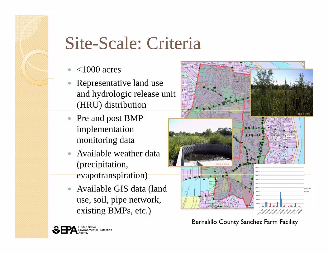
SiteSite--Scale: CriteriaScale: CriteriaSiteSite Scale: CriteriaScale: Criteria <1000 acres Representative land use
and hydrologic release unit (HRU) distribution
Pre and post BMP implementation monitoring datamonitoring data
Available weather data (precipitation, evapotranspiration)
180000
200000
evapotranspiration) Available GIS data (land
use, soil, pipe network, 20000
40000
60000
80000
100000
120000
140000
160000
ECOLI MPN
FC MPN
existing BMPs, etc.)Bernalillo County Sanchez Farm Facility
0

SiteSite--Scale: Key QuestionsScale: Key QuestionsSiteSite Scale: Key QuestionsScale: Key Questions What are the rainfall-runoff and rainfall-
pollutant load responses by HRUs? How well will potential GI practices perform
for various storm sizes? What is the impact of non-structural BMPs p
(e.g. street sweeping) on structural BMP treatment requirements and performance?
How would different formulation of TMDL objectives affect the BMP solutions?

SiteSite--Scale: Info NeededScale: Info NeededSiteSite Scale: Info NeededScale: Info Needed Pollutant of concern: E. coli◦ Death or regrowth rates
BMP informationBMP information◦ Suggested local BMP types◦ Local BMP design standardsLocal BMP design standards◦ Local BMP cost data◦ Suitable non-structural BMPs and◦ Suitable non-structural BMPs and
supporting performance metrics Representative simulation time period Representative simulation time period

BMP Performance in Bernalillo BMP Performance in Bernalillo CountyCounty Comparison of two sites provides a basis for
quantifying the performance of the implemented BMPs
Must have a similar mix of land uses◦ Sanchez Farms (managed with existing BMPs) Trash removal structures Sedimentation structures Flow through wetland Flow-through wetland
◦ Adobe Acres (control group without existing BMPs). )

WatershedWatershed--Scale: CriteriaScale: CriteriaWatershedWatershed Scale: CriteriaScale: Criteria Clearly defined management goal ◦ TMDL allocation◦ Permit requirements
Instream monitoring data Weather data GIS data (land use, digital elevation models,
soil, pipe network, stream, existing BMPs, th t ti t )weather stations, etc.)
Existing flow and water quality models

WatershedWatershed--Scale: Key QuestionsScale: Key QuestionsWatershedWatershed Scale: Key QuestionsScale: Key Questions What are the downstream regional responses
to upstream BMP implementation? ◦ Structural and non-structural
B d f d i d f it l◦ Based on performance derived from site-scale How can SUSTAIN be integrated into a
watershed management decision makingwatershed management decision making process?
What is the cumulative cost-benefit W s e cu u ve cos be erelationship of management at the watershed scale?

WatershedWatershed--Scale: Info NeededScale: Info NeededWatershedWatershed Scale: Info NeededScale: Info Needed Stormwater management objectives g j
(TMDL target, permit requirement)◦ E.g. Load duration curve analyses for g y
pollutant loading

Practice IdentificationPractice IdentificationPractice IdentificationPractice IdentificationFavorable Practice Unfavorable Practices
Harvesting parking lot runoff
Extensive use of rain
Swales Flow-through
structures Extensive use of rain barrels
Harvesting street
structures Rain gardens Green roofsg
runoff Detention facilities to
capture first flush flows
Green roofs
capture first flush flows Increased urban tree
coverLaBadie, K.T. 2010. Identifying Barriers to LID and GI in the Albuquerque Area.

BMPs Considered In MRG BMPs Considered In MRG SUSTAIN StudySUSTAIN Study Nonstructural BMPs ◦ Street sweeping ◦ Pet waste management
Structural BMPs ◦ Rainwater harvesting (harvest runoff from
rooftop, parking lot, and street) X i i d i◦ Xeriscaping or xerogardening◦ Detention basins designed to collect first flush
flowsflows

BMP Simulation ParametersBMP Simulation ParametersParameter Xeriscape Rainwater
collection Detention basin
Substrate
Ponding depth (ft) 0.042 -- 4
Substrate layer depth (ft) 2 -- 1
Substrate layer porosity 0 4 0 3Substrate layer porosity 0.4 -- 0.3
Vegetative parameter, A 1 -- 1
Background soil saturated 0.3 -- 0.3infiltration rate* (in/hr), fc
ET rate (in/day) 0.104 -- 0.104
Water QualityWater Quality
TSS 1st order decay rate (1/day), k
0.8 0.8 0.8
F l lif 1st d d 0 5 0 5 0 5Fecal coliform 1st order decay rate (1/day), k
0.5 0.5 0.5

Next StepsNext StepsNext StepsNext Steps A comprehensive SUSTAIN project is being developed to
present all combinations of BMP opportunities in the 100-present all combinations of BMP opportunities in the 100acre composite study area (Sanchez Farm) ◦ Nonstructural BMP scenarios will not be optimized Applied as background conditions for the structural BMP optimization
r nsruns ◦ Effectiveness of BMPs combinations, including nonstructural
and structural, will be evaluated and presented BMP performance evaluations are performed using threeBMP performance evaluations are performed using three
design storm time series. ◦ Methodology to tie the storm-based BMP performance with the
ultimate water quality control targets is being developed◦ The overall water quality targets will be used to further configure
the optimization

SUSTAIN ContactsSUSTAIN ContactsSUSTAIN ContactsSUSTAIN Contacts Ariamalar Selvakumar, EPA/ORD
l k i l @◦ [email protected]◦ Information on release and SUSTAIN related research
Michelle Latham, EPA/ORD,◦ [email protected]◦ Information and communication material on SUSTAIN
Nelly Smith EPA Region 6 Nelly Smith, EPA Region 6◦ [email protected]◦ EPA Region 6 MRG permit writer
Taimur Shaikh, EPA Region 6◦ [email protected]◦ EPA Region 6 modeling contactEPA Region 6 modeling contact

SUSTAIN Model Case StudySUSTAIN Model Case StudyMiddl Ri G dMiddle Rio Grande
Questions and Discussion