sustainable land imaging architecture tudy industry ... nasa... · 09.18.2013-ryker – 1 suomi npp...
TRANSCRIPT

09.18.2013-Ryker – 1
Suomi NPP VIIRS Visible Composite
SUSTAINABLE LAND IMAGING ARCHITECTURE STUDY
INDUSTRY & PARTNER DAY
Landsat Program Overview
U.S. Geological Survey September 18, 2013
Landsat 8 – Operational Land Imager (OLI) image taken May 28, 2013 of the
Copper River – Gulf of Alaska

09.18.2013-Ryker – 2
Landsat Mission
Objective:
- Acquire, archive, and distribute multispectral imagery affording global, synoptic, and repetitive coverage of the Earth's land surfaces at a scale where natural and human-induced changes can be detected, differentiated, characterized, and monitored over time.
Importance:
- The importance of Landsat derives not only from current sensor observations, but also from long-term data archiving, a global data acquisition strategy, an open data policy, rigorous calibration, and a commitment to data continuity.
Operational Continuity:
- Following four decades of successful imaging under changing program management structure and objectives, one-off satellite builds, and uncertainty about the future, we are now on a path toward sustained land imaging.

09.18.2013-Ryker – 3
National Space Policy/USGS Responsibilities
The Secretary of the Interior, through the Director of the USGS, shall:
– Conduct research on natural and human-induced changes to Earth’s land, land cover, and inland surface waters and manage a global land surface data national archive and its distribution;
– Determine the operational requirements for collection, processing, archiving, and distribution of land surface data to the U.S. Government and other users; and
– In support of these needs, the Director of the USGS and NASA Administrator shall work together in maintaining a program for operational remote sensing observations.

09.18.2013-Ryker – 4
USGS/NASA Landsat Partnership Since 1966

09.18.2013-Ryker – 5
NASA/USGS Landsat Roles
NASA:
• Develops sensors, satellites, and launches land imaging space systems
• Co-chairs USGS-funded Landsat Science Team
• Performs Earth-system measurements and research using land-image data
USGS:
• Documents user land imaging requirements
• Develops ground systems for land imaging space systems
• Operates land imaging satellites
• Collects, processes, archives and disseminates land-image data
• Establishes global land-coverage acquisition strategy
• Coordinates International Partner ground receiving station network
• Distributes data and information products at no charge
• Develops new data products and applications

09.18.2013-Ryker – 6
LAND USE/LAND COVER CHANGE
25%
FIRE SCIENCE/MGMT 17%
EDUCATION: UNIVERSITY/
COLLEGE 11%
ECOLOGICAL/ECOSYS SCIENCE/
MONITORING 9%
FOREST SCIENCE/MGMT
8%
AG FORECASTING 7%
WATER RESOURCES 5%
CRYOSPHERIC SCIENCE
4%
GEOLOGY 3%
AG MGMT/ PRODUCTION/
CONSERVATION 3%
CLIMATE SCIENCE/CHANGE
3%
BIODIVERSITY CONSERVATION
2% EMERGENCY/ DISASTER MGMT
1% OTHER USE
1%
ENVIRONMENTAL REGULATION
1%
Oct. 2012 – Apr. 2013
Landsat Data Users

09.18.2013-Ryker – 7
0
2
4
6
8
10
12
14
10
/1/0
7
10
/1/0
8
10
/1/0
9
10
/1/1
0
10
/1/1
1
10
/1/1
2
Free data policy October 1, 2008
Increasing Demand for Free Landsat Data M
illi
on
s o
f S
ce
ne
s D
ow
nlo
ad
ed
2008 2009 2010 2011 2012 2013

09.18.2013-Ryker – 8
Future Directions
• In a Landsat 9 timeframe (data acquisition beginning in 2018), there are a few options available that meet requirements, ranging from a clone of Landsat 8 to options requiring new technology development.
– These near-term solutions have varying levels of cost and risk
– Several partial solutions may provide sufficient data to augment the Landsat data stream or partially mitigate a data gap
• Technology development and demonstration now should significantly reduce costs, improve performance, and/or decrease risks in the timeframe of 2023 and beyond.
– A number of promising instrument and platform technologies (including hyperspectral imaging, smallsats, cheaper launch vehicles, hosted payload opportunities, etc.), but significant development required
– Revolutionary developments underway in ground systems; processing and dissemination approaches will benefit from new concepts and technologies
09.18.2013-Ryker – 9
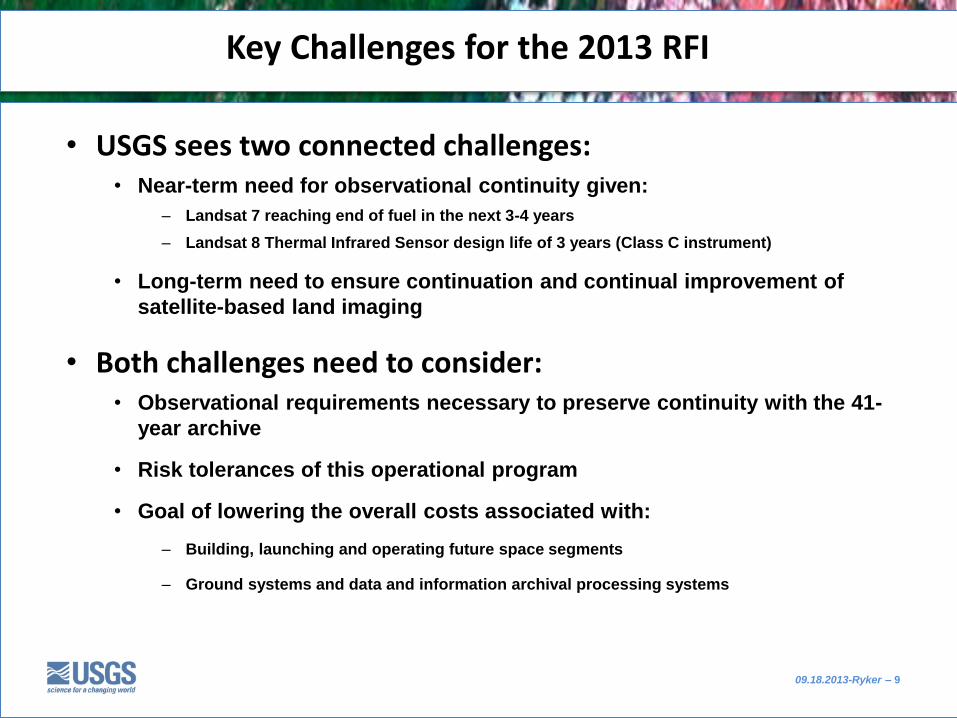
• USGS sees two connected challenges: • Near-term need for observational continuity given:
– Landsat 7 reaching end of fuel in the next 3-4 years
– Landsat 8 Thermal Infrared Sensor design life of 3 years (Class C instrument)
• Long-term need to ensure continuation and continual improvement of
satellite-based land imaging
• Both challenges need to consider: • Observational requirements necessary to preserve continuity with the 41-
year archive
• Risk tolerances of this operational program
• Goal of lowering the overall costs associated with:
– Building, launching and operating future space segments
– Ground systems and data and information archival processing systems
Key Challenges for the 2013 RFI

09.18.2013-Ryker – 10
• http://espd.gsfc.nasa.gov/landimagingstudy/documents/Industry_Partner_Day_Presentations.pdf
• Six speakers from OSTP, NASA HQ, USGS HQ