sutherland final report 2015
TRANSCRIPT

Southern Alliance Valuation Services Pty Ltd ABN : 80 099 913 210 Independent Property Valuers & Consultants email : [email protected] - web : www.savs.com.au Suite 5, Level 1, 2 East Street, Five Dock NSW 2046 PO Box 697 Five Dock NSW 2046 Tel (02) 9713-9077 Fax (02) 9713-9022
PROGRAM NARRATIVE
LAND TAX PROGRAM
DISTRICT 144 - SUTHERLAND
BASE DATE - 1 JULY 2015
Client : Department of Land and Property Management Authority Client Reference : Contract Agreement 923445 File Reference : Program Narrative – Sutherland 144

Land Valuation Services for Government Rating & Taxing Program Narrative – Final Report 2015 Valuation District 144 – Sutherland Local Government Area
___________________________________________________________________________________________________ Page 2 of 54 pages Southern Alliance Valuation Services Pty Ltd - File Ref: 2015 – 144 – Sutherland – Final Report
TABLE OF CONTENTS
EXECUTIVE SUMMARY .................................................................................................................... 3
1.0 GENERAL ...................................................................................................................................... 8
2.0 NUMBER OF VALUATIONS .................................................................................................... 11
3.0 TOWN PLANNING AND ZONING INSTRUMENTS ............................................................ 15
4.0 IDENTIFIED SIGNIFICANT CHANGES IN USE OR DEVELOPMENTS OF PROPERTY
AND OTHER FACTORS THAT MAY HAVE HAD AN AFFECT ON VALUES OR THAT MAY
CHANGE THE VALUE RELATIONSHIP COMPARED TO PRIOR VALUE LEVELS ........... 25
5.0 MARKET COMMENTARY ...................................................................................................... 28
6.0 METHODOLOGY, MANAGEMENT OF COMPONENTS, BENCHMARKS &
HANDCRAFTING ............................................................................................................................... 31
7.0 VALUE LEVELS AND MOVEMENTS .................................................................................... 33
8.0 TOTAL LAND VALUE VARIATIONS .................................................................................... 41
9.0 ADDED VALUE OF IMPROVEMENTS .................................................................................. 46
10.0 DETAILS OF OTHER ANCILLARY SERVICES ................................................................... 51
11.0 QUALITY ASSURANCE ............................................................................................................ 52
12.0 PURPOSE OF THIS REPORT ................................................................................................... 54

Land Valuation Services for Government Rating & Taxing Program Narrative – Final Report 2015 Valuation District 144 – Sutherland Local Government Area
___________________________________________________________________________________________________ Page 3 of 54 pages Southern Alliance Valuation Services Pty Ltd - File Ref: 2015 – 144 – Sutherland – Final Report
EXECUTIVE SUMMARY All properties in NSW are valued each year for rating and land tax purposes. All valuations are issued to the Office of State Revenue for land tax. Valuations are also issued to councils either each year or every 2nd, 3rd or 4th year. This report details the land valuation program for the Sutherland Shire Local Government Area (LGA). The majority of land values are determined using mass valuation techniques. The Valuer-General's mass valuation system is applied as follows:
1) Properties that react to market forces in a similar way are grouped together in a component, and
2) The existing values of those properties in a component are updated by a market-based
factor that is then used as a multiplier of the prior Land Value. The result is then checked by the Contract Valuer and individually verified values applied as appropriate.
The use of mass valuation techniques does have limitations, particularly over a period of time. The continued application of factors may lead to a distortion in the relativity of values within a geographical area. Some types of properties are so few in number or likely to be so sensitive to localised changes that individually verifying values is the only appropriate method. Although a mass valuation system is used to determine the majority of land values, the Valuation of Land Act requires that each land value be a market value. Each land value must be capable of being tested and supported on its own against all the available market evidence.
Total number of valuation entries in Sutherland LGA (as at 09/11/15 – BD 01/07/15) = 60,886

Land Valuation Services for Government Rating & Taxing Program Narrative – Final Report 2015 Valuation District 144 – Sutherland Local Government Area
___________________________________________________________________________________________________ Page 4 of 54 pages Southern Alliance Valuation Services Pty Ltd - File Ref: 2015 – 144 – Sutherland – Final Report
EXECUTIVE SUMMARY (cont.) Total land value in dollars in Sutherland LGA (as at 09/11/15 – BD 01/07/15) = $53,758,161,380
The last Local Government Base Date was : 1 July 2014. The last Land Tax Base Date was : 1 July 2014. Compared to the prior 2014 results, the current total number of assessments rose by 0.07% and the current total land value in dollars rose by 17.9%.

Land Valuation Services for Government Rating & Taxing Program Narrative – Final Report 2015 Valuation District 144 – Sutherland Local Government Area
___________________________________________________________________________________________________ Page 5 of 54 pages Southern Alliance Valuation Services Pty Ltd - File Ref: 2015 – 144 – Sutherland – Final Report
EXECUTIVE SUMMARY (cont.) Residential – Overall, the residential market within the Sutherland Shire Local Government Area has shown moderate to strong positive growth during the past 12 months leading up to Base Date 1 July 2015. The majority of single residential properties including waterfronts recorded positive variations from the prior 2014 Base Date results, generally ranging between 9% up to 32% depending on location. Medium and high density residential properties including mixed use (commercial / residential) sites recorded positive variations generally ranging between 17% up to 23%. The strength of the residential market within the Sutherland Shire LGA and generally within the Sydney Metropolitan Areas can be largely (but not solely) attributed to increase in investor demand, both locally and abroad, historical low interest rates, increase in Sydney’s population growth and a shortage of residential supply. Department of Housing figures for the March Quarter 2015 (below) show an upward trend in median price movements for residential properties throughout the Sydney Metropolitan Area year over year. More specifically, non-strata properties within the Sutherland Shire Government Area showed an increase in median price of 16.2% year over year whilst strata dwellings show an increase of 12.6% year over year.
Results from Department of Housing Sales Tables (March Quarter 2015) indicate the following:
Location Median Value (‘000’s) Change in Median (Annual)
District All
Dwellings Non
Strata Strata
All Dwellings
Non Strata
Strata
Sutherland (within Outer
Ring) 820 1,003 625 12.3 16.2 12.6
Sydney Metro –
Inner Ring 887 1,585 760 6.7 15.3 7.8
Sydney Metro –
Middle Ring 770 1,150 620 11.8 23.0 6.9
Sydney Metro –
Outer Ring 591 625 480 13.7 12.6 12.9
Please note a variety of factors can contribute to anomalies in the sale price and the end statistical data. The above information is viewed as a reference only for reporting purposes.

Land Valuation Services for Government Rating & Taxing Program Narrative – Final Report 2015 Valuation District 144 – Sutherland Local Government Area
___________________________________________________________________________________________________ Page 6 of 54 pages Southern Alliance Valuation Services Pty Ltd - File Ref: 2015 – 144 – Sutherland – Final Report
EXECUTIVE SUMMARY (cont.)
Commercial / Retail - Sales analysis of commercial / retail property within the Sutherland Shire Local Government Area for Base Date 2015 showed moderate growth generally ranging between 8% up to 23% depending on location and development potential. Commercial sites with mixed use potential generally experienced the strongest growth as a result of Sydney’s surging residential market. Business / Retail sites situated in close proximity to railway stations generally performed well throughout the LGA, whilst sites formerly classified as “Employment” experienced more modest increases in line with Industrial value movements.
Industrial - Sales analysis of industrial property within the Sutherland Shire Local Government Area showed some modest growth after a few years of stagnation, recording increases ranging generally between 5-10% from their prior Base Date levels. Table of typical land values (sample only):
Single Residential
Suburb Region Site Area 2015 LV
Cronulla South (5 Gardenia St)
Coastal 552m2 $1,450,000
Miranda (35 Violet St)
Inland 575m2 $780,000
Sutherland (19 Oakwood St)
Inland-West 696m2 $740,000
Menai (12 Carmarthen St)
Western 678m2 $695,000
Engadine (35 Poulter Ave)
South Western 556m2 $615,000
Caringbah South (422 Willarong Rd)
Waterfront 1,164m2 $1,600,000
Sylvania Waters (32 Castlereagh Cr)
Waterfront 664m2 $1,700,000
Woronora (137 Prices Cct)
Waterfront 841m2 $925,000

Land Valuation Services for Government Rating & Taxing Program Narrative – Final Report 2015 Valuation District 144 – Sutherland Local Government Area
___________________________________________________________________________________________________ Page 7 of 54 pages Southern Alliance Valuation Services Pty Ltd - File Ref: 2015 – 144 – Sutherland – Final Report
EXECUTIVE SUMMARY (cont.)
Residential Density
Suburb Development Site Area 2015 LV
Gymea (86-88 Manchester Rd)
4 VH / TH’s Medium Density
1,209m2
4 @ 302m2 each
$1,750,000 $1,447/m2
$437,500/site
Caringbah (3-5 Curtis St)
15 Home Units High Density
1,631m2
15 @ 109m2 each
$2,550,000 $1,563m2
$170,000/site Sutherland
(860 Old Princes Hwy) Mixed
(Bus / Res) 980m2 $2,200,000
$2,245/m2
Business / Retail
Suburb Development Site Area 2015 LV
Cronulla (45 Cronulla St)
Retail – 6.1m 186m2 $1,600,000 $262,295/lm ftge
Caringbah (329 Kingsway)
Retail – 6.1m 221m2 $760,000 $124,590/lm ftge
Kirrawee (152 Oak Rd)
Retail – 6.1m 259m2 $410,000 $67,213/lm ftge
Employment / Industrial
Suburb Precinct Site Area 2015 LV
Taren Point (45 Bay Rd)
Primary 4,018m2 $2,650,000 =$660/m2
Kirrawee (102-106 Bath Rd)
Secondary 4,598m2 $2,250,000 =$489/m2
Rodney Louie PMAPI Registration No.14422
Steven Halias AAPI CPV Sutherland Area Manager Southern Alliance Valuation Services Pty Ltd

Land Valuation Services for Government Rating & Taxing Program Narrative – Final Report 2015 Valuation District 144 – Sutherland Local Government Area
___________________________________________________________________________________________________ Page 8 of 54 pages Southern Alliance Valuation Services Pty Ltd - File Ref: 2015 – 144 – Sutherland – Final Report
1.0 GENERAL The Local Government Area of the Sutherland Shire is located at the southern coastal border of the Sydney metropolitan region. It is bounded by Bankstown City and the Georges River in the north, the South Pacific Ocean in the east, Wollongong City and Royal National Park in the south and Deadman's Creek, Woronora Dam and Campbelltown and Liverpool Cities in the west. The LGA has a total land area of approximately 370 square kilometres. The geography of the area ranges from beaches, wetlands, bays and rivers to tablelands dissected by deep river valleys and gorges. The Estimated Resident Population (official population) of the Sutherland Shire as at 30th June 2014 is 225,070. The population increased by 1,910 from the prior year, representing an increase of 0.86%.
Sutherland Shire Year (ending June 30) Number Change in number Change in percent
2003 212,719 2004 211,907 -812 -0.382005 211,460 -447 -0.212006 211,230 -230 -0.112007 213,161 +1,931 +0.912008 216,400 +3,239 +1.522009 219,065 +2,665 +1.232010 220,060 +995 +0.452011 220,250 +190 +0.092012 221,283 +1,033 +0.472013 223,160 +1,877 +0.852014 225,070 +1,910 +0.86
Source: Australian Bureau of Statistics, Regional Population Growth, Australia (3218.0). Compiled and presented in profile.id by .id, the population experts.

Land Valuation Services for Government Rating & Taxing Program Narrative – Final Report 2015 Valuation District 144 – Sutherland Local Government Area
___________________________________________________________________________________________________ Page 9 of 54 pages Southern Alliance Valuation Services Pty Ltd - File Ref: 2015 – 144 – Sutherland – Final Report
1.0 GENERAL (cont.) For local government purposes, the Sutherland Shire is divided into five wards, A-E. NB: The boundaries of which must be or are reviewed every four years.
Ward A: Bundeena, Burraneer, part of Caringbah, Cronulla, Dolans Bay, Kurnell, Lilli Pilli, Maianbar, North Cronulla, Port Hacking, part of Woolooware.
Ward B: Part of Caringbah, Grays Point, part of Gymea, part of Kirrawee, part of Miranda, part of
Sutherland and Yowie Bay. Ward C: Part of Caringbah, part of Jannali, Kareela, Kangaroo Point, part of Kirrawee, part of
Miranda, part of Sutherland, Sylvania, Sylvania Waters, Sylvania Heights, Taren Point, part of Woolooware.
Ward D: Audley, Engadine, Heathcote, part of Jannali, Loftus, North Engadine, part of Sutherland,
Waterfall, Woronora Heights, Yarrawarrah. Ward E: Alfords Point, Bangor, Barden Ridge, Bonnet Bay, Caravan Head, Como, Illawong, part of
Jannali, Lucas Heights, Menai, Oyster Bay, Sandy Point, part of Sutherland, Woronora

Land Valuation Services for Government Rating & Taxing Program Narrative – Final Report 2015 Valuation District 144 – Sutherland Local Government Area
___________________________________________________________________________________________________ Page 10 of 54 pages Southern Alliance Valuation Services Pty Ltd - File Ref: 2015 – 144 – Sutherland – Final Report
1.0 GENERAL (cont.) The Sutherland Shire is predominantly a residential area, however includes industrial, commercial and rural areas. The Shire also has extensive beaches, waterways, bushlands and parklands, including four national parks: Botany Bay, Georges River, Heathcote & Royal National Parks. Residential Property Types
Single residential dwellings, including waterfront properties
High density development
Dual occupancy developments Mixed residential / commercial developments
Medium density developments SEPP 5 Developments, including retirement villages
Rural residential Hostels etc….
Major, Sub-Regional & Community Shopping Centre / Complexes
Westfields, Miranda Fair (Regional) Southgate, Sylvania (Sub-Regional)
Caringbah Supacentre (Bulky Retail) Menai Marketplace (Community)
Bangor Shopping Centre (Community) Kareela Shopping Centre (Community)
Primary Retail Strip Development / Commercial Areas
Cronulla (Beachside Retail Strip) Caringbah
Miranda Sutherland
Gymea
Secondary Retail Strip Developments & Neighbourhood Centres
Sylvania Kirrawee
Menai Engadine
Illawong Village
Primary Industrial Areas
Taren Point (includes bulky goods) Caringbah (includes bulky goods)
Kirrawee (includes caryards) Kurnell (existing & developing areas)
The Sutherland LGA is also the location of major health, educational, industry & science organisations:
- Sutherland Hospital at Caringbah / Miranda including scattered private hospitals. - Southern Sydney Institute of TAFE at Gymea & Loftus. - Australian Nuclear, Science and Technology Organisation – ANSTO, Lucas Heights. - Waste Management Depots at Lucas Heights. - Caltex Oil Refinery at Kurnell (which will close in the second half of 2014 and converted into a major terminal for imported fuel). - Sewerage Treatment and the Sydney Desalination Plants at Kurnell.

Land Valuation Services for Government Rating & Taxing Program Narrative – Final Report 2015 Valuation District 144 – Sutherland Local Government Area
___________________________________________________________________________________________________ Page 11 of 54 pages Southern Alliance Valuation Services Pty Ltd - File Ref: 2015 – 144 – Sutherland – Final Report
2.0 NUMBER OF VALUATIONS
Zone Category Break-Up - (includes 09 November 2015 supplementary download)
Zone / Land Category Number
of Entries in 2014
Number of Entries
in 2015
Variation of
Entries #
Variation of
Entries %
Residential 56,865 56,967 +102 +0.18%
Business 866 1,415 +549 +63.39%
Employment* 748 0 -748 -100.00%
Industrial 72 660 +588 +816.67%
Mixed Zone* 285 0 -285 -100.00%
Open Space 1,110 1,331 +221 +19.91%
Non Urban* 211 0 -211 -100.00%
Special Uses 516 513 -3 -0.58%
Road Reservations & other* 169 0 -169 -100.00%
District Totals 60,842 60,886 +44 +0.07%
* The component format for the Sutherland Shire LGA has been amended during the 2015 program to
accommodate the new zones per Sutherland Shire LEP 2015. As a result, the following zone / land categories previously reported upon are no longer applicable;
- Employment (generally categorised with Industrial or Business properties for BD 2015) - Mixed Zone (generally categorised with Business properties for BD 2015) - Non Urban (generally categorised with Open Space properties for BD 2015) - Miscellaneous Road Reservation & Other (generally categorised with Special Uses properties for
BD 2015)

Land Valuation Services for Government Rating & Taxing Program Narrative – Final Report 2015 Valuation District 144 – Sutherland Local Government Area
___________________________________________________________________________________________________ Page 12 of 54 pages Southern Alliance Valuation Services Pty Ltd - File Ref: 2015 – 144 – Sutherland – Final Report
2.0 NUMBER OF VALUATIONS (cont.)

Land Valuation Services for Government Rating & Taxing Program Narrative – Final Report 2015 Valuation District 144 – Sutherland Local Government Area
___________________________________________________________________________________________________ Page 13 of 54 pages Southern Alliance Valuation Services Pty Ltd - File Ref: 2015 – 144 – Sutherland – Final Report
2.0 NUMBER OF VALUATIONS (cont.)
Residential Category Break-Up (includes 09 November 2015 supplementary download)
Zone / Land Category Number
of Entries in 2014
Number of Entries in
2015
Variation of
Entries #
Variation of
Entries %
Single Dwelling Sites (excl. W’fronts) 51,465 51,511 +46 +0.09%
Englobo Sites 25 21 -4 -16.00%
Waterfront Dwelling Sites 3,274 3,290 +16 +0.49%
Medium Density Sites 1,112 1,164 +52 +4.68%
High Density Sites 989 981 -8 -0.81%
Residential Totals 56,865 56,967 +102 +0.18%
NB: The above “Residential” Category Break-up” Valuations, exclude those existing / designated
sites zoned Business comprising of either retail and / or commercial premises with a residential home unit component. Those entries are located within the Business Zone / Category.
The above information & statistics were compiled from the data imported from the valuation download file emailed by Land & Property Information NSW on 23 January 2015 in addition to subsequent supplementary file downloads up to & including 09 November 2015.

Land Valuation Services for Government Rating & Taxing Program Narrative – Final Report 2015 Valuation District 144 – Sutherland Local Government Area
___________________________________________________________________________________________________ Page 14 of 54 pages Southern Alliance Valuation Services Pty Ltd - File Ref: 2015 – 144 – Sutherland – Final Report
2.0 NUMBER OF VALUATIONS (cont.)

Land Valuation Services for Government Rating & Taxing Program Narrative – Final Report 2015 Valuation District 144 – Sutherland Local Government Area
___________________________________________________________________________________________________ Page 15 of 54 pages Southern Alliance Valuation Services Pty Ltd - File Ref: 2015 – 144 – Sutherland – Final Report
3.0 TOWN PLANNING AND ZONING INSTRUMENTS
Planning instruments within the Sutherland Shire LGA as at 1 July 2015.
“SSLEP 2015” Sutherland Shire Local Environmental Plan 2015. Primary planning instrument for the Sutherland Shire Local Government Area. Date of Commencement on publication on Legislation Website 23rd June 2015. This plan applies to development applications lodged from 23rd June 2015.
If a development application was lodged before 23rd June 2015, but not finally determined before 23rd June 2015, it will be determined as if SSLEP 2015 had been exhibited and not been made - i.e. SSLEP 2015 is considered in the application as a draft plan under Section 79C of the Environmental Planning and Assessment Act. Clause 1.2 per SSLEP 2015 “Aims of Plan” are as follows: (1) This Plan aims to make local environmental planning provisions for land in Sutherland Shire in accordance with the relevant standard environmental planning instrument under section 33A of the Act. (2) The particular aims of this Plan are as follows: (a) to deliver the community’s vision for Sutherland Shire by achieving an appropriate balance between development and management of the environment that will be ecologically sustainable, socially equitable and economically viable, (b) to establish a broad planning framework for controlling development, minimising adverse impacts of development, protecting areas from inappropriate development and promoting a high standard of urban design, (c) to protect and enhance the amenity of residents, workers and visitors in all localities throughout Sutherland Shire, (d) to minimise risk to life, property and the environment from hazards, particularly bush fires, flooding and climate change, (e) to concentrate development in localities with adequate infrastructure that is accessible to transport and centres, (f) to protect and enhance the natural environment and scenic quality of the Sutherland Shire through the retention and rehabilitation of wildlife habitats, wildlife corridors, bushland, foreshores and waterways, (g) to conserve, protect and enhance the environmental and cultural heritage of Sutherland Shire, (h) to provide leisure and recreation opportunities to suit the needs of the changing population, (i) to meet the future housing needs of the population of Sutherland Shire.

Land Valuation Services for Government Rating & Taxing Program Narrative – Final Report 2015 Valuation District 144 – Sutherland Local Government Area
___________________________________________________________________________________________________ Page 16 of 54 pages Southern Alliance Valuation Services Pty Ltd - File Ref: 2015 – 144 – Sutherland – Final Report
3.0 TOWN PLANNING AND ZONING INSTRUMENTS (cont.) Clause 1.3 per SSLEP 2015 “Land to which plan applies” to the following:
(1) This Plan applies to the land identified on the Land Application Map. (1A) Despite subclause (1), this Plan does not apply to the land identified as “Deferred matter” on the Land Application Map.
Clause 1.8 per SSLEP 2015 “Repeal of planning instruments applying to land” include: (1) All local environmental plans and deemed environmental planning instruments applying only to the land to which this Plan applies are repealed. (2) All local environmental plans and deemed environmental planning instruments applying to the land to which this Plan applies and to other land cease to apply to the land to which this Plan applies. Note. While the following environmental planning instruments no longer apply to the land to which this Plan applies, they continue to apply to the land identified as “Deferred matter” under clause 1.3 (1A):
State Environmental Planning Policy (Kurnell Peninsula) 1989
Sutherland Shire Local Environmental Plan 2006
Southern Alliance Valuation Services will be/are continuing to maintain a library of amendments to SSLEP 2015. In total, there are 2 amendments, both of which have commenced on publication on the Legislation Website in 2015. Those amendments considered of importance and/or affecting a property’s value will be flagged for action and commented upon where required. A copy of current & former plans and instruments are available for viewing at Southern Alliance Valuation Services Offices or on the Sutherland Shire Council’s Customer Service Centre, Sutherland Shire Council Libraries, Sutherland Shire Council Website or on the Legislation Website. All changes to generic zoning and planning controls resulting from the relevant planning instruments have been acted upon and/or noted and/or will be acted upon immediately following supplementary workflow action preparation by Land & Property Information, NSW.

Land Valuation Services for Government Rating & Taxing Program Narrative – Final Report 2015 Valuation District 144 – Sutherland Local Government Area
___________________________________________________________________________________________________ Page 17 of 54 pages Southern Alliance Valuation Services Pty Ltd - File Ref: 2015 – 144 – Sutherland – Final Report
3.0 TOWN PLANNING AND ZONING INSTRUMENTS (cont.)
Some notable changes from the prior LEP include (but is not limited to): - Renaming of all zones - Reclassification of various precincts previously designated “Employment” under
SSLEP2006 to “Business”. - A separate Industrial Zoning, namely “Working Waterfront” designated for maritime
specific activities / complementary industries that require direct waterfront access. - A separate Special Purpose Zoning, namely ie. “SP3 Tourist” designated for natural or built
sites or locations which attract tourists and/or are intended to be used in the future for developing tourist related uses.
- Generally higher floor space ratios. - Generally increased building heights. - Generally reduced landscaped area in most localities. - Numerous spot rezoning throughout the LGA. Renaming of all zone classifications Residential Zones: E3 Environmental Management The E3 zone largely applies to land currently designated as Zone 1 – Environmental Housing (Environmentally Sensitive Land) under SSLEP2006, and small areas in Zone 2 – Environmental Housing (Scenic Quality) and Zone 17 – Environmental Protection (Low Impact Rural). These are areas primarily on or adjacent to the Shire’s waterways. E4 Environmental Living This zone is applied to the area currently zoned within Zone 2 – Environmental Housing (Scenic Quality) and Zone 3 – Environmental Housing (Bushland) under SSLEP2006, and some small areas of Zone 1 – Environmental Housing (Environmentally Sensitive Land). The E4 zone also applies to residential land in Kurnell Village, zoned 2 (a) Residential under State Environmental Planning Policy (Kurnell Peninsula) 1989. R2 Low Density Residential Zone The R2 zone generally applies to land that is within Zone 4 – Local Housing under the SSLEP2006, but also includes some small areas currently within Zone 2 – Environmental Housing (Scenic Quality). R3 Medium Density Residential Zone R3 generally applies to those areas designated as Zone 5 – Multiple Dwelling A under SSLEP2006. R4 High Density Residential Zone The R4 zone generally applies to areas designated as Zone 6 – Multiple Dwelling B under SSLEP2006, adjacent to town centres. Some residential flat precincts have been enlarged to deliver more housing in accordance with the Housing Strategy 2031, including various areas around Sutherland, Miranda and Caringbah.

Land Valuation Services for Government Rating & Taxing Program Narrative – Final Report 2015 Valuation District 144 – Sutherland Local Government Area
___________________________________________________________________________________________________ Page 18 of 54 pages Southern Alliance Valuation Services Pty Ltd - File Ref: 2015 – 144 – Sutherland – Final Report
3.0 TOWN PLANNING AND ZONING INSTRUMENTS (cont.) Business Zones: Under the SSLEP2015, ‘business zones’ refer to those zones which support a range of business, commercial and residential functions. In most instances, these zones have been applied to areas with equivalent uses under the SSLEP2006 ‘centre’ zones. However, the new LEP provides for an extended range of business zones to suit local circumstances. This has led to some land designated as Zone 11 - Employment under SSLEP2006 to receive a ‘business’ zone under the new LEP. B1 Neighbourhood Centre B1 generally applies to areas formally zoned as Zone 10– Neighbourhood Centre under SSLEP2006 and Zone 3(d) under SEPP (Kurnell Peninsula) 1989. Neighbourhood centres exist in many locations including Grays Point, Bundeena and Alfords Point.
B2 Local Centre The B2 zone generally applies to areas where Zone 9 – Local Centre applied under SSLEP2006 (e.g. Jannali, Kirrawee and Kareela Centres). B3 Commercial Core The B3 zone generally applies to areas formally zoned as Zone 8 – Urban Centre under SSLEP2006. B4 Mixed Use The B4 zone applies to part of Kirrawee Town Centre, including the Brick Pit and surrounds. B5 Business Development The B5 zone applies to part of Taren Point Road that constituted the bulky goods precinct under SSLEP2006. This precinct has been enlarged to the north, along the east side of Taren Point Road to Toorak Avenue. Both of these areas were previously zoned for Employment (Zone 11). B6 Enterprise Corridor The B6 Enterprise Corridor zone applies to certain parcels along the Princes Highway at Sylvania, Kirrawee, Engadine and Heathcote as well as the existing employment area in Menai. These areas were primarily within Zone 11 – Employment under SSLEP2006. However, some small areas were within Zone 10 – Neighbourhood Centre, Zone 22 – Arterial Road, Zone 15 – Private Recreation, Zone 3 – Environmental Housing (Bushland) and Zone 5 – Multiple Dwelling A. B7 Business Park The B7 zone applies to three key areas in the Taren Point and Caringbah employment area: the Toyota Site, the former Johnson and Johnson/Pfizer site and the area off Atkinson Road north. The areas around these properties are also included within the zone. These areas were identified through the Sutherland Shire Employment Strategy 2031.

Land Valuation Services for Government Rating & Taxing Program Narrative – Final Report 2015 Valuation District 144 – Sutherland Local Government Area
___________________________________________________________________________________________________ Page 19 of 54 pages Southern Alliance Valuation Services Pty Ltd - File Ref: 2015 – 144 – Sutherland – Final Report
3.0 TOWN PLANNING AND ZONING INSTRUMENTS (cont.) Industrial Zones: IN1 General Industrial IN1 applies to much of the land formally zoned as Zone 11 - Employment under the SSLEP2006, and allows generally equivalent industrial uses. IN2 Light Industrial The zone is applied to parts of the industrial areas of Taren Point, Kirrawee and Kurnell, as well as to other small industrial areas adjacent to residential zones. IN3 Heavy Industrial This zone will apply to the area occupied by the Caltex Oil Refinery in Kurnell, which was formally zoned Zone 4(c1) (Special Industrial (Oil Refining) Zone) under the State Environmental Planning Policy (Kurnell Peninsula) 1989 (SEPP Kurnell). IN4 Working Waterfront IN4 applies only to waterfront land on the northern side of Mangrove Lane, Taren Point. This area was formally designated as Zone 11 - Employment under SSLEP2006. Special Purpose Zones: SP1 Special Activities The SP1 Special Activities zone replaces the former ‘special uses’ zone in those locations where there are no adjacent ‘prescribed zones’ (as set out in the Infrastructure SEPP) for the existing use. It is intended for land uses or sites with special characteristics that cannot be accommodated in other zones; for example, large complexes like a major scientific research facility (e.g., ANSTO), a waste recycling facility or a health service facility (e.g., Sutherland Hospital). SP2 Infrastructure This zone is reserved for infrastructure land that is highly unlikely to be used for a different purpose in the future, such as water supply systems and sewage treatment facilities. It is also used for land with existing or proposed major state infrastructure (e.g., classified roads), and for strategic sites such as Commonwealth land used for Defence purposes. SP3 Tourist This zone is applied land in Cronulla that was previously zoned as Zone 6 – Multiple Dwelling B in SSLEP2006 is a new approach to the use of this land.

Land Valuation Services for Government Rating & Taxing Program Narrative – Final Report 2015 Valuation District 144 – Sutherland Local Government Area
___________________________________________________________________________________________________ Page 20 of 54 pages Southern Alliance Valuation Services Pty Ltd - File Ref: 2015 – 144 – Sutherland – Final Report
3.0 TOWN PLANNING AND ZONING INSTRUMENTS (cont.) Recreation Zones: E1 National Parks and Nature Reserves This is a direct zone transfer. Zone E1 applies to the land that was previously Zone 20 – National Parks, Nature Reserves and State Conservation Areas (SSLEP2006) and Zone 8(a) – National Parks and Nature Reserves (SEPP Kurnell). Some land zoned Zone 14 – Public Open Space under SSLEP2006, and land forming part of the Towra Point Nature Reserve (zoned Zone 9(a) under SEPP Kurnell) is also included within Zone E1. E2 Environmental Conservation The E2 zone generally applies to public land previously designated as Zone 14 – Open Space (Bushland) and parts of Zone 17 – Environmental Protection (Low Impact Rural) under SSLEP2006. It also applies to some lands deferred under SSLEP 2006. The zones of these areas under SSLEP2000 are: 1 (a) Rural, 1 (b) Rural (Future Urban), 5 (a) Special Uses, 6 (a) Public Recreation, 6 (c) Regional Recreation and 7 (b) Environmental Protection (Bushland). On the Kurnell Peninsula, the E2 zone is now applied to some privately owned land with recognised State or regional conservation and recreation values, previously zoned 6(b) Public Recreation (Proposed) and 7(b) Special Development under Kurnell SEPP 1989. RE1 Public Recreation The RE1 zone is primarily applied to general open space, recreational areas, public reserves and sporting grounds on land formally designated as Zone 13 – Public Open Space under SSLEP2006 and land formally designated as Zone No 6(a) Public Recreation (Existing) under SEPP (Kurnell Peninsula) 1989. It has also been applied to some lands formally in Zone 14 - Public Open Space (Bushland), and to areas on the Kurnell Peninsula, which are owned by Council and not gazetted as National Park, yet formally designated as Zone No 8(a) National Parks and Nature Reserves under the Kurnell SEPP. It has also been applied to land formally in Zone No 6(c) (Private Recreation Zone) owned by Council or the State Government. RE2 Private Recreation Zone RE2 is a direct transfer of the land that was formally within Zone 15 – Private Recreation (SSLEP2006) and Zone 6(c) – Private Recreation (SEPP Kurnell).

Land Valuation Services for Government Rating & Taxing Program Narrative – Final Report 2015 Valuation District 144 – Sutherland Local Government Area
___________________________________________________________________________________________________ Page 21 of 54 pages Southern Alliance Valuation Services Pty Ltd - File Ref: 2015 – 144 – Sutherland – Final Report
3.0 TOWN PLANNING AND ZONING INSTRUMENTS (cont.) The Draft Sutherland Shire Development Control Plan 2015 has been adopted to support the planning controls of the new LEP. All applications made after 23rd June 2015 will be assessed having regard to the provisions of the new LEP in conjunction with this planning instrument. The Draft SSDCP 2015 supersedes all previous DCP’s including the Sutherland Shire DCP 2006, the Greenhills Beach DCP and various Kurnell and LEP 2000 DCP’s. Topics covered in the Draft SSDCP 2015 include:
Dwelling houses Secondary dwellings (granny flats) Dual occupancies Multi dwelling housing (villas and townhouses) Residential flat buildings New residential precincts Uses ancillary to residential development including garages, carports, hardstand spaces,
fences, retaining walls, swimming pools Late night trading Business zones New commercial precincts Industrial zones Private recreation zones Waterway zones Streetscape, building form and siting Bed and breakfast accommodation Child care centres Health consulting rooms Telecommunications and radio communications infrastructure Signage Brothels Restricted premises Neighbourhood shops and shop to housing Waste management Environmental topics including natural resource management, stormwater and
groundwater management, environmental risk Maps related to environmental topics Transport topics including vehicular access, roads, traffic, parking and bicycles Social consideration topics
Any valuation recommendations made with a DVM (Date Valuation Made) on or after the 23rd June 2015, have had regard to the new LEP & Draft DCP, except for those exclusions and deferred matters, whereby the superseded was adopted. Below is a summary of general development requirements under the new planning instruments. It is strongly recommended that reference be made to the planning instruments including associated maps for confirmation.

Land Valuation Services for Government Rating & Taxing Program Narrative – Final Report 2015 Valuation District 144 – Sutherland Local Government Area
___________________________________________________________________________________________________ Page 22 of 54 pages Southern Alliance Valuation Services Pty Ltd - File Ref: 2015 – 144 – Sutherland – Final Report
3.0 TOWN PLANNING AND ZONING INSTRUMENTS (cont.)
Zone Maximum
FSR
Minimum Landscape
Areas
Minimum Site Areas
Minimum Dimensions
Zone E3 Environmental Management
0.5:1
40% (excl paved area)
Generally 850m2 (standard) 1,000m2 (internal)
Width – 18m Depth – 27m
Zone E4 Environmental Living
0.5:1 or 0.55:1 (depending on location)
40% (excl paved area)D
Generally 500m2 to 700m2 (standard) 750m2 to 850m2 (internal)
Width – 18m Depth – 27m
Zone R2 Low Density Residential
Generally 0.55:1
35% (excl paved area)
Generally 550m2 (standard) 700m2 (internal)
Width – 15m Depth – 27m
Zone R3 Medium Density Residential
Generally 0.7:1, however some areas have higher densities
30% (excl paved area)
Generally 550m2 (standard) 700m2 (internal)
Width – 15m Depth – 27m
Zone R4 High Density Residential
Generally 1.2:1, however some areas have higher densities
30% (excl paved area)
Zone B1 Neighbourhood Centre
Generally 1:1 No Requirement
No Requirement
Zone B2 Local Centre
Varies between Centres
No Requirement
No Requirement

Land Valuation Services for Government Rating & Taxing Program Narrative – Final Report 2015 Valuation District 144 – Sutherland Local Government Area
___________________________________________________________________________________________________ Page 23 of 54 pages Southern Alliance Valuation Services Pty Ltd - File Ref: 2015 – 144 – Sutherland – Final Report
3.0 TOWN PLANNING AND ZONING INSTRUMENTS (cont.)
Zone Maximum
FSR
Minimum Landscape
Areas
Minimum Site Areas
Minimum Dimensions
Zone B3 Commercial Core
Varies between Centres
No Requirement
No Requirement
Zone B4 Mixed Use
Varies across Kirrawee
No Requirement
No Requirement
Zone B5 Business Development
1.5:1 10% (excl paved area)
No Requirement
Zone B6 Enterprise Corridor
1:1 10% (excl paved area)
No Requirement
Zone B7 Business Park
Zone IN1 General Industrial
Varies depending on location
10% (excl paved area)
Zone IN2 Light Industrial
Varies depending on location
10% (excl paved area)
Zone IN3 Heavy Industrial
1:1 10% (excl paved area)
Zone IN4 Working Waterfront
1.5:1 10% (excl paved area)

Land Valuation Services for Government Rating & Taxing Program Narrative – Final Report 2015 Valuation District 144 – Sutherland Local Government Area
___________________________________________________________________________________________________ Page 24 of 54 pages Southern Alliance Valuation Services Pty Ltd - File Ref: 2015 – 144 – Sutherland – Final Report
3.0 TOWN PLANNING AND ZONING INSTRUMENTS (cont.) Dual occupancy:
Permitted in the following zones; R2 Low Density Residential, R3 Medium Density Residential, R4 High Density Residential, B1 Neighbourhood Centre & SP3 Tourist.
E3 Environmental Management - Very limited permissible in Area B of the Additional Permitted Uses Map where one dwelling in the foreshore area is in existence for at least three years prior to the commencement of the LEP. Must meet the requirements outlined in Schedule 1 - Additional Permitted Uses.
E4 Environmental Living - Permissible in Area A of the Additional Permitted Uses Map. Generally excludes areas with bushfire or evacuation risk. Strata subdivision of dual occupancy is permissible.
Medium Density Development (Multi dwelling housing): Permitted in the following zones; R2 Low Density Residential, R3 Medium Density Residential, R4 High Density Residential & SP3 Tourist.
As at the date of this report, a minimum site width of 20 metres is required for multi dwelling development in R2, R3 and R4 zones per Draft SSDCP 2015. This may be subject to change.
High Density Development (Residential Flat Buildings): Permitted in the following zones; R4 High Density Residential & SP3 Tourist.
Generally a minimum frontage width of 26 metres is considered appropriate. Please refer to the Draft SSDCP 2015 for more specific controls including those sites within the Pinnacle Street Precinct, Caringbah North Residential Flat Precinct, Caringbah Medical Precinct and SP3 Tourist Prince Street.
The town planning particulars detailed within this section of the report have been extracted from the relevant planning instruments and are general in nature. It is recommended that any reader refer to the instruments in whole including associated maps for confirmation.

Land Valuation Services for Government Rating & Taxing Program Narrative – Final Report 2015 Valuation District 144 – Sutherland Local Government Area
___________________________________________________________________________________________________ Page 25 of 54 pages Southern Alliance Valuation Services Pty Ltd - File Ref: 2015 – 144 – Sutherland – Final Report
4.0 IDENTIFIED SIGNIFICANT CHANGES IN USE OR DEVELOPMENTS OF PROPERTY AND OTHER FACTORS THAT MAY HAVE HAD AN AFFECT ON VALUES OR THAT MAY CHANGE THE VALUE RELATIONSHIP COMPARED TO PRIOR VALUE LEVELS
Zones and Codes
The Sutherland Shire LEP 2015 incorporated changes including (but not necessarily limited to) generic zone changes, removal of minimum site requirements, increased floor space and increased height limits. In general, the planning requirements of the new LEP is less restrictive than that of its predecessor. Hence, the gazettal of new LEP would have had a positive impact on confidence and certainty which may have (in part) impacted positively on value levels for Base Date 2015.
Southern Alliance Valuations Services were required to amend the zone/component structure to a format matching the new zones per the Sutherland Shire LEP 2015. This has led to a greater number of components (with the exception of components previously classified as “Employment”, “Mixed”, “Non Urban” and Road Reserves” which are no longer applicable). In numerous cases this has had the effect of separating properties that were historically componentised together into different components and thus may have had an effect on the inter se grading from prior base date levels. The table below provides a comparison of the former and new zone/component structures.
Land Valuation Services for Government Rating & Taxing Program Narrative – Final Report 2015 Valuation District 144 – Sutherland Local Government Area
___________________________________________________________________________________________________ Page 26 of 54 pages Southern Alliance Valuation Services Pty Ltd - File Ref: 2015 – 144 – Sutherland – Final Report
4.0 IDENTIFIED SIGNIFICANT CHANGES IN USE OR DEVELOPMENTS OF PROPERTY AND OTHER FACTORS THAT MAY HAVE HAD AN AFFECT ON VALUES OR THAT MAY CHANGE THE VALUE RELATIONSHIP COMPARED TO PRIOR LAND VALUES (cont.)
Issues and Developments
a) Interest Rates – The official cash rate fell 0.50% from 2.50% at Base Date 01 July
2014 to 2.00% at Base Date 01 July 2015, where it remained unchanged as of 4 November 2015. The (historically) low interest rate environment has had a positive impact on consumer confidence in terms of borrowing to invest in residential property
b) Goods and Services Tax (GST) – The impact of GST is a factor in the market value
for property and has been taken into account in our recommendations.
c) The High Court decision Maurici v Deputy Commissioner of Land Tax - The decision requires that the valuation be made free of any influence of scarcity. In effect, valuers are required to have regard to the whole market and not just the vacant land sales. In order to fulfil this requirement Southern Alliance Valuation Services Pty Ltd has had regard to a wide variety of sales evidence.
d) Aircraft noise is a continuing factor within the Kurnell Residential Village, however
any affectation is reflected in the relevant market evidence. “Aircraft Movements for the year 2004” and “Sydney Airport Operational Statistics – June 2005” are available at the following web site www.airservicesaustralia.com
e) Closure of Kurnell Oil Refinery – On 26 July 2012, Caltex announced the closure of
the Kurnell Oil Refinery and conversion into a fuel import terminal in the 2nd half of 2014 (now officially closed). The Australian reported on 14th October 2014 that “the new site will employ about 45 people, compared to 430 when the conversion was announced”. Any affection on property values is reflected in the relevant market evidence.

Land Valuation Services for Government Rating & Taxing Program Narrative – Final Report 2015 Valuation District 144 – Sutherland Local Government Area
___________________________________________________________________________________________________ Page 27 of 54 pages Southern Alliance Valuation Services Pty Ltd - File Ref: 2015 – 144 – Sutherland – Final Report
4.0 IDENTIFIED SIGNIFICANT CHANGES IN USE OR DEVELOPMENTS OF PROPERTY AND OTHER FACTORS THAT MAY HAVE HAD AN AFFECT ON VALUES OR THAT MAY CHANGE THE VALUE RELATIONSHIP COMPARED TO PRIOR LAND VALUES (cont.)
Identified Significant Sales / Developments: 566-594 Princes Hwy Kirrawee The site known as the “Kirrawee Bit Pit Site” comprises approximately 4.25 hectares of undeveloped mixed-use land with street frontages along the Princes Highway, Oak Road and Flora Street. The site sold for $61 million in August 2013 and included Concept Plan Approval for a large mix use development. Modification to the Concept Plan was approved the Planning Assessment Commission on 30th January 2015. The table below provides a snapshot of the particulars.

Land Valuation Services for Government Rating & Taxing Program Narrative – Final Report 2015 Valuation District 144 – Sutherland Local Government Area
___________________________________________________________________________________________________ Page 28 of 54 pages Southern Alliance Valuation Services Pty Ltd - File Ref: 2015 – 144 – Sutherland – Final Report
5.0 MARKET COMMENTARY
Residential – Overall, the residential market within the Sutherland Shire Local Government Area has shown moderate to strong positive growth during the past 12 months leading up to Base Date 1 July 2015. The majority of single residential properties including waterfronts recorded positive variations from the prior 2014 Base Date results, generally ranging between 9% up to 32% depending on location. Medium and high density residential properties including mixed use (commercial / residential) sites recorded positive variations generally ranging between 17% up to 23%. The strength of the residential market within the Sutherland Shire LGA and generally within the Sydney Metropolitan Areas can be largely (but not solely) attributed to increase in investor demand, both locally and abroad, historical low interest rates, increase in Sydney’s population growth and a shortage of residential supply.
Department of Housing figures for the March Quarter 2015 (below) show an upward trend in median price movements for residential properties throughout the Sydney Metropolitan Area year over year. More specifically, non-strata properties within the Sutherland Shire Government Area showed an increase in median price of 16.2% year over year whilst strata dwellings show an increase of 12.6% year over year.
Results from Department of Housing Sales Tables
(March Quarter 2015) indicate the following:
Location Median Value (‘000’s) Change in Median (Annual)
District All
Dwellings Non
Strata Strata
All Dwellings
Non Strata
Strata
Sutherland (within Outer
Ring) 820 1,003 625 12.3 16.2 12.6
Sydney Metro –
Inner Ring 887 1,585 760 6.7 15.3 7.8
Sydney Metro –
Middle Ring 770 1,150 620 11.8 23.0 6.9
Sydney Metro –
Outer Ring 591 625 480 13.7 12.6 12.9
Please note a variety of factors can contribute to anomalies in the sale price and the end statistical data. The above information is viewed as a reference only for reporting purposes.
It is important to point out that land values are assessed as at 01 July 2015 thus taking into account market conditions at that point in time and the further impact of factors such as interest rates, national and global economies, unemployment etc. can only be assessed by monitoring future market transactions.
Land Valuation Services for Government Rating & Taxing Program Narrative – Final Report 2015 Valuation District 144 – Sutherland Local Government Area
___________________________________________________________________________________________________ Page 29 of 54 pages Southern Alliance Valuation Services Pty Ltd - File Ref: 2015 – 144 – Sutherland – Final Report
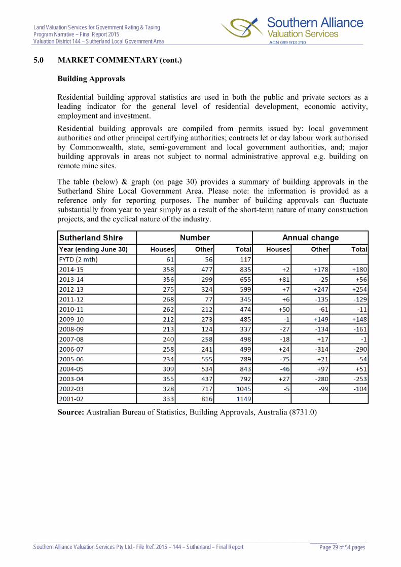
5.0 MARKET COMMENTARY (cont.)
Building Approvals
Residential building approval statistics are used in both the public and private sectors as a leading indicator for the general level of residential development, economic activity, employment and investment.
Residential building approvals are compiled from permits issued by: local government authorities and other principal certifying authorities; contracts let or day labour work authorised by Commonwealth, state, semi-government and local government authorities, and; major building approvals in areas not subject to normal administrative approval e.g. building on remote mine sites.
The table (below) & graph (on page 30) provides a summary of building approvals in the Sutherland Shire Local Government Area. Please note: the information is provided as a reference only for reporting purposes. The number of building approvals can fluctuate substantially from year to year simply as a result of the short-term nature of many construction projects, and the cyclical nature of the industry.
Source: Australian Bureau of Statistics, Building Approvals, Australia (8731.0)

Land Valuation Services for Government Rating & Taxing Program Narrative – Final Report 2015 Valuation District 144 – Sutherland Local Government Area
___________________________________________________________________________________________________ Page 30 of 54 pages Southern Alliance Valuation Services Pty Ltd - File Ref: 2015 – 144 – Sutherland – Final Report
5.0 MARKET COMMENTARY (cont.)
A “House” is defined as: “A detached building primarily used for long term residential purposes consisting of one dwelling unit. Includes detached residences associated with a non-residential building, and kit and transportable homes”. Whist “other residential building” is defined as: “Buildings other than houses which are primarily used for long-term residential purposes. Other residential buildings includes: semidetached, row or terrace houses or townhouses; and flats, units or apartments”.
Commercial/Retail - Sales analysis of commercial / retail property within the Sutherland Shire Local Government Area for Base Date 2015 showed moderate growth generally ranging between 8% up to 23% depending on location and development potential. Commercial sites with mixed use potential generally experienced the strongest growth as a result of Sydney’s surging residential market. Business / Retail sites situated in close proximity to railway stations generally performed well throughout the LGA, whilst sites formerly classified as “Employment” experienced more modest increases in line with Industrial value movements. Industrial - Sales analysis of industrial property within the Sutherland Shire Local Government Area showed some modest growth after a few years of stagnation, recording increases ranging generally between 5-10% from their prior Base Date levels.

Land Valuation Services for Government Rating & Taxing Program Narrative – Final Report 2015 Valuation District 144 – Sutherland Local Government Area
___________________________________________________________________________________________________ Page 31 of 54 pages Southern Alliance Valuation Services Pty Ltd - File Ref: 2015 – 144 – Sutherland – Final Report
6.0 METHODOLOGY, MANAGEMENT OF COMPONENTS, BENCHMARKS & HANDCRAFTING
Valuation Methodology
The component mass valuation methodology, as defined in the Valuer General’s Office
Revised Procedure Manual for the Provision of Values was applied.
Handcrafting however was necessary in identified areas / categories to ensure the correct value levels / relationships were applied, in addition to ensuring changes to zones or building codes which had an effect on values or which changed the inter-se relationship of prior Base Date valuations levels.
Components / Benchmarks
Following completion of the 2014 Valuation Program and during the course of the 2015 Valuation program, Southern Alliance Valuation Services continues to undertake investigations either by components reviews, verification and supplementary workflow actions to identify (with the assistant of ValMap) and correctly relocate properties into their appropriate homogenous components or groupings in addition to reviewing land value levels of those re-located properties ensuring they are correctly valued. Component structures and benchmarks are constantly under review to ensure that they fit within desirable parameters according to market movements. ValMap continues to be used to identify properties that are incorrectly zoned and/or componentised. Eg: individual properties that were outside or not within their homogenous or best suited groupings, which have led or may lead to a distortion of value levels as a result of the application of factors over time. Handcrafting
In addition to the above, handcrafting/re-grading was also undertaken, where necessary in various areas throughout the Local Government Area.
To ensure consistency and the adoption of market value based levels, the following properties have been handcrafted, but limited to:
1. major active recreational properties, ie: golf courses, marinas, recreational land comprising licensed clubs / sports related premises,
2. special rating type properties, ie: service stations, fast food outlets, regional and sub-
regional shopping centres, heritage properties and
3. special use type properties, ie: Police Stations, emergency services etc.

Land Valuation Services for Government Rating & Taxing Program Narrative – Final Report 2015 Valuation District 144 – Sutherland Local Government Area
___________________________________________________________________________________________________ Page 32 of 54 pages Southern Alliance Valuation Services Pty Ltd - File Ref: 2015 – 144 – Sutherland – Final Report
6.0 METHODOLOGY, MANAGEMENT OF COMPONENTS, BENCHMARKS & HANDCRAFTING (cont.)
Verification
As part of Southern Alliance Valuation Services contract with the Department of Lands and the Valuer General, the following have been verified to ensure correctness of values.
100% of risk rating 1 properties have been verified
33% of risk rating 2 properties have been verified
19% out of the required 16.67% of risk rating 3 properties have been verified
The components that have been verified within the Sutherland Local Government Area during the 2015 program include (but is limited to):
Residential Components - HAR (95.3%), NYB (88.3%), HRH (94.7%), WFA (76.4%), HAC (79.9%), HCO (86.4%), HGB (88.8%), WFC (83.8%) and re-grading throughout a selection of entries in the remaining components. Business Components – BRD (84.9%), BRB (77.7%) and re-grading throughout a selection of entries in the remaining components.
Industrial Components – INA (69.1%), INH (73.5%), INI (76.9%) and re-grading throughout a selection of entries in a number of components. Miscellaneous Component – PCR (92.0%) and re-grading throughout a selection of entries in all components.
This verification process is critical due to limitations in the mass valuation techniques,
particularly over a period of time. The continued application of component factors may have led to a distortion in the relativity of values within a geographical area. Some types of properties are so few in number or likely to be so sensitive to localised changes that handcrafting values is the only appropriate method.
The process encompasses checking the factored values to ensure that they are not outside the
range that is supported by the sales evidence analysed. This process includes physical inspection and the use of local knowledge obtained from previous inspections or other sources. Other applications used to assist in the verification process included the Valmap system, a computer application used to search and display linked valuation and spatial data.

Land Valuation Services for Government Rating & Taxing Program Narrative – Final Report 2015 Valuation District 144 – Sutherland Local Government Area
___________________________________________________________________________________________________ Page 33 of 54 pages Southern Alliance Valuation Services Pty Ltd - File Ref: 2015 – 144 – Sutherland – Final Report
7.0 VALUE LEVELS AND MOVEMENTS
On the analysed sales evidence available per the schedules & individual analysis reports, the amount of variation applied from land value levels from Base Date 1 July 2014 to Base Date 1 July 2015 in each zone category / component is summarised as follows: Residential – Zones E3, E4, R2, R3 & R4
Sixty Nine (69) Residential Single Dwelling Components (excl. Waterfronts below) (51,511 valuations) - representing the majority of the LGA.
One (1) component recorded nil variation with the exception of verified and handcrafted properties.
Two (2) components recorded variations greater than 5% but less than or equal to 10% with the exception of verified and handcrafted properties. Fifteen (15) components recorded variations greater than 10% but less than or equal to 15% with the exception of verified and handcrafted properties. Twenty Two (22) components recorded a variation greater than 15% but less than or equal to 20% with the exception of verified and handcrafted properties.
Sixteen (16) components recorded a variation greater than 20% but less than or equal to 25% with the exception of verified and handcrafted properties.
Ten (10) components recorded a variation greater than 25% but less than or equal to 30% with the exception of verified and handcrafted properties. Three (3) components recorded a variation greater than 30% but less than or equal to 35% with the exception of verified and handcrafted properties.
Fifteen (15) Residential Waterfront Components (3,290 valuations).
Two (2) components recorded variations greater than 5% but less than or equal to 10% with the exception of verified and handcrafted properties.
Eight (8) components recorded a variation greater than 10% but less than or equal to 15% with the exception of verified and handcrafted properties. Two (2) components recorded variations greater than 15% but less than or equal to 20% with the exception of verified and handcrafted properties. One (1) component recorded variations greater than 20% but less than or equal to 25% with the exception of verified and handcrafted properties. Two (2) components recorded variations greater than 25% but less than or equal to 30% with the exception of verified and handcrafted properties.

Land Valuation Services for Government Rating & Taxing Program Narrative – Final Report 2015 Valuation District 144 – Sutherland Local Government Area
___________________________________________________________________________________________________ Page 34 of 54 pages Southern Alliance Valuation Services Pty Ltd - File Ref: 2015 – 144 – Sutherland – Final Report
7.0 VALUE LEVELS AND MOVEMENTS (cont.) Two (2) Residential Englobo Components (21 valuations). One (1) component recorded nil variation with the exception of verified and handcrafted properties. One (1) component recorded a variation greater than 15% but less than or equal to 20% with the exception of verified and handcrafted properties.
Eight (8) Residential Density Components (Medium & High Density) (2,145 valuations).
Five (5) components recorded a variation greater than 15% but less than or equal to 20% with the exception of verified and handcrafted properties. Three (3) components recorded a variation greater than 20% but less than or equal to 25% with the exception of verified and handcrafted properties.
Business – Zones B1, B2, B3, B4, B5, B6 & B7 Twenty One (21) Business Components (1,415 valuations).
Four (4) components recorded a variation greater than 5% but less than or equal to 10% with the exception of verified and handcrafted properties. Ten (10) components recorded a variation greater than 10% but less than or equal to 15% with the exception of verified and handcrafted properties. Five (5) components recorded a variation greater than 15% but less than or equal to 20% with the exception of verified and handcrafted properties. One (1) component recorded a variation greater than 20% but less than or equal to 25% with the exception of verified and handcrafted properties. One (1) component recorded a variation greater than 45% but less than or equal to 50% with the exception of verified and handcrafted properties.

Land Valuation Services for Government Rating & Taxing Program Narrative – Final Report 2015 Valuation District 144 – Sutherland Local Government Area
___________________________________________________________________________________________________ Page 35 of 54 pages Southern Alliance Valuation Services Pty Ltd - File Ref: 2015 – 144 – Sutherland – Final Report
7.0 VALUE LEVELS AND MOVEMENTS (cont.)
Industrial – Zones IN1, IN2, IN3 & IN4 Sixteen (16) Industrial Components (660 valuations).
Three (3) components recorded nil variation, with the exception of verified and handcrafted properties. Six (6) components recorded a variation greater than 0% but less than or equal to 5% with the exception of verified and handcrafted properties. Six (6) components recorded a variation greater than 5% but less than or equal to 10% with the exception of verified and handcrafted properties. One (1) component recorded a variation greater than 35% but less than or equal to 40% with the exception of verified and handcrafted properties.
Open Space – Zones E1, E2, RE1, RE2, W1 & W2
Seven (7) Open Space Components (1,331 valuations).
All seven (7) components recorded nil variation, with the exception of verified and handcrafted properties.
Special Uses – Zones SP1, SP2 & SP3
Four (4) Special Use Components (513 valuations).
All four (4) components recorded a variation greater than 20% but less than or equal to 25% with the exception of verified and handcrafted properties.
In addition to applying the component variation factors within each zone and component, secondary factors and / or individual handcrafting were applied for minor mass valuation adjustments eg: whole street adjustments which differed in variation to the primary component factor.

Land Valuation Services for Government Rating & Taxing Program Narrative – Final Report 2015 Valuation District 144 – Sutherland Local Government Area
___________________________________________________________________________________________________ Page 36 of 54 pages Southern Alliance Valuation Services Pty Ltd - File Ref: 2015 – 144 – Sutherland – Final Report
7.0 VALUE LEVELS AND MOVEMENTS (cont.)
Value Levels – Typical Properties
The examples below are a narrow selection of typical properties with their respective value levels. For a comprehensive representation of Typical Properties and their value levels and factors throughout the Local Government Area, please refer to the Component & Benchmarks Tables annexed to this report.
Table of typical land values (sample only):
Single Residential
Suburb Region & Site Area
2014 LV GV
2014 LV LT
2015 LV LT
2014-2015 Variation
Cronulla South (5 Gardenia St)
Coastal 552m2
$1,200,000 $1,200,000 $1,450,000 +20.9%
Miranda (35 Violet St)
Inland 575m2
$680,000 $680,000 $780,000 +14.8%
Sutherland (19 Oakwood St)
Inland-West 696m2
$566,000 $566,000 $740,000 +30.8%
Menai (12 Carmarthen St)
Western 678m2
$608,000 $608,000 $695,000 +14.4%
Engadine (35 Poulter Ave)
South Western 556m2
$510,000 $510,000 $615,000 +20.6%
Caringbah South (422 Willarong Rd)
Waterfront 1,164m2
$1,450,000 $1,450,000 $1,600,000 +10.4%
Sylvania Waters (32 Castlereagh Cr)
Waterfront 664m2
$1,440,000 $1,440,000 $1,700,000 +18.1%
Woronora (137 Prices Cct)
Waterfront 841m2
$841,000 $841,000 $925,000 +10.0%
Residential Density
Suburb Site Area 2014 LV
GV 2014 LV
LT 2015 LV
LT 2014-2015 Variation
Gymea (86-88 Manchester Rd)
Medium Den 1,209m2
4 @ 302m2 each
$1,480,000 $1,224/m2
$370,000/site
$1,480,000 $1,224/m2
$370,000/site
$1,750,000 $1,447/m2
$437,500/site +18.3%
Caringbah (3-5 Curtis St)
High Density 1,631m2
15 @ 109m2 each
$2,110,000 $1,294/m2
$140,667/site
$2,110,000 $1,294/m2
$140,667/site
$2,550,000 $1,563/m2
$170,000/site +20.9%
Sutherland (860 Old Princes Hwy)
Mixed (Bus / Res)
980m2
$1,800,000 $1,837/m2
$1,800,000 $1,837/m2
$2,200,000 $2,245/m2
+22.3%

Land Valuation Services for Government Rating & Taxing Program Narrative – Final Report 2015 Valuation District 144 – Sutherland Local Government Area
___________________________________________________________________________________________________ Page 37 of 54 pages Southern Alliance Valuation Services Pty Ltd - File Ref: 2015 – 144 – Sutherland – Final Report
7.0 VALUE LEVELS AND MOVEMENTS (cont.)
Business
Suburb Site Area &
Frontage 2014 LV
GV 2014 LV
LT 2015 LV
LT 2014-2015 Variation
Cronulla (45 Cronulla St)
186m2 6.1m
$1,350,000 $221,311/lm
ftge
$1,350,000 $221,311/lm
ftge
$1,600,000 $262,295/lm
ftge +18.6%
Caringbah (329 Kingsway)
221m2 6.1m
$660,000 $108,197/lm
ftge
$660,000 $108,197/lm
ftge
$760,000 $124,590/lm
ftge +15.2%
Kirrawee (152 Oak Rd)
259m2 6.1m
$365,000 $59,836/lm ftge
$365,000 $59,836/lm ftge
$410,000 $67,213/lm ftge
+12.4%
Industrial
Suburb Site Area 2014 LV
GV 2014 LV
LT 2015 LV
LT 2014-2015 Variation
Taren Point (45 Bay Rd) 4,018m2 $2,500,000
$622/m2 $2,500,000
$622/m2 $2,650,000
$660/m2 +6.0%
Kirrawee (102-106 Bath Rd) 4,598m2 $2,150,000
$468/m2 $2,150,000
$468/m2 $2,250,000
$489/m2 +5.0%

Land Valuation Services for Government Rating & Taxing Program Narrative – Final Report 2015 Valuation District 144 – Sutherland Local Government Area
___________________________________________________________________________________________________ Page 38 of 54 pages Southern Alliance Valuation Services Pty Ltd - File Ref: 2015 – 144 – Sutherland – Final Report
7.0 VALUE LEVELS AND MOVEMENTS (cont.)

Land Valuation Services for Government Rating & Taxing Program Narrative – Final Report 2015 Valuation District 144 – Sutherland Local Government Area
___________________________________________________________________________________________________ Page 39 of 54 pages Southern Alliance Valuation Services Pty Ltd - File Ref: 2015 – 144 – Sutherland – Final Report
7.0 VALUE LEVELS AND MOVEMENTS (cont.)
The preferred and primary approach for time adjustment in the Sutherland Shire LGA is to use evidence of sales and re-sales or sales of like properties at different dates.
Examples of Sale and Resales within the Sutherland Shire LGA:
Residential: 191 Attunga Rd Yowie Bay Sold 12/04/14 - $1,320,000 Resold 05/05/15 - $1,778,000 Shows 34.70% increase 30 Auburn St Sutherland Sold 29/01/14 - $713,000 Resold 14/08/15 - $932,000 Shows 30.72% increase
25 Bangalee Pl Bangor Sold 14/12/2013 - $550,000 Resold 12/06/2015 - $725,000 Shows 31.82% increase
110 Carina Rd Oyster Bay Sold 17/03/14 - $715,000 Resold 11/06/15 - $800,000 Shows 11.89% increase
92 Edward St Sylvania Sold 07/10/14 - $1,100,000 Resold 20/10/15 - $1,390,000 Shows 26.36% increase 16 Foreman Pl Barden Ridge Sold 14/01/14 - $465,000 Resold 30/05/15 - $660,000 Shows 41.94% increase 38 Lantana Rd Engadine Sold - 17/11/14 - $650,000 Resold 21/03/15 - $697,250 Shows 7.27% increase 4 Lenna Pl Jannali Sold 21/12/2013 - $550,000 Resold 04/02/2015 - $625,000 Shows 13.64% increase
4 Lochness Pl Engadine Sold - 03/06/14 - $930,000 Resold 18/03/15 - $980,000 Shows 5.38% increase 11 Lowry Pl Woronora Sold 18/09/14 - $855,000 Resold 04/07/15 - $980,000 Shows 14.62% increase 10 Magellan Way Kurnell Sold 23/12/14 - $663,000 Resold 27/07/15 - $820,000 Shows 23.68% increase 154 National Ave Loftus Sold 15/07/14 - $740,000 Resold 23/06/15 - $900,000 Shows 21.62% increase 221 Princes Hwy Sylvania Sold 08/02/14 - $792,500 Resold 29/04/15 - $902,000 Shows 13.82% increase 9 Roper Cres Sylvania Waters Sold 17/04/14 - $1,200,000 Resold 07/03/15 - $1,441,000 Shows 20.08% increase

Land Valuation Services for Government Rating & Taxing Program Narrative – Final Report 2015 Valuation District 144 – Sutherland Local Government Area
___________________________________________________________________________________________________ Page 40 of 54 pages Southern Alliance Valuation Services Pty Ltd - File Ref: 2015 – 144 – Sutherland – Final Report
7.0 VALUE LEVELS AND MOVEMENTS (cont.)
289-291 The Boulevarde Miranda Sold 23/11/2013 - $1,415,000 Resold 17/03/2015 - $1,825,000 Shows 28.98% increase
18 Thurlgona Rd Engadine Sold 08/08/14 - $835,000 Resold 13/03/15 - $885,000 Shows 5.99% increase 17 Warabin St Waterfall Sold 03/07/14 - $520,000 Resold 06/06/15 - $630,000 Shows 21.15% increase 375A Woolooware Rd Burraneer Sold 22/11/14 - $1,880,000 Resold 23/04/15 - $2,175,000 Shows 15.69% increase 138 Woronora Cres Como Sold 20/03/14 - $879,500 Resold 11/07/15 - $1,410,000 Shows 60.32% increase
Please note: The above examples excludes non market transactions and sales which have been redeveloped, however may include sales which have had minor renovation (generally cosmetic) considered to add nominal value overall.

Land Valuation Services for Government Rating & Taxing Program Narrative – Final Report 2015 Valuation District 144 – Sutherland Local Government Area
___________________________________________________________________________________________________ Page 41 of 54 pages Southern Alliance Valuation Services Pty Ltd - File Ref: 2015 – 144 – Sutherland – Final Report
8.0 TOTAL LAND VALUE VARIATIONS

Land Valuation Services for Government Rating & Taxing Program Narrative – Final Report 2015 Valuation District 144 – Sutherland Local Government Area
___________________________________________________________________________________________________ Page 42 of 54 pages Southern Alliance Valuation Services Pty Ltd - File Ref: 2015 – 144 – Sutherland – Final Report
8.0 TOTAL LAND VALUE VARIATIONS (cont.)

Land Valuation Services for Government Rating & Taxing Program Narrative – Final Report 2015 Valuation District 144 – Sutherland Local Government Area
___________________________________________________________________________________________________ Page 43 of 54 pages Southern Alliance Valuation Services Pty Ltd - File Ref: 2015 – 144 – Sutherland – Final Report
8.0 TOTAL LAND VALUE VARIATIONS (cont.)

Land Valuation Services for Government Rating & Taxing Program Narrative – Final Report 2015 Valuation District 144 – Sutherland Local Government Area
___________________________________________________________________________________________________ Page 44 of 54 pages Southern Alliance Valuation Services Pty Ltd - File Ref: 2015 – 144 – Sutherland – Final Report
8.0 TOTAL LAND VALUE VARIATIONS (cont.)

Land Valuation Services for Government Rating & Taxing Program Narrative – Final Report 2015 Valuation District 144 – Sutherland Local Government Area
___________________________________________________________________________________________________ Page 45 of 54 pages Southern Alliance Valuation Services Pty Ltd - File Ref: 2015 – 144 – Sutherland – Final Report
8.0 TOTAL LAND VALUE VARIATIONS (cont.)

Land Valuation Services for Government Rating & Taxing Program Narrative – Final Report 2015 Valuation District 144 – Sutherland Local Government Area
___________________________________________________________________________________________________ Page 46 of 54 pages Southern Alliance Valuation Services Pty Ltd - File Ref: 2015 – 144 – Sutherland – Final Report
9.0 ADDED VALUE OF IMPROVEMENTS Residential:
In addition to vacant land sales, improved sales were used to assist in determining the market levels for land values and to negate any possibility of a scarcity factor. The Paired Sales Approach was used throughout the Sutherland Shire whereby the land value demonstrated by vacant land sales is to be taken from the sale price of improved properties to determine the added value of the improvements.
The table below details the results from this analysis for the Sutherland Shire valuation area. The schedule provided is general in nature and each analysed sale is assessed individually when determining the added value of improvements to capture specific features e.g. quality of renovations, design/layout, landscaping, no. of levels, topography etc.
Property Type Condition Added Value of Improvements
0 to 12 month life expectancy Dilapidated condition. Nil to $50,000
($0m2 to $600m2)
Fibrous Cement & Permalum Clad dwellings. Generally 2-3 bedrooms. Circa 1940’s to 1960.
Fair to Good condition. $50,000 to $100,000
($500m2 to $1,000m2)
Fibrous Cement & Permalum Clad dwellings. Generally 2-3 bedrooms. Circa 1940’s to 1960.
Good / Renovated Condition.
$80,000 to $130,000
($700m2 to $1,200m2)
Brick dwellings. Generally 2-3 bedrooms. Circa 1930’s to 1970.
Fair to Good Condition. $70,000 to $120,000
($600m2 to $1,100m2)
Brick dwellings. Generally 2-3 bedrooms. Circa 1930’s to 1970.
Good / Renovated Condition.
$100,000 - $150,000
($800m2 to $1,300m2)
Brick dwellings. Generally 3-5 bedrooms. Circa 1930’s to 1970.
Fair to Good Condition. $90,000 to $150,000
($600m2 to $1,100m2)
Brick dwellings. Generally 3-5 bedrooms. Circa 1930’s to 1970.
Good / Renovated Condition.
$150,000 - $200,000
($1,000m2 to $1,300m2)
Brick dwellings. Generally 3-5 bedrooms. Circa 1970’s to 1990.
Fair to Good Condition. $120,000 - $230,000
($800m2 to $1,250m2)
Brick dwellings. Generally 3-5 bedrooms. Circa 1970’s to 1990.
Good / Renovated Condition.
$200,000 - $300,000
($1,000m2 to $1,500m2)
Brick dwellings. Generally 3-6 bedrooms. Modern Construction. Typically Project Homes.
Good Condition. $250,000 - $400,000
($1,200m2 to $1,750m2)
Brick dwellings. Generally 3-6 bedrooms. Modern Construction. Architect Designed.
Good Condition. $300,000 - $450,000 +
($1,500m2 +)

Land Valuation Services for Government Rating & Taxing Program Narrative – Final Report 2015 Valuation District 144 – Sutherland Local Government Area
___________________________________________________________________________________________________ Page 47 of 54 pages Southern Alliance Valuation Services Pty Ltd - File Ref: 2015 – 144 – Sutherland – Final Report
9.0 ADDED VALUE OF IMPROVEMENTS (cont.)
Examples of paired analysis within the Sutherland LGA:
1) 4 Lenna Pl Jannali Sold $625,000 February 2015 – 19.96/ x 27.97 (556.40m2) Essentially vacant land. Sale includes detached single garage (nil added value). Deduced LV $625,000. Adopt adjusted LV @ BD 2015, As $650,000
Paired with: 135 Wattle Rd Jannali Sold $1,020,000 May 2015 – 15.85/ x 37.19 (581.70m2) Improved: Two storey 4-5 bedroom circa 1970’s brick dwelling with tile roof. Renovated kitchen. Double lock-up garage UMR. Average condition overall. GBA 230m2 approx (including DLUG). Externally there is an in ground swimming pool and single carport. Analysed & adjusted LV @ BD 2015 in comparison, adopt $715,000 (superior location) Added value of residence equates to $270,000 ($1,174/m2) + $35,000 for in ground pool, carport, fencing, landscaping, driveway & paths.
Paired with: 36 Glendale Pl Jannali Sold $920,000 April 2015 – 17.915 Irr/17.015 Irr x 35.88 Irr/33.23 (576.40m2) Improved: Two storey 4 bedroom circa 1980’s brick dwelling with tile roof. Single lock-up garage with internal access. Average condition overall. GBA 190m2 approx (including SLUG). Analysed & adjusted LV @ BD 2015 in comparison, adopt $700,000 (superior location) Added value of residence equates to $220,000 ($1,158/m2). 2) 22 Forest Rd Heathcote Sold $740,000 June 2015 – 13.715 x 40.24(551.90m2) Vacant land. Less market adjustments $75,000. Deduced LV $665,000. Adopt adjusted LV @ BD 2015, As $665,000
Paired with: 2 Henry Kendall Cl Heathcote Sold $885,000 July 2015 – 27.76/31.99 x 17.87Irr/16.74 (596.30m2) Improved: Two storey 3 bedroom circa 1990’s double brick dwelling with tile roof. Double lock-up garage with internal access. Good condition overall. GBA 190m2 approx (including DLUG). Analysed & adjusted LV @ BD 2015 in comparison, adopt $640,000 (inferior location) Added value of residence equates to $230,000 ($1,211/m2) + $15,000 for fencing, landscaping, driveway & paths.
Paired with: 3A Jacana Gr Heathcote Sold $1,050,000 September 2015 – 15.24 x 40.23 (607.00m2) Improved: Two storey 4-5 bedroom circa 1980’s brick dwelling with tile roof presenting in good condition overall. GBA 220m2 approx. Externally there is a detached four car garage with workshop (approx. 80m2). Analysed & adjusted LV @ BD 2015 in comparison, adopt $700,000 (wider frontage) Added value of residence equates to $300,000 ($1,364/m2) + $50,000 for detached garage, fencing, landscaping, driveway & paths.

Land Valuation Services for Government Rating & Taxing Program Narrative – Final Report 2015 Valuation District 144 – Sutherland Local Government Area
___________________________________________________________________________________________________ Page 48 of 54 pages Southern Alliance Valuation Services Pty Ltd - File Ref: 2015 – 144 – Sutherland – Final Report
9.0 ADDED VALUE OF IMPROVEMENTS (cont.)
3) 4 Renard Cl Illawong Sold $750,000 March 2015 – 21.88 Irr/21 x 29.44/34.44 (682.70m2) Vacant land. Deduced LV $750,000. Adopt adjusted LV @ BD 2015, As $750,000
Paired with: 194 Fowler Rd Illawong Sold $1,340,000 March 2015 – 20 x 35 (700.00m2) Improved: Three storey circa early 1990’s brick dwelling with tile roof. Accommodation generally consists of 4 bedrooms, 4 bathrooms and a DLUG UMR. Mostly original & well maintained throughout. Good condition overall. GBA 385m2 approx (including DLUG). Externally there is an in ground pool. Analysed & adjusted LV @ BD 2015 in comparison, adopt $750,000 Added value of residence equates to $520,000 ($1,351/m2) + $70,000 for in ground pool, verandahs, balconies, pergolas, fencing, landscaping, driveway & paths.
Paired with: 198 Fowler Rd Illawong Sold $1,360,000 March 2015 – 20 x 35 (700.00m2) Improved: Three storey circa early 1990’s brick dwelling with tile roof. Accommodation generally consists of 5 bedrooms, 3 bathrooms and a DLUG UMR. Mostly original & well maintained throughout. Good condition overall. GBA 380m2 approx (including DLUG). Externally there is an in ground pool. Analysed & adjusted LV @ BD 2015 in comparison, adopt $750,000 Added value of residence equates to $525,000 ($1,382/m2) + $85,000 for in ground pool, verandahs, balconies, fencing, landscaping, driveway & paths.
4) 66 Moyran Pde Grays Point Sold $750,000 June 2015 – 16.51/HWM x 111.71/112.01 (1,834.00m2) Vacant land. Sold without DA Approval. Deduced LV $750,000. Adopt LV @ BD 2015, As $750,000 Paired with: 74 Moyran Pde Grays Point Sold $1,005,000 March 2015 – 15.62/HWM x 102.72/104.85 (1,777.00m2) Improved: Two storey 3 bedroom brick veneer dwelling with tile roof. Circa 1960’s. Good condition. Renovated. GBA 200m2 approx (including balconies). Single carport. Analysed LV @ BD 2015 in comparison, adopt $750,000. Added value of residence equates to $230,000 ($1,150/m2) + $25,000 carport, landscaping, fencing, driveway & paths.

Land Valuation Services for Government Rating & Taxing Program Narrative – Final Report 2015 Valuation District 144 – Sutherland Local Government Area
___________________________________________________________________________________________________ Page 49 of 54 pages Southern Alliance Valuation Services Pty Ltd - File Ref: 2015 – 144 – Sutherland – Final Report
9.0 ADDED VALUE OF IMPROVEMENTS (cont.)
5) 36 Dilkara Cct Bangor Sold $610,000 April 2015 – 20 x 37.46 (749.10m2) Vacant land. Deduced LV $610,000. Adopt adjusted LV @ BD 2015, As $610,000
Paired with: 22 Belarada Cl Bangor Sold $865,000 February 2015 – 18.06/18.2 x 37.52/39.73 (697.40m2) Improved: Two storey circa early 1980’s brick dwelling with tile roof. Accommodation generally consists of 4 bedrooms, 2 bathrooms and a DLUG UMR. Average, mostly original condition. GBA 220m2 approx (including DLUG). Analysed & adjusted LV @ BD 2015 in comparison, adopt $640,000 Added value of residence equates to $200,000 ($909/m2) + $25,000 for, verandahs, pergola, fencing, landscaping, driveway & paths.
Paired with: 71 Yala Rd Bangor Sold $875,000 April 2015 – 18.39/18.5 x 36.93/39 (698.00m2). Improved: Single storey circa early 1980’s brick dwelling with tile roof. Accommodation generally consists of 4 bedrooms, 2 bathrooms and an attached DLUG. Partly renovated. Modern bathroom. Original kitchen. GBA 190m2 approx (including DLUG). Analysed & adjusted LV @ BD 2015 in comparison, adopt $655,000 Added value of residence equates to $205,000 ($1,079/m2) + $15,000 for fencing landscaping, driveway & paths.

Land Valuation Services for Government Rating & Taxing Program Narrative – Final Report 2015 Valuation District 144 – Sutherland Local Government Area
___________________________________________________________________________________________________ Page 50 of 54 pages Southern Alliance Valuation Services Pty Ltd - File Ref: 2015 – 144 – Sutherland – Final Report
9.0 ADDED VALUE OF IMPROVEMENTS (cont.)
Commercial / Retail / Industrial: Due to the lack of sufficient vacant land sales in the Sutherland LGA for the above zone categories, the Replacement Cost approach was applied when analysing sales evidence. The Replacement Cost approach is based upon the principle that the informed purchaser would pay no more than the cost to reproduce the sale property. Hence the methodology used on analysis is as follows:
Replacement Cost Methodology: Reasonable allowance for refurbishment costs added to the sale price to bring the
improvements to an as new replacement standard where the returns would be equivalent to as new.
An appropriate entrepreneurial profit and risk allowance. On average between 10% – 15%
in the Sutherland Valuation Area.
Allowance for interest on funds during the hypothetical construction to completion period. This is inclusive of holding charges and construction costs. Depending on borrowings between 7% - 9% was applied.
The adjusted sale price can now be analysed for land content by using industry accepted
cost estimates for the as new building and development expenses. As a general summary, the cost new applied in the Sutherland LGA were as follows:
Single storey retail shop $ 900 m2 - $1,000 m2 GBA Two storey retail shop with office above $1,000 m2 - $1,500 m2 GBA Two storey retail shop with residential above $1,500 m2 - $2,000 m2 GBA Industrial (depending on construction type) $ 500 m2 - $1,000 m2 GBA The residual amount following this exercise will show the adjusted land value at the base date.
Other costs accounted for are:
All professional fees Costs of site works in preparation for building Cost of stamp duty and legal charges on purchase of site Costs of rates and taxes over development period Loss of interest on capital outlaid on purchase of site Loss of interest on capital outlaid on construction (av. 50% of dev. period). Legal costs and commission on sale for development sites. Critical to the analysis is that the added value only is to be captured and taken from the Sale Price to show the Residual Land Value.

Land Valuation Services for Government Rating & Taxing Program Narrative – Final Report 2015 Valuation District 144 – Sutherland Local Government Area
___________________________________________________________________________________________________ Page 51 of 54 pages Southern Alliance Valuation Services Pty Ltd - File Ref: 2015 – 144 – Sutherland – Final Report
10.0 DETAILS OF OTHER ANCILLARY SERVICES Supplementary Action & Objections / Land and Environmental Court Decisions
Supplementary valuations are ongoing ensuring the correctness / continual update of the Register of Land Values. During the period May 2003 to November 2015, SAVS achieved an average supplementary completion turnaround of 9.63 days from a required 30 days (average of 20 days). Regard was and continues to be given to prior Base Date land values altered by objection by the Valuer-General / Department of Lands and / or the Land and Environment Court. This included analysis of the objection results, grading checks and handcrafting on surrounding properties / areas to ensure the altered value levels are filtered throughout property with similar characteristics / comparability.
Analysis of the Sutherland 2014 General Valuation register of land values reveal that approximately 36 Base Date 1 July 2014 Land Values were altered by objections including Land and Environmental Court decisions. Analysis of the Sutherland 2014 Land Tax Valuation register of land values reveal that approximately 36 Base Date 1 July 2014 Land Values were altered by objections including Land and Environmental Court decisions.
Local Council Development Applications, Approvals / Consent.
A register has been maintained since early 1997 reporting on approved Development / Building Applications.
Progress Reports & Meetings
Southern Alliance Valuation Services and Department of Lands Contract Manager(s) regularly meet, particularly during the program period, to discuss issues eg: analysed sales, minor and significant changes & trends, media focus, components, benchmarks, development consents and to monitor progress and targets.
Valuation Entry details other than Land Values
Those properties that were or in future identified as having incorrect zonings, component codes, dimensions, site areas, legal description, street address, etc, have and continue to be altered or amended to show correct register of land value details. Such changes were / will continue to be reported to LPI’s Contract & Land Data Managers on an ongoing basis.
Additional Analysed Sales Additional analysed sales will be supplied to the Valuer-General / Department of Lands on an ongoing basis.
Changes to Legislative, Procedure and System Changes since commencement of contract.
Amended Rating and Taxing Valuations Procedures Manual Version 6.6.2 (approved 20th October 2014, effective 1st March 2015).

Land Valuation Services for Government Rating & Taxing Program Narrative – Final Report 2015 Valuation District 144 – Sutherland Local Government Area
___________________________________________________________________________________________________ Page 52 of 54 pages Southern Alliance Valuation Services Pty Ltd - File Ref: 2015 – 144 – Sutherland – Final Report
11.0 QUALITY ASSURANCE
In accordance with Southern Alliance Valuation Services Pty Ltd own internal QA manual and the Office of the Valuer General guidelines, the following quality checks have been made in the delivery of services.
Ensuring all properties have been valued.
Ensuring the valuations are within the set parameters.
That a zone/component code integrity check has been made.
An in depth value check on those properties that have considerably higher values in relation
to the average for land.
Ensure that current and proposed Development Control Plans and planning changes that affect the valuations have been taken into account.
Where the land value of a property has been amended on objection, the alignment of values with nearby properties has been checked.
That all Statutory concession valuations and allowances have been supplied, including –
Allowances for development on and off the land
Heritage Values
Land Rating Factors
Apportionment of Values
Mixed Development Apportionment Factors The following statistical checks have been carried out for all zoned properties.
Coefficient of Dispersion (COD)
This measures the relative consistency and, when viewed with the other measures, the relative accuracy of values in relation to the sales. It shows the amount of variation or the consistency of the values and also the relative accuracy of the values as the relationship between values and sales widens.
The accepted measure for the COD is 0 – 15.
Mean Value to Price Ratio (MVP)
This calculates the mean relative accuracy, or level of values, relative to the sales. It shows the mean level of accuracy of the values assigned compared to the sales evidence. The MVP is to be calculated only in single dwelling residential categories, including rural home site areas.
The accepted measure for the MVP is 85-100%.

Land Valuation Services for Government Rating & Taxing Program Narrative – Final Report 2015 Valuation District 144 – Sutherland Local Government Area
___________________________________________________________________________________________________ Page 53 of 54 pages Southern Alliance Valuation Services Pty Ltd - File Ref: 2015 – 144 – Sutherland – Final Report
11.0 QUALITY ASSURANCE (cont.)
Price Related Differential (PRD)
This test measures the progressive value to sale relativity across the range of values in the sample. It demonstrates the variations of relativity between the sales and the assigned values and indicates if there is a progressive change in relativity across the value range.
The accepted measure for the PRD is 0.98 – 1.03.
Refer to the Valuation Analysis Report for the results, from all sales analysed, excluding those considered to be outliers, ie: out of line in comparison to other sales.
Land Valuation Services for Government Rating & Taxing Program Narrative – Final Report 2015 Valuation District 144 – Sutherland Local Government Area
___________________________________________________________________________________________________ Page 54 of 54 pages Southern Alliance Valuation Services Pty Ltd - File Ref: 2015 – 144 – Sutherland – Final Report
12.0 PURPOSE OF THIS REPORT
The purpose of this report is to describe the process and considerations for the 1 July 2015 general valuation of the Sutherland Local Government Area. The report has been produced on behalf of the Valuer General. The land values have been specifically made for rating and taxing purposes. Land values produced as part of this process should not be used for any other purpose without the specific agreement of the Valuer General. Land values must have regard to specific requirements and assumptions in rating and taxing legislation. Consequently these valuations may vary from market levels. The land values have been determined using a methodology prescribed by the Rating and Taxing Valuation Procedures Manual. The Manual allows mass valuation methodologies that involve assessing large numbers of properties as a group, to be utilised where appropriate. Mass valuation methodologies are, by their nature, likely to be less accurate than individually assessed valuations, however, are utilised worldwide for rating and taxing purposes to deliver valuations within an acceptable market range. Town planning, land use and other market information contained in this report has been compiled based on enquiries undertaken during the valuation process. Third parties should make their own inquiries into these details and should not rely on the contents of this report. The Valuer General disclaims any liability to any person who acts or omits to act on the basis of the information contained in this report. More information on the valuation process is available from the Department of Lands website at www.lands.nsw.gov.au
Report Prepared by:
Rodney Louie PMAPI Registration No.14422
Steven Halias Sutherland Valuation Area Manager Southern Alliance Valuation Services Pty Ltd