swamp - department of natural resources | state of … it begins with the mississippi the story of...
TRANSCRIPT

Lo
ui
si
an
a
D
ep
ar
tm
en
t
o
f
N
at
ur
al
Re
so
ur
ce
s
America’s
Largest River
Swamp
DRAFT FY 2013 Annual PlanAtchafal aya Ba sin Progr a m
DRAFT FY 2013 Annual PlanAtchafal aya Ba sin Progr a m

Our mission is to Conserve,
Restore, and Enhance the natural
habitat of the Atchafalaya Basin and give
all people the opportunity to enjoy the
Atchafalaya Experience.
Louisiana Department of Natural ResourcesAtchafalaya Basin ProgramStephen Chustz, Acting DirectorDavid Fruge, Coastal Resources Scientist/Project SpecialistDana Naquin, Administrative Specialist
Research and Promotion Board AppointeesGerald Alexander / Vice-Chair, Atchafalaya Levee BoardAlex Appeaning, Dept. of Environmental Quality Guy Cormier, St. Martin Parish (non-voting)David Guilbeau, Dept. of Health and HospitalsStuart Johnson, Dept. of Culture, Recreation & TourismChip Kline, Office of the GovernorPaul Naquin, St. Mary Parish (non-voting)J. Mitchell Ourso, Jr., Iberville Parish (non-voting)Shawn Wilson, Dept. of Transportation & DevelopmentBrad Spicer, Dept. of Agriculture & ForestryCharles St. Romain, State Land OfficeMike Wood, Dept. of Wildlife & FisheriesMarty Triche, Assumption Parish (non-voting)
Technical Advisory GroupBobby Reed / Chair, Dept. of Wildlife & FisheriesGlenn Constant, U.S. Fish & Wildlife ServiceLamar Hale, U.S. Army Corps of EngineersDr. Bill Kelso, LSU Keith Lovell, Dept. of Natural ResourcesChris Piehler, Dept. of Environmental QualityMike Walker, Dept. of Wildlife & FisheriesSpecial thanks to these scientists who contributed to the TAG in an ex-officio capacity:Dr. Richard Keim, LSU Dan Kroes, U.S. Geological SurveyDavid Walther, U.S. Fish and Wildlife Service
Atchafalaya Basin Program Legislative Oversight Committee:
Rep. Karen St. Germain, Chair Rep. Simone Champagne, Vice-Chair
Sen. Jody AmedeeSen. Butch GautreauxSen. Elbert Guillory
Sen. Eric LaFleurSen. Robert Marionneaux
Sen. Fred MillsSen. Jonathan Perry
Sen. Neil RiserRep. Elton AubertRep. Bobby BadonRep. Taylor Barras
Rep. Mickey GuilloryRep. Joe HarrisonRep. Mike Huval
Rep. Robert Johnson Rep. Sam Jones
Rep. Bernard LeBasRep. Major Thibaut
Rep. Ledricka Thierry
2

Dear Members of the Louisiana Legislature,
I am pleased to present to you the FY 2013 Atchafalaya Basin Annual Plan, developed in accordance with Act 606 of the 2008 Regular Session of the Louisiana Legislature, which requires the Atchafalaya Basin Program (ABP) to identify water management, access and recreation projects for state funding consideration and implementation. The plan is an important guidance document for the ABP as its staff and volunteers work to conserve, restore and enhance the resources of the Basin and provide oppor-tunities for residents and visitors to experience the Atchafalaya.
The Atchafalaya Basin symbolizes the bountiful resources of Louisiana and the rich cultural history of our people. Home to 250 species of birds and over 100 species of fish and aquatic life, the Basin is the nation’s largest river swamp, containing almost one million acres of bottomland hardwoods, swamps, bayous and backwater lakes from Simmesport to the mouth of the Atchafalaya River. With attractions like these, the Basin serves as a recreation destination and natural food pantry for hundreds of thousands of Louisiana residents and tourists each year. In fact, the Atchafalaya Basin Visitor’s Center in Butte La Rose recorded over 715,000 visitors from 2004-2010. Clearly, ensuring that this natural treasure spanning eight parishes continues to be a fertile wildlife and fisheries habitat, flourishing ecosystem, and premier recreation destination is important to us and all generations that follow.
Public participation and sound science are two critical components of the ABP Annual Plan Process. During a nine-month development process, the ABP Research and Promotion Board hosted public meetings within the Basin and invited fishermen, crawfishermen, campers, hunters, and all those who use the Basin to submit their project ideas. The Board also conducted public meetings to present the draft plan for public comment. All nominated water management projects were carefully reviewed and discussed by members of our Technical Advisory Group, representing leading state scientists whose work focuses on Basin resources, before the final proposed project list was compiled. Thanks go out to all those who made the FY 2013 Annual Plan possible: the staff of the Louisiana Department of Natural Resources Atchafalaya Basin Program, members of Research and Promotion Board, members of the Technical Advisory Group, and Basin stakeholders who took time to attend our public meetings and nominate projects.
Since FY 2010, when this modern Annual Plan process began, the Louisiana Legislature has approved funding for Atchafalaya Basin water quality/water management, access and recreation projects, clearly sending a message that the Basin is vital to our State’s ecological, environmental and economic well-being. We thank you for your support of the Atchafalaya Basin Program. I also look forward to working with you to secure funding to implement the important Basin projects listed in this FY 2013 Annual Plan.
Sincerely,
Scott Angelle, SecretaryLouisiana Department of Natural Resources
from DNR Secretary Scott Angelle
3

4
Photo creditS Darlene Bouchet
Greg GuirardBen Pierce
Antoinette DeBosierCharles Reulet
Matthew ArmandTwana Casey
John ClarkSherbin ColletteJosh DomingueCharles HebertBonnie Hedges
Tim MatteBurton Mayeaux
John TaylorRhonda Thibodeaux
Theodore ThibodeauxJennifer Brooke Wallace
James Wilson
Andrew D. Lytle Collection, LSU Libraries
LA Dept. of Natural Resources
LA Geological Survey
U.S. Army Corps of Engineers
LA Dept. of Culture, Recreation & Tourism
PublicAtion PrePArAtion
Design & Copywriting byArmand Communications, LLC
Houma, LAArmandCreative.com
Table of ContentsThe Atchafalaya Basin? . . . . . . . . . . . . . . . . . . . . . . . . . . . . . . . . . . . . . . . . . . . . . . . . . . . . . . . . . . . . . . page 5
The Flood of 2011 . . . . . . . . . . . . . . . . . . . . . . . . . . . . . . . . . . . . . . . . . . . . . . . . . . . . . . . . . . . . . . . . . . page 8
Atchafalaya Basin Milestones . . . . . . . . . . . . . . . . . . . . . . . . . . . . . . . . . . . . . . . . . . . . . . . . . . . . . . . . . page 10
At Home in the Basin . . . . . . . . . . . . . . . . . . . . . . . . . . . . . . . . . . . . . . . . . . . . . . . . . . . . . . . . . . . . . . . page 12
Atchafalaya Basin Program . . . . . . . . . . . . . . . . . . . . . . . . . . . . . . . . . . . . . . . . . . . . . . . . . . . . . . . . . . . page 16
Current Challenges in the Basin . . . . . . . . . . . . . . . . . . . . . . . . . . . . . . . . . . . . . . . . . . . . . . . . . . . . . . page 17
The FY 2013 Annual Plan Process . . . . . . . . . . . . . . . . . . . . . . . . . . . . . . . . . . . . . . . . . . . . . . . . . . . . page 18
Project Funding & Prioritization . . . . . . . . . . . . . . . . . . . . . . . . . . . . . . . . . . . . . . . . . . . . . . . . . . . . . . page 20
FY 2013 Project List . . . . . . . . . . . . . . . . . . . . . . . . . . . . . . . . . . . . . . . . . . . . . . . . . . . . . . . . . . . . . . . . . page 22
Project Descriptions . . . . . . . . . . . . . . . . . . . . . . . . . . . . . . . . . . . . . . . . . . . . . . . . . . . . . . . . . . . . . . . . . page 26
TAG Letter of Recommended Projects . . . . . . . . . . . . . . . . . . . . . . . . . . . . . . . . . . . . . . . . . . . . . . . page 46
Acknowledgements and Sources . . . . . . . . . . . . . . . . . . . . . . . . . . . . . . . . . . . . . . . . . . . . . . . . . . . . . page 54
5
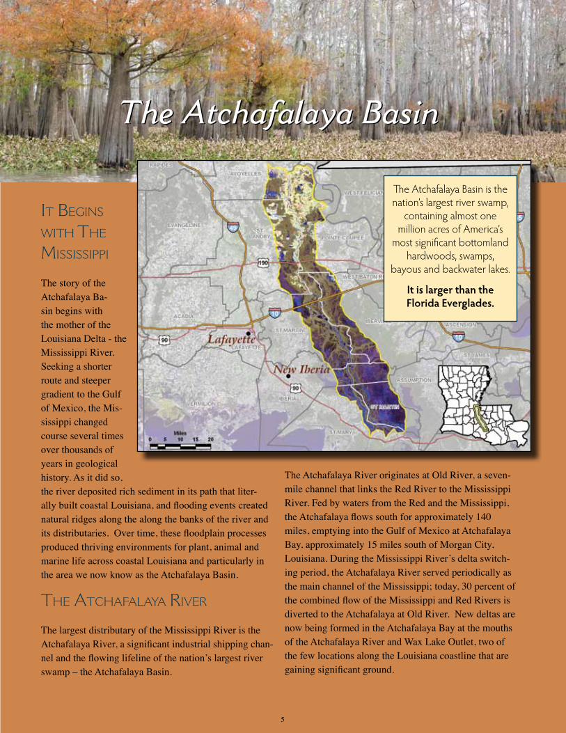
It BegIns wIth the MIssIssIppI
The story of the Atchafalaya Ba-sin begins with the mother of the Louisiana Delta - the Mississippi River. Seeking a shorter route and steeper gradient to the Gulf of Mexico, the Mis-sissippi changed course several times over thousands of years in geological history. As it did so, the river deposited rich sediment in its path that liter-ally built coastal Louisiana, and flooding events created natural ridges along the along the banks of the river and its distributaries. Over time, these floodplain processes produced thriving environments for plant, animal and marine life across coastal Louisiana and particularly in the area we now know as the Atchafalaya Basin.
the AtchAfAlAyA RIveR The largest distributary of the Mississippi River is the Atchafalaya River, a significant industrial shipping chan-nel and the flowing lifeline of the nation’s largest river swamp – the Atchafalaya Basin.
The Atchafalaya River originates at Old River, a seven-mile channel that links the Red River to the Mississippi River. Fed by waters from the Red and the Mississippi, the Atchafalaya flows south for approximately 140 miles, emptying into the Gulf of Mexico at Atchafalaya Bay, approximately 15 miles south of Morgan City, Louisiana. During the Mississippi River’s delta switch-ing period, the Atchafalaya River served periodically as the main channel of the Mississippi; today, 30 percent of the combined flow of the Mississippi and Red Rivers is diverted to the Atchafalaya at Old River. New deltas are now being formed in the Atchafalaya Bay at the mouths of the Atchafalaya River and Wax Lake Outlet, two of the few locations along the Louisiana coastline that are gaining significant ground.
The Atchafalaya Basin
The Atchafalaya Basin is the nation’s largest river swamp,
containing almost one million acres of America’s
most significant bottomland hardwoods, swamps,
bayous and backwater lakes.
It is larger than the Florida Everglades.
The Atchafalaya Basin

The Atchafalaya Basin stretches 100 miles from
North to South, from Simmesport in Avoyelles Parish to Morgan City in
St. Mary Parish.
Atchafalaya Basin Parishes:
• Assumption Parish• Avoyelles Parish
• Iberia Parish• Iberville Parish
• Pointe Coupee Parish• St. Landry Parish• St. Martin Parish• St. Mary Parish
6
AmericA’s LArgest river swAmp
The Atchafalaya Basin historically encompassed over 2 million acres, and was bounded by natural ridges to the east and west that formed as the Mississippi River changed its course as much as 4,500 years ago. Flood protection levees have substantially reduced the extent of Atchafalaya River’s historic floodplain; today, it en-compasses approximately 837,000 acres as it stretches approximately 100 miles from Simmesport southward to near Morgan City, LA.
With nearly a million acres of bottomland hardwoods, cypress swamps, bayous and backwater lakes, the Atchafalaya Basin is America’s largest river swamp. It boasts the largest contiguous tracts of fresh marsh in Louisiana, and is unique among basins in the state because it has a growing delta system with nearly stable wetlands. Major features in the basin include the Lower Atchafalaya River, Wax Lake Outlet, Atchafalaya Bay, and the Atchafalaya River and Bayous Chene, Boeuf, and Black navigation channel.
The Atchafalaya Basin is home to some of the country’s most productive habitats. Louisiana signature wildlife like alligators, roseate spoonbills, and crawfish; plant life like cypress trees and water hyacinths; and abundant fish and other aquatic life can be found here. It has long captured the interest of fishermen, hunters, photographers, campers and tourists who enjoy the sights and sounds of this natural wonderland.

7
A levee break during the Great Flood of 1927
protecting peopLe And property
The Atchafalaya River was not much more than a bayou in the early 1800’s when a 30-mile obstruction of logs and debris known as “the raft” restricted water flow into the river and prevented navigation between the Atchafalaya, the Red, and the Mississippi Rivers. By 1860, the majority of “the raft” was removed, dramatically increasing the river flow and allowing the Atchafalaya River to grow significantly wider and deeper. As the Atchafalaya began drawing more water from the Mississippi and the Red Rivers, floods became more severe. The wetland environments of the Atchafalaya Basin, like bayous, lakes, rivers and swamps, greatly expanded, but flooding also caused the decline of agriculture in the Basin. The worst flood on record along the lower Mississippi River system was the Great Flood of 1927, which put the entire Atchafalaya Basin, nearby communities and rural areas under water.
In reaction to this natural catastrophe, the federal government took steps to protect lives and property in the Basin, as well as to preserve the Atchafalaya River as a shipping channel. With the Flood Control Act of 1928, the federal govern-ment formally designated a portion of the Atchafalaya Basin as a “spillway,” to provide an outlet for diverted Mississippi River water in times of flooding. Extensive artificial levees were built to enclose the designated spillway area, distributary channels of the Atchafalaya River within the Basin were closed, the river was enlarged to handle increased capacity, and new diversion channels were created to provide for maximum discharge of floodwaters. In addition, a variety of dikes, dams, drainage canals, floodgates, pumping stations, locks, levees, and floodwalls were built to aid in navigation and flood control. The unintended consequence of these actions was an increase of sediment flowing into the Basin, turning many swampy areas into dry land. The physiography, hydrology, water quality, landscape and habitats of the Basin were changed significantly.
In 1963, the U.S. Army Corps of Engineers began operating the Old River Control Structure to regulate the flow of water into the Atchafalaya River from the Red and Mississippi Rivers. Ten years later, a catastrophic failure of the control structure during the height of a spring flood nearly resulted in the Atchafalaya River claiming over 70 percent of Missis-sippi River flow and threatening to change the course of the Mississippi River once again. Today, the Old River Control Structure directs 30 percent of the combined flow of the Mississippi and Red Rivers into the Atchafalaya River, and the Atchafalaya Basin Floodway remains an important outlet for Mississippi River floodwaters. It played a critical role, in fact, in the spring high water event of 2011.
Tourism in the Atchafalaya BasinVisitors to Atchafalaya Welcome Center
2004-2010: 716,871Visitors to Lake Fausse Pointe State Park
FY 2010-2011: 79,305
Data gathered from information provided by the Louisiana Department of Culture, Recreation and Tourism .

In April 2011, four major storm systems produced record rainfall amounts in the northern and central Mis-sissippi River watershed. This precipitation, combined with snowmelt from a record-breaking winter season, caused the river and many of its tributaries to swell by early May. A month after the Mississippi River crested in Min-nesota, record high water levels were measured down-stream in Louisiana, threatening to weaken or overtop earthen levees along the river between Baton Rouge and New Orleans. In an effort to protect levees, reduce stress on the Old River Control Structure, and ultimate-ly prevent major flooding in the highly populated urban areas and port complexes along the industrial corridor, the U.S. Army Corps of Engineers opened two gates at the Morganza Spillway on May 14, 2011. The spillway is a flood control structure along the Mississippi River near Mor-ganza, LA south of Old River, designed to divert water from the river during major flood events into the Atchafalaya Basin Floodway. By May 18, 2011, 17 gates were opened at Morganza, and the flow of water was often over 100,000 cubic feet per second (cfs) throughout the spillway’s opening. Closure of gates occurred over a more extended period of time. By June 6, only seven gates remained open, and the last gate was closed on July 7, with some residual flow from the Morganza forebay al-lowed to continue to drain. The Atchafalaya River crested at Simmesport, Louisiana between May 23 and May 24, at a river stage of 45 feet. Flood crest of 35 feet was measured at Melville, Louisiana, on May 24, and at Butte La Rose, Louisiana, a crest of just over 23 feet was recorded on May 27. It took three days for the flood crest to travel the 59.9 miles between Simmesport and Butte La Rose and another three days to crest 53 river miles downstream at Morgan City on May 30 at a stage of 10.3 feet. The Louisiana Department of Natural Resources and other state and federal agencies took action before the opening of the Morganza Spillway to reduce risk to public health and safety, and to protect the assets and resources of the Atchafalaya Basin wherever possible. These actions included: •Notificationtooilandgasoperators,pipelinesanddisposalfacilitiestotakemeasuresnecessarytosecure operations; •Notificationtostakeholderstosecureorremoveassets; •SecuringofWildlifeManagementAreasbytheLouisianaDepartmentofWildlifeandFisheries(LDWF); •DevelopmentbyLDNR,andimplementationbytheLouisianaOfficeofCoastalProtectionandRestoration (OCPR)andtheDepartmentofTransportationandDevelopment(LDOTD),ofaplantoprotectAtchafalaya Welcome Center and LDOTD communications assets in that area. In addition, the Department of Culture, Recreation and Tourism removed most assets from the Atchafalaya Welcome Center building as precautionary measure; and •CoordinationanddevelopmentofawaterqualitymonitoringplaninconjunctionwithmembersoftheAtchafalaya BasinProgram’sTechnicalAdvisoryGroup(TAG)
The Atchafalaya Basin Program (ABP) of the Louisiana Department of Natural Resources (LDNR) is compiling information on the impacts of the 2011 Flood to Atchafalaya Basin
resources and assets. LSU’s Louisiana Geological Survey (LGS) is on contract to the LDNR to assist in that effort. The ABP and LGS are working to quantify flood-related impacts to the Basin as well as public health and safety, and to compile water quality
monitoring information collected by many state and federal agencies during the flood, for inclusion in a detailed report to be issued at a later date.
A marina in the Henderson Lake area of the Atchafalaya Basin wsa inundated by floodwaters in May 2011.
of 2011 the flood of 2011
8

Satellite image (Landsat7) of the Atchafalaya Basin on May 18, 2011. Water is depicted in blue.
Seventeen gates were open at the Morganza Spillway by May 18, 2011.
Sources for the preceeding narrative include the Center for Louisiana Studies at the University of Louisiana-Lafayette, LA Department of Natural Resources, LA Coastal Wetlands Planning Protection and Restoration Program, LA Geological Suvey, U.S. Army Corps of Engineers, U.S. Geological Survey, and Inherit the Atchfalaya by Greg Guirard and C. Ray Brassieur.
the flood of 2011
9

10
1800 – 1838A 30-mile obstruction of logs and debris known as “the raft” in the upper reaches of the Atchafalaya River impedes the flow of water from the Mississippi and Red Rivers.
1839-1860Substantial portions of “the raft”are removed, greatly increasing the river flow and
allowing navigation between the Atchafalaya, Red and Mississippi Rivers. Commerce begins to develop in the Atchafalaya Basin, but flooding becomes severe and farmland in the Basin begins to fail. The
wetland environment of the Atchafalaya Basin greatly expands, signifying the birth of this important floodplain.
1870s-1930sLarge portions of the Atchafalaya swamp are clear-cut, resulting in the near extinction of old growth cypress forests.
1927The worst flood in recorded history in the Lower Mississippi River Valley occurred,
putting the entire Atchafalaya Basin and nearby communities and rural areas under water.
1928The Flood Control Act of 1928 transforms portions of the
Atchafalaya Basin into a “spillway.”
1929Construction of Atchafalaya Basin Floodway guide levees
begins.
1963Operation of the Old River Control Structure
begins to regulate water flow from the Mississippi and Red Rivers into the Atchafalaya River.
1970Louisiana Governor John McKeithen creates the first Atchafalaya
Basin Commission.
1972-1980Boat ramps are built, recreational facilities are planned, and the
State begins purchasing land for state parks.
1973The Interstate 10 elevated expressway over the Basin is completed.
“The Raft”
Old River Control Structure
Milestones in Atchafalaya Basin History
Sources for this historical information include the Center for Louisiana Studies at the Uni-versity of Louisiana-Lafayette, the Louisiana Department of Natural Resources, and U.S. Army Corps of Engineers.
Recreational Boat Ramps

1981The “Treen Agreement” (Governor Dave Treen) is negotiated between landowners
and environmental groups and is presented to Congress.
1985Congress enacts the Multipurpose Plan, authorizing the U.S. Army Corps of Engineers
to spend $250 million, subject to future appropriations, to preserve and restore the Basin ecosystem.
1998The Atchafalaya Basin Program is created within the Louisiana Department of Natural Resources.
1999The Louisiana Legislature unanimously approves the State Master Plan for the Atchafalaya Basin Program and $85 million, subject to future appropriations, over 15 years for access, easements, water management and recreation projects.
2004Atchafalaya Welcome Center in Butte LaRose opens.
2007 Congress directs an investigation and study of the maximum effective use of the water and sediment of the Mississippi and Atchafalaya Rivers for coastal restoration purposes consistent with flood control and navigation and an investigation and assessment of alterations in the operation of the Old River Control Structure.
2008The Louisiana Legislature adopts Act 606, authorizing the Secretary of the Department of Natural Resources, through the Atchafalaya Basin Program, to submit to the legislature each year an Annual Plan for the Basin that will include water management and access projects, such as boat launches, and other projects consistent with the mission statement of the Atchafalaya Basin Master Plan. Act 606 also creates the Atchafalaya Basin Con-servation Fund.
2009 The Louisiana Legislature approves $3,500,000 in state fund-ing for water quality/water management, access and habitat restoration projects identified in the FY 2010 Atchafalaya Basin Program Annual Plan, the first since adoption of Act 606.
2011 In May, the U.S. Army Corps of Engineers opens a total of 17 gates at the Morganza Spillway to relieve record high water levels in the Mississippi River. Diverted floodwaters inundated approximately 95,000 acres of agricultural land in the Atcha-falaya Basin and spared larger metropolitan areas downriver from catastrophic flooding.
Welcome Center
11

At Home in the Basin
12
For centuries, the resources and features of the Atchafalaya Basin
were adopted by settlers in the Basin and integrated into their unique
cultural heritages. Native Americans made their homes and built
communities among the bottomland hardwoods, and the Acadians fed
their families and started revered traditions by harvesting the natural
riches of the Atchafalaya Basin. Today, this national
treasure continues to be this nation’s most productive
river basin, and offers abundant opportunities to
residents, recreational visitors, and commercial
industries alike. The Atchfalaya Basin truly symbolizes
the adaptability and productivity of its past and
current inhabitants.
The Bayou Teche National Wildlife Refuge in Franklin,
Louisiana, is home to the largest concentration of Louisiana Black Bears
in south Louisiana.

The Atchafalaya Basin’s cultural history goes back at least 2,500 years, when Native Americans were living in the Basin along natural levees and along the bayous. Archeological research by Dr. Mark Rees of the University of Louisiana – Lafayette indicates that many mound sites and villages on natural levees and along bayous within the Basin date from A.D. 700-1700. Villagers harvested and hunted fish, shellfish, reptiles, birds, deer and small mammals that were plentiful in the area.
Tribes with a history in the Atchafalaya Basin include the Chitimacha, At-takapas, Opelousa, Houma, Coushatta and Alabama, Tunica-Biloxi and Avoyel, and Taensas. Native American association with the “great swamp” is evidenced by many place names in the modern Basin, including Atchafalaya (hacha falaia), bayou (bayuk), Catahoula (oka hullo), Chacahoula (chukka hullo), Plaquemine (piakimin), and Whiskey Bay (oski abeha).
In the early 1700’s, French settlers and slaves arrived in the Atchafalaya Basin to trade with the Native Americans, primarily in the fur trade. In 1755, how-
ever, one of the most culturally significant migrations into the Atchafalaya Basin occurred when refugees expelled from the Canadian province of Acadia found a home here. These immigrants quickly adapted to their new environment and developed skills that allowed them to survive in the challenging, yet fertile, swamp. As the years went by, they intermarried with other settlers of the area, including Hispanics, Old World and Canadian French, Anglo-Americans and Native Americans, result-ing in a people and culture referred to as “Cajun.” Many residents in the region surrounding the Basin, in fact, can trace their roots back to the Acadians, and the unique Cajun heritage is expressed in the food, music and traditions of the area. Other ethnic groups who immigrated to the area over the years include Creoles, African Americans, Colonial Spanish and Islenos, Italians and Asians, with each contributing their own cultural “seasonings,” so to speak, to the Atchafalaya Basin region’s cultural “gumbo.” The Atchafalaya Basin contains three distinct areas of landscape that provide some of the country’s most productive wild-life and fish habitats. These areas include the northern region composed of bottomland hardwood forest, the middle region composed of cypress-willow-tupelo swamps, and the lower region of freshwater and brackish marsh. The Atchafalaya Basin is five times more productive than any other river Basin in North America, and is probably the most productive swamp in the world.
Forty-five species of mammals inhabit the Basin, including bobcat, coyote, fox, armadillo, opossum and beaver. Small game animals like the fox squirrel, gray squirrel and swamp rabbit live here, as well as white-tailed deer, the principal big-game species. Raccoon, mink and nutria are so abundant in the swamps and marshes that Louisiana was ranked as the number one fur producer until the downturn of the industry about 15 years ago.
The wetlands of the Atchafalaya Basin provide excellent feeding and resting areas for migratory waterfowl, making the region an important wintering area for mallards and gadwalls. Over 250 species of birds can be found in the Basin, including the Bald Eagle, Peregrine Falcon and Bachman’s Warbler. Wood ducks, Great Blue Herons, and Great Egrets are common inhabitants of the shallow lakes and bayous.
13
“Atchafalaya” is
derived from the
Choctaw words
“hatcha” (river) and
“falaia” (long), meaning,
“long river .”

14
The Basin is a haven for an estimated nine federal- and state-recognized endangered/threatened wildlife species such as the Louisiana Black Bear, six endangered/threatened bird species, and 29 known rookeries. The Bayou Teche National Wild-life Refuge in Franklin, in fact, is home to the largest concentration of Louisiana Black Bears in South Louisiana. Over 40 reptilian species, including the American alligator and western cottonmouth, can be found in the Basin, along with 20 species of amphibians.
In the early years, the one element that seemed to tie all of the Basin settlers together was the bountiful resources of the hardwood forests, cypress swamps, bayous, and marshes, and the utilization of these resources for subsistence and commerce. Log-ging, agriculture and cattle farming were staples of life in the Basin. While much of the Basin today is unsuitable for farming due to its wetland status, major crops include sugarcane, rice, soybeans and cotton. And people from across South Louisiana and beyond continue to rely the Basin’s resources for their livelihood and recreation.
With over 100 species of fish, crawfish, shrimp and crabs, recreational and commercial fishing play significant roles in the economy of the Atchafalaya Basin. Commercial fishing began here in 1873, and by the early 1900’s, it had become a boom-ing enterprise with catfish as the most popular catch. Thousands of sport fishermen traverse the Basin’s waterways each year with the hopes of hooking yellow, striped or large-mouth bass, and white and black crappie.
Crawfish are typically associated with the cultural heritage of South Louisiana and the Basin, and while crawfish have been eaten in Louisiana since before the arrival of the Europeans, commercial crawfish harvesting in the Atchafalaya Basin did not take off until the 1960’s. It is now one of the most widely recognized industries in the Basin. From January to May 2010, over 8.6 million pounds of wild crawfish were harvested in the Atchafalaya Basin with a dock side value of more than $8.5 million, according to the Louisiana Department of Wildlife & Fisheries. Alligators, turtles and bullfrogs are also commer-cially and recreationally harvested along the Atchafalaya, and crabbing and trapping remain integral parts of the Basin culture and economy. In addition, recreational activities like boating, water skiing, bird-watching, hiking and camping also attract thousands of visitor to the Basin.
The landscape has changed since Native Americans first made their home on the grassy prairies and along the bayous of the Atchafalaya River Basin, but the Ba-sin’s natural beauty, ecological value and economic significance have endured for centuries. The current generation is chal-lenged with conservation and restoration of this unique Louisiana treasure so that many more generations of Louisianans can enjoy all that it has to offer.
Crabbing is an important part of the Basin seafood industry, and Basin crabs
are some of the largest and tastiest in the area.
Animals in the Basin include
the Louisiana Black Bear,
white-tailed deer, nutria,
bobcat, mink, fox, muskrat,
and beaver.

15
EconomicImpactofTravelinAtchafalayaBasinParishes(2010)
Parish Travel Expenditures Jobs Payroll State Sales Tax Receipts Local Sales Tax Receipts
Assumption $ 10,420,000 60 $ 1,115,000 $ 550,000 $ 240,000
Avoyelles $ 99,610,000 1,150 $ 23,830,000 $ 2,390,000 $ 1,600,000
Iberia $ 42,060,000 360 $ 6,510,000 $ 2,010,000 $ 750,000
Iberville $ 20,950,000 160 $ 3,170,000 $ 1,060,000 $ 880,000
Pointe Coupee $ 9,940,000 80 $ 1,310,000 $ 460,000 $ 250,000
St. Landry $ 92,060,000 630 $ 10,870,000 $ 5,050,000 $ 2,630,000
St. Martin $ 27,390,000 160 $ 3,420,000 $ 1,380,000 $ 1,560,000
St. Mary $ 147,860,000 1,650 $ 32,190,000 $ 4,280,000 $ 2,490,000
Source: Louisiana Department of Culture, Recreation, and Tourism
From January to July 2011, landings of wild crawfish in the
Atchafalaya Basin equaled 7,025,432 pounds with a dockside
value of $7,066,629, according to an analysis of trip ticket
data by the LA Dept. of Wildlife and Fisheries.
The number of hunting and fishing licenses sold by vendors in and/or to residents of
Atchafalaya Basin Parishes in 2010*:• Resident hunting licenses - 37,923
• Non-resident hunting licenses - 776• Resident recreational fishing licenses - 66,510
• Non-resident recreational fishing licenses - 5,128• Commercial fishing & hunting licenses - 12,241
*Data gathered from information provided by the Louisiana Department of Wildlife and Fisheries .

The ATchAfAlAyA BAsin ProgrAm
Louisianans have long recognized the ecological value of the Atchafalaya Basin and, as early as the 1960’s, began efforts to attract federal support for its restoration. The federal govern-ment’s interest in the Atchafalaya Basin Floodway, however, was primarily focused on its value as a flood control and navi-gation asset. With the adoption of the Water Resources Devel-opment Act and subsequent legislation in 1985 and 1986, the U.S. Congress established as public policy the need for the nation to invest in public access, acquisition of environmental easements, water management projects, and recreational op-portunities in the Atchafalaya Basin.
In 1996, the Louisiana Department of Natural Resources (LDNR) was named lead state agency in the development of a plan to protect and develop the Atchafalaya Basin as directed by Congress, in conjunction with the U.S. Army Corps of Engineers (USACE). The Louisiana Legislature created the Atchafalaya Basin Program and its advisory Research and Promotion Board in 1998. The State Master Plan for the Atchafalaya Basin was developed that year and approved unanimously by the Louisiana Legislature in 1999. Act 3 and Act 920 of the 1999 Louisiana Legislature empowered the Atchafalaya Basin Program to act on behalf of the State to implement and man-age a comprehensive State Master Plan for the Atchafalaya Basin. To that end, the program staff regularly meets with USACE representatives regarding activities and projects in the Basin.
Over the years, the Atchafalaya Basin Program has also entered into agreements with the USACE, Basin parishes, area towns and cities, the Atchafalaya Basin Levee District, and several state agencies involved in the Basin Program to advance conservation, restoration, enhancement, and recreation projects. These state agencies include Agriculture and Forestry; Culture, Recreation and Tourism; Environmental Quality; Health and Hospitals; Natural Resources; Transportation and Development; Wildlife and Fisheries; and the State Land Office. The Atchafalaya Basin Program office is located in the LaSalle Building on N. Third Street in Baton Rouge. Atchafalaya Basin
Program Staff:Stephen Chustz, Acting Director
David Fruge, Coastal Resources Scientist/Project Specialist
Dana Naquin, Administrative Specialist
Contact Us:
P .O . Box 94396, Baton Rouge, LA 70804-9396
Phone: (225) 342-6437 · Fax: (225) 342-6887
E-mail: atchafalaya@la .gov
16
The Atchafalaya Basin Program was primarily focused on the recreational component of the Atchafalaya Basin Master Plan from its inception through 2005, when the focus transitioned to water resource management and enhanced water access. Recognizing the need to codify this shift in public policy, the LDNR took a lead role in working with the legislature to draft and enact Act 606 of the 2008 Regular Legislative Session. This Annual Plan is a direct result of that effort.
The Atchafalaya Basin provides habitat for over
300 species of birds, including the Bald Eagle,
Great Blue Heron and the Peregrine Falcon .

17
currenT chAllenges in The BAsinThe Atchafalaya Basin is the nation’s largest river swamp and one of America’s most productive ecological regions. However, like other water resources, this system faces many stresses and challenges, including several cited in a 2001 U.S. Geological Survey fact sheet, “The Atchafalaya Basin – River of Trees.” • Ever-Changing Hydrology – Natural changes and human-induced modifications have resulted in the alteration of the ecology of this resource and will continue to do so. • Sedimentation – Since 1932, there has been a net accretion of nearly 2.5 billion cubic meters of sediment in the Basin floodway, converting much open water and cypress swamps to bottomland forest. • Hypoxic Conditions – Spoil banks, oil field canals and natural levees inhibit the historical sheeting pattern of water flow, causing hypoxic conditions (poor water quality) within nearly all of the large, interior swamps. • Invasive Exotic Plant Species – Massive growth of hydrilla, salvinia, giant salvinia and water hyacinth restricts access to many areas in the Basin and exacerbates hypoxic conditions in the swamps. • Land Use/Resource Issues – Diverse and sometimes conflicting activities within the Basin occur with regard to flood control, commercial fisheries, navigational, petrochemical, silviculture, recreational, environmental, and cultural interests. • Subsidence and Land Loss – Areas within the Basin but outside the floodway lack sufficient sediment, resulting in subsidence and land-loss problems.
The Atchafalaya Basin Annual Plan process is critical to a sustainable future of the Atchafalaya Basin . The focus on science-based water management ensures that projects selected
for implementation will be beneficial to the ecological and environmental health of the Basin . Successful project implementation will lead to improved water quality, enhanced habitat, a more vibrant ecological community . Collaboration between Basin stakeholders and State and Federal agencies allows for coordination of limited resources and restoration efforts to maximize results
and provide a healthy ecosystem in the Atchafalaya Basin for generations to come .

18
fY 2013 AnnuAl PlAn ProceSS
Act 606 of the 2008 Regular Session of the Louisiana Legislature specifically mandates that the Secretary of the Louisi-ana Department of Natural Resources (LDNR) present an Annual Basin Plan to the Louisiana Legislature at least thirty days before the start of each regular legislative session for the Legislature’s review and approval.
The plan identifies all projects or stages of projects in the Atchafalaya Basin Floodway System and surrounding areas that will be proposed for funding in that fiscal year. The Plan recognizes three distinct project categories: water quality/water management, access, and other projects consistent with the mission of the Atchafalaya Basin Master Plan. Water management projects are intended to accelerate restoration of the Atchafalaya Basin by facilitating improvement in water quality, interior circulation, water access, or improving the general ecosystem through sediment reduction, removal or redistribution. Public access projects are focused on enhancing public use of the recreational opportunities, such as the construction or renovation of a boat launch or a roadway that provides access to areas of the Atchafalaya Basin, acquisition of a maximum of 1,500 acres, or other projects consistent with the mission of the Atchafalaya Basin Master Plan.
sTrucTure
In order to develop the Annual Plan, Act 606 activates a 14-member Atchafalaya Basin Program Research and Promotion Board and creates a nine-member Technical Advisory Group (TAG), chaired by the Louisiana Department of Wildlife and Fisheries. LDNR is the lead agency for the development of the Annual Plan. The Research and Promotion Board oversees the Atchafalaya Basin Program, approving projects in the Annual Plan that enhance, protect and preserve this unique treasure of Louisiana. This Board is charged with adopting criteria to be used in determining the eligibility of projects listed in the Annual Plan, identifying access projects for the plan, conducting public hearings prior to adoption of the plan, publishing the plan and submitting the final plan to the LDNR Secretary.
The TAG is composed of resource experts responsible for reviewing, evaluating and approving all water management and water quality projects for the Basin Program’s Annual Plan. The makeup of the TAG is intended to ensure that the best science is used in focusing on restoration and preservation of the Basin ecosystem. TAG members are confirmed by the Atchafalaya Basin Oversight Committee of the Louisiana Legislature.
Photos from Basin Fans“Basin Pics” is the Atchafalaya Basin Program’s online gallery featuring photos submitted by residents and tourists “Livin’ and Playin’ in the Basin .” We are pleased to include some of these amazing photos of the Basin’s beauty and wildlife won-der in this FY 2013 Annual Plan . Thanks to all our contribut-ing photographers and keep the pics coming!
www.Basin.la.gov

DeveloPment
The FY 2013 Atchafalaya Basin Annual Plan process began in July 2011 as the Department of Natural Resources Atchafalaya Basin Program invited the public to suggest water quality/water management projects to be considered for inclusion in the Plan. Public involvement was key in plan development.
Following is a list of public meetings conducted as part of the FY 2013 Annual Plan process:
Research & Promotion Board MeetingsJuly 21, 2011November 3, 2011November 30, 2011January, 2012
Technical Advisory Group MeetingsAugust 30, 2011September 14, 2011October 4, 2011October 20, 2011
Louisiana Coastal Protection and Restoration Authority MeetingsDecember, 2011January, 2012
Public MeetingsAugust 9, 2011 in Morgan City, LAAugust 10, 2011 in Plaquemine, LAAugust 17, 2011 in St. Martinville, LANovember 14, 2011 in Morgan City, LA November 16, 2011 in Plaquemine, LA November 17, 2011 in St. Martinville, LA
The Draft FY 2013 Annual Basin Plan will be submitted to the Louisiana Coastal Protection and Restoration Authority (CPRA) for that panel’s review and approval as consistent with the Master Plan for Coastal Protection and Restoration. The FY 2013 Annual Plan will then be submitted to the Research & Promotion Board for final ap-proval, and published and submitted to the Louisiana Legislature for consideration, in compliance with Act 606 of the 2008 Regular Session of the Louisiana Legislature.
19
One hundred species of fish and aquatic life can be found in
the Atchafalaya Basin, and it is five times more productive
than any other river basin in North America.

Act 606 of the 2008 Regular Session of the Louisiana Legislature creates the Atchafalaya Basin Conservation Fund to finance projects listed in the Atchafalaya Basin Program Annual Plan. Of the monies allocated to the Fund in any one fiscal year, Act 606 requires that 75 percent shall be used for water management, water quality or access projects, and 25 percent shall be used to complete ongoing projects and/or to fund projects that are in accordance with the Mission Statement of the State Atchafalaya Basin Master Plan that was unanimously approved by the Louisiana Legislature in 1999 (Act 920).
Act 541 of the 2009 Regular Session of the Louisiana Legislature provided for a constitutional amendment that set a funding source for the Atchafalaya Basin Conservation Fund to be put on a statewide ballot for voter approval. The amendment was approved on November 2, 2010, providing a dedicated source of funding for the Fund and predictable funding levels for future plans when certain criteria are met. To date, these criteria have not been met. Actual implementation of projects is dependent on the traditional state and federal appropriations processes.
In order to provide transparency in government, Act 606 of the 2008 Regular Session requires multiple public meetings for the development and review of the Annual Basin Plan and subsequent approval by the Atchafalaya Basin Research and Promotion Board and the Coastal Protection and Restoration Authority, all to be completed at least thirty (30) days prior to commence-ment of the regular legislative session. Therefore, it is required that the Annual Plan be drafted prior to the development of the appropriations bill that often funds the plan. While it is certainly appropriate to have a public vetting prior to submittal of the Annual Basin Plan to the Louisiana Legislature, one of the challenges of the process is determining the level of funding that will be provided. Until such time as appropriations are finalized, the level of funding for projects and the number of projects in the Plan that may be funded is uncertain.
Water quality/water management projects proposed in the FY 2013 Annual Basin Plan are listed in current order of priority as established by the Atchafalaya Basin Research and Promotion Board. This list includes new projects, as well as water quality/water management projects that were approved in the FY 2011 and FY 2012 Annual Plans but not totally funded for construc-tion. Projects may be constructed based upon the level of funding provided in FY 2013 and prioritization established by the Research and Promotion Board. The Board will consider funding provided to the Atchafalaya Basin Conservation fund, with 75 percent of the funding being used for water management, water quality or access projects and the remaining 25 percent used to complete ongoing projects and for projects that are in accordance with the mission statement of the State Atchafalaya Basin Master Plan as required by Act 606.
Adaptive management is a key component of ecosystem restoration in the Atchafalaya Basin and, as such, funding flexibility and project implementation flexibility must exist to ensure that projects in the Annual Plan are implemented in a way that will maximize our resources. The funding appropriated will be distributed among approved projects in a way that maximizes the benefits to the Atchafalaya Basin and achieves the greatest cumulative benefit as approved by the Research and Promotion Board. It is recognized that some projects may encounter unforeseen circumstances that will hinder project implementation, such as access, land rights, availability of federal matching funds, and costs that were not anticipated. Those projects that are listed and are subject to these circumstances will be deferred until such time as those issues are resolved or additional funding is obtained to address the circumstances.
If this occurs and a project is deferred, those funds thereby released may be used for funding alternative projects, or parts of projects, included in the Annual Plan that would have not otherwise been funded due to limited appropriations. Once funding levels for the FY 2013 Annual Plan are determined and project costs detailed, projects that are proposed for funding will be brought before the Atchafalaya Basin Research and Promotion Board with proposed budgets for approval. Any subsequent
ProjecT funding And PrioriTizATion
20

21
Atchafalaya Basin WMU’s
significant changes to the approved budgets or project scope will also be brought before the Research and Promotion Board for approval.
Some projects that have been deferred as part of this Annual Plan process may later be identified for implementation. Should funding become available, previously deferred projects may be implemented provided that they are approved by the Technical Advisory Group, Atchafalaya Basin Research and Promotion Board, and the Joint Legislative Committee on Natural Resources; are consistent with the language of Act 606 of the 2008 Regular Session of the Louisiana Legislature; and meet one or more of the following qualifications: 1. Part of the Atchafalaya Basin Master Plan; 2. Part of the Atchafalaya Basin Floodway System, Louisiana Project; 3. Water management or water quality project that meets the criteria developed by the board for inclusion in the Annual Plan and has been approved through the procedures adopted by the board for inclusion of a project in the Annual Plan, including public hearings; 4. Consistent with the mission statement contained in the Atchafalaya Basin Master Plan; 5. A project to be completed which was previously approved by the Research and Promotion Board.

fy 2013 ProjecT lisT
Water Quality / Water ManageMent Projects
This category includes activities such as sediment removal, redistribution, construction of cuts and gaps; data collection, evaluation and monitoring; and related planning, engineering and design within the Atchafalaya Basin’s 13 Water Management Units. In addition to newly proposed projects listed, Water Quality/Water Management Projects that were approved in the FY 2011 and FY 2012 Atchafalaya Basin Annual Plans, but not funded or only partially funded for construction may be funded in the FY 2013 Annual Plan based on the prioritization given to these projects by the Atcha-falaya Research and Promotion Board.
NEW WATER QUALITY/ WATER MANAGEMENT PROJECTS PROPOSEDINFY2013ANNUALPLAN
PROJECT NAME PROJECT NUMBER STATUS Bristow Bayou 201105 Proposed for Funding North of I-10
Bathymetry Data in 201108 Proposed for Funding American Pass
APPROVEDFY2011ANDFY2012WATERQUALITY/WATERMANAGEMENTPROJECTSPROPOSEDFORCONSTRUCTIONFUNDINGINFY2013ANNUALPLAN
PROJECT NAME PROJECT NUMBER STATUS East Grand Lake Project 201006 Partially Funded in FY 2012 Plan, additional funding needed
Big Bayou Pigeon 200918 Proposed for Funding
Little Bayou Pigeon 200921 Proposed for Funding
Open Brown Bayou to the 200931 Proposed for Funding I-10 Canal
22
The projects listed above are referenced by their project numbers on the map displayed to the right:
>>>

23
Water Quality/Water Management Projects Proposed in FY 2013 Annual Plan

access Projects
This category includes the construction or renovation of boat launches that provide public access to areas in and adjacent to the Atchafalaya Basin. Access projects listed below were approved in the FY 2012 Annual Plan, but no funding was allocated. They are being proposed for funding in the FY2013 Annual Plan.
PROJECT NAME STATUS Wilson’s Landing Proposed for Funding
Sandy Cove Landing Proposed for Funding
Ramah Landing Proposed for Funding
Catahoula Landing Proposed for Funding
24
Atchafalaya Online The Atchafalaya Basin Program website brings the Basin to your fingertips . Vist www.Basin.Louisiana.gov for water levels, Basin facts, photos and more! It’s all here:• Basin Pics - View our gallery and submit your shots• Real-time water levels of popular fishing spots• Upcoming Basin activities• List of Basin sportsmen groups• FY 2010- 2013 Atchafalaya Basin Annual Plans• Information on purchasing full-color Basin maps• Upcoming Atchafalaya Basin Program meetings• Facts about the Basin
www .Basin .Louisiana .govWhen you can’t visit the Basin in person, visit it online at www.Basin.Louisiana.gov

The Atchafalaya Basin Program has a history of promoting public use of the Basin and, as such, continues to work to implement recreation projects that are part of the State Master Plan, part of the legislation, ongoing projects previously approved by the Research and Promotion Board, and/or consistent with the Mission Statement of the State Master Plan.
Projects consistent with the above criteria, including additional phases of some ongoing proj-ects, are proposed for funding in FY 2013. These projects, in alphabetical order, include: Up-dating of the Atchafalaya Basin Master Plan, Belle River Park, Biking/Paddling/Hiking Trails, Camp Atchafalaya, Habitat Restoration, Lake End Park Cabins, Morgan City Interpretive Center, primitive campgrounds, Stephensville Park, and Veterans Park.
Based upon the level of funding provided, projects that are proposed for funding will be brought before the Atchafalaya Basin Program’s Research and Promotion Board for approval.
other Projects and initiatives consistent With the
Mission stateMent of the state Master Plan
25
Hunters and Hounds gather in the early morning.

26
New Water Quality/Water Management Projects Proposed in FY 2013 Annual PlanProject DescriPtions
Bristow Bayou North of I-10 (201105 )According to local residents, water in the area between the LDWF South Farm section of the Sherburne Wild-life Management Area and the I-10 Canal has begun to pool and stagnate, due to inadequate culverts placed in Bristow Bayou. The area previously would flood and drain during high water periods. The project nominator suggested that the existing culverts at Bristow Bayou on the north side of the I-10 Canal be replaced with larger culverts or a bridge to accommodate adequate water movement.
The Technical Advisory Group recognizes the restricted water flow into and out of the area. TAG recommends that improvements be made to remove restrictions and improve water flow in an effort to improve water quality and drain impounded forested habitats currently in danger of being degrad-ed due to ponding in the area.
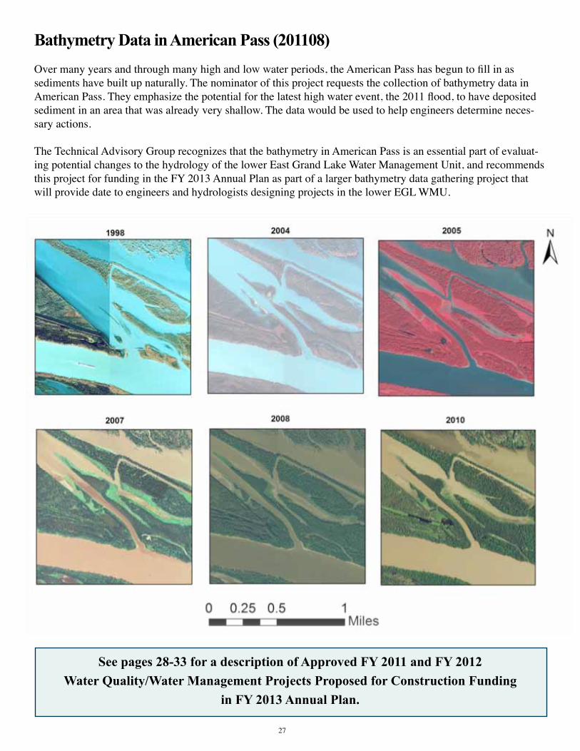
Bathymetry Data in American Pass (201108)Over many years and through many high and low water periods, the American Pass has begun to fill in as sediments have built up naturally. The nominator of this project requests the collection of bathymetry data in American Pass. They emphasize the potential for the latest high water event, the 2011 flood, to have deposited sediment in an area that was already very shallow. The data would be used to help engineers determine neces-sary actions.
The Technical Advisory Group recognizes that the bathymetry in American Pass is an essential part of evaluat-ing potential changes to the hydrology of the lower East Grand Lake Water Management Unit, and recommends this project for funding in the FY 2013 Annual Plan as part of a larger bathymetry data gathering project that will provide date to engineers and hydrologists designing projects in the lower EGL WMU.
See pages 28-33 for a description of Approved FY 2011 and FY 2012Water Quality/Water Management Projects Proposed for Construction Funding
in FY 2013 Annual Plan.
27

ongoing WATer QuAliTy / WATer mAnAgemenT ProjecTs
aPProved fy 2012 annual Plan Water Quality/Water ManageMent Projects
East Grand Lake Project (201006)Approved for Design/Engineering and Construction Funding
The ABP’s FY2010 Annual Plan project titled “Development of a Complete and Specific Plan to Address Water Quality and Sedimentation in East Grand Lake/Flat Lake/Upper Belle River Management Units Through Modi-fication of Water & Sediment Inputs” or “East Grand Lake (EGL) Project area” has been utilized to develop projects that are proposed in these water management units for the FY2012 Annual Basin Plan. The funding of these projects in the Upper Region is the first step in developing the plan to realign water flow patterns and stra-tegically redirect sediment in the EGL Project area. Additional Annual Plan cycles will be necessary to identify and fund projects for the Western and Lower Regions as described in the Summary Report (located at: http://dnr.louisiana.gov/sec/atchafalaya/East-Grand-Lake-Summary-Report.pdf).
The Upper Region was chosen as the initial point of developing the overall strategy for the EGL Project area because there is a reasonable confidence in the projected benefits for realignment of flow and sediment. Ad-ditionally, since north-south flow patterns that disperse water and sediment more evenly throughout the Project area are desired, a north to south planning effort seems to be the most logical approach. Also, the Western and Lower Regions present greater uncertainty in realignment and will therefore require additional information before projects can be designed.
The Upper Region takes in the area south of Bayou Sorrel to Old River and east of Grand Lake to the GIWW and covers an estimated 72,143 acres. While elevation or “LIDAR” data suggests the Upper Region has fewer restrictions to flow than other areas of the EGL Project area which allow for good water to enter and circulate throughout a large portion of the Region, the highly channelized delivery of water through the School Board Ca-nal (Unnamed Canal), Indigo Bayou, Salt Mine Bayou, Williams Canal, Bayou Pigeon, and the Coon Trap has developed a sediment delivery network that carries sediment deep into the Project area which in turn promotes further restriction of flow and isolation of small areas. Modifying this network of channelized water inputs was the initial target for realignment.
The strategy to improve water quality is the realignment of water input through the northern part of the Upper Region with construction of bank shavings and reestablishment of existing fresh water inputs along Bayou Sor-rel, School Board Canal (Unnamed Canal), Indigo Bayou, and Cannon Bayou. To complement additional input entering in the north, gaps positioned further south in the banks of Salt Mine Bayou, the Florida Canal, and the Williams Canal are designed to promote sheet-flow patterns southward through the Region.There are a total of 171 features that were identified by the TAG subcommittee and found to be the best pos-sible solutions for achieving the desired goals of realigning sediment and water in the Upper Region of the EGL Project area. Elements were excluded that were found to be less than optimal for achieving the desired goals and may be incorporated into future plans should the need arise.
28

The 171 features include the following and are depicted in the map on the next page: • 37 – Clean outs to remove woody vegetation and debris from aproxmently100 ft. wide x 100 ft. long in existing gaps where little if any sediment will be removed.
• 14 – Bank shavings typically to 8 ft. bottom elevation and 30 ft. bottom width and an average estimated length of 1,967 ft.
• 49 – Re-establishment of existing water inputs, typically to 6.5 ft. bottom elevation and 30 ft. bottom width and an average estimated length of 810 ft.
• 70 – Gap developments and reduction of banks typically to 6.5 ft. elevation and 100 ft. wide and an average estimated length of 302 ft.
• Although technically located in the Western Region of the EGL Project area, when water levels are above 8 - 8.5 ft. at the Butte La Rose water gauge, the Coon Trap input is an important source of fresh water to both the Upper and Western Regions. Dependent upon the need for additional water in this area, an option to remove a maximum of 3 ft. of material from the Coon Trap Weir to improve input at lower River stages will also be evaluated and constructed if needed.
The success of the entire EGL Upper Region and EGL Project area hinges on the implementation of a suite of construction projects that complement each other in order to keep the water moving from north to south throughout the Region. Benefits that will be realized are therefore dependent on the amount of funding that is provided to construct the features that are proposed. Locations may have to be modified based upon landowner and access issues and adaptive management strategies.
Status Report: Project was partially funded for engineering and construction as part of the FY 2012 Annual Basin Plan. Engineering and design will soon begin.
Sediment in the Upper Region of East Grand Lake restricts flow and contributes to poor water
quality. Proposed modifications will improve water flow patterns and water quality conditions.
29

30
East Grand Lake Project (201006) continued

31
Improve Water Quality in the Upper Grand River Flats (201001) Approved for Design/Engineering and Construction Funding
Over the years, local users have witnessed water quality, crawfish harvest, and fish abundance diminish as freshwater input into the Upper Grand River Flats (UGRF) has decreased due to sediment build up and de-creased fresh water input. Based on data and local statements, water flow patterns are unique in the project area throughout the year. During the higher water periods of the crawfish season, water flows from the Atchafalaya Basin Main Channel eastward through the Upper Grand River and then north through the Work Canal and north into the UGRF at the southeast corner.
Utilizing this unique hydrology, it is expected that by constructing and improving fresh water inputs on the east side of the Work Canal and improving the current drain on the southeast corner, incremental improvements in water quality and ecological conditions will occur. In total, there are four (4) project features in the UGRF area. The three (3) features proposed to increase fresh water input from the Work Canal, which borders the area to the west, are bank shavings to an approximate 8 ft. bottom elevation and 30 ft. bottom width. The last feature is to reduce the elevation by 1 and 2 feet of sediment in the southeast corner of the project to promote draining into the Upper Grand River. See figure below for location of project features. Locations may have to be modi-fied based upon landowner and access issues and adaptive management strategies.
Status Report: Project was funded for engineering and construction as part of the FY 2012 Annual Basin Plan. Engineering and design will soon begin.
aPProved fy 2011 annual Plan Water Quality/Water ManageMent Projects
Cocodrie Swamp Project (200915 and 200916)Approved for Design/Engineering and Construction Funding
Bayou LaRose, in the Cocodrie Swamp Water Management Unit in St. Martin Parish, was once a very signifi-cant, commercially navigable waterway and the main source of freshwater for the swamp area. The cutting of oil and gas canals and USACE channel training has caused Bayou LaRose to silt up in many places and has resulted in portions of the bayou and the surrounding swamp being cut off from fresh water and devoid of plant and marine life. The goal of the project is to open natural waterways that are currently blocked to improve freshwater flow and navigation and to promote forest health.
The work would include directing water through two existing deltas south of Bayou Garofier and possibly through Bayou LaRose by removing sediment from the main channels and near the mouths of the bayous and removing impediments to water flow throughout the length of the canals. Other work involves removing the plug from Old Bayou LaRose at the Panatec Canal, opening old Bayou Cocodrie to allow water to enter the swamp to the east, and overall drainage improvements in the project area.
Status Report: Funding for design, engineering and construction was approved by the Research and Promo-tion Board, and approved by the Bond Commission on October 21, 2010. The Atchafalaya Basin Program is
Cocodrie Swamp
OutflowcanalintotheUpperGrandRiveris restricted by sediment and vegetation.
Cocodrie Swamp

32
continuing coordination with stakeholders to refine project plans, consistent with the approved budget. Engi-neering services contracts are now in place for project design and preparing plans and specifications. Profes-sional land services contracts have also been approved to assist in identifying and obtaining approval needed from involved affected landowners in the project area.
Open Location Canal into Swamp North of Bayou Sorrel (200941)Approved for Design/Engineering and Construction Funding
Bayou Sorrel is located in the Pigeon Bayou Water Management Unit in Iberville Parish. Poor water quality has resulted in poor fishing conditions and fish kills, and the original lakes in the Sorrel Oil Field area and north of that area are nearly gone. What remains is cut off from freshwater flow.
This project would include opening Location Canal south of the pipeline along the Upper Grand River exten-sion to increase freshwater flow into the area north of Bayou Sorrel Oil Field. An opening from Upper Grand River just south of the Location Canal that flows into two ponding areas would function as vegetated sediment filtration zones.
Status Report: Funding for design, engineering and construction was approved by the Research and Promo-tion Board, and approved by the Bond Commission on October 21, 2010. Budget amendment has been ap-proved, and action is being taken to identify landowners and secure agreements, and to contract engineering services for project plans and specifications.
Open Brown Bayou to the I-10 Canal (200931)Approved for Design/Engineering Funding. No Funding Approved for Construction.
When the canal between the I-10 spans and the Work Canal in Iberville Parish was dug, Brown Bayou and several other natural waterways were cut off, eliminating access and a route for freshwater flow to interior lakes and swamps. The Technical Advisory Group recommends clearing Brown Bayou to the I-10 Canal. This action will re-establish flow south into Brown Bayou. The work area is the Bayou Des Glaises Water Manage-ment Unit.
Status Report: Design/engineering funding was approved by the Research and Promotion Board, and ap-proved by the Bond Commission October 21, 2010. Budget amendment has been approved. Land rights must be secured and regulatory issues must be resolved prior to this project moving forward.
Bayou Fourche (200925)Approved for Design/Engineering and Construction Funding
There is no longer any water flow at any river stage in Bayou Fourche below Bayou Postillion, in the Flat Lake/East Grande Lake Water Man-agement Unit in Iberville Parish. This project would involve clearing or dredging the existing canal to promote flow into the area from the Gulf Intracoastal Waterway.
Brown Bayou
Bayou Fourche

Status Report: Funding for design, engineering and construction was approved by the Research and Promo-tion Board, and approved by the Bond Commission on October 21, 2010. Budget amendment has been ap-proved, and action is being taken to identify landowners and secure agreements, and to contract engineering services for project plans and specifications.
Big Bayou Pigeon (200918)Approved for Design/Engineering Funding. No Funding Approved for Construction.
Sediment has built up along nearly seven miles of the main channel of Big Bayou Pigeon in Iberia Parish, reducing water flow and impairing navigation. The project area is in the Upper Belle River Water Manage-ment Unit. The Technical Advisory Group recommended dredging Bayou Pigeon to no more than the width of the channel at low or intermediate river stage and only as far downstream as needed to provide for small boat passage at low water (low water level to be determined). The bottom contour of the channel shall mimic natural channel side-slope, and the channel depth shall provide three feet of access depth at low river stage. Sediment reduction will be achieved with a mid channel dug deeper than the rest of the bayou within the first half-mile of the dredging operation, and the sediment trap should have a five-year life expectancy. Spoil disposal options shall be in a manner that is beneficial to the surrounding forest and does not increase the elevation of existing flow barriers. Project details will be further developed during the engineering phase with review by the TAG.
Status Report: Design/engineering funding was approved by the Research and Promotion Board, and ap-proved by the Bond Commission on October 21, 2010. Budget amendment has been approved, and action is being taken to identify landowners and secure agreements. Major landowner in the project area has indicated that they are not interested in participating in this project. Other landowners in the project area are being identi-fied to determine options and cost of handling material that is dredged. Contracting for engineering services to produce project plans and specifications will begin once land rights issues are resolved.
Little Bayou Pigeon (200921)Approved for Design/Engineering Funding. No Funding Approved for Construction.
Silt has built up in Little Bayou Pigeon from the crossover to Grand Lake in the Upper Belle River Water Man-agement Unit in Iberia and St. Martin Parishes. This project would involve clearing debris and vegetation from Little Bayou Pigeon east from East Grand Lake and dredging, if necessary, to provide access to the lake.
Status Report: Design/engineering funding was approved by the Research and Promotion Board, and ap-proved by the Bond Commission on October 21, 2010. Budget amendment has been approved, and action is being taken to identify landowners and secure agreements. Major landowner in the project area has indicated that they are not interested in participating in this project. Other landowners in the project area are being identi-fied to determine options and cost of handling material that is dredged. Contracting for engineering services to produce project plans and specifications will begin once land rights issues are resolved.
Little Bayou Pigeon
33

aPProved and funded fy 2010 annual Plan Water Quality/Water ManageMent Projects
Atchafalaya Basin Natural Resource Inventory & Assessment System The Atchafalaya Basin is a resource that must be managed on a system-wide basis to ensure this invaluable national resource is protected and restored. It is recognized that we must develop better tools for managing the Basin and that data evaluation is necessary to ensure sound decision-making. The natural resource inventory and assessment system that was approved and funded in the FY 2010 Annual Plan will serve as the primary tool for decision making in the Basin. The system will provide a means for scientists to access relevant project data for the Basin and to request and fund data acquisition, monitoring, and data analysis to be used in project plan-ning. This will be critical in providing information necessary for the development and approval of specific proj-ects to be included for construction in future Annual Plans, projects that meet the needs of Louisiana’s citizens and protect our natural resources.
This system will also assist in evaluating how the Atchafalaya Basin may interconnect with Coastal Protection and Restoration Authority projects by providing sediment and fresh water to nurture emerging marsh habitat without having an adverse impact on Basin resources. According to the Louisiana Comprehensive Master Plan for a Sustainable Coast, “The Atchafalaya River delta is the only region of coastal Louisiana that is building land naturally, and the master plan seeks to take maximum advantage of this resource.”
Status Report: Web-based version of the NRIAS is now available online. Enhancements to the system con-tinue to be made.
Dog Leg Canal Sediment Trap Maintenance Dredging The Dog Leg Canal is located within Attakapas Island Wildlife Manage-ment Area in St. Mary Parish, approximately two miles north of Millet (Myette) Point on the east bank of the Atchafalaya River. It was previously opened to the Atchafalaya River, at the request of the commercial fishing industry, to allow freshwater to flow into this area of the Basin and improve water quality, primarily dissolved oxygen levels. A natural sediment trap existed near the Dog Leg cut that is believed to be in part responsible for the success of the project. That sediment trap is now almost completely filled and has caused transportation of sediment further into the canal. This sedimentation of the canal has decreased the canal’s ability to transport freshwater into the adjoining swamp. Maintenance dredging of the Dog Leg Canal sediment trap will restore the functionality of the sediment trap and prolong the transport of freshwater from the Atchafalaya River to the swamp.
Status Report: Corps permit has been issued and engineer completed plans and specifications which have been reviewed by Facility Planning and Control, comments from FP&C are now being addressed by the Engi-neer. Construction schedule will be dependent on water levels dropping to a level that will allow project to be constructed cost effectively.
34

DevelopmentofaCompleteandSpecificPlantoAddressWaterQualityand Sedimentation in East Grand Lake/Flat Lake/Upper Belle River Man-agementUnitsThroughModificationofWater&SedimentInputsThe East Grand Lake/Flat Lake/Upper Belle River WMU’s have degraded due to water movement being blocked by sediment and spoil deposition, thereby causing low oxygen levels and loss of habitat. This project will analyze water flow and sediment deposition throughout the study area, including analysis of five inputs into the system: American Pass, Bayou Sorrel, Blue Point Chute, Coon Trap Weir, Dog Leg Canal and Indigo Bayou. A plan is being developed to realign water flow patterns and strategically redirect sediment. The result of this action will be a specific list of construction items to accomplish water and sediment realignment in these WMU’s, to thereby improve water quality and habitat and reduce the sedimentation of waterways and lakes.
Status Report: The Atchafalaya Basin Program has worked with the Technical Advisory Group and has developed scopes of services and interagency agreements to implement the project. Data collection efforts have been initiated by USGS and LSU who are collecting discharge and sediment information. Scientists have begun this planning effort and are working with the TAG to utilize the data collected to develop a water management unit level plan for redistri-bution of the water and sediment. Work performed to date was used to develop projects in the FY 2012 and FY 2013 Annual Plans.
Previously authorized Water Quality/Water ManageMent Projects
PriortotheenactmentofAct606ofthe2008RegularSessionoftheLouisianaLegislature,thewaterqual-ity/water management projects listed below were initiated, and in part funded, with federal and local part-nerships by the State of Louisiana. It is the policy of the Atchafalaya Basin Program to submit these proj-ects to the Technical Advisory Group for approval prior to any additional obligation or additional funding bytheStateofLouisiananotcontractedasoftheeffectivedateofAct606.
Buffalo Cove Water Management Project The Buffalo Cove Water Management Project was designed to improve water circulation and sediment manage-ment in the Buffalo Cove Water Management Unit in an effort to enhance fish and wildlife resources. The proj-ect includes the improvement of interior circulation within the swamp; the removal of barriers to north-south flow; the input of oxygenated, low temperature river water; and the prevention or management of sediment input into the interior swamps.
The project location is the lower Basin in Iberia, St. Martin and St. Mary parishes. The U.S. Army Corps of Engineers (USACE) began construction on Buffalo Cove in 2004, and the project was estimated to benefit more than 7,500 acres initially and 53,000 to 58,000 acres eventually.
Status Report: Previously constructed elements include Bayou Eugene, 1, 6, 7, 8, 9-1, and 9-2. Completion of the remaining elements (3, 14, 15, and 16) by the USACE is awaiting acquisition of land rights and funding. Once the last element is constructed, the USACE is required to moni-tor the project’s effectiveness for a five-year period. Element 9-2 has been constructed at
Buffalo Cove.
35

36
HendersonWaterManagementUnit(WMU)In an October 2006 scoping report, the U.S. Army Corps of Engineers (USACE) identified three major chal-lenges within the Henderson WMU in St. Martin and St. Landry Parishes: hydrology, environment/habitat, and environmental quality. With regard to hydrology, the use, control, and function of the water control structures at the northern and southern end of the WMU was the main concern, followed by restoring the area’s water flow patterns. Constructing a freshwater distribution structure to increase water flow throughout the WMU was an additional concern. Habitat issues that are considered a primary component of the project include the control of invasive aquatic vegetation, protecting the native habitat, and the effects of initiating these activities.
Status Report: This project is in the planning stage. Proposed actions, benefits, and alternatives are being iden-tified, as well as additional details such as dredging dimensions and the size of gaps to be cut to restore water flow patterns. The USACE planning group, consisting of state and federal agencies, is holding regular meetings to complete the planning documents. Environmental Impact Statement is being prepared and is scheduled forcompletion in early 2012.
Sherburne Freshwater Diversion Structure at Big Alabama BayouThis project was authorized by the Water Resource Development Act of 1986 in accordance with the plan recommended in the February 1983 Chief’s Report. The plan included construction of freshwater distribution structures from the Atchafalaya River to provide water inflow into the Alabama Bayou area. To date, no funds have been budgeted for or allocated to this effort by the U.S. Army Corps of Engineers (USACE); however, the Atchafalaya Basin Program is actively working with the USACE New Orleans District to move this project forward.
Status Report: This project is in the planning stage. Discussions with the USACE have taken place to provide future funding for the project. Corps is evaluating appropriate funding mechanism that may be utilized for this project. Meeting has been held with Corps to discuss project status and the Corps has informed the ABP that the project is on hold as funds that had been budgeted for the Engineering Documentation Report have been redirected to address public safety issues brought forth by the recent flood.
Beau Bayou Swamp Hydrologic RestorationBeau Bayou Swamp is located in the west central region of the Atchafalaya Basin in St. Martin Parish. Once known as a highly productive fisheries area, hydrologic manipulation within the Atchafalaya Basin from levee construction, pipeline canal spoil banks, sediment diversions, and channelization of the Atchafalaya River led to hypoxic conditions within Beau Bayou Swamp, along with many of the Basin’s other interior swamps. Most of the natural bayous and man-made canals flowing into Beau Bayou Swamp carry significant amounts of sedi-ment adding to the already degraded condition of the swamp.
The proposed Beau Bayou hydrologic restoration project would include: • Dredging of Beau Bayou through the center of the swamp, along with dredging of some of the natural waterways. Dredged material is to be used beneficially to address subsidence problems within the adjacent swamp. Any exposed spoil is to be vegetated with native plants. • Gapping of the natural levee along the northern east section of Bayou L’Embarras to allow for the exchange of freshwater and nutrients into the swamp. • Creation of inline sediment traps to reduce the sediment load currently flowing into Beau Bayou Swamp.

37
St. Martin Parish has been approved to receive $ 4,707,000 in Coastal Impact Assistance Program funds to ad-vance the Beau Bayou project.
Status Report: St. Martin Parish has selected an engineering firm for the project and is currently in the plan-ning stage. Initial meetings have been held with the Basin Program, US Fish & Wildlife and contractors to review work performed to date and develop options for consideration.
Henderson Lake Access ChannelsThis project is being implemented through a cooperative endeavor agreement between the Atchafalaya Basin Pro-gram and St. Martin Parish Government. It consists of dredging canals from the existing boat launches on the West Guideline Levee of the Atchafalaya Basin into Lake Henderson in St. Martin Parish to facilitate boat traffic during low water periods that are due to the annual lowering of lake levels for the ongoing hydrilla control project. Dredg-ing will also create deepwater fish habitat during low water periods.
Status Report: Permit to conduct project has been received from the Corps of Engineers. Work continues to com-plete easements and plans/specifications needed to complete project.
The Atchafalaya Basin Program is pleased to
announce a new signage program designed to make
Basin visitors aware of projects implemented under
the Master Plan and Annual Plan process.
Signs such as this one at the Bayou Benoit Boat Launch
have been installed at project locations in the
Basin and will be a part of future projects.
Look for the ABP Sign!
Look for the ABP Sign!
The Atchafalaya Basin Program is pleased to
announce a new signage program designed to make
Basin visitors aware of projects implemented under
the Master Plan and Annual Plan process.
Signs such as this one at the Bayou Benoit Boat Launch
have been installed at project locations in the
Basin and will be a part of future projects.

38
FY 2013 Access Projects Proposed for FundingProject DescriPtions
Wilson’s Landing Boat LaunchUpgrades to this launch were proposed in the State Master Plan, and approved in the FY 2011 Annual Basin Plan but not funded by the Research and Promotion Board due to the total level of funding available. Proposed renovations to this landing include bringing in fill material to raise the elevation of the present “low-water launch” so that it can also function at higher river stages. In addition, the ramp(s) may need to be extended farther out into the water to facilitate safe launching at lower river stages. Improvements such as those to the parking area and lighting, as well as other improvements, are also proposed.
Sandy Cove LandingUpgrades to this launch were proposed in the State Master Plan. Improvements to the existing launch are proposed. Improvements to the parking area, lighting, restrooms and a fishing area, as well as other improvements, are also proposed.
Ramah LandingUpgrades to this launch were proposed in the State Master Plan. Improvements to the existing launch as well as consideration of an additional launch on the South Side of the Weir are proposed. Improvements to the parking area, lighting, restrooms and a fishing area, as well as other improvements are also proposed.
Catahoula LandingUpgrades to this launch were proposed in the State Master Plan. Improvements to the existing launch are pro-posed. Improvements to the parking area, lighting, restrooms and a fishing area, as well as other improvements, are also proposed.
Sandy Cove Landing

39
ongoing AnnuAl PlAn Access ProjecTs
Bayou Sorrel Boat LaunchThis project to construct improvements at the current location of the Bayou Sorrel boat launch has been an ongoing project of the U.S. Army Corps of Engineers, the State of Louisiana and Iberville Parish Government, and was proposed in the State Master Plan. The proposed project consists of new concrete ramps with multiple lanes each, floating courtesy dock adjacent to boat ramps, concrete landings adjacent to boat ramps, expansion and improvement of stone parking area, security and restroom shelter, access roads, demolition of the existing ramp and electrical service to power and light the facility.
Status Report: Funding for this launch has been provided through capital outlay in the FY2011 Annual Basin Plan. Iberville Parish has elected to move forward with this funding immediately and intends to construct the facility as soon as possible. The Parish has provided a project scope to the Basin Program and the program is in the process of setting up the required agreements with the Parish.
Butte LaRose Boat Launch This project that was proposed in the State Master Plan involves upgrading the Butte LaRose Boat Launch at the Atchafalaya River by extending the launch an additional 15 feet into the river to accommodate safe launch-ing when the river falls below three to four feet at the Butte LaRose gauge.
Status Report: The Butte La Rose Boat Launch was approved in the FY 2011 Annual Basin Plan but not fund-ed by the Research and Promotion Board due to the total level of funds available. The project was proposed for funding in the FY 2012 Annual Basin Plan as the top priority water access project. The Research and Promo-tion Board has agreed to fund a portion of this project, and St. Martin Parish has committed to share a portion of the project cost.
King’s Ditch Boat LaunchThis project includes the design and construction of a small boat landing south of Ramah at King’s Ditch for commercial and recreational fishermen. The next landing from Ramah is at Grand River and is not convenient for those from this area.
Status Report: King’s Ditch Boat Launch was approved in the FY 2011 Annual Basin Plan, but not funded by the Research and Promotion Board due to the total level of funding available. Land access issues must be resolved before this project can move forward.
BayouSorrelBoatLaunchOctober2010

40
Big Alabama I boat launch is complete.
ongoing annual Plan access Projects (cont.)
Krotz Springs Boat LaunchThe Krotz Springs Boat Launch project in St. Landry Parish is the subject of a cooperative agreement between the State of Louisiana and the Greater Krotz Springs Port Commission. The facility will consist of coordinated signage to the site and improved access from the service road, construction of a new concrete three-lane boat launch with floating courtesy dock, renovation of the existing launch into a canoe launch, expansion of parking area, security lighting, landscaping and curbing.
Status Report: Approved and funded in FY 2010 Annual Plan. Construction has been initiated and concrete has been poured. Issues have been identified regarding launch stability and are being investigated.
Big Alabama Boat Launch Phases I and IIThe state-owned Sherburne Wildlife Management Area, which is operated and maintained by the Louisiana Department of Wildlife and Fisheries, has between 30,000 and 40,000 visitors annually. The Sherburne WMA adjoins other properties, including the lands owned by the U.S. Fish and Wildlife Service and the Corps of En-gineers. The total site including all three government properties totals 44,000 acres.
The first phase of this boat launch project included the construction of a new, two-lane boat launch with a center pedestrian pier located in Pointe Coupee Parish, in the Morganza Floodway System of the Atchafalaya Basin. The second phase will include improvements to the boat launch parking lot, the addition of a handicapped ac-cessible fishing pier, and a modular restroom facility.
Status Report: Approved and funded in FY 2010 Annual Plan. Construction of Phase I is complete and facility is in use. The Atchafalaya Basin Program, working with the DWF as well as with the Division of Administra-tion’s Office of Facility Planning and Control (FPC) developed a scope of work to finalize design specifications for the additional features at the boat launch (Phase II). Plans and specifications were completed and approval was granted for the project to be put out for bid for construction. The project was advertised for bids in January 2011 and all bids received were above budget. The project was redesigned and rebid in October 2011. Bids are currently being evaluated.
Construction of Krotz Springs launch improvements is underway.

41
Previously authorized access Projects
Bayou Amy Boat LaunchThis new boat launch facility is already funded and will be constructed on Bayou Amy, directly across from the Atchafalaya Basin western guide levee in Henderson, Louisiana. The project will include a new boat launch, parking area, and docking facility. Additional improvements are being designed at this site, and that component will be funded with CIAP funds. That portion of the project will include an educational pavilion, self guided nature boardwalk, and a restroom facility.
Status Report: Awaiting wetland delineation by the Corps of Engineers to file permit application for this project.
Millet(Myette)PointBoatLaunchThe Millet (Myette) Point Boat Launch project is the subject of a cooperative agreement between the U.S. Army Corps of Engineers (USACE) and the St. Mary Parish Government. The project area is in the vicinity of the town of Charenton, Louisiana, in St. Mary Parish. Construction began in September 2007. The purpose of the proposed action is to provide a point of entry into the Lower Atchafalaya Basin Floodway for recreational fishing vessels, commercial fishing vessels, hunters, crew boats, federal and state government personnel, and others.
This project consists of a new concrete boat ramp with five lanes (four lane boat launch and one canoe launch) to be constructed; a new floating courtesy dock adjacent to the ramp; a concrete apron adjacent to the boat ramp that will be constructed by pre-loading the site and installing wick drains; a comfort station (restroom); a crushed stone parking area; upgrading of existing public roads used for ingress and egress; partial demolition and partial removal of an existing boat ramp with the remainder of said ramp converted into a canoe launch; water service for the comfort station; a sewage treatment plant; electrical service to power and light the comfort station and service to light the parking area and boat ramp; and landscaping.
Status Report: Construction has been completed and boat launch is operational.
Myette Point Boat Launch
MyettePointBoatLaunchwascompletedinOctober2010.

42
Bayou Benoit Boat LaunchThe improvements to this boat launch were included in the State Master Plan. This launch was originally con-structed with grant funds from a Wallop-Breaux Grant. Improvements consisted of the construction of a floating dock to allow boaters to tie up their boats during fluctuating water conditions and while parking trailers.
Status Report: Construction has been completed and facility is in use.
Belle River Boat LaunchThis project is already funded and involves the installation of restroom facilities at the existing Belle River boat launch. The boat launch is operated and maintained by the Atchafalaya Basin Levee District.
Status Report: Modular restrooms have been installed and are operational.
BayouBenoitBoatLaunchfloatingdockhas been completed.

43
Other FY 2013 Projects and Initiatives Proposed for Funding
Project DescriPtions
Update of Atchafalaya Basin Master PlanThe original Atchafalaya Basin Master Plan was published by the Louisiana Department of Natural Resources and Atchafalaya Basin Advisory Committee, and unanimously approved by the Louisiana Legislature, in 1998. The Master Plan states that it is expected that, after 15 years, the Plan will be evaluated and revised and a new 15-year Plan adopted. As such, an update of the Atchafalaya Basin Master Plan is being proposed for funding in FY 2013 in order to be submitted to the Legislature for approval.
Belle River ParkThis is an ongoing project to provide a recreation facility for visitors and residents of lower St. Martin Parish in the Belle River area. Work completed to date includes earth work and a walking trail. Work remaining to be completed includes a roadway, parking, drainage, trails, landscaping, playground equipment, lighting, pavilion, meeting hall, building utilities and sewer treatment. The design of this project was funded through the Atchafa-laya Basin Program and a Trails Grant. Design is now underway for the meeting hall and restrooms, and con-struction was partially funded in the FY 2011 Annual Basin Plan.
Biking/Paddling/Hiking TrailsThe Atchafalaya Basin is a paradise for outdoor adventure, and the Atchafalaya Basin Program aims to increase accessibility to the Basin’s natural wonders through biking, paddling and hiking. Mountain bike paths, hiking trails and paddling areas are proposed for development within the Atchafalaya Basin in FY 2012. The Atcha-falaya Basin Program will work with local government and other stakeholders to identify locations for these trails.
Camp AtchafalayaCamp Atchafalaya is a project to construct a facility to provide the Atchafalaya Basin experience to physically challenged individuals. This project’s goal is to create a universally accessible environment for people with dis-abilities to connect with nature. This facility would be constructed in its entirety as a barrier-free and completely accessible park. The park would be devoid of any designation of handicap signage, areas and identifications, because the park and anything in it will be designed accordingly for access. Users would be able to perform any activity normally done in a typical State Park regardless of their disability. This project would ensure that everyone will have access to what Louisiana and the Atchafalaya Basin has to offer. The Office of State Parks has worked on planning and design of this project with funding provided by the Atchafalaya Basin Program. State Parks has not been able to move forward on the project due to a lack of funding.
Habitat RestorationThis project will provide for habitat restoration through vegetative plantings in areas that are or were impacted by construction activities in the Basin or areas where habitat improvements are needed. In addition, monitoring of the success of the habitat restoration may be performed to ensure that goals have been met.

44
Lake End Park CabinsThis project includes design and construction of cabins and related appurtenances at Lake End Park in Morgan City along the shore of Lake Palourde, as outlined in the State Master Plan. Cabin design has been completed, and some construction funding was provided as part of the FY2011 Annual Basin Plan. Morgan City and DNR have signed Cooperative Endeavor Agreement. Plans and specifications have been submitted to Facility Plan-ning & Control and are awaiting approval prior to going out for construction bids. The number of cabins to be built will be dependent upon bid prices and the funding level available.
Morgan City Interpretive CenterThis project would be a cooperative effort with the United States Army Corps of Engineers. The concept of this project is for design of a building that would showcase the cultural aspects of the lower Atchafalaya along with other projects, both existing and proposed, that have been constructed by the United States Army Corps of Engineers. The funding provided for this project would be used as matching funds for the development of the Engineering Design Report (EDR) by the Corps.
Primitive CampgroundsThe Atchafalaya Basin Program staff is consulting with key stakeholders and local governments to identify specific sites for establishing primitive camping areas on State-owned land in the Basin. Additional consultation with those entities and the State Lands Office will occur prior to firming up final plans. This project was partially funded in the FY 2011 Annual Plan, and is currently in the planning stage.
Stephensville ParkThis is an ongoing project to provide a recreation facility for visitors and residents of lower St. Martin Parish in the Stephensville area. Phase I of this project has been completed and included earth work, ball fields, walking trail, parking area, playground and a picnic shelter. Work remaining to be completed includes ball field lighting, concession stand, restroom, landscaping, bleachers, playground equipment, parking, tennis court and sewage treatment. Additional funding for construction was provided in the FY 2011 Annual Plan, and the Recreation District is currently developing a project scope.
Veterans ParkThis is an ongoing project to provide a recreation facility for visitors and residents of the Pierre Part area in As-sumption Parish. Phase I and II of this recreational facility have been completed. The facility includes baseball fields, tennis courts, concession stand, walking trail and a playground.
Work remaining to be completed includes additional landscaping and lighting for baseball fields, tennis courts, walking trail and the parking lot. Also planned are bleachers, concession stand equipment, batting cages and sidewalk canopies, waterfront dock, spray water park, shuffleboard and volleyball court(s). Construction fund-ing was provided in the FY 2011 Annual Plan and is being used for bleachers, concession equipment, and other amenities.
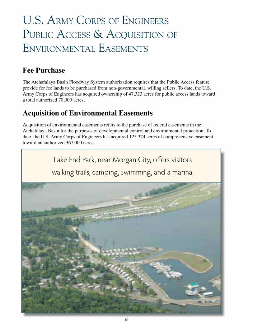
45
u.s. Army corPs of engineers PuBlic Access & AcQuisiTion of environmenTAl eAsemenTs
Fee Purchase
The Atchafalaya Basin Floodway System authorization requires that the Public Access feature provide for fee lands to be purchased from non-governmental, willing sellers. To date, the U.S. Army Corps of Engineers has acquired ownership of 47,323 acres for public access lands toward a total authorized 70,000 acres.
Acquisition of Environmental Easements Acquisition of environmental easements refers to the purchase of federal easements in the Atchafalaya Basin for the purposes of developmental control and environmental protection. To date, the U.S. Army Corps of Engineers has acquired 125,374 acres of comprehensive easement toward an authorized 367,000 acres.
Lake End Park, near Morgan City, offers visitors
walking trails, camping, swimming, and a marina.

46
APPendix

47

48

49

50
51

52
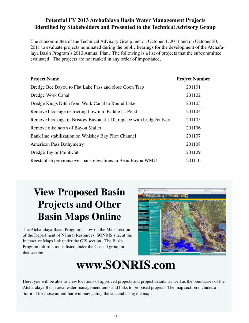
PotentialFY2013AtchafalayaBasinWaterManagementProjectsIdentifiedbyStakeholdersandPresentedtotheTechnicalAdvisoryGroup
The subcommittee of the Technical Advisory Group met on October 4, 2011 and on October 20, 2011 to evaluate projects nominated during the public hearings for the development of the Atchafa-laya Basin Program’s 2013 Annual Plan. The following is a list of projects that the subcommittee evaluated. The projects are not ranked in any order of importance.
Project Name Project NumberDredge Bee Bayou to Flat Lake Pass and close Coon Trap 201101
Dredge Work Canal 201102
Dredge Kings Ditch from Work Canal to Round Lake 201103
Remove blockage restricting flow into Paddie U. Pond 201104
Remove blockage in Bristow Bayou at I-10, replace with bridge/culvert 201105
Remove dike north of Bayou Mallet 201106
Bank line stabilization on Whiskey Bay Pilot Channel 201107
American Pass Bathymetry 201108
Dredge Taylor Point Cut 201109
Reestablish previous over-bank elevations in Beau Bayou WMU 201110
53
View Proposed Basin Projects and Other Basin Maps Online
The Atchafalaya Basin Program is now on the Maps section of the Department of Natural Resources’ SONRIS site, at the Interactive Maps link under the GIS section. The Basin Program information is listed under the Coastal group in that section.
www.SONRIS.comHere, you will be able to view locations of approved projects and project details, as well as the boundaries of the Atchafalaya Basin area, water management units and links to proposed projects. The map section includes a tutorial for those unfamiliar with navigating the site and using the maps.

54
AcknoWledgemenTs & sourcesInformationincludedintheFY2013AnnualPlanwascompiledfromavarietyofsources,including state and federal agencies, organizations and individuals, as well as books, publications and web sites produced by these sources. We thank everyone for their contributions and assistance.
Atchafalaya Basin Program
Louisiana Department of Natural Resources
Louisiana Department of Wildlife and Fisheries
Louisiana Department of Culture, Recreation and Tourism
Louisiana State University Agricultural Center
Louisiana Geological Survey
U.S. Army Corps of Engineers
U.S. Department of Agriculture U.S. Geological Survey
Atchafalaya Basinkeeper
Greg Guirard and C. Ray Brassieur, authors of Inherit the Atchafalaya (2007)
Mark A. Rees and Patrick C. Livingood, editors of Plaquemine Archaeology (2006)
Guirard, Greg, C. Ray Brassieur, and Louisiana Dept. of Natural Resources. Inherit theAtchafalaya. New York: University of Louisiana at Lafayette, Center for Louisiana Studies, 2007.
U.S. Army Corps of Engineers, New Orleans District. The Atchafalaya Basin Project. Brochure. New Orleans: Author.
U.S. Army Corps of Engineers, New Orleans District. Old River Control. Brochure. New Orleans: Author.
2007 Plaquemine Mounds of the Western Atchafalaya Basin. In Plaquemine Archaeology, edited by Mark A. Rees and Patrick C. Livingood, pp. 66-93. University of Alabama Press, Tuscaloosa.
United States Geological Survey. The Atchafalaya Basin -- River of Trees. United States Geological Survey, 2001. Print.
“The Atchafalaya Basin.” LaCoast.gov. Web. 26 Oct. 2011. <http://lacoast.gov/new/About/Basin_data/at/Default.aspx>.
“DNR Atchafalaya Basin Program and Boy Scouts Plant More Trees This Spring.” Dnr.louisiana.gov. Louisiana Department of Natural Resources, 26 Mar. 2011. Web. 26 Oct. 2011. <http://dnr.louisiana.gov/index.cfm?md=newsroom&tmp=detail&aid=848>.
“Atchafalaya Basin.” U.S. Army Corps of Engineers New Orleans District. Web. 26 Oct. 2011. <http://www.mvn.usace.army.mil/recreation/rec_atchafalaya.asp>.
Atchafalaya Basin Program NRIAS. Web. 26 Oct. 2011. <http://abp.cr.usgs.gov/>.
Department of Natural Resources | State of Louisiana. Web. 26 Oct. 2011. <http://dnr.louisiana.gov/index.cfm?md=pagebuilder>.
Atchafalaya Basinkeeper. Web. 26 Oct. 2011. <http://www.basinkeeper.org/>.
“Statistics.” Louisiana Department of Wildlife and Fisheries. Web. 26 Oct. 2011. <http://www.wlf.louisiana.gov/licenses/sta-tistics>.
“Louisiana--USGS Fact Sheet 019-99.” USGS Publications Warehouse. Web. 26 Oct. 2011. <http://pubs.usgs.gov/fs/fs-019-99/>.

55

Atchafalaya Basin ProgramLouisiana Department of Natural ResourcesP.O. Box 94396Baton Rouge, LA 70804-9396phone: (225) 342-6437 • fax: (225) 342-6887www.Basin.la.gov
This document was published at a total cost of $X,XXX.XX. Three hundred (300) cop-ies of this public document were published in the second printing at a cost of $XXX.XX. The total cost of all printings of this document, including reprints, is $X,XXX.XX. This document was published in-house by the Louisiana Department of Natural Resources, Atchafalaya Basin Program to comply with Act 606 of the 2008 Regular Session of the Louisiana Legislature, which requires the development and publication of an Annual Plan for the Atchafalaya Basin Program. This material was printed in ac-cordance with the standards for printing by state agencies established pursuant to R.S. 43:31.