swan lake roject ideas - bellevue, washington · lake lake bellevue lake larsen lake boren phantom...
TRANSCRIPT
Lake
LakeBellevue
LakeLarsen
Lake
Boren
Phantom
Yarrow
CozyCove
Bay
Bay
Meydenbauer
ClydeLoch
SwanLake
WashingtonLake
SammamishLake
WashingtonLake
NE 2ND ST
106T
H A
V N
E
RED
SE
66
NE
ST
BLVD
SE 8TH ST
130T
H A
V N
E
ROAD
132N
D
AV
NE
164T
HAV
SE
173R
DN
E
104T
H A
V S
E
STREET
108T
H
AVE
S
E
STREETNE
123R
D
A
V
S
E
KAMBER
168T
H
AV
S
E
DRIVE
SE
116T
H
AV
S
E
SE
148T
H
AV
DRIVE
ST
PKW
Y
116T
H STREET
AVE
NU
E N
E
SE 60TH STSE 62ND PL
PARKW
AY
100T
H A
VE
NU
E N
E
92N
D A
VE
NU
E N
E
156T
H
SOM
ERSET
150T
H
AV
S
E
161S
T
NE 4TH ST
NE 10TH ST
NE 30TH ST
WAY
LAKE
MO
NT
BLVD
SE
BLVD
CO
ALC
REE
K
10
OLD BELRD
SE
AV
67
SE 46
SE
118T
H
A
V
S
E
LAKEMO
NT BLVD
SE
SE
120T
H A
V N
E
SE 36TH ST
NE 14 ST
NE 8TH ST
RO
AD
RO
AD
PY
AV
AV
112T
H
AV
S
E
60TH
BLVD SE
NEWPORT
DR
SE
166TH WY SE
W LAKE
NEWCASTLE WAY
SE 34TH ST
BELLEVUE
NE
WAY14
0TH
AV
EN
UE
NE
148T
H A
VE
NU
E N
E
116T
H A
VE
SE
LK W
ASH
BLVD
SE
SE 22ND ST
SE
W L
AKE
BELLEVUE-R
EDMOND ROAD
LAKE WASHINGTON BLVD NE
63RD
EASTGATESE
SE
NE 12TH ST
116T
H
AV
N
E
46THSE
SE
114TH AV SE
PL SE
110T
H A
V N
E
128
SE WAY
NE 20TH STREET
NE 8TH STREET
8THSE
HILLS
LAKE
120T
H
124T
H
AV
N
E
AV
128T
H
AV
S
E
SE 16TH STSA
MM
AMIS
H
FOREST
160T
H AV
E SE
124T
H
AV
SE
HIGHLAND
VILLAGE
WAY
PARK DR SE
SE 26
ST40THNE
NEWCASTLE GOLF CLUB RD
NE 24TH STREET
140T
H A
VE
NU
E N
E
MAIN
164T
HAV
EN
UE
NE
NORTHUP
134T
H A
VE
NU
E N
E
COAL CREEK
NORTHUP W
AY
SEST
SE
WAY
164T
H
AV
SE
RICH
ARDS
NE 8TH ST
BE
LLE
VU
E W
AY N
E
116T
H A
VE
NU
E N
E
WAY
152N
DSE
AV
NEWPORT
123R
D A
V S
E
LKW
ASH
129TH
PKW
Y
SE
NE
PL
MT
24TH
AV
NE
BELLEVUE-REDMOND
WAY
24TH
112T
H A
VE
SE
BE
LLE
VU
E W
AY
SE 24TH ST
SE
150T
H A
V S
E
119T
H
FAC
TOR
IA B
LVD
SE
NE
SAMMAMISH
Lake Hills Connector
145TH PL SE
156T
H
AVE
NU
E
AVE
NU
E N
E
108T
H A
VE
NU
E N
E
132N
D A
VE
NU
E N
E
LAK
E W
AS
HIN
GTO
N B
LVD
NE
COUGAR
AVE
NU
E
148T
H
MAIN STREET
108T
H A
VE
NU
E N
E
112T
H A
VE
NU
E N
E
SO
ME
RS
ET
ST
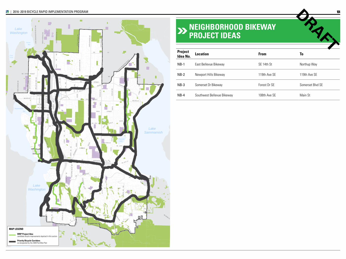
Project Idea No. Location From To
NB-1 East Bellevue Bikeway SE 14th St Northup Way
NB-2 Newport Hills Bikeway 119th Ave SE 119th Ave SE
NB-3 Somerset Dr Bikeway Forest Dr SE Somerset Blvd SE
NB-4 Southwest Bellevue Bikeway 108th Ave SE Main St
DRAFTNEIghBORhOOD BIkEWAy PROjECT IDEAS
104IMPLEMENTATION INITIATIVE_|_2016–2019 BiCYCLE rAPiD iMPLEMENTATiON PrOgrAM
BRIP Project Ideacandidate bicycle improvements depicted in this section
Priority Bicycle Corridorsas designated by the 2009 Ped-Bike Plan
MAP LEGEND
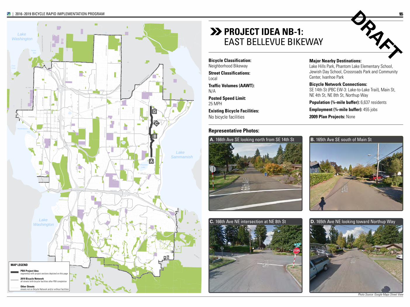
Photo Source: Google Maps Street View
Lake
LakeBellevue
LakeLarsen
Lake
Boren
Phantom
Yarrow
CozyCove
Bay
Bay
Meydenbauer
ClydeLoch
SwanLake
WashingtonLake
SammamishLake
WashingtonLake
NE 2ND ST
106T
H A
V N
E
RED
SE
66
NE
ST
BLVD
SE 8TH ST
130T
H A
V N
E ROAD
132N
D
AV
NE
164T
HAV
SE
173R
DN
E
104T
H A
V S
E
STREET
108T
H
AVE
S
E
STREETNE
123R
D
A
V
S
E
KAMBER
168T
H
AV
S
E
DRIVE
SE
116T
H
AV
S
E
SE
148T
H
AV
DRIVE
ST
PKW
Y
116T
H
STREET
AVE
NU
E N
E
SE 60TH ST
SE 62ND PL
PARKW
AY
100T
H A
VE
NU
E N
E
92N
D A
VE
NU
E N
E
156T
H
SOM
ERSET
150T
H
AV
S
E
161S
T
NE 4TH ST
NE 10TH ST
NE 30TH ST
WAY
LAKE
MO
NT
BLVD
SE
BLVD
CO
AL
CR
EEK
10
OLD BELRD
SE
AV
67
SE 46
SE
118T
H
A
V
S
E
LAKEMO
NT BLVD
SE
SE
120T
H A
V N
E
SE 36TH ST
NE 14 ST
NE 8TH ST
RO
AD
RO
AD
PY
AV
AV
112T
H
AV
S
E
60TH
BLVD SE
NEWPORT
DR
SE
166TH WY SE
W LAKE
NEWCASTLE WAY
SE 34TH ST
BELLEVUE
NE
WAY14
0TH
AV
EN
UE
NE
148T
H A
VE
NU
E N
E
116T
H A
VE
SE
LK W
ASH
BLVD
SE
SE 22ND ST
SE
W L
AKE
BELLEVUE-R
EDMOND ROAD
LAKE WASHINGTON BLVD NE
63RD
EASTGATESE
SE
NE 12TH ST
116T
H
AV
N
E
46THSE
SE
114TH AV SE
PL SE
110T
H A
V N
E
128
SE WAY
NE 20TH STREET
NE 8TH STREET
8THSE
HILLS
LAKE
120T
H
124T
H
AV
N
E
AV
128T
H
AV
S
E
SE 16TH STSA
MM
AMIS
H
FOREST
160T
H AV
E SE
124T
H
AV
SE
HIGHLAND
VILLAGE
WAY
PARK DR SE
SE 26
ST40THNE
NEWCASTLE GOLF CLUB RD
NE 24TH STREET
140T
H A
VE
NU
E N
E
MAIN
164T
HAV
EN
UE
NE
NORTHUP
134T
H A
VE
NU
E N
E
COAL CREEK
NE NORTHUP W
AY
SEST
SE
WAY
164T
H
AV
SE
RICH
ARDS
NE 8TH ST
116T
H A
VE
NU
E N
E
WAY
152N
DSE
AV
NEWPORT
123R
D A
V S
E
LKW
ASH
129TH
PKW
Y
SE
NE
PL
MT
24TH
AV
NE
BELLEVUE-REDMOND
WAY
24TH
112T
H A
VE
SE
BE
LLE
VU
E W
AY
SE 24TH ST
SE
150T
H A
V S
E
119T
H
FAC
TOR
IA B
LVD
SE
NE
SAMMAMISH
Lake Hills Connector
145TH PL SE
156T
H
AVE
NU
E
AVE
NU
E N
E
108T
H A
VE
NU
E N
E
132N
D A
VE
NU
E N
E
LAK
E W
AS
HIN
GTO
N B
LVD
NE
COUGAR
AVE
NU
E
148T
H
MAIN STREET
108T
H A
VE
NU
E N
E
112T
H A
VE
NU
E N
E
SO
ME
RS
ET
ST
BE
LLE
VU
E W
AY
A
C
D
BB. 165th Ave SE south of Main St
D. 165th Ave NE looking toward Northup WayC. 166th Ave NE intersection at NE 8th St
A. 166th Ave SE looking north from SE 14th St
DRAFTMajor Nearby Destinations: Lake Hills Park, Phantom Lake Elementary School, Jewish Day School, Crossroads Park and Community Center, Ivanhoe Park
Bicycle Network Connections: SE 14th St (PBC EW-3: Lake-to-Lake Trail), Main St, NE 4th St, NE 8th St, Northup Way
Population (¼-mile buffer): 6,637 residents
Employment (¼-mile buffer): 455 jobs
2009 Plan Projects: None
Representative Photos:
Bicycle Classification: Neighborhood Bikeway
Street Classifications: Local
Traffic Volumes (AAWT): N/A
Posted Speed Limit: 25 MPH
Existing Bicycle Facilities: No bicycle facilities
PROjECT IDEA NB-1:EAST BELLEVuE BikEWAY
105IMPLEMENTATION INITIATIVE_|_2016–2019 BICYCLE RAPID IMPLEMENTATION PROGRAM
PBII Project Ideasegment(s) with project sections depicted on this page
2019 Bicycle Networkall streets with bicycle facilities after PBII completion
Other Streetsstreets not on Bicycle Network and/or without facilities
MAP LEGEND
Priority Bicycle Corridorsegment(s) with project sections depicted on this page
Priority Bicycle Corridorremainder of corridor
Planned ConnectionsBicycle facilities along Priority Bicycle Corridors
Nominal AccommodationsUnmarked shared roadways along Cross-City Corridors
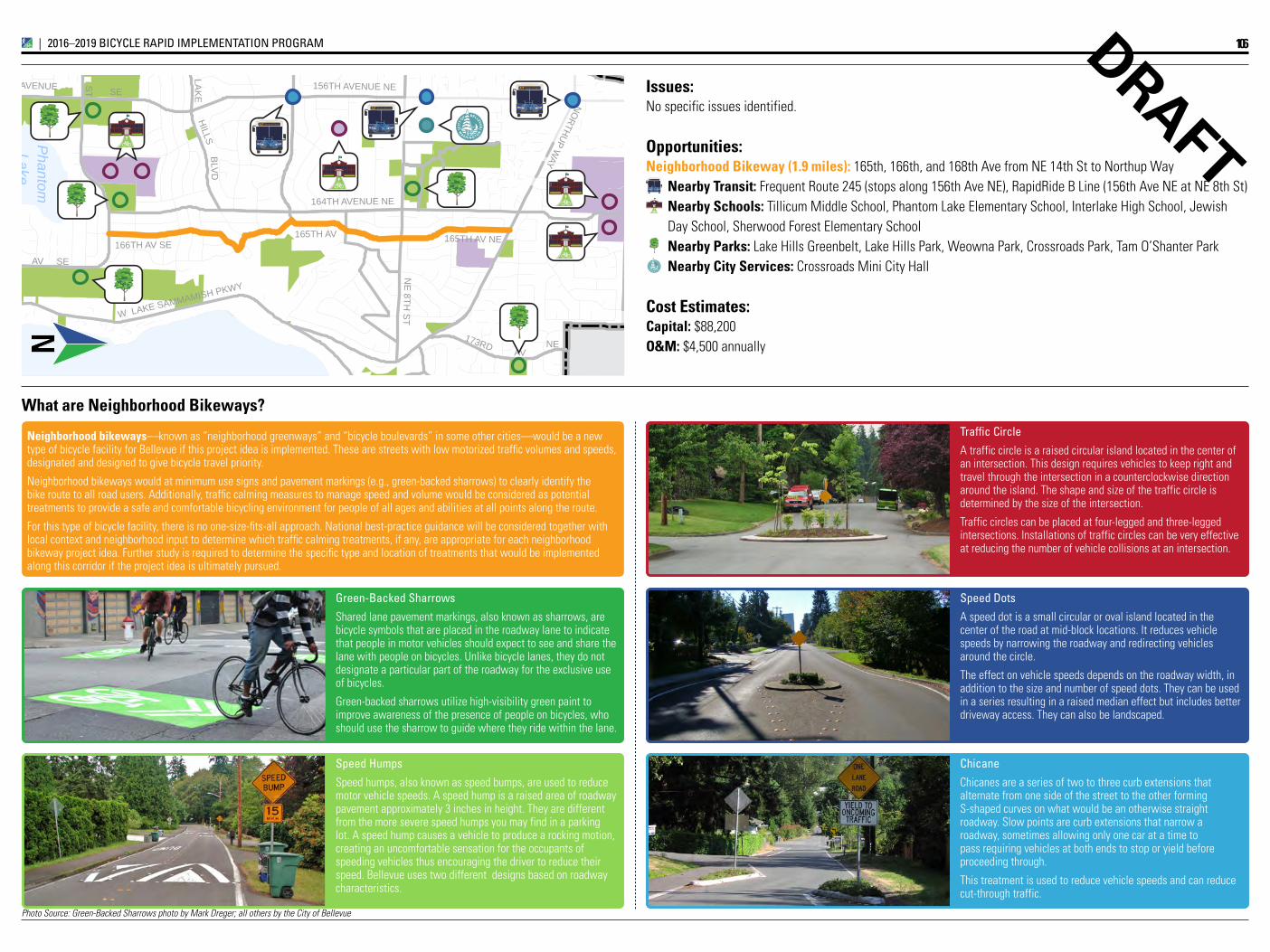
Photo Source: Green-Backed Sharrows photo by Mark Dreger; all others by the City of Bellevue
LakeP
hantom
BLV
D
173RD NE
STR
EE
T
168TH AV SE
STR
EE
T
NE
8TH S
TW LAKE SAMMAMISH PKWY
SE
HILLS
LAK
E
AV
SE
16TH S
T
NORTHUP W
AY 24TH
AVENUE 156TH AVENUE NE
164TH AVENUE NE
166TH AV SE165TH AV 165TH AV NE
A2T Access to Transit
A2T Access to Transit
A2T Access to Transit
N
DRAFT
Speed Humps
Speed humps, also known as speed bumps, are used to reduce motor vehicle speeds. A speed hump is a raised area of roadway pavement approximately 3 inches in height. They are different from the more severe speed humps you may find in a parking lot. A speed hump causes a vehicle to produce a rocking motion, creating an uncomfortable sensation for the occupants of speeding vehicles thus encouraging the driver to reduce their speed. Bellevue uses two different designs based on roadway characteristics.
Neighborhood bikeways—known as “neighborhood greenways” and “bicycle boulevards” in some other cities—would be a new type of bicycle facility for Bellevue if this project idea is implemented. These are streets with low motorized traffic volumes and speeds, designated and designed to give bicycle travel priority.
Neighborhood bikeways would at minimum use signs and pavement markings (e.g., green-backed sharrows) to clearly identify the bike route to all road users. Additionally, traffic calming measures to manage speed and volume would be considered as potential treatments to provide a safe and comfortable bicycling environment for people of all ages and abilities at all points along the route.
For this type of bicycle facility, there is no one-size-fits-all approach. National best-practice guidance will be considered together with local context and neighborhood input to determine which traffic calming treatments, if any, are appropriate for each neighborhood bikeway project idea. Further study is required to determine the specific type and location of treatments that would be implemented along this corridor if the project idea is ultimately pursued.
What are Neighborhood Bikeways?
green-Backed Sharrows
Shared lane pavement markings, also known as sharrows, are bicycle symbols that are placed in the roadway lane to indicate that people in motor vehicles should expect to see and share the lane with people on bicycles. Unlike bicycle lanes, they do not designate a particular part of the roadway for the exclusive use of bicycles.
Green-backed sharrows utilize high-visibility green paint to improve awareness of the presence of people on bicycles, who should use the sharrow to guide where they ride within the lane.
Traffic Circle
A traffic circle is a raised circular island located in the center of an intersection. This design requires vehicles to keep right and travel through the intersection in a counterclockwise direction around the island. The shape and size of the traffic circle is determined by the size of the intersection.
Traffic circles can be placed at four-legged and three-legged intersections. Installations of traffic circles can be very effective at reducing the number of vehicle collisions at an intersection.
Speed Dots
A speed dot is a small circular or oval island located in the center of the road at mid-block locations. It reduces vehicle speeds by narrowing the roadway and redirecting vehicles around the circle.
The effect on vehicle speeds depends on the roadway width, in addition to the size and number of speed dots. They can be used in a series resulting in a raised median effect but includes better driveway access. They can also be landscaped.
Chicane
Chicanes are a series of two to three curb extensions that alternate from one side of the street to the other forming S-shaped curves on what would be an otherwise straight roadway. Slow points are curb extensions that narrow a roadway, sometimes allowing only one car at a time to pass requiring vehicles at both ends to stop or yield before proceeding through.
This treatment is used to reduce vehicle speeds and can reduce cut-through traffic.
Issues:No specific issues identified.
Opportunities:Neighborhood Bikeway (1.9 miles): 165th, 166th, and 168th Ave from NE 14th St to Northup Way
Nearby Transit: Frequent Route 245 (stops along 156th Ave NE), RapidRide B Line (156th Ave NE at NE 8th St)Nearby Schools: Tillicum Middle School, Phantom Lake Elementary School, Interlake High School, JewishDay School, Sherwood Forest Elementary SchoolNearby Parks: Lake Hills Greenbelt, Lake Hills Park, Weowna Park, Crossroads Park, Tam O’Shanter ParkNearby City Services: Crossroads Mini City Hall
Cost Estimates:Capital: $88,200O&M: $4,500 annually
A2T Access to Transit
106IMPLEMENTATION INITIATIVE_|_2016–2019 BICYCLE RAPID IMPLEMENTATION PROGRAM
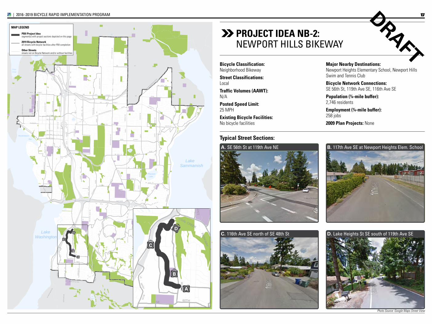
Photo Source: Google Maps Street View
Lake
LakeBellevue
LakeLarsen
Lake
Boren
Phantom
Yarrow
CozyCove
Bay
Bay
Meydenbauer
ClydeLoch
SwanLake
WashingtonLake
SammamishLake
WashingtonLake
NE 2ND ST
106T
H A
V N
E
RED
SE
66
NE
ST
BLVD
SE 8TH ST
130T
H A
V N
E ROAD
132N
D
AV
NE
164T
HAV
SE
173R
DN
E
104T
H A
V S
E
STREET
108T
H
AVE
S
E
STREETNE
123R
D
A
V
S
E
KAMBER
168T
H
AV
S
E
DRIVE
SE
116T
H
AV
S
E
SE
148T
H
AV
DRIVE
ST
PKW
Y
116T
H
STREET
AVE
NU
E N
E
SE 60TH ST
SE 62ND PL
PARKW
AY
100T
H A
VE
NU
E N
E
92N
D A
VE
NU
E N
E
156T
H
SOM
ERSET
150T
H
AV
S
E
161S
T
NE 4TH ST
NE 10TH ST
NE 30TH ST
WAY
LAKE
MO
NT
BLVD
SE
BLVD
CO
AL
CR
EEK
10
OLD BELRD
SE
AV
67
SE 46
SE
118T
H
A
V
S
E
LAKEMO
NT BLVD
SE
SE
120T
H A
V N
E
SE 36TH ST
NE 14 ST
NE 8TH ST
RO
AD
RO
AD
PY
AV
AV
112T
H
AV
S
E
60TH
BLVD SE
NEWPORT
DR
SE
166TH WY SE
W LAKE
NEWCASTLE WAY
SE 34TH ST
BELLEVUE
NE
WAY14
0TH
AV
EN
UE
NE
148T
H A
VE
NU
E N
E
116T
H A
VE
SE
LK W
ASH
BLVD
SE
SE 22ND ST
SE
W L
AKE
BELLEVUE-R
EDMOND ROAD
LAKE WASHINGTON BLVD NE
63RD
EASTGATESE
SE
NE 12TH ST
116T
H
AV
N
E
46THSE
SE
114TH AV SE
PL SE
110T
H A
V N
E
128
SE WAY
NE 20TH STREET
NE 8TH STREET
8THSE
HILLS
LAKE
120T
H
124T
H
AV
N
E
AV
128T
H
AV
S
E
SE 16TH STSA
MM
AMIS
H
FOREST
160T
H AV
E SE
124T
H
AV
SE
HIGHLAND
VILLAGE
WAY
PARK DR SE
SE 26
ST40THNE
NEWCASTLE GOLF CLUB RD
NE 24TH STREET
140T
H A
VE
NU
E N
E
MAIN
164T
HAV
EN
UE
NE
NORTHUP
134T
H A
VE
NU
E N
E
COAL CREEK
NE NORTHUP W
AY
SEST
SE
WAY
164T
H
AV
SE
RICH
ARDS
NE 8TH ST
116T
H A
VE
NU
E N
E
WAY
152N
DSE
AV
NEWPORT
123R
D A
V S
E
LKW
ASH
129TH
PKW
Y
SE
NE
PL
MT
24TH
AV
NE
BELLEVUE-REDMOND
WAY
24TH
112T
H A
VE
SE
BE
LLE
VU
E W
AY
SE 24TH ST
SE
150T
H A
V S
E
119T
H
FAC
TOR
IA B
LVD
SE
NE
SAMMAMISH
Lake Hills Connector
145TH PL SE
156T
H
AVE
NU
E
AVE
NU
E N
E
108T
H A
VE
NU
E N
E
132N
D A
VE
NU
E N
E
LAK
E W
AS
HIN
GTO
N B
LVD
NE
COUGAR
AVE
NU
E
148T
H
MAIN STREET
108T
H A
VE
NU
E N
E
112T
H A
VE
NU
E N
E
SO
ME
RS
ET
ST
BE
LLE
VU
E W
AY
A
B
C
D
Lake
LakeBellevue
LakeLarsen
Lake
Boren
Phantom
Yarrow
CozyCove
Bay
Bay
Meydenbauer
ClydeLoch
SwanLake
WashingtonLake
SammamishLake
WashingtonLake
NE 2ND ST
106T
H A
V N
E
RED
SE
66
NE
ST
BLVD
SE 8TH ST
130T
H A
V N
E ROAD
132N
D
AV
NE
164T
HAV
SE
173R
DN
E
104T
H A
V S
E
STREET
108T
H
AVE
S
E
STREETNE
123R
D
A
V
S
E
KAMBER
168T
H
AV
S
E
DRIVE
SE
116T
H
AV
S
E
SE14
8TH
AV
DRIVE
ST
PKW
Y
116T
H
STREET
AVE
NU
E N
E
SE 60TH ST
SE 62ND PL
PARKW
AY
100T
H A
VE
NU
E N
E
92N
D A
VE
NU
E N
E
156T
H
SOM
ERSET
150T
H
AV
S
E
161S
T
NE 4TH ST
NE 10TH ST
NE 30TH ST
WAY
LAKE
MO
NT
BLVD
SE
BLVD
CO
AL
CR
EEK
10
OLD BELRD
SE
AV
67
SE 46
SE
118T
H
A
V
S
E
LAKEMO
NT BLVD
SE
SE
120T
H A
V N
E
SE 36TH ST
NE 14 ST
NE 8TH ST
RO
AD
RO
AD
PY
AV
AV
112T
H
AV
S
E
60TH
BLVD SE
NEWPORT
DR
SE
166TH WY SE
W LAKE
NEWCASTLE WAY
SE 34TH ST
BELLEVUE
NE
WAY
140T
H A
VE
NU
E N
E
148T
H A
VE
NU
E N
E
116T
H A
VE
SE
LK W
ASH
BLVD
SE
SE 22ND ST
SE
W L
AKE
BELLEVUE-R
EDMOND ROAD
LAKE WASHINGTON BLVD NE
63RD
EASTGATESE
SE
NE 12TH ST
116T
H
AV
N
E
46THSE
SE
114TH AV SE
PL SE
110T
H A
V N
E
128
SE WAY
NE 20TH STREET
NE 8TH STREET
8THSE
HILLS
LAKE
120T
H
124T
H
AV
N
E
AV
128T
H
AV
S
E
SE 16TH ST
SAM
MAM
ISH
FOREST
160T
H AV
E SE
124T
H
AV
SE
HIGHLAND
VILLAGE
WAY
PARK DR SE
SE 26
ST40THNE
NEWCASTLE GOLF CLUB RD
NE 24TH STREET
140T
H A
VE
NU
E N
E
MAIN
164T
HAV
EN
UE
NE
NORTHUP
134T
H A
VE
NU
E N
E
COAL CREEK
NE NORTHUP W
AY
SEST
SE
WAY
164T
H
AV
SE
RICH
ARDS
NE 8TH ST
116T
H A
VE
NU
E N
E
WAY
152N
DSE
AV
NEWPORT
123R
D A
V S
E
LKW
ASH
129TH
PKW
Y
SE
NE
PL
MT
24TH
AV
NE
BELLEVUE-REDMOND
WAY
24TH
112T
H A
VE
SE
BE
LLE
VU
E W
AYSE 24TH ST
SE
150T
H A
V S
E
119T
H
FAC
TOR
IA B
LVD
SE
NE
SAMMAMISH
Lake Hills Connector
145TH PL SE
156T
H
AVE
NU
E
AVE
NU
E N
E
108T
H A
VE
NU
E N
E
132N
D A
VE
NU
E N
E
LAK
E W
AS
HIN
GTO
N B
LVD
NE
COUGAR
AVE
NU
E
148T
H
MAIN STREET
108T
H A
VE
NU
E N
E
112T
H A
VE
NU
E N
E
SO
ME
RS
ET
ST
BE
LLE
VU
E W
AY
A
B
C
D
B. 117th Ave SE at Newport Heights Elem. School
D. Lake Heights St SE south of 119th Ave SE C. 116th Ave SE north of SE 48th St
A. SE 56th St at 119th Ave NE
Typical Street Sections:
DRAFTMajor Nearby Destinations: Newport Heights Elementary School, Newport Hills Swim and Tennis Club
Bicycle Network Connections: SE 56th St, 119th Ave SE, 116th Ave SE
Population (¼-mile buffer): 2,746 residents
Employment (¼-mile buffer): 258 jobs
2009 Plan Projects: None
Bicycle Classification: Neighborhood Bikeway
Street Classifications: Local
Traffic Volumes (AAWT): N/A
Posted Speed Limit: 25 MPH
Existing Bicycle Facilities: No bicycle facilities
PROjECT IDEA NB-2:NEWPOrT HiLLS BikEWAY
107IMPLEMENTATION INITIATIVE_|_2016–2019 BICYCLE RAPID IMPLEMENTATION PROGRAM
PBII Project Ideasegment(s) with project sections depicted on this page
2019 Bicycle Networkall streets with bicycle facilities after PBII completion
Other Streetsstreets not on Bicycle Network and/or without facilities
MAP LEGEND
Priority Bicycle Corridorsegment(s) with project sections depicted on this page
Priority Bicycle Corridorremainder of corridor
Planned ConnectionsBicycle facilities along Priority Bicycle Corridors
Nominal AccommodationsUnmarked shared roadways along Cross-City Corridors
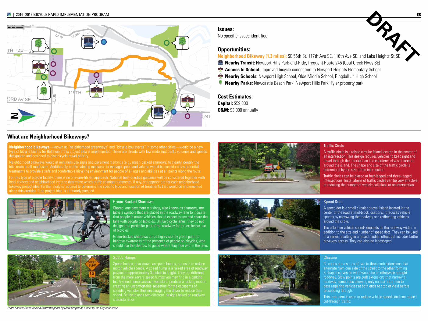
Photo Source: Green-Backed Sharrows photo by Mark Dreger; all others by the City of Bellevue
Washington
SE
116TH AV SE SE
PARKWAY
BLVD
AV
112TH AV SE
60TH
124TH AV SE
CO
AL CR
EEK
123RD AV SE
LKWASH
119TH
A2T Access to Transit
A2T Access to Transit
N
DRAFT
Speed Humps
Speed humps, also known as speed bumps, are used to reduce motor vehicle speeds. A speed hump is a raised area of roadway pavement approximately 3 inches in height. They are different from the more severe speed humps you may find in a parking lot. A speed hump causes a vehicle to produce a rocking motion, creating an uncomfortable sensation for the occupants of speeding vehicles thus encouraging the driver to reduce their speed. Bellevue uses two different designs based on roadway characteristics.
Neighborhood bikeways—known as “neighborhood greenways” and “bicycle boulevards” in some other cities—would be a new type of bicycle facility for Bellevue if this project idea is implemented. These are streets with low motorized traffic volumes and speeds, designated and designed to give bicycle travel priority.
Neighborhood bikeways would at minimum use signs and pavement markings (e.g., green-backed sharrows) to clearly identify the bike route to all road users. Additionally, traffic calming measures to manage speed and volume would be considered as potential treatments to provide a safe and comfortable bicycling environment for people of all ages and abilities at all points along the route.
For this type of bicycle facility, there is no one-size-fits-all approach. National best-practice guidance will be considered together with local context and neighborhood input to determine which traffic calming treatments, if any, are appropriate for each neighborhood bikeway project idea. Further study is required to determine the specific type and location of treatments that would be implemented along this corridor if the project idea is ultimately pursued.
What are Neighborhood Bikeways?
green-Backed Sharrows
Shared lane pavement markings, also known as sharrows, are bicycle symbols that are placed in the roadway lane to indicate that people in motor vehicles should expect to see and share the lane with people on bicycles. Unlike bicycle lanes, they do not designate a particular part of the roadway for the exclusive use of bicycles.
Green-backed sharrows utilize high-visibility green paint to improve awareness of the presence of people on bicycles, who should use the sharrow to guide where they ride within the lane.
Traffic Circle
A traffic circle is a raised circular island located in the center of an intersection. This design requires vehicles to keep right and travel through the intersection in a counterclockwise direction around the island. The shape and size of the traffic circle is determined by the size of the intersection.
Traffic circles can be placed at four-legged and three-legged intersections. Installations of traffic circles can be very effective at reducing the number of vehicle collisions at an intersection.
Speed Dots
A speed dot is a small circular or oval island located in the center of the road at mid-block locations. It reduces vehicle speeds by narrowing the roadway and redirecting vehicles around the circle.
The effect on vehicle speeds depends on the roadway width, in addition to the size and number of speed dots. They can be used in a series resulting in a raised median effect but includes better driveway access. They can also be landscaped.
Chicane
Chicanes are a series of two to three curb extensions that alternate from one side of the street to the other forming S-shaped curves on what would be an otherwise straight roadway. Slow points are curb extensions that narrow a roadway, sometimes allowing only one car at a time to pass requiring vehicles at both ends to stop or yield before proceeding through.
This treatment is used to reduce vehicle speeds and can reduce cut-through traffic.
Issues:No specific issues identified.
Opportunities:Neighborhood Bikeway (1.3 miles): SE 56th St, 117th Ave SE, 116th Ave SE, and Lake Heights St SE
Nearby Transit: Newport Hills Park-and-Ride, frequent Route 245 (Coal Creek Pkwy SE)Access to School: Improved bicycle connection to Newport Heights Elementary SchoolNearby Schools: Newport High School, Olde Middle School, Ringdall Jr. High SchoolNearby Parks: Newcastle Beach Park, Newport Hills Park, Tyler property park
Cost Estimates:Capital: $59,300O&M: $3,000 annually
A2T Access to Transit
108IMPLEMENTATION INITIATIVE_|_2016–2019 BICYCLE RAPID IMPLEMENTATION PROGRAM
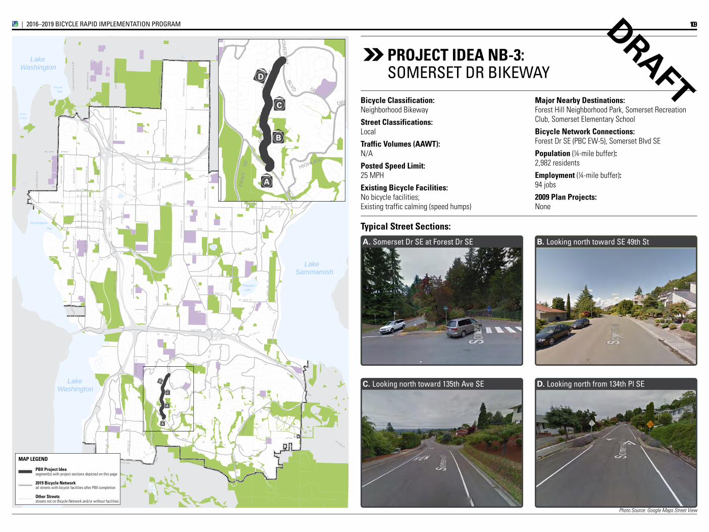
Photo Source: Google Maps Street View
Lake
LakeBellevue
LakeLarsen
Lake
Boren
Phantom
Yarrow
CozyCove
Bay
Bay
Meydenbauer
ClydeLoch
SwanLake
WashingtonLake
SammamishLake
WashingtonLake
NE 2ND ST
106T
H A
V N
E
RED
SE
66
NE
ST
BLVD
SE 8TH ST
130T
H A
V N
E ROAD
132N
D
AV
NE
164T
HAV
SE
173R
DN
E
104T
H A
V S
E
STREET
108T
H
AVE
S
E
STREETNE
123R
D
A
V
S
E
KAMBER
168T
H
AV
S
E
DRIVE
SE
116T
H
AV
S
E
SE
148T
H
AV
DRIVE
ST
PKW
Y
116T
H
STREET
AVE
NU
E N
E
SE 60TH ST
SE 62ND PL
PARKW
AY
100T
H A
VE
NU
E N
E
92N
D A
VE
NU
E N
E
156T
H
SOM
ERSET
150T
H
AV
S
E
161S
T
NE 4TH ST
NE 10TH ST
NE 30TH ST
WAY
LAKE
MO
NT
BLVD
SE
BLVD
CO
AL
CR
EEK
10
OLD BELRD
SE
AV
67
SE 46
SE
118T
H
A
V
S
E
LAKEMO
NT BLVD
SE
SE
120T
H A
V N
E
SE 36TH ST
NE 14 ST
NE 8TH ST
RO
AD
RO
AD
PY
AV
AV
112T
H
AV
S
E
60TH
BLVD SE
NEWPORT
DR
SE
166TH WY SE
W LAKE
NEWCASTLE WAY
SE 34TH ST
BELLEVUE
NE
WAY14
0TH
AV
EN
UE
NE
148T
H A
VE
NU
E N
E
116T
H A
VE
SE
LK W
ASH
BLVD
SE
SE 22ND ST
SE
W L
AKE
BELLEVUE-R
EDMOND ROAD
LAKE WASHINGTON BLVD NE
63RD
EASTGATESE
SE
NE 12TH ST
116T
H
AV
N
E
46THSE
SE
114TH AV SE
PL SE
110T
H A
V N
E
128
SE WAY
NE 20TH STREET
NE 8TH STREET
8THSE
HILLS
LAKE
120T
H
124T
H
AV
N
E
AV
128T
H
AV
S
E
SE 16TH STSA
MM
AMIS
H
FOREST
160T
H AV
E SE
124T
H
AV
SE
HIGHLAND
VILLAGE
WAY
PARK DR SE
SE 26
ST40THNE
NEWCASTLE GOLF CLUB RD
NE 24TH STREET
140T
H A
VE
NU
E N
E
MAIN
164T
HAV
EN
UE
NE
NORTHUP
134T
H A
VE
NU
E N
E
COAL CREEK
NE NORTHUP W
AY
SEST
SE
WAY
164T
H
AV
SE
RICH
ARDS
NE 8TH ST
116T
H A
VE
NU
E N
E
WAY
152N
DSE
AV
NEWPORT
123R
D A
V S
E
LKW
ASH
129TH
PKW
Y
SE
NE
PL
MT
24TH
AV
NE
BELLEVUE-REDMOND
WAY
24TH
112T
H A
VE
SE
BE
LLE
VU
E W
AY
SE 24TH ST
SE
150T
H A
V S
E
119T
H
FAC
TOR
IA B
LVD
SE
NE
SAMMAMISH
Lake Hills Connector
145TH PL SE
156T
H
AVE
NU
E
AVE
NU
E N
E
108T
H A
VE
NU
E N
E
132N
D A
VE
NU
E N
E
LAK
E W
AS
HIN
GTO
N B
LVD
NE
COUGAR
AVE
NU
E
148T
H
MAIN STREET
108T
H A
VE
NU
E N
E
112T
H A
VE
NU
E N
E
SO
ME
RS
ET
ST
BE
LLE
VU
E W
AY
A
B
C
D
Lake
LakeBellevue
LakeLarsen
Lake
Boren
Phantom
Yarrow
CozyCove
Bay
Bay
Meydenbauer
ClydeLoch
SwanLake
WashingtonLake
SammamishLake
WashingtonLake
NE 2ND ST
106T
H A
V N
E
RED
SE
66
NE
ST
BLVD
SE 8TH ST
130T
H A
V N
E ROAD
132N
D
AV
NE
164T
HAV
SE
173R
DN
E
104T
H A
V S
E
STREET
108T
H
AVE
S
E
STREETNE
123R
D
A
V
S
E
KAMBER
168T
H
AV
S
E
DRIVE
SE
116T
H
AV
S
E
SE
148T
H
AV
DRIVE
ST
PKW
Y
116T
H
STREET
AVE
NU
E N
E
SE 60TH ST
SE 62ND PL
PARKW
AY
100T
H A
VE
NU
E N
E
92N
D A
VE
NU
E N
E
156T
H
SOM
ERSET
150T
H
AV
S
E
161S
T
NE 4TH ST
NE 10TH ST
NE 30TH ST
WAY
LAKE
MO
NT
BLVD
SE
BLVD
CO
AL
CR
EEK
10
OLD BELRD
SE
AV
67
SE 46
SE
118T
H
A
V
S
E
LAKEMO
NT BLVD
SE
SE
120T
H A
V N
E
SE 36TH ST
NE 14 ST
NE 8TH ST
RO
AD
RO
AD
PY
AV
AV
112T
H
AV
S
E
60TH
BLVD SE
NEWPORT
DR
SE
166TH WY SE
W LAKE
NEWCASTLE WAY
SE 34TH ST
BELLEVUE
NE
WAY
140T
H A
VE
NU
E N
E
148T
H A
VE
NU
E N
E
116T
H A
VE
SE
LK W
ASH
BLVD
SE
SE 22ND ST
SE
W L
AKE
BELLEVUE-R
EDMOND ROAD
LAKE WASHINGTON BLVD NE
63RD
EASTGATESE
SE
NE 12TH ST
116T
H
AV
N
E
46THSE
SE
114TH AV SE
PL SE
110T
H A
V N
E
128
SE WAY
NE 20TH STREET
NE 8TH STREET
8THSE
HILLS
LAKE
120T
H
124T
H
AV
N
E
AV
128T
H
AV
S
E
SE 16TH ST
SAM
MAM
ISH
FOREST
160T
H AV
E SE
124T
H
AV
SE
HIGHLAND
VILLAGE
WAY
PARK DR SESE 26
ST40THNE
NEWCASTLE GOLF CLUB RD
NE 24TH STREET
140T
H A
VE
NU
E N
E
MAIN
164T
HAV
EN
UE
NE
NORTHUP
134T
H A
VE
NU
E N
E
COAL CREEK
NE NORTHUP W
AY
SEST
SE
WAY
164T
H
AV
SE
RICH
ARDS
NE 8TH ST
116T
H A
VE
NU
E N
E
WAY
152N
DSE
AV
NEWPORT
123R
D A
V S
E
LKW
ASH
129TH
PKW
Y
SE
NE
PL
MT
24TH
AV
NE
BELLEVUE-REDMOND
WAY
24TH
112T
H A
VE
SE
BE
LLE
VU
E W
AY
SE 24TH ST
SE
150T
H A
V S
E
119T
H
FAC
TOR
IA B
LVD
SE
NE
SAMMAMISH
Lake Hills Connector
145TH PL SE
156T
H
AVE
NU
E
AVE
NU
E N
E
108T
H A
VE
NU
E N
E
132N
D A
VE
NU
E N
E
LAK
E W
AS
HIN
GTO
N B
LVD
NE
COUGAR
AVE
NU
E
148T
H
MAIN STREET
108T
H A
VE
NU
E N
E
112T
H A
VE
NU
E N
E
SO
ME
RS
ET
ST
BE
LLE
VU
E W
AY
A
B
C
D
D. Looking north from 134th Pl SEC. Looking north toward 135th Ave SE
B. Looking north toward SE 49th StA. Somerset Dr SE at Forest Dr SE
Typical Street Sections:
DRAFTMajor Nearby Destinations: Forest Hill Neighborhood Park, Somerset Recreation Club, Somerset Elementary School
Bicycle Network Connections: Forest Dr SE (PBC EW-5), Somerset Blvd SE
Population (¼-mile buffer): 2,982 residents
Employment (¼-mile buffer): 94 jobs
2009 Plan Projects: None
Bicycle Classification: Neighborhood Bikeway
Street Classifications: Local
Traffic Volumes (AAWT): N/A
Posted Speed Limit: 25 MPH
Existing Bicycle Facilities: No bicycle facilities; Existing traffic calming (speed humps)
PROjECT IDEA NB-3:SOMErSET Dr BikEWAY
109IMPLEMENTATION INITIATIVE_|_2016–2019 BICYCLE RAPID IMPLEMENTATION PROGRAM
PBII Project Ideasegment(s) with project sections depicted on this page
2019 Bicycle Networkall streets with bicycle facilities after PBII completion
Other Streetsstreets not on Bicycle Network and/or without facilities
MAP LEGEND
Priority Bicycle Corridorsegment(s) with project sections depicted on this page
Priority Bicycle Corridorremainder of corridor
Planned ConnectionsBicycle facilities along Priority Bicycle Corridors
Nominal AccommodationsUnmarked shared roadways along Cross-City Corridors
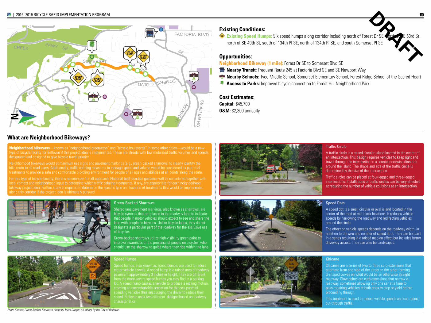
Photo Source: Green-Backed Sharrows photo by Mark Dreger; all others by the City of Bellevue
DR
IVE
DR
IVEPARKWAY
SOMERSET
CREEK
BLVD
SE NEWPORT
DR SE
FOREST HIG
HLAN
D
SE
129TH
PKWY SE
FACTORIA BLVD SE
SOMERSET
ST
SE ALLEN R
D
SPEEDBUMP SPEED
BUMP
SPEEDBUMP SPEED
BUMP
A2T Access to Transit
N
DRAFT
Speed Humps
Speed humps, also known as speed bumps, are used to reduce motor vehicle speeds. A speed hump is a raised area of roadway pavement approximately 3 inches in height. They are different from the more severe speed humps you may find in a parking lot. A speed hump causes a vehicle to produce a rocking motion, creating an uncomfortable sensation for the occupants of speeding vehicles thus encouraging the driver to reduce their speed. Bellevue uses two different designs based on roadway characteristics.
Neighborhood bikeways—known as “neighborhood greenways” and “bicycle boulevards” in some other cities—would be a new type of bicycle facility for Bellevue if this project idea is implemented. These are streets with low motorized traffic volumes and speeds, designated and designed to give bicycle travel priority.
Neighborhood bikeways would at minimum use signs and pavement markings (e.g., green-backed sharrows) to clearly identify the bike route to all road users. Additionally, traffic calming measures to manage speed and volume would be considered as potential treatments to provide a safe and comfortable bicycling environment for people of all ages and abilities at all points along the route.
For this type of bicycle facility, there is no one-size-fits-all approach. National best-practice guidance will be considered together with local context and neighborhood input to determine which traffic calming treatments, if any, are appropriate for each neighborhood bikeway project idea. Further study is required to determine the specific type and location of treatments that would be implemented along this corridor if the project idea is ultimately pursued.
What are Neighborhood Bikeways?
green-Backed Sharrows
Shared lane pavement markings, also known as sharrows, are bicycle symbols that are placed in the roadway lane to indicate that people in motor vehicles should expect to see and share the lane with people on bicycles. Unlike bicycle lanes, they do not designate a particular part of the roadway for the exclusive use of bicycles.
Green-backed sharrows utilize high-visibility green paint to improve awareness of the presence of people on bicycles, who should use the sharrow to guide where they ride within the lane.
Traffic Circle
A traffic circle is a raised circular island located in the center of an intersection. This design requires vehicles to keep right and travel through the intersection in a counterclockwise direction around the island. The shape and size of the traffic circle is determined by the size of the intersection.
Traffic circles can be placed at four-legged and three-legged intersections. Installations of traffic circles can be very effective at reducing the number of vehicle collisions at an intersection.
Speed Dots
A speed dot is a small circular or oval island located in the center of the road at mid-block locations. It reduces vehicle speeds by narrowing the roadway and redirecting vehicles around the circle.
The effect on vehicle speeds depends on the roadway width, in addition to the size and number of speed dots. They can be used in a series resulting in a raised median effect but includes better driveway access. They can also be landscaped.
Chicane
Chicanes are a series of two to three curb extensions that alternate from one side of the street to the other forming S-shaped curves on what would be an otherwise straight roadway. Slow points are curb extensions that narrow a roadway, sometimes allowing only one car at a time to pass requiring vehicles at both ends to stop or yield before proceeding through.
This treatment is used to reduce vehicle speeds and can reduce cut-through traffic.
Existing Conditions:Existing Speed humps: Six speed humps along corridor including north of Forest Dr SE, north of SE 53rd St, north of SE 49th St, south of 134th Pl SE, north of 134th Pl SE, and south Somerset Pl SE
Opportunities:Neighborhood Bikeway (1 mile): Forest Dr SE to Somerset Blvd SE
Nearby Transit: Frequent Route 245 at Factoria Blvd SE and SE Newport WayNearby Schools: Tyee Middle School, Somerset Elementary School, Forest Ridge School of the Sacred HeartAccess to Parks: Improved bicycle connection to Forest Hill Neighborhood Park
Cost Estimates:Capital: $45,700O&M: $2,300 annually
A2T Access to Transit
SPEEDBUMP
110IMPLEMENTATION INITIATIVE_|_2016–2019 BICYCLE RAPID IMPLEMENTATION PROGRAM
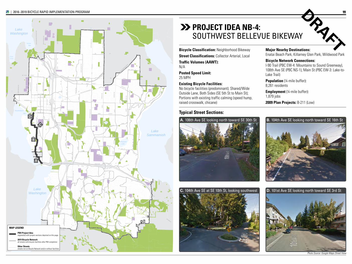
Photo Source: Google Maps Street View
Lake
LakeBellevue
LakeLarsen
Lake
Boren
Phantom
Yarrow
CozyCove
Bay
Bay
Meydenbauer
ClydeLoch
SwanLake
WashingtonLake
SammamishLake
WashingtonLake
NE 2ND ST
106T
H A
V N
E
RED
SE
66
NE
ST
BLVD
SE 8TH ST
130T
H A
V N
E ROAD
132N
D
AV
NE
164T
HAV
SE
173R
DN
E
104T
H A
V S
E
STREET
108T
H
AVE
S
E
STREETNE
123R
D
A
V
S
E
KAMBER
168T
H
AV
S
E
DRIVE
SE
116T
H
AV
S
E
SE
148T
H
AV
DRIVE
ST
PKW
Y
116T
H
STREET
AVE
NU
E N
E
SE 60TH ST
SE 62ND PL
PARKW
AY
100T
H A
VE
NU
E N
E
92N
D A
VE
NU
E N
E
156T
H
SOM
ERSET
150T
H
AV
S
E
161S
T
NE 4TH ST
NE 10TH ST
NE 30TH ST
WAY
LAKE
MO
NT
BLVD
SE
BLVD
CO
AL
CR
EEK
10
OLD BELRD
SE
AV
67
SE 46
SE
118T
H
A
V
S
E
LAKEMO
NT BLVD
SE
SE
120T
H A
V N
E
SE 36TH ST
NE 14 ST
NE 8TH ST
RO
AD
RO
AD
PY
AV
AV
112T
H
AV
S
E
60TH
BLVD SE
NEWPORT
DR
SE
166TH WY SE
W LAKE
NEWCASTLE WAY
SE 34TH ST
BELLEVUE
NE
WAY14
0TH
AV
EN
UE
NE
148T
H A
VE
NU
E N
E
116T
H A
VE
SE
LK W
ASH
BLVD
SE
SE 22ND ST
SE
W L
AKE
BELLEVUE-R
EDMOND ROAD
LAKE WASHINGTON BLVD NE
63RD
EASTGATESE
SE
NE 12TH ST
116T
H
AV
N
E
46THSE
SE
114TH AV SE
PL SE
110T
H A
V N
E
128
SE WAY
NE 20TH STREET
NE 8TH STREET
8THSE
HILLS
LAKE
120T
H
124T
H
AV
N
E
AV
128T
H
AV
S
E
SE 16TH STSA
MM
AMIS
H
FOREST
160T
H AV
E SE
124T
H
AV
SE
HIGHLAND
VILLAGE
WAY
PARK DR SE
SE 26
ST40THNE
NEWCASTLE GOLF CLUB RD
NE 24TH STREET
140T
H A
VE
NU
E N
E
MAIN
164T
HAV
EN
UE
NE
NORTHUP
134T
H A
VE
NU
E N
E
COAL CREEK
NE NORTHUP W
AY
SEST
SE
WAY
164T
H
AV
SE
RICH
ARDS
NE 8TH ST
116T
H A
VE
NU
E N
E
WAY
152N
DSE
AV
NEWPORT
123R
D A
V S
E
LKW
ASH
129TH
PKW
Y
SE
NE
PL
MT
24TH
AV
NE
BELLEVUE-REDMOND
WAY
24TH
112T
H A
VE
SE
BE
LLE
VU
E W
AY
SE 24TH ST
SE
150T
H A
V S
E
119T
H
FAC
TOR
IA B
LVD
SE
NE
SAMMAMISH
Lake Hills Connector
145TH PL SE
156T
H
AVE
NU
E
AVE
NU
E N
E
108T
H A
VE
NU
E N
E
132N
D A
VE
NU
E N
E
LAK
E W
AS
HIN
GTO
N B
LVD
NE
COUGAR
AVE
NU
E
148T
H
MAIN STREET
108T
H A
VE
NU
E N
E
112T
H A
VE
NU
E N
E
SO
ME
RS
ET
ST
BE
LLE
VU
E W
AY
A
D
B
C
D. 101st Ave SE looking north toward SE 3rd StC. 104th Ave SE at SE 10th St, looking southwest
B. 104th Ave SE looking north toward SE 16th StA. 106th Ave SE looking north toward SE 30th St
Typical Street Sections:
DRAFTMajor Nearby Destinations: Enatai Beach Park, Killarney Glen Park, Wildwood Park
Bicycle Network Connections: I-90 Trail (PBC EW-4: Mountains to Sound Greenway), 108th Ave SE (PBC NS-1), Main St (PBC EW-3: Lake-to-Lake Trail)
Population (¼-mile buffer): 8,261 residents
Employment (¼-mile buffer): 1,879 jobs
2009 Plan Projects: B-211 (Low)
Bicycle Classification: Neighborhood Bikeway
Street Classifications: Collector Arterial, Local
Traffic Volumes (AAWT): N/A
Posted Speed Limit: 25 MPH
Existing Bicycle Facilities: No bicycle facilities (predominant); Shared/Wide Outside Lane, Both Sides (SE 5th St to Main St); Portions with existing traffic calming (speed hump, raised crosswalk, chicane)
PROjECT IDEA NB-4:SOuTHWEST BELLEVuE BikEWAY
111IMPLEMENTATION INITIATIVE_|_2016–2019 BICYCLE RAPID IMPLEMENTATION PROGRAM
PBII Project Ideasegment(s) with project sections depicted on this page
2019 Bicycle Networkall streets with bicycle facilities after PBII completion
Other Streetsstreets not on Bicycle Network and/or without facilities
MAP LEGEND
Priority Bicycle Corridorsegment(s) with project sections depicted on this page
Priority Bicycle Corridorremainder of corridor
Planned ConnectionsBicycle facilities along Priority Bicycle Corridors
Nominal AccommodationsUnmarked shared roadways along Cross-City Corridors
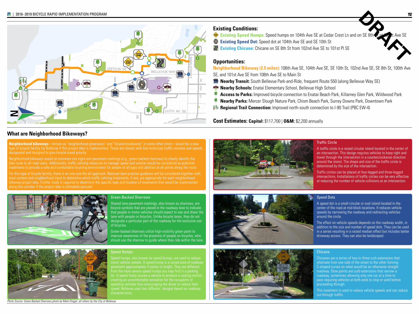
Photo Source: Green-Backed Sharrows photo by Mark Dreger; all others by the City of Bellevue
Bay
Meydenbauer
NE
2ND
ST
104TH AV SE
108TH AV SE
SE
BELLEVUE
LAKE WASHINGTON BLVD NE
114TH AV SE
SE
WAY
112TH AV SE
BELLEVUE WAY
MA
IN S
TRE
ET
SPEEDBUMP
SPEEDBUMP
A2T Access to Transit
A2T Access to Transit
A2T Access to Transit
A2T Access to Transit
N
DRAFT
Speed Humps
Speed humps, also known as speed bumps, are used to reduce motor vehicle speeds. A speed hump is a raised area of roadway pavement approximately 3 inches in height. They are different from the more severe speed humps you may find in a parking lot. A speed hump causes a vehicle to produce a rocking motion, creating an uncomfortable sensation for the occupants of speeding vehicles thus encouraging the driver to reduce their speed. Bellevue uses two different designs based on roadway characteristics.
Neighborhood bikeways—known as “neighborhood greenways” and “bicycle boulevards” in some other cities—would be a new type of bicycle facility for Bellevue if this project idea is implemented. These are streets with low motorized traffic volumes and speeds, designated and designed to give bicycle travel priority.
Neighborhood bikeways would at minimum use signs and pavement markings (e.g., green-backed sharrows) to clearly identify the bike route to all road users. Additionally, traffic calming measures to manage speed and volume would be considered as potential treatments to provide a safe and comfortable bicycling environment for people of all ages and abilities at all points along the route.
For this type of bicycle facility, there is no one-size-fits-all approach. National best-practice guidance will be considered together with local context and neighborhood input to determine which traffic calming treatments, if any, are appropriate for each neighborhood bikeway project idea. Further study is required to determine the specific type and location of treatments that would be implemented along this corridor if the project idea is ultimately pursued.
What are Neighborhood Bikeways?
green-Backed Sharrows
Shared lane pavement markings, also known as sharrows, are bicycle symbols that are placed in the roadway lane to indicate that people in motor vehicles should expect to see and share the lane with people on bicycles. Unlike bicycle lanes, they do not designate a particular part of the roadway for the exclusive use of bicycles.
Green-backed sharrows utilize high-visibility green paint to improve awareness of the presence of people on bicycles, who should use the sharrow to guide where they ride within the lane.
Traffic Circle
A traffic circle is a raised circular island located in the center of an intersection. This design requires vehicles to keep right and travel through the intersection in a counterclockwise direction around the island. The shape and size of the traffic circle is determined by the size of the intersection.
Traffic circles can be placed at four-legged and three-legged intersections. Installations of traffic circles can be very effective at reducing the number of vehicle collisions at an intersection.
Speed Dots
A speed dot is a small circular or oval island located in the center of the road at mid-block locations. It reduces vehicle speeds by narrowing the roadway and redirecting vehicles around the circle.
The effect on vehicle speeds depends on the roadway width, in addition to the size and number of speed dots. They can be used in a series resulting in a raised median effect but includes better driveway access. They can also be landscaped.
Chicane
Chicanes are a series of two to three curb extensions that alternate from one side of the street to the other forming S-shaped curves on what would be an otherwise straight roadway. Slow points are curb extensions that narrow a roadway, sometimes allowing only one car at a time to pass requiring vehicles at both ends to stop or yield before proceeding through.
This treatment is used to reduce vehicle speeds and can reduce cut-through traffic.
Existing Conditions:Existing Speed humps: Speed humps on 104th Ave SE at Cedar Crest Ln and on SE 8th St at 101st Ave SEExisting Speed Dot: Speed dot at 104th Ave SE and SE 10th StExisting Chicane: Chicane on SE 8th St from 102nd Ave SE to 101st Pl SE
Opportunities:Neighborhood Bikeway (2.5 miles): 106th Ave SE, 104th Ave SE, SE 10th St, 102nd Ave SE, SE 8th St, 100th AveSE, and 101st Ave SE from 108th Ave SE to Main St
Nearby Transit: South Bellevue Park-and-Ride, frequent Route 550 (along Bellevue Way SE)Nearby Schools: Enatai Elementary School, Bellevue High SchoolAccess to Parks: Improved bicycle connection to Enatai Beach Park, Killarney Glen Park, Wildwood ParkNearby Parks: Mercer Slough Nature Park, Chism Beach Park, Surrey Downs Park, Downtown ParkRegional Trail Connection: Improved north-south connection to I-90 Trail (PBC EW-4)
Cost Estimates: Capital: $117,700 | O&M: $2,200 annually
A2T Access to Transit
SPEEDBUMP
112IMPLEMENTATION INITIATIVE_|_2016–2019 BICYCLE RAPID IMPLEMENTATION PROGRAM