sweetland wind farm project...sweetland wind farm draft ea introduction western area power...
TRANSCRIPT

Sweetland Wind Farm Project
Draft Environmental Assessment
Hand County, South Dakota
DOE/EA-2095
November 2019

Sw eetland Wind Farm Draft EA Table of Contents
Western Area Pow er Administration TOC-1
TABLE OF CONTENTS
1.0 INTRODUCTION .................................................................................................... 1-1 1.1 Purpose and Need for Federal Action...............................................................1-1 1.2 Sweetland’s Goals and Objectives ...................................................................1-3
2.0 DESCRIPTION OF PROPOSED ACTION AND NO ACTION ALTERNATIVES .................................................................................................... 2-1 2.1 Proposed Action..............................................................................................2-1
2.1.1 Wind Turbines ..................................................................................2-1 2.1.2 Access Roads and Crane Paths ..........................................................2-6 2.1.3 O&M Facility / Temporary Laydown Yard ........................................2-6 2.1.4 Meteorological Towers......................................................................2-7 2.1.5 Underground Collection Lines ...........................................................2-7 2.1.6 Project Substation .............................................................................2-8 2.1.7 Gen-tie Line......................................................................................2-8 2.1.8 Switchyard........................................................................................2-9 2.1.9 Project Life Cycle and Decommissioning...........................................2-9
2.2 No Action Alternative .....................................................................................2-9 3.0 EVALUATION OF ENVIRONMENT IMPACTS.................................................... 3-1
3.1 Geology, Soil Resources, and Paleontology .....................................................3-1 3.1.1 Environmental Consequences: Proposed Action .................................3-2 3.1.2 Environmental Consequences: No Action Alternative ........................3-4
3.2 Water Resources .............................................................................................3-4 3.2.1 Environmental Consequences: Proposed Action .................................3-6 3.2.2 Environmental Consequences: No Action Alternative ........................3-8
3.3 Air Quality .....................................................................................................3-9 3.3.1 Environmental Consequences: Proposed Action .................................3-9 3.3.2 Environmental Consequences: No Action Alternative ...................... 3-11
3.4 Noise ............................................................................................................ 3-11 3.4.1 Environmental Consequences: Proposed Action ............................... 3-12 3.4.2 Environmental Consequences: No Action Alternative ...................... 3-14
3.5 Vegetation .................................................................................................... 3-16 3.5.1 Environmental Consequences: Proposed Action ............................... 3-20 3.5.2 Environmental Consequences: No Action Alternative ...................... 3-23
3.6 Wildlife ........................................................................................................ 3-23 3.6.1 Environmental Consequences: Proposed Action ............................... 3-27 3.6.2 Environmental Consequences: No Action Alternative ...................... 3-31
3.7 Threatened and Endangered Species .............................................................. 3-31 3.7.1 Environmental Consequences: Proposed Action ............................... 3-35 3.7.2 Environmental Consequences: No Action Alternative ...................... 3-38
3.8 Visual Resources .......................................................................................... 3-38 3.8.1 Environmental Consequences: Proposed Action ............................... 3-39 3.8.2 Environmental Consequences: No Action Alternative ...................... 3-44
3.9 Cultural Resources ........................................................................................ 3-44 3.9.1 Environmental Consequences: Proposed Action ............................... 3-47 3.9.2 Environmental Consequences: No Action Alternative ...................... 3-49

Sw eetland Wind Farm Draft EA Table of Contents
Western Area Pow er Administration TOC-2
3.10 Land Use & Public Facilities ......................................................................... 3-49 3.10.1 Environmental Consequences: Proposed Action ............................... 3-50 3.10.2 Environmental Consequences: No Action Alternative ...................... 3-52
3.11 Socioeconomics ............................................................................................ 3-52 3.11.1 Environmental Consequences: Proposed Action ............................... 3-53 3.11.2 Environmental Consequences: No Action Alternative ...................... 3-55
3.12 Environmental Justice ................................................................................... 3-56 3.12.1 Environmental Consequences: Proposed Action ............................... 3-57 3.12.2 Environmental Consequences: No Action Alternative ...................... 3-57
3.13 Health and Safety .......................................................................................... 3-57 3.13.1 Environmental Consequences: Proposed Action ............................... 3-59 3.13.2 Environmental Consequences: No Action Alternative ...................... 3-62
4.0 CUMULATIVE IMPACTS ...................................................................................... 4-1 5.0 COORDINATION.................................................................................................... 5-1
5.1 Federal Agencies ............................................................................................5-1 5.2 State and Local Agencies ................................................................................5-1 5.3 Native American Tribes and Associated Bodies ...............................................5-2 5.4 Non-Governmental Organizations ...................................................................5-2
6.0 LIST OF PREPARERS .......................................................................................... 6-1 7.0 REFERENCES ....................................................................................................... 7-1
APPENDIX A – WIND TURBINE AND TRANSMISSION FACILITY DIAGRAMS APPENDIX B – WETLAND DELINEATION REPORT APPENDIX C – HAND COUNTY DEVELOPMENT AGREEMENT APPENDIX D – SOUND STUDY APPENDIX E – NATIVE GRASSLANDS HABITAT REPORT APPENDIX F – EAGLE AND RAPTOR NEST SURVEYS APPENDIX G – AVIAN USE SURVEYS APPENDIX H – ACOUSTIC BAT SURVEYS APPENDIX I – BIRD AND BAT CONSERVATION STRATEGY APPENDIX J – PRESENCE/ABSENCE SURVEYS FOR NORTHERN LONG-EARED
BAT APPENDIX K – WHOOPING CRANE HABITAT REVIEW APPENDIX L – CONSISTENCY EVALUATION FORMS APPENDIX M – WHOOPING CRANE MONITORING PLAN AND SHUT-DOWN
PROTOCOL APPENDIX N – SHADOW FLICKER REPORT APPENDIX O – CULTURAL RESOURCES REPORTS APPENDIX P – SCOPING MEETING INFORMATION APPENDIX Q – AGENCY CORRESPONDENCE AND PUBLIC COMMENTS

Sw eetland Wind Farm Draft EA Table of Contents
Western Area Pow er Administration TOC-3
TABLES Table 2-1: Estimated Project Footprint ...............................................................................2-3 Table 2-2: Turbine Options ................................................................................................2-5 Table 2-3: Sweetland Wind Farm Siting Requirements .......................................................2-5 Table 3-1: Farmland Types Within the Project Area............................................................3-1 Table 3-2: Wetlands and Streams .......................................................................................3-6 Table 3-3: Typical Sound Pressure Levels Associated with Common Noise Sources .......... 3-11 Table 3-4: Land Cover Types Within the Project Area ...................................................... 3-16 Table 3-5: State and Local Noxious Weeds of South Dakota ............................................. 3-19 Table 3-6: Sweetland Wind Farm Wildlife Studies............................................................ 3-23 Table 3-7: Federally Listed Terrestrial Species Potentially Occurring in Study Area .......... 3-31 Table 3-8: Project Area Roads.......................................................................................... 3-50 Table 3-9: Key Measures of Economic Development ........................................................ 3-52 Table 3-10: Direct Economic Benefit from the Sweetland Wind Farm ................................. 3-53 Table 3-11: Anticipated Construction Jobs and Employment Expenditures .......................... 3-54 Table 3-12: Anticipated Operation Jobs and Employment Expenditures .............................. 3-55 Table 3-13: Minority and Low-Income Populations (2013-2017)......................................... 3-56 Table 3-14: Example EMF Levels with Increasing Distance from a Power
Transmission Line ........................................................................................... 3-60 Table 3-15: EMF Levels of Common Household Appliances .............................................. 3-60 Table 4-1: Discussion of Cumulative Effects ......................................................................4-2 Table 6-1: List of EA Preparers ..........................................................................................6-1
FIGURES Figure 1-1: Project Location ................................................................................................1-2 Figure 2-1: Project Layout...................................................................................................2-2 Figure 3-1: Water Resources ...............................................................................................3-5 Figure 3-2: Sound Level Modeling Results ........................................................................ 3-15 Figure 3-3: Land Cover ..................................................................................................... 3-17 Figure 3-4: Public Lands and Conservation Easements ....................................................... 3-18 Figure 3-5: Whooping Crane Migration Corridor ............................................................... 3-34 Figure 3-6: Whooping Crane Stopover Habitat................................................................... 3-36

Sw eetland Wind Farm Draft EA List of Abbreviations
Western Area Pow er Administration i
List of Abbreviations
Abbreviation Term/Phrase/Name
ADLS aircraft detection lighting systems
APE Area of Potential Effects
APLIC Avian Power Line Interaction Committee
BBCS Bird and Bat Conservation Strategy
BCC Bird of Conservations Concern
BMP best management practices
Burns & McDonnell Burns & McDonnell Engineering Company, Inc.
CEQ Council on Environmental Quality
CWCTP Cooperative Whooping Crane Tracking Project
dBA A-weighted decibels
EA Environmental Assessment
EMF electric and magnetic field
EPA U.S. Environmental Protection Agency
FAA Federal Aviation Administration
FEMA Federal Emergency Management Agency
GE General Electric
gen-tie generation-tie
GHG greenhouse gases
ICNIRP International Commission on Non-ionizing Radiation Protection
IEEE Institute of Electrical and Electronics Engineers
IPaC Information for Planning and Consultation

Sw eetland Wind Farm Draft EA List of Abbreviations
Western Area Pow er Administration ii
Abbreviation Term/Phrase/Name
kV kilovolt
mG milliGauss
MW megawatt
NAAQS National Ambient Air Quality Standards
NEPA National Environmental Policy Act
NHPA National Historic Preservation Act
NIEHS National Institute of Environmental Health Sciences
NRCS Natural Resource Conservation Service
NRHP National Register of Historic Places
O&M operations and maintenance
PEIS Programmatic Environmental Impact Statement
PFYC Potential Fossil Yield Classification
Project Sweetland Wind Farm Project
Project Area 21,006-acre area southeast of City of Miller in Hand County, SD
SDDENR South Dakota Department of Environment and Natural Resources
SDDOA South Dakota Department of Agriculture
SDDOT South Dakota Department of Transportation
SDGFP South Dakota Game, Fish and Parks
SDPUC South Dakota Public Utilities Commission
SHPO State Historic Preservation Office
SPCC Spill Prevention, Control and Countermeasure
SPP Southwest Power Pool

Sw eetland Wind Farm Draft EA List of Abbreviations
Western Area Pow er Administration iii
Abbreviation Term/Phrase/Name
Sweetland Sweetland Wind Farm, LLC
SWPPP Storm Water Pollution Prevention Plan
TCP traditional cultural property
UGP Upper Great Plains
USACE U.S. Army Corps of Engineers
USFWS U.S. Fish and Wildlife Service
USGS U.S. Geological Survey
VOC volatile organic compounds
WAPA Western Area Power Administration

Sw eetland Wind Farm Draft EA Introduction
Western Area Pow er Administration 1-1
1.0 INTRODUCTION
Sweetland Wind Farm, LLC (Sweetland) proposes to construct the Sweetland Wind Farm Project
(Project), an approximately 200-megawatt (MW) wind farm. The Project would be located within a 21,006-acre area (Project Area) southeast of the City of Miller in Hand County, South Dakota (Figure
1-1).
Project components would include:
• Up to 71 wind turbines;
• Access roads to each wind turbine;
• An operations and maintenance (O&M) facility;
• Up to three permanent meteorological towers;
• Underground power collection lines and communications system;
• A substation;
• An up to 7-mile-long, 230-kV transmission line (gen-tie line);
• A switchyard; and
• Additional temporary construction areas, including crane paths, pull sites, access roads, and a
laydown yard (a concrete batch plant would be located in the laydown yard or offsite).
If constructed, the Project would interconnect with Western Area Power Administration’s (WAPA’s) existing Fort Thompson to Huron 230-kV transmission line.
This Environmental Assessment (EA) analyzes and discloses potential impacts associated with the
proposed Project. The EA tiers off the analysis conducted in the Upper Great Plains (UGP) Wind Energy Final Programmatic Environmental Impact Statement (PEIS), a document prepared jointly by WAPA and
the U.S. Fish and Wildlife Service (USFWS) (WAPA and USFWS, 2015a).
1.1 Purpose and Need for Federal Action WAPA must consider and respond to Sweetland’s interconnection request in accordance with the Southwest Power Pool (SPP) Tariff and the Federal Power Act, as described in Section 1.1.1 of the PEIS.

Sw eetland Wind Farm Draft EA Introduction
Western Area Pow er Administration 1-2
Figure 1-1: Project Location

Sw eetland Wind Farm Draft EA Introduction
Western Area Pow er Administration 1-3
1.2 Sweetland’s Goals and Objectives Sweetland’s goals and objectives for the proposed Project are to provide a reliable and cost-effective
source of renewable energy to energy users. To accomplish this purpose, the Project must be technically, environmentally, and economically feasible. To that end, Sweetland needs the following factors to be
present:
• A reliable wind resource,
• Landowners willing to participate in the Project,
• Ecological conditions that allow the Project to comply with applicable environmental regulations
at a reasonable cost,
• A generator interconnection agreement with WAPA and SPP to transmit power to a power purchaser, and
• A customer to purchase the power that is generated by the Project.

Sw eetland Wind Farm Draft EA Description of Proposed Action and No Action Alternatives
Western Area Pow er Administration 2-1
2.0 DESCRIPTION OF PROPOSED ACTION AND NO ACTION ALTERNATIVES
This EA analyzes two alternatives, the Proposed Action and the No Action Alternative.
2.1 Proposed Action The Proposed Action is for Sweetland to:
1. Construct and operate the Project,
2. Enter into a generator interconnection agreement with WAPA and SPP to connect the Project to
WAPA’s existing Fort Thompson to Huron 230-kV transmission line.
Figure 2-1 shows the proposed preliminary layout of the Project facilities. Project facilities were sited to
avoid or reduce potential cultural and tribal, wetland, avian, visual resource, sound, and other impacts to
the greatest extent possible while still keeping the Project viable. Shifts in Project facilities may be necessary as a result of geotechnical evaluations, landowner input, or to avoid newly identified cultural or
tribal resources. If shifts become necessary, Sweetland would notify WAPA of these shifts, in order to
determine whether additional analysis is necessary.
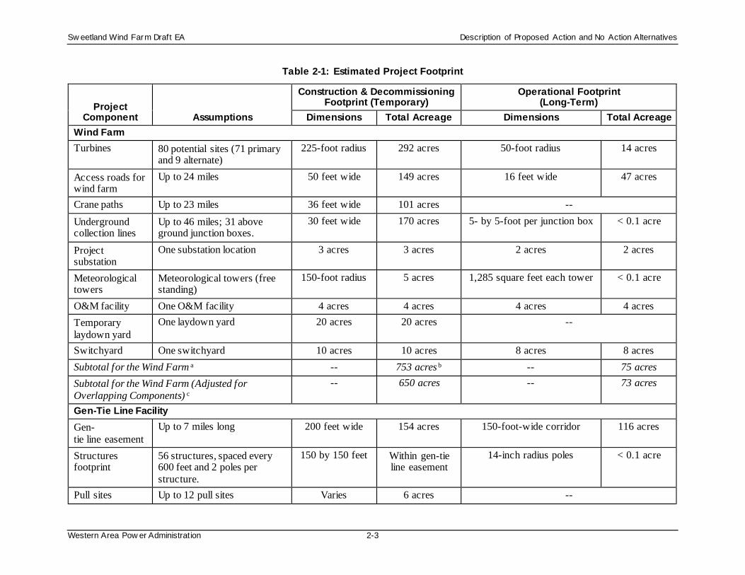
Table 2-1 summarizes the temporary and long-term footprint of each Project component. Construction activities would last about 12 months, and decommissioning would last about 6 months. Project operation
would continue for approximately 35 years. Construction and maintenance activities would occur
annually, primarily April to November or when weather conditions allow.
2.1.1 Wind Turbines Sweetland plans to install up to 71 wind turbines for the Project. Figure 2-1 shows the preliminary
locations for the 71 primary wind turbine and 9 alternate locations. For analysis purposes, the EA
discusses the impacts of all 80 potential turbine locations, even though only 71 would be constructed.
During construction, roughly 3.6 acres per turbine would be needed to stage the wind turbine parts and to maneuver equipment during turbine assembly (see Section 3.3 in the PEIS). Each turbine would sit on a
permanent concrete foundation, also known as a turbine pad, to provide structural support to the
assembled turbine. Each turbine pad would measure approximately 0.05 acre. Except for roughly 2.5 feet that would remain aboveground, the tower foundation would extend approximately 8 feet underground.
The towers would be painted a non-glare white per Federal Aviation Administration (FAA) requirements.

Sw eetland Wind Farm Draft EA Description of Proposed Action and No Action Alternatives
Western Area Pow er Administration 2-2
Figure 2-1: Project Layout
Sw eetland Wind Farm Draft EA Description of Proposed Action and No Action Alternatives
Western Area Pow er Administration 2-3
Table 2-1: Estimated Project Footprint
Project Component Assumptions
Construction & Decommissioning Footprint (Temporary)
Operational Footprint (Long-Term)
Dimensions Total Acreage Dimensions Total Acreage Wind Farm Turbines 80 potential sites (71 primary
and 9 alternate) 225-foot radius 292 acres 50-foot radius 14 acres
Access roads for wind farm
Up to 24 miles 50 feet wide 149 acres 16 feet wide 47 acres
Crane paths Up to 23 miles 36 feet wide 101 acres -- Underground collection lines
Up to 46 miles; 31 above ground junction boxes.
30 feet wide 170 acres 5- by 5-foot per junction box < 0.1 acre
Project substation
One substation location 3 acres 3 acres 2 acres 2 acres
Meteorological towers
Meteorological towers (free standing)
150-foot radius 5 acres 1,285 square feet each tower < 0.1 acre
O&M facility One O&M facility 4 acres 4 acres 4 acres 4 acres Temporary laydown yard
One laydown yard 20 acres 20 acres --
Switchyard One switchyard 10 acres 10 acres 8 acres 8 acres Subtotal for the Wind Farm a -- 753 acres b -- 75 acres Subtotal for the Wind Farm (Adjusted for Overlapping Components) c
-- 650 acres -- 73 acres
Gen-Tie Line Facility Gen-tie line easement
Up to 7 miles long 200 feet wide 154 acres 150-foot-wide corridor 116 acres
Structures footprint
56 structures, spaced every 600 feet and 2 poles per structure.
150 by 150 feet Within gen-tie line easement
14-inch radius poles < 0.1 acre
Pull sites Up to 12 pull sites Varies 6 acres --

Sw eetland Wind Farm Draft EA Description of Proposed Action and No Action Alternatives
Western Area Pow er Administration 2-4
Project Component Assumptions
Construction & Decommissioning Footprint (Temporary)
Operational Footprint (Long-Term)
Dimensions Total Acreage Dimensions Total Acreage Subtotal Gen-Tie Line Facility a -- 160 acres b -- < 0.1 acre Subtotal Gen-Tie Line Facility(Adjusted for Overlapping Components) c
-- 160 acres -- < 0.1 acre
Project Totals Construction/Decommissioning 914 acres Operation 75 acres Construction/Decommissioning (Adjusted for
Overlapping Components) c 810 acres Operation (Adjusted for
Overlapping Components) c 73 acres
(a) This subtotal is a sum of each Project component’s footprint. Some components will overlap. This subtotal has not been adjusted for these overlapping components. Therefore, this subtotal overstates the Project disturbance. (b) The sum of individual components does not exactly match the subtotal due to rounding. (c) This subtotal has been adjusted to account for overlapping footprints.
Sw eetland Wind Farm Draft EA Description of Proposed Action and No Action Alternatives
Western Area Pow er Administration 2-5
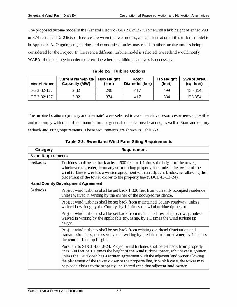
The proposed turbine model is the General Electric (GE) 2.82/127 turbine with a hub height of either 290
or 374 feet. Table 2-2 lists differences between the two models, and an illustration of this turbine model is in Appendix A. Ongoing engineering and economics studies may result in other turbine models being
considered for the Project. In the event a different turbine model is selected, Sweetland would notify
WAPA of this change in order to determine whether additional analysis is necessary.
Table 2-2: Turbine Options
Model Name Current Nameplate
Capacity (MW) Hub Height
(feet) Rotor
Diameter (feet) Tip Height
(feet) Swept Area
(sq. feet) GE 2.82/127 2.82 290 417 499 136,354 GE 2.82/127 2.82 374 417 584 136,354
The turbine locations (primary and alternate) were selected to avoid sensitive resources wherever possible and to comply with the turbine manufacturer’s general setback considerations, as well as State and county
setback and siting requirements. These requirements are shown in Table 2-3.
Table 2-3: Sweetland Wind Farm Siting Requirements
Category Requirement State Requirements Setbacks Turbines shall be set back at least 500 feet or 1.1 times the height of the tower,
whichever is greater, from any surrounding property line, unless the owner of the wind turbine tower has a written agreement with an adjacent landowner allowing the placement of the tower closer to the property line (SDCL 43-13-24).
Hand County Development Agreement Setbacks Project wind turbines shall be set back 1,320 feet from currently occupied residence,
unless waived in writing by the owner of the occupied residence. Project wind turbines shall be set back from maintained County roadway, unless waived in writing by the County, by 1.1 times the wind turbine tip height. Project wind turbines shall be set back from maintained township roadway, unless waived in writing by the applicable township, by 1.1 times the wind turbine tip height. Project wind turbines shall be set back from existing overhead distribution and transmission lines, unless waived in writing by the infrastructure owner, by 1.1 times the wind turbine tip height. Pursuant to SDCL 43-13-24, Project wind turbines shall be set back from property lines 500 feet or 1.1 times the height of the wind turbine tower, whichever is greater, unless the Developer has a written agreement with the adjacent landowner allowing the placement of the tower closer to the property line, in which case, the tower may be placed closer to the property line shared with that adjacent land owner.

Sw eetland Wind Farm Draft EA Description of Proposed Action and No Action Alternatives
Western Area Pow er Administration 2-6
Category Requirement Noise Sound levels resulting from Project wind turbines will not exceed 50 dBA at the
currently occupied residences of participating landowners and 45 dBA at the currently occupied residences of non-participating landowners, unless waived in writing by the owner of the occupied residence.
Shadow Flicker Limit shadow flicker resulting from Project wind turbines at currently occupied residences to 30 hours per year or less, unless waived in writing by the owner of the occupied residence.
Source: Hand County Development Agreement, 2018
2.1.2 Access Roads and Crane Paths Existing public roads, private roads, and field paths would be used whenever possible. The existing roads
may require improvements before, during, or following construction. Improvements could include adding gravel, widening, or repairing potholes.
Even with the use of existing roads, Sweetland expects that up to 24 miles of new gravel access roads
would be necessary. During construction, the access roads would be maintained at 50 feet wide. After construction, the roads would be maintained at 16 feet wide.
Up to 23 miles of access routes may be required for the cranes used to erect the wind turbines. The crane
paths would be 36 feet wide and would only be needed during construction. Up to 1.2 miles of crane path
would cross USFWS Grassland Easements; however, no grading or other surface disturbance would be required to create the crane paths, and Sweetland would use cranes with inflatables to minimize soil
compaction and soil disturbance, if this crane type is available for use on the Project. The Project would
not create surface disturbance on USFWS Grassland Easements. Crane paths would avoid USFWS Wetland Easements.
2.1.3 O&M Facility / Temporary Laydown Yard An up to 20-acre temporary laydown yard and 4-acre long-term O&M facility would be needed. Two
potential locations for these facilities are being evaluated, as shown on Figure 2-1. The northern location is preferred, but the southern location has also been identified as an alternate. The factors that would
influence the final decision would be transportation logistics and the construction team’s input. The long-
term O&M facility would not necessarily be developed on the same location option as the temporary
laydown yard. Thus, it is possible that both the northern and southern sites would be used for facilities. This EA considers the potential environmental effects of both locations.
Construction tools, materials, equipment, and vehicles, would be stored at the laydown yard until needed
for construction activities. The laydown yard would be revegetated once construction is complete, except

Sw eetland Wind Farm Draft EA Description of Proposed Action and No Action Alternatives
Western Area Pow er Administration 2-7
for a portion retained for the O&M facility (if the laydown yard and O&M facility are sited on the same
location option). The O&M facility would be a single- or two-story building, which would house operating personnel, offices, operations and communication equipment, parts storage and maintenance
activities, and a vehicle parking area. An area for outdoor storage of larger equipment and materials
would also be included within a fenced area for safety and security. The facility would also have running
water, which would be provided by either the existing rural water system or a new private water well.
2.1.4 Meteorological Towers Five temporary meteorological towers are currently on the Project site. Two 60-meter towers were
installed in June 2017. A new 100-meter tower was installed in July 2017. Two additional new 60-meter
towers were installed in August 2018. All of these towers would be removed as part of Project construction.
Up to three permanent meteorological towers would be installed. Figure 2-1 shows the preliminary
locations for permanent meteorological towers. The meteorological towers would be free-standing and a maximum of 374 feet tall. The meteorological towers would be marked and lighted as specified by the
FAA, and the towers would have aircraft detection lighting systems (ADLS), if required by the FAA
and/or the South Dakota Public Utilities Commission (SDPUC).
Construction of the meteorological towers would disturb up to 5 acres (a 150-foot radius area per tower). Operation of the meteorological towers is expected to permanently impact less than 0.1 acre.
2.1.5 Underground Collection Lines The power generated by the wind turbines would be transmitted through underground collection lines to
the Project substation. The collection lines would be a 34.5-kV underground electrical cable system installed approximately 42 inches below the ground. Underground collection lines that cross a USFWS
Wetland Easement would be installed by directional boring beneath the wetland; the remaining
underground collection lines would be installed by trenching. Aboveground junction boxes would be
installed as required for connections or splices, approximately every 8,000 feet. Junction boxes would not be sited on USFWS Wetland or Grassland Easements. Each turbine would be connected to a supervisory
control and data acquisition system via fiber-optic cable, which would be installed in the same trench as
the underground collection lines.
Construction of the underground collection lines would temporarily disturb a 30-foot-wide path for
approximately 46 miles, or 170 acres (assuming construction of all 80 turbine location options). Some of
the construction disturbance for the underground collection system would be shared with construction

Sw eetland Wind Farm Draft EA Description of Proposed Action and No Action Alternatives
Western Area Pow er Administration 2-8
disturbance for other Project facilities where these facilities overlap. The ground surface above the lines
would be revegetated, but no trees would be permitted above the lines. Sweetland estimates that 31 permanent above-ground junction boxes would be needed and the total disturbance would equal less than
0.1 acre.
2.1.6 Project Substation At the Project substation, the electrical voltage would be stepped up from 34.5 kV from the underground collection lines to 230 kV for the Project gen-tie line. Construction of the Project substation would result
in approximately 3 acres of land disturbance. Once operational, the Project substation would be on a
2-acre site and consist of one substation transformer, circuit breakers, switching devices, auxiliary
equipment, a control enclosure (containing equipment for proper control, protection, monitoring, and communications), and other miscellaneous equipment. The entire substation would be fenced for safety
and security. Approval for the Project substation would be subject to Hand County’s Conditional Use
Permit process.
2.1.7 Gen-tie Line The 230-kV gen-tie line would transmit the power from the Project substation to a new switchyard,
located adjacent to WAPA’s existing Fort Thompson to Huron 230-kV transmission line. The gen-tie line
route would travel south from the proposed Project substation to WAPA’s existing Fort Thompson to Huron 230-kV transmission line, then parallel WAPA’s existing transmission line and terminate at the
switchyard (Section 2.1.8). The gen-tie line route would avoid USFWS Wetland Easements and would
span USFWS Grassland Easements (Section 3.5). The gen-tie line route is up to 7 miles long.
The gen-tie line would be a single circuit powerline with either (1) two-pole wooden H-frame structures with a height of approximately 75 feet, or (2) single steel monopole structures with a height of
approximately 110 feet. Fiber optic cable would also be mounted on the structures. The gen-tie line would
be marked with bird diverters that have qualities such as high wind resistance, are visible at a distance,
and adhere to APLIC (2012) recommendations. The markers would be maintained for the life of the Project.
During construction, the easement area would be 200 feet wide (including 50 feet for temporary
construction activities), or 154 acres. Construction of each transmission structure would disturb an approximately 150- by 150-foot area per structure, which would be contained within the easement area.
Sweetland estimates that 12 pull sites may be necessary to string the conductor. These sites would vary in

Sw eetland Wind Farm Draft EA Description of Proposed Action and No Action Alternatives
Western Area Pow er Administration 2-9
size, but are expected to total about 6 acres. After construction, Sweetland would retain a 150-foot wide
easement but intends to restore the easement area to pre-construction land use.
2.1.8 Switchyard The gen-tie line would terminate at a switchyard constructed adjacent to WAPA’s existing Fort
Thompson to Huron 230-kV transmission line. The switchyard would house equipment such as breakers,
relays, communications and control equipment, and aboveground bus structures. Approval for the switchyard would be subject to Hand County’s Conditional Use Permit process. WAPA may construct a
temporary tap at the switchyard location. The temporary tap would be constructed in accordance with a
construction agreement between WAPA and Sweetland. Construction of the temporary tap would enable
the Project to interconnect on WAPA’s existing Fort Thompson to Huron 230 kV transmission line while the switchyard is constructed.
Two switchyard locations (preferred and alternate) are under consideration (Figure 2-1). The preferred
switchyard option would be located at the northwest intersection of 209th Street and 372nd Avenue. The alternate switchyard option would be located on a parcel on the south side of 209th Street, just north of
proposed turbine 79. Construction of either switchyard alternative would result in approximately 10 acres
of land disturbance. Once operational, either switchyard would be on an 8-acre site.
2.1.9 Project Life Cycle and Decommissioning The expected life of the Project is approximately 35 years. This 35-year estimate includes a potential
repower and/or retrofit of the turbines and power system with upgrades based on new technology. Section
3 of the PEIS describes the activities likely to occur during each of the major phases of a typical wind
energy project’s life cycle – site testing and monitoring, construction, operation, maintenance, and decommissioning. The same project phases, with similar types of activities for each phase, would occur
for this Project.
2.2 No Action Alternative Under the No Action Alternative, WAPA would not enter into an interconnection agreement with Sweetland and would not allow the Project to interconnect to the WAPA transmission system. Although
Sweetland could build the Project and pursue an interconnection with a private utility, for comparison,
this alternative assumes that the proposed Project would not be built.

Sw eetland Wind Farm Draft EA Evaluation of Environment Impacts
Western Area Pow er Administration 3-1
3.0 EVALUATION OF ENVIRONMENT IMPACTS
Chapter 5 of the PEIS discusses the potential direct and indirect environmental impacts of wind energy
development across the UGP Region and identified Best Management Practices (BMPs) to minimize impacts. This chapter will focus on site-specific information relevant to this Project. First, the chapter will
describe the existing conditions of various resources within a specified study area. The study area varies
according to resource. Next, the chapter will analyze the anticipated impact of each Alternative on the resource area, and, lastly, list any environmental commitments that would be incorporated to reduce
impacts.
As discussed in Section 2.1, the temporary construction activities would last about 12 months and
decommissioning activities would last about 6 months. Long-term, the Project would operate for approximately 35 years.
3.1 Geology, Soil Resources, and Paleontology The soils within the Project Area primarily consist of fine or fine-loamy soils derived mostly from loamy
till to fine-loamy till, and the underlying Pierre shale bedrock. The soils in the Project Area are not highly susceptible to erosion and are generally good for crop production (Natural Resources Conservation
Service [NRCS], 2018). Most soils in the Project Area are well drained.
Prime farmlands are subject to protection under the Farmland Protection Policy Act. Most of the farmland soil in the Project Area is classified as either “prime farmland if irrigated” or “not prime farmland.” The
remaining farmland is “farmland of statewide importance” with a small amount of “prime farmland.”
None of the prime farmland is currently irrigated. Farmland soil types within the Project Area are shown
in Table 3-1.
Table 3-1: Farmland Types Within the Project Area
Farmland Type Area (acres) Percentage of Project Area
Prime farmland 278 1 Prime farmland if irrigateda 11,846 56 Farmland of statewide importance 2,757 13 Not prime farmland 6,125 29 Total 21,006 100
Source: NRCS, 2018 (a) No prime farmland is currently irrigated in the Project Area

Sw eetland Wind Farm Draft EA Evaluation of Environment Impacts
Western Area Pow er Administration 3-2
The surface geology of the Project Area has been classified and scored by the Potential Fossil Yield
Classification (PFYC) system. The PFYC assigns a numeric score between 1 and 5, with 5 representing the highest potential for fossil materials to be present. Paleontological localities are common in
formations with a PFYC rating of 5. The Project Area is underlain by Pierre Shale bedrock, with a PFYC
rating of 4. The Project Area does not include significant rock outcrops.
No reclaimed or active mines are located within the Project Area. The risk of seismic activity near the Project Area is low and there are no faults within the Project Area (USGS, 2017). Therefore, mineral
resources and seismic risk are not addressed further in this EA.
3.1.1 Environmental Consequences: Proposed Action The following environmental commitments would be implemented:
• Design the Project to avoid steep slope areas and minimize construction cut and fill work.
• Obtain coverage under the General Permit for Storm Water Discharges Associated with
Construction Activities issued by the SDDENR. This permit requires development and implementation of a Storm Water Pollution Prevention Plan (SWPPP). The SWPPP would be
developed during civil engineering design of the Project and would include BMPs to control
erosion and sedimentation.
• Minimize ground-disturbing activities, especially during the rainy season.
• Surface new roads with aggregate materials, wherever appropriate.
• Restrict heavy vehicles and equipment to improved roads to the extent practicable.
• Control vehicle and equipment speed on unpaved surfaces.
• Use cranes with inflatables to minimize soil compaction and soil disturbance, if this crane type is
available for use on the Project.
• Stabilize disturbed areas that are not actively under construction using methods such as erosion
matting or soil aggregation, as site conditions warrant.
• Regularly inspect access roads, utility and transmission line corridors, and tower site areas for
damage from erosion, washouts, and rutting. Initiate corrective measures immediately upon
evidence of damage.
• Strip topsoil from any agricultural area used for traffic or vehicle parking—segregating topsoil
from excavated rock and subsoil and replacing it during restoration activities.
• Correct drainage problems caused by construction, to avoid damage to agricultural fields.
• Following completion of construction and during decommissioning, decompact subsoil.

Sw eetland Wind Farm Draft EA Evaluation of Environment Impacts
Western Area Pow er Administration 3-3
• Salvage topsoil from all excavation and construction activities to reapply to disturbed areas once
construction is completed.
• Dispose of excess excavation materials in approved areas to control erosion.
• Isolate excavation areas (and soil piles) from surface water bodies using silt fencing, bales, or
other accepted appropriate methods to limit sediment transport by surface runoff.
• Use earth dikes, swales, and lined ditches to divert local runoff around the work site.
• Reestablish the original grade and drainage pattern to the extent practicable.
• Remove turbines and ancillary structures from the site during decommissioning.
• Excluding belowground portions of decommissioned turbine foundations intentionally left in place, do not bury or leave in place excess concrete in active agricultural areas.
Construction of the Project would temporarily impact up to 810 acres of soils from road construction,
foundation excavation, trenching for collection lines, and other construction activities. This includes up to
134 acres of farmland of statewide importance. Cranes used for construction of wind turbines would travel along identified crane paths. Sweetland would use cranes with inflatables to minimize soil
compaction and soil disturbance, if this crane type is available for use on the Project. No grading or other
pre-disturbance would be required to create the crane paths. During construction of other project components, existing vegetation would be removed in the areas associated with the proposed Project
components, potentially increasing the risk of erosion because the soils are moderately susceptible to
erosion. Use of heavy equipment would potentially compact soils. Topsoils would be segregated prior to
construction, so construction activities would not mix topsoil and subsoil layers. Following construction, subsoil would be decompacted where needed, salvaged topsoil would be replaced, and the Project Area
would be stabilized either with new surfaces or vegetation.
Ground-disturbing activities during construction could affect paleontological resources. Based on the paleontological resource sensitivity (PFYC 4) of the geologic formations within the Project Area, the risk
for impacts to paleontological resources from the Project is moderate. The construction of the turbine
foundations would have the greatest potential to affect fossil-bearing formations. Foundations for
substation equipment, while not nearly as deep, could also affect fossil-bearing formations at the substation site.
Permanent aboveground facilities (access roads, turbines, either gen-tie line route option, either O&M
facility location, the switchyard, and the Project substation) would permanently impact up to 73 acres of soils. Permanent aboveground facilities would impact up to 10 acres of farmland of statewide importance.

Sw eetland Wind Farm Draft EA Evaluation of Environment Impacts
Western Area Pow er Administration 3-4
During decommissioning, impacts to soils would be similar to those during construction. However,
decommissioning activities would not cause new impacts to paleontological resources because these activities would take place in areas that had already been disturbed by Project construction.
3.1.2 Environmental Consequences: No Action Alternative The No Action Alternative would have no direct or indirect impacts on soil, geology, or paleontological
resources. Existing activities, such as farming and the trend toward conversion of undeveloped land to agriculture, would likely continue. These types of activities can impact soil, geology, or paleontological
resources.
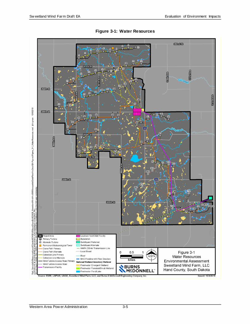
3.2 Water Resources The groundwater system in the region is based on glacial outwash aquifers. The aquifers can vary in depth from 0 to 400 feet (Chadima, 1994). Private wells are used to supply water for domestic and irrigation
purposes. The Mid-Dakota Rural Water System supplies rural water to the area and maintains a network
of underground distribution lines within the Project Area.
The Project Area is located within the Middle James River watershed, which is part of the Missouri River Basin surface water drainage system. Intermittent streams within the Project Area include East Pearl and
Silver Creeks and their tributaries. No perennial streams are within the Project Area (Figure 3-1).
Wetlands and streams were identified using desktop evaluations and field surveys within a study area defined using the following buffers:
• 250 feet surrounding each turbine
• 200 feet surrounding each facility footprint (for example, the substation, meteorological towers,
etc.)
• 100-foot buffer (200 feet wide) for all remaining linear features (such as the gen-tie line, access
roads, crane paths, etc.)
The desktop evaluation used USFWS National Wetlands Inventory data along with soils data, topographic information, and multiple years of aerial imagery. These sources generally identify all areas
that are likely to exhibit wetland characteristics. The entire wetlands study area was evaluated by desktop
in this manner, prior to starting the field surveys. Reference the wetland delineation report for further
description of the study area and methodology for the wetland delineation (Appendix B).
Sw eetland Wind Farm Draft EA Evaluation of Environment Impacts
Western Area Pow er Administration 3-5
Figure 3-1: Water Resources

Sw eetland Wind Farm Draft EA Evaluation of Environment Impacts
Western Area Pow er Administration 3-6
All USFWS Wetland Easements and all wetland areas depicted on maps associated with the USFWS
Wetland Easements were accounted for during the survey. In the few instances where USFWS Wetland Easements were shown in easement maps but there was no indication of the wetlands during field
surveys, the USFWS-depicted wetland areas were still considered present for the purposes of determining
potential wetland impacts.
A total of 78 wetlands and 28 streams were identified within a study area. Table 3-2 summarizes the types and proportions of wetlands identified.
Table 3-2: Wetlands and Streams
Classification Acreage Proportion of Study
Area Palustrine Emergent (PEM) 38.6 1.6% Palustrine Aquatic Bed (PAB) 0.0 0.0% Riverine Intermittent/Ephemeral (R4/R5) 1.5 <0.1% Palustrine Forested (PFO) 0.2 <0.1% Palustrine Unconsolidated Bottom (PUB) 1.0 <0.1% Uplands (UPL) 2,341.7 98.3% Total 2,383 100%
Source: Burns & McDonnell Engineering Company, Inc. (Burns & McDonnell), 2019
Additional surveys were conducted in late September 2019 and an updated wetland delineation report will
be provided in Appendix B as part of the Final EA. Preliminary results indicate that the updated acreage
of wetlands and streams will not exceed what is shown in Table 3-2.
The Project Area also includes prairie potholes, depressions formed by previous glacier activity, which
are common in the Upper Midwest region.
According to the Federal Emergency Management Agency (FEMA) Flood Map Service Center, studies to
determine a flood hazard for Hand County have not been completed and a flood map has not been published at this time (FEMA, 2017). The Hand County Flood Plain Manager indicated the Project Area
is not located in a mapped floodplain. Narrow floodplains exist along intermittent streams, including East
Pearl and Silver Creeks, in southeastern Hand County.
3.2.1 Environmental Consequences: Proposed Action The following environmental commitments would be implemented:

Sw eetland Wind Farm Draft EA Evaluation of Environment Impacts
Western Area Pow er Administration 3-7
• A SPCC plan would be prepared for the Project in case of accidental release of construction
related chemicals, fuels, or hydraulic fluid. Implementation of BMPs associated with the SPCC would minimize potential impacts on groundwater. BMPs for spill-related effects would include
storing fuels within secondary containment devices, checking vehicles and equipment for leaks,
performing refueling and equipment maintenance away from wells, maintaining a spill response
kit, and appropriate reporting protocols for any spills.
• Apply standard erosion control BMPs to all construction activities and disturbed areas (e.g.,
sediment traps, water barriers, erosion control matting), as applicable, to minimize erosion and
protect water quality.
• Apply erosion controls relative to possible soil erosion from vehicular traffic.
• Construct drainage ditches only where necessary; use appropriate structures at culvert outlets to
prevent erosion.
• Avoid altering existing drainage systems, especially in sensitive areas such as erodible soils or steep slopes.
• Clean and maintain catch basins, drainage ditches, and culverts regularly.
• Limit herbicide and pesticide use to nonpersistent, immobile compounds and apply them using a properly licensed applicator in accordance with label requirements.
• Dispose of excess excavation materials in approved areas to control erosion and minimize
leaching of hazardous materials.
• Re-establish the original grade and drainage pattern to the extent practicable.
• When decommissioning sites, verify that any wells are properly filled and capped.
Potential impacts on water resources relate to the use of water resources, changes in water quality, and
changes to wetlands and natural flow systems.
The Project would not substantially affect municipal or private water uses in the Project Area. Water
usage at the O&M facility would be similar to household volumes. The Project would be supplied by the
rural water system or a water supply well. Sweetland would coordinate with the Mid-Dakota Rural Water
System for use of the rural water system. Alternatively, if rural water service is not available, Sweetland would work with the SDDENR to obtain the necessary water rights permit to use a water supply well.
Groundwater dewatering is not anticipated to be a major concern because wind turbines are typically
placed at higher elevations where the water table tends to be deeper. Should dewatering become necessary, Sweetland would obtain the necessary permits and properly handle groundwater to allow

Sw eetland Wind Farm Draft EA Evaluation of Environment Impacts
Western Area Pow er Administration 3-8
sediments to settle out and be removed before the water is discharged to reduce sedimentation of surface
waters.
Project components have been located generally in upland areas, avoiding low-lying wetlands and
streams. The Project would not affect wetland and streams in USFWS Wetland Easements. Surface
structures (access roads, crane paths, and transmission structures) would avoid or span wetlands in
USFWS Wetland Easements. Sweetland would use cranes with inflatables to minimize soil compaction and soil disturbance, if this crane type is available for use on the Project. No grading or other pre-
disturbance would be required to create the crane paths. Underground collection lines would cross
USFWS Wetland Easements; however, these lines would be installed by directional boring to avoid impacting the wetlands. Project construction primarily of linear facilities (access roads, crane paths,
underground collection lines, and the gen-tie line) would temporarily impact some streams and wetlands
outside of USFWS Wetland Easements. Project construction would cross up to 22 ephemeral and 4
intermittent stream segments totaling up to 520 square feet of temporary crossings across stream channels, and temporarily impact up to 39 wetlands totaling up to 5.42 acres.
Once construction is completed, the original grade and drainage pattern would be re-established as much
as possible. Disturbed areas (except cropland) would be revegetated to avoid erosion to surface water resources during Project operation. Water during the O&M phase would be used mainly for periodic
cleaning of wind turbine rotor blades to eliminate dust and insect buildup. Accidental spills or leaks from
transformers and other liquid-filled devices at substations could impact the quality of nearby surface
water bodies and shallow aquifers during the O&M phase. Herbicides, if used to control noxious weeds and vegetation growth around towers and access roads, could also degrade water quality in nearby surface
water bodies and shallow aquifers.
Total permanent impacts to both wetlands and streams are anticipated to be less than 0.10 acre. In compliance with Section 404 of the Clean Water Act, it is anticipated that Project impacts to jurisdictional
wetlands and streams would be authorized under U.S. Army Corps of Engineers (USACE) Nationwide
Permit 12, without a pre-construction notification. Sweetland would coordinate with the USACE to
adhere to Nationwide Permit 12 conditions.
Decommissioning impacts would be similar to those during construction.
3.2.2 Environmental Consequences: No Action Alternative The No Action Alternative would have no direct or indirect impacts on water resources. Existing
activities, such as farming and the trend toward conversion of undeveloped land to agriculture, would

Sw eetland Wind Farm Draft EA Evaluation of Environment Impacts
Western Area Pow er Administration 3-9
likely continue. These types of activities can impact water resources by removing or altering vegetation,
which can increase erosion and sedimentation, as well as introducing pollutants from agricultural operations (hormones, pesticides, animal waste) into water bodies.
3.3 Air Quality The EPA has set National Ambient Air Quality Standards (NAAQS) for six criteria pollutants: sulfur
dioxide, nitrogen dioxide, carbon monoxide, ozone, particulate matter, and lead. Volatile organic carbons (VOCs) can participate in photochemical reactions that form ozone, so VOC levels are also monitored.
An area where the concentration of these pollutants does not exceed the NAAQS levels is called an
attainment area. The entire state of South Dakota is in attainment for all NAAQS criteria pollutants (EPA,
2018).
The EPA also tracks emissions of greenhouse gases (GHGs). GHGs are emitted into the atmosphere
through natural processes and human activities, which include production, transport, and burning of fossil
fuels; burning solid wastes and trees and wood products; chemical reactions; emissions from livestock and agricultural practices; and emissions from various industrial activities (EPA, 2017b).
The nearest ambient air quality monitoring site to the Project Area is located in Pierre, approximately 70
miles west of the Project Area (EPA, 2017a). The primary emission sources within the Project Area
include agricultural-related equipment and vehicles traveling along roads.
3.3.1 Environmental Consequences: Proposed Action The following environmental commitments would be implemented:
• Use surface access roads, onsite roads, and parking lots with aggregates or that maintain
compacted soil conditions to reduce dust generation.
• Post and enforce lower speed limits on dirt and gravel access roads to minimize airborne fugitive
dust.
• Minimize potential environmental impacts from the use of dust palliatives by taking the necessary measures to keep the chemicals out of sensitive terrestrial habitats and streams. The application of
dust palliatives must comply with Federal, State, and local laws and regulations.
• Verify that all pieces of heavy equipment meet emission standards specified in the State Code of
Regulations, and conduct routine preventive maintenance, including tune-ups to manufacturer specification for efficient combustion and minimum emissions. If possible, equipment with more
stringent emission controls should be leased or purchased.

Sw eetland Wind Farm Draft EA Evaluation of Environment Impacts
Western Area Pow er Administration 3-10
• Employ fuel diesel engines in facility construction and maintenance that use ultra-low sulfur
diesel, with a maximum 15 ppm sulfur content.
• Limit idling of diesel equipment to no more than 10 minutes unless necessary for proper
operation.
• Stage construction activities to limit the area of disturbed soils exposed at any particular time.
• Water unpaved roads, disturbed areas (e.g., scraping, excavation, backfilling, grading, and compacting), and loose materials generated during Project activities as necessary to minimize
fugitive dust generation.
• Install wind fences around disturbed areas if windborne dust is likely to impact sensitive areas beyond the site boundaries (e.g., nearby residences).
• Spray stockpiles of soils with water, cover with tarpaulins, and/or treat with appropriate dust
suppressants, especially when high wind or storm conditions are likely. Vegetative plantings may
also be used to limit dust generation for stockpiles that will be inactive for relatively long periods.
• Train workers to comply with speed limits; use good engineering practices; minimize the drop
height of excavated materials; and minimize disturbed areas.
• Cover vehicles transporting loose materials when traveling on public roads, and/or keep loads sufficiently wet and below the freeboard of the truck to minimize wind dispersal.
• Inspect and clean tires of construction-related vehicles, as necessary, so they are free of dirt prior
to entering paved public roadways.
• Minimize visible trackout or runoff dirt from the construction site off public roadways.
Construction activities could release air emissions of criteria pollutants, VOCs, GHGs (including carbon
dioxide), and small amounts of hazardous air pollutants. During construction of the Project, fugitive dust
emissions would temporarily increase due to truck and equipment traffic in the Project Area. Additionally, there would be short-term emissions from diesel trucks and construction equipment. Air
quality effects caused by dust would be short-term, limited to the time of construction or
decommissioning, and would not result in NAAQS exceedances or measurably contribute to GHG
emissions.
Operating wind turbines would not directly result in air emissions because no fossil fuels are combusted.
Negligible amounts of dust, vehicle exhaust emissions, and combustion-related emissions from diesel
emergency generators would occur during maintenance activities. These emissions would not cause exceedances of air quality standards or have any negative impacts on climate change. Operation of the
collector and step-up substations could produce minute amounts of ozone and nitrogen oxide emissions as

Sw eetland Wind Farm Draft EA Evaluation of Environment Impacts
Western Area Pow er Administration 3-11
a result of atmospheric interactions with the energized conductors. Impacts on ambient air quality from
these emissions during operation would be negligible. The proposed substations would employ sulfur hexafluoride-filled circuit breakers. Sulfur hexafluoride is a GHG, and, therefore, equipment leaks could
contribute to air quality impacts. Equipment would undergo routine inspection and preventative
maintenance to minimize such leaks, and if leaks did occur, the sulfur hexafluoride would be captured to
avoid entering the atmosphere.
Activities for decommissioning would be similar to those used for construction, but on a more limited
scale and for a shorter duration. Potential effects on ambient air quality would be similar, but
correspondingly less than those for construction activities.
3.3.2 Environmental Consequences: No Action Alternative The No Action Alternative would have no direct or indirect impacts on air quality. Existing activities,
such as farming and the trend toward conversion of undeveloped land to agriculture, would likely
continue. These types of activities can impact air quality.
3.4 Noise Sound can be measured in decibels. A human’s perception of sound can be measured in A-weighted
decibels, or dBA, which are representative of the human ear’s response to sound. Unwanted or offensive
sound is often called noise. The sound pressure levels (in dBA) of some common sound sources are provided in Table 3-3.
Table 3-3: Typical Sound Pressure Levels Associated with Common Noise Sources
Sound Pressure Level (dBA)
Subjective Evaluation
Environment Outdoor Indoor
140 Deafening Jet aircraft at 75 ft. -- 130 Threshold of pain Jet aircraft during takeoff at
a distance of 300 ft. --
120 Threshold of feeling Elevated train Hard rock band 110 -- Jet flyover at 1,000 ft. Inside propeller plane 100
Very loud Power mower, motorcycle at 25 ft., auto horn at 10 ft., crowd noise at football game
--
90 -- Propeller plane flyover at 1,000 ft., noisy urban street
Full symphony or band, food blender, noisy factory
80 Moderately loud Diesel truck (40 mph) at 50 ft.
Inside auto at high speed, garbage disposal

Sw eetland Wind Farm Draft EA Evaluation of Environment Impacts
Western Area Pow er Administration 3-12
Sound Pressure Level (dBA)
Subjective Evaluation
Environment Outdoor Indoor
70 Loud B-757 cabin during flight Close conversation, vacuum cleaner
60 Moderate Air-conditioner condenser at 15 ft., near highway traffic General office
50 Quiet -- Private office 40 -- Farm field with light breeze,
birdcalls Soft stereo music in residence
30 Very quiet Quiet residential
neighborhood Bedroom, average residence (without TV and stereo)
20 -- Rustling leaves Quiet theater, whisper 10 Just audible -- Human breathing 0 Threshold of hearing -- --
Sources: (1) Adapted from Architectural Acoustics, M. David Egan, 1988 (2) Architectural Graphic Standards, Ramsey and Sleeper, 1994
The Project Area is located in rural Hand County. The Project Area contains cropland, pasturelands and
rangelands, haylands, and rural residences scattered throughout. Although no baseline assessment of
existing sound sources was completed, farming activities and vehicular traffic are assumed to be the largest contributor to sound.
There are no federal, state, or county noise regulations applicable to this Project. Hand County has not
adopted sound level requirements for wind farms and transmission facilities. However, Sweetland has
executed a Development Agreement for Hand County limiting sound levels from Project wind turbines to 50 dBA at currently occupied residences of participating landowners and 45 dBA at currently occupied
residences of non-participating landowners, unless waived in writing by the owner of the occupied
residence. The Development Agreement is attached as Appendix C.
3.4.1 Environmental Consequences: Proposed Action The following environmental commitments would be implemented:
• Maintain equipment in good working order in accordance with manufacturer specifications.
Suitable mufflers and/or air-inlet silencers should be installed on internal combustion engines and certain compressor components.
• Operate vehicles traveling within and around the Project Area in accordance with posted speed
limits.
Sw eetland Wind Farm Draft EA Evaluation of Environment Impacts
Western Area Pow er Administration 3-13
• Establish a process for documenting, investigating, evaluating, and resolving Project-related noise
complaints.
• When possible, limit noisy construction activities to times when nearby sensitive receptors are
least likely to be disturbed.
• Schedule noisy activities to occur at the same time whenever feasible, since additional sources of
sound generally do not greatly increase sound levels at the site boundary.
• Locate stationary construction equipment (e.g., compressors or generators) as far as practicable
from nearby sensitive receptors.
• In the unlikely event that blasting or pile driving would be needed during the construction period, notify nearby residents in advance.
Construction of the Project is expected to take multiple months to a year or more from beginning to end.
Construction of the Project would typically occur in several stages, and each stage would have a specific
equipment mix. Most construction equipment would have sound levels ranging from 76 to 89 dBA at a distance of 50 feet (Epsilon, 2019, in Appendix D). Most construction activities would occur during the
day, when higher background sounds better mask construction-related noise. However, concrete
foundation work and turbine erection work could extend into the overnight hours depending on the weather and timing of a concrete pour, which must be continuous. Construction sound at any one location
would only occur for a few days because as turbine construction in one area is completed, construction
activities move elsewhere within the overall Project Area.
During operation, the Project’s wind turbines and substation would be a permanent source of sound. The proposed 230-kV gen-tie line would be a minor source of noise typical of background sound levels in a
rural environment. Based on a prior study of a 230-kV transmission line, gen-tie line noise would be
below 39 dBA at the edge of the ROW, even during wet weather (Lee et al., 1996; WAPA and USFWS, 2015a). The collection lines would be underground and would not be a source of audible noise. Infrequent
(about 2 hours once per month) operation of a diesel generator for testing at the O&M facility would be
another source of sound; however, this would be intermittent, short-term noise similar to construction
activities.
Sound modeling software was used to estimate Project-generated operational sound at 40 different
occupied residences in Hand County (Appendix D). The sound level assessment assumed 80 potential
turbine locations would be developed (71 primary turbines locations plus 9 alternate locations, and an additional 6 other alternate locations that are no longer under consideration) and assumed hub heights of

Sw eetland Wind Farm Draft EA Evaluation of Environment Impacts
Western Area Pow er Administration 3-14
either 290 feet or 374 feet. The analysis also assumed the Project substation would include two, 110-
megavolt-ampere transformers.
As shown on Figure 3-2, the sound modeling estimated the operational sound levels within the study area
would range from:
• 35 to 50 dBA at participating receptors;
• 35 to 50 dBA at the pending participation receptors;
• 27 to 43 dBA at non-participating receptors.
Typically, uncertainty factors provided by manufacturers for wind turbine sound power levels are 2 dB or
less. The sound modeling for the Project added 2 dB to the estimated sound levels for the modeled wind turbines (Appendix D). Therefore, the sound modeling was conservative.
The modeled sound levels are generally perceived as quiet (Table 3-3). The Project would comply with
the Hand County Development Agreement sound limits of 50 dBA at occupied residences of participating
landowners and 45 dBA at occupied residences of non-participating landowners. Ongoing monitoring is not required by Hand County or the SDPUC. A landowner could report to the SDPUC a concern
regarding Project-generated noise, and then it would be SDPUC’s jurisdiction to investigate.
During decommissioning, sound levels would be similar to those used for construction, but on a more limited scale and for a shorter duration.
3.4.2 Environmental Consequences: No Action Alternative The No Action Alternative would have no direct or indirect impacts on noise. Existing activities, such as
farming and the trend toward conversion of undeveloped land to agriculture, would likely continue. These types of activities can impact noise.

Sw eetland Wind Farm Draft EA Evaluation of Environment Impacts
Western Area Pow er Administration 3-15
Figure 3-2: Sound Level Modeling Results
Sw eetland Wind Farm Draft EA Evaluation of Environment Impacts
Western Area Pow er Administration 3-16
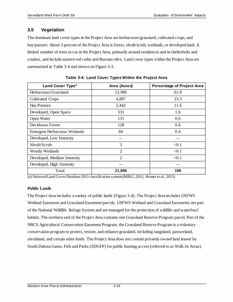
3.5 Vegetation The dominant land cover types in the Project Area are herbaceous/grassland, cultivated crops, and
hay/pasture. About 3 percent of the Project Area is forest, shrub/scrub, wetlands, or developed land. A limited number of trees occur in the Project Area, primarily around residences and in shelterbelts and
coulees, and include eastern red cedar and Russian olive. Land cover types within the Project Area are
summarized in Table 3-4 and shown on Figure 3-3.
Table 3-4: Land Cover Types Within the Project Area
Land Cover Typea Area (Acres) Percentage of Project Area
Herbaceous/Grassland 12,986 61.8 Cultivated Crops 4,897 23.3 Hay/Pasture 2,442 11.6 Developed, Open Space 331 1.6 Open Water 131 0.6 Deciduous Forest 128 0.6 Emergent Herbaceous Wetlands 84 0.4 Developed, Low Intensity -- -- Shrub/Scrub 3 <0.1 Woody Wetlands 2 <0.1 Developed, Medium Intensity 2 <0.1 Developed, High Intensity -- --
Total 21,006 100 (a) National Land Cover Database 2011 classification system (MRLC, 2011; Homer et al., 2015)
Public Lands
The Project Area includes a variety of public lands (Figure 3-4). The Project Area includes USFWS Wetland Easement and Grassland Easement parcels. USFWS Wetland and Grassland Easements are part
of the National Wildlife Refuge System and are managed for the protection of wildlife and waterfowl
habitat. The northern end of the Project Area contains one Grassland Reserve Program parcel. Part of the
NRCS Agricultural Conservation Easement Program, the Grassland Reserve Program is a voluntary conservation program to protect, restore, and enhance grassland, including rangeland, pastureland,
shrubland, and certain other lands. The Project Area does not contain privately owned land leased by
South Dakota Game, Fish and Parks (SDGFP) for public hunting access (referred to as Walk-In Areas).

Sw eetland Wind Farm Draft EA Evaluation of Environment Impacts
Western Area Pow er Administration 3-17
Figure 3-3: Land Cover

Sw eetland Wind Farm Draft EA Evaluation of Environment Impacts
Western Area Pow er Administration 3-18
Figure 3-4: Public Lands and Conservation Easements

Sw eetland Wind Farm Draft EA Evaluation of Environment Impacts
Western Area Pow er Administration 3-19
Grasslands
A grassland habitat assessment evaluated the quality of potential grasslands in a study area, which included the Project Area. Refer to the grassland habitat assessment in Appendix E for details regarding
the specific study area and assessment methodology. Potentially undisturbed grasslands (i.e., grasslands
that have not previously been tilled) were initially identified based on publicly available digital data
(Bauman et al., 2013) and recent aerial photography. The assessment rated the quality of grasslands as Excellent, Above Average, Average, Fair, or Poor. Excellent grasslands were undisturbed native
grasslands that both showed no evidence of previous tilling and were dominated entirely by native
tallgrass species. There were no Excellent grasslands documented in the study area. Above Average grasslands were defined as grasslands with non-native grassland species (such as smooth brome)
prevalent but native grasses still commonly occurred. Three percent, or 448 acres, of the grasslands
assessed in the study area were Above Average grasslands, and these were located in isolated patches
generally limited to ravine edges and on slopes.
The remaining grasslands in the study area were rated as Average (18 percent or 2,182 acres; dominated
by introduced grasses with infrequent native grasses), Fair (57 percent or 6,778 acres; dominated by
introduced grasses with no native grasses present), or Poor (19 percent or 2,229 acres; hayfields or any grassland severely overgrazed by livestock), and a small amount (1 percent or 182 acres) was not scored
because it could not be viewed from the roads or access was limited.
No undisturbed native grasslands were documented in the study area.
Noxious Weeds According to the South Dakota Department of Agriculture (SDDOA), four state-listed and two county-
listed noxious weed species are known to occur in Hand County (SDDOA, 2017a and 2017b), as
identified in Table 3-5.
Table 3-5: State and Local Noxious Weeds of South Dakota
State Noxious Weeds County Noxious Weeds Leafy spurge Absinth wormwood Canada thistle Musk thistle
Perennial sow thistle Hoary cress
Source: SDDOA, 2017a and 2017b
Sw eetland Wind Farm Draft EA Evaluation of Environment Impacts
Western Area Pow er Administration 3-20
3.5.1 Environmental Consequences: Proposed Action The following environmental commitments would be implemented:
• Minimize disturbance to Above Average grasslands.
• Site turbines, access roads, switchyards, Project substation, and laydown yard/O&M building to
avoid USFWS Grassland or Wetland Easements.
• Site the gen-tie line to avoid or span USFWS Grassland or Wetland Easements
• Site crane paths and collection lines to avoid USFWS Grassland and Wetland Easements to the
extent practicable.
• Avoid siting turbines in wetlands and water bodies.
• Bore under USFWS Wetland Easement(s) to avoid disturbance.
• Locate gen-tie line in areas where previous disturbance has occurred to the extent feasible,
thereby minimizing impacts to trees and associated wildlife.
• Minimize the area disturbed during the installation of meteorological towers (i.e., the footprint needed for meteorological towers and associated laydown areas).
• Reduce habitat disturbance by keeping vehicles on access roads and minimizing foot and vehicle
traffic through undisturbed areas.
• Initiate habitat restoration of disturbed soils and vegetation as soon as possible after construction activities are completed. Restore areas of disturbed soil using weed-free native grasses, forbs, and
shrubs, in consultation with land managers and appropriate agencies such as State or County
extension offices or weed boards.
• Develop restoration plans to verify all temporary use areas are restored.
• Develop a plan for control of noxious weeds and invasive plants that could occur as a result of
new surface disturbance activities at the site. The plan shall address monitoring, weed identification, the manner in which weeds spread, and methods for treating infestations. Require
the use of certified weed-free mulching.
• Vehicles shall be washed outside of active agricultural areas to limit the possibility of the spread
of noxious weeds.
• Establish a controlled inspection and cleaning area for trucks and construction equipment arriving
from locations with known invasive vegetation problems. Visually inspect construction
equipment arriving to the Project Area and remove and contain seeds that may be adhering to tires and other equipment surfaces.
Sw eetland Wind Farm Draft EA Evaluation of Environment Impacts
Western Area Pow er Administration 3-21
• Annually monitor access roads and newly established utility and transmission line corridors for
the establishment of invasive species. Initiate weed control measures immediately upon evidence of the introduction or establishment of invasive species.
• Do not use fill materials that originate from areas with known invasive vegetation problems.
• Access roads, utility and transmission line corridors, and tower site areas shall be monitored
regularly for the establishment of invasive species, and weed control measures should be initiated immediately upon evidence of the introduction of invasive species.
• Salvage and reapply topsoil excavated during decommissioning activities to disturbed areas
during final restoration activities.
• Reclaim areas of disturbed soil using weed-free native shrubs, grasses, and forbs. Restore the
vegetation cover, composition, and diversity to values commensurate with the ecological setting.
• Restore and regrade disturbed soils after construction. The construction contractor would
coordinate with the NRCS and/or the landowner on native seed mixes for revegetation. The seed mixes and revegetation plan would be developed as part of the SWPPP for the Project.
Project construction, operation, and decommissioning would impact agricultural and non-agricultural
land. Agricultural land includes cultivated crops and hay/pasture (Table 3-4). Non-agricultural land includes herbaceous/grassland, emergent herbaceous wetlands, woody wetlands, shrub/scrub, deciduous
forest, open water, and developed land (open space, low intensity, medium intensity, and high intensity)
(Table 3-4).
Assuming all 80 wind turbine locations, construction of the Project would temporarily disturb up to 810 acres of vegetation, about half agricultural land (cropland, hay, pasture) and half non-agricultural land
(grassland). Project construction would result in a temporary loss of production of crops and pasture
grasses. Non-agricultural land impacts would include up to 18 acres of Above Average grasslands. The remainder of impacts to non-agricultural land would occur to grasslands rated as Average quality or
below. These grassland types are dominated by introduced species, affected by grazing impacts, and/or
experiencing effects of invasive species such as noxious weeds or woody vegetation.
Following construction, the temporary impact areas not maintained would be returned to pre-construction land uses, primarily cultivated croplands, hay, and pastureland.
Isolated trees may need to be cleared as part of construction, particularly to allow safe operation of the
gen-tie line. The wind farm construction footprint would overlap approximately 1 acre of deciduous forest, as identified in the National Land Cover Database (MRLC, 2011). The gen-tie line route would not

Sw eetland Wind Farm Draft EA Evaluation of Environment Impacts
Western Area Pow er Administration 3-22
affect any forest acres. Tree removal would occur under the gen-tie line or to bring in underground
collection lines, but would be limited to individual trees in proposed development corridors. Some minor clearing of shrubs also may be required during construction. Impacted trees would be replanted to achieve
maturity within 5 to 10 years, and native shrubs are typically fast-growing and are expected to provide
wildlife habitat within 2 to 5 years.
Project construction would potentially impact Grassland Reserve Program Conservation Easement land. The Project would not construct Turbines 8, 9, or 10 on the Grassland Reserve Program Conservation
Easement without prior consultation and approval of the landowner and the NRCS. Sweetland is
consulting with the NRCS to obtain approval to site wind facilities within the Grassland Reserve Program easements.
Vegetation within USFWS Wetland Easements would not be directly impacted because the Project would
avoid, span across, or bore underneath the wetland.
Project construction could result in potential temporary impacts from the installation of underground collection lines on up to four USFWS Grassland Easements. Also, 1.2 miles of temporary crane paths
would cross USFWS Grassland Easements; however, as discussed in Section 2.1.2, no grading or other
surface disturbance would be required to create the crane paths, and Sweetland would use cranes with inflatables to minimize compaction and disturbance, if this type of crane is available for use on the
Project. The Project would not create surface disturbance on USFWS Grassland Easements. The gen-tie
line route would not place structures on a USFWS Grassland Easement; it would span these easements.
The gen-tie line would be marked with bird diverters, which would be maintained for the life of the Project. Because the Project would avoid surface disturbance to USFWS Grassland Easements, it would
not need to obtain a permit(s) from USFWS for impacts to Grassland Easements.
Construction activities have the potential to result in the spread of noxious weed species from construction equipment introducing seeds into new areas, or erosion or sedimentation due to clearing
ground in the construction areas. Implementation of environmental commitments would reduce the
potential for the introduction of noxious weeds.
Operation of the Project would remove approximately 73 acres of vegetation, about half agricultural land (cropland, hay, pasture) and half non-agricultural land (grasslands). During Project operation, portions of
the construction areas would return to prior land uses (agricultural or non-agricultural). However, Project
operation would have long-term impacts on vegetation in the areas occupied by Project components.
Project operation would impact up to 37 acres of grasslands (depending on the final placement of

Sw eetland Wind Farm Draft EA Evaluation of Environment Impacts
Western Area Pow er Administration 3-23
facilities, including the O&M building), including 1 acre of Above Average grasslands. The majority of
long-term grassland impacts would be to average or low quality grasslands. The long-term Above Average grassland impact is less than 0.5 percent of the total Above Average grassland acreage in the
Project Area (448 acres).
Additional operational impacts would occur from routine vegetation maintenance to manage woody
vegetation that could interfere with the gen-tie line and to reduce the potential for wildfires.
The facility would be decommissioned at the end of the Project’s operating life. Facilities would be
removed in accordance with the wind lease, applicable State regulations, and county agreements, unless
otherwise agreed to by the landowner. Disturbed surfaces would be graded, reseeded, and restored as closely as possible to their pre-construction conditions. Impacts from decommissioning would be similar
to those for construction.
3.5.2 Environmental Consequences: No Action Alternative The No Action Alternative would have no direct or indirect impacts on vegetation. Existing activities, such as farming and the trend toward conversion of undeveloped land to agriculture, would likely
continue. These types of activities can alter vegetation.
3.6 Wildlife Various wildlife studies were completed for the Project. These studies are listed in Table 3-6 and included in Appendices F through J. The study results are summarized in the subsections that follow. Refer to the
appendices for descriptions of the specific study areas and the methods used.
Table 3-6: Sweetland Wind Farm Wildlife Studies
Study Date Baseline Avian Study, Year 1 Studies May 2017 to April 2018 Baseline Avian Study, Year 2 Studies May 2018 to April 2019 Bat Activity Study 2017 Report June to October 2017 Bat Activity Study 2018 Report May to October 2018 Bat Summer Presence/Absence Survey Report November 14, 2018 Eagle and Raptor Nest Surveys 2017 (Year 1) Report March and May 2017 Eagle and Raptor Nest Surveys 2018 (Year 2) Report March and May 2018 Whooping Crane Stopover Habitat Assessment Report December 2018

Sw eetland Wind Farm Draft EA Evaluation of Environment Impacts
Western Area Pow er Administration 3-24
Raptors
Aerial raptor nest surveys were completed in spring of 2017 and 2018 to characterize the raptor nesting community and locate raptor stick nests, including eagle nests, and the complete details of the methods
and results are found in Appendix F. During 2017, no occupied bald eagle nests were observed, and there
were 17 active nests and 16 unoccupied nests. The 17 active nests were red-tailed hawk (9 nests), great
horned owl (4 nests), Swainson’s hawk (2 nests), and unknown raptor (2 nests). In 2018, one occupied active bald eagle nest with one chick was located over 5.5 miles north of the study area. There were 5
active raptor nests (4 red-tailed hawk nests and 1 great horned owl nest) and 13 unoccupied nests
recorded in 2018.
Bald and golden eagles were observed during the course of raptor nest surveys in 2017 and 2018, as
would be expected during large-scale surveys during spring migration. These sightings may have multiple
observations of the same individuals. In 2017, 53 bald eagles were observed during 10 instances: 3
observations totaling 43 bald eagles were clustered at small lakes within 1.5 miles of each other approximately 8.2 miles south of the study area, and 7 instances totaling 10 bald eagles were observed
throughout the study area. No golden eagles were observed in 2017. In 2018 surveys, 45 bald eagles and
12 golden eagles were observed during 38 instances: 10 bald eagle and 8 golden eagle observations occurred within 5 miles of the study area, while the remaining observations occurred at least 5 miles from
the study area.
Two years of avian use surveys were completed in 2017-2018 and 2018-2019. Avian use surveys
conducted during year one recorded six golden eagles, four bald eagles, and two unidentified eagles. Golden eagles were observed during the summer and winter seasons while bald eagles were observed
during the spring and winter seasons. Based on year one survey results, a small number of either eagle
species was observed at any time of the year. Avian use surveys conducted during year two recorded no golden eagles and a single bald eagle. The bald eagle was observed during the winter. Based on the avian
use survey results across both years, a small number of either eagle species was observed at any time of
the year.
Based on the survey results, the eagle use in the area is estimated to be low.
Birds
The Project Area does not overlap with any Important Bird Areas (as designated by the National Audubon
Society) and none are located in Hand County (National Audubon Society, 2019). The Project Area
overlaps with a Grassland Bird Conservation Area (Johnson et al., 2010). Many of the bird species

Sw eetland Wind Farm Draft EA Evaluation of Environment Impacts
Western Area Pow er Administration 3-25
reported from the Project Area are seasonal migrations. These birds include waterfowl, waterbirds,
shorebirds, raptors, and neotropical songbirds. A major migration flyway, the Central Flyway crosses South Dakota (Lincoln et al., 1998).
The most common species groups observed during field surveys in 2017 included waterfowl, gulls/terns,
and waterbirds. The surveys resulted in over 47,000 waterfowl observations (snow goose accounted for
nearly 42,800), over 4,600 gulls/terns observations (Franklin’s gull accounted for over 2,100), and 1,100 waterbird observations (sandhill crane accounted for all but 33 of the observations). Nationally, the
waterfowl population includes an estimated 48.4 million breeding ducks and 11.8 million migrating
mallards (USFWS, 2016).
A total of 42 unique small bird species were observed during the small bird surveys in the year one and
year two avian use studies. The most common small bird species in the year one study included the barn
swallow (124 observations), red-winged blackbird (91 observations), and house sparrow (90
observations). The most common small bird species in the year two study included the horned lark (332 observations), red-winged blackbird (301 observations), and brown-headed cowbird (214 observations),
and barn swallow (182 observations).Species of special concern are discussed in the subsection below.
Species of Special Concern Species of special concern include USFWS Birds of Conservations Concern (BCC), South Dakota
Species of Greatest Conservation Need (SGCN), and prairie grouse (USFWS, 2008 and SDGFP, 2014).
Note that threatened and endangered species are discussed in Section 3.7.
BCC are species in need of coordinated and proactive conservation efforts among State, Federal, and private entities. Nine species listed on the BCC for the Prairie Pothole Region were observed during avian
use surveys in 2017-2018: bald eagle, Swainson’s hawk, peregrine falcon, upland sandpiper, marbled
godwit, black tern, red-headed woodpecker, grasshopper sparrow, and dickcissel. Eight species listed on the BCC for the Prairie Pothole Region were observed during avian use surveys in 2018-2019: bald eagle,
Swainson’s hawk, upland sandpiper, long-billed curlew, marbled godwit, red-headed woodpecker,
grasshopper sparrow, and dickcissel.
SDGFP has identified SGCN within the South Dakota State Wildlife Action Plan (SDGFP, 2014). Four SGCN were recorded during 2017-2018 avian use surveys: American white pelican (7 observations),
black tern (1 observation), Le Conte’s sparrow (3 observations), and marbled godwit (12 observations). A
single group of greater prairie-chicken (with four individuals) was observed during surveys in 2017. In
addition to an observed bald eagle, SGCN were recorded during 2018-2019 avian use surveys: marbled

Sw eetland Wind Farm Draft EA Evaluation of Environment Impacts
Western Area Pow er Administration 3-26
godwit (14 observations), American white pelican (10 observations), long-billed curlew (2 observations),
ferruginous hawk (1 observation), and lark bunting (1 observation). Greater prairie-chickens were observed during 2019 surveys, as discussed in the following paragraph.
Surveys in 2018 identified three locations where sharp-tailed grouse were displaying in or within 1 mile
of the Project Area. Two locations were approximately 1 mile and 0.4 mile, respectively, from the nearest
proposed turbine. The third location was approximately 0.2 mile from the center of the proposed Project substation location. Surveys in 2019 identified sharp-tailed grouse at or near these same three locations
identified in 2018. SDGFP defines a lek as the traditional display area where two or more male grouse
have attended in two or more of the previous 5 years. The three sharp-tailed grouse locations that were observed in 2018 and 2019 are classified as leks according to SDGFP. One of the leks is located within
the Project Area, and the other two are located within 1 mile of the Project Area.
In addition, during surveys in 2019, sharp-tailed grouse and great prairie chickens were also observed
dancing/displaying at three new locations. The three dancing/displaying locations observed in 2019 do not meet SDGFP’s definition of a lek, since only 1 year of data has been collected in the last 5 years for those
locations. All three of the dancing/displaying locations are outside of the Project Area but within 1 mile.
Bats Seven bat species are potential residents and/or migrants in the study area, including big brown bat,
eastern red bat, hoary bat, silver-haired bat, northern long-eared bat, little brown bat, and western small-
footed bat. The only federally listed bat species with the potential to occur is the northern long-eared bat,
and a study designed specifically to determine if this species is present at the Project is described in Section 3.7.
The results of the general bat acoustic surveys in 2017 and 2018 were analyzed and grouped into two
categories of acoustic frequencies: high frequency calls and low frequency calls. Calls were not identified to species. High frequency calls could include species such as the eastern red bat, western small-footed
bat, little brown bat, and northern long-eared bat. Low frequency calls could include species such as the
big brown bat, silver-haired bat, and hoary bat. Approximately 27 to 44 percent of the calls during the
surveys were high frequency, and approximately 56 to 73 percent of the calls during the surveys were low frequency.
Activity peaked during the late summer/early fall when bats migrate, but was fewer than 1.5 bat passes
per detector night during both the summer and fall seasons during both years. These bat activity estimates

Sw eetland Wind Farm Draft EA Evaluation of Environment Impacts
Western Area Pow er Administration 3-27
are relatively lower than those seen at other studies in the Midwest (see Appendix A of both the 2017 and
2018 bat reports, included in this EA as Appendix H).
3.6.1 Environmental Consequences: Proposed Action The following environmental commitments would be implemented:
• The eagle risk calculation will be run for the current proposed turbine model. If the proposed
wind turbine model changes, and the change results in a larger rotor swept area, then the Developer will re-run eagle risk calculations and submit the results to USFWS and WAPA.
• Where applicable, the Project’s aboveground power lines shall be designed and constructed to
minimize avian electrocution and collision risks, referencing guidelines outlined in the Avian
Power Line Interaction Committee’s (APLIC) Suggested Practices for Avian Protection on Power Lines: The State of the Art in 2006 and Reducing Avian Collisions with Power Lines: The
State of the Art in 2012.
• Implement a Bird and Bat Conservation Strategy (BBCS) in accordance with the USFWS Wind Energy Guidelines to minimize impacts to avian and bat species during construction and
operation of the Project.
• Conduct post-construction fatality monitoring for 2 years to assess impacts.
• Conduct 2 years of post-construction lek/grouse monitoring. This includes using lights with timed shutoff, downward-directed lighting to minimize horizontal or skyward illumination, and
avoidance of steady-burning, high-intensity lights.
• Feather turbine blades below the cut-in wind speed of 3 meters per second.
• Monitor regularly for wildlife mortality as described in the BBCS. Report observations of wildlife
mortality to the appropriate state or federal agency in a timely manner, and work with the
agencies to use this information to avoid/minimize/offset impacts. Further in accordance with the
BBCS, any incident involving a state or federally listed threatened or endangered species or a golden or bald eagle will be reported to the USFWS and the SDGFP within 24 hours of
identification.
• Instruct employees, contractors, and site visitors to avoid harassment and disturbance of wildlife, especially during reproductive (e.g., courtship and nesting) seasons. Pets shall not be allowed in
the Project Area.
• Established wind turbine buffer zones around known raptor nests (0.25-mile).

Sw eetland Wind Farm Draft EA Evaluation of Environment Impacts
Western Area Pow er Administration 3-28
• If needed during construction, only use explosives within specified times and at specified
distances from sensitive wildlife or surface waters as established by the appropriate Federal and State agencies.
• During project operation, use designs for meteorological towers that do not require guy wires.
• Promptly dispose of all garbage or human waste generated onsite in order to avoid attracting
nuisance wildlife.
• Train O&M staff to recognize sensitive species.
• Place marking devices on any newly constructed or upgraded transmission lines and maintain
throughout the life of the project.
Wildlife species would be impacted locally during the construction phase of the Project. Habitat
alteration, degradation, fragmentation, and removal would occur from grading and clearing or
introduction of invasive vegetation. Individuals of wildlife species may temporarily avoid the
construction zone due to increased noise and physical disturbance.
During Project operation, direct mortality or injury would occur if wildlife collides with vehicles or
turbines. There is a probability of death and reproductive failure if occupied breeding habitat is removed
or altered, habitat is fragmented by the presence of aboveground Project facilities, or increased noise or physical disturbance occurs in proximity to vulnerable breeding wildlife. Less common wildlife species
may be impacted by the Project, although impacts are expected predominantly to occur to common
species adapted to agricultural and edge habitats. Population-level impacts are not anticipated.
Decommissioning impacts would be similar to those temporary impacts described for the construction phase.
Birds
Impacts to avian species from Project construction and operation could be direct or indirect, could occur during and after construction and operation, and could be within or outside the Project Area. Potential
direct impacts could affect a variety of birds, including passerines (small birds such as songbirds),
waterfowl, and raptors. Indirect impacts to birds can also occur at different time scales (e.g., during and
after construction and operation) and spatial scales (e.g., within or outside the Project Area). Indirect impacts are often unintended, may produce unforeseen consequences, and are difficult to predict. In this
EA, indirect impacts will focus on what could occur at the Project.
During Project construction, direct impacts would include fatalities from collisions with construction equipment or Project components being installed at the site. Project construction also would result in

Sw eetland Wind Farm Draft EA Evaluation of Environment Impacts
Western Area Pow er Administration 3-29
indirect impacts such as habitat loss and/or alteration and the potential temporary displacement or
disturbance of avian species, including grassland species. Similarly, construction impacts to wetlands could lead to displacement of local birds in the study area. The small amount of wetlands impacted by the
Project during construction minimizes the potential impact to birds using these habitats.
During Project operation, direct impacts would include fatalities from operation of the Project. Based on a
review of other wind projects in the region, fatalities estimates for all birds (including waterfowl) ranged between 0.27 and 8.25 fatalities/MW/year. It is anticipated this Project would result in an average of 4.57
fatalities/MW/year (Appendix G). The overall magnitude of these population impacts is low, particularly
for passerines because most (approximately 62 percent) of the documented avian fatalities in continental North America are of passerines with individual species experiencing small (less than 0.05 percent) direct
impacts from collisions with wind turbines (Erickson et al., 2014).
For waterfowl alone, not including other types of birds, fatality estimates range between 0.38 and 0.78
fatalities/MW/year (Derby et al., 2012, 2013). This level of mortality is not expected to impact waterfowl populations on a national scale. Similarly, the only study in the region producing fatality estimates
specifically for raptors active during the day ranged from 0.06 to 0.07 fatalities/MW/year, and these
estimates would not affect raptor populations, based on the studies/reviews that have evaluated this issue (Derby et al., 2010, 2011).
Operation of the Project may also result in indirect impacts (i.e., displacement) of local birds in the study
area. Based on studies in the Great Plains, seven of nine grassland-breeding birds had greater
displacement effects over the long-term (2 to 5 years after construction) compared to immediately after construction and showed some displacement up to 300 meters from wind turbines (Shaffer and Buhl,
2016). Of these seven grassland-breeding birds, grasshopper sparrow and upland sandpiper (which are
BCC, not SGCN) were detected in the Project study area. The remaining five of the seven were not detected at the Project study area, not displaced at the South Dakota study site, or not listed as BCC.
Displacement impacts would not likely be realized at the population level in part because displaced birds
are not precluded from breeding elsewhere. However, the Project could result in habitat fragmentation
that would create a group of spatial and successional habitats from formerly contiguous habitat (Lehmkuhl and Ruggiero, 1991). For example, habitat fragmentation can result from roads, transmission
lines, or the construction of new structures on the landscape, and from soil or vegetation disturbance.
Connectivity between fragmented habitat segments decreases with increased spacing between the
segments (Jalkotzy et al., 1997). With habitat fragmentation, some wildlife species may benefit from the

Sw eetland Wind Farm Draft EA Evaluation of Environment Impacts
Western Area Pow er Administration 3-30
changes while other species may be negatively impacted. Those that benefit are often generalist species,
whereas the species impacted are often species of conservation concern.
Project operation also could result in indirect impacts (i.e., displacement) to waterbirds. Based on studies
of five species of waterfowl in the Great Plains, waterfowl showed a median displacement of 21 percent,
and approximately half of the study sites showed a reduction in breeding pairs (Loesch et al., 2013).
Loesch et al. (2013) were unable to assess the potential for cumulative impacts of wind facilities on breeding waterfowl.
The Project would not result in furthering the likelihood of the following BCC species to become
candidates for listing under the Endangered Species Act: bald eagle, Swainson’s hawk, peregrine falcon, upland sandpiper, marbled godwit, black tern, red-headed woodpecker, grasshopper sparrow, or
dickcissel. The Project would not result in compromising the security or recovery of the following SGCN
species: American white pelican, black tern, Le Conte’s sparrow, or marbled godwit. The estimated levels
of avian fatalities at the Project are such that impacts to any individual species would not likely affect population levels. Indirect impacts including raptor displacement from occupied nests is anticipated to be
nominal as the Project has applied a 0.25-mile buffer from occupied raptor nests. Other indirect impacts
to birds are also anticipated to be nominal as low numbers of species of concern were observed at the Project and the effect of displacement on breeding birds has unknown impacts on avian populations.
The Project could potentially result in direct and indirect impacts to sharp-tailed grouse. The Project may
pose a risk of mortality (direct impact) and/or breeding disturbance (indirect impact) to sharp-tailed
grouse because there are two dancing/displaying locations within approximately 1 mile of turbines and upland gamebird fatalities are known from post-construction fatality surveys at wind energy facilities
(Johnson and Holloran, 2010). However, post-construction lek monitoring would be conducted in
consultation with SDGFP.
Decommissioning impacts would be similar to those temporary impacts described for the construction
phase.
Implementation of environmental commitments during all phases of the Project would reduce the
potential for avian mortality, indirect effects, and population-level effects. A BBCS has been prepared for the Project to identify and implement actions to conserve birds and bats during construction, operation,
and maintenance. The BBCS is included as Appendix I. The BBCS requires post-construction monitoring
to confirm the pre-construction risk analysis and would include adaptive management measures, if
needed, in consultation and coordination with agencies.
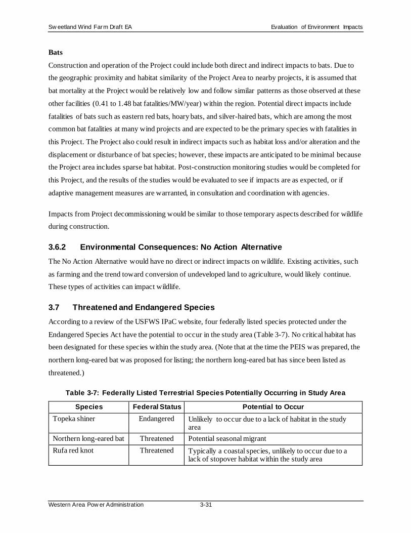
Sw eetland Wind Farm Draft EA Evaluation of Environment Impacts
Western Area Pow er Administration 3-31
Bats
Construction and operation of the Project could include both direct and indirect impacts to bats. Due to the geographic proximity and habitat similarity of the Project Area to nearby projects, it is assumed that
bat mortality at the Project would be relatively low and follow similar patterns as those observed at these
other facilities (0.41 to 1.48 bat fatalities/MW/year) within the region. Potential direct impacts include
fatalities of bats such as eastern red bats, hoary bats, and silver-haired bats, which are among the most common bat fatalities at many wind projects and are expected to be the primary species with fatalities in
this Project. The Project also could result in indirect impacts such as habitat loss and/or alteration and the
displacement or disturbance of bat species; however, these impacts are anticipated to be minimal because the Project area includes sparse bat habitat. Post-construction monitoring studies would be completed for
this Project, and the results of the studies would be evaluated to see if impacts are as expected, or if
adaptive management measures are warranted, in consultation and coordination with agencies.
Impacts from Project decommissioning would be similar to those temporary aspects described for wildlife during construction.
3.6.2 Environmental Consequences: No Action Alternative The No Action Alternative would have no direct or indirect impacts on wildlife. Existing activities, such
as farming and the trend toward conversion of undeveloped land to agriculture, would likely continue. These types of activities can impact wildlife.
3.7 Threatened and Endangered Species According to a review of the USFWS IPaC website, four federally listed species protected under the
Endangered Species Act have the potential to occur in the study area (Table 3-7). No critical habitat has been designated for these species within the study area. (Note that at the time the PEIS was prepared, the
northern long-eared bat was proposed for listing; the northern long-eared bat has since been listed as
threatened.)
Table 3-7: Federally Listed Terrestrial Species Potentially Occurring in Study Area
Species Federal Status Potential to Occur Topeka shiner Endangered Unlikely to occur due to a lack of habitat in the study
area Northern long-eared bat Threatened Potential seasonal migrant Rufa red knot Threatened Typically a coastal species, unlikely to occur due to a
lack of stopover habitat within the study area

Sw eetland Wind Farm Draft EA Evaluation of Environment Impacts
Western Area Pow er Administration 3-32
Species Federal Status Potential to Occur Whooping crane Endangered Study area is within the migration corridor; potential
seasonal migrant Source: USFWS 2018a
Topeka Shiner The Topeka shiner is a small minnow known to occupy the James River watershed. Based on a drainage
basin analysis (USGS, 2018), the upper drainage basins to East Pearl Creek and Silver Creek are within
the Project Area and are intermittent in the Project Area.
Northern Long-Eared Bat
The northern long-eared bat is a forest bat species that roosts alone or in colonies under bark, cavities, or
crevices in living or dead trees. The study area is on the western fringe of the estimated range for the
northern long-eared bat (BCI, 2018). The study area contains 280 acres of potentially suitable summer habitat for the northern long-eared bat. Information from the National Land Cover Database indicates 157
acres of the Project Area is deciduous forest (Table 3-4).
Sweetland conducted site-specific acoustic presence/absence surveys for the northern long-eared bat (Appendix J) according to USFWS protocol guidelines (USFWS, 2018b). No potential northern long-
eared bat calls were identified; therefore, no qualitative review was necessary and no follow-up mist-net
or telemetry surveys were performed. The acoustic survey results show probable absence of northern
long-eared bat within the study area during the summer, but the species may pass through the study area as a seasonal migrant. There are no Natural Heritage Information System records of northern long-eared
bat hibernacula within the vicinity of the Project Area; the nearest publicly available northern long-eared
bat hibernaculum is in eastern Stearns County, Minnesota, more than 200 miles east (Minnesota DNR/USFWS, 2018).
Rufa Red Knot
The Project Area contains no suitable breeding or foraging habitat for the rufa red knot, which is a rare
transient in inland parts of its range. In North America, red knots are commonly found along sandy, gravel, or cobble beaches, tidal mudflats, salt marshes, shallow coastal impoundments and lagoons, and
peat banks (USFWS, 2015b). Depending on the year, the nearest potential suitable stopover habitat for the
species is the Missouri River located 35 miles west. No rufa red knots were observed during baseline avian surveys conducted for the Project.

Sw eetland Wind Farm Draft EA Evaluation of Environment Impacts
Western Area Pow er Administration 3-33
Whooping Crane
Whooping crane migration occurs in a corridor between the Texas gulf coast to Canada’s northwest territories, during which the whooping crane is susceptible to mortality from manmade structures. The
study area is located in bands where 90 to 95 percent of migratory whooping crane observations have
occurred (WAPA and USFWS, 2015b). (The more recent study by Pearse et al. [2018] indicated the study
area is located in the 75 percent migration corridor; this study was used for Figure 3-5). According to the Cooperative Whooping Crane Tracking Project (CWCTP; USFWS, 2017), no observations of whooping
cranes have occurred within the study area. Based on CWCTP data, the nearest historical sighting to the
study area occurred approximately 4 miles east (Figure 3-5). Through spring 2017, three whooping crane observations were confirmed within a 10-mile buffer of the Project Area (USFWS, 2017).

Sw eetland Wind Farm Draft EA Evaluation of Environment Impacts
Western Area Pow er Administration 3-34
Figure 3-5: Whooping Crane Migration Corridor

Sw eetland Wind Farm Draft EA Evaluation of Environment Impacts
Western Area Pow er Administration 3-35
The Project included a site-specific whooping crane stopover habitat assessment (Appendix K) of the
study area and surrounding 10-mile buffer and identified 74 wetlands (563 acres) suitable for crane habitat. This assessment was done via desktop using a model developed by The Watershed Institute, Inc.
Suitable habitat for whooping cranes is scattered throughout the study area and is generally of lower
quality than in surrounding areas (Figure 3-6). The highest concentration of higher quality suitable stop-
over habitat (primarily pothole wetlands) occurs along the southwestern edge of the study area, but these areas are relatively less dense than the higher quality stopover habitat in surrounding landscapes.
Furthermore, the attractiveness of potential stopover habitat within the study area is likely to be reduced
somewhat by the presence of existing disturbance features (e.g., roads, dwellings) (Pearse et al., 2015).
There is the potential for whooping cranes to use or fly through the area during the life of the Project, but
this is not expected to be a frequent event given the low number of cranes in the population that migrates
across the relatively wide (200+ miles) migration corridor, as well as the low number observed
historically in the vicinity of the Project. Additionally, no whooping cranes have been observed, to date, during surveys.
3.7.1 Environmental Consequences: Proposed Action Environmental commitments for water resources (Section 3.2), vegetation (Section 3.5) and wildlife
(Section 3.6) would apply for threatened and endangered species.
For EAs that tier off of the PEIS, species consistency evaluation forms have been developed for the listed,
candidate, or proposed species that may occur within the region. This EA tiers off the PEIS, and the draft
species consistency evaluation forms are attached in Appendix L.
Topeka Shiner
The Project would not result in additional sediment or pollutant to waters that are occupied or potentially
occupied. Additionally, the project is distant from the occupied James River and would not result in
stream flow alterations. Although Project activities would occur in the Middle James Watershed, adherence to BMPs and species-specific minimization measures remove the risk of exposure. Therefore,
WAPA has determined the Project will have no effect to the Topeka shiner.

Sw eetland Wind Farm Draft EA Evaluation of Environment Impacts
Western Area Pow er Administration 3-36
Figure 3-6: Whooping Crane Stopover Habitat

Sw eetland Wind Farm Draft EA Evaluation of Environment Impacts
Western Area Pow er Administration 3-37
Northern Long-eared Bat
Operation of the Project could impact the northern long-eared bat because there is potential for collisions with turbines if the bat passes through the area during migration and the turbines are operating, resulting
in injury or fatality. However, the probable absence of the northern long-eared bats in the study area
indicates a low collision risk. The Project site is more than 35 miles from the Missouri River, and the
likelihood of hibernacula or suitable habitat decreases with distance from rivers. The nearest hibernaculum is 200 miles away and very few trees are slated for removal. Thus, there is a discountable
risk of roost removal or disturbance to individuals during construction. No additional impacts would
results from construction, maintenance, or decommissioning of the Project. The Project would immediately report detections of northern long-eared bat injury or mortality to the appropriate USFWS
office. Therefore, WAPA has determined the Project may affect, not likely to adversely affect northern
long-eared bat.
Rufa Red Knot No suitable habitat for rufa red knot is in the Project vicinity. Transient individuals are not expected to
occur in the Project Area because there are no known detection records in Hand County. Therefore, there
is no anticipated risk of exposure to collision mortality, disruption, displacement, or habitat loss. Therefore, WAPA determined the Project will have no effect to the rufa red knot.
Whooping Crane
Project construction may result in displacement of whooping crane from suitable habitat. The risk of
displacement is low because the potentially suitable stopover wetlands in the study area are generally lower quality than in the surrounding areas, and the area does not have any sighting records. Furthermore,
no whooping cranes have been observed during surveys to date, though three historic crane observations
are within 10 miles of the Project. A whooping crane monitoring plan and shutdown protocol has been developed for the Project (Appendix M). Future monitoring, as described in the plan, may detect cranes if
they pass through the Project area. If cranes were detected, they would be protected through
implementation of the plan, which includes a shutdown protocol.
Impacts to whooping cranes during operation and maintenance could include direct mortality or injury from collision with turbines, meteorological towers, or the gen-tie line. However, this potential risk is
discountable in part because no whooping crane fatalities have been reported during post-construction
monitoring at operating wind farms (Mabee, 2019). The gen-tie line spans one to three wetlands that
could be suitable for whooping cranes, but they would be marked with bird flight diverters, which would

Sw eetland Wind Farm Draft EA Evaluation of Environment Impacts
Western Area Pow er Administration 3-38
be maintained through the life of the Project. As mentioned, a whooping crane monitoring plan and
shutdown protocol has been developed for the Project.
Decommissioning impacts are not expected.
The Project would implement the following species-specific environmental commitments:
• Conduct pre-construction evaluation and/or surveys to identify wetlands that provide potentially
suitable stopover habitat and areas of occurrence within project boundaries.
• Place approved bird flight diverters on top static wire on any new or upgraded overhead collector,
distribution and transmission lines within 1 mile of suitable stopover habitat, and maintain
diverters through the life of the project.
• Establish a procedure for preventing whooping crane collisions with turbines during operations
by establishing and implementing formal plans for monitoring the project site and surrounding
area for whooping cranes during spring and fall migration periods throughout the operational life
of the project (or as determined by the local USFWS field office) and shutting down turbines and/or construction activities within 2 miles of the whooping crane sightings. Monitoring can be
done by existing onsite personnel trained in whooping crane identification. Sightings of
whooping cranes in the vicinity of the projects will be reported to the appropriate USFWS field office immediately.
• Instruct workers in identification and reporting of sandhill and whooping cranes and to avoid
disturbance of cranes present near project area.
WAPA has determined the Project may affect, not likely to adversely affect whooping crane.
3.7.2 Environmental Consequences: No Action Alternative With the No Action Alternative, there would be no effect to federally threatened or endangered species.
Effects to threatened and endangered species would likely continue at the current rate, with the possible
of exception of northern long-eared bats, which may decline at an increasing rate due to the continued spread of white-nose syndrome.
3.8 Visual Resources Cropland, pasture, grassland, and large open vistas with gently rolling topography visually dominate the
Project Area landscape.

Sw eetland Wind Farm Draft EA Evaluation of Environment Impacts
Western Area Pow er Administration 3-39
Existing structures in the Project Area include 18 occupied residences dispersed throughout, as well as
scattered farm buildings. U.S. Route 14 and South Dakota Highway 45 are north and west of the Project boundary, respectively. The Project Area is crossed by 369th Avenue running north/south and multiple
township roads throughout. WAPA’s existing Fort Thompson to Huron 230-kV transmission line crosses
the southeastern portion of the Project Area; the transmission line structures along this line are existing
vertical elements in the generally horizontal landscape.
Travelers through the Project Area would include local or regional traffic along U.S. Route 14 and State
Highway 45. No USFWS or SDGFP public hunting areas are present within the Project Area. A Game
Production Area (East Pearl Game Production Area) and a Waterfowl Production Area (Campbell Waterfowl Production Area) are adjacent to, but outside, the Project Area boundary (SDGFP, 2018;
USFWS, 2012a). Game Production Areas are State lands managed by the SDGFP for the production and
maintenance of wildlife. No scenic resources with sensitive viewsheds are located within the Project Area
or within viewing distance of the Project.
Shadow Flicker
Shadow flicker occurs when wind turbine blades pass in front of the sun to create recurring shadows on
an object. Such shadows occur only under very specific conditions, including sun position, wind direction, time of day, and other similar factors. Shadow flicker becomes less noticeable with increasing
distance from a wind turbine. Shadow flicker at distances greater than 10 rotor diameters (i.e., about
4,490 feet or 0.85 mile) is generally low intensity and considered imperceptible. At such distances,
shadow flicker is typically only caused at sunrise or sunset, when cast shadows are sufficiently long.
Shadow flicker impacts are not currently regulated in applicable State or Federal law. The Development
Agreement with Hand County limits shadow flicker resulting from Project wind turbines at currently
occupied residences to 30 hours per year or less, unless waived in writing by the owner of the occupied residence.
3.8.1 Environmental Consequences: Proposed Action The following environmental commitments would be implemented:
Project Design and Materials
• For ancillary buildings and other structures, low-profile structures shall be chosen whenever possible to reduce their visibility.
• Color selections for turbines shall be made to reduce visual impact and shall be applied uniformly
to tower, nacelle, and rotor, unless gradient or other patterned color schemes are used.

Sw eetland Wind Farm Draft EA Evaluation of Environment Impacts
Western Area Pow er Administration 3-40
• Grouped structures shall all be painted the same color to reduce visual complexity and color
contrast.
• For ancillary structures, materials and surface treatments shall repeat and/or blend with the
existing form, line, color, and texture of the landscape. If the Project will be viewed against an
earthen or other non-sky background, appropriately colored materials shall be selected for
structures, or appropriate stains/coatings shall be applied to blend with the Project’s backdrop.
• The operator shall use non-reflective paints and coatings on wind turbines, visible ancillary
structures, and other equipment to reduce reflection and glare.
• Turbines, visible ancillary structures, and other equipment shall be painted before or immediately after installation.
• Lighting for facilities shall not exceed the minimum required for safety and security, and full-
cutoff designs that minimize upward light scattering (light pollution) shall be selected. If possible,
site design shall be accomplished to make security lights nonessential. If possible, where they are necessary, security lights shall be extinguished except when activated by motion detectors (e.g.,
only around the substation).
• Commercial messages and symbols (such as logos, trademarks) on wind turbines shall be avoided and shall not appear on sites or ancillary structures of wind energy projects. Similarly, billboards
and advertising messages shall also be discouraged.
Construction
• A site restoration plan shall be in place prior to construction. Restoration of the construction areas shall begin immediately after construction to reduce the likelihood of visual contrasts associated
with erosion and invasive weed infestation and to reduce the visibility of affected areas as quickly
as possible.
• Disturbed surfaces shall be restored to their original contours as closely as possible and
revegetated immediately after, or contemporaneously with, construction, or when weather would
support growth of new vegetation. Prompt action shall be taken to limit erosion and to accelerate
restoring the pre-construction color and texture of the landscape.
• These visual impact avoidance and minimization objectives and activities shall be discussed with
equipment operators before construction activities begin.
• Existing rocks, vegetation, and drainage patterns shall be preserved to the extent practicable.
• Slash from vegetation removal shall be mulched and spread to cover fresh soil disturbances
(preferred) or shall be buried. Slash piles shall not be left in sensitive viewing areas.

Sw eetland Wind Farm Draft EA Evaluation of Environment Impacts
Western Area Pow er Administration 3-41
• For road construction, excess fill shall be used to fill uphill-side swales to reduce slope
interruption that would appear unnatural and to reduce fill piles.
• The geometry of road ditch design shall consider visual objectives; rounded slopes are preferred
to V-shaped and U-shaped ditches.
• Road-cut slopes shall be rounded, and the cut/fill pitch shall be varied to reduce contrasts in form
and line; the slope shall be varied to preserve specimen trees and nonhazardous rock outcroppings.
• Planting pockets shall be left on slopes, where feasible.
• Benches shall be provided in rock cuts to accent natural strata.
• Topsoil from cut/fill activities shall be segregated and spread on freshly disturbed areas to reduce
color contrast and aid rapid revegetation. Topsoil piles shall not be left in sensitive viewing areas.
• Excess fill material shall not be disposed of downslope in order to avoid creating color contrast
with existing vegetation/soils.
• Excess cut/fill materials shall be hauled in or out to minimize ground disturbance and impacts
from fill piles.
• Soil disturbance shall be minimized in areas with highly contrasting subsoil color.
• Where feasible, construction on wet soils shall be avoided to reduce erosion.
• Communication and other local utility cables shall be buried, where feasible.
• Culvert ends shall be painted or coated to reduce color contrasts with existing landscape, if approved by county, township, and/or landowner.
• Signage shall be minimized; reverse sides of signs and mounts shall be painted or coated to
reduce color contrasts with the existing landscape.
• The burning of trash shall be prohibited during construction; trash shall be stored in containers and/or hauled offsite.
• Litter must be controlled and removed regularly during construction.
• Dust abatement measures shall be implemented in arid environments to minimize the impacts of vehicular and pedestrian traffic, construction, and wind on exposed surface soils.
Operations and Maintenance
• Wind facilities and sites shall be actively and carefully maintained during operation. Wind energy
projects shall evidence environmental care, which would also reinforce the expectation and impression of good management for benign or clean power.
• Inoperative turbines shall be repaired, replaced, or removed quickly. Nacelle covers and rotor
nose cones shall always be in place and undamaged.

Sw eetland Wind Farm Draft EA Evaluation of Environment Impacts
Western Area Pow er Administration 3-42
• Nacelles and towers shall be cleaned regularly (yearly, at minimum) to remove spilled or leaking
fluids and the dirt and dust that accumulates, especially in seeping lubricants.
• Facilities and offsite surrounding areas shall be kept clean of debris, “fugitive” trash or waste, and
graffiti. Scrap heaps and materials dumps shall be prohibited and prevented. Materials storage
yards, even if thought to be orderly, shall be kept to an absolute minimum. Surplus, broken, and
disused materials and equipment of any size shall not be allowed to accumulate.
• Maintenance activities shall include dust abatement (in arid environments), litter cleanup, and
noxious weed control.
• Road maintenance activities shall avoid blading of existing forbs and grasses in ditches and adjacent to roads; however, any invasive or noxious weeds shall be controlled as needed.
• Interim restoration shall be undertaken during the operating life of the Project as soon as possible
after disturbances.
Decommissioning
• All aboveground and near-ground structures shall be removed.
• Soil borrow areas, cut-and-fill slopes, berms, waterbars, and other disturbed areas shall be
contoured to approximate naturally occurring slopes, thereby avoiding form and line contrasts with the existing landscapes. Contouring to rough texture would trap seed and discourage off-
road travel, thereby reducing associated visual impacts.
• Cut slopes shall be randomly scarified and roughened to reduce texture contrasts with existing
landscapes and to aid in revegetation.
• Combining seeding, planting of nursery stock, transplanting of local vegetation within the
proposed disturbance areas, and staging of construction shall be considered, enabling direct
transplanting. Generally, native vegetation shall be used for revegetation, establishing a composition consistent with the form, line, color, and texture of the surrounding undisturbed
landscape. Seed mixes shall be coordinated with local authorities, such as county extension
services, weed boards, or land management agencies.
• Gravel and other surface treatments shall be removed or buried.
• Rocks, brush, and forest debris shall be restored, whenever possible, to approximate pre-
construction visual conditions.
The Project would potentially result in visual impacts from construction and operation of the Project. The magnitude of the visual impacts associated with the proposed Project would depend on many factors,
including distance of the proposed wind energy facility from viewers, weather and lighting conditions, the

Sw eetland Wind Farm Draft EA Evaluation of Environment Impacts
Western Area Pow er Administration 3-43
presence and arrangements of lights on the turbines and other structures, and viewer attitudes. Viewer
attitudes are very subjective, and their reactions to visual changes may be influenced by several non-visual factors, such as perceptions of renewable energy and wind power, and financial considerations.
Construction activities could potentially result in visual impacts from vegetation clearing and grading;
road building/upgrading; construction and use of staging and laydown areas; construction of facilities;
vehicular, equipment, and worker presence and activity; dust; and emissions. In particular, because of the large size of wind turbine towers, blades, and other components, the transport and installation of wind
turbines during construction are visually conspicuous activities during construction (transport and
installation would cease at the end of construction). In general, construction visual impacts would vary in frequency, duration, and location throughout the course of construction. There would be periods of
intense activity followed by periods with less activity, and associated visual impacts would vary in
accordance with construction activity levels. Site monitoring, adherence to standard construction
practices, and restoration activities would reduce many of these potential construction impacts. In addition, vehicular activity would be minimal once the Project reaches commercial operations. Once the
Project reaches commercial operation, these construction visual impacts would cease.
The primary direct visual impacts associated with operation of the Project would result from the introduction of the numerous vertical lines of the up to 71 wind turbines into the generally strongly
horizontal landscape found in the Project Area. The proposed gen-tie line would also be a new visual
feature, but impacts would be similar to those of the existing WAPA 230-kV line in the Project Area.
To minimize visual impacts, the Project has incorporated State and Hand County Development Agreement setback requirements into the design of the Project (Appendix C). As identified in Table 2-3
(see Section 2.1.1), turbines would be set back at least 1,320 feet from occupied residences, 1.1 times the
wind turbine tip height from maintained county and township roadways, 1.1 times the wind turbine tip height from existing overhead lines, and 500 feet, or 1.1 times the height of the tower from any
surrounding property line, unless a written agreement is in place with the adjacent landowner allowing
closer placement (pursuant to SDCL 43-13-24). For the 290-foot hub height wind turbine option, 1.1
times the turbine tip height is 549 feet. For the 374-foot hub height wind turbine option, 1.1 times the turbine tip height is 642 feet.
Turbine marker lights and other lighting on other Project facilities would also potentially result in visual
impacts. To minimize visual impacts of the Project and in accordance with FAA regulations, the towers
would be painted off-white to reduce potential glare and minimize visual impact. If required by the FAA,
Sw eetland Wind Farm Draft EA Evaluation of Environment Impacts
Western Area Pow er Administration 3-44
the Project would install an ADLS on Project turbines. ADLS involves the installation of radar units
around the perimeter of the Project. When the radar does not detect an aircraft, it sends a signal to the wind turbine lighting that keeps the light off. When the radar detects aircraft, it stops sending that signal,
and the wind turbine lighting activates.
Decommissioning impacts would be similar to the impacts described above for construction.
Shadow Flicker Additional potential visual impacts from Project operation could result from shadow flicker. Shadow
flicker software was used to conservatively estimate Project-generated shadow flicker at 40 occupied
residences in proximity to the Project, including 18 occupied residences within the Project Area (Appendix N). The shadow flicker modeling analysis conservatively included the 71 proposed primary
wind turbine locations, the 9 proposed alternate turbine locations. Shadow flicker impacts are not
currently regulated in applicable local, State, or federal law. However, Sweetland’s Development
Agreement with Hand County limits shadow flicker (Table 2-2).
The shadow flicker modeling results for all potential turbine locations indicate that the maximum
expected annual flicker at a non-participating receptor would be 9 hours, 16 minutes. The maximum
expected annual flicker at a receptor with pending participation would be 55 hours, 23 minutes. The maximum expected annual flicker at a participating receptors would be 45 hours, 27 minutes. The
modeling indicates that two participating residences and one pending participation residence in Hand
County could experience annual shadow flicker levels above 30 hours per year. The Project would not
install any wind turbine that would exceed the shadow flicker levels, unless waived in writing by the owner of the occupied residence, as agreed to in the Hand County Development Agreement. If a waiver
were not obtained, then a wind turbine would not be installed at that turbine location and one of the
alternate locations would be used. Therefore, the Project would meet the requirements with respect to shadow flicker in the Development Agreement.
3.8.2 Environmental Consequences: No Action Alternative The No Action Alternative would have no direct or indirect impacts on visual resources. Existing
activities, such as farming and the trend toward conversion of undeveloped land to agriculture, would
likely continue. These types of activities can impact visual resources.
3.9 Cultural Resources Cultural resources include archaeological, historic, and architectural sites or structures, or places that are
significant in understanding the history of the United States or North America. Cultural resources may

Sw eetland Wind Farm Draft EA Evaluation of Environment Impacts
Western Area Pow er Administration 3-45
also include traditional cultural properties (TCPs), defined as sites or places of traditional cultural or
religious importance to specified social or cultural groups, such as Native American tribes. Cultural resources that meet the eligibility criteria for listing on the National Register of Historic Places (NRHP)
are considered “historic properties” under the National Historic Preservation Act (NHPA).
To identify new or previously recorded cultural resources eligible for listing on the NRHP, cultural
resources surveys were conducted within a specified Area of Potential Effects (APE). The APE is defined as the geographic area within which the Project may directly or indirectly cause changes to the character
or use of cultural resources.
Surveys were conducted for archaeological resources and for architectural/historical resources. Each resource had a separate APE. The archaeological resources survey covered all areas that would be
physically impacted by the Project (direct APE). The direct APE was defined as the footprint of the wind
farm, gen-tie line, and associated facilities plus a buffer to allow for small design modifications (Shaver,
2019a, in Appendix O). The architectural/historical resources survey was a Historic Architectural Resources Reconnaissance Survey to document and assess standing historic-era (pre-1973) buildings,
structures, objects, districts, etc. within a larger indirect APE. The indirect APE was defined as a 3-mile
buffer around the Project footprint, including turbines, access roads, and other facilities (Harris et al., 2019, in Appendix O).
Records Search
A review of South Dakota Historic Preservation Office (SHPO) records for previously recorded
archaeological sites and previous cultural resources surveys in the direct APE plus a 1-mile buffer was conducted. The records search identified 14 previously recorded archaeological sites including Native
American tribal cultural resources and historic Euro-American resources. One site (site 39HD0030), a
habitation site of unknown Native American tribal cultural affiliation, is considered eligible for listing. Four sites have been determined not eligible. Eight sites have not been evaluated. One site has two
separate components: one was determined not eligible and one has not been evaluated.
The archaeological records search also identified seven previous cultural resources surveys. The majority
of the previous cultural resource surveys were for rural water projects. Five of the previous surveys overlapped the direct APE, and these surveys include investigations for rural water system projects and an
inventory of mortuary features (Shaver, 2019a, in Appendix O).
A review of SHPO records for previously recorded historic architectural resources identified 21
previously recorded historic-age non-archaeological resources comprising bridges and agricultural-related

Sw eetland Wind Farm Draft EA Evaluation of Environment Impacts
Western Area Pow er Administration 3-46
properties within the Project’s indirect APE. One of the properties, Bridge 30-257-400 (site 282290), is
listed on the NRHP. Two properties no longer exist: Luane Litchy Farmstead barn (site 26376, structure 31171) and Bridge 30-260-397 (site 48503). The remaining 18 have undetermined NRHP eligibility
status (Harris et al., 2019, in Appendix O). None of these resources are within the direct APE.
Field Surveys Results
In October 2018 and May 2019, archaeologists from Burns & McDonnell and a team of investigators from the Crow Creek Sioux and Yankton Sioux tribes completed archaeological and joint tribal field
surveys.
A total of nine new archaeological sites, one previously recorded site, and three TCP sites were identified during the investigations. One of the newly identified archaeological sites, three dugouts in a multi-
component prehistoric/late 19th to early 20th century site (39HD0120), is recommended as eligible for
inclusion in the NRHP. The eight remaining newly recorded archaeological sites include three historic
farmsteads (39HD0116, 39HD0118, and 39HD0119), a historic schoolhouse (39HD0117), two sets of historic dugouts (39HD0121 and 39HD0122), a historic homestead foundation (39HD0124), and one
combined dugout/historic farmstead (39HD0125), all of which remain unevaluated against the NRHP
criteria of significance. The NRHP status for the previously recorded site, a historic farmstead (39HD0084), is recommended to remain not eligible for inclusion in the NRHP (Shaver, 2019a, in
Appendix O). Two reports summarizing the results of the cultural resources surveys were submitted for
SHPO review (Shaver, 2019a and 2019b). The conclusions and recommendation addressed in both
intensive cultural resources survey reports received concurrence from the SHPO.
During the joint tribal and intensive cultural resources surveys, three locations were identified as
containing prehistoric/unknown aboriginal cultural features. All three locations have been identified as
TCPs. The NRHP eligibility status for the three TCP sites is yet to be determined.
In January 2019, architectural historians recorded 247 historic-age non-archaeological resources on 78
properties in the APE. Except for two properties in Beadle County and three bridges that cross the
Beadle/Hand County line, all the resources are located in Hand County.
Three previously recorded properties were not accessible at the time of survey due to road conditions and were not redocumented. One resource (Bridge 30-257-400) was listed on the NRHP in 1993, while the
remaining two (Bridge 03-009-190 and Bridge 30-204-289) were recommended not eligible by previous
surveyors.
Sw eetland Wind Farm Draft EA Evaluation of Environment Impacts
Western Area Pow er Administration 3-47
Of the accessible resources, none are currently listed on the NRHP, but five appear to meet NRHP
eligibility criteria. The latter include a previously recorded 1940 culvert constructed by the Work Projects Administration (Bridge 03-000-169); a segment of the C&NW Railroad bed; a circa 1900 abandoned
schoolhouse (Rowen School); and two early 20th century general purpose barns. The remaining resources
lack historical associations and architectural integrity and are not recommended for NRHP inclusion. A
report summarizing the results of the Historic Architecture Reconnaissance Survey has been submitted for SHPO review.
In fall 2019, additional archaeological and joint tribal field surveys and architectural surveys were
conducted. The results of those surveys will be submitted for SHPO review and included in the EA once they are available.
3.9.1 Environmental Consequences: Proposed Action The following environmental commitments would be implemented:
• The Project re-sited features away from sensitive cultural resources, including features identified during TCPs surveys.
• The Project will have tribal monitors from the Crow Creek Sioux and/or Yankton Sioux tribes
present during Project construction. A tribal monitoring plan is under development and will be
included in Appendix O when ready.
• Unevaluated archaeological sites are treated as eligible for the purpose of this Project, during
Project construction and operation activities.
• TCP sites that are in the process of having NRHP eligibility status determined (Unevaluated) will be treated as eligible for the purpose of this Project, including during Project construction and
operation activities.
• An Unanticipated Discovery Plan has been prepared (included as part of the cultural resources
report in Appendix O) outlining the procedures that should be followed if previously unknown archaeological sites or possible human remains are discovered during construction or operation
activities. The Unanticipated Discovery Plan provides direction to onsite personnel and
contractors to follow if a discovery is made.
• If inadvertent discoveries are made during Project implementation, work will cease in the area of
discovery and the Tribal Historic Preservation Offices will be contacted within 72 hours.
• If human remains are found on a development site, work shall cease immediately in the vicinity
of the find. The appropriate law enforcement officials and the appropriate Federal agency shall be contacted. No material shall be removed from the find location. Once it is determined that the

Sw eetland Wind Farm Draft EA Evaluation of Environment Impacts
Western Area Pow er Administration 3-48
remains belong to an archaeological site, the appropriate South Dakota SHPO shall be contacted
to determine how the remains shall be addressed.
• Cultural resources discovered during construction shall immediately be brought to the attention of
the responsible Federal agency. Work shall be immediately halted in the vicinity of the find to
avoid further disturbance to the resources while they are being evaluated and appropriate
mitigation plans are being developed.
• A 50-foot setback will be established for any archaeological site identified during the
archaeological and joint tribal surveys.
The Project has been designed so that no wind turbines, access roads, laydown yard, Project substation, O&M building, switchyard, underground collection lines, gen-tie line structure(s), or meteorological
towers would directly impact identified archaeological sites. The Project will physically avoid NRHP-
eligible and unevaluated archaeological sites during construction, operations, and decommissioning.
The Project has been designed so that no wind turbines, access roads, laydown yard, Project substation, O&M building, switchyard, underground collection lines, gen-tie line structure(s), or meteorological
towers would directly impact identified TCPs. The Project will physically avoid NRHP-eligible and
unevaluated TCP sites during construction, operations, and decommissioning.
Based on the results of the cultural resources surveys for the Project, WAPA determined:
• Previously recorded site 39HD0084 was revisited during the survey and should remain not
eligible for listing in the NRHP.
• Newly recorded site 39HD0120 should be considered eligible for listing in the NRHP for Criterion D.
• Newly recorded sites 39HD0116, 39HD0117, 39HD0118, 39HD0119, 39HD0121, 39HD0122,
39HD0124, and 39HD0125 were not evaluated for listing in NRHP.
• Three TCPs, TCP-HD-Temp 1, TCP-HD-Temp 2 and TCP-HD-Temp 3, were recorded and are
considered unevaluated pending the submission of additional information.
• Previously recorded Resource 48 (bridge 03-000-169; SHPO ID BE-000-00087) should remain
eligible for listing in the NRHP.
• Newly recorded C&NW railroad segment (Site ID 58568) and newly recorded Rowen School
(Resource 63; Site ID 58529) should be considered eligible for listing in the NRHP under
Criterion A.
Sw eetland Wind Farm Draft EA Evaluation of Environment Impacts
Western Area Pow er Administration 3-49
• Newly recorded barn (Resource 28b; Site ID 58551) and newly recorded barn (Resource 74c; Site
ID 58537) should be considered eligible for listing in the NRHP under Criterion C.
The SHPO concurred with WAPA’s determinations on July 29, 2019. If new cultural resources or human
remains were to be found during construction activities, all work would cease at that location and
notification and protection protocols would be implemented, as described above.
3.9.2 Environmental Consequences: No Action Alternative The No Action Alternative would have no direct or indirect impacts on cultural resources. Existing
activities, such as farming and the trend toward conversion of undeveloped land to agriculture, would
likely continue. These types of activities can impact cultural resources.
3.10 Land Use & Public Facilities Land use within the Project Area is predominantly agricultural, consisting of a mix of cropland, hayland,
pastureland, and rangeland. Occupied farm sites and rural residences are scattered in the Project Area; 18
occupied residences are within the Project Area.
No cemeteries, places of worship, or other public or institutional uses are located within the Project Area. Most community facilities and services near the Project Area are located in the towns of Miller and
Wessington, which are approximately 7 miles northwest and 5 miles northeast of the Project Area,
respectively. Miller contains a hospital, police, fire and ambulance services, schools, places of worship, and parks and recreational facilities. Wessington does not have police, hospital, or school facilities; those
services would be available in the nearby towns of Miller, Wolsey, or Huron. Wessington contains a
volunteer fire department, ambulance services, a church, and recreation area. No community facilities are
located within the Project Area.
Electrical service in the Project Area is provided by Miller Municipal Electric and Central Electric
Cooperative. The Mid-Dakota Rural Water System supplies rural water to the Project Area and maintains
a network of distribution lines within the Project Area.
Table 3-8 lists the roads that intersect the Project Area. Primary access to the Project Area is via U.S. Route 14, located north of the Project Area boundary; Vayland Road/369th Avenue/County Road 9,
which intersects the central portion of the Project Area from north to south; and 208th Street, which
intersects the Project Area east to west (Figure 2-1). Secondary access to turbine locations would be via existing county and township gravel roads. Traffic volumes are low along Project Area roads and on the
major highways surrounding the Project Area, U.S. Route 14 and South Dakota Highway 45 (SDDOT,
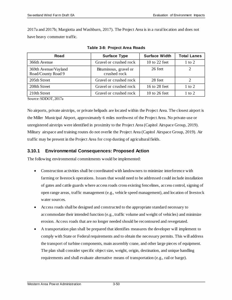
Sw eetland Wind Farm Draft EA Evaluation of Environment Impacts
Western Area Pow er Administration 3-50
2017a and 2017b; Margiotta and Washburn, 2017). The Project Area is in a rural location and does not
have heavy commuter traffic.
Table 3-8: Project Area Roads
Road Surface Type Surface Width Total Lanes 366th Avenue Gravel or crushed rock 10 to 22 feet 1 to 2 369th Avenue/Vayland Road/County Road 9
Bituminous, gravel or crushed rock
26 feet 2
205th Street Gravel or crushed rock 28 feet 2 208th Street Gravel or crushed rock 16 to 28 feet 1 to 2 210th Street Gravel or crushed rock 10 to 26 feet 1 to 2
Source: SDDOT, 2017a
No airports, private airstrips, or private helipads are located within the Project Area. The closest airport is
the Miller Municipal Airport, approximately 6 miles northwest of the Project Area. No private-use or
unregistered airstrips were identified in proximity to the Project Area (Capitol Airspace Group, 2019). Military airspace and training routes do not overlie the Project Area (Capitol Airspace Group, 2019). Air
traffic may be present in the Project Area for crop dusting of agricultural fields.
3.10.1 Environmental Consequences: Proposed Action The following environmental commitments would be implemented:
• Construction activities shall be coordinated with landowners to minimize interference with
farming or livestock operations. Issues that would need to be addressed could include installation
of gates and cattle guards where access roads cross existing fencelines, access control, signing of
open range areas, traffic management (e.g., vehicle speed management), and location of livestock water sources.
• Access roads shall be designed and constructed to the appropriate standard necessary to
accommodate their intended function (e.g., traffic volume and weight of vehicles) and minimize erosion. Access roads that are no longer needed should be recontoured and revegetated.
• A transportation plan shall be prepared that identifies measures the developer will implement to
comply with State or Federal requirements and to obtain the necessary permits. This will address
the transport of turbine components, main assembly crane, and other large pieces of equipment. The plan shall consider specific object size, weight, origin, destination, and unique handling
requirements and shall evaluate alternative means of transportation (e.g., rail or barge).

Sw eetland Wind Farm Draft EA Evaluation of Environment Impacts
Western Area Pow er Administration 3-51
• A traffic management plan shall be prepared for the site access roads to verify that no hazards
would result from increased truck traffic and that traffic flow would not be adversely impacted. This plan shall identify measures that will be implemented to comply with any State or Federal
Department of Transportation requirements, such as informational signs, flaggers when
equipment may result in blocked throughways, and traffic cones to identify any necessary
changes in temporary lane configurations. Signs shall be placed along roads to identify speed limits, travel restrictions, and other standard traffic control information.
• Project personnel and contractors shall be instructed and required to adhere to speed limits
commensurate with road types, traffic volumes, vehicle types, and site-specific conditions to ensure safe and efficient traffic flow.
• During construction, O&M, and decommissioning phases, traffic shall be restricted to designated
Project roads. Use of other unimproved roads shall be restricted to emergency situations.
Based on the proposed Project layout of wind turbines, access roads, underground collection lines, and associated facilities, no residences or businesses would be displaced due to construction of the Project. Up
to 356 acres of agricultural land would be temporarily impacted by Project construction (assuming all 80
wind turbine locations) for up to 12 months. Following construction, approximately 32 acres would be used for permanent operations of the Project and 324 acres would be returned to pre-construction land
uses, which primarily consist of cultivated croplands, hay, and pastureland. There would be some
improvements to gravel roads and temporary impacts to local roads during the construction phase of the
Project. Improvements could include adding gravel, widening, and repairing potholes. Sweetland would have a road haul agreement in place with Hand County to obtain the appropriate access and use permits,
and to minimize and mitigate the impacts to area transportation.
Project operation would have long-term impacts on up to 32 acres of agricultural land. Agricultural activities could occur up to the edge of access roads and turbine pads. Access roads and turbine pads
would not be fenced off except for gates/cattle guards installed in landowner fences. Livestock and the
landowners would be able to cross access roads and move about unimpeded. The buried underground
collection system would not alter agricultural activities in the long-term.
The Project would not result in any permanent impacts to the area’s ground transportation resources.
Also, air traffic generated by local and regional airports would not be impacted by the proposed Project.
Sweetland would follow FAA regulations for marking towers and would implement the necessary safety lighting. An ADLS would be installed on towers, if required by the FAA and/or SDPUC. Sweetland
submitted Form 7460-1, Notice of Proposed Construction or Alteration with the FAA for each turbine

Sw eetland Wind Farm Draft EA Evaluation of Environment Impacts
Western Area Pow er Administration 3-52
location in February 2017, assuming the GE 2.5/127 turbine with an 89-meter hub height option. The
FAA issued Determination of No Hazard for the preliminary layout. Since that time, the Project has been revised to a new turbine model, GE 2.82/127, with a 114-meter hub height. New Forms 7460-1 were filed
on February 14, 2019 for the new turbine array. Determinations of No Hazard would be obtained for the
finalized layout, and the Project would comply with applicable FAA requirements. As required, the
Developer would also file Tall Structures Aeronautical Hazard Applications with the South Dakota Aeronautics Commission for a permit approving the proposed wind turbine and permanent meteorological
tower locations.
Decommissioning impacts would be the same as those described for the construction phase.
3.10.2 Environmental Consequences: No Action Alternative The No Action Alternative would have no direct or indirect impacts on land uses and public facilities.
Existing activities, such as farming and the trend toward conversion of undeveloped land to agriculture,
would likely continue. These types of activities can impact land uses and public facilities.
3.11 Socioeconomics The PEIS describes 10 key measures of economic development: employment, unemployment, personal
income, State sales and income tax revenues, population, vacant rental housing, State and local
government expenditures and employment, and recreation. Table 3-9 lists the key measures of economic development applicable to the Project Area. Data is reported for Hand County and South Dakota for the
most recent year available. South Dakota does not currently have a State income tax, and, therefore, this
measure is not reported in the table. As can be seen in this table, median income in Hand County is
slightly lower than the median income in the State. The 2017 unemployment rate in Hand County (2.5 percent) was also lower than that of South Dakota (3.3 percent) (South Dakota Department of Labor and
Regulation, 2018).
Table 3-9: Key Measures of Economic Development
Economic Development Measures (Year) Hand County South Dakota Employment (2017)a 1,777 455,175 Unemployment rate (2017)a 2.5% 3.3% Median household income (2017)b $50,720 $54,126 State sales tax revenue (2017)c -- $2.0 billion Population (2017)d 3,277 869,666 Rental vacancy rate (2017)b 1.9% 5.4% State and local government expenditures (2012)e -- $6.9 million

Sw eetland Wind Farm Draft EA Evaluation of Environment Impacts
Western Area Pow er Administration 3-53
Economic Development Measures (Year) Hand County South Dakota State and local government employment (2016)b 205 65,727 State recreation sector income (2006)f -- $763 million
(a) South Dakota Department of Labor and Regulation, 2018 (b) U.S. Census Bureau, 2017a (c) South Dakota Department of Revenue, 2017 (d) U.S. Census Bureau, 2017b (e) U.S. Census Bureau, 2012 (f) WAPA and USFWS, 2015a
3.11.1 Environmental Consequences: Proposed Action Environmental commitments for air quality, noise, visual resources, and health and safety would apply to the Project Area. Separate socioeconomics environmental commitments are not identified.
The Project is expected to create both short-term and long-term positive impacts to the local economy.
Short-term impacts to social and economic resources would result from construction activities, and eventually from decommissioning activities at the end of the Project lifecycle. Local businesses, such as
restaurants, grocery stores, hotels, and gas stations, would see increased business from construction-
related workers. Local industrial businesses, including aggregate and cement suppliers, welding and
industrial suppliers, hardware stores, automotive and heavy equipment repair, electrical contractors, and maintenance providers, would also likely benefit from construction of the Project.
The Project would generate approximately $78.6 million in direct economic benefits for local landowners,
new local employees, local communities, and the State of South Dakota over the 35-year life of the Project, as outlined in Table 3-10. Additional benefits not shown in the table include local spending on
O&M needs such as automotive repair, tires, and gas.
Table 3-10:Direct Economic Benefit from the Sweetland Wind Farm
Payment Direct Beneficiary Approximate Totala Wind Lease payments Project landowners $21.0 million Operations and maintenance ~10 employees $22.5 million Taxes Townships, counties, school
districts, and South Dakota $35.1 million
(a) Assumes construction of an approximately 200 MW facility with 71 wind turbines and 35-year Project life.
Construction of the Project would require skilled labor, such as foremen, carpenters, iron workers, electricians, millwrights, and heavy equipment operators, as well as unskilled laborers. This diverse
workforce would be needed to install the Project components, including wind turbines, access roads,
underground collection line, O&M building, Project substation, etc. The Project is expected to employ

Sw eetland Wind Farm Draft EA Evaluation of Environment Impacts
Western Area Pow er Administration 3-54
approximately 200 temporary workers over approximately 12 months for approximately 400,000 to
420,000 worker-hours to support Project construction. The estimated number of construction jobs by classification and annual employment expenditures during construction are included in Table 3-11.
Table 3-11:Anticipated Construction Jobs and Employment Expenditures
Job Classification Number Estimated Annual Salary Crane operators 10 $90,000 Civil workers 30 $85,000
Construction managers 4 $110,000 Collection workers 25 $65,000
Tower erectors 35 $75,000 Transmission workers 30 $75,000
Substation workers 25 $80,000 Foundation workers 20 $70,000
Testing & inspections 13 $85,000 Design engineers 8 $140,000
Total: 200 $17,500,000
It is likely that general skilled labor is available in Hand County or the State to serve the basic infrastructure and site development needs of the Project. Specialized labor would be required for certain
components of Project construction, which may be imported from other areas. During construction, non-
local workers could need temporary housing, and the vacancy rate of rental properties in the commuting
radius of the Project could be reduced. However, anecdotal evidence indicates that construction workers would likely provide their own housing in recreational vehicle trailers. If needed, temporary housing for
workers would likely include available facilities at several towns throughout the area, with larger towns,
such as Miller, likely having more available facilities. The Project is not expected to have a negative effect on the economics of rental properties and could potentially have a positive effect.
The annual salary of construction workers is expected to be above the Hand County median household
income (see Table 3-11). However, since the number of construction jobs is less than 10 percent of the
county population and since the construction jobs are temporary, the Project is not expected to result in a material impact on median household income in the county.
The estimated number of jobs by classification and annual employment expenditures during operation are
included in Table 3-12. While the salary of some of the workers is likely to be greater than the median household income in Hand County, the small number of workers would not have a material effect on

Sw eetland Wind Farm Draft EA Evaluation of Environment Impacts
Western Area Pow er Administration 3-55
overall county median household income. Similarly, this small number of workers would not affect rental
vacancy levels.
Table 3-12:Anticipated Operation Jobs and Employment Expenditures
Job Classification Numbera Estimated Annual Salarya Turbine supplier site manager 1 $100,000
Turbine technicians 6 $52,000 Owner site manager 1 $115,000
Assistant site manager 1 $85,000 Administrative assistant 1 $31,200
Total: 10 $643,200 (a) For the first 10 years of commercial operation, in 1-year intervals.
Section 5.10 of the PEIS discusses potential impacts to property values from wind farm projects, indicating no evidence that wind turbines decreased property values. Hoen et al. (2013) concluded that
there was no statistical evidence that home values near turbines were affected either after construction or
after the site selection/project announcement.
Electricity transmission lines associated with wind developments can also potentially affect property
values through the visibility of electrical transmission structures. Other factors such as health and safety
and noise associated with a transmission system are likely less important. In a review of the evidence
from sales data and interviews with real estate professionals (Kroll and Priestley, 1992; Grover, Elliot, and Company, 2005), it was found that price differentials for residential properties based on sales data in
appraisal studies tended to be small, usually 5 percent or less, with slightly larger price impacts for
agricultural, commercial, and industrial land. It is anticipated that the proposed Project would have similar implications on property values in the Project Area to those described in the PEIS.
While the Project is expected to produce a net positive socioeconomic effect, there could be minor
negative effects such as increased maintenance on roads due to construction traffic. The period of
construction is relatively short in duration, and this effect is, therefore, expected to be minimal. Sweetland would have a road haul agreement in place with Hand County to obtain the appropriate access and use
permits, and to minimize and mitigate the impacts to area transportation.
3.11.2 Environmental Consequences: No Action Alternative The No Action Alternative would have no direct or indirect impacts on socioeconomics. Existing activities, such as farming and the trend toward conversion of undeveloped land to agriculture, would
likely continue. These types of activities can impact socioeconomics.
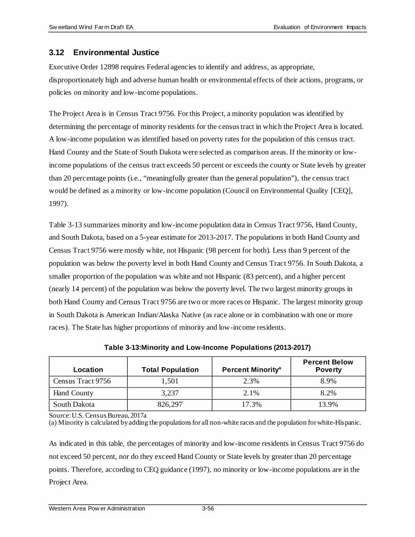
Sw eetland Wind Farm Draft EA Evaluation of Environment Impacts
Western Area Pow er Administration 3-56
3.12 Environmental Justice Executive Order 12898 requires Federal agencies to identify and address, as appropriate,
disproportionately high and adverse human health or environmental effects of their actions, programs, or policies on minority and low-income populations.
The Project Area is in Census Tract 9756. For this Project, a minority population was identified by
determining the percentage of minority residents for the census tract in which the Project Area is located. A low-income population was identified based on poverty rates for the population of this census tract.
Hand County and the State of South Dakota were selected as comparison areas. If the minority or low-
income populations of the census tract exceeds 50 percent or exceeds the county or State levels by greater
than 20 percentage points (i.e., “meaningfully greater than the general population”), the census tract would be defined as a minority or low-income population (Council on Environmental Quality [CEQ],
1997).
Table 3-13 summarizes minority and low-income population data in Census Tract 9756, Hand County, and South Dakota, based on a 5-year estimate for 2013-2017. The populations in both Hand County and
Census Tract 9756 were mostly white, not Hispanic (98 percent for both). Less than 9 percent of the
population was below the poverty level in both Hand County and Census Tract 9756. In South Dakota, a
smaller proportion of the population was white and not Hispanic (83 percent), and a higher percent (nearly 14 percent) of the population was below the poverty level. The two largest minority groups in
both Hand County and Census Tract 9756 are two or more races or Hispanic. The largest minority group
in South Dakota is American Indian/Alaska Native (as race alone or in combination with one or more races). The State has higher proportions of minority and low-income residents.
Table 3-13:Minority and Low-Income Populations (2013-2017)
Location Total Population Percent Minoritya Percent Below
Poverty Census Tract 9756 1,501 2.3% 8.9% Hand County 3,237 2.1% 8.2% South Dakota 826,297 17.3% 13.9%
Source: U.S. Census Bureau, 2017a (a) Minority is calculated by adding the populations for all non-white races and the population for white-Hispanic.
As indicated in this table, the percentages of minority and low-income residents in Census Tract 9756 do
not exceed 50 percent, nor do they exceed Hand County or State levels by greater than 20 percentage
points. Therefore, according to CEQ guidance (1997), no minority or low-income populations are in the Project Area.

Sw eetland Wind Farm Draft EA Evaluation of Environment Impacts
Western Area Pow er Administration 3-57
3.12.1 Environmental Consequences: Proposed Action Environmental commitments for air quality, noise, visual resources, and health and safety would apply to
the complete residential population in the Project Area, including any minority or low-income residents. Separate environmental justice environmental commitments are not identified.
No distinct minority or low-income populations have been identified in the Project Area, and, thus, no
disproportionately high and adverse human health or environmental effects are expected from construction, operation, or decommissioning of the proposed Project.
3.12.2 Environmental Consequences: No Action Alternative The No Action Alternative would have no direct or indirect impacts on environmental justice. Existing
activities, such as farming and the trend toward conversion of undeveloped land to agriculture, would likely continue, though these types of activities would not be expected to result in an environmental
justice impact.
3.13 Health and Safety The following sections describe electric and magnetic fields, noise and infrasound, shadow flicker, and
other hazards in the Project Area.
Electric and Magnetic Fields
Natural and man-made sources of electric and magnetic fields (EMFs) are commonplace in the United
States. Man-made sources include wind farms, substations, and power lines as well as ordinary household appliances such as hairdryers, electric shavers, computers, wireless networks, cell phones, microwaves,
and remote controls.
Electric fields exist wherever an electric charge exists. A magnetic field exists when that charge is in
motion (i.e., the flow of electrons to produce an electric current). EMFs are vector quantities, which means they have a strength and a specific direction. The strength of an EMF decreases substantially with
increasing distance from the source (National Institute of Environmental Health Sciences [NIEHS],
2018).
Potential health effects from EMF have been extensively studied (NIEHS, 1999; World Health
Organization, 2007). The studies found a weak correlation between EMF exposure and a slightly
increased risk of childhood leukemia. Studies that have been conducted on adults show no evidence of a
link between EMF exposure and adult cancers, such as leukemia, brain cancer, and breast cancer (NIEHS, 2018).

Sw eetland Wind Farm Draft EA Evaluation of Environment Impacts
Western Area Pow er Administration 3-58
There are currently no Federal or State regulations on maximum EMF intensity. However, the
International Commission on Non-ionizing Radiation Protection (ICNIRP) and the Institute of Electrical and Electronics Engineers (IEEE) have issued guidelines for exposure to EMF (ICNIRP, 1998; IEEE,
2002).
Noise and Infrasound
The affected environment for noise is discussed in Section 3.4.
In addition to generally audible noise (typically, frequencies of 20 to 20,000 Hertz) in the environment,
infrasound (sound with frequencies in the range of 1 to less than 20 Hertz) is commonplace in the United
States. Infrasound is created from natural sources, such as wind and any other natural motions that result in the slow oscillations of air, as well as man-made sources, such as cars, industrial machinery, slow-
moving fans, and other household appliances (Leventhall, 2003 and 2006). Infrasound is generally not
audible. However, infrasound can be audible at very high levels (110+ dBA), and these sounds may occur
from man-made but also natural sources, such as avalanches, ocean waves, meteors or volcanic eruptions (Bedard, 1999).
Because infrasound has many sources and because it can travel efficiently over long distances, its effects
on human health have been extensively studied. The studies have differing conclusions. However, expert testimony filed before the South Dakota Public Utilities Commission found that peer-reviewed, published
scientific research has not demonstrated a link between infrasound from wind turbines and adverse health
effects, including sleep disturbance or vertigo (Roberts, 2018).
The State of South Dakota has not independently studied or taken a formal position on the issue of wind turbines and human health effects. However, for the proposed Crocker Wind Farm in Clark County, the
South Dakota Secretary of Health submitted a letter to the South Dakota Public Utilities Commission
stating:
A number of state public health agencies have studied the issue, including the Massachusetts Department of Public Health and the Minnesota Department of Health. These studies generally conclude that there is insufficient evidence to establish a significant risk to human health. Annoyance and quality of life are the most common complaints associated with wind turbines, and the studies indicate that those issues may be minimized by incorporating best practices into the planning guidelines (Kim Malsam-Rysdon, 2017).
There currently are no regulations limiting infrasound exposure levels.

Sw eetland Wind Farm Draft EA Evaluation of Environment Impacts
Western Area Pow er Administration 3-59
Physical Hazards
The Project Area is subject to physical safety hazards typical of a rural agricultural area, such as storms and vehicle accidents. In addition, wind turbines can present physical safety hazards from a rotor blade
breaking and parts being thrown off or from ice buildup on a blade and the ice being thrown off. Both
blade throw and ice throw historically have rarely occurred.
3.13.1 Environmental Consequences: Proposed Action The following environmental commitments would be implemented:
• If Project operation could cause potential adverse impacts on nearby residences and occupied
buildings as a result of EMFs, incorporate recommendations for addressing these concerns into
the Project design (e.g., establishing a sufficient setback from transmission lines).
• Establish a process for documenting, investigating, evaluating, and resolving Project-related noise
complaints.
• For potential adverse impacts on nearby residences and occupied buildings as a result of noise, comply with county and state requirements for addressing these concerns into the Project design
(e.g., establishing a sufficient setback from transmission lines).
• Develop a Project health and safety program that addresses protection of public health and safety
during site characterization, construction, operation, maintenance, and decommissioning activities for a wind energy project. The program shall reference the Hand County Development
Agreement for setback for wind energy facilities as well as setback from associated transmission
lines from residences and occupied buildings, roads, ROWs, and other public access areas that is sufficient to limit accidents resulting from various hazards during all phases of development. It
shall identify requirements for temporary fencing around staging areas, storage yards, and
excavations during construction or decommissioning activities. It shall also identify measures to
be taken during the operations phase to limit public access to facilities (e.g., equipment with access doors shall be locked to limit public access, and permanent fencing with slats shall be
installed around electrical substations).
• Project developers shall work with appropriate agencies (e.g., Department of Energy and Transportation Security Administration) to address critical infrastructure and key resource
vulnerabilities at wind energy facilities, and to minimize and plan for potential risks from natural
events, sabotage, and terrorism.
The Project could potentially result in impacts associated with EMFs, noise and infrasound, shadow flicker, and physical hazards.

Sw eetland Wind Farm Draft EA Evaluation of Environment Impacts
Western Area Pow er Administration 3-60
Electric and Magnetic Fields
EMFs may exist within substations and switchyards of the wind farm and along the gen-tie line that would connect the facility to the grid. The substation and switchyard locations would be located on
private property and are not accessible to the general public; however, the public would have greater
accessibility to gen-tie line-related locations because some locations would be located on public ROWs or
accessible for agricultural uses. The EPA recommends limiting exposure to 0.5 milliGauss (mG) to 2.5
mG (EPA, 1992).
EMF levels decrease sharply with increasing distance. As Table 3-14 shows, the magnetic field of a
sample 230-kV transmission line decreases by 88 percent (from 57.5 to 7.1 mG) at 100 feet away from
the transmission line and by 97 percent (from 57.5 to 1.8 mG) 200 feet away from the transmission line.
Table 3-14:Example EMF Levels with Increasing Distance from a Power Transmission Line
Transmission Line Voltage
(kV)
Electric Field (kV)a Average Magnetic Field (mG)a
At the Source
100 Feet
Away
200 Feet Away
300 Feet Away
At the Source
100 Feet Away
200 Feet Away
300 Feet Away
230 2.0 0.3 0.05 0.01 57.5 7.1 1.8 0.8 Source: Bonneville Power Administration, 1994 (a) kV = kilovolt, mG = milligauss
The nearest occupied residence/building to the centerline of the permanent easement of the 230-kV gen-
tie line would be approximately 800 feet away; thus, the EMF exposure would be less than 0.5 mG at the closest residence, based on data extrapolated from Table 3-14. For comparison, Table 3-15 provides EMF
levels for common home appliances at distances up to 4 feet away.
Table 3-15:EMF Levels of Common Household Appliances
Appliance Average Magnetic Field (mG)a
Within 6 Inches 4 Feet Away Blender 30-100 0
Dishwasher 10-100 0-1 Microwave Oven 100-300 0-20
Electric Range 20-200 0-6 Refrigerator 0-40 0-10
Vacuum Cleaner 100-700 0-10 Source: EPA, 1992 (a) mG = milligauss

Sw eetland Wind Farm Draft EA Evaluation of Environment Impacts
Western Area Pow er Administration 3-61
Project operation would create EMFs. However, at present, there is no scientific consensus regarding a
cause-effect relationship between continued exposure to EMFs and adverse health consequences. Furthermore, Sweetland has incorporated setback requirements and commitments into the design of the
Project in compliance with State requirements, the Hand County Development Agreement (Appendix C),
and the turbine manufacturer’s (GE) recommendations. Furthermore, the EMF exposure is expected to be
less than that generated by many common household appliances (see Table 3-15) and below the midpoint of the EPA recommendations.
Noise and Infrasound
Potential impacts associated with noise are discussed in Section 3.4.
In addition to audible noise, wind turbines can generate infrasound from the rotation of the turbine blades.
The infrasound levels from contemporary wind turbines are lower than those that have been shown to
cause harm, such as the high-intensity infrasound aircraft maintenance workers encounter (Roberts,
2018).
Project construction and decommissioning activities would not generate infrasound because the turbine
blades would not be moving. Project operation would create infrasound, however.
Human health effects sometimes attributed to wind farm noise and infrasound include sleep disturbance, vertigo, and stress. However, reliable evidence has not provided a link between infrasound and these
adverse health effects. An independent expert panel for Massachusetts (Ellenbogen et al., 2012) found
insufficient evidence that the noise from wind turbines is directly causing human health effects. Instead,
studies have linked the experience of adverse human health effects to individual perceptions and attitudes about wind farms. Thus, while studies have not reliably shown that wind farms cause direct health effects,
negative attitudes about wind farms have been correlated with health effects such as sleep disturbance
(Ellenbogen et al., 2012).
Physical Hazards
As with any wind farm, the Project would present potential risks from natural disasters (earthquakes,
storms, etc.), mechanical failure, human error, sabotage, cyber-attack, or deliberate destructive acts. The
Project would not present unusual intrinsic system vulnerabilities or especially high potential for an event/threat. Thus, the proposed Project is not anticipated to be at an unusual risk for natural disasters,
mechanical accidents, or acts of sabotage or terrorism during Project construction, operation, or
decommissioning.

Sw eetland Wind Farm Draft EA Evaluation of Environment Impacts
Western Area Pow er Administration 3-62
Project wind turbines could potentially have a rotor blade break and be thrown from the turbine.
Historically, blade breakage is a rare event, and the probability of a fragment hitting a person is even lower (Manwell et al., 2002; Hau, 2000). A blade or turbine part has rarely traveled farther than 1,640 feet
from a tower; most pieces typically land within 328 to 656 feet (Manwell et al., 2002). Current quality
control standards for utility-scale wind turbine manufacture suggest that blade throw will continue to be a
rare occurrence.
Project wind turbines also could potentially throw ice from a rotating blade. Historically, ice throw is a
rare event because either ice pieces simply fall down off a blade or turbine control software triggers a
turbine to stop rotating if ice buildup occurs. Contemporary turbine design limits the extent to which ice buildup can occur because as ice begins to form, blade balance would be altered, and monitoring devices
would stop the blade rotation. Thus, ice throw also will likely continue to be a rare occurrence. To further
lessen the potential for ice throw, wind farms establish a safety zone or setback from residences, roads,
and other public access areas; such safety zones are often required by permitting agencies (Manwell et al., 2002). The suggested setback for the turbine model proposed for the Project, which will include turbine
control software to control for ice throw, is 1.1 times the sum of the hub height and rotor diameter (GE
Renewable Energy, 2018).
Project construction and decommissioning activities would not generate risk from rotor blade break or ice
throw because the turbine blades would not be moving.
3.13.2 Environmental Consequences: No Action Alternative The No Action Alternative would have no direct or indirect impacts on health and safety. Existing activities, such as farming and the trend toward conversion of undeveloped land to agriculture, would
likely continue. These types of activities can impact health and safety.

Sw eetland Wind Farm Draft EA Cumulative Impacts
Western Area Pow er Administration 4-1
4.0 CUMULATIVE IMPACTS
The cumulative impacts of past, present, and future actions on resources within the UGP Region are
analyzed in Section 6 of the PEIS. The contribution of cumulative impacts associated with the proposed Project falls within the scope of the cumulative impacts analysis in the PEIS.
No other operating energy conversion facilities, existing or under construction, are within or adjacent to
the Project Area. The 25-MW Titan Wind Project is the only other wind facility in Hand County; it is located approximately 12 miles from the Project. No other commercial scale wind projects are currently
being leased and/or permitted in Hand County or are reasonably foreseeable. The next closest wind
energy conversion facilities are the Wessington Springs Wind Project in Jerauld County located 24 miles
southeast of the Project and the Prairie Winds Wind Project in Jerauld, Aurora and Brule counties, located 30 miles south of the Project. The existing Highmore Wind Energy Project in Hyde County is
approximately 27 miles from the Project. The Triple H Wind Project in Hyde County is currently under
construction.
The construction and operation of the proposed Project, in combination with operation of the existing
Titan Wind Project, as well as other private and public development occurring in the Project Area, would
contribute to cumulative impacts on resources within the UGP Region. Such impacts would be similar to
those described in the PEIS. A summary of cumulative impacts analyzed for each resource area under the PEIS’s preferred alternative (of which this Project is a part) is provided in Table 6.3-2 of the PEIS. Table
4-1 summarizes potential cumulative effects associated with the Project.
With the implementation of environmental commitments, the Project would avoid or reduce impacts to the resources described above and are not expected to measurably contribute to cumulative effects on
resources from other past, present, and reasonably foreseeable future actions.

Sw eetland Wind Farm Draft EA Cumulative Impacts
Western Area Pow er Administration 4-2
Table 4-1: Discussion of Cumulative Effects
Resources that Could Experience
Cumulative Effects
Related Past, Present, and Reasonably Foreseeable
Activities Discussion of Potential Cumulative
Effects No Action Alternative None • Roads and highways
• Electric transmission and distribution lines
• Titan Wind Project • Cultivated land • Developed land • Residences and other buildings • Grazing • Hunting
The No Action Alternative would not contribute to cumulative effects
Proposed Alternative Noise • Roads and highways
• Farm operations • Titan Wind Project
The Project would contribute to the incremental increase of noise in the Project Area.
Ecological Resources, Land Use, Land Cover
• Roads and highways • Electric transmission and
distribution lines • Titan Wind Project • Cultivated land • Developed land • Residences and other buildings • Grazing • Hunting
Impacts to ecological resources, land use, and land cover have occurred in this area for more than two centuries. The addition of the proposed Project would contribute to this trend.
Visual Resources • Titan Wind Project • Electric transmission and
distribution lines • Residences and other buildings • Roads and highways
The visual landscape has been continually altered for more than two centuries. The current viewshed is one of a “working” landscape with man-made alterations as prominent features. The addition of the proposed Project would increase the number of man-made structures in the viewshed.

Sw eetland Wind Farm Draft EA Coordination
Western Area Pow er Administration 5-1
5.0 COORDINATION
A public scoping meeting was held on August 7, 2018, in Miller, South Dakota. Federal, State, and local
agencies were invited to the meeting to provide comments regarding the proposed Project. The general public was invited through newspaper announcements, and residents near the Project were invited to
comment. The public scoping meeting documentation is included in Appendix P. Comments received
regarding the proposed Project from agencies and the public are included in Appendix Q.
5.1 Federal Agencies The Federal agencies that were contacted for the purpose of the EA scoping process are:
• Advisory Council on Historic
Preservation
• Bureau of Indian Affairs, Great Plains
Regional Office
• Bureau of Land Management, South
Dakota Field Office
• FEMA, Region VIII
• Federal Energy Regulatory
Commission, Office of Energy Projects
• Federal Highway Administration, South
Dakota Division
• USACE, South Dakota Regulatory
Office
• U.S. Department of Agriculture, NRCS,
South Dakota State Office
• U.S. Department of Agriculture, Rural
Utilities Service, Water and Environmental Program
• U.S. Department of Agriculture, South
Dakota State Farm Service Agency
• U.S. Department of Transportation, FAA, Great Lakes Region
• EPA, Region 8
• USFWS, Huron Wetland Management District
• USFWS, South Dakota Field Office
• USGS, Midwest Region
• U.S. House of Representatives
• U.S. Senate
5.2 State and Local Agencies The State and local agencies that were contacted for the purpose of the EA scoping process are:
• Governor's Office of Economic
Development
• Hand County
• Hand County Board of Commissioners
• Hand County Conservation District
• Miller School District
• SDDOA
• SDDENR, Division of Environmental Services
• SDDOT, Aberdeen Region
Sw eetland Wind Farm Draft EA Coordination
Western Area Pow er Administration 5-2
• South Dakota Department of Tribal
Relations
• SDGFP
• South Dakota House of Representatives,
District 23
• South Dakota Office of the Governor
• SDPUC
• South Dakota School and Public Lands
• South Dakota Senate, District 23
• South Dakota SHPO
• Wosley-Wessington School District
5.3 Native American Tribes and Associated Bodies Pursuant to Section 106 of the NHPA, WAPA initiated tribal consultations, by letter, regarding the
proposed Project with the following eight tribes on August 3, 2018:
• Apache Tribe of Oklahoma
• Cheyenne and Arapaho Tribes
• Cheyenne River Sioux Tribe
• Crow Creek Sioux Tribe
• Fort Belknap Indian Community
• Lower Brule Sioux Tribe
• Standing Rock Sioux Tribe
• Yankton Sioux Tribe.
WAPA received several tribal responses. The Crow Creek Sioux Tribe requested to participate in the
cultural resource surveys. The Cheyenne and Arapaho Tribes responded that the Project was determined
to be categorized as “no adverse effect,” and requested that if Project changes significantly alter the current APE, or if inadvertent discoveries are made that reflect additional evidence of TCP, the Project
should promptly cease work and notify the Cheyenne and Arapaho Tribal Historic Preservation Office
within 72 hours. The Yankton Sioux Tribe indicated sites of cultural significance or historic properties would potentially be affected by the Project and asked that the area be surveyed and monitored before and
during construction of the Project. Both the Crow Creek Sioux and Yankton Sioux tribes participated in
cultural resource surveys during October 2018 and May 2019 (Section 3.9).
5.4 Non-Governmental Organizations Non-governmental organizations have been contacted to participate in the EA scoping process. The non-governmental organizations that were contacted for the purpose of the EA scoping process are:
• American Bird Conservancy

Sw eetland Wind Farm Draft EA Coordination
Western Area Pow er Administration 5-2
• Ducks Unlimited, Great Plains Regional Office
• Izaak Walton League of America, South Dakota Division
• Missouri Breaks Audubon Society
• Pheasants Forever, Inc.
• Sierra Club, South Dakota Chapter
• The Nature Conservancy, Minnesota-North Dakota-South Dakota Field Office

Sw eetland Wind Farm Draft EA List of Preparers
Western Area Pow er Administration 6-1
6.0 LIST OF PREPARERS
Table 6-1 identifies the personnel responsible for the preparation of this EA.
Table 6-1: List of EA Preparers
Name Agency/Firm Title Christina Gomer WAPA NEPA Coordinator
(Natural Resources Specialist) Alyssa Fellow WAPA Biologist David Kluth WAPA Archeologist Matthew Marsh WAPA Environmental Manager Mark Wengierski Sweetland Senior Project Manager Pat Landess Sweetland Associate Project Manager Paul Callahan Burns & McDonnell Senior NEPA Specialist Carrie Barton Burns & McDonnell Senior Environmental Scientist Angelina Woehler Burns & McDonnell Environmental Scientist

Sw eetland Wind Farm Draft EA References
Western Area Pow er Administration 7-1
7.0 REFERENCES
Avian Power Line Interaction Committee (APLIC). (2006). Suggested Practices for Avian Protection on Power Lines: The State of the Art in 2006, Edison Electric Institute, APLIC, and the California Energy Commission, Washington, D.C., and Sacramento, Calif. Accessed November 11, 2018 from https://www.nrc.gov/docs/ML1224/ML12243A391.pdf.
APLIC. (2012). Reducing Avian Collisions with Power Lines: The State of the Art in 2012. Edison Electric Institute and APLIC. Washington, D.C.
Bat Conservation International, Inc. (BCI). (2018). Species Profiles: Myotis septentrionalis. Northern long-eared myotis. Accessed September 2018 from http://www.batcon.org/resources/media-education/species-profiles/detail/2306.
Bauman, P., B. Carlson, and T. Butler. (2013). Quantifying Undisturbed (Native) Lands in Eastern South Dakota: 2013. Natural Resource Management Data Sets. Department of Natural Resource Management. South Dakota State University. Available at: http://openprairie.sdstate.edu/data_land-easternSD/1/.
Bedard, Jr., Alfred J. (1999). Naturally occurring sources of infrasound. The Journal of the Acoustical Society of America 105:2, 1103-1103. 25 January 1999.
Bonneville Power Administration. (1994). Electric Power Lines: Questions and Answers on Research into Health Effects, Portland, Oregon: U.S. Department of Energy.
Burns & McDonnell. (2019). Sweetland Wind Project Wetland Delineation Report. Prepared for Sweetland Wind Farm, LLC.
Capitol Airspace Group. (2019). Obstruction Evaluation & Airspace Analysis, Sweetland Wind Project, Hand County, South Dakota. Prepared for Scout Clean Energy.
Council on Environmental Quality. (1997). Environmental Justice Guidance Under the National Environmental Policy Act. Accessed November 12, 2018 from https://ceq.doe.gov/docs/ceq-regulations-and-guidance/regs/ej/justice.pdf.
Chadima, S. (1994). South Dakota Aquifers. South Dakota Geological Survey. Accessed September 2018 from http://www3.northern.edu/natsource/EARTH/Aquife1.htm.
Derby, C., A. Dahl, A. Merrill, and K. Bay. (2010). 2009 Post-Construction Monitoring Results for the Wessington Springs Wind-Energy Facility, South Dakota. Final Report. Prepared for Wessington Wind Energy Center, LLC, Juno Beach, Florida. Prepared by Western EcoSystems Technology, Inc. (WEST), Bismarck, North Dakota. August 19, 2010
Derby, C., A. Dahl, K. Bay, and L. McManus. (2011). 2010 Post-Construction Monitoring Results for the Wessington Springs Wind Energy Facility, South Dakota. Final Report: March 9 – November 16, 2010. Prepared for Wessington Wind Energy Center, LLC, Juno Beach, Florida. Prepared by Western EcoSystems Technology, Inc. (WEST), Bismarck, North Dakota. November 22, 2011
Derby, C., K. Chodachek, T. Thorn, and A. Merrill. (2012). Post-Construction Surveys for the Prairiewinds ND1 (2011) Wind Facility Basin Electric Power Cooperative: March - October

Sw eetland Wind Farm Draft EA References
Western Area Pow er Administration 7-2
2011. Prepared for Basin Electric Power Cooperative, Bismarck, North Dakota. Prepared by Western EcoSystems Technology, Inc. (WEST), Bismarck, North Dakota. August 31, 2012
Derby, C., A. Dahl, and D. Fox. (2013). Post-Construction Fatality Monitoring Studies for the Prairiewinds SD1 Wind Energy Facility, South Dakota. Final Report: March 2012 - February 2013. Prepared for Basin Electric Power Cooperative, Bismarck, North Dakota. Prepared by Western EcoSystems Technology, Inc. (WEST), Bismarck, North Dakota. November 13, 2013.
Egan, D.M. (1988.) Architectural Acoustics. McGraw-Hill. 411 pp.
Ellenbogen, J.M., S. Grace, W.J. Heiger-Bernays, J.F. Manwell, D.A. Mills, K.A. Sullivan, and M.G. Weisskopf. (2012). Wind Turbine Health Impact Study: Report of Independent Expert Panel. Prepared for Massachusetts Department of Environmental Protection, Massachusetts Department of Public Health.
U.S. Environmental Protection Agency (EPA). (1992). EMF in Your Environment. Accessed January 4, 2019 from https://nepis.epa.gov/Exe/ZyPDF.cgi/000005EP.PDF?Dockey=000005EP.PDF.
EPA. (2017a). Air Data Air Quality Monitors. Accessed January 8, 2018 from https://www3.epa.gov/airdata/ad_maps.html.
EPA. (2017b). Greenhouse Gas Emissions, last updated February 22, 2017. Accessed November 11, 2018 from http://www.epa.gov/climatechange/emissions/index.html.
EPA. (2018). Current Nonattainment Counties for All Criteria Pollutants. Accessed January 5, 2018 from https://www3.epa.gov/airquality/greenbook/ancl.html.
Epsilon Associates, Inc. (2019). Sound Level Assessment Report, Sweetland Wind Project, Hand County, South Dakota. Prepared for Scout Clean Energy.
Erickson, W. P., M. M. Wolfe, K. J. Bay, D. H. Johnson, and J. L. Gehring. (2014.) A Comprehensive Analysis of Small Passerine Fatalities from Collisions with Turbines at Wind Energy Facilities. PLoS ONE 9(9): e107491. doi: 10.1371/journal.pone.0107491.
Federal Emergency Management Agency. (2017). FEMA Flood Map Service Center: Search by Address. Retrieved 13 November 2018 from: https://msc.fema.gov/portal/search.
GE Renewable Energy. (2018). General Description, Setback Considerations for Wind Turbine Siting. Technical Documentation Wind Turbine Generator Systems, All Onshore Turbine Types. Provided to Sweetland Wind Farm, LLC.
Grover, Elliot and Company, (2005). A Report of the Effect of the Vancouver Island Transmission Line, BCTC Project No. 3698395, on the Value of Real Property Adjacent to, and Containing, the Right-of-Way Situated between Arnott Substation in Delta to Vancouver Island Terminal in North Cowichan, All in British Columbia.
Harris, B., C. Ewers, D. Kullen, J. Kepka, and A. Javers. (2019). Historic-Age Resource Reconnaissance Survey for the Sweetland Wind Farm, Beadle and Hand Counties, South Dakota. Prepared for Sweetland Wind Farm, LLC. Burns & McDonnell Engineering Company, Inc.
Sw eetland Wind Farm Draft EA References
Western Area Pow er Administration 7-3
Hau, E. (2000). Windturbines: Fundamentals, Technologies, Application, Economics, Springer-Verlag, Berlin, Germany.
Hoen B., J.P. Brown, T. Jackson, R. Wiser, M. Thayer, and P. Cappers. (2013). A Spatial Hedonic Analysis of the Effects of Wind Energy Facilities on Surrounding Property Values in the United States. Office of Energy Efficiency and Renewable Energy. U.S. Department of Energy. 58 pp.
Homer, C. G., J. Dewitz, L. Yang, S. Jin, P. Danielson, G. Z. Xian, J. Coulston, N. Herold, J. Wickham, and K. Megown. (2015). Completion of the 2011 National Land Cover Database for the conterminous United States–Representing a decade of land cover change information. Photogrammetric Engineering and Remote Sensing 81:345‒354.
International Commission on Non-Ionizing Radiation Protection (ICNIRP). (1998). Guidelines for Limiting Exposure to Time-Varying Electric, Magnetic, and Electromagnetic Fields (up to 300 GHz), Health Phys. 74(4):494–522.
Institute of Electrical and Electronics Engineers (IEEE). (2002). IEEE Standard for Safety Levels with Respect to Human Exposure to Electromagnetic Fields 0–3 kHz, Standards Coordinating Committee 28, New York, NY.
Jalkotzy, M.G., P.I. Ross, and M.D. Nasserden. (1997). The effects of linear developments on wildlife: a review of selected scientific literature. Arc Wildlife Services Ltd, prepared for Canadian Association of Petroleum Producers, Calgary
Johnson, G., and M. Holloran. (2010). Greater Sage-Grouse and Wind Energy Development: A Review of the Issues. Prepared for Renewable Northwest Project, Portland, Oregon. Prepared by Western EcoSystems Technology, Inc. (WEST), Cheyenne, Wyoming. April 14, 2010.
Johnson R.R., Granfors D.A., Niemuth N.D., Estey M.E., Reynolds R.E. (2010). Delineating Grassland Bird Conservation Areas in the U.S. Prairie Pothole Region. Journal of Fish and Wildlife Management 1(1):38–42; e1944-687X. doi: 10.3996/JFWM-022
Kroll, C., and T. Priestley. (1992). The Effects of Overhead Transmission Lines on Property Values: A Review and Analysis of the Literature, Edison Electric Institute Siting and Environmental Analysis Planning Task Force, Washington, DC. Accessed March 2009 from http://staff.haas.berkeley.edu/kroll/pubs/tranline.pdf.
Lee, J.M., K.S. Pierce, C.A. Spiering, R.D. Stearns, and G. VanGinhoven. (December 1996). Electrical and Biological Effects of Transmission Lines: A Review,” Bonneville Power Administration, Portland, OR.
Lehmkuhl, John F. and Leonard F. Ruggiero. (1991). Forest Fragmentation in the Pacific Northwest and its Potential Effects on Wildlife. Wildlife and Vegetation of Unmanaged Douglas-Fir Forests, General Technical Report PNW-GTR-285. Accessed September 19, 2019, at https://www.fs.fed.us/pnw/pubs/gtr285/
Leventhall, G. (2003). A Review of Published Research on Low Frequency Noise and Its Effects, prepared for the Department for Environment, Food, and Rural Affairs, London, UK.

Sw eetland Wind Farm Draft EA References
Western Area Pow er Administration 7-4
Leventhall, G. (2006). What Is Infrasound?, Progress in Biophysics and Molecular Biology 93(1-3):130–137, Epub 2006, Aug. 4. Accessed November 12, 2018 from http://www.ncbi.nlm.nih.gov/pubmed/ 16934315.
Lincoln, F.C., S.R. Peterson, and J.L. Zimmerman. (1998). Migration of Birds, U.S. Fish and Wildlife Service Circular 16, U.S. Department of the Interior, Washington, DC. Accessed November 12, 2018 from https://www.csu.edu/cerc/researchreports/documents/MigrationofBirdsCircular.pdf.
Loesch, Charles R., J.A. Walker, R.E. Reynolds, J.S. Gleason, N.D. Niemuth, S.E. Stephens, and M.A. Erickson. (2013). Effect of Wind Energy Development on Breeding Duck Densities in the Prairie Pothole Region. The Journal of Wildlife Management 77(3): 587-598. DOI
Mabee, Todd. (2019). Personal communication from Todd Mabee at Western EcoSystems Technology, Inc. (WEST) to Carrie Barton, Burns & McDonnell Engineering Company, Inc. June 11.
Malsam-Rysdon, K. (2017). In the Matter of the Application by Crocker Wind Farm, LLC for a Permit of a Wind Energy Facility and a 345 kV Transmission Line in Clark County, South Dakota, for a Crocker Wind Farm, Docket No. EL 17-055. Accessed December 29, 2018 at https://puc.sd.gov/commission/dockets/electric/2018/EL18-003/exhibits/dakotarange/ExhibitA2-8.PDF.
Manwell, J.F., J.G. McGowan, and A.L. Rogers. (2002). Wind Energy Explained: Theory, Design, and Application, John Wiley & Sons, Ltd., Chichester, UK.
Margiotta, Richard and Scott Washburn. (2017). Simplified Highway Capacity Calculation Method for the Highway Performance Monitoring System, Federal Highway Administration Office of Policy and Governmental Affairs. Accessed June 12, 2019, from https://www.fhwa.dot.gov/policyinformation/pubs/pl18003/hpms_cap.pdf
Minnesota Department of Natural Resources/U.S. Fish and Wildlife Survey. (2018). Townships Containing Documented Northern Long-Eared Bat (NLEB) Maternity Roost Trees and/or Hibernacula Entrances in Minnesota. Accessed from http://files.dnr.state.mn.us/eco/ereview/minnesota_nleb_township_list_and_map.pdf
Multi-Resolution Land Characteristics Consortium (MRLC). (2011). National land cover database 2011: Product legend. Accessed May 2018 from http://www.mrlc.gov/nlcd11_leg.php.
National Audubon Society. (2019). Important Bird Areas: South Dakota. Accessed April 23, 2019 from https://www.audubon.org/important-bird-areas/state/south-dakota.
National Institute of Environmental Health Sciences (NIEHS). (1999). NIEHS Report on Health Effects from Exposure to Power Line Frequency and Electric and Magnetic Fields, Publication No. 99-4493, Research Triangle Park, NC. Accessed November 12, 2018 from https://www.niehs.nih.gov/health/assets/docs_p_z/report_powerline_electric_mg_predates_508.pdf.
NIEHS. (2018). Electric & Magnetic Fields. Accessed October 31, 2018 from https://www.niehs.nih.gov/health/topics/agents/emf/index.cfm.
Natural Resources Conservation Service (NRCS). (2018). Web Soil Survey. Accessed January 2018 from https://websoilsurvey.sc.egov.usda.gov/App/HomePage.htm.

Sw eetland Wind Farm Draft EA References
Western Area Pow er Administration 7-5
Pearse, A.T., D.A. Brandt, W.C. Harrell, K.L. Metzger, D.M. Baasch, and T.J. Hefley. (2015). Whooping crane stopover site use intensity within the Great Plains: U.S. Geological Survey Open-File Report 2015–1166, 12 p. Accessed from http://dx.doi. org/10.3133/ofr20151166.
Pearse, A. T., M. Rabbe, M. T. Bidwell, L. M. Juliusson, L. Craig-Moore, D. A. Brandt, and W. Harrell. (2018). Map of Whooping Crane Migration Corridor: U.S. Geological Survey Data Release. Available online: https://www.sciencebase.gov/catalog/item/5a314a72e4b08e6a89d707e0
Ramsey, C.G., H.R. Sleeper, and J.R. Hoke. (1994). Architectural Graphic Standards, 9th edition. American Institute of Architects. J. Wiley. 918 pp.
Roberts, M.M. (2018). Pre-Filed Supplemental Direct Testimony of Dr. Mark Roberts on Behalf of Prevailing Wind Park, LLC. SD PUC DOCKET EL18-026.
Shaffer, J. A. and D. A. Buhl. (2016). Effects of wind-energy facilities on breeding grassland bird distributions. Conservation Biology 30(1):59-71.
Shaver, Douglas. (2019a). A Level III Intensive Cultural Resources Survey for the Sweetland Wind Project, Hand County, South Dakota. Prepared for Sweetland Wind Farm, LLC. Burns & McDonnell Engineering Company, Inc.
Shaver, Douglas. (2019b). Addendum - A Level III Intensive Cultural Resources Survey for the Sweetland Wind Project, Hand County, South Dakota. Prepared for Sweetland Wind Farm, LLC. Burns & McDonnell Engineering Company, Inc.
South Dakota Department of Agriculture (SDDOA). (2017a). State Noxious Weed & Pest List. Retrieved 13 November 2018 from: https://sdda.sd.gov/ag-services/weed-and-pest-control/weed-pestcontrol/sd-state-noxious-weed-declared-pest-list-and-distribution-maps/default.aspx.
SDDOA. (2017b). County Noxious Weed & Pest List. Retrieved 13 November 2018 from: https://sdda.sd.gov/ag-services/weed-and-pest-control/weed-pest-control/county-noxious-weedpest-list-and-distribution-maps/default.aspx.
South Dakota Department of Labor and Regulation. (2018). Labor Force, Employment and Unemployment for South Dakota in 2017. Accessed 14 November 2018 from http://dlr.sd.gov/.
South Dakota Department of Revenue. (2017). 2017 Annual Report. Accessed July 2018 from https://dor.sd.gov/Publications/Annual_Reports/PDFs/Print-Annual-optimized.pdf.
South Dakota Department of Transportation (SDDOT). (2017a). Map Viewer and Data Download. Retrieved 14 November 2018 from: http://sdbit.maps.arcgis.com/apps/webappviewer/index.html?id=93bd565a70a94f138f90ceed29ce1b12.
SDDOT. (2017b). 2017 Statewide Traffic Flow Map. Retrieved 15 November 2018 from: http://www.sddot.com/transportation/highways/traffic/Default.aspx.
South Dakota Game, Fish and Parks (SDGFP). (2014). South Dakota Wildlife Action Plan. Available online: http://gfp.sd.gov/images/WebMaps/Viewer/WAP/Website/PlanSections/SD%20Wildlife%20Act on%20Plan%20Revision%20Final.pdf.
Sw eetland Wind Farm Draft EA References
Western Area Pow er Administration 7-6
SDGFP. (2018). Natural Heritage Program Data. Retrieved from: https://gfp.sd.gov/forms/heritagedata
U.S. Census Bureau. (2012). 2012 Census of Governments: State and Local Finances. Accessed 14 November 2018 from http://www.census.gov/govs/local.
U.S. Census Bureau. (2017a). 2013-2017 American community survey 5-year estimates. Accessed 14 November 2018 from http://factfinder.census.gov.
U.S. Census Bureau. (2017b). 2017 Population Estimates. Retrieved 14 November 2018 from: http://factfinder.census.gov.
U.S. Fish and Wildlife Service (USFWS). (2008). Birds of Conservation Concern 2008. Division of Migratory Bird Management, Arlington, VA. Accessed April 23, 2019 from http://digitalmedia.fws.gov/cdm/singleitem/collection/document/id/1249/rec/1.
USFWS. (2012). Comprehensive conservation plan: Huron Wetland Management District, Madison Wetland Management District, and Sand Lake Wetland Management District, South Dakota. Lakewood, CO: U.S. Department of the Interior, U.S. Fish and Wildlife Service. 260 p. Accessed September 17, 2019 from https://www.fws.gov/mountain-prairie/refuges/completedPlanPDFs_F-L/hur_mad_sdl_ccp_all.pdf
USFWS. (2016). Waterfowl Population Status, 2016. Division of Migratory Bird Management. Retrieved online February 21, 2019, from: https://www.fws.gov/migratorybirds/pdf/surveys-and-data/Population-status/Waterfowl/WaterfowlPopulationStatusReport16.pdf
USFWS. (2017). Cooperative Whooping Crane Tracking Project (CWCTP) GIS Database (CWCTP-GIS). Whooping Crane Incidental Observations through Spring 2017. GIS layer from CWCTP, U.S. Fish and Wildlife Service (USFWS), Grand Island, Nebraska.
USFWS. (2018a). Information for Planning and Consultation (IPaC). IPaC, Environmental Conservation Online System (ECOS). Retrieved online December 19, 2018 from: https://ecos.fws.gov/ipac/.
USFWS. (2018b). Range-Wide Indiana Bat Summer Survey Guidelines. Available online: https://www.fws.gov/midwest/endangered/mammals/inba/surveys/pdf/2018RangewideIBatSurveyGuidelines.pdf.
U.S. Geological Survey (USGS). (2017). Earthquake Hazards Program, Simplified 2017 Hazard Map (PGA, 2% in 50 Years). Accessed January 2018 from http://earthquake.usgs.gov/hazards/products/conterminous/index.php#2014.
USGS. (2018). Water Resources: StreamStats. Retrieved online December 18, 2018 from: https://www.usgs.gov/mission-areas/water-resources/science/streamstats?qt-science_center_objects=0#qt-science_center_objects
Western Area Power Administration (WAPA) and U.S. Fish and Wildlife Service (USFWS). (2015a). Upper Great Plains Wind Energy Programmatic Environmental Impact Statement – Final. Accessed April 2018 from https://www.wapa.gov/regions/UGP/Environment/Pages/ugp-nepa.aspx.

Sw eetland Wind Farm Draft EA References
Western Area Pow er Administration 7-7
WAPA and USFWS. (2015b). Programmatic biological assessment for the Upper Great Plains Region wind energy program – final. Accessed April 2018 from https://www.wapa.gov/regions/UGP/Environment/Pages/ugp-nepa.aspx.
World Health Organization. (2007). Extremely Low Frequency Fields, Environmental Health Criteria 238, WHO Press, Geneva, Switzerland.

APPENDIX A – WIND TURBINE AND TRANSMISSION FACILITY DIAGRAMS

APPENDIX B – WETLAND DELINEATION REPORT

APPENDIX C – HAND COUNTY DEVELOPMENT AGREEMENT

APPENDIX D – SOUND STUDY
APPENDIX E – NATIVE GRASSLANDS HABITAT REPORT
APPENDIX F – EAGLE AND RAPTOR NEST SURVEYS
APPENDIX G – AVIAN USE SURVEYS

APPENDIX H – ACOUSTIC BAT SURVEYS
APPENDIX I – BIRD AND BAT CONSERVATION STRATEGY

APPENDIX J – PRESENCE/ABSENCE SURVEYS FOR NORTHERN LONG-EARED BAT

APPENDIX K – WHOOPING CRANE HABITAT REVIEW

APPENDIX L – CONSISTENCY EVALUATION FORMS

APPENDIX M – WHOOPING CRANE MONITORING PLAN AND SHUT-DOWN PROTOCOL

APPENDIX N – SHADOW FLICKER REPORT

APPENDIX O – CULTURAL RESOURCES REPORTS

APPENDIX P – SCOPING MEETING INFORMATION

APPENDIX Q – AGENCY CORRESPONDENCE AND PUBLIC COMMENTS