swords - fingal county council
TRANSCRIPT
SwordsMasterplansMay 2019
Part E: Appendices
www.fingal.ie

Appendix APolicy Context
Appendix B Residential Typologies Study
Appendix C Stormwater Management Plan Part 1: Strategic Flood Risk Assessment & Part 2: Sustainable Drainage Systems (SuDS) Strategy
Appendix D Strategic Environmental Assessment (SEA) and Appropriate Assessment (AA)
Appendix E Natura Impact Statement (NIS)

Appendix APolicy Context
www.fingal.ie

Estuary West Masterplan : DRAFT February 20195
Appendix A: Policy Context
• Envisages Swords as a Green City of 100,000 people that forms a gateway to the County and the Country• Seeks to facilitate Swords as a major transport hub with an integrated transport system • Supports an improved road network serving local and broader journeys • High density uses supported in close proximity to the Metrolink stations• Swords to be a location for major social/ cultural infrastructure facilities with high quality recreational, lei-
sure and community facilities
• Swords is a designated as a Metropolitan Consolidation Town and the County Town of Fingal • Swords is Fingal’s primary growth centre, along with Blanchardstown • Seeks the provision of sufficient employment, retail, community and cultural facilities to serve the growing
population and promotion of Swords as a Core Economic Area • The Plan includes a dedicated ‘Metro Economic Corridor’ (ME) Zoning to facilitate high density mixed use
employment, commercial and residential uses adjacent to Metrolink • The Core Strategy allocates Swords 15,828 dwellings (40% of municipal total) for the Plan period• Masterplan zoning - Metro Economic Corridor (Barrysparks) and High Technology (Crowscastle) • Provides specific objectives for the Barrysparks & Crowscastle Masterplan lands (see overleaf)
• Metrolink - Stations at the Airport, Barrysparks/ Crowscastle, Fosterstown, Seatown and Estuary• BusConnects - redesign of bus routes throughout Dublin, currently undergoing consultation • Bus Rapid Transport (BRT) services to the Airport/ City Centre and to Clongriffin• Construction of a distributor road to the west of Swords• Extension and improvement of cycling infrastructure• Strategic rail-based park and ride facilities at Swords and Finglas• Promoters sustainable development through walking, cycling and sharing car journeys
• Relevant documents include, inter alia, Sustainable Residential Development in Residential Areas; Sustainable Urban Housing: Design Standards for New Apartments; and Urban Development and Building Heights
• Guidance on the form and location of development including building heights, typologies and densities
• Currently in Draft format for consultation • Envisages Fingal’s population increasing by 44,000 people under a low growth scenario or by 53,000
people under a high growth scenario, with resultant implications for Swords
• Recognises the Eastern and Midland Region as a major source of growth of the next 20 years• A 10 year strategy for the capital investment of almost €116 billion, known as Project Ireland 2040
National Planning Framework & National Development Plan
Guides National, Regional and Local planning and investment over a 25 year period
Draft Regional Spatial and Economic Strategy A regional strategy produced by the
Eastern and Midland Regional Assembly
Department GuidelinesA range of guidance documents administered by the Department Housing, Planning and Local Government
Transport Strategy for the Greater Dublin Area 2016-2035
A framework for the planning and delivery of transport infrastructure up to 2035
Fingal Development Plan 2017-2023
Policies and Objectives for the development of the County over a 6 year period
Swords Vision 2035 and Masterplan 2009
Policies and Objectives for the development of the County over a 6 year period
Swords Masterplans

Estuary West Masterplan : DRAFT February 2019 6
Appendix A: Policy Context
High Technology (HT)Objective: Provide for office, research and development and high technology/high technology manufacturing type employment in a high quality built and landscaped environment.
Vision: Facilitate opportunities for high technology, high technology and advanced manufacturing, major office and research and development based employment within high quality, highly accessible, campus style settings. The HT zoning is aimed at providing a location for high end, high quality, value added businesses and corporate headquarters. An emphasis on exemplar sustainable design and aesthetic quality will be promoted to enhance corporate image and identity.
Metro Economic (ME)Objective:Facilitate opportunities for high density mixed use employment generating activity and commercial development, and support the provision of an appropriate quantum of residential development within the Metro Economic Corridor.
Vision:Provide for an area of compact, high intensity/density, employment generating activity with associated commercial and residential development which focuses on the Metro within a setting of exemplary urban design, public realm streets and places, which are permeable, secure and within a high quality green landscape. Landmark buildings will provide strong quality architectural features, which respect and enhance the character of the area into which they sit. The designated areas will form sustainable districts which possess a high degree of connectivity and accessibility and will be developed in a phased manner subject to the necessary provision of social and physical infrastructure.
Fingal Development Plan 2017-2023The Development Plan includes the following objectives for the Barrysparks/ Crowscastle Masterplan area. These objectives have guided the development of this document:
Barrysparks• Provide for high-density high-quality mixed-use develop-
ment, which ensures connectivity between Major Town Centre lands east and west of the R132 and facilitates a multi-modal interchange at Swords Metro Stop providing for pedestrian and cycle links.
• Establish strong links between Barryspark and Holywell.• A new road shall be constructed through the western section
of the subject lands which shall in time connect the R132 to the proposed Airside – Drinan Link Road to the south.
• A new road shall be constructed through the eastern sec-tion of the subject lands which shall in time connect the R132 via the Drynam Road to the proposed Airside – Drinan Link Road to the south.
Crowscastle• Develop a detailed road design for Airside – Feltrim Link
Road within the corridor and ensure delivery of this road in tandem with/prior to development of adjoining RS, RA and HT lands.
• A new road shall be constructed through the western section of the subject lands which shall in time connect the R132 to the proposed Airside – Drinan Link Road to the south.
• A new road shall be constructed through the eastern sec-tion of the subject lands which shall in time connect the R132 via the Drynam Road to the proposed Airside – Drinan Link Road to the south.
• Provide for pedestrian and cycle routes within the Master-plan lands.
• Establish strong links between Barryspark and Holywell.• Provide for a linear park incorporating a Strategic SuDS and
Flood Risk Management corridor across the northern part of these lands.
• Provide for a linear park incorporating a Strategic SuDS and Flood Risk Management corridor across these lands, imme-diately to the south of the Airside – Drinan Link Road and linking into the existing public open space at Holywell.

Estuary West Masterplan : DRAFT February 20197
Appendix A: Policy Context
Fingal Development Plan 2017-2023The Development Plan includes the following objectives for the Fosterstown Masterplan area. These objectives have guided the development of this document:
Fosterstown• Provide for required road improvements including: the con-
struction of the Fosterstown Link Road; realignment and im-provements to the Forrest Road and improvements to the R132 (including Pinnock Hill) as part of the phased develop-ment of the Masterplan Lands.
• Provide for a vehicular connection to the adjoining MC zoned lands to the north.
• In order to protect existing residential amenities, where de-velopment immediately adjoins existing residential devel-opment, the heights of such development shall be restrict-ed to 2-3 storeys.
• Future development shall provide a strong urban edge with attractive elevations which satisfactorily address, overlook and provide a high degree of informal supervision of the R132, the Forrest Road and the Fosterstown Link Road.
• Consider the provision of a hotel at a suitable location at Cremona within the Fosterstown Masterplan Lands.
• Facilitate the indicative route for new Metro North through these lands and an appropriate relationship with the indica-tive route for new Metro North at this location.
• The existing stream which crosses the lands shall be main-tained within a riparian corridor. The majority of the public open space shall be provided along the stream and it shall link into the existing public open space at Boroimhe.
Residential Area (RA)Objective: Prprovide for new residential communities subject to the provision of the necessary social and physical infrastructure.Vision: Ensure the provision of high quality new residential environments with good layout anddesign, with adequate public transport and cycle links and within walking distance of communityfacilities. Provide an appropriate mix of house sizes, types and tenures in order to meet household needs and to promote balanced communities
Major Town Centre (MC)Objective:Protect, provide for and/or improve major town centre facilitiesVision:Consolidate the existing Major Towns in the County, (Blanchardstown,Swords and Balbriggan). The aim is to further develop these centres by densification of appropriate commercial and residential developments ensuring a mix of commercial, recreational, civic cultural, leisure, residential uses,and urban streets, while delivering a quality urban environment which will enhance the quality oflife of resident, visitor and workers alike. The zone will strengthen retail provision in accordancewith the County Retail Strategy, emphasise urban conservation, ensure priority for public transport,pedestrians and cyclists while minimising the impact of private car based traffic and enhance anddevelop the existing urban fabric. In order to deliver this vision and to provide a framework forsustainable development, masterplans will be prepared for each centre in accordance with the Urban Fingal Chapter objectives.

Estuary West Masterplan : DRAFT February 2019 8
Appendix A: Policy Context
E E E E E E E E E E E E
E E E E E E E E E E E E
E E E E E E E E E E E E
E E E E E E E E E E E E
E E E E E E E E E E E E
E E E E E E E E E E E E
E E E E E E E E E E E E
E E E E E E E E E E E E
E E E E E E E E E E E E
!
!
!
!
!!!!
!
!
!
!
!
!
!!
!!
!!
!
!
!
!
!
!
!
!!
!
!
!!
!!
!
!
!!
!!
!!!
!!
!!
!
!!
!
!
! !
!
!!
!!
!!
!!
!!
!!
!!
!!
!!
!!
!
!
!
!
!
!
!
!
!
!
!!
!
!
!
¾¾½¾¾½
¾¾½¾¾½
¾¾½¾¾½
¾¾½¾¾½
¾¾½¾¾½
¾¾½
¾¾½¾¾½
¾¾¿¾¾¿
¾¾½ ¾¾½
¾¾½
¾¾½
¾¾½¾¾½
¾¾½¾¾½
¾¾½
¾¾½
¾¾½
¾¾½
¾¾½¾¾½ ¾¾½
¾¾½
¾¾½ ¾¾½
¾¾½¾¾½
¾¾½¾¾½
¾¾¿¾¾¿¾¾½
¾¾½¾¾½
¾¾½¾¾½
¾¾½¾¾½
¾¾½
¾¾½
¾¾½
¾¾½¾¾½
¾¾½¾¾½
¾¾½¾¾½
¾¾½¾¾½
¾¾½¾¾½
¾¾½
¾¾½
¾¾½
¾¾½ ¾¾½ ¾¾½ ¾¾½ ¾¾½¾¾½
¾¾½
¾¾½¾¾½
¾¾½
¾¾½
¾¾½
¾¾½¾¾½
¾¾½
¾¾½
¾¾½¾¾½
¾¾½
¾¾½ ¾¾½
¾¾½
¾¾½
¾¾½ ¾¾½ ¾¾½¾¾½
¾¾½¾¾½ ¾¾½ ¾¾½
¾¾½¾¾½
¾¾½ ¾¾½
¾¾½ ¾¾½¾¾½
¾¾½
¾¾½
¾¾½
¾¾½¾¾½
¾¾½¾¾½
¾¾½
¾¾½
¾¾½
¾¾½
¾¾½
¾¾½¾¾½
¾¾½
¾¾½
¾¾½
¾¾½
¾¾½
¾¾½
¾¾½
¾¾½
¾¾½
!!
!
!
!
!
!!
! ! !!
!
¾¾½¾¾½
¾¾½¾¾½
¾¾½¾¾½
¾¾½¾¾½
¾¾½¾¾½
¾¾½¾¾½
¾¾½¾¾½
¾¾½
¾¾½
¾¾½
¾¾½
¾¾½
¾¾½¾¾½
¾¾½¾¾½
¾¾½¾¾½
¾¾½
¾¾½
¾¾½¾¾½
¾¾½¾¾½ ¾¾½ ¾¾½ ¾¾½ ¾¾½ ¾¾½ ¾¾½ ¾¾½ ¾¾½
¾¾½
¾¾½¾¾½
¾¾½ ¾¾½¾¾½
¾¾½¾¾½
¾¾½¾¾½ ¾¾½
¾¾½¾¾½
¾¾½¾¾½
¾¾½
¾¾½¾¾½
¾¾½¾¾½
¾¾½¾¾½
¾¾½
¾¾½¾ ¾½
¾¾½¾¾½
¾¾½¾¾½
¾¾½ ¾¾½ ¾¾½ ¾¾½¾¾½ ¾¾½ ¾¾½ ¾¾½ ¾¾½ ¾¾½ ¾¾½ ¾¾½ ¾¾½ ¾¾½ ¾¾½ ¾¾½ ¾¾½ ¾¾½
¾¾½¾¾½
¾¾½ ¾¾½
¾¾½
¾¾½
¾¾½ ¾¾½
¾¾½
¾¾½ ¾¾½¾¾½ ¾¾½
¾¾½ ¾¾½
¾¾½
¾¾½
¾¾½
¾¾½¾¾½
¾¾½
¾¾½
¾¾½
¾¾½¾¾½
¾¾½
¾¾½¾¾½
¾¾½¾¾½
¾¾½
¾¾½
¾¾½¾¾½
¾¾½ ¾¾½ ¾¾½ ¾¾½ ¾¾½¾¾½
¾¾½ ¾¾½ ¾¾½ ¾¾½ ¾¾½ ¾¾½¾¾½ ¾¾½
¾¾½¾¾½
¾¾½ ¾¾½ ¾¾½ ¾¾½ ¾¾½ ¾¾½ ¾¾½ ¾¾½ ¾¾½
¾¾½¾¾½
¾¾½¾¾½
¾¾½
¾¾½ ¾¾½¾¾½
¾¾½¾¾½
¾¾½
¾¾½¾¾½
¾¾½¾¾½
¾¾½
¾¾½¾¾½
¾¾½¾¾½
¾¾½
¾¾½¾¾½
¾¾½
¾¾½
¾¾½
¾¾½
¾¾½
¾¾½
¾¾½
¾¾½¾¾½
¾¾½
¾¾½¾¾½
¾¾½¾¾½
¾¾½ ¾¾½ ¾¾½ ¾¾½¾¾½
¾¾½¾¾½
¾¾½¾¾½ ¾¾½
¾¾½ ¾¾½ ¾¾½ ¾¾½ ¾¾½
¾¾½¾¾½
¾¾½
¾¾½¾¾½
¾¾½¾¾½
¾¾½¾¾½
¾¾½¾¾½
¾¾½¾¾½
¾¾½¾¾½
¾¾½¾¾½
¾¾½¾¾½
¾¾½ ¾¾½ ¾¾½ ¾¾½
¾¾½¾¾½
¾¾½¾¾½
¾¾½¾¾½
¾¾½
¾¾½
¾¾½
¾¾½
¾¾½
¾¾½
¾¾½
¾¾½
¾¾½
¾¾½
¾¾½¾¾½
¾¾½
¾¾½
¾¾½
¾¾½
¾¾½
¾¾½
¾¾½
¾¾½
¾¾½
¾¾½
¾¾½
¾¾½
¾¾½
¾¾½
¾¾½
¾¾½
¾¾½
¾¾½
¾¾½
¾¾½¾¾½
¾¾½
¾¾½ ¾¾½¾¾½
¾¾½
¾¾½ ¾¾½
¾¾½¾¾½
¾¾½
¾¾½
¾¾½¾¾½
¾¾½¾¾½
¾¾½
¾¾½
¾¾½
¾¾½
¾¾½¾¾½
¾¾½¾¾½
¾¾½¾¾½
¾¾½¾¾½ ¾¾½
¾¾½
¾¾½¾¾½
¾¾½¾¾½
¾¾½¾¾½
¾¾½ ¾¾½ ¾¾½ ¾¾½ ¾¾½ ¾¾½ ¾¾½
¾¾¿¾¾¿
¾¾¿¾¾¿
¾¾¿¾¾¿
¾¾¿¾¾¿
¾¾¿¾¾¿
¾¾¿¾¾¿
¾¾¿¾¾¿
¾¾¿¾¾¿
¾¾¿¾¾¿
¾¾¿¾¾¿
¾¾¿
¾¾¿
¾¾¿
¾¾¿
¾¾¿
¾¾¿
¾¾¿
¾¾¿¾¾¿
¾¾¿¾¾¿
¾¾¿¾¾¿
¾¾¿¾¾¿
¾¾¿¾¾¿
¾¾¿¾¾¿
¾¾½¾¾½
¾¾½¾¾½
¾¾½ ¾¾½ ¾¾½ ¾¾½ ¾¾½ ¾¾½ ¾¾½¾¾½
¾¾½
¾¾½
¾¾½
¾¾½
¾¾½
¾¾¿
¾¾¿
¾¾¿
¾¾¿
¾¾¿
¾¾¿
¾¾¿
¾¾½¾¾½
¾¾½¾¾½
¾¾½¾¾½
¾¾½¾¾½
¾¾½¾¾½
¾¾½¾¾½
¾¾½¾¾½
¾¾½¾¾½
¾¾½
¾¾½
¾¾½¾¾½
¾¾½¾¾½
¾¾½¾¾½
¾¾½¾¾½
¾¾½¾¾½
¾¾½¾¾½
¾¾½
¾¾½
¾¾½
¾¾½
¾¾½
¾¾½
¾¾½¾¾½
¾¾½¾¾½
¾¾½¾¾½
¾¾½¾¾½
¾¾½¾¾½
¾¾½
¾¾½¾¾½
¾¾½¾¾½
¾¾½¾¾½
¾¾½
¾¾½
¾¾½
¾¾½
¾¾½
¾¾½
¾¾½
¾¾½
¾¾½
¾¾½
¾¾½¾¾½ ¾¾½ ¾¾½
¾¾½¾¾½ ¾¾½ ¾¾½
¾¾½
¾¾½
¾¾½¾¾½
¾¾½¾¾½
¾¾½
¾¾½
¾¾½
¾¾½ ¾¾½¾¾½
¾¾½¾¾½ ¾¾½ ¾¾½ ¾¾½ ¾¾½ ¾¾½ ¾¾½ ¾¾½ ¾¾½ ¾¾½ ¾¾½
¾¾½
¾¾½ ¾¾½
¾¾½¾¾½ ¾¾½
¾¾½¾¾½ ¾¾½
¾¾¿¾¾¿
¾¾¿¾¾¿
¾¾¿
¾¾¿
¾¾¿¾¾¿
¾¾¿¾¾¿
¾¾¿¾¾¿
¾¾¿¾¾¿
¾¾¿¾¾¿
¾¾¿¾¾¿
¾¾¿¾¾¿
¾¾¿¾¾¿
¾¾¿¾¾¿
¾¾¿¾¾¿
¾¾¿¾¾¿
¾¾¿
^̂
^̂
^̂
^̂
^̂
^̂
^̂
^̂
^̂
^̂
^̂
^̂
^̂
^̂
^̂
^̂
^̂
^̂
^̂
^̂
^̂
^̂
^̂
^̂
^̂
^̂
^̂
^̂
^̂
^̂
^̂
^̂
^̂
^̂
^̂
^̂
^̂
^̂
^̂
^̂
^̂
^̂
^̂
^̂
^̂
^̂
^̂
^̂
^̂
^̂
^̂
^̂
^̂
^̂
^̂
^̂
^̂
^̂
^̂
^̂
^̂
^̂
^̂
^̂
^̂
^̂
^̂
^̂
^̂
^̂
^̂
^̂
^̂^̂
^̂
^̂
^̂
^̂
^̂
^̂
^̂
^̂
^̂
^̂
^̂
^̂
^̂
^̂ ^̂
^̂
^̂
^̂
^̂
^̂
^̂
^̂
^̂
^̂
^̂
^̂
^̂
^̂
^̂
^̂
^̂
^̂
^̂
^̂
^̂
^̂
^̂
^̂
^̂
^̂
^̂
^̂
^̂
^̂
^̂
^̂
^̂
^̂
^̂
^̂
!¼
®Á
®Á
®Á
®Á
®Á
@
!̄e
.
.
.
.
o
o
o
o
o
o
o
o
o
o
o
o
o o
o
oo
o
o
o
o
o
o
o
o
o
o
o
o
o
o
o o
o
o
o
o
o
&&
&&
&&
&&
&&
&&
&&
&&
&&
&&
&&
!!
!!
!!
!!
!!
!!!!!! !!
!!!!
!!
!!!!
!!
!!
!!
!!
!!
!!!!
!! !!
!!
!!
!!
!!
!!
!!
!!
!!
!!
!!
!!
!!
!!
!!909
908
907
866
379
374
373
372
370
369
368 364
363
362361
359
358
357
356
354353
352
351350
349348347
346
345
344
342
341
340
364a
360c360b
360a
MP 8.F
MP 8.J
MP 8.B
MP 8.A
MP 8.I
MP 8.G
MP 8.E
MP 8.H
MP 8.C
MP 8.D
Magilstown RC
LAP 8.A
LAP 8.C
LAP 8.B
1000
SWORDS
ESTUARY
SEATOWN
LISSENHALL
FOSTERSTOWN
46
54
54
54
54
50
49
48
45
47
42
4
SEE SHEET 11 FINGAL SOUTH
Masterplan Area
Sheet No.8
SWORDS
Zoning Objectives
RU - Rural
OS - Open Space
HT - HighTechnology Provide for office, research and development and high technology/high technology manufacturing type employment in a high quality built and landscaped environment
Preserve and provide for open space and recreational amenities
Protect and promote in a balanced way, the development of agriculture and rural-related enterprise, biodiversity, the rural landscape, and the built and cultural heritage
RA - Residential Area
LC - Local Centre
HA - High Amenity
GE - General Employment
CI - Community Infrastructure Provide for and protect civic, religious, community, education, health care and social infrastructure
Provide opportunities for general enterprise and employment
Protect and enhance high amenity areas
Protect, provide for and/or improve local centre facilities
Provide for new residential communities subject to the provision of the necessary social and physical infrastructure
RS - Residential Provide for residential development and protect and improve residential amenity
ÉÉ
É
ÉÉ
ÉÉ
ÉÉ
É
Note : For further detail please refer to the Written Statement, Written Statement Appendices and the Green Infrastructure Maps
To view details of Recorded Monuments and Places seewww.archaeology.ie/publications-forms-legislation/record-of-monuments-and-places
Specific Objectives
Director of Services : AnnMarie Farrelly
© Ordnance Survey Ireland. All rights reserved. Licence number 2017/24/CCMAlFingalCountyCouncil
Date: March 2017
Senior Planner : Matthew McAleese
SEE SHEET 3 FINGAL CENTRAL
SEE SHEET 7DONABATE / PORTRANE
Burial Site
E E E E E
E E E E E
E E E E E
E E E E E
Development Boundary
Masterplan Area
Subject to Local Area Plan
Indicative Cycle/Pedestrian Route¾¾½ ¾¾½
Local Objective Points
Protect & Preserve Trees, Woodlands and Hedgerows
Protected Structures
Road Proposal
Recorded Monuments
&&
!¼
o
!!
¾¾¿ ¾¾¿
^̂
54
372
Traveller Accommodation
Indicative Route for new Metro North
Quality Bus Corridor
Inner Public Safety Zone
Inner Airport Noise Zone
Outer Public Safety Zone
Outer Airport Noise Zone
Preserve Views! !
GB - Greenbelt Protect and provide for a Greenbelt
MC - Major Town Centre Protect, provide for and/or improve major town centre facilities
Facilitate opportunities for high density mixed use employment generating activity and commercial development, and support the provision of an appropriate quantum of residential development within the Metro Economic CorridorME - Metro Economic Corridor
RW - Retail Warehousing Provide for retail warehousing development
Zone of Archaeological Notification
.
Seveso Site(Consultation Distances in Metres)
Proposed School
1:6,500Scale @ A0:
SEE SHEET 11 FINGAL SOUTH
SEE SHEET 9MALAHIDE /
PORTMARNOCK
MP 8.A
LAP 8.A
3
24
7
5
9
13
8
12
10
11
6B6A
RC - Rural Cluster Provide for small scale infill development serving local needs while maintaining the rural nature of the cluster
Sheet Index Map
SEE
SHEET
3
FINGAL
CENTRAL
Fingal Development Plan 2017 - 2023
Indicative Metro Route
®Á Metro Stop
Comhairle Contae Fhine GallFingal County Council
An Roinn um Pleanáil agusInfrastruchtúr StraitéiseachPlanning and StrategicInfrastructure Department
Greater Dublin Area (GDA)Cycle Network
For further details of the Greater Dublin Area (GDA) Cycle Network please refer to Sheet 14 Green Infrastructure Map 1
@
!̄e1000
Fingal Development Plan 2017-2023The Development Plan includes the following objectives for the Barrysparks/ Crowscastle Masterplan area. These objectives have guided the development of this document:
• Future development shall provide a strong urban edge with attractive elevations which address, overlook and provide a high degree of informal supervision of: the Glen Ellan dis-tributor Road; the extended Broadmeadow Riverside Park and Jugback Lane.
• A mixed use Local Services Area shall be provided in the centre of the subject lands close to Newtown House and the stand of mature trees.
• Provide for an extension to the Broadmeadow Riverside Park between Jugback Lane and Balheary Road in conjunc-tion with the first phase of the development of the MP lands.
• Reserve a School site as required in consultation with the Department of Education and Skills.
• Provide for pedestrian and cycle routes within the MP lands: in particular, along a west – east access linking the proposed Local Service Area in the MP lands with Applewood to the west; along the extended Broadmeadow Riverside Park and along Jugback Lane.
• Provide for the retention and protection of the mature stands of trees around Newtown House as part of the de-velopment.
• Provide for buildings to be set back in a landscaped setting from the edge of Jugback Lane.
• Protect the residential amenities of existing property ad-joining the subject lands.
• Retain the rural character of Balheary road north of its junc-tion with Glen Ellan Road.
• The Master Plan lands will be subject to a detailed flood risk assessment to address potential flood risk and proposed mitigation measures.
• Consult with Health and Safety Authority (HSA) in relation to the designated Seveso site to the south as part of the MP process.
Metro Economic (ME)Objective:Facilitate opportunities for high density mixed use employment generating activity and commercial development, and support the provision of an appropriate quantum of residential development within the Metro Economic Corridor.
Vision:Provide for an area of compact, high intensity/density, employment generating activity with associated commercial and residential development which focuses on the Metro within a setting of exemplary urban design, public realm streets and places, which are permeable, secure and within a high quality green landscape. Landmark buildings will provide strong quality architectural features, which respect and enhance the character of the area into which they sit. The designated areas will form sustainable districts which possess a high degree of connectivity and accessibility and will be developed in a phased manner subject to the necessary provision of social and physical infrastructure.

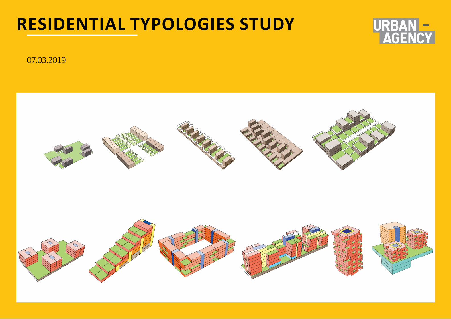
Appendix BResidential Typologies Study
www.fingal.ie
07.03.2019
RESIDENTIAL TYPOLOGIES STUDY
22m5m
25m6m
10m6m

NOTE:This document is for discussion purpose only. All figures shown are an approximate estimation and are subject to further design development, accurate site survey and services (drainages, ESB, gas, etc.) and potential existing site restrictions (flooding, trees preservation, traffic, fire etc.). Please note also that any proposed concept layout in this document is subject to full planning permission being granted.
All drawings are copyright of Urban Agency E&OESWORDS MASTERPLAN URBAN-AGENCY 3
TYPOLOGY 1
Three-storey townhouse
GROUNDFLOOR FIRSTFLOOR
SECONDFLOOR
NO.OFUNITS-1UNITTYPE-Threebedtownhouse.HEIGHT-Threestoreys.PARKINGSPACES-Twostackedinundercroft.OUTDOORSPACE-Privatereargarden.
SECTION
AXO

SECONDFLOOR
GROUNDFLOOR FIRSTFLOOR
NOTE:This document is for discussion purpose only. All figures shown are an approximate estimation and are subject to further design development, accurate site survey and services (drainages, ESB, gas, etc.) and potential existing site restrictions (flooding, trees preservation, traffic, fire etc.). Please note also that any proposed concept layout in this document is subject to full planning permission being granted.
All drawings are copyright of Urban Agency E&OESWORDS MASTERPLAN URBAN-AGENCY 4
Houseovercarpark(parkingservesapartmentsandhouses)
TYPOLOGY 2
NO.OFUNITS-1UNITTYPE-3bedhouseoverparking.HEIGHT-Twostorey,threewithcarpark.PARKINGSPACES-Groundlevelcarpark.2perunit.OUTDOORSPACE-Privatebalconyandfrontgarden.
SECTION
AXO

NOTE:This document is for discussion purpose only. All figures shown are an approximate estimation and are subject to further design development, accurate site survey and services (drainages, ESB, gas, etc.) and potential existing site restrictions (flooding, trees preservation, traffic, fire etc.). Please note also that any proposed concept layout in this document is subject to full planning permission being granted.
All drawings are copyright of Urban Agency E&OESWORDS MASTERPLAN URBAN-AGENCY 5
TYPOLOGY 3
Duplexoverduplex
GROUNDFLOOR FIRSTFLOOR
SECONDFLOOR THIRDFLOOR
SECTION
AXO
NO.OFUNITS-4UNITTYPE-2bedduplexabove1bedduplex.HEIGHT-Twostoreyperunit,fourstoreytotal.PARKINGSPACES-Oneundercroftandoneonstreet.OUTDOORSPACE-Privatereargardenorprivatebalcony.

ApartmentType2b ApartmentType3
NOTE:This document is for discussion purpose only. All figures shown are an approximate estimation and are subject to further design development, accurate site survey and services (drainages, ESB, gas, etc.) and potential existing site restrictions (flooding, trees preservation, traffic, fire etc.). Please note also that any proposed concept layout in this document is subject to full planning permission being granted.
All drawings are copyright of Urban Agency E&OESWORDS MASTERPLAN URBAN-AGENCY 6
TYPOLOGY 4
ApartmentType1 ApartmentType2a
ApartmentsSection
NO.OFUNITS-2-3UNITTYPE-1,2,3,4bedmixHEIGHT-3-9storeysPARKINGSPACES-Undergroundresidentandgroundlevelvisitorparking.OUTDOORSPACE-Privatebalconies.
ApartmentType1b

NOTE:This document is for discussion purpose only. All figures shown are an approximate estimation and are subject to further design development, accurate site survey and services (drainages, ESB, gas, etc.) and potential existing site restrictions (flooding, trees preservation, traffic, fire etc.). Please note also that any proposed concept layout in this document is subject to full planning permission being granted.
All drawings are copyright of Urban Agency E&OESWORDS MASTERPLAN URBAN-AGENCY 7
TYPOLOGY 4
ApartmentType4 ApartmentType5aNO.OFUNITS-5/6UNITTYPE-1,2,3,4bedmixHEIGHT-3-9storeysPARKINGSPACES-Undergroundresidentandgroundlevelvisitorparking.OUTDOORSPACE-Privatebalconies.
ApartmentType5b

NOTE:This document is for discussion purpose only. All figures shown are an approximate estimation and are subject to further design development, accurate site survey and services (drainages, ESB, gas, etc.) and potential existing site restrictions (flooding, trees preservation, traffic, fire etc.). Please note also that any proposed concept layout in this document is subject to full planning permission being granted.
All drawings are copyright of Urban Agency E&OESWORDS MASTERPLAN URBAN-AGENCY 8
OFFICE TYPOLOGIES
OfficeType1 OfficeType2 OfficeType3

dub l in@urban-agency. comwww. u r b a n - a g e n c y . c o m
DUBLIN1 Whitaker CourtSir John Rogerson’s QuayDublin 2+353 1 672 5907
COPENHAGENKirsten Walthers Vej 9DK-2500 ValbyCopenhagen+45 3324 5420
LYON14 Avenue MarcSangnier69100 Lyon+33 9 70 44 09 33
NOTE:Thisdocumentisfordiscussionpurposeonly.Allfiguresshownareanapproximateestimationandaresubjecttofurtherdesigndevelopment,accuratesitesurveyandservices(drainages,ESB,gas,etc.)andpotentialexistingsiterestrictions(flooding,treespreservation,traffic,fireetc.).Pleasenotealsothatanyproposedconceptlayoutinthisdocumentissubjecttofullplanningpermissionbeinggranted.
AlldrawingsarecopyrightofUrbanAgency E&OE