table f.1. capital improvement program - pioneer … control carp population: other lakes 10,000 500...
TRANSCRIPT

Table F.1. Capital Improvement ProgramNote: See project descriptions following the tables. PSC = Pioneer-Sarah WMC
CAPITAL PROJECTS2014- ME-1 Lake Ardmore infiltration basin 30,000 3,000 Complete PSC, Medina 3316.352015 IN-1 Lake Sarah curlyleaf pondweed treatment 40,000 4,000 Complete PSC, Ind, Grfld, lake assn 2104.73 1011.26
IN-2 Hydrologic restorations: HR 67, 68, 29, and 33 200,000 20,000 PSC, IndependenceME-2 Lake Independence curlyleaf pondweed treatment 122,000 12,200 PSC, Med, Ind, lake assn
Subtotal $392,000 $39,200
2016 GR-3 Dance Hall Creek BMPs 200,000 10,000 PSC, Greenfield, grants 302.46GR-4 Feedlot improvements: Dance Hall Creek 35,000 1,750 PSC, Greenfield, grantsGR-9 Buffer strips: Dance Hall Creek 35,000 1,750 PSC, Greenfield, grants
GR-11 Control carp population: other lakes 10,000 500 PSC, Greenfield, DNR, grantsIN-3 Lake Sarah curlyleaf pondweed treatment 32,000 3,200 Complete PSC, Ind, Grfld, lake assn 8986.3IN-4 Gully restorations: GS50 (design) 120,000 12,000 In Process PSC, Independence, grants 5204.65ME-4 Lake Ardmore neighborhood projects 80,000 8,000 Redundant PSC, Medina, grants
Subtotal $512,000 $37,200
2017 IN-5 Lake Sarah curlyleaf pondweed treatment 26,000 2,600 PSC, Indep, Grfld, lake assn 2,600
IN-7 Raingardens in targeted areas 75,000 7,500 PSC, Indep, property owners 7,500
IN-9 Shoreline restoration – Sarah and Independence 125,000 12,500PSC, Ind, Grfd, Medina, property owners, grants 12,500
GR-4 Feedlot improvements: Dance Hall Creek 35,000 1,750 PSC, Greenfield, grantsGR-9 Buffer strips: Dance Hall Creek 35,000 1,750 PSC, Greenfield, grants
2017 IN-3 Wetland Restoration 1 Kazin Property 92,205 23,051 High $549/lbPSC, Indep, County Grant,
NRCS, EQUIP 23,051Subtotal $388,205 $49,151
2018 GR-3 Hafften, Schendel, Schwauppauff BMPs 100,000 10,000 PSC, Greenfield, grantsIN-6 Lake Sarah curlyleaf pondweed treatment 20,000 2,000 PSC, Ind, Grfld, lake assn
2017 ME-1 Fern St Gully Stabilization 18,850 4,713 High $277/lb PSC - $4,713, City, grants 48,2762017 ME-2 Fern St Iron Enhanced Sand Filter 87,500 21,875 $1411/lb PSC - $21,875, City, grants2017 ME-3 Aspen Ave Pond Enlargement PD3 51,550 12,888 $2343/lb PSC - $12,888, City, grants2017 ME-4 Medina Boat Launch Shoreline Restora SR1 22,000 5,500 $550/lb PSC - $5,500, City, grants2017 ME-5 Stream Stabiliza-creek b'tween Lakes Ardmore & Inde 13,200 3,300 $3300/lb PSC - $3,300, City, grants
MP-6 South Ravine cleanup 260,000 26,000 PSC, Maple Plain, grants 26,000
2017 IN-4 Wetland Restoration 18 559,205 139,801 Medium $707/lbPSC, Independence, County
Grant, NRCS, EQUIP 139,8012017 ME_IN-
1 Baker Park Reserve Campground Ravine Stabiliza 485,000 10,500 High $181/yrPSC, cities, BWSR CWF Grant,
county grant 10,500Subtotal $1,617,305 $236,577
2019- ME-5 Sediment sampling in Lake Independence 18,500 1,850 Complete PSC, Medina, Ind, 3 Rivers
2020 IN-8 Sediment sampling in Lake Sarah 12,000 1,200 PSC, Independence, Greenfield 1,200
GR-11 Control carp population: Lake Sarah / other lakes 10,000 500 PSC, Greenfield, DNR, grants 500
IN-9 Shoreline restoration – Sarah and Independence 125,000 12,500PSC, Ind, Med, Grfld, property
owners, grants 12,500
PriorityCost per
lb. 20202018 2019Year
Moved to 2020. Front-end assessments required.
Redundant with new, specific CIPs resulting from SWA. 2017-2020 ME projects
Completed in _________ by TRPD. No funds req'd from Comm.?
Actual2014
Actual2015
Actual2016 2017Project Project Name Total Cost
Commission Share
PotentialFunding Source(s)
Projects infeasible or lacking owner participation. Will be addressed at developmentTreatment not in TMDL. May resubmit project in future
No willing landowner opportuntitesNo willing landowner opportuntites

Table F.1. Capital Improvement ProgramNote: See project descriptions following the tables. PSC = Pioneer-Sarah WMC
PriorityCost per
lb. 20202018 2019YearActual2014
Actual2015
Actual2016 2017Project Project Name Total Cost
Commission Share
PotentialFunding Source(s)
GR-4 Feedlot improvements 35,000 1,750 PSC, Greenfield, grantsIN-2 Hydrologic restorations GS50 (install) 200,000 20,000 PSC, Independence, grants 20,000ME-6 Tomahawk Trail wetland project 230,000 23,000 PSC, Medina, grants 0 23,000
2017 IN-1 JB Gully Stabilization 75,000 18,750 High $300/lbPSC, Ind, County, MPCA, Lake
Assn 18,750
2017 IN-2 Hydrologic restoration 95 Koch property 61,205 15,300 High$317-
$481/lbPSC, Independence, County
Grant, NRCS, EQUIP 15,300
2017 IN-5 Wetland Restoration 91 529,205 79,380 Low $1447/lbPSC, Independence, County
Grant, NRCS, EQUIP 79,380
2017 IN-6 Wetland Restoration 105 543,205 81,481 Medium $845/lbPSC, Independence, County
Grant, NRCS, EQUIP 81,481
2017 IN-7 Seasonal Pond 77 10,420 2,605 High $366/lbPSC, Independence, County
Grant 2,605
2017 MI-1 South Whaletail Lake Alum Treatment 200,000 5,000 High $55/lbPSC, city, BWSR CWF Grant,
county grant 5,000Subtotal $1,849,535 $258,316
SPECIAL STUDIES2015 MP-4 Ravine study 3,000 300 In Process PSC, Maple Plain 3002015 ME-3 Lake Independence Subwatershed Assessment 15,000 1,500 Complete PSC, Medina Completed in May 2014 by Anoka SWCD, no funds requested from Comm.?2018 GR-1 Subw Assess-Hafften, Schendel, Schwauppauff 20,000 1,000 PSC, Greenfield 1,000
Subtotal $38,000 $2,800
2014 Lake Indepenence Outlet Construction 426.63 Lake Independence Bullrush Restoration 1307.8
2015 Lake Independence Weir Construction at Outlet $318 spent out of Operating Budget2016 Lake Ardmore Subwatershed Assessment 218.25
SUBTOTAL $4,797,045 $623,244 4,142$ 4,328$ 14,409$ 45,951$ 225,577$ 231,716$ 28,000$
Capital Projects Account Est January 1 Balance 10109.6 $25,968 $41,640 $55,231 $37,280 ($160,297) ($364,013)Annual Capital Projects Fund Contribution 20,000 20,000 28,000 28,000 28,000 28,000 28,000Estimated Expenditures 4,142 4,328 14,409 45,951 225,577 231,716 28,000Capital Projects Account Estimated December 31 Balance $25,968 $41,640 $55,231 $37,280 ($160,297) ($364,013) ($364,013)
No Year AssignedGR-3,4,9 Ongoing Dance Hall Creek BMPs ??? PSC, City, Grants 15,000 15,000 15,000 15,000
CIP-7 Lindgren Lane Pond 100,000 10,000CIP-8 Koch’s/Mill’s Creek Inlet Ponds (now HR 97 and 29) 200,000 20,000
CIP-11 Manure Management Cost-Share Projects 250,000 25,000LO-1 Chippewa Road Drainage 21,000 2,100 Complete Project completed by city in 2016 - $21,710, No request for funds from CommissionLO-2 Creekview Road Drainage 21,000 2,100LO-3 Retention Pond mapping and cleanup 10,000 1,000LO-4 Ditch Cleaning at Ballpark 10,000 1,000LO-5 Sediment Pond Cleanout 25,000 2,500LO-6 Sediment Pond Cleanout 80,000 8,000MP-1 Drainageway Cleaning –E of Budd 55,000 5,500MP-2 Rock checks, Main St Ravine 23,700 2,370MP-3 Washout, Main St Ravine 8,000 800MP-5 North Ravine Cleanup 286,000 28,600
OTHER PROJECTS COMPLETED

Table F.1. Capital Improvement ProgramNote: See project descriptions following the tables. PSC = Pioneer-Sarah WMC
PriorityCost per
lb. 20202018 2019YearActual2014
Actual2015
Actual2016 2017Project Project Name Total Cost
Commission Share
PotentialFunding Source(s)
Subtotal $1,089,700 $108,970
Lake Independence Weir Construction at Outlet 238.37
$5,886,745 $732,214Other Related Local Projects, No Commission Contribution
GR-2 Whisper Creek WWTP $500,000 $ -
TOTAL COST
Other Projects Funded (non CIP funds)

2017 IN-1 EXHIBIT A
Pioneer-Sarah Creek Watershed Management Commission Capital Improvement Project Submittal
(This submittal will be rated on its completeness and adherence to the goals of the Commission. A second page may be used to provide complete responses.)
City Independence Contact Name Joe Baker Telephone 612-868-8702 Email [email protected]
Address 4648 Woodland Circle, 4650 Woodland Circle and 5590 Lake Sarah Heights Drive, Independence.
Project Name JB Gully Stabilization 1. Is project in Member’s CIP? ( ) yes ( X ) no Proposed CIP Year = 2019-2020 2. Has a feasibility study or an engineering report (circle one) been done for this project? ( ) yes (X ) no Amount Total Estimated Project Cost $75,000 Estimated Commission Share (up to 25%, not to exceed $250,000) $18,750 Other Funding Sources (name them) City/Hennepin County/MPCA 319/Lake Sarah Association. $56,250 $ 3. What is the scope of the project?
Grade, install rock cross vanes, rip rap, bioengineering and revegetation on 700 feet of actively eroding gully areas at 4648 Woodland Circle, 4650 Woodland Circle and 5590 Lake Sarah Heights Drive, Independence. This gully drains into Lake Sarah
4. What is the purpose of the project? What water resource(s) will be impacted by the project? Reduce nutrient and TSS loads to Lake Sarah by approximately 8.4 ton/year and 12.5 lbs/year respectively.
5. What is the anticipated improvement that would result from the project? (Include size of area treated and projected nutrient reduction.) Assume moderate to slight recession rates (ft/yr) of 0.10. Gully length = 700’ Area = 700x5= 3,500 sq. ft. Volume=3500x0.1= 350 cubic feet/year. 350 cu.ft./yr= 33,250 lbs/soil loss per year. 33,350/2000 = 16.6 ton/year. TP per ton = 1.5 lbs. 16.6 x 1.5 = 25 lbs/year
6. How does the project contribute to achieving the goals and programs of the Commission? Reduces phosphorus loads into Lake Sarah by approximately 12.5 lbs/year (assumed delivery rate of 0.5)
0/10 7. Does the project result from a regulatory mandate? ( ) yes ( X ) no How?
0/10/20 8. Does the project address one or more TMDL requirements? ( X ) yes ( ) no Which? Nutrient load reduction.
0/10/20 9. Does the project have an educational component? ( ) yes ( X ) no Describe.
0/10 10. Do all the LGUs responsible for sharing in the cost of the project agree to go forward with this project?
( ) yes ( ) no Identify the LGUs. 10/20 11. Is the project in all the LGUs’ CIPs? ( ) yes ( ) no
1-34 (For TAC use)
12. Does project improve water quality? (0-10)
13. Prevent or correct erosion? (0-10)
14. Prevent flooding? (0-5)
15. Promote groundwater recharge? (0-3)
16. Protect and enhance fish and wildlife habitat? (0-3) 17. Improve or create water recreation facilities? (0-3)
TOTAL (poss 114)
Z:\Pioneer-SarahCreek\CIPs\Exhibit A.doc

2017 IN-1

2017 IN-2
EXHIBIT A
Pioneer-Sarah Creek Watershed Management Commission Capital Improvement Project Submittal
(This submittal will be rated on its completeness and adherence to the goals of the Commission. A second page may be used to provide complete responses.)
City Independence Contact Name Joe Baker Telephone 612-868-8702 Email [email protected] Address
Project Name Hydrologic Restoration 95. Koch Property structure 1. Is project in Member’s CIP? ( ) yes ( ) no Proposed CIP Year = 2. Has a feasibility study or an engineering report (circle one) been done for this project? ( X) yes ( ) no Amount Total Estimated Project Cost (construction costs/easement costs) $23,750/$27,500 Estimated Commission Share (up to 25%, not to exceed $250,000) $15,300 Other Funding Sources (name them) NRCS EQUIP?
Up to 75% from---SWCD State Cost Share? Hennepin Co Good Steward Grant? $45,900 $61,205 3. What is the scope of the project? The site is partially drained.
This project would install berm and outlet control structure to increase water levels to pre-historic elevations.
4. What is the purpose of the project? What water resource(s) will be impacted by the project?
Reduce TP/TSS to Lake Independence by 19,000 and 9.64 pounds/year respectively.
5. What is the anticipated improvement that would result from the project? (Include size of area treated and projected nutrient reduction.)
Area treated will be ~3 acres.
6. How does the project contribute to achieving the goals and programs of the Commission?
Reduces external TP/TSS loads to Lake Independence per TMDL 0/10 7. Does the project result from a regulatory mandate? ( ) yes ( X ) no How?
0/10/20 8. Does the project address one or more TMDL requirements? ( X ) yes ( ) no Which? External TP/TSS loads to Lake Independence
0/10/20 9. Does the project have an educational component? ( ) yes ( X ) no Describe. 0/10 10. Do all the LGUs responsible for sharing in the cost of the project agree to go forward with this project?
(X ) yes ( ) no Identify the LGUs. City of Independence is the WCA LGU on this site. 10/20 11. Is the project in all the LGUs’ CIPs? ( X ) yes ( ) no This project was identified in the City’s Lake
Sarah and Lake Independence Stormwater Retrofit Anaylsis. 1-34 (For TAC use)
12. Does project improve water quality? (0-10)
13. Prevent or correct erosion? (0-10)
14. Prevent flooding? (0-5)
15. Promote groundwater recharge? (0-3)
16. Protect and enhance fish and wildlife habitat? (0-3) 17. Improve or create water recreation facilities? (0-3)
TOTAL (poss 114)
Z:\Pioneer-SarahCreek\CIPs\Exhibit A.doc

2017 IN-2

2017 IN-3 EXHIBIT A
Pioneer-Sarah Creek Watershed Management Commission Capital Improvement Project Submittal
(This submittal will be rated on its completeness and adherence to the goals of the Commission. A second page may be used to provide complete responses.)
City Independence Contact Name Joe Baker Telephone 612-868-8702 Email [email protected] Address
Project Name Wetland Restoration 1. Kazin Property structure 1. Is project in Member’s CIP? ( ) yes ( ) no Proposed CIP Year = 2017 2. Has a feasibility study or an engineering report (circle one) been done for this project? ( X) yes ( ) no Amount Total Estimated Project Cost (construction costs/easement costs) $92,205 Estimated Commission Share (up to 25%, not to exceed $250,000) $23,051 Other Funding Sources (name them) NRCS EQUIP?
Up to 75% from---SWCD State Cost Share? Hennepin Co Good Steward Grant? $69,153 $92,205 3. What is the scope of the project? The site is partially drained.
This project would install berm and outlet control structure to increase water levels to pre-historic elevations.
4. What is the purpose of the project? What water resource(s) will be impacted by the project?
Reduce TP/TSS to Lake Independence by 6,926 and 8.39 pounds/year respectively… or $549 per lb of P per year.
5. What is the anticipated improvement that would result from the project? (Include size of area treated and projected nutrient reduction.)
Area treated will be ~3 acres.
6. How does the project contribute to achieving the goals and programs of the Commission?
Reduces external TP/TSS loads to Lake Independence per TMDL
0/10 7. Does the project result from a regulatory mandate? ( ) yes ( X ) no How?
0/10/20 8. Does the project address one or more TMDL requirements? ( X ) yes ( ) no Which? External TP/TSS loads to Lake Independence
0/10/20 9. Does the project have an educational component? ( ) yes ( X ) no Describe.
0/10 10. Do all the LGUs responsible for sharing in the cost of the project agree to go forward with this project?
(X ) yes ( ) no Identify the LGUs. City of Independence is the WCA LGU on this site. 10/20 11. Is the project in all the LGUs’ CIPs? ( X ) yes ( ) no This project was identified in the City’s Lake
Sarah and Lake Independence Stormwater Retrofit Anaylsis. 1-34 (For TAC use)
12. Does project improve water quality? (0-10)
13. Prevent or correct erosion? (0-10)
14. Prevent flooding? (0-5)
15. Promote groundwater recharge? (0-3)
16. Protect and enhance fish and wildlife habitat? (0-3) 17. Improve or create water recreation facilities? (0-3)
TOTAL (poss 114)
Z:\Pioneer-SarahCreek\CIPs\Exhibit A.doc

2017 IN-3

2017 IN-4 EXHIBIT A
Pioneer-Sarah Creek Watershed Management Commission Capital Improvement Project Submittal
(This submittal will be rated on its completeness and adherence to the goals of the Commission. A second page may be used to provide complete responses.)
City Independence Contact Name Joe Baker Telephone 612-868-8702 Email [email protected] Address
Project Name Wetland Restoration 18. Multiple properties 1. Is project in Member’s CIP? ( ) yes ( ) no Proposed CIP Year = 2018 2. Has a feasibility study or an engineering report (circle one) been done for this project? ( X) yes ( ) no Amount Total Estimated Project Cost (construction costs/easement costs) $559,205 Estimated Commission Share (up to 25%, not to exceed $250,000) $139,801 Other Funding Sources (name them) NRCS EQUIP?
Up to 75% from---SWCD State Cost Share? Hennepin Co Good Steward Grant? $419,404 $559,205 3. What is the scope of the project? The site is partially drained.
This project would install a channel weir control structure to increase water levels to pre-historic elevations.
4. What is the purpose of the project? What water resource(s) will be impacted by the project?
Reduce TP/TSS to Lake Independence by 21,162 and 39.5 pounds/year respectively… or $707 per lb of P per year.
5. What is the anticipated improvement that would result from the project? (Include size of area treated and projected nutrient reduction.)
The pooling area will be 44.3 acres.
6. How does the project contribute to achieving the goals and programs of the Commission?
Reduces external TP/TSS loads to Lake Independence per TMDL
0/10 7. Does the project result from a regulatory mandate? ( ) yes ( X ) no How?
0/10/20 8. Does the project address one or more TMDL requirements? ( X ) yes ( ) no Which? External TP/TSS loads to Lake Independence
0/10/20 9. Does the project have an educational component? ( ) yes ( X ) no Describe.
0/10 10. Do all the LGUs responsible for sharing in the cost of the project agree to go forward with this project?
(X ) yes ( ) no Identify the LGUs. City of Independence is the WCA LGU on this site. 10/20 11. Is the project in all the LGUs’ CIPs? ( X ) yes ( ) no This project was identified in the City’s Lake
Sarah and Lake Independence Stormwater Retrofit Anaylsis. 1-34 (For TAC use)
12. Does project improve water quality? (0-10)
13. Prevent or correct erosion? (0-10)
14. Prevent flooding? (0-5)
15. Promote groundwater recharge? (0-3)
16. Protect and enhance fish and wildlife habitat? (0-3) 17. Improve or create water recreation facilities? (0-3)
TOTAL (poss 114)
Z:\Pioneer-SarahCreek\CIPs\Exhibit A.doc

2017 IN-4

2017 IN-5 EXHIBIT A
Pioneer-Sarah Creek Watershed Management Commission Capital Improvement Project Submittal
(This submittal will be rated on its completeness and adherence to the goals of the Commission. A second page may be used to provide complete responses.)
City Independence Contact Name Joe Baker Telephone 612-868-8702 Email [email protected] Address
Project Name Wetland Restoration 91. Multiple properties 1. Is project in Member’s CIP? ( ) yes ( ) no Proposed CIP Year = 2019 2. Has a feasibility study or an engineering report (circle one) been done for this project? ( X) yes ( ) no Amount Total Estimated Project Cost (construction costs/easement costs) $529,205 Estimated Commission Share (up to 25%, not to exceed $250,000) $79,380 (15%) Other Funding Sources (name them) NRCS EQUIP?
Up to 75% from---SWCD State Cost Share? Hennepin Co Good Steward Grant? $396,903 City of Independence share $52,922 3. What is the scope of the project? The site is partially drained.
This project would install a channel weir control structure to increase water levels to pre-historic elevations.
4. What is the purpose of the project? What water resource(s) will be impacted by the project?
Reduce TP/TSS to Lake Independence by 17,068 and 18.3 pounds/year respectively… or $1,447 per lb of P per year.
5. What is the anticipated improvement that would result from the project? (Include size of area treated and projected nutrient reduction.)
The pooling area will be 23.9 acres.
6. How does the project contribute to achieving the goals and programs of the Commission?
Reduces external TP/TSS loads to Lake Independence per TMDL 0/10 7. Does the project result from a regulatory mandate? ( ) yes ( X ) no How?
0/10/20 8. Does the project address one or more TMDL requirements? ( X ) yes ( ) no Which? External TP/TSS loads to Lake Independence
0/10/20 9. Does the project have an educational component? ( ) yes ( X ) no Describe.
0/10 10. Do all the LGUs responsible for sharing in the cost of the project agree to go forward with this project?
(X ) yes ( ) no Identify the LGUs. City of Independence is the WCA LGU on this site. 10/20 11. Is the project in all the LGUs’ CIPs? ( X ) yes ( ) no This project was identified in the City’s Lake
Sarah and Lake Independence Stormwater Retrofit Anaylsis. 1-34 (For TAC use)
12. Does project improve water quality? (0-10)
13. Prevent or correct erosion? (0-10)
14. Prevent flooding? (0-5)
15. Promote groundwater recharge? (0-3)
16. Protect and enhance fish and wildlife habitat? (0-3) 17. Improve or create water recreation facilities? (0-3)
TOTAL (poss 114)
Z:\Pioneer-SarahCreek\CIPs\Exhibit A.doc

2017 IN-5

2017 IN-6 EXHIBIT A
Pioneer-Sarah Creek Watershed Management Commission Capital Improvement Project Submittal
(This submittal will be rated on its completeness and adherence to the goals of the Commission. A second page may be used to provide complete responses.)
City Independence Contact Name Joe Baker Telephone 612-868-8702 Email [email protected] Address
Project Name Wetland Restoration 105. Multiple properties 1. Is project in Member’s CIP? ( ) yes ( ) no Proposed CIP Year = 2019 2. Has a feasibility study or an engineering report (circle one) been done for this project? ( X) yes ( ) no Amount Total Estimated Project Cost (construction costs/easement costs) $543,205 Estimated Commission Share (up to 25%, not to exceed $250,000) $81,481 (15%) Other Funding Sources (name them) NRCS EQUIP?
Up to 75% from---SWCD State Cost Share? Hennepin Co Good Steward Grant? $407,403 City of Independence share $54,321 3. What is the scope of the project? The site is partially drained.
This project would install a box weir control structure to increase water levels to pre-historic elevations.
4. What is the purpose of the project? What water resource(s) will be impacted by the project?
Reduce TP/TSS to Lake Independence by 52,825 and 32.1 pounds/year respectively… or $845 per lb of P per year.
5. What is the anticipated improvement that would result from the project? (Include size of area treated and projected nutrient reduction.)
The pooling area will be 35.9 acres.
6. How does the project contribute to achieving the goals and programs of the Commission?
Reduces external TP/TSS loads to Lake Independence per TMDL
0/10 7. Does the project result from a regulatory mandate? ( ) yes ( X ) no How?
0/10/20 8. Does the project address one or more TMDL requirements? ( X ) yes ( ) no Which? External TP/TSS loads to Lake Independence
0/10/20 9. Does the project have an educational component? ( X ) yes ( ) no Describe.
0/10 10. Do all the LGUs responsible for sharing in the cost of the project agree to go forward with this project?
(X ) yes ( ) no Identify the LGUs. City of Independence is the WCA LGU on this site. 10/20 11. Is the project in all the LGUs’ CIPs? ( X ) yes ( ) no This project was identified in the City’s Lake
Sarah and Lake Independence Stormwater Retrofit Anaylsis. 1-34 (For TAC use)
12. Does project improve water quality? (0-10)
13. Prevent or correct erosion? (0-10)
14. Prevent flooding? (0-5)
15. Promote groundwater recharge? (0-3)
16. Protect and enhance fish and wildlife habitat? (0-3) 17. Improve or create water recreation facilities? (0-3)
TOTAL (poss 114)
Z:\Pioneer-SarahCreek\CIPs\Exhibit A.doc

2017 IN-6

2017 IN-7 EXHIBIT A
Pioneer-Sarah Creek Watershed Management Commission Capital Improvement Project Submittal
(This submittal will be rated on its completeness and adherence to the goals of the Commission. A second page may be used to provide complete responses.)
City Independence Contact Name Joe Baker Telephone 612-868-8702 Email [email protected] Address
Project Name Seasonal Pond 77 1. Is project in Member’s CIP? ( ) yes ( x ) no Proposed CIP Year = 2019 2. Has a feasibility study or an engineering report (circle one) been done for this project? ( x ) yes ( )
no subwatershed assessment Amount Total Estimated Project Cost $10,420 Estimated Commission Share (up to 25%, not to exceed $250,000) $2,650 Other Funding Sources (name them) City, Henn Cty grant $7,815 $ 3. What is the scope of the project? Install control structure to allow land owner full control of water levels.
Allows water to pond from after harvest in the fall to before planting in the spring.
4. What is the purpose of the project? Can result in longer growing season, will reduce nutrient-laden runoff from site. What water resource(s) will be impacted by the project? Lake Independence.
5. What is the anticipated improvement that would result from the project? (Include size of area treated and projected nutrient reduction.) 17.56 acres, $365.61/lb.2.85 lbs/yr TP removal, $0.52/lb2,000 lbs/yr TSS removal, $484.65/ 2.15 ac-ft/year volume removal..
6. How does the project contribute to achieving the goals and programs of the Commission? Ground water recharge, volume control, TP and TSS reductions. Helps reverse the results of the winter freeze/spring thaw scenario. Surface soils can be thawed while frost persists in the subsoil, preventing infiltration and increasing amount of runoff over saturated and highly erodible surface soil. Winter applications of manure from livestock operations greatly increase nutrient concentration in snowmelt and spring rains. Fish spawning is disrupted by highly turbid and nutrient rich spring runoff.
0/10 7. Does the project result from a regulatory mandate? ( ) yes ( x ) no How?
0/10/20 8. Does the project address one or more TMDL requirements? ( x ) yes ( ) no Which? Ground water recharge, volume control, TP and TSS reductions.Nutrient load reduction.
0/10/20 9. Does the project have an educational component? ( x ) yes ( ) no Describe. Can provide agriculturalist with a low-cost, responsible way to reduce nutrient loading to Lake Independence.
0/10 10. Do all the LGUs responsible for sharing in the cost of the project agree to go forward with this project?
( ) yes ( ) no Identify the LGUs. 10/20 11. Is the project in all the LGUs’ CIPs? ( ) yes ( ) no 1-34 (For TAC use)
12. Does project improve water quality? (0-10)
13. Prevent or correct erosion? (0-10)
14. Prevent flooding? (0-5)
15. Promote groundwater recharge? (0-3)
16. Protect and enhance fish and wildlife habitat? (0-3) 17. Improve or create water recreation facilities? (0-3)
TOTAL (poss 114)
Z:\Pioneer-SarahCreek\CIPs\Exhibit A.doc

2017 IN-7

2017 IN-7

2017 IN-7

2017 ME_IN-1
EXHIBIT A
Pioneer-Sarah Creek Watershed Management Commission Capital Improvement Project Submittal
(This submittal will be rated on its completeness and adherence to the goals of the Commission. A second page may be used to provide complete responses.)
City Medina and Independence Contact Name Rich Brasch-Three Rivers Park District Telephone 763-694-2061 Email [email protected] Address 12615 County Road 9, Plymouth, MN 55441
Project Name Baker Park Reserve Campground Ravine Stabilization 1. Is project in Member’s CIP? ( X ) yes ( ) no Proposed CIP Year = 2018 2. Has a feasibility study or an engineering report (circle one) been done for this project? ( X ) yes ( ) no Amount Total Estimated Project Cost $520,000 Estimated Commission Share (up to 25%, not to exceed $250,000) $10,500 Other Funding Sources (name them): BWSR Clean Water Funds Grant $416,000 (max) Hennepin County Opportunity Grant $62,000 Local Cost-share (TRPD, cities of Medina, Independence) $31,500 3. What is the scope of the project? The project would implement the most cost-effective improvements
from the recently completed “Baker Park Reserve Campground Ravine and Subwatershed Assessment”, undertaken as a joint effort by Three Rivers Park District (TRPD), the Pioneer-Sarah Creek Watershed Management Commission (PSCWMC), and the cities of Medina and Independence, and completed in December 2016. Those improvements involve stabilizing the main and two tributary channels of the ravine using a series of rock grade control structures/check dams and lining the channels with a combination of rounded field stone and angular rip-rap up to the expected 10-year flood elevation.
4. What is the purpose of the project? What water resource(s) will be impacted by the project? The purpose of the project is to stabilize about 2,200 feet of eroding ravines, and thereby reduce the amount of sediment and phosphorus exported to Lake Independence. Flow and pollutant loads from the ravine are discharged directly to Lake Independence near the western boundary of TRPD’s Baker Park Reserve
5. What is the anticipated improvement that would result from the project? (Include size of area treated and projected nutrient reduction.) Estimates completed as part of the assessment show that implementation of the proposed improvements would achieve an average annual total phosphorus load reduction to Lake Independence of 112 lbs./yr from the main ravine and an additional 22 lbs./yr. from the 2 tributary ravines (total load reduction of 134 lbs. TP per year). The ravine watershed is about 80 acres, 29 acres of which lie within the City of Independence and 51 acres within the City of Medina, Of the Medina portion of the watershed, approximately 31 acres lie within Baker park Reserve (mostly the campground).
6. How does the project contribute to achieving the goals and programs of the Commission? This project would be a major step forward in implementation of the TMDL for Lake Independence, arguably among the Commission’s highest priority water resources.
0/10 7. Does the project result from a regulatory mandate? (X) yes ( ) no How? The primary regulatory mandate driving the proposed project is the Lake Independence TMDL, approved by both MPCA and USEPA in 2007. The TMDL calls for a watershed phosphorus load reduction of 872 lbs./yr. Less than 150 lbs/yr. of that reduction target has been achieved in the 10 years since the TMDL was completed in 2007. Implementation of this project could almost double that figure.
0/10/20 8. Does the project address one or more TMDL requirements? ( X ) yes ( ) no Which? The proposed project would be a significant step toward compliance with the watershed phosphorus load reduction targets called for in the Lake Independence nutrient TMDL. By itself, the TP load reduction estimated for this project would accomplish about 15% of the total watershed TP load reduction called for in the TMDL.
0/10/20 9. Does the project have an educational component? ( X ) yes ( ) no Describe: At a minimum, the project will include web postings about the project (emphasizing the benefits to Lake Independence and the partnership that made the project happen) on the web sites of the TRPD, the PSCWMC, the two participating cities, and perhaps the LICA web site.

Z:\Pioneer-SarahCreek\CIPs\2017 submittals\2017 ME_IN-1 - Baker Park Reserve campgound ravine stabilization_FINAL.doc
0/10 10. Do all the LGUs responsible for sharing in the cost of the project agree to go forward with this project?
( X ) yes ( ) no Identify the LGUs: The cities of Medina and Independence and Three Rivers Park District.
10/20 11. Is the project in all the LGUs’ CIPs? ( ) yes ( X ) no Not yet; the local match for this project is already in TRPD’s CIP and is expected to be in the CIP for the cities of Medina and Independence for 2018.
1-34 (For TAC use)
12. Does project improve water quality? (0-10)
13. Prevent or correct erosion? (0-10)
14. Prevent flooding? (0-5)
15. Promote groundwater recharge? (0-3)
16. Protect and enhance fish and wildlife habitat? (0-3) 17. Improve or create water recreation facilities? (0-3)
TOTAL (poss 114)
Z:\Pioneer-SarahCreek\CIPs\Exhibit A.doc

2017 ME-1 EXHIBIT A
Pioneer-Sarah Creek Watershed Management Commission Capital Improvement Project Submittal
(This submittal will be rated on its completeness and adherence to the goals of the Commission. A second page may be used to provide complete responses.)
City Medina Contact Name Scott Johnson Telephone (763) 473-4643 Email [email protected] Address 2052 County Road 24, Medina, MN 55340
Project Name GS1 – Fern St. Gully Stabilization 1. Is project in Member’s CIP? ( X ) yes ( ) no Proposed CIP Year = 2017 2. Has a feasibility study or an engineering report (circle one) been done for this project? ( X ) yes ( )
no Amount Total Estimated Project Cost $18,850 Estimated Commission Share (up to 25%, not to exceed $250,000) $4,712.50 Other Funding Sources (grants and City of Medina) $14,137.50 3. What is the scope of the project? Stabilize a gully flowing into a wetland connected to Lake
Independence in the Independence Beach neighborhood in Medina. The gully stabilization will address a 600 sq. ft. erosion area and remove 3.4 lbs. /yr. of phosphorus.
4. What is the purpose of the project? What water resource(s) will be impacted by the project? The purpose of the project is to remove phosphorus from the Ardmore Area Subwatershed to improve water quality in Lake Independence.
5. What is the anticipated improvement that would result from the project? (Include size of area treated and projected nutrient reduction.) The gully stabilization will address a 600 sq. ft. erosion area and remove 3.4 lbs. /yr. of phosphorus.
6. How does the project contribute to achieving the goals and programs of the Commission? The project will address the TMDL goal for the subwatershed by removing 3.4 lbs. /yr. of phosphorus.
0/10 7. Does the project result from a regulatory mandate? ( X ) yes ( ) no How? The project removes 3.4 lbs./yr. of phosphorus from the TMDL
0/10/20 8. Does the project address one or more TMDL requirements? ( X ) yes ( ) no Which? Phosphorus reduction
0/10/20 9. Does the project have an educational component? ( ) yes ( X ) no Describe.
0/10 10. Do all the LGUs responsible for sharing in the cost of the project agree to go forward with this project?
( X ) yes ( ) no Identify the LGUs. 10/20 11. Is the project in all the LGUs’ CIPs? ( X ) yes ( ) no
1-34 (For TAC use)
12. Does project improve water quality? (0-10)
13. Prevent or correct erosion? (0-10)
14. Prevent flooding? (0-5)
15. Promote groundwater recharge? (0-3)
16. Protect and enhance fish and wildlife habitat? (0-3) 17. Improve or create water recreation facilities? (0-3)
TOTAL (poss 114)
Z:\Pioneer-SarahCreek\CIPs\Exhibit A.doc

Ardmore Area Subwatershed Stormwater Retrofit Analysis 19
Gully Stabilization
Gullies are created by concentrated stormwater cutting into the landscape and eroding away the soil.
This occurs when the erosive force of the water flow is greater than the cohesive force of the soil.
Over time the gulley cuts deeper into the soil, creating unstable side slopes. The near vertical side
slopes of the gully then slough in and are transported downstream into the receiving water. Since
particulate phosphorous is attached to the sediment, this directly contributes to the phosphorous
loading into the receiving water. If not repaired, gullies continue to cut and become larger and
contribute to the phosphorous load.
Gullies can be stabilized by using rip rap, boulders, natural vegetation, and manufactured synthetic
products. Stabilization of a gully is a similar process to stabilizing a stream. Riprap can often be
positioned at strategic locations to dissipate the flow and reduce scouring. Vegetation and synthetic
products can also be used to create greater cohesion and resistance to scouring, as well as slowing
down the velocity of water flow.
GS1
The gully north of Fern Street receives concentrated flow via a storm sewer pipe. Field
measurements showed that the gully is approximately 120 feet long. The largest width
measurement was recorded as five-feet, and the largest depth measurement was recorded as four-
feet. In total, it is estimated that 1,390 cubic feet or 50 tons of sediment has been eroded to date.
The BWSR Pollution Reduction Estimator worksheet was utilized to estimate the phosphorous load
that the gully is producing. Stabilizing the gully could reduce the TP load by 100%.
Figure 10U: Stabilization using manufactured synthetic
products; Source: Contech Engineered Solutions
2017 ME-1

Ardmore Area Subwatershed Stormwater Retrofit Analysis 20
Table 7U. Site Summary – GS1
Model Used BWSR worksheet
Erosion Length 120 ft
Erosion Area 600 sq ft
Estimated TP Removal 3.4 lbs/yr
Installation Cost $12,000
Design/Admin $4,000
Maintenance Cost $150
Total 20 Year Cost $18,850
$/lb-TP remov-al /yr $277
Figure 11U: Left— Erosion to the
eastern side of the gully. Right - West side of the gully, eventually
flowing into wetland connected to
Lake Independence.
Figure 12U: Drainage area and location map
2017 ME-1

2017 ME-2 EXHIBIT A
Pioneer-Sarah Creek Watershed Management Commission Capital Improvement Project Submittal
(This submittal will be rated on its completeness and adherence to the goals of the Commission. A second page may be used to provide complete responses.)
City Medina Contact Name Scott Johnson Telephone (763) 473-4643 Email [email protected] Address 2052 County Road 24, Medina, MN 55340
Project Name ISF1 – Fern St. Iron Enhanced Sand Filter 1. Is project in Member’s CIP? ( X ) yes ( ) no Proposed CIP Year = 2017 2. Has a feasibility study or an engineering report (circle one) been done for this project? ( X ) yes ( )
no Amount Total Estimated Project Cost $87,500 Estimated Commission Share (up to 25%, not to exceed $250,000) $21,875 Other Funding Sources (grants and City of Medina) $65,625 3. What is the scope of the project? Install an Iron Enhanced Sand Filter near Fern Street in the
Independence Beach neighborhood in Medina. The filter will treat a 4.1 acre drainage area and remove 3.1 lbs. /yr. of phosphorus.
4. What is the purpose of the project? What water resource(s) will be impacted by the project? The purpose of the project is to remove phosphorus from the Ardmore Area Subwatershed to improve water quality in Lake Independence.
5. What is the anticipated improvement that would result from the project? (Include size of area treated and projected nutrient reduction.) The filter will treat a 4.1 acre drainage area and remove 3.1 lbs. /yr. of phosphorus.
6. How does the project contribute to achieving the goals and programs of the Commission? The project will address the TMDL goal for the subwatershed by removing 3.1 lbs. /yr. of phosphorus.
0/10 7. Does the project result from a regulatory mandate? ( X ) yes ( ) no How? The project removes 3.1 lbs./yr. of phosphorus from the TMDL
0/10/20 8. Does the project address one or more TMDL requirements? ( X ) yes ( ) no Which? Phosphorus reduction
0/10/20 9. Does the project have an educational component? ( ) yes ( X ) no Describe.
0/10 10. Do all the LGUs responsible for sharing in the cost of the project agree to go forward with this project?
( X ) yes ( ) no Identify the LGUs. 10/20 11. Is the project in all the LGUs’ CIPs? ( X ) yes ( ) no
1-34 (For TAC use)
12. Does project improve water quality? (0-10)
13. Prevent or correct erosion? (0-10)
14. Prevent flooding? (0-5)
15. Promote groundwater recharge? (0-3)
16. Protect and enhance fish and wildlife habitat? (0-3) 17. Improve or create water recreation facilities? (0-3)
TOTAL (poss 114)
Z:\Pioneer-SarahCreek\CIPs\Exhibit A.doc

Ardmore Area Subwatershed Stormwater Retrofit Analysis 31
Iron Enhanced Sand Filters (MN Filter)
Similar to enhanced filtering devices, iron enhanced sand filters are efficient in reducing the dissolved
portion of the phosphorous. Iron enhanced filters utilize iron filings within the filter media. As the
stormwater passes through the media, the dissolved phosphorous attaches to the iron filings within
the media, effectively treating the stormwater. A pre-treatment settling basin is utilized upstream of
the iron enhanced filter to settle out the sediment. Any sediment that passes through the pre-
treatment will still have an opportunity to settle out in the iron enhanced filter; however, over time,
sediment may plug the iron enhanced filter and reduce overall effectiveness.
In order for iron enhanced sand filters to be effective, they must be designed to drain after a storm
event in order to prevent hypoxic conditions.
There is one iron enhanced sand filter (ISF1) proposed in this watershed, which is in the same
location as PD2. Only one BMP should be considered at this site; therefore, if an iron enhanced sand
filter is utilized, pond PD2 would not be constructed.
Figure 31U: Schematic of iron enhanced sand filter
Figure 32U: Iron enhanced sand filter; Source: BWSR
2017 ME-2

Ardmore Area Subwatershed Stormwater Retrofit Analysis 32
Table 15U. Site Summary –ISF1
Model Used N/A
Drainage Area 4.1 ac
Proposed Pond Area 5,400 sq ft
Estimated TP removal 3.1 lbs/yr
Installation Cost $58,000
Design/Admin $15,000
Maintenance Cost / yr $500
Total 30 Year Cost $87,500
$/lb-TP removal /yr $941
Figure 33U: Location of the proposed ISF1
Figure 34U: Drainage area and location map
ISF1
2017 ME-2

2017 ME-3 EXHIBIT A
Pioneer-Sarah Creek Watershed Management Commission Capital Improvement Project Submittal
(This submittal will be rated on its completeness and adherence to the goals of the Commission. A second page may be used to provide complete responses.)
City Medina Contact Name Scott Johnson Telephone (763) 473-4643 Email [email protected] Address 2052 County Road 24, Medina, MN 55340
Project Name PD3 – Aspen Avenue Pond Enlargement/Excavation 1. Is project in Member’s CIP? ( X ) yes ( ) no Proposed CIP Year = 2017 2. Has a feasibility study or an engineering report (circle one) been done for this project? ( X ) yes ( )
no Amount Total Estimated Project Cost $51,550 Estimated Commission Share (up to 25%, not to exceed $250,000) $12,887.50 Other Funding Sources (grants and City of Medina) $38,662.50 3. What is the scope of the project? Enlarge and excavate an existing storm water pond on Aspen Avenue
in the Independence Beach neighborhood in Medina. The pond will treat an 8 acre drainage area and remove 1.1 lbs. /yr. of phosphorus.
4. What is the purpose of the project? What water resource(s) will be impacted by the project? The purpose of the project is to remove phosphorus from the Ardmore Area Subwatershed to improve water quality in Lake Ardmore.
5. What is the anticipated improvement that would result from the project? (Include size of area treated and projected nutrient reduction.) The pond will treat an 8 acre drainage area and remove 1.1 lbs. /yr. of phosphorus.
6. How does the project contribute to achieving the goals and programs of the Commission? The project will address the TMDL goal for the subwatershed by removing 1.1 lbs. /yr. of phosphorus.
0/10 7. Does the project result from a regulatory mandate? ( X ) yes ( ) no How? The project removes 1.1 lbs./yr. of phosphorus from the TMDL
0/10/20 8. Does the project address one or more TMDL requirements? ( X ) yes ( ) no Which? Phosphorus reduction
0/10/20 9. Does the project have an educational component? ( ) yes ( X ) no Describe.
0/10 10. Do all the LGUs responsible for sharing in the cost of the project agree to go forward with this project?
( X ) yes ( ) no Identify the LGUs. 10/20 11. Is the project in all the LGUs’ CIPs? ( X ) yes ( ) no
1-34 (For TAC use)
12. Does project improve water quality? (0-10)
13. Prevent or correct erosion? (0-10)
14. Prevent flooding? (0-5)
15. Promote groundwater recharge? (0-3)
16. Protect and enhance fish and wildlife habitat? (0-3) 17. Improve or create water recreation facilities? (0-3)
TOTAL (poss 114)
Z:\Pioneer-SarahCreek\CIPs\Exhibit A.doc
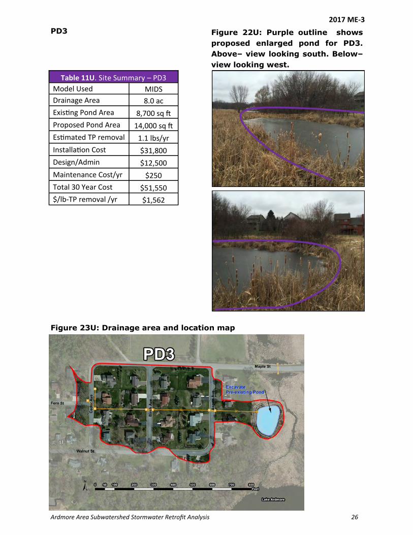
Ardmore Area Subwatershed Stormwater Retrofit Analysis 26
Table 11U. Site Summary – PD3
Model Used MIDS
Drainage Area 8.0 ac
Existing Pond Area 8,700 sq ft
Proposed Pond Area 14,000 sq ft
Estimated TP removal 1.1 lbs/yr
Installation Cost $31,800
Design/Admin $12,500
Maintenance Cost/yr $250
Total 30 Year Cost $51,550
$/lb-TP removal /yr $1,562
Figure 22U: Purple outline shows
proposed enlarged pond for PD3.
Above– view looking south. Below–
view looking west.
Figure 23U: Drainage area and location map
PD3
2017 ME-3

2017 ME-4 EXHIBIT A
Pioneer-Sarah Creek Watershed Management Commission Capital Improvement Project Submittal
(This submittal will be rated on its completeness and adherence to the goals of the Commission. A second page may be used to provide complete responses.)
City Medina Contact Name Scott Johnson Telephone (763) 473-4643 Email [email protected] Address 2052 County Road 24, Medina, MN 55340
Project Name SR1 – Medina Boat Launch Shoreline Restoration 1. Is project in Member’s CIP? ( X ) yes ( ) no Proposed CIP Year = 2017 2. Has a feasibility study or an engineering report (circle one) been done for this project? ( X ) yes ( )
no Amount Total Estimated Project Cost $22,000 Estimated Commission Share (up to 25%, not to exceed $250,000) $5,500 Other Funding Sources (grants and City of Medina) $16,500 3. What is the scope of the project? 160 ft. shoreline restoration project at the City of Medina Boat Launch
in the Independence Beach neighborhood in Medina. The shoreline restoration will remove 2.0 lbs. /yr. of phosphorus.
4. What is the purpose of the project? What water resource(s) will be impacted by the project? The purpose of the project is to remove phosphorus from the Ardmore Area Subwatershed to improve water quality in Lake Independence.
5. What is the anticipated improvement that would result from the project? (Include size of area treated and projected nutrient reduction.) The shoreline restoration will remove 2.0 lbs. /yr. of phosphorus.
6. How does the project contribute to achieving the goals and programs of the Commission? The project will address the TMDL goal for the subwatershed by removing 2.0 lbs. /yr. of phosphorus.
0/10 7. Does the project result from a regulatory mandate? ( X ) yes ( ) no How? The project removes 2.0 lbs./yr. of phosphorus from the TMDL
0/10/20 8. Does the project address one or more TMDL requirements? ( X ) yes ( ) no Which? Phosphorus reduction
0/10/20 9. Does the project have an educational component? ( ) yes ( X ) no Describe.
0/10 10. Do all the LGUs responsible for sharing in the cost of the project agree to go forward with this project?
( X ) yes ( ) no Identify the LGUs. 10/20 11. Is the project in all the LGUs’ CIPs? ( X ) yes ( ) no
1-34 (For TAC use)
12. Does project improve water quality? (0-10)
13. Prevent or correct erosion? (0-10)
14. Prevent flooding? (0-5)
15. Promote groundwater recharge? (0-3)
16. Protect and enhance fish and wildlife habitat? (0-3) 17. Improve or create water recreation facilities? (0-3)
TOTAL (poss 114)
Z:\Pioneer-SarahCreek\CIPs\Exhibit A.doc

Ardmore Area Subwatershed Stormwater Retrofit Analysis 21
Shoreline Restoration
Shoreline erosion is also a source of phosphorus. All of the sediment created by shoreline erosion is
directly deposited into the lake with no chance for treatment. Visual observations revealed that
shoreline erosion is occurring near Lakeshore Park on either side of the boat ramp. The erosion is
approximately 160 ft. long and is estimated to contribute 2 lbs/yr of phosphorus to Lake
Independence. This phosphorus load could be greatly reduced by stopping the erosion and restoring
the shoreline.
Shoreline restoration is not much different than gully and stream stabilization. Shoreline restoration
may include the use of rip rap boulders near the water surface to armor the shore against the wave
action. Vegetation can be re-established above the hard armor, which will penetrate deep into the
underlying soil to prevent erosion and reduce the velocity of the stormwater that flows down the
bank.
Figure 13U: Photo of shoreline stabilization; Source: MN DNR
2017 ME-4

Ardmore Area Subwatershed Stormwater Retrofit Analysis 22
Figure 14U: Close up of the
shoreline erosion Table 8U. Site Summary - SR1
Model Used BWSR worksheet
Eroding Shoreline 160 ft
Estimated TP Removal 2.0 lbs/yr
Installation Cost $16,000
Design/Admin $1,500
Maintenance Cost / yr $240
Total 20 Year Cost $22,000
$/lb-TP removal /yr $550
Figure 15U: The erosion exists on both sides of the boat launch. It extends
approximately 120 ft. to the right of the launch and 40 ft. to the left.
Figure 16U: Drainage area and location map
SR1
2017 ME-4

2017 ME-5 EXHIBIT A
Pioneer-Sarah Creek Watershed Management Commission Capital Improvement Project Submittal
(This submittal will be rated on its completeness and adherence to the goals of the Commission. A second page may be used to provide complete responses.)
City Medina Contact Name Scott Johnson Telephone (763) 473-4643 Email [email protected] Address 2052 County Road 24, Medina, MN 55340
Project Name SS1 - Stream Stabilization on creek between Lake Ardmore and Lake Independence 1. Is project in Member’s CIP? ( X ) yes ( ) no Proposed CIP Year = 2017 2. Has a feasibility study or an engineering report (circle one) been done for this project? ( X ) yes ( )
no Amount Total Estimated Project Cost $13,200 Estimated Commission Share (up to 25%, not to exceed $250,000) $3,300 Other Funding Sources (grants and City of Medina) $9,900 3. What is the scope of the project? Stabilize the creek between Lake Ardmore and Lake Independence in
the Independence Beach neighborhood in Medina. The stream stabilization will address a 110 sq. ft. erosion area and remove .2 lbs. /yr. of phosphorus.
4. What is the purpose of the project? What water resource(s) will be impacted by the project? The purpose of the project is to remove phosphorus from the Ardmore Area Subwatershed to improve water quality in Lake Independence.
5. What is the anticipated improvement that would result from the project? (Include size of area treated and projected nutrient reduction.) The stream stabilization will address a 110 sq. ft. erosion area and remove .2 lbs. /yr. of phosphorus.
6. How does the project contribute to achieving the goals and programs of the Commission? The project will address the TMDL goal for the subwatershed by removing .2 lbs. /yr. of phosphorus.
0/10 7. Does the project result from a regulatory mandate? ( X ) yes ( ) no How? The project removes .2 lbs./yr. of phosphorus from the TMDL
0/10/20 8. Does the project address one or more TMDL requirements? ( X ) yes ( ) no Which? Phosphorus reduction
0/10/20 9. Does the project have an educational component? ( ) yes ( X ) no Describe.
0/10 10. Do all the LGUs responsible for sharing in the cost of the project agree to go forward with this project?
( X ) yes ( ) no Identify the LGUs. 10/20 11. Is the project in all the LGUs’ CIPs? ( X ) yes ( ) no
1-34 (For TAC use)
12. Does project improve water quality? (0-10)
13. Prevent or correct erosion? (0-10)
14. Prevent flooding? (0-5)
15. Promote groundwater recharge? (0-3)
16. Protect and enhance fish and wildlife habitat? (0-3) 17. Improve or create water recreation facilities? (0-3)
TOTAL (poss 114)
Z:\Pioneer-SarahCreek\CIPs\Exhibit A.doc

2017 ME-5

2017 MI-1
EXHIBIT A
Pioneer-Sarah Creek Watershed Management Commission Capital Improvement Project Submittal (2-23-2017 DRAFT)
(This submittal will be rated on its completeness and adherence to the goals of the Commission. A second page may be used to provide complete responses.)
City Minnestrista Contact Name Rich Brasch-Three Rivers Park District Telephone 763-694-2061 Email [email protected] Address 12615 County Road 9, Plymouth, MN 55441
Project Name South Whaletail Lake Alum Treatment 1. Is project in Member’s CIP? ( ) yes ( X ) no Proposed CIP Year 2020 2. Has a feasibility study or an engineering report (circle one) been done for this project? ( ) yes ( X ) no Amount Total Estimated Project Cost $200,000 Estimated Commission Share (up to 25%, not to exceed $250,000) $5,000 Other Funding Sources (name them): BWSR Clean Water Funds Grant $160,000 (max) Hennepin County Opportunity Grant $20,000 Local Cost-share (TRPD, City of Minnetrista) $15,000 3. What is the scope of the project? This project will involve treatment of South Whaletail Lake with alum
to reduce internal loading of phosphorus that negatively affects the lake’s surface water quality. The application of alum would likely occur in two phases separated by 1-2 years to maximize the effectiveness of the treatment.
4. What is the purpose of the project? What water resource(s) will be impacted by the project? The purpose of the project is to reduce the internal load to the degree necessary to meet the state in-lake water quality standard for at last a 20-year period. South Whaletail Lake will be directly impacted by the treatment, but there will be a small positive effect on North Whaletail Lake as well because it will receive a higher quality discharge from South Whaletail Lake than it does under current conditions.
5. What is the anticipated improvement that would result from the project? (Include size of area treated and projected nutrient reduction.) The nearly completed Pioneer Sarah Creek Watershed Total Maximum Daily Load (TMDL) Study and Watershed Restoration and Protection Plan (WRAPs) report identifies release of phosphorus from enriched bottom sediments as the source of about 80% of the phosphorus load negatively affecting surface water quality in South Whaletail Lake. The goal of treating the lake with alum is to reduce the phosphorus load affecting the lake by at least 180.2 lbs./yr., which will meet the load reduction requirements identified in the TMDL and allow the lake to meet state water quality standards for phosphorus. It is anticipated that about 90 acres of the 156-acre lake will need to be treated with alum to achieve this reduction.
6. How does the project contribute to achieving the goals and programs of the Commission? This project would be a major step forward in implementation of the TMDL for South Whaletail Lake, one of the Commission’s high priority water resources. Preliminary estimates are that the cost-effectiveness of the treatment in reducing phosphorus loading affecting surface water quality in the lake is about $80/lb. TP load reduction over a 20 year period.
0/10 7. Does the project result from a regulatory mandate? (X) yes ( ) no How? The primary regulatory mandate driving the proposed project is the Pioneer Sarah Creek Watershed TMDL and WRAPS project. Because South Whaletail Lake is listed as an impaired water, the TMDL calls for a load reduction of 180.2 lbs./yr of TP to meet the TMDL requirements and improve water quality in the lake enough to consistently meet the state water quality standard applicable to the lake.
0/10/20 8. Does the project address one or more TMDL requirements? ( X ) yes ( ) no Which? The proposed project would decrease the phosphorus load affecting the lake enough to fully meet the reduction called for in the TMDL. It is anticipated that proper execution of the alum treatment would result in water quality that is good enough over the long term to support removal of the lake from the impaired waters list. .
Z:\Pioneer-SarahCreek\CIPs\2017 submittals\2017 MI-1_CIP South Whaletail Lake alum treatment_DRAFT.doc
0/10/20 9. Does the project have an educational component? ( X ) yes ( ) no Describe: At a minimum, the project will include web postings about the project (emphasizing the benefits to South Whaletail Lake and the partnership that made the project happen) on the web sites of the City of Minnetrista, TRPD, and the PSCWMC.
0/10 10. Do all the LGUs responsible for sharing in the cost of the project agree to go forward with this project?
( X ) yes ( ) no Identify the LGUs: The City of Minnetrista and Three Rivers Park District. 10/20 11. Is the project in all the LGUs’ CIPs? ( ) yes ( X ) no Not yet; the local match for this project is
already in TRPD’s CIP and is expected to be in the CIP for the City of Minnetrista by 2020. 1-34 (For TAC use)
12. Does project improve water quality? (0-10)
13. Prevent or correct erosion? (0-10)
14. Prevent flooding? (0-5)
15. Promote groundwater recharge? (0-3)
16. Protect and enhance fish and wildlife habitat? (0-3) 17. Improve or create water recreation facilities? (0-3)
TOTAL (poss 114)
Z:\Pioneer-SarahCreek\CIPs\Exhibit A.doc

2017 ME-5

CIP List - February 2017
Project Project Name Total CostComm Share 2014 2015 2016 Total Project ExpME-1 Lake Ardmore infiltration basin 66,326 3,000 3316.35 3316.35IN-1 Lake Sarah curlyleaf pondweed treatment 67,105 4,000 2104.73 1011.26 8986.30 12102.29ME-2 Lake Independence curlyleaf pondweed treatment 122,000 12,200
Hydrologic restoration: HR 67Hydrologic restoration: HR 68Hydrologic restoration: HR 29Hydrologic restoration: HR 33
GR-3 Dance Hall Creek BMPs 200,000 10,000GR-4 Feedlot improvements: Dance Hall Creek 35,000 1,750GR-9 Buffer strips: Dance Hall Creek 35,000 1,750
GR-11 Control carp population: Lake Sarah 10,000 500GR-11 Control carp population: other lakes 10,000 500IN-3 Lake Sarah curlyleaf pondweed treatment 32,000 3,200IN-4 Gully restorations: GS50 (design) 120,000 12,000ME-4 Lake Ardmore neighborhood projects 80,000 8,000IN-5 Lake Sarah curlyleaf pondweed treatment 26,000 2,600IN-7 Raingardens in targeted areas 75,000 7,500IN-9 Shoreline restoration – Sarah and Independence 125,000 12,500GR-4 Feedlot improvements: Dance Hall Creek 35,000 1,750GR-9 Buffer strips: Dance Hall Creek 35,000 1,750MP-4 Ravine study 3,000 300ME-3 Lake Independence Subwatershed Assessment 15,000 1,500GR-1 Subw Assess-Hafften, Schendel, Schwauppauff 20,000 1,000CIP-7 Lindgren Lane Pond 100,000 10,000CIP-8 Koch’s/Mill’s Creek Inlet Ponds (now HR 97 and 29 200,000 20,000
CIP-11 Manure Management Cost-Share Projects 250,000 25,000LO-1 Chippewa Road Drainage 21,000 2,100 21,710 21,710 LO-2 Creekview Road Drainage 21,000 2,100LO-3 Retention Pond mapping and cleanup 10,000 1,000LO-4 Ditch Cleaning at Ballpark 10,000 1,000LO-5 Sediment Pond Cleanout 25,000 2,500LO-6 Sediment Pond Cleanout 80,000 8,000MP-1 Drainageway Cleaning –E of Budd 55,000 5,500MP-2 Rock checks, Main St Ravine 23,700 2,370MP-3 Washout, Main St Ravine 8,000 800MP-5 North Ravine Cleanup 286,000 28,600
ME17-1 Fern St Gully Stabilization: GS1 18,850 4,713ME17-2 Fern St Iron-Enhanced Filter: ISF1 87,500 21,875ME17-3 Aspen Ave Pond Enlargement/Excav: PD3 51,550 12,888ME17-4 Boat Launch Shoreline Resto: SR1 22,000 5,500ME17-5 Stream Stabilization btwn Ardmore/Indep: SS1 13,200 3,300
ME-1A Lake Ardmore Subwatershed Assessment 218.25 218.25IN-4A Baker Park Ravine SWA 20,638 5,200 5204.65 5204.65
IN-??Lake Independence Shoreline restoration (Bulrush planting grant) 6,000 600 600.00 600.00
IN-?? Lake Independence Outlet/Weir Construction 5,889 422.62 422.62GR-3A Dance Hall Creek SWA 200 200.00 200.00
CIP Admin Expenses 814.27 814.274,141.62 4,327.61 36,119.20 44,588.43TOTAL CIP FUND EXPENSES
IN-2 200,000 20,000
Projects Funded through CIP fund, not on CIP. PROJECTS CAN NOT BE ADDED TO CIP AFTER-THE-FACT
Projects proposed for addition to CIP with 2017 Minor Plan Amendment

2017 CIP Update – Notes
2014-2015 ME-1 and IN-1 Lake Ardmore basin and Lake Sarah CLPW treatment are complete. IN-2 HR67-Railroad and Ed Eagan, HR-68 Ed Eagan, HR 29-Selstad MNDOT bank site, HR-33 were removed due to infeasibility at this time or lack of owner involvement. (HR-33 involves 6 landowners-no contacts to date). ME-2 Lake Independence CLPW treatment. Removed because the state will no longer fund this activity and CLWP is not addressed in the Lake Independence TMDL. CLPW for Independence, maintenance?
2016 GR-3, 4, and 9 Dance Hall Creek projects. These were combined under an ongoing effort to implement BMPs in the Dance Hall Creek subwatershed. These projects are dependent upon landowner participation and opportunity. The TAC suggested creating an Opportunity BMP fund, funded at $15,000 per year to ensure cash is available as opportunities arise. GR-11 Carp Control Lake Sarah/other lakes. Lake Sarah was combined with other lakes and moved to 2019. A front-end study should be undertaken prior to removal efforts to determine carp biomass densities relative to ecological thresholds, recruitment rates, likely spawning locations, and movement patterns/routes. This information will be important in developing removal strategies and determining the success of efforts to control the carp population in the subject waterways. Commission may fund the population control based on the study, but will not complete the study. IN-3 Lake Sarah CLPW. Complete IN-4 Gully in Baker Park Reserve. In process. ME-4 Lake Ardmore neighborhood Projects. This is redundant with the 5 new, specific projects that resulted from the Ardmore SWA and has been removed.
2017 IN-5 Lake Sarah CLPW. 2017 is the final year of the 5-year CLPW treatment plan. IN-7 Raingardens in Independence SWA. Opportunity-based, possibly group with Opportunity BMP fund. IN-9 Shoreline Restoration Projects on Lake Sarah and Independence. Opportunity-based. Could possibly use to fund the Medina Boat launch restoration, CIP 2017 ME-4. GR4 & 9 DHC Feedlot and buffer strips BMP’s. Moved to Opportunity BMP fund. 2017 IN-3 Kazin Wetland Restoration. Added March 2017.
2018 GR-3 Hafften, Schendel, Schwappauff BMP’s was removed as part of the ongoing Opportunity BMPs. IN-6 Lake Sarah CLPW was removed since it is now maintenance and no longer part of the 5-year treatment plan. ME1-5 Fern Street Gully, Fern Street IESF, Aspen Ave Pond Enlargement, Medina Boat Launch, Shoreline Restoration and Stream Stabilization on channel between Lakes Ardmore and Independence. Originally applied for 2017, this project is planned for submission to BWSR as a combined project. Christopher from BWSR said the combined project will rank higher. BWSR is unlikely to fund the smaller projects on a stand-alone basis. Because this project is dependent upon grant funding which will not be available until 2018, the project was moved to that year. More information is
Comment [BR1]: I would stay away from quoting a price range for the assessment, since it will vary widely by the size and complexity of the system. The one we did for the Ardmore/Spurzem Creek system was about $45,000.

requested for 2017 ME-3 (Aspen Ave Pond Enlargement). BWSR and the Commission will not pay for regular pond maintenance, so the difference in cost between dredging for maintenance and improving the pond will need to be detailed. MP-6 South Ravine cleanup. More information will be needed to move forward with this project. 2017 ME_IN-1 Baker Park Ravine Stabilization is ranked as very high because the area discharges directly to the lake, has good cost-effectiveness, and will generate a substantial phosphorus load reduction to a high priority water resource. .
2019-2020 2017 MI-1 South Whaletail Lake Alum Treatment. Christopher noted that BWSR would rate this project very high in grant funding since the project could result in de-listing the lake for impairments.