table of contents 4.4 & 4.5 wind erosion florida landforms ms. de los rios erosion and...
TRANSCRIPT

Table of Contents
4.4 & 4.5
Wind Erosion
Florida Landforms
Ms. De Los Rios
Erosion and Deposition

4.3 Review Wave Erosion
The Changing CoastWhat are the different landforms called? Were they
formed by erosion or deposition?
Vocabulary 4.4 & 4.5
Deflation- The process by which wind removes surface materials.
Sand Dune- A deposit of wind-blown sand.
Loess- A wind-formed deposit made of fine particles of clay and silt.
Flare in Latin means “to blow”
4.5
Limestone- A sedimentary rock formed from the remains of tiny sea animals.
Ridge- Long raised strips of land that run parallel to the coast.

How Does Wind Cause Erosion and Deposition? Pg. 138
Wind shapes the land by erosion=Deflation
How is it that can wind erode the land?Wind can be a powerful force in shaping the land in areas where
there are few plants to hold the soil in place.
Wind causes erosion mainly by deflation.
Geologists define deflation as the process by which wind removes surface materials.
Vocabulary
The Latin word flare means “to blow.” How does the flare relate to the word deflation?

Process of Deflation pg. 139
1. When wind blows over the land, it picks up the smallest particles of sediment such as clay and silt. (fine particle)
2. The stronger the wind, the larger the particles that it can pick up. Slightly heavier particles, such as sand, might skip or bounce for a short distance. But sand soon falls back to the ground. (Medium particle)
3. Strong winds can roll heavier sediment particles over the ground. (Large particle)

Desert Pavement pg. 139
In deserts, deflation can sometimes create an area of
rock fragments called
desert pavement.
There, wind has blown away the smaller sediment leaving behind rocky material.

Wind Erosion Figure 1 pg. 139
Wind Erosion
1.)Draw the particles that would be moved by the wind (hint use the key)
2.) Wind moves particles in three ways. Which of the words--fine, medium, or large--correctly begins each sentence?

Abrasion pg. 139
• Abrasion by wind-carried sand can polish rock, but it
causes relatively little erosion.
How are most of the desert landforms formed?
Geologists think that most desert landforms are the result of weathering and water erosion.

Deposits by Wind pg. 140
All sediments picked up by wind eventually falls to the ground.
When does Wind deposition take place?
Wind deposition takes place when the wind slows down or meets an obstacle, such as a boulder or clump of grass, that traps the windblown sediment.
Wind erosion and deposition may form sand dunes and loess deposits.

Deposits by Wind pg. 140
When the wind meets an obstacle, the result is usually a deposit of windblown sand
called a sand dune.
Where do we find sand dunes?
Sand dunes occur on beaches and in deserts where wind-blown sediment has built up.
Sand dunes Shape and Size (r pg. 140 2 P)
• They come in many shapes and sizes.• The shape of them depends on: the
direction of the wind, amount of sand, and the presence of plants.• Sometimes plants begin growing on a dune. Plant roots can help to anchor the
dune in one place.
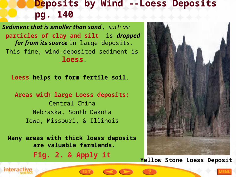
Deposits by Wind --Loess Deposits pg. 140
Sediment that is smaller than sand, such as:
particles of clay and silt is dropped far from its source in large deposits.
This fine, wind-deposited sediment is loess.
Loess helps to form fertile soil.
Areas with large Loess deposits:
Central China
Nebraska, South Dakota
Iowa, Missouri, & Illinois
Many areas with thick loess deposits are valuable farmlands.
Fig. 2. & Apply it Yellow Stone Loess Deposit

My Planet Diary!! Pg. 142
Have you ever seen a lake just disappear?
That’s what happened to Lake Jackson near Tallahassee, Florida, in 1999, and again in 2007.
The lake formed in two sinkholes that are usually plugged. But during a drought, the water level underground drops and the sinkholes open. In days, all the water in the lake may drain out. After the lake drained through Porter Hole in 1999 (shown here), people had a running race in the lake bottom!

What Landforms Are Found in Florida? Pg. 142
Did you know that no matter where you are in Florida, you’re NEVER more than 110 kilometers or closer to salt water.!!!
• About 25 million years ago, Florida was under water, and many of the state’s landforms are a result of the changing sea level.
The Florida peninsula sits on a huge limestone platform. Limestone is a sedimentary rock formed from the remains of tiny sea animals. When the animals died, their shells and skeletons sank to the bottom of the ocean and accumulated into layers. Over millions of years, these layers hardened into rock.
The size and shape of Florida changed repeatedly as sea levels rose and fell.

What Landforms Are Found in Florida? Pg. 143
Scientists have identified distinct regions in Florida where different landforms are found.
The three main regions are:
1.) The northern highlands
2.) The central highlands,
3.) The coastal lowlands.
Description of the 3 main regions
1. The northern highlands consist of gently sloping plateaus.
2. the central highlands are made up of long ridges.
3. The surrounding coastal lowlands include dunes and beaches on the Atlantic and Gulf coasts, as well as vast wetlands at the southern end of the peninsula.

Florida LandformsFig. 1 pg. 143Florida LandformMost of Florida is relatively flat, but over time the changing sea levels have shaped a varied landscape.
1.) Look at the diagram and notice the changes it shows in Florida’s coastline. Record yourobservations. ________________________________________________
2.) How have changing sea levels shaped Florida’s Landforms? ________________________________________________

Landforms Across Florida pg. 144
Over millions of years, ________ and _________ have shaped Florida’s landscape.
Different types of landforms in Florida include:
rivers, hills and ridges, coastal features, lakes, and wetlands.
Florida’s streams and rivers carry (erosion) and drop sediment along the coast, helping to form beaches, barrier islands, and
deltas (deposition).
Long, raised strips of land called ridges run parallel to the coast. Florida’s ridges mark ancient shorelines.
Waves and currents have shaped Florida’s long coastline, forming bays and building up sandbars and barrier islands.
Many southern Florida beaches consist of coral from offshore reefs.

Florida Landforms pgs. 144 & 145Landforms Across Florida
This map shows a few of Florida’s many landforms.

Landforms Across Florida pg. 145
There are more than 7,000
lakes across Florida, most of which formed after erosion dissolved the limestone plateau beneath them.
The Everglades is a large
wetland that covers several thousand square kilometers. The Everglades formed on a flat block of limestone that tilts gently toward the south.