table of contents - caltransdot.ca.gov/dist12/dea/i5hov/tr/water quality assessment report.pdf ·...
TRANSCRIPT


I-5 HOV Lane Extension Project i Water Quality Assessment Report
TABLE OF CONTENTS
ACRONYMS AND ABBREVIATIONS ................................................................................ iii EXECUTIVE SUMMARY ......................................................................................................vi 1 INTRODUCTION........................................................................................................... 1-1
1.1 Project Description ................................................................................................... 1-1 1.1.1 Alternative 1 – No Build................................................................................ 1-3 1.1.2 Alternative 2 ................................................................................................. 1-3 1.1.3 Alternative 3 ................................................................................................. 1-5 1.1.4 Alternative 4 ................................................................................................. 1-6 1.1.5 Approach to Water Quality Assessment ......................................................... 1-6
2 AFFECTED ENVIRONMENT ...................................................................................... 2-1 2.1 Surface Water Resources – Regional Hydrology....................................................... 2-1
2.1.1 San Juan Creek Watershed............................................................................ 2-3 2.1.2 San Clemente Coastal Streams Watershed..................................................... 2-3
2.2 Surface Water Resources – Local Hydrology............................................................ 2-3 2.3 Floodplains............................................................................................................... 2-5 2.4 Groundwater Resources............................................................................................ 2-5 2.5 Topography .............................................................................................................. 2-5 2.6 Climate..................................................................................................................... 2-5 2.7 Soils/Erosion Potential.............................................................................................. 2-6 2.8 Existing Water Quality ............................................................................................. 2-6 2.9 Highway Runoff Quality Assessment ....................................................................... 2-8
3 REGULATORY SETTING ............................................................................................ 3-1 3.1 Introduction .............................................................................................................. 3-1 3.2 Federal Requirements of the Clean Water Act........................................................... 3-1
3.2.1 Section 303 ................................................................................................... 3-1 3.2.2 Section 401 ................................................................................................... 3-1 3.2.3 Section 402 ................................................................................................... 3-1 3.2.4 Section 404 ................................................................................................... 3-2
3.3 State Water Quality Regulations ............................................................................... 3-2 3.3.1 Porter-Cologne Water Quality Control Act (Division 7 of the California Water
Code) ............................................................................................................ 3-2 3.3.2 California Toxics Rule .................................................................................. 3-2 3.3.3 California Fish and Game Code Section 1602............................................... 3-2
3.4 State Requirement under Section 402 of the CWA.................................................... 3-3 3.4.1 Construction General NPDES Permit ........................................................... 3-3 3.4.2 Caltrans Statewide NPDES Permit................................................................ 3-3 3.4.3 General Waste Discharge Requirements for De Minimus Discharges............ 3-5
3.5 Beneficial Uses......................................................................................................... 3-5 3.5.1 Beneficial Uses for Surface Waters ............................................................... 3-5 3.5.2 Beneficial Uses for Groundwater .................................................................. 3-7
3.6 Water Quality Objectives.......................................................................................... 3-7 3.6.1 Surface Water and Groundwater Quality Objectives ..................................... 3-7
3.7 List of 303(d) Impaired Waters................................................................................3-13

I-5 HOV Lane Extension Project ii Water Quality Assessment Report
4 ENVIRONMENTAL CONSEQUENCES...................................................................... 4-1 4.1 Potential Impacts to Water Quality ........................................................................... 4-1
4.1.1 Short-Term Impacts during Construction ...................................................... 4-1 4.1.2 Long-Term Impacts during Operation........................................................... 4-2
5 AVOIDANCE, MINIMIZATION, AND/OR MITIGATION MEASURES ................. 5-1 6 REFERENCES................................................................................................................ 6-1
FIGURES Figure 1-1: Project Location Map............................................................................................ 1-2 Figure 2-1: Watersheds ........................................................................................................... 2-2 Figure 2-2: Surface Waters...................................................................................................... 2-4 Figure 2-3: Box Whisker Plot with Data Points ....................................................................... 2-9 Figure 2-4: TSS Concentration Reduction ..............................................................................2-10 Figure 2-5: Total Zinc Concentration Reduction.....................................................................2-10 Figure 2-6: TSS Load Reduction ............................................................................................2-11 Figure 2-7: Total Zinc Load Reduction...................................................................................2-12
TABLES Table 2-1: Watershed Details .................................................................................................. 2-1 Table 2-2: Characterization Data from San Juan Creek and San Clemente Coastal Streams
Watersheds ............................................................................................................ 2-7 Table 2-3: Statewide Characterization Studies Data for Highway Facilities ............................. 2-8 Table 2-4: Effluent Expected Concentrations for BMP types ................................................... 2-9 Table 2-5: Load Reduction for BMP types (CTSW-RT-01-050).............................................2-11 Table 3-1: Design Pollution Prevention BMPs ........................................................................ 3-4 Table 3-2: Surface Water Beneficial Use Designations............................................................ 3-6 Table 3-3: Groundwater Beneficial Use Designations.............................................................. 3-7 Table 3-4: Surface Water and Groundwater Quality Objectives............................................... 3-7 Table 4-1: Estimated Disturbed Soil Area for Build Alternatives............................................. 4-1 Table 4-2: Estimated New Impervious Area for Build Alternatives ......................................... 4-3

I-5 HOV Lane Extension Project iii Water Quality Assessment Report
ACRONYMS AND ABBREVIATIONS
°F Degree(s) Fahrenheit
µg/L Micrograms per Liter AGR Agricultural Supply
amsl Above mean sea level Basin Plan San Diego RWQCB Water Quality Control Plan Basin Plan
BAT Best Available Technology BCT Best Conventional Pollutant Control Technology
BMPs Best Management Practices Caltrans California Department of Transportation
CDFG California Department of Fish and Game CEQA California Environmental Quality Act
CFR Code of Federal Regulations CGP Construction General Permit
Corps United States Army Corps of Engineers COLD Cold Freshwater Habitat
CTR California Toxics Rule CWA Clean Water Act DPP Design Pollution Prevention
DSA Disturbed Soil Area DDE Dichlorodiphenyldichloroethylene
EB Eastbound EPA United States Environmental Protection Agency
FEMA Federal Emergency Management Agency ft Foot or feet
GSRD Gross Solids Removal Devices HOV High Occupancy Vehicle
Kf Soil Erodibility Factor I-5 Interstate 5
IS/EA Initial Study/Environmental Assessment IND Industrial Service Supply
MEP Maximum Extent Practicable

I-5 HOV Lane Extension Project iv Water Quality Assessment Report
mg/L Milligrams per liter MBAS Methylene Blue-Activated Substances
mi Mile/miles mL Milliliter/milliliters
MUN Municipal and Domestic Supply N Nitrogen
NALs Numeric Action Levels NB Northbound
NH3 Ammonia No. Number
NO3 Nitrate NOI Notice of Intent
NOT Notice of Termination NPDES National Pollutant Discharge Elimination System
NRCS Natural Resources Conservation Service NWP Nationwide Permit
OCTA Orange County Transportation Authority OP Orthophosphate
PCH Pacific Coast Highway PCN Preconstruction notification
pH Percentage of hydrogen PM Post Mile
Porter-Cologne Act Porter-Cologne Water Quality Act PPDG Project Planning and Design Guide
PR Project Report PRD Project Registration Documents
PS&E Plans, Specifications, and Estimates PSR Project Study Report
REC-1 Contact Water Recreation REC-2 Non-contact Water Recreation
RWQCB Regional Water Quality Control Board SB Southbound
SWMP Stormwater Management Plan (Caltrans)

I-5 HOV Lane Extension Project v Water Quality Assessment Report
SWPPP Stormwater Pollution Prevention Plan SWRCB State Water Resources Control Board
TDS Total Dissolved Solids TKN Total Kjeldahl Nitrogen
TMDL Total Maximum Daily Load TSS Total Suspended Solids
UC Undercrossing WARM Warm Freshwater Habitat
WB Westbound WDR Waste Discharge Requirements
WILD Wildlife Habitat WQAR Water Quality Assessment Report
Zn Zinc

I-5 HOV Lane Extension Project vi Water Quality Assessment Report
EXECUTIVE SUMMARY
This Water Quality Assessment Report (WQAR) analyzes the potential water quality impacts of the proposed extension of the High Occupancy Vehicle (HOV) lanes along Interstate 5 (I-5) Project (project) in Orange County, Post Mile 3.0 to 8.7. It analyzes the existing conditions in the project area, surrounding the project area, and the water quality control measures that will be implemented to reduce impacts.
The California Department of Transportation (Caltrans) District 12 proposes to widen I-5 in Orange County, between the Avenida Pico Undercrossing (southern project limit) to south of the San Juan Creek Road Undercrossing (northern project limit). Alternative 1 is the No Build Alternative, where no improvements would be implemented. Alternative 2 would widen I-5 in the northbound and southbound directions to accommodate the HOV lane, improve the Avenida Pico interchange, install new auxiliary lanes, modify on- and off-ramps, widen bridge structures within the project limits, and improve the existing curve. Alternative 3 would be similar to Alternative 2, except it would only improve the northbound portion of the existing curve. Alternative 4 would be similar to Alternatives 2 and 3, except it proposes no buffer instead of the four-foot buffer in Alternatives 2 and 3, and improvements to the compound curve and median.
The project would assist in improving the level of service provided by the existing facilities, minimize right-of-way acquisitions, and relieve and reduce congestion. This proposed project discharges to San Juan Creek, Prima Deshecha Cañada, and Segunda Deshecha Cañada, which are listed as impaired on the 2006 Clean Water Act (CWA) Section 303(d) List of Water Quality Limited Segments for various pollutants, including San Juan Creek, for indicator bacteria and the toxic chemical, dichlorodiphenyldichloroethylene (DDE), and Prima Deshecha Cañada and Segunda Deshecha Cañada, for phosphorus and turbidity.
The short-term impacts of construction would include an estimated disturbed soil area of 126.1 acres to 134.4 acres (see Table 4-1) depending on the alternative selected, potential groundwater dewatering to construct the bridge structure footings and culvert extensions, and generating pollutants of concern such as sediment, trash, petroleum products, concrete waste, sanitary waste, and chemicals. A Stormwater Pollution Prevention Plan (SWPPP), which is prepared for projects greater than one acre, will be prepared and implemented during construction of the proposed project. It identifies specific best management practices (BMPs) that will be implemented during project construction. Furthermore, BMPs implemented as a part of the project would meet the technology requirements as stipulated in the National Pollutant Discharge Elimination System (NPDES) Construction General Permit (CGP) and Caltrans’ NPDES Permit.
The project would result in new impervious area of 16.5 acres to 19.9 acres (see Table 4-2) depending on the alternative selected. The long-term impact of expanding the impervious area would increase the volume of runoff during a storm, which could result in the potential transport of pollutants to receiving waters. Caltrans-approved Treatment BMPs could include but are not limited to biofiltration swales, biofiltration strips, infiltration trenches, and detention basins. An infiltration basin may be considered if soil conditions allow and prescribed groundwater level clearances are achievable. The selection of specific BMPs is also subject to finding suitable locations.
Measures that the project must comply with include:

I-5 HOV Lane Extension Project vii Water Quality Assessment Report
WQ-1 (Compliance with Caltrans’ NPDES Permit and Construction General Permit); WQ-2 (Develop a Stormwater Pollution Prevention Plan (SWPPP) and implement its
construction site BMPs); WQ-3 (Adhere to Dewatering Permit requirements); WQ-4 (Implement Treatment BMPs); and WQ-5 (Implement Design Pollution Prevention BMPs).
With the implementation of the identified measures, the project construction, design, and facility operation will comply with the requirements of Caltrans’ NPDES permit and Stormwater Management Plan, and applicable general NPDES permits.

I-5 HOV Lane Extension Project 1-1 Water Quality Assessment Report
1 INTRODUCTION This Water Quality Assessment Report (WQAR) analyzes the potential water quality impacts of the four alternatives on the existing conditions of the surrounding project area and the water quality control measures that will be taken to avoid and/or minimize these impacts. This chapter describes the proposed project alternatives, as well as an overview of the water quality assessment used to evaluate the potential impacts related to project implementation.
1.1 Project Description The Orange County Transportation Authority (OCTA), in cooperation with the California Department of Transportation (Caltrans), the City of Dana Point, the City of San Clemente, and the City of San Juan Capistrano, is proposing to widen Interstate 5 (I-5) between Avenida Pico and San Juan Creek Road. The project objectives are to provide continuity of the I-5 mainline high-occupancy vehicle (HOV) network within the project limits; maximize overall performance within the project limits by minimizing weaving conflicts at the termini of the HOV lanes and maintaining travel speeds for HOV lane users; provide intermittent auxiliary lanes, where needed, to relieve congestion at diverge and merge locations; minimize right-of-way acquisition; relieve congestion within interchange areas, on- and off-ramps, and local intersections; and reduce congestion on I-5 within the project limits. The project limits on I-5 extend from 0.4 mile (mi) south of the Avenida Pico Undercrossing (UC) (Post Mile [PM] 3.0) to 0.1 mi south of the San Juan Creek Road UC (PM 8.7). The proposed project will add one HOV lane in each direction on I-5 throughout the project limits, reestablish existing auxiliary lanes and construct new auxiliary lanes, and improve several existing on- and off-ramps.
Four alternatives, including the No Build Alternative, will be analyzed as part of the Draft Initial Study/Environmental Assessment (IS/EA). The project alternatives are described below.
Figure 1-1 shows the location of the project.

I-5 HOV Lane Extension Project 1-2 Water Quality Assessment Report
Figure 1-1: Project Location Map

I-5 HOV Lane Extension Project 1-3 Water Quality Assessment Report
1.1.1 Alternative 1 – No Build The No Build Alternative proposes no improvements to I-5, maintaining the existing four general-purpose lanes throughout the project limits in the northbound (NB) and southbound (SB) directions. All freeway facilities would remain as is, with the exception of proposed projects that are under development or currently in construction.
1.1.2 Alternative 2 Auxiliary Lanes Alternative 2 proposes to remove the existing I-5 paved shoulders and construct new traveled way and new shoulder pavement to the outside of the NB and SB lanes to accommodate HOV lanes. This alternative proposes full standard widths, including a 10-foot (ft) inside shoulder, 12-ft HOV lane, 4-ft buffer, four 12-ft general-purpose lanes, and a 10-ft outside shoulder throughout the majority of the project limits. Additionally, existing auxiliary lanes through the project limits are proposed to be reestablished, and new auxiliary lanes will be constructed at the following locations (at the specified lengths):
To Avenida Vista Hermosa SB off-ramp (1,300 ft) From Avenida Vista Hermosa NB on-ramp (1,600 ft) From Camino de Estrella SB on-ramp (1,600 ft)
Avenida Pico Interchange Improvements In addition to providing an HOV lane through the I-5/Avenida Pico interchange, the interchange configuration will also be improved. There are two options under consideration for reconfiguration of the interchange, both of which require replacement of the Avenida Pico Overcrossing structure.
Design Option A – Modified Tight Diamond Interchange Under this option, the on- and off-ramps at Avenida Pico will be realigned and the NB on-ramp will be widened to three lanes. The overall configuration of the interchange will be similar to the existing configuration. Additionally, Avenida Pico will be improved under the structure to provide dual left-turn lanes to both the NB and SB on-ramps. This alternative will incorporate an interconnect line to optimize signal timing and operations for the closely spaced intersections at the interchange. The geometry of Avenida Pico will also be improved on the east side of I-5 to remove the existing reversing curves. Bicycle lanes and standard outside shoulders will be provided throughout the majority of the interchange in both the eastbound (EB) and westbound (WB) directions. Sidewalk will be provided through the interchange in the EB direction. In the WB direction, space will be provided to accommodate future construction of a 12 ft lane and sidewalk through the interchange.

I-5 HOV Lane Extension Project 1-4 Water Quality Assessment Report
Design Option B – NB Loop On-Ramp/Realigned NB Off-Ramp Under this option, a NB loop on-ramp will be added to allow for the removal of the existing left-turn lane for traffic heading eastward on Avenida Pico to access NB I-5. The existing directional on-ramp would remain in place for traffic heading WB to access NB I-5. Additionally, the NB off-ramp would be reconfigured around the loop, resulting in a partial cloverleaf configuration. The SB ramps will be realigned, and the geometry of Avenida Pico will be improved as proposed in Design Option A. Dual left-turn lanes will be provided under the structure to the SB on-ramp. Bicycle lanes and standard outside shoulders will be provided throughout the majority of the interchange in both the EB and WB directions. Sidewalk will be provided through the interchange in the EB direction. In the WB direction, space will be provided to accommodate future construction of a 12 ft lane and sidewalk through the interchange.
Ramps All ramps within the project limits will be modified in order to accommodate the HOV lanes, which include improvements ranging from restriping to complete reconstruction. Specifically, ramp modifications under this alternative include:
Avenida Pico Modify ramps as described in Design Options A and B above
Avenida Vista Hermosa Restripe NB and SB loop on-ramps Restripe and reconstruct NB on- and off-ramps and SB off-ramp
Camino de Estrella Realign, reconstruct and widen SB off-ramp to a two-lane ramp Realign and reconstruct NB and SB on-ramps and NB loop on-ramp Realign NB off-ramp
Camino Las Ramblas/Pacific Coast Highway (PCH) Realign, reconstruct and widen SB PCH to SB I-5 connector to a two-lane connector Realign and reconstruct SB loop on-ramp Realign SB off-ramp and NB on- and off-ramps Realign NB I-5 connector
Camino Capistrano (Stonehill Drive) Realign and reconstruct NB on-ramp
Structures Via California
Reduced shoulder widths are proposed under the Via California structure in order to avoid replacement of the existing Via California Overcrossing (Bridge No. 55-225). The inside shoulder is reduced to approximately four feet at the minimum location and the HOV buffer is eliminated in the NB direction.
Avenida Pico

I-5 HOV Lane Extension Project 1-5 Water Quality Assessment Report
This alternative also proposes to replace the Avenida Pico UC structure (Bridge No. 55-205) to accommodate the HOV lane in each direction through the interchange. In order to achieve minimum vertical clearance for this structure, the I-5 mainline profile will be raised through the interchange area. Additionally, to ensure that all existing mainline lanes are open through construction, the I-5 centerline will be realigned westward approximately 20 ft through the interchange.
Avenida Vaquero UC (Bridge No. 55-223) Structure widening
NB I-5 to NB PCH Connector (Bridge No. 55-226) Structure widening
Route 5/Camino Las Ramblas UC (Bridge No. 55-510) Structure Widening
Camino Capistrano UC (Stonehill Drive) (Bridge No. 55-227L and 55-227R) Structure Widening
Other Improvements Alternative 2 proposes to improve the existing compound curve between 0.3 miles south of Stonehill Drive and PCH. This alternative would provide a wide inside shoulder (26 ft at the maximum width) throughout the southern portion of the curve along with increasing the radius from 2,000-ft to 2,200-ft to accommodate full standard stopping sight distance in the SB direction. For the northern portion of the curve, the existing radius is increased from 3,200-ft to 3,300-ft, with a 16-ft shoulder, in order to achieve standard stopping sight distance through this portion of the compound curve. To accommodate the improvements to this compound curve, the median will be reconstructed.
1.1.3 Alternative 3 Alternative 3 is very similar in nature to Alternative 2. The differences are noted.
Auxiliary Lanes New auxiliary lanes will be constructed at the same locations as noted in Alternative 2.
Avenida Pico Interchange Improvements Design options for the Avenida Pico interchange reconfiguration will be the same as those noted under Alternative 2.
Ramps Ramp modifications will be the same as those noted under Alternative 2 with the
exception of the Camino Capistrano (Stonehill Drive) ramp, which will not be impacted.
I-5 HOV Lane Extension Project 1-6 Water Quality Assessment Report
Structures Modifications and improvements to structures are the same as those noted under Alternative 2, with the exception that I-5 NB Camino Capistrano UC (Stonehill Drive) (Bridge No. 55-227R) will not be widened.
Other Improvements Unlike Alternative 2, in Alternative 3, for the northern portion of the compound curve, the existing radius would not be changed and a 2-ft median shoulder would be provided, resulting in a nonstandard stopping sight distance. To accommodate the improvements to this compound curve, the median will be reconstructed.
1.1.4 Alternative 4 Alternative 4 includes many of the improvements common to Alternatives 2 and 3 with a few modifications. Alternative 4 proposes no buffer instead of the 4-ft buffer proposed in Alternatives 2 and 3. Under the no buffer scenario, the HOV lane will accommodate continuous access throughout the project limits.
Auxiliary Lanes New auxiliary lanes will be constructed at the same locations as noted in Alternatives 2 and 3.
Avenida Pico Interchange Improvements Design options for the Avenida Pico interchange reconfiguration will be the same as those noted under Alternative 2 and 3.
Ramps Ramp modifications will be the same as those noted under Alternative 3.
Structures Modifications and improvements to structures are the same as those noted under Alternative 3.
Other Improvements Unlike Alternatives 2 and 3, for the northern portion of the compound curve, the existing radius would not be changed and a standard 10-ft median shoulder would be provided, which would minimize impacts but results in a non-standard stopping sight distance condition. To accommodate the improvements to this compound curve, the median will be reconstructed.
1.1.5 Approach to Water Quality Assessment To determine the potential temporary and permanent water quality impacts of the project, the following factors will be analyzed and assessed:
I-5 HOV Lane Extension Project 1-7 Water Quality Assessment Report
Pollutant sources and anticipated changes in concentration of point-source pollutants due to changes in land use;
Pre-project and post-project impervious areas and changes after project completion and in relation to the amount of runoff (and whether it increases or decreases);
Potential temporary impacts during construction of the project; BMP technology types and their efficiency; Amounts and types of discharges into impaired waters (as listed in Section 303(d) of the
federal Clean Water Act [CWA]); and Existing water quality regulations and Caltrans methods of compliance.
Applicable federal and state laws and regulations addressed in this report include: Federal Laws
CWA State Laws
Porter-Cologne Water Quality Act California Toxics Rule (CTR)

I-5 HOV Lane Extension Project 2-1 Water Quality Assessment Report
2 AFFECTED ENVIRONMENT
2.1 Surface Water Resources – Regional Hydrology The project area drains to the San Juan Creek and San Clemente Coastal Streams watersheds. The subwatersheds of the San Clemente Coastal Streams Watershed are named Prima Deshecha Cañada and Segunda Deshecha Cañada. Table 2-1 identifies the area and the estimated impervious area (percentage) of the watersheds.
Table 2-1: Watershed Details
Watershed Name
Subwatershed Name
Area (square miles)
Estimated Impervious Area (percentage)
San Juan Creek Not Applicable 177 30%
Prima Deshecha Cañada 8 60% San Clemente Coastal
Streams Segunda Deshecha Cañada 11 60%
Source: United States Army Corps of Engineers Watershed Management Study and California Department of Fish and Game Geographic Information Systems data Figure 2-1 identifies the watersheds to which this project drains.

P a c i f i c O c e a n
Project Location
%&l(
?¥
Aß
?±
A¾
!"̂$
!"̂$
!"a$
?Ò
Aß
LegendHighwayProject BoundarySan Clemente Coastal Streams WatershedSan Juan Creek WatershedPrima Deshecha Canada WatershedSegunda Deshecha Canada Watershed
Figure 2-1: Watersheds
±0 3 61.5
Miles
M:\M
data\
1010
6626
\GIS
\WQA
_Wtrs
hds.m
xd

I-5 HOV Lane Extension Project 2-3 Water Quality Assessment Report
2.1.1 San Juan Creek Watershed The San Juan Creek Watershed originates in the Santa Ana Mountains, which are also part of the Cleveland National Forest. It begins in unincorporated Orange County and flows through the cities of Dana Point, Laguna Hills, Laguna Niguel, Mission Viejo, Rancho Santa Margarita, San Clemente, and San Juan Capistrano. The project drains to the Lower San Juan Creek portion of the watershed in the cities of Dana Point and San Juan Capistrano. Approximately 0.9 miles of the roadway improvements are within this watershed. The channel downstream of the project is an engineered soft-bottom channel and extends to the Pacific Ocean.
2.1.2 San Clemente Coastal Streams Watershed The San Clemente Coastal Streams Watershed encompasses two subwatersheds, Prima Deshecha Cañada and Segunda Deshecha Cañada. Cascadita Creek is a tributary creek to Prima Deshecha Cañada. The high point for Prima Deshecha Cañada and Segunda Deshecha Cañada is located in an area of coastal foothills, identified by the United States Geological Survey as Boca de la Playa, which is also in unincorporated Orange County. Prima Deshecha Cañada drains through the cities of San Clemente and the Capistrano Beach area of Dana Point, then confluences with the Pacific Ocean. Segunda Deshecha Cañada flows through unincorporated Orange County land and the City of San Clemente en route to the Pacific Ocean. Approximately three miles of the roadway improvements are within this watershed. The channel downstream of the project is an engineered soft-bottom channel and extends to the Pacific Ocean.
2.2 Surface Water Resources – Local Hydrology Within the project limits, runoff from I-5 discharges into drainage inlets, which discharge to Lower San Juan Creek, Prima Deshecha Cañada, Segunda Deshecha Cañada, and Cascadita Creek via various culverts, which convey flows to the Pacific Ocean via engineered channels. Annual flows in the creeks vary greatly in any given year, and they are typically at their peak during the winter and spring seasons. The project intersects all three subwatersheds approximately one mile prior to their confluence with the Pacific Ocean. Figure 2-2 identifies the surface waters within the vicinity of the project.

P a c i f i c O c e a n
?±
!"̂$
!"̂$
?Ò
LegendHighwaySurface Water BodiesProject BoundarySan Clemente Coastal Streams WatershedSan Juan Creek WatershedPrima Deshecha Canada WatershedSegunda Deshecha Canada Watershed
Figure 2-2: Surface Waters
±0 0.5 10.25
Miles
San J
uan C
reek
Arroyo Trabuco
Cascadi
ta Cree
kPrima D
eshech
a Cana
da
Segund
a Desh
echa C
anada
M:\M
data\
1010
6626
\GIS
\WQA
_Surf
aceW
aters.
mxd

I-5 HOV Lane Extension Project 2-5 Water Quality Assessment Report
2.3 Floodplains The project intersects two watersheds, San Juan Creek and San Clemente Coastal Streams, and is located within the 100-year floodplain (Zone AE) of San Clemente Coastal Streams only. Within the San Juan Creek Watershed, the project is not in the 100-year floodplain (Zone AE)1. Prima Deshecha Cañada and Segunda Deshecha Cañada are crossed by the project in the San Clemente Coastal Streams Watershed. Prima Deshecha Cañada2 and Segunda Deshecha Cañada3 are box channels underground, but are within the 100-year floodplain (Zone AE). The project is not expected to disturb or change the floodplain limits. No other portion of the project is within a floodplain. A Location Hydraulics Report will be prepared in accordance with Caltrans’ requirements.
2.4 Groundwater Resources The San Diego Regional Water Quality Control Board (RWQCB) classified the groundwater basins the project is located in as the Mission Viejo and San Clemente Hydrologic Areas, specifically the Lower San Juan, Prima Deshecha, and Segunda Deshecha Hydrologic Subareas. All the hydrologic areas are located in the San Juan Hydrologic Unit. The United States Army Corps of Engineers (Corps) conducted a feasibility analysis to address the management plans of the San Juan Creek Watershed. The feasibility analysis states that the estimated storage capacity for the San Juan Creek Groundwater Basin is 90,000 acre-feet and natural recharge from streambed percolation, rainfall infiltration, deep percolation, and subsurface inflow, is greater than approximately 10,500 acre-feet (Corps, 2002). Groundwater depths at the lower Ortega Highway Bridge, which is just north of the project, were found to be less than 6 meters (20 feet) (Corps, 2002). No specific information on the San Clemente Coastal Streams Watershed was identified. The project is a roadway improvement project downstream of the recharge facilities and is not expected to alter the groundwater recharge facilities. Since this project is in the initial planning phase, geotechnical studies have not been conducted, but will be conducted prior to beginning the design phase.
2.5 Topography I-5 varies in elevation throughout the project, from 74.6 feet above mean sea level (amsl) near the Camino Capistrano on-ramps and off-ramps, to 218.8 feet amsl near the project’s intersection with Camino de los Mares.
2.6 Climate The climate is classified as Mediterranean; generally dry in the summer with mild, wet winters. The average annual precipitation in the project limits is approximately 12 to 14 inches4, with
1 Federal Emergency Management Agency (FEMA) Flood Insurance Rate Map, December 2009 – 06059C0506J, for the intersection of I-5 and Stonehill Drive. 2 FEMA Flood Insurance Rate Maps, December 2009 – 06059C0509J, for the intersection of I-5 with Prima Deshecha Cañada. 3 FEMA Flood Insurance Rate Maps, December 2009 – 06059C0528J and 06059C0536J, for the intersection of I-5 and Segunda Deshecha Cañada. 4 California Coastal Conservancy, Southern California Coastal Watershed Inventory, San Juan Hydrologic Unit

I-5 HOV Lane Extension Project 2-6 Water Quality Assessment Report
most of the precipitation occurring from November to May. The 85th percentile storm event in this region is 0.7 inches.
2.7 Soils/Erosion Potential The Soil Erodibility Factor (Kf) within the project limit ranges from 0.17 to 0.55, according to Natural Resources Conservation Service (NRCS) soil survey data. Generally, this equates to a high potential for erosion within the project area. However, this is a planning-level tool, so a detailed site-specific survey is still required for design-level analysis. The Kf represents:
Susceptibility of soil or surface material to erosion Transportability of the sediment The amount and rate of runoff given a particular rainfall input, as measured under a
standard condition.
In general, fine-textured soils that are high in clay have low K values (approximately 0.05 to 0.15) because the particles are resistant to detachment. Coarse-textured soils, such as sandy soils, also have low K values (approximately 0.05 to 0.20) because of high infiltration, resulting in low runoff even though these particles are easily detached. Medium-textured soils, such as a silt loam, have moderate K values (approximately 0.25 to 0.45) because they are moderately susceptible to particle detachment and they produce runoff at moderate rates. Refer to the NRCS soil data1 for more information.
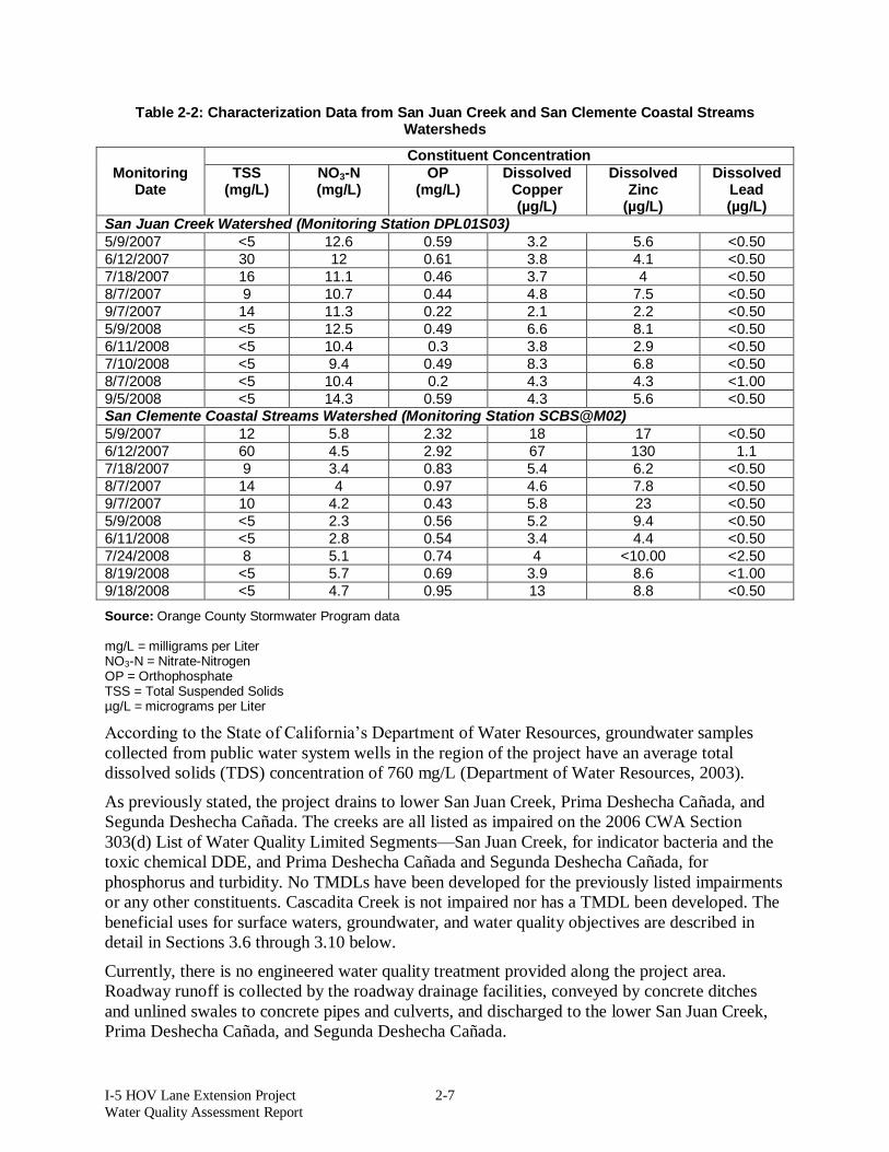
2.8 Existing Water Quality The Orange County Stormwater Program has historically monitored the water quality of San Juan Creek and the San Clemente Coastal Streams. All available data and monitoring locations were researched to determine whether in-stream monitoring data was available near the project limits. The closest in-stream monitoring stations are downstream of the project, one in the San Juan Creek Watershed and one in the San Clemente Coastal Streams Watershed. Table 2-2 presents data compiled from monitoring conducted during the fiscal year 2007–2008.
Profile, accessed via http://wrpinfo.scc.ca.gov/watersheds/briefs/sanjuan/index.html on November 18, 2009. 1 United States Department of Agriculture, Natural Resources Conservation Service, Web Soil Survey, http://websoilsurvey.nrcs.usda.gov/app
I-5 HOV Lane Extension Project 2-7 Water Quality Assessment Report
Table 2-2: Characterization Data from San Juan Creek and San Clemente Coastal Streams Watersheds
Constituent Concentration Monitoring
Date TSS
(mg/L) NO3-N (mg/L)
OP (mg/L)
Dissolved Copper (µg/L)
Dissolved Zinc
(µg/L)
Dissolved Lead (µg/L)
San Juan Creek Watershed (Monitoring Station DPL01S03) 5/9/2007 <5 12.6 0.59 3.2 5.6 <0.50 6/12/2007 30 12 0.61 3.8 4.1 <0.50 7/18/2007 16 11.1 0.46 3.7 4 <0.50 8/7/2007 9 10.7 0.44 4.8 7.5 <0.50 9/7/2007 14 11.3 0.22 2.1 2.2 <0.50 5/9/2008 <5 12.5 0.49 6.6 8.1 <0.50 6/11/2008 <5 10.4 0.3 3.8 2.9 <0.50 7/10/2008 <5 9.4 0.49 8.3 6.8 <0.50 8/7/2008 <5 10.4 0.2 4.3 4.3 <1.00 9/5/2008 <5 14.3 0.59 4.3 5.6 <0.50 San Clemente Coastal Streams Watershed (Monitoring Station SCBS@M02) 5/9/2007 12 5.8 2.32 18 17 <0.50 6/12/2007 60 4.5 2.92 67 130 1.1 7/18/2007 9 3.4 0.83 5.4 6.2 <0.50 8/7/2007 14 4 0.97 4.6 7.8 <0.50 9/7/2007 10 4.2 0.43 5.8 23 <0.50 5/9/2008 <5 2.3 0.56 5.2 9.4 <0.50 6/11/2008 <5 2.8 0.54 3.4 4.4 <0.50 7/24/2008 8 5.1 0.74 4 <10.00 <2.50 8/19/2008 <5 5.7 0.69 3.9 8.6 <1.00 9/18/2008 <5 4.7 0.95 13 8.8 <0.50
Source: Orange County Stormwater Program data mg/L = milligrams per Liter NO3-N = Nitrate-Nitrogen OP = Orthophosphate TSS = Total Suspended Solids µg/L = micrograms per Liter
According to the State of California’s Department of Water Resources, groundwater samples collected from public water system wells in the region of the project have an average total dissolved solids (TDS) concentration of 760 mg/L (Department of Water Resources, 2003).
As previously stated, the project drains to lower San Juan Creek, Prima Deshecha Cañada, and Segunda Deshecha Cañada. The creeks are all listed as impaired on the 2006 CWA Section 303(d) List of Water Quality Limited Segments—San Juan Creek, for indicator bacteria and the toxic chemical DDE, and Prima Deshecha Cañada and Segunda Deshecha Cañada, for phosphorus and turbidity. No TMDLs have been developed for the previously listed impairments or any other constituents. Cascadita Creek is not impaired nor has a TMDL been developed. The beneficial uses for surface waters, groundwater, and water quality objectives are described in detail in Sections 3.6 through 3.10 below.
Currently, there is no engineered water quality treatment provided along the project area. Roadway runoff is collected by the roadway drainage facilities, conveyed by concrete ditches and unlined swales to concrete pipes and culverts, and discharged to the lower San Juan Creek, Prima Deshecha Cañada, and Segunda Deshecha Cañada.

I-5 HOV Lane Extension Project 2-8 Water Quality Assessment Report
2.9 Highway Runoff Quality Assessment Table 2-3 presents the concentrations of typical pollutants found on state highways based on the monitoring conducted as part of Caltrans’ Statewide Characterization Study.
Table 2-3: Statewide Characterization Studies Data for Highway Facilities
Constituent Concentration
TSS 112.7 mg/L NO3-N 1.07 mg/L TKN 2.06 mg/L Ortho-phosphate 0.11 mg/L Particulate Phosphorus 0.18 mg/L Dissolved Copper 14.9 ug/L Dissolved Zinc 68.8 ug/L Dissolved Lead 7.6 ug/L Total Copper 33.5 ug/L Total Zinc 187.1 ug/L Total Lead 68.8 ug/L
Source: Caltrans Discharge Characterization Study Report (CTSW-RT-03-065.51.42) mg/L = milligrams per liter NO3-N = nitrate-nitrogen TKN = total Kjeldahl nitrogen TSS = total suspended solids ug/L = micrograms per liter
The box-whisker plot, shown in Figure 2-3, represents all of the data points. The plots provide insight into the variability of performance within each BMP type and possible differences in performance among the types.
The box represents 50% of the data points, as well as the median value of all the data points (i.e., the median falls within the 75th and 25th percentile of data [top and bottom of the box]). The whisker extends to the highest point within a range of 1.5 times the difference between the first and third quartiles.

I-5 HOV Lane Extension Project 2-9 Water Quality Assessment Report
Figure 2-3: Box Whisker Plot with Data Points
Table 2-4, Figure 2-4, and Figure 2-5 show the observed effluent concentrations for several different types of BMPs for the constituents of total suspended solids (TSS) and zinc. These data were generated in an extensive field program conducted by Caltrans. The study is unique in that many of the BMPs were tested under reasonably similar conditions (climate, storms, freeway stormwater quality), with each type of BMP sized with the same design criteria.
Table 2-4: Effluent Expected Concentrations for BMP types
Device TSS (Influent 112.7 mg/L)
Total Zn (Influent 187.1 ug/L)
Detention Devices-unlined 35.7 102.9 Infiltration Basin 0 0 Infiltration Trench 0 0 Biofiltration Swale 58.4 62.0 Biofiltration Strip 27.5 60.5
Source: Caltrans BMP Retrofit Pilot Program - Final Report (CTSW-RT-01-050) BMP = Best Management Practices mg/L = milligrams per Liter TSS = Total Suspended Solids ug/L = micrograms per Liter

I-5 HOV Lane Extension Project 2-10 Water Quality Assessment Report
Figure 2-4: TSS Concentration Reduction
0.010.020.030.040.050.060.070.080.0
Swal
es
Strip
s
Infil
trat
ion
Tren
ch
Unlin
ed
EDB
Infil
tratio
n
Basi
n
TSS
(mg/
L)
Source: Caltrans BMP Retrofit Pilot Program - Final Report (CTSW-RT-01-050)
Figure 2-5: Total Zinc Concentration Reduction
0.0
20.0
40.0
60.0
80.0
100.0
120.0
Swal
es
Strip
s
Infil
trat
ion
Tren
ch
Unl
ined
ED
B
Infil
trat
ion
Bas
in
Tota
l Zn
(ug/
L)
Source: Caltrans BMP Retrofit Pilot Program - Final Report (CTSW-RT-01-050)

I-5 HOV Lane Extension Project 2-11 Water Quality Assessment Report
Table 2-5, Figure 2-6, and Figure 2-7 present the load reduction for the BMP types proposed for implementation on I-5. These are based on the results of Caltrans’ BMP Retrofit Pilot Study. Infiltration was observed in strips, swales, and detention devices that will reduce the pollutant load to the receiving water body.
Table 2-5: Load Reduction for BMP types (CTSW-RT-01-050)
Device TSS Total Zinc Detention Devices-unlined 78% 61% Infiltration Basin 100% 100% Infiltration Trench 100% 100% Biofiltration Swale 73% 82% Biofiltration Strip 83% 81%
Source: Caltrans BMP Retrofit Pilot Program - Final Report (CTSW-RT-01-050)
BMP = best management practice TSS = total suspended solids
Figure 2-6: TSS Load Reduction
0%
20%
40%
60%
80%
100%
Swal
es
Strip
s
Infil
tratio
n
Tren
ch
Unlin
ed
EDB
Infil
tratio
n
Basi
n
TSS
Load
Red
uctio
n
Source: Caltrans BMP Retrofit Pilot Program - Final Report (CTSW-RT-01-050)

I-5 HOV Lane Extension Project 2-12 Water Quality Assessment Report
Figure 2-7: Total Zinc Load Reduction
0%
20%
40%
60%
80%
100%
Swal
es
Strip
s
Infil
tratio
n
Tren
ch
Unlin
ed
EDB
Infil
tratio
n
Basi
n
Zinc
Loa
d R
educ
tion
Source: Caltrans BMP Retrofit Pilot Program - Final Report (CTSW-RT-01-050)
Comparing the expected effluent concentrations for TSS from approved treatment BMPs (Table 2-3) to the existing water quality data in Table 2-2 shows that runoff concentrations are lower than typical highway runoff conditions. However, the concentrations for nitrate-nitrogen, orthophosphate, and a couple of the dissolved copper data points are higher than typical highway runoff conditions. For the past several years, Caltrans’ Stormwater Research and Monitoring Program has collected water quality data from over 100 highway runoff monitoring sites. The majority of this data has been collected from highways in Southern California. Based on this monitoring program, roadways typically generate the following potential or expected pollutants:
Sediment/turbidity (expected) Nutrients, including ammonia, nitrate as nitrogen, TKN, total phosphorus, dissolved
ortho-phosphate (minor potential – if landscaping or if fertilizer is used on the project site)
Organic compounds, including TDS, TSS, dissolved organic carbon, and total organic carbon (expected – specifically, petroleum hydrocarbons)
Trash and debris (expected) Bacteria and viruses (minor potential, but generally not expected in runoff from
roadways) Oil and grease (expected) Metals, including copper, lead, and zinc (expected)

I-5 HOV Lane Extension Project 2-13 Water Quality Assessment Report
Treatment BMPs have varying levels of effectiveness treating specific pollutants. The above constituents need to be considered when developing appropriate water quality treatments for this proposed project.

I-5 HOV Lane Extension Project 3-1 Water Quality Assessment Report
3 REGULATORY SETTING
3.1 Introduction While carrying out its mission to plan, develop, maintain, and manage interregional transportation in California, Caltrans’ policy is to protect and enhance the environment and quality of life in accordance with the environmental, economic, and social goals of the state. With its SWMP, implemented via Caltrans’ Stormwater Management Program, Caltrans intends to prevent the adverse effects of stormwater runoff from Caltrans roadways and facilities.
Discharges into waters of the United States are subject to the regulatory requirements under the following:
Sections 303, 401, 402, and 404 of the federal CWA California Porter-Cologne Water Quality Control Act (Porter-Cologne Act) California Department of Fish and Game (CDFG) under Section 1602 of the California
Fish and Game Code CTR
3.2 Federal Requirements of the Clean Water Act
3.2.1 Section 303 Section 303 of the CWA requires that the state adopt water quality objectives for surface waters. The San Diego RWQCB Water Quality Control Plan (Basin Plan) contains water quality objectives that are considered necessary to protect the specific beneficial uses it identifies. Section 303(d) specifically requires the state to develop a list of impaired water bodies and subsequent numeric TMDLs for constituents that impair a particular water body. These constituents include:
Indicator Bacteria DDE Phosphorus Turbidity
3.2.2 Section 401 Section 401 of the CWA specifies that any applicant for a federal license or permit to conduct any activity (including but not limited to the construction or operation of facilities that may result in any discharge into navigable water) shall provide the federal licensing or permitting agency with a certification. The certification must be issued by the state agency with jurisdiction over the waters from which the discharge originates or will originate. In this case, the state agency is the San Diego RWQCB. The certification must convey that the project will comply with water quality standards, including beneficial uses, water quality objectives, and the state antidegradation policy. The project will require a Section 401 certification for its disturbance to waters of the United States and waters of the State.
3.2.3 Section 402 Direct discharges of pollutants into waters of the United States are not allowed, except in accordance with the NPDES program established in Section 402 of the CWA. The main goal of

I-5 HOV Lane Extension Project 3-2 Water Quality Assessment Report
the NPDES program is to protect human health and the environment. Pursuant to the NPDES program, permits that apply to stormwater discharges from municipal storm drain systems, specific industrial activities, and construction activities that disturb one acre or more have been issued. NPDES permits establish enforceable effluent limitations on discharges, require monitoring of discharges, designate reporting requirements, and require the permittee to implement BMPs. Stormwater discharge from Caltrans’ roadways are regulated by its Statewide NPDES permit and are governed by the maximum extent practicable (MEP) or the BAT/BCT application of BMPs.
3.2.4 Section 404 The Corps regulates discharges or fills into waters of the United States under Section 404 of the CWA via a nationwide permit (NWP) or an individual permit program. Several categories of NWPs can be used for projects that fall under specific categories. A preconstruction notification (PCN) to the Corps district engineer is required for most activities that result in the loss of greater than 0.01 acre of waters of the United States. The Corps reviews the PCN on a case-by-case basis to determine whether the adverse effects of the proposed work on the aquatic environment are minimal. The Corps will also determine whether a particular drainage is considered discharging to waters of the United States and subject to regulation under Section 404. The project will result in a disturbance to waters of the United States and will comply with the conditions issued by the Corps per the Section 404 permit.
3.3 State Water Quality Regulations
3.3.1 Porter-Cologne Water Quality Control Act (Division 7 of the California Water Code) The Porter-Cologne Act established a regulatory program to protect water quality and beneficial uses of state waters. It empowers each RWQCB to formulate and adopt, for all areas within its jurisdiction, a Basin Plan that designates beneficial uses and establishes water quality objectives that in its judgment will ensure reasonable protection of beneficial uses. Each RWQCB establishes water quality objectives that will ensure the reasonable protection of beneficial uses and the prevention of nuisance. The California Water Code provides flexibility for some change in water quality, provided beneficial uses are not adversely affected.
3.3.2 California Toxics Rule The CTR was put into effect by the United States Environmental Policy Act on May 18, 2000 and established federal numeric water quality criteria for certain priority toxic pollutants for inland surface waters, enclosed bays, and estuaries for all purposes and programs under the CWA. The CTR applies the federal criteria requirement to waters of the state.
3.3.3 California Fish and Game Code Section 1602 The CDFG, through provisions of the California Fish and Game Code Section 1602, is empowered to issue agreements for any alteration of a river, stream, or lake where fish or wildlife resources may be adversely affected. Streams and rivers are defined by the presence of a channel bed and banks and at least an intermittent flow of water. CDFG typically extends the limits of its jurisdiction laterally beyond the channel banks for streams that support riparian

I-5 HOV Lane Extension Project 3-3 Water Quality Assessment Report
vegetation. In these situations, the outer edge of the riparian vegetation is generally used as the lateral extent of the stream and CDFG jurisdiction.
The California Fish and Game Code Section 1602 requires any person, state or local governmental agency, or public utility to notify the CDFG before beginning any activity that will result in one or more of the following:
Substantially obstruct or divert the natural flow of a river, stream, or lake; Substantially change or use any material from the bed, channel, or bank of a river,
stream, or lake; or Deposit or dispose of debris, waste, or other material containing crumbled, flaked, or
ground pavement where it can pass into a river, stream, or lake.
California Fish and Game Code Section 1602 applies to all perennial, intermittent, and ephemeral rivers, streams, and lakes in the state. The project may be subject to the conditions of the Section 1602 permit.
3.4 State Requirement under Section 402 of the CWA
3.4.1 Construction General NPDES Permit Construction and monitoring of the project is subject to the requirements of the NPDES General Permit, Waste Discharge Requirements (WDRs) for Discharges of Stormwater Runoff associated with Construction Activities (Order Number 2009-0009-DWQ, NPDES Number CAS000002) or Construction General Permit (CGP) and any subsequent statewide permit in effect at the time. The Statewide CGP’s requirements ensure the implementation of erosion and sediment control practices during construction activities. The permit requires:
Electronic submittal of the Permit Registration Documents (PRD) to the SWRCB at least 30 days before the start of construction, which includes submittal of a Notice of Intent (NOI), risk assessment, site map, Stormwater Pollution Prevention Plan (SWPPP), annual fee, and a signed certification statement;
Preparation and implementation of a SWPPP; and, Electronic submittal of a Notice of Termination (NOT) to the SWRCB upon completion
of construction and stabilization of the site.
Based on the project’s location and the water bodies it drains to, the CGP’s requirements will assign a risk level to the project and indicate what level of monitoring will be required. The SWPPP developed for the project will meet the requirements of the Statewide CGP and local water quality requirements in effect during all phases of the project.
3.4.2 Caltrans Statewide NPDES Permit Construction and operation of the project are subject to the requirements of the NPDES Permit, Statewide Stormwater Permit and WDRs for the State of California, Department of Transportation Properties, Facilities and Activities (Order Number 99-06-DWQ, NPDES Number CAS00003), or Caltrans’ NPDES Permit. This permit will be effective until a new Caltrans permit is approved by the State Water Resources Control Board (SWRCB). Caltrans’ NPDES permit is in the process of being renewed and has not been released or adopted by the SWRCB and new changes and requirements cannot be anticipated at this time. Regulatory requirements are assumed to be those listed under the current effective statewide permit and SWMP. The operation requirements include implementation of Design Pollution Prevention,

I-5 HOV Lane Extension Project 3-4 Water Quality Assessment Report
Treatment, and Maintenance BMPs. The policy document for implementing the requirements of Caltrans’ NPDES permit are set forth in Caltrans’ SWMP. In addition, Caltrans’ NPDES Permit requires consideration of appropriate spill containment and spill prevention control measures for projects located in “high-risk” areas, and compliance with the Construction General Permit during construction.
3.4.2.1 Caltrans Guidance Project Planning and Design Caltrans evaluates and incorporates BMPs during all phases of project development. Caltrans’ SWMP provides the framework for management of stormwater discharges and water quality controls. The BMPs that must be considered during the planning and design phase include Construction Site, Design Pollution Prevention, and Treatment BMPs. Design Pollution Prevention and Construction Site BMPs must be considered for every project, including the design of new facilities, reconstruction, or the expansion of existing facilities. Treatment BMPs must be considered for all projects that are not considered exempt. Construction Site BMP selection will be discussed in the next section, Project Construction. Design Pollution Prevention BMPs, which are permanent BMPs to reduce erosion, manage stormwater discharges, etc., are listed in Table 3-1.
Table 3-1: Design Pollution Prevention BMPs
Consideration of Downstream Effects Related to Potentially Increased Flow Peak Flow Attenuation Basins Preservation of Existing Vegetation Concentrated Flow Conveyance Systems Ditches, berms, dikes, and swales Overside drains Flared culvert end sections Outlet protection/velocity dissipation devices Slope/Surface Protection Systems Vegetated surfaces Hard surfaces
Source: Caltrans Stormwater Quality Handbook: Project Planning and Design Guide (May 2007)
Per Caltrans’ Stormwater Quality Handbooks – Project Planning and Design Guide (May 2007), the selection of treatment BMPs for this project will address general purpose pollutant removal and will be documented in the Stormwater Data Report (SWDR) at all phases of project development. This was determined because of the project’s increase in impervious surface and no targeted design constituents were identified for the project.
3.4.2.2 Project Construction Caltrans’ Stormwater Quality Handbooks, specifically the Construction Site Best Management Practices (BMPs) Manual, provide the working details for temporary construction site BMPs. The handbooks provide guidelines for the proper design, implementation, and maintenance of the BMPs. A SWPPP is required for the project because its disturbed soil area is one acre or greater (project soil disturbance of 23 acres). The SWPPP for the proposed project shall identify the

I-5 HOV Lane Extension Project 3-5 Water Quality Assessment Report
specific BMPs to be implemented during project construction so as not to cause or contribute to an exceedance of any applicable water quality standard contained in a Statewide Water Quality Control Plan and/or the applicable RWQCB’s Basin Plan. These BMPs shall meet the best available technology economically achievable (BAT) /best conventional pollutant control technology (BCT) requirements as stipulated in Caltrans’ NPDES Permit. All projects disturbing one acre or more of soil are expected to comply with the statewide Construction General Permit (CGP). This project is expected to comply with the requirements of the CGP, which are based on the project’s risk to receiving waters and sediment risk. Implementation of the SWPPP and temporary construction BMPs will be implemented to protect receiving waters from stormwater discharges.
3.4.2.3 Project Operation and Maintenance Caltrans’ NPDES permit also governs operation and maintenance of projects once they are completed. The discharges from a facility shall not create a condition of nuisance or adversely affect the beneficial uses of waters of the state. As part of Caltrans’ SWMP, BMPs will be implemented to minimize potential stormwater pollution from accidental spills, illicit connections, and illegal discharges and dumping. As appropriate, illegal discharges and dumping are reported to local enforcement agencies when discovered.
3.4.3 General Waste Discharge Requirements for De Minimus Discharges The project will comply with the general WDRs issued by the San Diego RWQCB for Discharges from Groundwater Extraction and Similar Discharges to Surface Waters Within the San Diego Region Except for San Diego Bay (Order Number R9-2008-0002, NPDES Number CAG919002) or subsequent permit. If dewatering occurs during construction of the project, it must comply with this permit and the monitoring and reporting program, including but not limited to, the specific reporting and notification requirements.
3.5 Beneficial Uses The beneficial uses of water are defined in the San Diego RWQCB’s Basin Plan as those necessary for the survival or well-being of humans, plants, and wildlife. Examples of beneficial uses include drinking water supplies, swimming, industrial and agricultural water supply, and the support of freshwater and marine habitats and their organisms.
3.5.1 Beneficial Uses for Surface Waters The surface water beneficial uses are identified in the Basin Plan for San Juan Creek, Prima Deshecha Cañada, and Segunda Deshecha Cañada. The beneficial uses for each water body are identified in Table 3-2.

I-5 HOV Lane Extension Project 3-6 Water Quality Assessment Report
Table 3-2: Surface Water Beneficial Use Designations
Water Body Name MUN AGR IND REC-1 REC-2 WARM COLD WILD San Juan Creek Prima Deshecha Cañada Segunda Deshecha Cañada
Source: San Diego RWQCB Basin Plan (April 2007) MUN = Municipal and Domestic Supply REC2 = Non-contact Water Recreation AGR = Agricultural Supply WARM = Warm Freshwater Habitat IND = Industrial Service Supply COLD = Cold Freshwater Habitat REC1 = Contact Water Recreation WILD = Wildlife Habitat
The San Diego RWQCB’s Basin Plan defines the beneficial use abbreviations as the following:
Municipal and Domestic Supply (MUN) – Uses of water for community, military, or individual water supply systems including, but not limited to, drinking water supply.
Agricultural Supply (AGR) – Uses of water for farming, horticulture, or ranching including, but not limited to, irrigation, stock watering, or support of vegetation for range grazing.
Industrial Service Supply (IND) – Uses of water for industrial activities that do not depend primarily on water quality including, but not limited to, mining, cooling water supply, hydraulic conveyance, gravel washing, fire protection, or oil well re-pressurization.
Water Contact Recreation (REC-1) – Uses of water for recreational activities involving body contact with water where ingestion of water is reasonably possible. These uses include, but are not limited to, swimming, wading, water-skiing, skin and scuba diving, surfing, whitewater activities, fishing, or use of natural hot springs.
Non-Contact Water Recreation (REC-2) – Uses of water for recreational activities involving proximity to water, but not normally involving body contact with water where ingestion of water is reasonably possible. These uses include, but are not limited to, picnicking, sunbathing, hiking, beachcombing, camping, boating, tide pool and marine life study, hunting, sightseeing, and aesthetic enjoyment in conjunction with the above activities.
Warm Freshwater Habitat (WARM) – Uses of water that support warm water ecosystems including, but not limited to, preservation and enhancement of aquatic habitats, vegetation, fish or wildlife, including invertebrates.
Cold Freshwater Habitat (COLD) – Uses of water that support cold water ecosystems including, but not limited to, preservation or enhancement of aquatic habitats, vegetation, fish or wildlife, including invertebrates.

I-5 HOV Lane Extension Project 3-7 Water Quality Assessment Report
Wildlife Habitat (WILD) – Uses of water that support terrestrial ecosystems including, but not limited to, preservation and enhancement of terrestrial habitats, vegetation, wildlife (e.g., mammals, birds, reptiles, amphibians, invertebrates), or wildlife water and food sources.
3.5.2 Beneficial Uses for Groundwater Groundwater beneficial uses are identified in the Basin Plan for the project area in the San Juan Creek, Prima Deshecha Cañada, and Segunda Deshecha Cañada. The groundwater beneficial uses are summarized in Table 3-3.
Table 3-3: Groundwater Beneficial Use Designations
Water Body Name MUN AGR IND San Juan Creek Prima Deshecha Cañada Segunda Deshecha Cañada
Source: San Diego RWQCB Basin Plan (April 2007) MUN = Municipal and Domestic Supply AGR = Agricultural Supply IND = Industrial Service Supply
3.6 Water Quality Objectives As required by the Porter-Cologne Act, the San Diego RWQCB has developed water quality objectives for waters within its jurisdiction to protect the beneficial uses of those waters and has published them in the Basin Plan. The Basin Plan also established implementation programs to achieve these water quality objectives and requires monitoring to evaluate the effectiveness of these programs. Water quality objectives must comply with the state antidegradation policy (State Board Resolution No. 68-16), which is designed to maintain high-quality waters while allowing some flexibility if beneficial uses are reasonably affected.
3.6.1 Surface Water and Groundwater Quality Objectives Surface water and groundwater quality objectives for San Juan Creek, Prima Deshecha Cañada, and Segunda Deshecha Cañada are listed in Table 3-4.
Table 3-4: Surface Water and Groundwater Quality Objectives
Constituent Concentration Receiving Waters Thermal Plan The terms and conditions of the State Board’s
“Water Quality Control Plan for Control of Temperature in the Coastal and Interstate Waters and Enclosed Bays and Estuaries of California” (Thermal Plan) and any revisions thereto.
All inland surface water bodies
Agricultural Supply Beneficial Use
Waters designated for use as agricultural supply (AGR) shall not contain concentrations of chemical constituents in amounts that adversely affect such beneficial use.
All inland surface water bodies downstream of the project

I-5 HOV Lane Extension Project 3-8 Water Quality Assessment Report
Table 3-4: Surface Water and Groundwater Quality Objectives
Constituent Concentration Receiving Waters Ammonia The discharge of wastes shall not cause
concentrations of un-ionized ammonia (NH3) to exceed 0.025 mg/L (as N).
All inland surface water bodies
Bacteria – Total and Fecal Coliform
The fecal coliform concentration based on a minimum of not less than five samples for any 30-day period, shall not exceed a log mean of 200/100 milliliters (mL), nor shall more than 10 percent of total samples during any 30-day period exceed 400/100 mL.
All inland surface water bodies downstream of the project
Bacteria – E. coli and Enterococci
The USEPA published E. coli and enterococci bacteriological criteria applicable to waters designated for contact recreation (REC-1) in the Federal Register, Vol. 51, No. 45, Friday, March 7, 1986, 8012-8016. Freshwater Steady State Concentrations: Enterococci 33 colonies per 100 mL E. coli 126 colonies per 100 mL
All inland surface water bodies downstream of the project
Biostimulatory Substances
Threshold total phosphorus (P) concentrations shall not exceed 0.05 mg/L in any stream at the point where it enters any standing body of water, or 0.025 mg/L in any standing body of water. Inland surface water shall not contain biostimulatory substances in concentrations in excess of the numerical objectives described in Table 3-2 of the Basin Plan.
All inland surface water bodies
Boron Inland surface waters shall not contain boron in concentrations in excess of the numerical objectives described in Table 3-2 of the Basin Plan. Groundwater shall not contain boron in concentrations in excess of the numerical objectives described in Table 3-3 of the Basin Plan.
All inland surface water and groundwater bodies
Chlorides Inland surface waters shall not contain chlorides in concentrations in excess of the numerical objectives described in Table 3-2 of the Basin Plan. Groundwater shall not contain chlorides in concentrations in excess of the numerical objectives described in Table 3-3 of the Basin Plan.
All inland surface water and groundwater bodies

I-5 HOV Lane Extension Project 3-9 Water Quality Assessment Report
Table 3-4: Surface Water and Groundwater Quality Objectives
Constituent Concentration Receiving Waters Color Waters shall be free of coloration that causes
nuisance or adversely affects beneficial uses. The natural color of fish, shellfish, or other resources in inland surface waters, coastal lagoon or bay and estuary shall not be impaired. Inland surface waters shall not contain color in concentrations in excess of the numerical objectives described in Table 3-2 of the Basin Plan. Groundwater shall not contain color in concentrations in excess of the numerical objectives described in Table 3-3 of the Basin Plan.
All inland surface water and groundwater bodies
Dissolved Oxygen Dissolved oxygen levels shall not be less than 5.0 mg/L in inland surface waters with designated WARM beneficial use or less than 6.0 mg/L in waters with designated COLD beneficial uses. The annual mean dissolved oxygen concentration shall not be less than 7 mg/L more than 10% of the time.
All inland surface water bodies
Floating Material Waters shall not contain floating material, including solids, liquids, foams, and scum in concentrations which cause nuisance or adversely affect beneficial uses.
All inland surface water bodies
Fluoride Inland surface waters shall not contain fluoride in concentrations in excess of the numerical objectives described in Table 3-2 of the Basin Plan. Groundwater shall not contain fluoride in concentrations in excess of the numerical objectives described in Table 3-3 of the Basin Plan.
All inland surface water and groundwater bodies
Hydrogen Ion Concentration (pH)
Changes in normal ambient pH levels shall not exceed 0.5 units in fresh waters with designated cold freshwater habitat (COLD) or warm freshwater habitat (WARM) beneficial uses. In inland surface waters, the pH shall not be depressed below 6.5 nor raised above 8.5.
All inland surface water bodies
Iron Inland surface waters shall not contain iron in concentrations in excess of the numerical objectives described in Table 3-2 of the Basin Plan. Groundwater shall not contain iron in concentrations in excess of the numerical objectives described in Table 3-3 of the Basin Plan.
All inland surface water and groundwater bodies

I-5 HOV Lane Extension Project 3-10 Water Quality Assessment Report
Table 3-4: Surface Water and Groundwater Quality Objectives
Constituent Concentration Receiving Waters Manganese Inland surface waters shall not contain
manganese in concentrations in excess of the numerical objectives described in Table 3-2 of the Basin Plan. Groundwater shall not contain manganese in concentrations in excess of the numerical objectives described in Table 3-3 of the Basin Plan.
All inland surface water and groundwater bodies
Methylene Blue – Activated Substances
Inland surface waters shall not contain methylene blue-activated substances (MBAS) in concentrations in excess of the numerical objectives described in Table 3-2 of the Basin Plan. Groundwater shall not contain MBAS in concentrations in excess of the numerical objectives described in Table 3-3 of the Basin Plan.
All inland surface water and groundwater bodies
Nitrate Inland surface waters shall not contain nitrate (as NO3) in concentrations in excess of the numerical objectives described in Table 3-2 of the Basin Plan. Groundwater shall not contain nitrate (as NO3) in concentrations in excess of the numerical objectives described in Table 3-3 of the Basin Plan.
All inland surface water and groundwater bodies
Oil and Grease Waters shall not contain oils, greases, waxes, or other materials in concentrations that result in a visible film or coating on the surface of the water or on objects in the water, cause nuisance, or otherwise adversely affect beneficial uses.
All inland surface water and groundwater bodies
Organic Chemicals – Primary Standards
Water designated for use as domestic or municipal supply (MUN) shall not contain concentrations of chemical constituents in excess of the maximum contaminant levels specified in California Code of Regulations, Title 22, Table 64444-A of section 64444 (Organic Chemicals) which is incorporated by reference.
All inland surface water bodies downstream of the project
Sodium Inland surface waters shall not contain percent sodium in excess of the numerical objectives described in Table 3-2 of the Basin Plan. Groundwater shall not contain percent sodium in excess of the numerical objectives described in Table 3-3 of the Basin Plan.
All inland surface water and groundwater bodies

I-5 HOV Lane Extension Project 3-11 Water Quality Assessment Report
Table 3-4: Surface Water and Groundwater Quality Objectives
Constituent Concentration Receiving Waters Pesticides No individual pesticide or combination of
pesticides shall be present in the water column, sediments or biota at concentration(s) that adversely affect beneficial uses. Pesticides shall not be present at levels that are harmful to human health, wildlife or aquatic organisms. Water designated for use as domestic or municipal supply (MUN) shall not contain concentrations of pesticides in excess of the maximum contaminant levels specified in California Code of Regulations, Title 22, Table 64444-A of section 64444 (Organic Chemicals) which is incorporated by reference.
All inland surface water bodies downstream of the project
Phenolic Compounds
Water designated for use as domestic or municipal supply (MUN) shall not contain concentrations of phenolics in excess of 1.0 µg/L.
All inland surface water bodies downstream of the project
Radioactivity Radionuclides shall not be present in concentrations that are deleterious to human, plant, animal, or aquatic life nor that result in the accumulation of radionuclides in the food web to an extent that presents a hazard to human, plant, animal or aquatic life. Waters designated for use as domestic or municipal supply (MUN) shall not contain concentrations of radionuclides in excess of the levels specified in section 644441 of Title 22 of the California Code of Regulations (Natural Radioactivity) which is incorporated by reference into this plan.
All inland surface water bodies downstream of the project
Secondary Drinking Water Standards
Water designated for use as domestic or municipal supply (MUN) shall not contain concentrations of chemical constituents in excess of the maximum contaminant levels specified in Table 64449-A of section 64449 of Title 22 of the California Code of Regulations (Secondary Maximum Contaminant Levels, Consumer Acceptance Limits) which is incorporated by reference.
All inland surface water bodies downstream of the project
Sediment The suspended sediment load and suspended sediment discharge rate of surface waters shall not be altered in such a manner as to cause nuisance or adversely affect beneficial uses.
All inland surface water bodies
Suspended and Settleable Solids
Waters shall not contain suspended and settleable solids in concentrations of solids that cause nuisance or adversely affect beneficial uses.
All inland surface water bodies
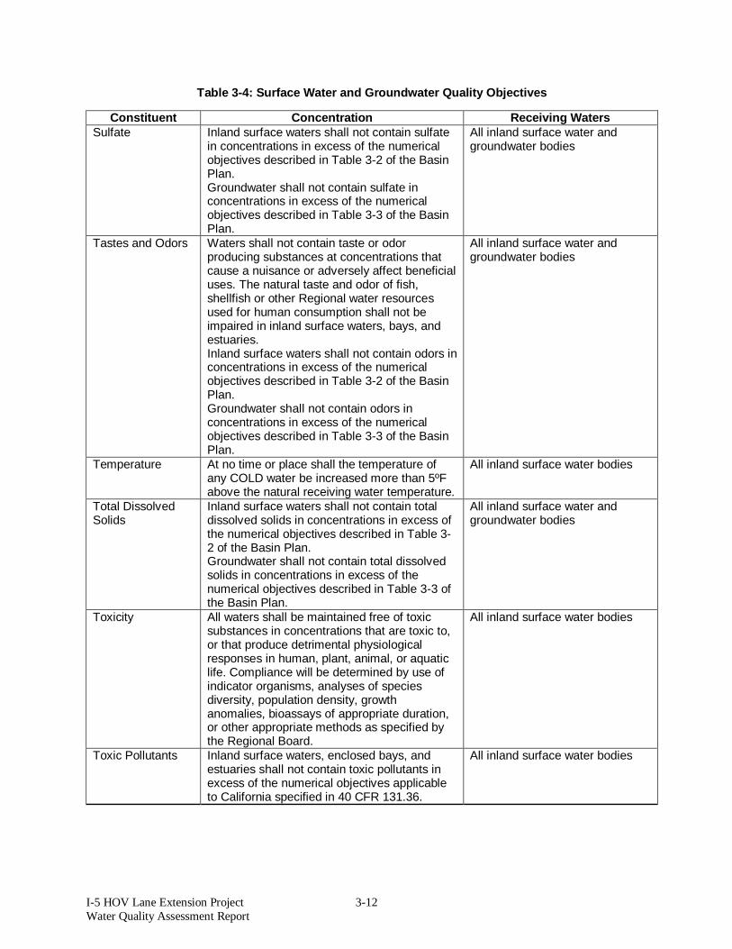
I-5 HOV Lane Extension Project 3-12 Water Quality Assessment Report
Table 3-4: Surface Water and Groundwater Quality Objectives
Constituent Concentration Receiving Waters Sulfate Inland surface waters shall not contain sulfate
in concentrations in excess of the numerical objectives described in Table 3-2 of the Basin Plan. Groundwater shall not contain sulfate in concentrations in excess of the numerical objectives described in Table 3-3 of the Basin Plan.
All inland surface water and groundwater bodies
Tastes and Odors Waters shall not contain taste or odor producing substances at concentrations that cause a nuisance or adversely affect beneficial uses. The natural taste and odor of fish, shellfish or other Regional water resources used for human consumption shall not be impaired in inland surface waters, bays, and estuaries. Inland surface waters shall not contain odors in concentrations in excess of the numerical objectives described in Table 3-2 of the Basin Plan. Groundwater shall not contain odors in concentrations in excess of the numerical objectives described in Table 3-3 of the Basin Plan.
All inland surface water and groundwater bodies
Temperature At no time or place shall the temperature of any COLD water be increased more than 5ºF above the natural receiving water temperature.
All inland surface water bodies
Total Dissolved Solids
Inland surface waters shall not contain total dissolved solids in concentrations in excess of the numerical objectives described in Table 3-2 of the Basin Plan. Groundwater shall not contain total dissolved solids in concentrations in excess of the numerical objectives described in Table 3-3 of the Basin Plan.
All inland surface water and groundwater bodies
Toxicity All waters shall be maintained free of toxic substances in concentrations that are toxic to, or that produce detrimental physiological responses in human, plant, animal, or aquatic life. Compliance will be determined by use of indicator organisms, analyses of species diversity, population density, growth anomalies, bioassays of appropriate duration, or other appropriate methods as specified by the Regional Board.
All inland surface water bodies
Toxic Pollutants Inland surface waters, enclosed bays, and estuaries shall not contain toxic pollutants in excess of the numerical objectives applicable to California specified in 40 CFR 131.36.
All inland surface water bodies

I-5 HOV Lane Extension Project 3-13 Water Quality Assessment Report
Table 3-4: Surface Water and Groundwater Quality Objectives
Constituent Concentration Receiving Waters Turbidity Waters shall be free of changes in turbidity that
cause nuisance or adversely affect beneficial uses. Inland surface waters shall not contain turbidity in excess of the numerical objectives described in Table 3-2 of the Basin Plan. Groundwater shall not contain total dissolved solids in concentrations in excess of the numerical objectives described in Table 3-3 of the Basin Plan.
All inland surface water and groundwater bodies
Source: San Diego RWQCB Basin Plan (April 2007) ºF = degrees Fahrenheit MUN = Municipal Water Supply AGR = Agricultural Supply N = Nitrogen CFR = Code of Federal Regulations NH3 = Ammonia COLD = Cold Freshwater Habitat NO3 = nitrate MBAS = Methylene blue-activated substances pH = Hydrogen Ion Concentration mg/L = milligrams per Liter REC-1 = Contact Recreation mL = milliliters WARM = Warm Freshwater Habitat
3.7 List of 303(d) Impaired Waters San Juan Creek, Prima Deshecha Cañada, and Segunda Deshecha Cañada are listed on the 2006 CWA Section 303(d) List of Water Quality Limited Segments. The list was approved by the SWRCB in October 2006 and approved by the EPA on June 28, 2007. The mouth of San Juan Creek, the Pacific Ocean shoreline near the mouth of San Juan Creek, and San Juan Creek are listed for Indicator Bacteria. San Juan Creek is also listed for dichlorodiphenyldichloroethylene (DDE). Prima Deshecha Cañada and Segunda Deshecha Cañada are both listed for Phosphorus and Turbidity. No TMDLs have been developed for the water bodies to which the project drains. Cascadita Creek is not impaired nor has a TMDL been developed. The project is not expected to be a major source of the pollutants for which the water bodies the project drains to are impaired. BMPs will be selected to control turbidity per Caltrans’ NPDES permit and SWMP requirements.

I-5 HOV Lane Extension Project 4-1 Water Quality Assessment Report
4 ENVIRONMENTAL CONSEQUENCES This chapter discusses the potential environment effects related to water quality with implementation of the project, as well as procedures and practices that will be applied to reduce those effects.
4.1 Potential Impacts to Water Quality
4.1.1 Short-Term Impacts during Construction
4.1.1.1 Alternative 1 (No Build Alternative) Under Alternative 1, no improvements other than routine roadway and bridge maintenance would be made. Therefore, Alternative 1 would result in no short-term water quality impacts from construction-related activities.
4.1.1.2 Alternatives 2, 3, and 4 (Build Alternatives) During construction, the estimated total disturbed area from the proposed project is summarized in Table 4-1.
Table 4-1: Estimated Disturbed Soil Area for Build Alternatives
Alternative Number Estimated Disturbed Soil Area Alternative 2 Option A = 132.3 acres
Option B = 134.4 acres Alternative 3 Option A = 126.6 acres
Option B = 128.6 acres Alternative 4 Option A = 126.1 acres
Option B = 128.1 acres
This is based on the total disturbed area, which includes additional elements, but is not limited to the following:
Retaining walls Auxiliary lanes Ramps Sound walls Drainage structures Proposed permanent water quality BMPs
Pollutants of concern that could be generated during construction include the following: Sediments (grading operations) Trash (construction workers and construction waste) Petroleum products (equipment) Concrete waste (dry and wet) Sanitary waste (portable toilets) Chemicals (equipment coolant and concrete curing compounds)

I-5 HOV Lane Extension Project 4-2 Water Quality Assessment Report
To comply with the General Construction Permit as stated in Measure WQ-1, the project would be required to:
Submit PRDs, including submitting an electronic NOI; Prepare a SWPPP; Enroll the project for coverage under the Construction General Permit at least 14 days
prior to the start of construction; Implement minimum erosion and sediment control BMPs; Conduct routine inspections; Conduct as-needed effluent and receiving water monitoring commensurate with its
sediment Risk Level; Submit an annual report to the SWRCB; and, Submit an electronic NOT.
If construction BMPs are properly designed, implemented, and maintained, as presented in Measures WQ-1 and WQ-2, no adverse water quality impacts would occur during construction of the proposed project. Groundwater dewatering may be necessary to construct the bridge structure footings and culvert extensions. Dewatered groundwater may contain high levels of TDS, salinity, high nitrates, or other contaminants, which could be introduced to surface waters during construction. Groundwater and any other non-stormwater dewatering activities are subject to the requirements of the De Minimus Permit (Order Number R9-2008-0002, NPDES Number CAG919002) or subsequent permit. Compliance with this permit, as stipulated in Avoidance, Minimization and/or Mitigation Measure WQ-3, would avoid adverse impacts to water quality via dewatering. The dewatering may require the use of BMPs such as siltation discharge bags or baker tanks, to remove potential pollutants that may be in the dewatering effluent.
4.1.2 Long-Term Impacts during Operation
4.1.2.1 Alternative 1 (No Build Alternative) Under Alternative 1, there would not be an increase in impervious area or change in land use on the I-5. Therefore, Alternative 1 would not result in an increase in long-term pollutant loading; however, existing runoff would remain untreated.
4.1.2.2 Alternatives 2, 3, and 4 (Build Alternatives) Pollutants of concern typically generated during the operation of a transportation facility include sediment/turbidity, nutrients, organic compounds, trash and debris, oxygen-demanding substances, bacteria and viruses, oil and grease, pesticides, and metals, as discussed in Section 2.9 of this report. Because the project consists of lane additions, it would result in a permanent increase of impervious surfaces and a permanent increase in runoff and pollutant loading. Alternatives 2, 3, and 4 will result in the estimated new impervious area summarized in Table 4-2.

I-5 HOV Lane Extension Project 4-3 Water Quality Assessment Report
Table 4-2: Estimated New Impervious Area for Build Alternatives
Alternative Number Estimated New Impervious Area Alternative 2 Option A = 19.0 acres
Option B = 19.9 acres Alternative 3 Option A = 18.3 acres
Option B = 19.3 acres Alternative 4 Option A = 16.5 acres
Option B = 17.3 acres
The increase in impervious area caused by the project is relatively small (much less than 1%) compared to the urbanized area within the entire San Juan Creek and San Clemente Coastal Streams watersheds.
The creeks downstream of the project are engineered master planned facilities, the minor increase in runoff volume is not expected to result in channel erosion, and hydromodification is not expected within the San Juan Creek or San Clemente Coastal Streams watersheds. Operation of the project is subject to the requirements of Caltrans’ NPDES Permit. As part of these requirements, Caltrans must
Consider approved Design Pollution Prevention (DPP) and Treatment Control BMPs for the project site; and
Construct DPPs and Treatment BMPs where feasible. Currently, stormwater runoff from I-5 within the project limits is untreated. As part of the proposed project, treatment BMPs must be implemented to target the constituents of concern in the stormwater runoff from the project area. The project will include BMPs that provide treatment for pollutants of concern per Caltrans guidelines.
Where feasible, DPPs and treatment control BMPs will be incorporated into the project design. The treatment control BMPs will be implemented to the maximum extent practicable. All treatment control BMPs will be located outside of CDFG and Corps jurisdictional waters. The siting and selection of treatment BMPs will be decided consistent with Caltrans’ Stormwater Quality Project Planning and Design Guide and documented in the project’s SWDR. BMPs selected will be based on the targeted constituents and they may include any of the following: vegetated strips/swales, detention devices, infiltration devices, media filters, and/or other Caltrans-approved treatment BMPs. The approved devices have been scientifically tested by Caltrans to ensure expected pollutant loads from the proposed project will be reduced by implementation of DPPs and treatment control BMPs.
Through complying with Caltrans’ Statewide NPDES permit and the Statewide SWMP (Measure WQ-1), the implementation of Measures WQ-4 (see Section 5) and WQ-5 to the MEP, designing and operating the project’s facility will result in no adverse impacts to water quality.

I-5 HOV Lane Extension Project 5-1 Water Quality Assessment Report
5 AVOIDANCE, MINIMIZATION, AND/OR MITIGATION MEASURES Caltrans’ SWMP is the guidance for compliance with the NPDES Permit requirement for discharge. As part of Caltrans’ Project Delivery Stormwater Management Program described in the SWMP, selected construction site, design pollution prevention, and treatment control BMPs would be incorporated into the final design of the proposed project. Compliance with the standard requirements of the SWMP for potential short-term (during construction) and long-term (post-construction/maintenance) impacts (listed below in Measures WQ-1, WQ-2, WQ-3, WQ-4, and WQ-5) is required.
WQ-1 The project will comply with the provisions of the Caltrans Statewide NPDES Permit (Order Number 99-06 DWQ, NPDES Number CAS00003) and the NPDES General Permit, Waste Discharge Requirements (WDRs) for Discharges of Storm Water Runoff Associated with Construction Activities (Order Number 2009-0009-DWQ, NPDES Number CAS000002) and any subsequent permit in effect at the time of construction.
WQ-2 A Stormwater Pollution Prevention Plan (SWPPP) shall be prepared and implemented to address all construction-related activities, equipment, and materials that have the potential to impact water quality. The SWPPP shall identify the sources of pollutants that may affect the quality of stormwater and include the construction site BMPs to control pollutants such as sediment control, catch basin inlet protection, construction materials management and non-stormwater BMPs. All construction site BMPs shall follow the latest edition of the Storm Water Quality Handbooks: Construction Site Best Management Practices (BMPs) Manual (Caltrans, 2003) to control and minimize the impacts of construction related activities, material and pollutants on the watershed. These include, but are not limited to temporary sediment control, temporary soil stabilization, scheduling, waste management, materials handling, and other non-stormwater BMPs. WQ-3 Construction site dewatering must comply with the General Waste Discharge Requirements for Discharges from Groundwater Extraction and Similar Discharges to Surface Waters Within the San Diego Region Except for San Diego Bay (Order Number R9-2008-0002 National Pollutant Discharge Elimination System (NPDES) Number CAG919002), and any subsequent updates to the permit at the time of construction. Dewatering BMPs must be used to control sediment and pollutants, and the discharges must comply with the Waste Discharge Requirements (WDRs) issued by the San Diego RWQCB. This will include submission of a Notice of Intent (NOI) to the San Diego Regional Water Quality Control Board (RWQCB) at least three months before the start of dewatering and compliance with all applicable provisions in the de minimus permit, including water sampling, analysis, and reporting of dewatering-related discharges. WQ-4 Caltrans approved treatment Best Management Practices (BMPs) will be implemented to the Maximum Extent Practicable (MEP) consistent with the requirements of the National Pollutant Discharge Elimination System (NPDES) Permit, Statewide Stormwater Permit, and Waste Discharge Requirements (WDRs) for the State of California, Department of Transportation (Caltrans) Properties, Facilities, and Activities (Order Number 99-06-DWQ, NPDES Number CAS000003) and any subsequent permits. Treatment BMPs may include biofiltration strips/swales, infiltration basins, detention

I-5 HOV Lane Extension Project 5-2 Water Quality Assessment Report
devices, dry weather flow diversion, Gross Solids Removal Devices (GSRDs), media filters, and wet basins.
WQ-5 Design Pollution Prevention Best Management Practices (BMPs) shall be implemented such as preservation of existing vegetation, slope/surface protection systems (permanent soil stabilization), concentrated flow conveyance systems such as ditches, berms, dikes and swales, overside drains, flared end sections, and outlet protection/velocity dissipation devices.

I-5 HOV Lane Extension Project 6-1 Water Quality Assessment Report
6 REFERENCES California Coastal Conservancy, Southern California Coastal Watershed Inventory, San Juan
Hydrologic Unit Profile, accessed via http://wrpinfo.scc.ca.gov/watersheds/briefs/sanjuan/index.html on November 18, 2009. The website was last updated August 21, 2001.
California Department of Fish and Game, in cooperation with the California State Water Resources Control Board and the California Department of Water Resources, Hydrologic Watersheds Geographic Information Systems Data, November 1, 1995, accessed via the California Department of Transportation’s Transportation Systems Information Division’s website: http://www.dot.ca.gov/hq/tsip/gis/datalibrary/gisdatalibrary.html
California Department of Transportation, BMP Retrofit Pilot Program - Final Report, January 2004 (CTSW-RT-01-050)
———. Discharge Characterization Study Report, November 2003 (CTSW-RT-03-065.51.42) ———. Project Study Report – 12-ORA-005, PM 3.30/8.70, 12840-0F960K, February 2009.
———. Statewide Stormwater Management Plan, May 2003 (CTSW-RT-02-008). ———. Stormwater Quality Handbooks, Project Planning and Design Guide, May 2007.
(CTSW-RT-07-172.19.1) California Department of Water Resources, California’s Groundwater, Bulletin 118, updated
October 2003, http://www.water.ca.gov/pubs/groundwater/bulletin_118/basindescriptions/6-44.pdf, accessed February, 2010.
California Regional Water Quality Control Board, San Diego Region, Water Quality Control Plan for the San Diego Basin (9), September 8, 1994 (with amendments effective prior to April 25, 2007).
County of Orange Stormwater Program, Unified Annual Progress Report Program Effectiveness Assessment, Santa Ana Region and San Diego Region, 2007-2008 Reporting Period, November 14, 2008.
Federal Emergency Management Agency (FEMA) Map Service Center, Flood Maps. http://msc.fema.gov, accessed November 2009.
State Water Resources Control Board (SWRCB), National Pollutant Discharge Elimination System (NPDES) Permit, Statewide Stormwater Permit and Waste Discharge Requirements (WDRs) for the State of California, Department of Transportation Properties, Facilities, and Activities (Order Number 99-06-DWQ, NPDES Number CAS000003), July 1999.
———. National Pollutant Discharge Elimination System (NPDES) General Permit for Storm Water Discharges Associated with Construction and Land Disturbance Activities (Order Number 2009-0009-DWQ, NPDES Number CAS000002), September 2, 2009.
United States Army Corps of Engineers, Los Angeles District, San Juan Creek Watershed Management Study, Orange County, California, Feasibility Phase F-5 Report, August 2002.

I-5 HOV Lane Extension Project 6-2 Water Quality Assessment Report
United States Department of Agriculture, Natural Resources Conservation Service, Web Soil Survey data, accessed via their website: http://websoilsurvey.nrcs.usda.gov/app