tables - department of natural resources · table 6.–national pollution discharge elimination...
TRANSCRIPT

Black River Assessment
TABLES
141

Black River Assessment
142
This page was intentionally left blank.
Black River Assessment
143
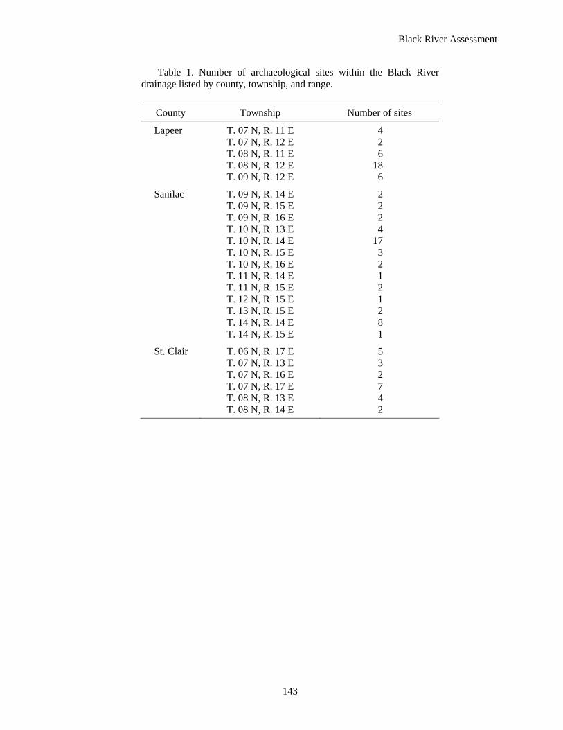
Table 1.–Number of archaeological sites within the Black River drainage listed by county, township, and range.
County Township Number of sites
Lapeer T. 07 N, R. 11 E 4 T. 07 N, R. 12 E 2 T. 08 N, R. 11 E 6 T. 08 N, R. 12 E 18 T. 09 N, R. 12 E 6
Sanilac T. 09 N, R. 14 E 2 T. 09 N, R. 15 E 2 T. 09 N, R. 16 E 2 T. 10 N, R. 13 E 4 T. 10 N, R. 14 E 17 T. 10 N, R. 15 E 3 T. 10 N, R. 16 E 2 T. 11 N, R. 14 E 1 T. 11 N, R. 15 E 2 T. 12 N, R. 15 E 1 T. 13 N, R. 15 E 2 T. 14 N, R. 14 E 8 T. 14 N, R. 15 E 1
St. Clair T. 06 N, R. 17 E 5 T. 07 N, R. 13 E 3 T. 07 N, R. 16 E 2 T. 07 N, R. 17 E 7 T. 08 N, R. 13 E 4 T. 08 N, R. 14 E 2

Black River Assessment
144
Table 2.–Mean annual discharge, drainage area, and yield at six United States Geological Survey gauge sites in the Black River watershed. Discharge units are cubic feet per second (cfs).
Gauge site Gauge number
Period of record
Drainage area (mi2)
Mean annual discharge (cfs)
Yield (cfs/mi2)
Mean daily flow in August (cfs)
Silver Creek near Jeddo 4159488 1978–82 21 14.5 0.69 3.2 Black River near Jeddo 4159492 1944–06 464 301.5 0.65 63.2 Black River near Fargo 4159500 1944–91 480 262.8 0.55 58.5 Mill Creek near Avoca 4159900 1963–06 169 96.7 0.57 16.5 Mill Creek near Abbottsford 4160000 1947–64 208 96.9 0.47 18.8 Black River near Port Huron 4160050 1932–43 684 284.9 0.42 3.2
Table 3.–Period of record maximum and minimum daily discharges (year of occurrence in parentheses) at United States Geological Survey gauging stations on the Black River. Data from United States Geological Survey. Discharge units are cubic feet per second (cfs).
Gauge Largest Smallest Largest Smallest Full years of Gauge site number Maximum flow (cfs) Minimum flow (cfs) data in record
Silver Creek near Jeddo 4159488 701 (1981) 348 (1979) 0.7 (1979) 0.1 (1978) 4 Black River near Jeddo 4159492 10,100 (1947) 387 (1964) 36.0 (1997) 2.0 (1948) 63 Black River near Fargo 4159500 10,100 (1947) 387 (1964) 13.0 (1952) 2.0 (1948) 22 Mill Creek near Avoca 4159900 3,940 (1975) 64 (1964) 13.0 (1992) 0.9 (1964) 31 Mill Creek near Abbottsford 4160000 2,870 (1962) 350 (1958) 8.3 (1953) 2.9 (1963) 16 Black River near Port Huron 4160050 10,600 (1942) 2,250 (1941) 17.0 (1943) 4.6 (1941) 11

Black River Assessment
145
Table 4.–Cover type in the Black River watershed in acres. Presettlement data were taken from Michigan Department of Natural Resources, Michigan Resource Inventory System (MIRIS). Land cover in 1992 was determined from the United States Geological Survey (USGS) National Land Cover Data (NLCD).
Cover type Presettlement
(c. 1800) Current
1992 Percent change
1800–1992
Commercial 0 1,625 +100 Cultivated 0 358,642 +100 Emergent herbaceous wetland 10,370 692 -87 Forested 442,885 84,694 -68 Open water 1,342 2,085 +22 Gravel pit 0 176 +100 Residential 0 6,546 +100 Transitional 0 130 +100
Table 5.–Dams in the Black River watershed, sorted by county. Date is the year of construction; location is provided by township (T.), range (R.), and section (Sec.); Owner indicates ownership as private, state, or local government; question marks indicate data are missing. Data from L. Szabo Kraft (Michigan Department of Natural Resources Spatial Information Resource Center).
Dam name Water body Date T. R. Sec. OwnerHead (ft)
Pond area (acres)
Storage (acre-ft)
Sanilac Croswell Dam Black River 1902 10N 16E 29 Private 8 42 300 Donovan Dam Unnamed tributary ? 09N 16E 5 Private ? 3 ?
Lapeer N. Br. Mill Creek Dam N. Br. Mill Creek 1965 08N 12E 29 Local 18 250 2,965 Baggerly Dam Madison Drain ? 09N 12E 33 Private ? 4 ?
St. Clair Ford’s (Wingford) Dam Black River 1930 07N 16E 8 Private 17 93 3,000 Port Huron SGA No. 4 Walker Flats flooding 1966 07N 16E 16 State 7 45 180 Yale Woolen Mill Dam Mill Creek ? 08N 14E 10 Local 1 20 ? Cade Road Dam South Branch Drain ? 07N 13E 6 Private 3 1 ?

Black River Assessment
146
Table 6.–National Pollution Discharge Elimination System permits issued in the Black River watershed. Data from Michigan Department of Environmental Quality, Surface Water Quality Division.
Valley segment or subwatershed ID
City Receiving water Designated name Permit type number
Segment 1 Carsonville Black River Waste Management of Michigan,
Incorporated Industrial storm water 45
Waste Management of Michigan,
Incorporated Industrial storm water 46 Deckerville Grandy Drain Plastacoat, Incorporated Industrial storm water 33 Trim Trends Company LLC Individual 44 Minden City Black River Bay Houston Towing Company,
Incorporated Industrial storm water 2 Carsonville Black River Black River Hardwoods General seasonal 5 Deckerville Pelton Drain Deckerville WWSL Industrial storm water 16 Flannigan Drain Midwest Rubber Company Industrial storm water 28
Segment 2 Croswell Black River Conveyor Components Company Industrial storm water 12
Cotterman Company General seasonal 13 Unnamed Country Hill Pines MHP Individual 14 Black River City of Croswell Industrial storm water 15
Jay & Kay Manufacturing
Incorporated Individual 21 Michigan Sugar Company Industrial storm water 25
Unnamed tributary
to Black River Paramount Industries Incorporated Industrial storm water 31
Theut Concrete Products,
Incorporated General seasonal 42 Carsonville Unnamed Carsonville WWSL Industrial storm water 10
Carsonville Drain Randy's Auto Salvage Industrial storm water 37
Segment 3 Jeddo Black River Mid-Michigan Materials
Incorporated General seasonal 26 Brown City Elk Creek Brown City WWSL General seasonal 8
Segment 4 Fort Gratiot Unnamed Port Huron Area Schools Industrial storm water 36 Kimball Black River Black River Concrete General seasonal 4 Port Huron Black River Port Huron Area School District Industrial storm water 35
Acheson Colloids Company Industrial storm water 1 Desmond Marine, LLC Industrial storm water 18 Mueller Brass Company General seasonal 29

Black River Assessment
147
Table 6.–Continued.
Valley segment or subwatershed ID
City Receiving water Designated name Permit type number
Berry Drain Sandusky Stoney Creek Drain Jensen Bridge & Supply Company General seasonal 22
Unnamed Sunset Mobile Home Park WWSL Individual 41 Trelleborg YSH, Incorporated Individual 43
Potts Drain Bay Houston Towing Company,
Incorporated Industrial storm water 3 Berry Drain Fred J. Breiten Lumber Company Industrial storm water 20 Numatics, Incorporated Industrial storm water 30
Black Drain Sandusky Concrete & Supply
Incorporated Individual 39 Unnamed City of Sandusky Industrial storm water 40
Elk Creek Croswell Unnamed Buel Hill MHP WWSL General seasonal 9 Brown City Unnamed Brown City Camp General seasonal 6 Peck Unnamed Peck WWSL General seasonal 32 Brown City Unnamed Brown City Water Treatment Plant Industrial storm water 7
Lapeer Sanilac
Drain Frank Industries, Incorporated Industrial storm water 19 Link Technologies Industrial storm water 24
Black Creek Yale Mill Creek Redall Industries Incorporated General seasonal 38
Unnamed Parkview Property Management
Incorporated General seasonal 48 Mill Creek City of Yale General seasonal 50
Silver Creek Avoca Unnamed Detroit Edison Company Industrial storm water 17
Plum Creek Avoca Unnamed Plum Creek Estates, LLC Individual 34
Mill Creek 23 Attica Unnamed Lapeer County Education and
Technology Center General seasonal 47 Yale Mill Creek Yale Industries Industrial storm water 49 Yale Steel Incorporated Groundwater 11 Imlay City Unnamed Champion Bus Incorporated General seasonal 51 Avoca Mills Creek City of Yale Individual 27 Capac Unnamed Mid-Michigan Gas Storage
Company Groundwater 23

Black River Assessment
148
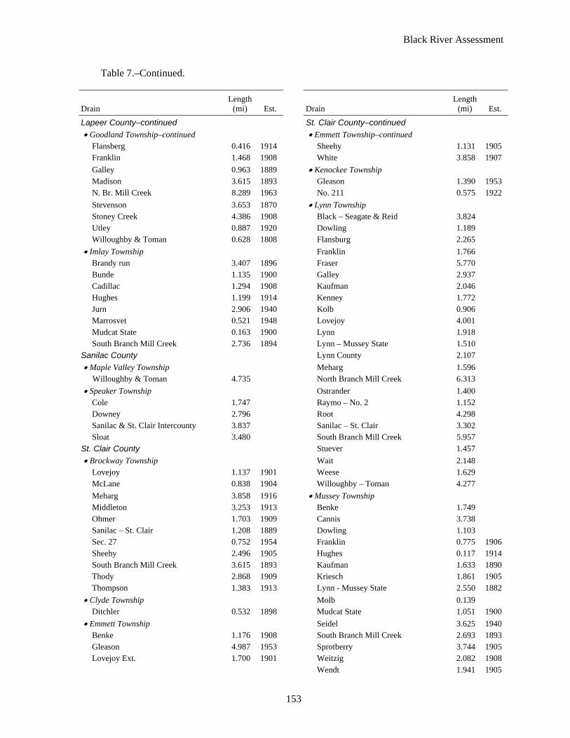
Table 7.–Designated drain names, length (mi), and establishment date (Est.) in the Black River watershed by valley segment. Information provided by each county drain office.
Drain Length
(mi) Est. Drain Length
(mi) Est.
Main Stem Valley Segment 1 Sanilac County Sanilac County–continued • Bridgehampton Township • Minden Township–continued
Black River 4.469 Darlington 3.606 1903 Dwight 1.364 1969 Duggan 0.947 Leonard 0.999 1913 McManus 1.080 1914 Lux 0.394 Swercz Relief 1.151 1914 McDonald 4.293 1888 • Washington Township Pyette 1.571 1893 Gordon 2.516 1887 Shrapnel 3.454 1910 McDonald 0.886 1888 Southworth 1.114 • Watertown Township Unknown McDonald connecter 1.237 Gordon 0.950 1990
• Custer Township • Wheatland Township Anderson 1.121 1904 Bishop 5.408 1895 Black River 3.355 1957 Black River 6.821 1957 Custer Twp Hwy 1.534 1901 Burget 1.414 1906 Dwight 1.082 1894 Carroll Cut-Off 2.184 1914 Freel 1.005 Churchill 0.249 1887 Kirkpatrick 0.900 1910 Flannigan 0.940 1907 Laughren 1.189 1938 Hewitt 2.270 1894 Nichol 5.670 1904 McMannus 3.335 1914 O’Connell 0.833 1916 Merriman 0.858 1907 Pyette 0.717 1893 Paige 1.413 1906 Wilkins 5.022 Pelton 2.715 1885
• Marion Township Ritchie 5.544 1911 Deckerville 0.202 Sherwood 0.415 1902 Flannigan 0.115 1907 Smith 2.582 1911 Grandy 3.957 1895 Terpenning 0.561 1907 Pelton 1.078 1885 Theyer 2.180 1912
• Minden Township Thompson 1.976 1893 Bishop 1.407 1895 Black River & Swercz 7.182 1957
Berry Drain Subwatershed Sanilac County Sanilac County–continued • Bridgehampton Township • Custer Township–continued
Berry 0.651 1910 Kenny 6.493 1890 Fry 0.630 1892 Rich 1.517
• Custer Township Stone 2.283 1910 Badgero 1.921 1896 • Watertown Township Baerwolf 4.684 1913 Berry 1.926 1910 Berry 5.091 1910 Black 2.185 1912 Custer County 5.945 1901 Gauge 1.458 1911 Dwight 9.140 1894 Howse 1.409 1912 Fye 4.106 1892 Sandusky 1.452 1905 Graves 2.176 1914 Stone 1.130 1901 House 0.101 1912

Black River Assessment
149
Table 7.–Continued.
Drain Length
(mi) Est. Drain Length
(mi) Est.
Main Stem Valley Segment 2 Sanilac County Sanilac County–continued • Bridgehampton Township • Lexington Township–continued
Kelley 0.663 Herk 0.791 • Buel Township Jenny 1.069
Arnot 5.004 Johnston 2.154 May 0.830 Kott 0.613 Mclelland 5.597 Mclelland 1.900 Mills 6.063 Mills 2.249 P. O. E. Perry 0.696 No. 2 County Road 0.483 Pabst 2.306 No. 3 County Road 0.453 Smyth 1.955 Rosenstil 0.858 Taylor 4.211 Wagner 0.346 Vincent 0.557 1883 • Worth Township Wagner 1.915 1889 Achenson 0.529 Watson 2.161 • Washington Township
• Lexington Township Black River Intercounty 9.593 Black River 1.942 Carsonville 1.966 1923 Chenson 0.476 Kelly 3.228 Croswell 1.578 Murray 2.917 Freeman 2.348 Pabst 5.065 1895
Elk Creek Subwatershed Lapeer County Sanilac County–continued • Burnside Township • Elk Township–continued
Ellis "Relief" 0.379 1898 Cowley 0.997 1907 Lapeer & Sanilac 2.675 1908 Elk & Buel 0.404 1889 Setter 4.247 1899 Elk Creek 7.228 1899
Sanilac County Elk, Flynn & Maple Valley 1.841 1889 • Buel Township Elk-Speaker 1.578 1909
Baum 1.472 1889 Elsholz 0.688 1916 County Rd. drain No. 1 0.658 1929 Engle 1.178 1913 Engle 1.146 1913 Fletcher 0.698 1894 French 7.089 1892 Jones 1.058 1896 Hunt 1.133 1897 Maedel 0.233 1913 Maedel 0.501 1913 McCauley 1.434 1907 Miller 3.270 1938 McDonald 3.207 1894 Oak & Buel 1.037 McElhenney 6.637 1890 Potts 8.333 1894 Mullen 1.624 1902 Rickett 2.524 1889 Omard 1.034 1906 Roskey 5.744 1897 Parks 1.286 1894 Siefert 0.552 1892 Phillips 1.776 1924 Thomas 0.534 1899 Potts 4.583 1894 Topping 4.387 1894 Powers 2.673 1906 Wannamaker 0.539 1910 Rickett 1.594 1889
• Elk Township Rowe 2.204 Barr 1.258 1897 Ryland 2.877 1892 Bowers 1.101 1913 Shell 0.888

Black River Assessment
150
Table 7.–Continued.
Drain Length
(mi) Est. Drain Length
(mi) Est.
Sanilac County–continued Sanilac County–continued • Elk Township–continued • Maple Valley Township–continued
Siefert 1.003 1892 Payne 0.554 Smafield 1.468 1913 Scott 1.621 1926 Speaker & Maple Valley 3.803 Setter 3.534 1894 Spring Creek 2.360 1889 Shoemaker 2.390 1908 Squires 1.307 1912 Speaker & Maple Valley 2.881 Tenniswood 2.141 Valley Center 2.738 1912 Thomas 1.736 1899 Varney 3.477 1909
• Elmer Township Willoughby & Toman 0.083 Beals & Frizzle 4.113 1883 Windsor 0.660 1912 Cummer 2.787 1894 Winters 4.701 1889 Hale 3.788 1883 Witmer 3.456 1903 McElhinney 0.367 1890 York 2.430 1910 Severance 0.217 1889 • Speaker Township
• Flynn Township Beemer 2.553 1907 Brown 0.936 1954 Cline 2.915 1908 Campbell 0.615 Cork 4.418 1911 Eagle 2.495 1918 Elk-Speaker (Donnelly 1892) 3.097 1909 Elk Creek 1.618 1909 Fletcher 3.332 1894 Elk, Flynn & Maple Valley 4.984 1889 Kern 1.067 Hector 0.425 1893 Lord 0.981 Jones 2.597 1896 Macklem 1.584 1906 Large 2.968 1905 Melvin 1.826 1951 McElhinney 0.324 1890 Mullaney 3.315 1907 Omard 2.165 1906 Potts 4.265 1894 Phillips 0.396 1924 Putney 2.703 1953 Rumble 0.786 1893 Shell 0.787 Setter 17.677 1894 Solan 2.084 1910 Simson 1.059 Speaker & Maple Valley 3.994 1905 Stimson 0.791 1889 Spring Creek 3.311 1991 Tuer 0.991 Utter Branch 1.189 Welch 4.020 1909 Weston 0.990
• Fremont Township • Washington Township Hunt 1.777 1897 Alexander 1893 Lord 3.962 1898 Crow
• Maple Valley Township Elk Creek 1899 Brown 0.324 Hayes 0.503 1906 Brown City 0.685 McPherson 2.770 1889 Elk Creek 7.448 1899 Methven 2.430 Elk, Flynn & Maple Valley 1.115 1889 Meyers (Myers) 1.670 Hydorn 3.508 1909 Potts 0.752 1894 Laidlaw 1.314 1899 Recor 1.944 1890 Langdon 4.425 1902 Rickett 0.483 1889 Lapeer & Sanilac 5.799 1889 Roskey 0.135 1897 Macklem 3.951 1906 Washington 0.704 1912 McElroy 1.121 1906

Black River Assessment
151
Table 7.–Continued.
Drain Length
(mi) Est. Drain Length
(mi) Est.
Elk Creek Subwatershed Sanilac County–continued Sanilac County–continued • Watertown Township • Watertown Township–continued
Adams 0.979 1891 McElhinney 0.890 1890 Beals & Frizzle 7.710 1883 McPherson 1.782 1889 Cloclough 1.684 Methven 0.873 Cummer 0.492 1894 Mullen 1.382 1902 Eggert 5.370 1904 Murphy 1.830 1895 Elholz 1.220 1916 Parkinson 1.670 1888 Elk Creek 5.071 1899 Parks 1.455 1894 Hale 2.550 1883 Ricket 0.862 1889 Harneck 0.992 1915 Severance 3.190 1889 Hayes 0.298 1906 Smalldon 4.306 1899 Johnson-Barrett 1.804 1915 Walker 1.189 1888 Maitland 0.326 Watertown State 3.753 1904
Main Stem Valley Segment 3 Sanilac County Sanilac County–continued • Fremont Township • Worth Township–continued
Barnes 0.170 VanSickle 0.111 Rattray 0.580 St. Clair County
• Worth Township • Clyde Township Barnes 0.366 Glyshaw 1.458 1915 Coats 1.647 Kingsley 0.536 1964 Mason 1.601 No. 208 0.399 1920 Rattray 0.320 O’Dette 0.763 1912
Black Creek Subwatershed St. Clair County Sanilac County–continued • Brockway Township • Fremont Township–continued
Brennan 0.111 1914 Coon 1.474 Jackson Creek 2.655 1909 Crouce 1.686 Livergood & Ext. 2.330 1906 Jackson Creek 6.543 Teets 1.473 1914 Lawson 2.328
• Greenwood Township Livergood 0.284 Brennan 0.330 1914 Massacar (Bigger) 1.076 Jackson Creek 1.128 1909 McIntyre & Willing 3.476 Livergood & Ext. 3.972 1906 Nelson & Spencer 0.938 Robertson 2.694 1909 Perry 3.002 Teets 0.150 1914 Rector 0.783
Sanilac County Robertson 0.287 • Buel Township Seymore Creek 12.343
Br. #1 Seymore Ck. 1.734 Sheridan 1.529 • Fremont Township Turner 2.310
Allen 1.030 W. M. Doan 0.670 Black Creek 5.508 Willey 3.995 Bradley 0.788 • Speaker Township Burns 0.436 Black Creek 3.558 Conroy & Ferriby 1.289 Jackson Creek 0.497

Black River Assessment
152
Table 7.–Continued.
Drain Length
(mi) Est. Drain Length
(mi) Est.
Sanilac County–continued Sanilac County–continued • Speaker Township–continued • Worth Township
Lavell 0.069 William Doan 1.734 Rector 0.386
Silver Creek Subwatershed St. Clair County St. Clair County–continued • Brockway Township • Greenwood Township–continued
Eves 0.964 1906 Vincent 1.326 1907 • Greenwood Township Willey 0.325 1963
Black 1.979 1929 Wilson 0.125 1914 Bricker 1.238 1907 • Grant Township Butcher 0.435 1965 Fuselein 0.109 1945 Eves 13.949 1906 Neil 0.798 1914 Furlong 1.043 1908 Wilson 0.583 1914 Fuselein 3.615 1945 Sanilac County Gorman 1.489 1908 • Fremont Township Hayes 4.200 1908 Preston 0.415 Holley 2.928 1948 Willey 1.402 Jackson 4.114 1907 Wilson 1.932 Neil 1.732 1914
Plum Creek Subwatershed St. Clair County St. Clair County–continued • Grant Township • Greenwood Township–continued
King 0.070 Hill 1.592 1914 Youngs 0.817 Plum Creek 4.244
• Greenwood Township Pohly 2.315 Engles 1.743 1907 Todd 1.948
Mill Creek Subwatershed Lapeer County Lapeer County–continued • Arcadia Township • Attica Township–continued
Barber 0.368 1890 Fern 0.810 1908 Brant Lake 3.190 1904 Lumbar 2.899 1903 Devall 1.889 1903 Rogers & Swamp Corners 0.821 1892 Elgin 0.721 1925 • Burnside Township Lister 1.070 1917 Clarkson 0.243 1910 Mud Lake 2.734 1908 Evans & McKillan 1.687 1910 Rogers & Swamp Corners 2.943 1892 • Goodland Township Simmons Lake 0.603 1905 Anchor 1.069 1911 Soper 0.784 1913 Barnes 1.151 1941 Utley 0.070 1920 Black Segate & Reid 1.711 1899 Winn 1.475 1917 Clarkson 1.688 1910
• Attica Township Courter 2.030 1911 Barber 0.979 1890 Crow 2.584 1898 Booth 1.538 1905 East Goodland 2.702 1904 Cadillac 0.303 1908 Evans & McKillan 1.458 1910
Black River Assessment
153
Table 7.–Continued.
Drain Length
(mi) Est. Drain Length
(mi) Est.
Lapeer County–continued St. Clair County–continued • Goodland Township–continued • Emmett Township–continued
Flansberg 0.416 1914 Sheehy 1.131 1905 Franklin 1.468 1908 White 3.858 1907 Galley 0.963 1889 • Kenockee Township Madison 3.615 1893 Gleason 1.390 1953 N. Br. Mill Creek 8.289 1963 No. 211 0.575 1922 Stevenson 3.653 1870 • Lynn Township Stoney Creek 4.386 1908 Black – Seagate & Reid 3.824 Utley 0.887 1920 Dowling 1.189 Willoughby & Toman 0.628 1808 Flansburg 2.265
• Imlay Township Franklin 1.766 Brandy run 3.407 1896 Fraser 5.770 Bunde 1.135 1900 Galley 2.937 Cadillac 1.294 1908 Kaufman 2.046 Hughes 1.199 1914 Kenney 1.772 Jurn 2.906 1940 Kolb 0.906 Marrosvet 0.521 1948 Lovejoy 4.001 Mudcat State 0.163 1900 Lynn 1.918 South Branch Mill Creek 2.736 1894 Lynn – Mussey State 1.510
Sanilac County Lynn County 2.107 • Maple Valley Township Meharg 1.596
Willoughby & Toman 4.735 North Branch Mill Creek 6.313 • Speaker Township Ostrander 1.400
Cole 1.747 Raymo – No. 2 1.152 Downey 2.796 Root 4.298 Sanilac & St. Clair Intercounty 3.837 Sanilac – St. Clair 3.302 Sloat 3.480 South Branch Mill Creek 5.957
St. Clair County Stuever 1.457 • Brockway Township Wait 2.148
Lovejoy 1.137 1901 Weese 1.629 McLane 0.838 1904 Willoughby – Toman 4.277 Meharg 3.858 1916 • Mussey Township Middleton 3.253 1913 Benke 1.749 Ohmer 1.703 1909 Cannis 3.738 Sanilac – St. Clair 1.208 1889 Dowling 1.103 Sec. 27 0.752 1954 Franklin 0.775 1906 Sheehy 2.496 1905 Hughes 0.117 1914 South Branch Mill Creek 3.615 1893 Kaufman 1.633 1890 Thody 2.868 1909 Kriesch 1.861 1905 Thompson 1.383 1913 Lynn - Mussey State 2.550 1882
• Clyde Township Molb 0.139 Ditchler 0.532 1898 Mudcat State 1.051 1900
• Emmett Township Seidel 3.625 1940 Benke 1.176 1908 South Branch Mill Creek 2.693 1893 Gleason 4.987 1953 Sprotberry 3.744 1905 Lovejoy Ext. 1.700 1901 Weitzig 2.082 1908 Wendt 1.941 1905

Black River Assessment
154
Table 7.–Continued.
Drain Length
(mi) Est. Drain Length
(mi) Est.
Main Stem Valley Segment 4 St. Clair County St. Clair County – continued • Clyde Township • Fort Gratiot Township–continued
Brandymore 1.605 Routley 1.091 1914 • Fort Gratiot Township Stimson Storm Sewer 0.178 1966
Black River Canal 1.087 Warner 1.629 1917 Brandymore 3.641 • Port Huron Township Collins 1.127 1958 Baldwin 1.791 1868 Gossman 2.386 1927 Blackney 1.626 1919 Howe 2.400 1890 Hopps 1.045 1962 Moore 1.244 1931 Price 3.080 1893

Black River Assessment
155
Table 8.–List of fish species historically found in the Black River watershed. Origin: N=Native, C=Colonized, I=Introduced; Status: P=Considered present in 2008, U=Unknown. Species that are state-listed are labeled endangered (SE), threatened (ST), and special concern (SC).
Common name Scientific name Origin Status
Lampreys Petromyzontidae northern brook lamprey Ichthyomyzon fossor N P silver lamprey Ichthyomyzon unicuspis N P American brook lamprey Lampetra appendix N P sea lamprey Petromyzon marinus C P
Sturgeons Acipenseridae lake sturgeon (ST) Acipenser fulvescens N U
Gars Lepisosteidae longnose gar Lepisosteus osseus N P
Bowfins Amiidae bowfin Amia calva N P
Herrings Clupeidae alewife Alosa pseudoharengus C P gizzard shad Dorosoma cepedianum N P
Carps and minnows Cyprinidae central stoneroller Campostoma anomalum N P goldfish Carassius auratus I P spotfin shiner Cyprinella spiloptera N P common carp Cyprinus carpio I P brassy minnow Hybognathus hankinsoni N P striped shiner Luxilus chrysocephalus N P common shiner Luxilus cornutus N P redfin shiner Lythrurus umbratilis N P hornyhead chub Nocomis biguttatus N P river chub Nocomis micropogon N P golden shiner Notemigonus crysoleucas N P pugnose shiner (SE) Notropis anogenus N P emerald shiner Notropis atherinoides N P ghost shiner Notropis buchanani N P silverjaw minnow Notropis buccatus N P blackchin shiner Notropis heterodon N P blacknose shiner Notropis heterolepis N P spottail shiner Notropis hudsonius N P rosyface shiner Notropis rubellus N P sand shiner Notropis stramineus N P mimic shiner Notropis volucellus N P bluntnose minnow Pimephales notatus N P fathead minnow Pimephales promelas N P blacknose dace Rhinichthys obtusus N P creek chub Semotilus atromaculatus N P

Black River Assessment
156
Table 8.–Continued.
Common name Scientific name Origin Status
Suckers Catostomidae quillback Carpiodes cyprinus N P white sucker Catostomus commersonii N P lake chubsucker Erimyzon sucetta N P northern hog sucker Hypentelium nigricans N P black buffalo Ictiobus niger N P spotted sucker Minytrema melanops N P silver redhorse Moxostoma anisurum N P black redhorse Moxostoma duquesnei N P golden redhorse Moxostoma erythrurum N P shorthead redhorse Moxostoma macrolepidotum N P greater redhorse Moxostoma valenciennesi N P
Bullhead catfishes Ictaluridae black bullhead Ameiurus melas N P yellow bullhead Ameiurus natalis N P brown bullhead Ameiurus nebulosus N P channel catfish Ictalurus punctatus N P stonecat Noturus flavus N P tadpole madtom Noturus gyrinus N P
Pikes Esocidae grass pickerel Esox americanus N P northern pike Esox lucius N P
Mudminnows Umbridae central mudminnow Umbra limi N P
Trouts Salmonidae rainbow trout Oncorhynchus mykiss I P brown trout Salmo trutta I P
Trout-perches Percopsidae trout-perch Percopsis omiscomaycus N P
Silversides Atherinidae brook silverside Labidesthes sicculus N P
Sticklebacks Gasterosteidae brook stickleback Culaea inconstans N P
Sculpins Cottidae mottled sculpin Cottus bairdii I P
Striped basses Moronidae white perch Morone americana C P white bass Morone chrysops N P

Black River Assessment
157
Table 8.–Continued.
Common name Scientific name Origin Status
Sunfishes Centrarchidae rock bass Ambloplites rupestris N P green sunfish Lepomis cyanellus N P pumpkinseed Lepomis gibbosus N P bluegill Lepomis macrochirus N P northern longear sunfish Lepomis peltastes N P redear sunfish Lepomis microlophus I P smallmouth bass Micropterus dolomieu N P largemouth bass Micropterus salmoides N P white crappie Pomoxis annularis N P black crappie Pomoxis nigromaculatus N P
Perches Percidae eastern sand darter (ST) Ammocrypta pellucida N greenside darter Etheostoma blennioides N P rainbow darter Etheostoma caeruleum N P Iowa darter Etheostoma exile N P fantail darter Etheostoma flabellare N P least darter Etheostoma microperca N P johnny darter Etheostoma nigrum N P yellow perch Perca flavescens N P logperch Percina caprodes N P blackside darter Percina maculata N P walleye Sander vitreus N P
Drums Sciaenidae freshwater drum Aplodinotus grunniens N P
Gobies Gobiidae round goby Neogobius melanostomus I P

Black River Assessment
158
Table 9.–Types of fish surveys conducted by the Michigan Department of Natural Resources in the Black River watershed. Sites are individual locations on the river which were normally accessed at road crossings. Area sampled is an estimate of the total water surface surveyed by each gear type. Impoundment gear included trap and fyke nets (usually trap nets) which were used in reservoirs above dams and human-made ponds close to the Black River.
Gear type Number sites
surveyed Area sampled
(acres) Number years
Backpack shocker 13 4.3 4 Stream shocker 40 80.9 9 Boom shocker 6 43.5 4 Rotenone 11 12.5 1 Impoundment gear 8 20.9 7

Black River Assessment
159
Table 10.–Total catch of fish during all Michigan Department of Natural Resources fisheries surveys conducted in the Black River watershed during 1972–2006 ordered from most to least abundant. Species that are state-listed are labeled endangered (SE), threatened (ST), and special concern (SC).
Species Total caught Sample occurrences
mimic shiner 2,665 18 common shiner 2,334 40 bluntnose minnow 2,121 44 bluegill 1,860 36 white sucker 1,686 53 golden redhorse 1,669 36 creek chub 1,396 36 rock bass 1,333 61 johnny darter 1,325 46 greenside darter 1,025 24 blackside darter 934 49 common carp 875 49 sand shiner 856 11 pumpkinseed 826 42 stonecat 772 30 central stoneroller 743 18 spotfin shiner 714 27 northern hog sucker 713 34 green sunfish 626 31 rainbow darter 480 18 smallmouth bass 377 37 white crappie 321 14 gizzard shad 315 14 mudminnow 275 4 rosyface shiner 275 11 freshwater drum 270 10 blacknose shiner 260 8 black bullhead 241 27 channel catfish 241 20 golden shiner 223 12 logperch 210 11 yellow bullhead 207 21 largemouth bass 185 21 northern pike 164 38 central mudminnow 143 16 striped shiner 129 5 pugnose shiner (SE) 128 2 redear sunfish 124 1 emerald shiner 111 10 silver redhorse 109 18 brassy minnow 85 4 hornyhead chub 71 14 shorthead redhorse 69 8 quillback 63 8 redfin shiner 62 9

Black River Assessment
160
Table 10.–Continued.
Species Total caught Sample occurrences
yellow perch 61 19 greater redhorse 60 9 brown bullhead 45 6 black crappie 44 14 longear sunfish 44 8 Iowa darter 43 8 round goby 39 2 blacknose dace 36 4 white bass 36 8 river chub 33 5 walleye 32 8 hybrid sunfish 29 4 fantail darter 24 9 spotted sucker 24 5 fathead minnow 22 5 spottail shiner 19 4 tadpole madtom 18 6 brook stickleback 17 4 alewife 14 1 black redhorse 13 3 brook silverside 9 4 black buffalo 8 1 goldfish 8 2 grass pickerel 8 3 least darter 7 2 blackchin shiner 6 1 white perch 4 2 trout-perch 3 1 brown trout 2 1 bowfin 1 1 creek chubsucker 1 1 eastern sand darter (ST) 1 1 longnose gar 1 1 silver lamprey 1 1
Black R
iver Assessm
ent
161
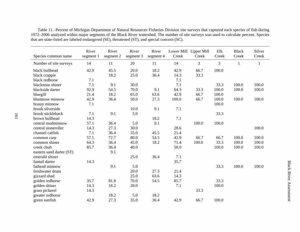
Table 11.–Percent of Michigan Department of Natural Resources Fisheries Division site surveys that captured each species of fish during 1972–2006 analyzed within major segments of the Black River watershed. The number of site surveys was used to calculate percent. Species that are state-listed are labeled endangered (SE), threatened (ST), and special concern (SC).
Species common name River
segment 1 River
segment 2 River
segment 3 River
segment 4 Lower Mill
Creek Upper Mill
Creek Elk
Creek Black Creek
Silver Creek
Number of site surveys 14 11 20 11 14 3 3 1 1
black bullhead 42.9 45.5 20.0 18.2 42.9 66.7 100.0 black crappie 18.2 25.0 36.4 14.3 33.3 black redhorse 7.1 7.1 blacknose shiner 7.1 9.1 30.0 7.1 33.3 100.0 100.0 blackside darter 92.9 54.5 70.0 9.1 64.3 33.3 100.0 100.0 100.0 bluegill 21.4 18.2 65.0 63.6 42.9 66.7 100.0 bluntnose minnow 42.9 36.4 50.0 27.3 100.0 66.7 100.0 100.0 100.0 brassy minnow 7.1 100.0 brook silverside 10.0 9.1 7.1 brook stickleback 7.1 9.1 5.0 33.3 brown bullhead 14.3 18.2 7.1 central mudminnow 57.1 36.4 5.0 9.1 100.0 100.0 central stoneroller 14.3 27.3 30.0 28.6 100.0 channel catfish 7.1 36.4 35.0 45.5 21.4 common carp 57.1 72.7 80.0 54.5 42.9 66.7 66.7 100.0 100.0 common shiner 64.3 36.4 45.0 18.2 71.4 100.0 33.3 100.0 100.0 creek chub 85.7 36.4 40.0 50.0 100.0 100.0 100.0 eastern sand darter (ST) 9.1 emerald shiner 25.0 36.4 7.1 fantail darter 14.3 35.7 fathead minnow 9.1 5.0 33.3 100.0 100.0 freshwater drum 20.0 27.3 21.4 gizzard shad 25.0 63.6 14.3 golden redhorse 35.7 81.8 70.0 54.5 85.7 33.3 golden shiner 14.3 18.2 20.0 7.1 100.0 grass pickerel 14.3 33.3 greater redhorse 18.2 5.0 18.2 green sunfish 42.9 27.3 35.0 36.4 42.9 66.7 100.0

162
Black R
iver Assessm
ent
Table 11.–Continued.
Species common name River
segment 1 River
segment 2 River
segment 3 River
segment 4 Lower Mill
Creek Upper Mill
Creek Elk
Creek Black Creek
Silver Creek
greenside darter 35.7 27.3 35.0 9.1 35.7 33.3 100.0 100.0 hornyhead chub 7.1 10.0 9.1 57.1 66.7 hybrid sunfish 9.1 10.0 7.1 Iowa darter 14.3 9.1 5.0 33.3 100.0 johnny darter 78.6 36.4 60.0 9.1 71.4 100.0 100.0 100.0 100.0 largemouth bass 7.1 18.2 30.0 63.6 21.4 66.7 least darter 100.0 100.0 mimic shiner 21.4 27.3 25.0 27.3 28.6 33.3 33.3 northern hog sucker 35.7 45.5 70.0 18.2 57.1 northern logperch 30.0 35.7 northern longear sunfish 7.1 27.3 21.4 33.3 northern pike 71.4 72.7 30.0 36.4 50.0 33.3 66.7 pugnose shiner (SE) 9.1 7.1 pumpkinseed 35.7 72.7 40.0 54.5 71.4 100.0 66.7 quillback 15.0 36.4 7.1 rainbow darter 21.4 18.2 25.0 50.0 redfin shiner 14.3 27.3 10.0 14.3 river chub 15.0 14.3 rock bass 92.9 100.0 75.0 45.5 85.7 100.0 33.3 rosyface shiner 7.1 9.1 10.0 50.0 round goby 5.0 7.1 sand shiner 21.4 18.2 20.0 14.3 shorthead redhorse 9.1 15.0 18.2 7.1 silver redhorse 7.1 18.2 15.0 36.4 7.1 smallmouth bass 28.6 63.6 60.0 36.4 71.4 spotfin shiner 28.6 27.3 45.0 27.3 35.7 spottail shiner 10.0 18.2 spotted sucker 5.0 36.4 stonecat 50.0 27.3 40.0 9.1 50.0 33.3 100.0 100.0 striped shiner 7.1 21.4 100.0 100.0 tadpole madtom 14.3 33.3 walleye 15.0 36.4 7.1

Black R
iver Assessm
ent
163
Table 11.–Continued.
Species common name River
segment 1 River
segment 2 River
segment 3 River
segment 4 Lower Mill
Creek Upper Mill
Creek Elk
Creek Black Creek
Silver Creek
lake chubsucker 5.0 white bass 15.0 36.4 7.1 white crappie 36.4 35.0 9.1 14.3 white perch 5.0 33.3 white sucker 92.9 81.8 60.0 27.3 64.3 100.0 100.0 100.0 yellow bullhead 45.5 20.0 27.3 42.9 66.7 yellow perch 14.3 18.2 35.0 54.5 14.3

Black River Assessment
164
Table 12.–Relative abundance (fraction of total found) of native mussel species found in the Black River (St. Clair and Sanilac Counties) during summer 2003 by staff of Michigan Natural Features Inventory. Species that are state-listed are labeled endangered (SE), threatened (ST), and special concern (SC).
Common name Scientific name Relative abundance
elktoe (SC) Alasmidonta marginata 0.041 slippershell (ST) Alasmidonta viridis 0.003 threeridge Amblema plicata 0.481 cylindrical papershell Anodontoides ferussacianus Shell only spike Elliptio dilatata 0.003 Wabash pigtoe Fusconaia flava 0.012 wavy-rayed lampmussel (ST) Lampsilis fasciola Shell only fatmucket Lampsilis siliquoidea 0.076 pocketbook Lampsilis ventricosa 0.021 white heelsplitter Lasmigona complanata 0.228 creek heelsplitter Lasmigona compressa 0.008 fluted-shell Lasmigona costata 0.058 fragile papershell Leptodea fragilis 0.008 round pigtoe (SC) Pleurobema sintoxia Shell only pink heelsplitter Potamilus alatus 0.005 kidney-shell Ptychobranchus fasciolaris 0.001 giant floater Pyganodon grandis 0.033 mapleleaf Quadrula quadrula 0.003 salamander mussel (SE) Simpsonaias ambigua 0.001 strange floater Strophitus undulatus 0.018 deertoe Truncilla truncata Shell only rainbow (SC) Villosa iris Shell only

Black R
iver Assessm
ent
165
Table 13.–Number of native mussels per square meter at five locations in the Black River during summer 2005. Beard Road is the most downstream site and Applegate Road the most upstream. Data were taken from Sweet 2005. Species that are state-listed are labeled endangered (SE), threatened (ST), and special concern (SC); federal-listed endangered are labeled (Fed E).
Common name Scientific name South of Beard
Road (3) Comstock and Jeddo Road (2)
Galbraith Line Road (5)
Sheridan Line Road (4)
Applegate Road (6)
three-ridge Amblema plicata 0.00 0.00 0.17 0.00 4.51 Wabash pigtoe Fusconaia flava 0.00 0.00 0.22 0.00 3.17 white heelsplitter Lasmigona complanata 0.15 0.00 0.50 0.27 0.25 giant floater Pyganodon grandis 0.00 0.00 0.00 0.00 0.38 deertoe Truncilla truncata 0.37 0.00 0.00 0.00 0.00 fragile papershell Leptodea fragilis 0.30 0.00 0.00 0.00 0.00 elktoe (SC) Alasmidonta marginata 0.00 0.00 0.22 0.27 0.06 pink heelsplitter Potamilus alatus 0.22 0.00 0.00 0.00 0.00 fluted shell Lasmigona costata 0.07 0.00 0.11 0.18 0.19 fatmucket Lampsilis siliquoidea 0.00 0.00 0.17 0.09 0.19 plain pocketbook Lampsilis cardium 0.15 0.00 0.00 0.00 0.00 rainbow (SC) Villosa iris 0.00 0.00 0.00 0.09 0.00 mapleleaf Quadrula quadrula 0.07 0.00 0.00 0.00 0.00 creeper Strophitus undulatus 0.07 0.00 0.00 0.00 0.00
Total 1.41 0.00 1.39 0.89 8.76
creek heelsplitter Lasmigona compressa Live in qualitative sample northern riffleshell (SE; Fed E) Epioblasma torulosa Dead shells only kidneyshell Ptychobranchus fasciolaris Dead shells only wavy-rayed lamp mussel (ST) Lampsilis fasciola Dead shells only round pigtoe (SC) Pleurobema sintoxia Dead shells only spike Elliptio dilatata Dead shells only slippershell (ST) Alasmidonta viridis Dead shells only

Black River Assessment
166
Table 14.–List of reptiles and amphibians found in the Black River watershed (Harding 1997). Species that are state-listed are labeled endangered (SE), threatened (ST), and special concern (SC).
Common name Scientific name
Turtles snapping turtle Chelydra serpentine common musk turtle Sternotherus odoratus spotted turtle (ST) Clemmys guttata Blanding’s turtle Emydoidea blandingii common map turtle Graptemys geographica painted turtle Chrysemys picta spiny softshell Apalone spinifera
Lizards five-lined skink Eumeces fasciatus
Snakes northern water snake Nerodia sipedon queen snake Regina septemvittata brown snake Storeria dekayi northern red-bellied snake Storeria occipitomaculata occipitomaculata common garter snake Thamnophis sirtalis sirtalis Butler’s garter snake Thamnophis butleri northern ribbon snake Thamnophis sauritus septentrionalis northern ringneck snake Diadophis punctatus edwardsi eastern hognose snake Heterodon platirhinos blue racer Coluber constrictor foxii eastern fox snake Elaphe vulpine gloydi eastern milk snake Lampropeltis triangulum triangulum eastern smooth green snake Opheodrys vernalis eastern massasauga rattlesnake Sistrurus catenatus catenatus
Salamanders mudpuppy Necturus maculosus maculosus eastern newt Notophthalmus viridescens spotted salamander Ambystoma maculatum blue-spotted salamander Ambystoma laterale red-backed salamander Plethodon cinereus
Frogs and Toads eastern American toad Bufo americanus americanus Blanchard’s cricket frog (ST) Acris crepitans blanchardi striped chorus frog Pseudacris triseriata northern spring peeper Pseudacris crucifer crucifer gray treefrog Hyla versicolor bullfrog Rana catesbeiana green frog Rana clamitans melanota wood frog Rana sylvatica northern leopard frog Rana pipiens pickerel frog Rana palustris

Black River Assessment
167
Table 15–List of breeding birds in the Black River watershed arranged by frequency of observed nesting activity (data compiled from Breeding Bird Atlas Explorer 2008). Species that are state-listed are labeled endangered (SE), threatened (ST), and special concern (SC).
Common name Scientific name Frequency
Song Sparrow Melospiza melodia 86 American Robin Turdus migratorius 83 European Starling Sturnus vulgaris 82 Red-winged Blackbird Agelaius phoeniceus 80 House Sparrow Passer domesticus 79 Barn Swallow Hirundo rustica 77 Mourning Dove Zenaida macroura 77 Killdeer Charadrius vociferus 74 Common Grackle Quiscalus quiscula 73 American Goldfinch Cardeulis tristis 70 Savannah Sparrow Passerculus sandwichensis 69 Brown-headed Cowbird Molothrus ater 67 American Crow Corvus brachyrhynchos 66 Eastern Kingbird Tyrannus tyrannus 66 Chipping Sparrow Spizella passerine 58 Eastern Meadowlark Sturnella magna 58 Cedar Waxwing Bombycilla cedrorum 57 Gray Catbird Dumetella carolinensis 55 Horned Lark Eremophila alpestris 55 Bobolink Dolichonyx oryzivorus 54 Northern Cardinal Cardinalis cardinalis 54 Yellow Warbler Dendroica petechia 53 Common Yellowthroat Geothlypis trichas 50 Tree Swallow Tachycineata bicolor 50 Blue Jay Cyanocitta cristata 49 Yellow-shafted Flicker Colaptes auratus 47 House Wren Troglodytes aedon 46 Ring-necked Pheasant Phasianus colchicus 46 Rock Pigeon Columba livia 44 Wood Thrush Hylocichla mustelina 44 Northern Bobwhite Colinus virginianus 42 Rose-breasted Grosbeak Pheucticus ludovicianus 42 Baltimore Oriole Icterus galbula 41 Brown Thrasher Toxostoma rufum 40 Great Crested Flycatcher Myiarchus crinitus 40 Turkey Vulture Cathartes aura 40 Downy Woodpecker Picoides pubescens 39 Black-capped Chickadee Parus atricapillus 38 Indigo Bunting Passerina cyanea 38 Red-tailed Hawk Buteo jamaicensis 38 Red-eyed Vireo Vireo olivaceus 37 Willow Flycatcher Empidonax traillii 37 American Kestrel Falco sparverius 35 Field Sparrow Spizella pusilla 31 Mallard Anas platyrhynchos 31 Warbling Vireo Vireo gilvus 31

Black River Assessment
168
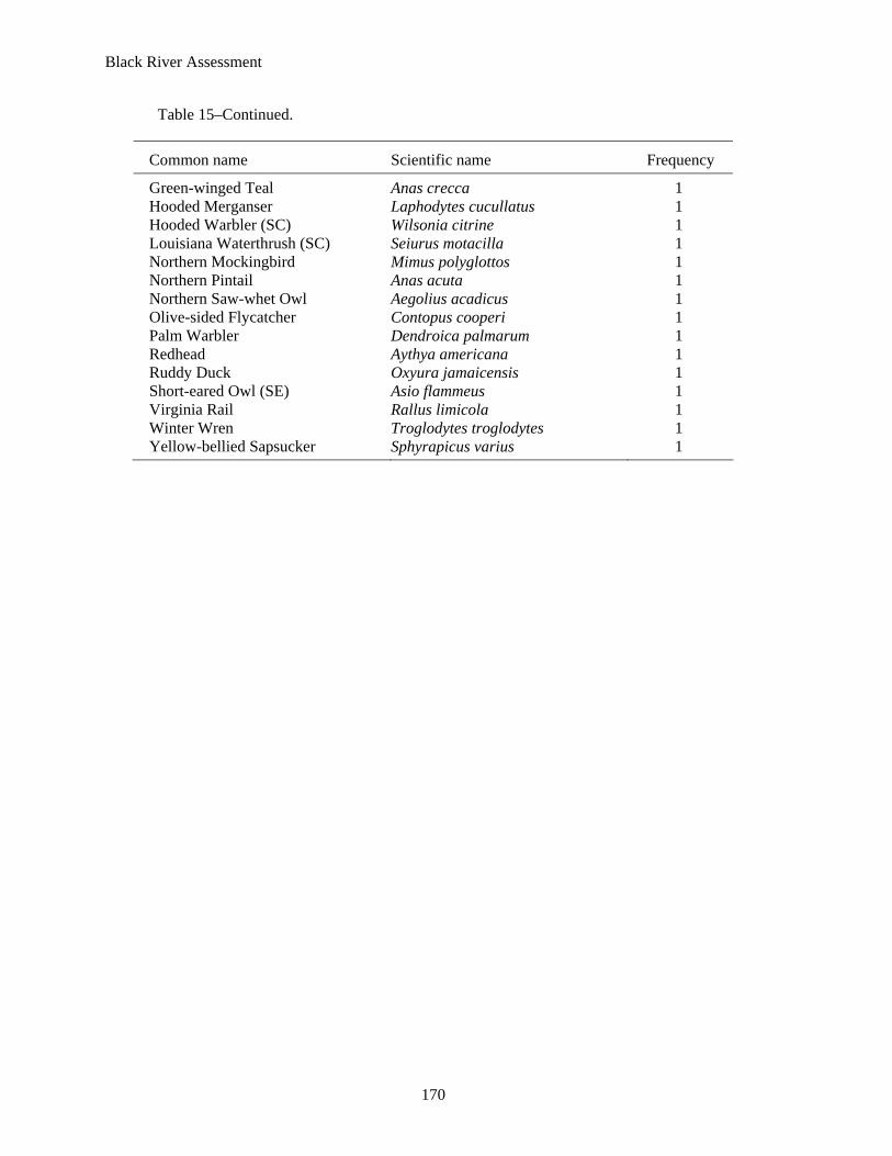
Table 15–Continued.
Common name Scientific name Frequency
Eastern Bluebird Sialia sialis 29 Eastern Towhee Pipilo erythrophthalmus 29 Eastern Wood-pewee Contopus virens 29 White-breasted Nuthatch Sitta carolinensis 29 Vesper Sparrow Pooecetes gramineus 28 Belted Kingfisher Ceryle alcyon 27 Bank Swallow Riparia riparia 26 Great Blue Heron Ardea herodias 25 Eastern Phoebe Sayornis phoebe 24 Northern Harrier (SC) Circus cyaneus 24 Ruby-throated Hummingbird Archilochus colubris 23 Green Heron Butorides striatus 22 Tufted Titmouse Parus bicolor 21 Eastern Screech-owl Otus asio 20 Northern Rough-winged Swallow Stelgidopteryx serripennis 20 Ovenbird Seiurus aurocapillus 20 Chimney Swift Chaetura pelagica 19 Red-bellied Woodpecker Melanerpes carolinus 19 Canada Goose Branta canadensis 18 House Finch Carpodacus mexicanus 18 Spotted Sandpiper Actitis macularia 18 Veery Catharus fuscescens 18 American Redstart Setophaga ruticilla 17 American Woodcock Scolopax minor 17 Hairy Woodpecker Picoides villosus 17 Wood Duck Aix sponsa 17 Cliff Swallow Petrochelidon pyrrhonata 16 Purple Martin Progne subis 16 Least Flycatcher Epidonax minimus 15 Northern Flicker Colaptes auratus 15 Red-headed Woodpecker Melanerpes erythrocephalus 15 Black-billed Cuckoo Coccyzus erythropthalmus 12 Blue-gray Gnatcatcher Polioptila caerulea 12 Scarlet Tanager Piranga olivacea 12 Wild Turkey Meleagris gallopavo 12 Mourning Warbler Oporornis philadelphia 11 Blue-winged Warbler Vermivora pinus 10 Alder Flycatcher Empidonax alnorum 9 Chestnut-sided Warbler Dendroica pensylvanica 8 Grasshopper Sparrow (SC) Ammodramus savannarum 8 Great Horned Owl Bubo virginianus 8 Purple Finch Carpodacus purpureus 8 Ruffed Grouse Bonasa umbellus 8 Swamp Sparrow Melospiza georgiana 8 Yellow-billed Cuckoo Coccyzus americanus 8 Brewer’s Blackbird Euphagus cyanocephalus 7 Cooper’s Hawk (SC) Accipiter cooperii 7 Black-and-white Warbler Mniotilta varia 6

Black River Assessment
169
Table 15–Continued.
Common name Scientific name Frequency
Ring-billed Gull Larus delawarensis 6 Sedge Wren Cistothorus platensis 6 Upland Sandpiper Bartramia longicauda 6 Clay-colored Sparrow Spizella pallida 5 Golden-winged Warbler Vermivora chrysoptera 5 Sandhill Crane Grus canadensis 5 Sora Porzana carolina 5 Yellow-throated Vireo Vireo flavifrons 5 Black-throated Green Warbler Dendroica virens 4 Blue-winged Teal Anas discors 4 Common Nighthawk Chordeiles minor 4 Marsh Wren (SC) Cistothorus palustris 4 Nashville Warbler Vermivora ruficapilla 4 Acadian Flycatcher Empidonax virescens 3 Broad-winged Hawk Buteo platypterus 3 Henslow's Sparrow (SE) Ammodramus henslowii 3 Lincoln's Sparrow Melospiza lincolnii 3 Orchard Oriole Icterus spurius 3 Pied-billed Grebe Podilymbus podiceps 3 Pileated Woodpecker Dryocopus pileatus 3 Red-shouldered Hawk (ST) Buteo lineatus 3 Whip-poor-will Caprimulgus vociferus 3 Wilson's Snipe Gallinago gallinago 3 American Coot Fulica americana 2 Blackburnian Warbler Dendroica fusca 2 Brown Creeper Certhia americana 2 Cerulean Warbler (ST) Dendroica cerulean 2 Dark-eyed Junco Junco hyemalis 2 Dickcissel (SC) Spiza americana 2 Magnolia Warbler Dendroica magnolia 2 Northern Parula Parula americana 2 Northern Shoveler Anas clypeata 2 Northern Waterthrush Seiurus noveboracensis 2 Pine Warbler Dendroica pinus 2 Sharp-shinned Hawk Accipiter striatus 2 White-throated Sparrow Zonotrichia albicollis 2 Yellow-breasted Chat Icteria virens 2 Yellow-rumped Warbler Dendroica coronata 2 Bald Eagle Heliaeetus leucocephalus 1 Barred Owl Strix varia 1 Black-throated Blue Warbler Dendroica caerulescens 1 Blue-headed Vireo Vireo solitarius 1 Brewster's Warbler Vermivora sp. hybrid 1 Canada Warbler Wilsonia canadensis 1 Carolina Wren Thryotherus ludovicianus 1 Common Merganser Mergus merganser 1 Common Moorhen Gallinula chloropus 1 Forster's Tern (ST) Sterna forsteri 1
Black River Assessment
170
Table 15–Continued.
Common name Scientific name Frequency
Green-winged Teal Anas crecca 1 Hooded Merganser Laphodytes cucullatus 1 Hooded Warbler (SC) Wilsonia citrine 1 Louisiana Waterthrush (SC) Seiurus motacilla 1 Northern Mockingbird Mimus polyglottos 1 Northern Pintail Anas acuta 1 Northern Saw-whet Owl Aegolius acadicus 1 Olive-sided Flycatcher Contopus cooperi 1 Palm Warbler Dendroica palmarum 1 Redhead Aythya americana 1 Ruddy Duck Oxyura jamaicensis 1 Short-eared Owl (SE) Asio flammeus 1 Virginia Rail Rallus limicola 1 Winter Wren Troglodytes troglodytes 1 Yellow-bellied Sapsucker Sphyrapicus varius 1

Black River Assessment
171
Table 16.–List of 42 mammals found in the Black River watershed (Burt 1957). Species that are state-listed are labeled endangered (SE), threatened (ST), and special concern (SC).
Common name Scientific name
opossum Didelphis marsupialis eastern mole Scalopus aquaticus starnose mole Condylura cristata masked shrew Sorex cinereus least shrew (ST) Cryptotis parva shorttail shrew Blarina brevicauda little brown bat Myotis lucifugus Indiana bat (SE) Myotis sodalis keen myotis Myotis keeni silver-haired bat Lasionycteris noctivagans big brown bat Eptesicus fuscus red bat Lasiurus borealis hoary bat Lasiurus cinereus raccoon Procyon lotor longtail weasel Mustela frenata least weasel Mustela nivalis mink Mustela vison river otter Lutra canadensis badger Taxidea taxus striped skunk Mephitis mephitis red fox Vulpes fulva gray fox Urocyon cinereoargenteus coyote Canis latrans woodchuck Marmota monax thirteen-lined ground squirrel Citellus tridecemlineatus eastern chipmunk Tamias striatus red squirrel Tamiascuirus hudsonicus eastern gray squirrel Sciurus carolinensis eastern fox squirrel Sciurus niger southern flying squirrel Glaucomys volans beaver Castor canadensis deer mouse Peromyscus manicultatus white-footed mouse Peromyscus leucopus southern bog lemming Synaptomys cooperi meadow vole Microtus pennsylvanicus woodland (pine) vole Pitymys pinetorum muskrat Ondatra zibethica Norway rat Rattus norvegicus house mouse Mus musculus meadow jumping mouse Zapus hudsonius eastern cottontail Sylvilagus floridanus whitetail deer Odocoileus virginianus

Black River Assessment
172
Table 17.–Numbers of eight fish species stocked each year in the Black River watershed by the Michigan Department of Natural Resources. These fish were stocked in the lower section of Mill Creek, three sections of the Black River, and 40th Street Pond to boost their local populations and improve sport fishing success.
Year stocked Species
Number stocked River section
Number of sites
1992 Black crappie 75 Section 2 1 1980 Bluegill 18,000 Section 4 1 1980 Channel catfish 44 Section 4 1 1982 Channel catfish 91 Section 2 2 1983 Channel catfish 70 Section 2 1 1986 Channel catfish 44,000 Section 2 5 1986 Channel catfish 52,017 Section 3 5 1987 Channel catfish 14,390 Section 2 4 1987 Channel catfish 23,860 Section 3 5 1988 Channel catfish 17,070 Section 2 4 1988 Channel catfish 23,860 Section 3 5 1979 Largemouth bass 3,600 Section 4 1 1980 Largemouth bass 1,560 Section 4 1 1991 Largemouth bass 67 Section 4 1 1992 Largemouth bass 39 Section 4 1 2001 Largemouth bass 48 Section 4 1 1980 Northern pike 66,250 Section 4 1 1986 Northern pike 16,500 Section 2 4 1986 Northern pike 17,500 Section 3 5 1987 Northern pike 4,870 Section 2 2 1987 Northern pike 3,350 Section 3 1 1988 Northern pike 1,000 Section 2 1 1988 Northern pike 4,310 Section 3 2 1991 Northern pike 3,000 Section 2 1 1991 Northern pike 4,500 Section 4 1 1993 Northern pike 1,500 Section 2 1 1993 Northern pike 2,250 Section 4 1 1993 Redear sunfish 20,979 40th Street Pond 1 1994 Redear sunfish 10,000 40th Street Pond 1 1995 Redear sunfish 20,912 40th Street Pond 1 1984 Smallmouth bass 5,442 Lower Mill Creek 10 1986 Smallmouth bass 262 Section 2 2 1986 Smallmouth bass 262 Section 3 2 1986 Walleye 600 Section 2 1 1986 Walleye 22 Section 3 1 1987 Walleye 2,558 Section 2 3

Black River Assessment
173
Table 18.–Number of rainbow trout stocked each year in the Black River watershed by the Michigan Department of Natural Resources. These fish were stocked in the lower section of Mill Creek and Black River to encourage their use of suitable habitat in the St. Clair River and southern Lake Huron.
Year stocked Number stocked River section Number of sites
1981 30,000 Lower Mill Creek 1 1982 20,000 Lower Mill Creek 2 1983 20,000 Lower Mill Creek 1 1984 10,000 Lower Mill Creek 1 1985 15,000 Lower Mill Creek 1 1986 20,000 Lower Mill Creek 1 1987 20,020 Lower Mill Creek 1 1987 8,640 Segment 4 1 1988 17,300 Lower Mill Creek 1 1989 14,310 Lower Mill Creek 1 1989 30,000 Segment 4 1 1990 12,920 Lower Mill Creek 1 1991 12,800 Lower Mill Creek 1 1992 14,000 Lower Mill Creek 1 1993 14,500 Lower Mill Creek 1 1994 15,850 Lower Mill Creek 1 1995 14,500 Lower Mill Creek 2 1996 14,500 Lower Mill Creek 1 1997 16,000 Lower Mill Creek 1 1998 15,084 Lower Mill Creek 1 1999 15,580 Lower Mill Creek 1 2000 15,397 Lower Mill Creek 1 2001 15,000 Lower Mill Creek 1 2002 15,752 Lower Mill Creek 1 2003 16,002 Lower Mill Creek 1 2004 16,000 Lower Mill Creek 1 2005 10,200 Lower Mill Creek 1 2006 11,094 Lower Mill Creek 1 2007 10,100 Lower Mill Creek 1

Black River Assessment
174
Table 19.–Number of brown trout stocked each year in the Black River watershed by the Michigan Department of Natural Resources. These fish were stocked in Segment 4 of the river to encourage their use of suitable habitat in the St. Clair River and southern Lake Huron.
Year stocked Number stocked Number of sites
1980 2,500 1 1981 25,000 1 1982 22,500 1 1983 20,000 2 1984 38,000 2 1985 35,600 2 1986 49,800 2 1987 35,100 2 1988 20,044 2 1989 40,180 2 1990 19,998 3 1991 25,000 1 1992 19,400 1 1993 35,402 2 1994 20,180 2 1995 18,550 1 1996 18,742 1 1997 19,995 1 1998 19,500 1 1999 19,990 1 2000 23,980 2 2001 16,000 2 2002 22,600 2 2003 24,000 2 2004 20,000 1 2005 20,000 1 2006 25,000 3 2007 6,433 1

Black River Assessment
175
Table 20.–Partner agencies, current activities, and products implemented by St. Clair County to increase public awareness of watershed issues and management plans (Jurs 2005).
Partner agencies Blue Water Land Conservancy Binational Public Advisory Council (BPAC) East Michigan Environmental Action Council Friends of the St. Clair River Michigan Farmland and Community Alliance Michigan Farm Bureau Southeast Michigan Land Conservancy United States Department of Agriculture USFWS Partners for Fish and Wildlife Program Michigan Department of Environmental Quality
Activities and products Blue Watershed Newsletter Watershed Management Brochure Southeast Michigan Partners for Clean Water Mass Media Efforts Tributary /Watershed Road Signs River Day Earth Fair “Water Quality” Table-Top Exhibit Municipal Newsletter Articles Storm Water Website “Adopt-A-Stream” Program MDEQ Pollution Prevention Programs Storm Drain/Curb Marking Program “Pollution Solutions” Presentation 24-Hour Water Quality Hotline OSDS Maintenance Brochure IDEP Brochure Water Quality Magnet “Improving Water Quality” Presentations Children’s Activity Booklet Household Hazardous Waste Collection Program Riparian Management Brochure Beach Brochure Home *A*Syst Workshops Chamber of Commerce materials WAG Meetings

Black River Assessment
176
This page was intentionally left blank.

Black River Assessment
177
REFERENCES
Albert, D.A. 1995. Regional landscape ecosystems of Michigan, Minnesota, and Wisconsin: a working map and classification. General Technical Report NC-178. St. Paul, MN: U.S. Department of Agriculture, Forest Service, North Central Forest Experiment Station. Available online http://www.npwrc.usgs.gov/resource/1998/rlandscp/rlandscp.htm (Version 03JUN98, January 2003).
Anonymous. 2000. Michigan stream classification: 1967 system. Chapter 20 in Schneider, James C. (ed.) 2000. Manual of fisheries survey methods II: with periodic updates. Michigan Department of Natural Resources, Fisheries Special Report 25, Ann Arbor.
Badra, P.J., and R.R. Gofbrth. 2003. Freshwater mussel surveys of Great Lakes tributary rivers in Michigan. Michigan Natural Features Inventory, publication 2003-15.
Baedke, S.J., and T.A. Thompson. 2000. A 4,700-year record of lake level and isostasy for Lake Michigan. Journal of Great Lakes Research, 26(4):416–426.
Bailey, R.M., W.C. Latta, and G.R. Smith. 2004. An Atlas of Michigan Fishes. Museum of Zoology, University of Michigan, No. 192, Ann Arbor. 215p.
Bay, J.W. 1938. Glacial history of the streams of southeastern Michigan. Bulletin 12, Cranbrook Institute of Science, Bloomfield Hills.
Beam, J.D., and J.J. Braunscheidel. 1998. Rouge River Assessment. Michigan Department of Natural Resources, Fisheries Division, Special Report 22. Ann Arbor, Michigan.
Becker, G.C. 1983. Fishes of Wisconsin. The University of Wisconsin Press, Madison.
Bednarek, A.T. 2001. Undamming rivers: a review of the ecological impacts of dam removal. Environmental Management 27:803-814.
Breeding Bird Atlas Explorer (online resource). 2008. U.S. Geological Survey Patuxent Wildlife Research Center & National Biological Information Infrastructure. <November 11, 2007>. http://www.pwrc.usgs.gov/bba. Data extracted from: Brewer, Richard, Gail A. McPeek, and Raymond J. Adams, Jr. 1991. The Atlas of Breeding Birds of Michigan. East Lansing, MI: Michigan State University Press. 594pp.Brewer, R., G. A. McPeek, and R. J. Adams, Jr. 1991. The Atlas of Breeding Birds of Michigan. Michigan State University Press, East Lansing.
Brunk, J.W. 1968. Evaluation of channel changes in St. Clair and Detroit Rivers. Water Resource Research 4:1335-1346.
Burt, W.H. 1957. Mammals of the Great Lakes Region. The University of Michigan Press, Ann Arbor.
Cleland, C.E. 1992. Rites of conquest: the history and culture of Michigan’s Native Americans. The University of Michigan Press, Ann Arbor.
Dunbar, W.F., and G.S. May. 1995. Michigan: a history of the Wolverine State. Eerdmans Publishing, Grand Rapids.

Black River Assessment
178
Farrand, W.R., and D.F. Eschman. 1974. Glaciation of the Southern Peninsula of Michigan: a review. The Michigan Academician 7:31–56.
Finkenbine, J.K., J.W. Atwater, and D.S. Mavinic. 2000. Stream health after urbanization. Journal of the American Water Resources Association 36:1149-1160.
Francis, J.T., and R.C. Haas. 2006. Clinton River Assessment. Michigan Department of Natural Resources, Fisheries Special Report 39, Ann Arbor.
Gauthreaux, S. 1995. Radar ornithology: tracking bird migration by radar. Wildbird 9(3): 38-39.
Gill, T. 2000. Mill Creek monitoring project report. Mill Creek Volunteer Monitoring Project, First Annual Report. Retrieved 17th October 2007 from the World Wide Web: http://www.millcreekmonitoring.org/reports.html.
Gill, T. 2005. The effects of dredging vs. the effects of river restoration on Mill Creek. Mill Creek Volunteer Monitoring Project, Fourth Annual Report, April 2005. Retrieved 17th October 2007 from the World Wide Web: http://www.millcreekmonitoring.org/reports.html.
Goodwin, K. 2007. Biological assessment of the Belle, Black, and Pine River watersheds Sanilac, Lapeer, and St. Clair counties, Michigan June – September 2002. Michigan Department of Environmental Quality, Water Bureau, Staff Report MI/DEQ/WB-07/069, Lansing.
Harding, J.H. 1997. Amphibians and reptiles of the Great Lakes region. The University of Michigan Press, Ann Arbor.
Harding, H.J., and J.A. Holman. 1990. Michigan Turtles and Lizards: A Field Guide and Pocket Reference. Michigan State University, Cooperative Extension Service, East Lansing.
Hay-Chmielewski, E.M, P.W. Seelbach, G.E. Whelan, and D.B. Jester, Jr. 1995. Huron River Assessment. Michigan Department of Natural Resources, Fisheries Special Report 16. Ann Arbor, Michigan.
Hubbs, C.L., and K.F. Lagler. 1947. Fishes of the Great Lakes Region. The University of Michigan Press, Ann Arbor.
Institute of Environmental Sciences. 1982. A Guide to the George Palmiter River Restoration Techniques, Miami University, Oxford, Ohio.
Johnson, C. 1982. Resource assessment of Spring Creek Drain, Potts Drain, and Elk River, Sanilac County, Michigan April 21, 1982. Michigan Department of Natural Resources, Water Quality Division, Biology Section, Lansing.
Johnson, C. 1983. Biological survey of the Black River near Croswell, Sanilac County, September 9, 1982. Michigan Department of Natural Resources, Surface Water Quality Division, Report 04326, Lansing.
Jurs, K. 2005 (Unpublished). NPDES Phase II watershed public education plan. St. Clair County, Michigan, Report COC #MIG61005, Port Huron.
Kafcas, E. 2002 (draft). Port Huron state game area master plan. Michigan Department of Natural Resources, Saginaw Bay Management Unit, Lansing.
Black River Assessment
179
Kanehl, P.D., J. Lyons, and J.E. Nelson. 1997. Changes in the habitat and fish community of the Milwaukee River, Wisconsin, following removal of the Woolen Mills Dam. North American Journal of Fisheries Management 17:387-400.
Karr, A. 2003. Minden City state game area master plan. Michigan Department of Natural Resources, Saginaw Bay Management Unit, Lansing.
Karrow, P.F. 1984. Quaternary stratigraphy and history, Great Lakes-St. Lawrence region. In Quaternary Stratigraphy of Canada—A Canadian Contribution to IGCP Project 24, Geological Survey Canada Paper 84-10:137–153.
Knutilla, R.L. 1969. Gazetteer of hydrologic data for the Black River Basin, Southeastern Michigan. United States Geological Survey, Technical Paper No. 3.
Kraft, C.E., D.M. Carlson, and M. Carlson. 2006. Inland Fishes of New York (Online), Version 4.0. Department of Natural Resources, Cornell University, and the New York State Department of Environmental Conservation.
Lahontan, Louis Armand de Lom d'Arce, baron de. 1703. New Voyages to North America. Printed for H. Bonwicke, T. Goodwin, M. Wotton, B. Tooke, and S. Manship, London.
Larson, G.J., T.V. Lowell, and N. E. Ostrom. 1994. Evidence for the Two Creeks interstade in the Lake Huron basin. Canadian Journal of Earth Sciences 31:793–797.
Larson G., and R. Schaetzl. 2001. Origin and evolution of the Great Lakes. Journal of Great Lakes Research, 27(4):518–546.
Madsen, B. 1999. Minden Bog: Nature and values of the ecosystem, and impacts of peat mining. Report to the Department of Justice, Environmental Defense Section, Environment and Natural Resources Division. Re: United States v. Bay-Housten, DJ File # 90-5-1-1-4519, Washington.
Mansfield, J.B. 1899. History of the Great Lakes. Volume I, J. H. Beers & Co., Chicago.
MDEQ. 1990. Great Lakes and Environmental Assessment Section Procedure #51: Qualitative biological and habitat survey protocols for wadable stream and rivers, April 24, 1990. Revised June 1991, August 1996, January 1997, and May 2002. Michigan Department of Environmental Quality, Surface Water Quality Division, Great Lakes and Environmental Assessment Section, Lansing.
MDNR (Michigan Department of Natural Resources, Bureau of Water Management). 1975. Black River Study: Wadhams to mouth 1973. Report No. 25060, Lansing.
MDNR (Michigan Department of Natural Resources, Surface Water Quality Division). 1990. A Macroinvertebrate and Sediment Survey of the Black River in the vicinity of Port Huron, St. Clair County, Michigan, November 15, 1988. MI/DNR/SWQ-90/026, Lansing.
MWRC (Michigan Department of Conservation – Water Resources Commission). 1968. Biological surveys of the Black River vicinity of Michigan Sugar Company Croswell, Sanilac County, Michigan. Report No. 001370, Lansing.
Miller, D.G., and P.T. Simons. (1918). Drainage in Michigan. Publ. 28 Michigan Geological and Biological Survey Geological Series 23.
Black River Assessment
180
Morse, D. 1993. A biological survey of Berry Drain, Sanilac County, June 22, 1992. Michigan Department of Natural Resources, Great Lakes and Environmental Assessment Section, Staff Report MI/DNR/SWQ-92-311, Lansing.
Mozola, A.J. 1953. A survey of the groundwater resources in Oakland County, Michigan. Michigan Department of Conservation, Geological Survey Division, Publication 48, Part II, Lansing.
Pecor, C., and R. Hay. 1975. Biological survey of the Black River, Sanilac and St. Clair Counties, 1973. Michigan Water Resources Commission, Bureau of Water Management, Report 02570, Lansing.
Pflieger, W.L. 1975. The Fish of Missouri. Missouri Department of Conservation. Jefferson City.
Rosgen, D.L. 1994. A classification of natural rivers. Catena 22:169–199.
Rosgen, D.L. 1996. Applied river morphology, 2nd Ed. Wildland Hydrology, Pagosa Springs.
Schmitt, G. 2005. Biological survey of Berry Drain Sanilac County, Michigan September 21, 2004 and August 22, 2005. Michigan Department of Environmental Quality, Water Bureau, Staff Report MI/DEQ/WB-05/102, Lansing.
Schmitt, G. 2008. A biological survey of the Black River, Pine River, and Belle River watersheds located in Lapeer, Macomb, Sanilac, and St. Clair counties, Michigan, July 17-26 and September 19, 2007. Michigan Department of Environmental Quality, Water Bureau, Staff Report MI/DEQ/WB-08/050, Lansing.
Scott, W.B., and E.J. Crossman. 1973. Freshwater Fishes of Canada. Bulletin 184, Fisheries Research Board of Canada, Ottawa.
Seelbach, P.W., M.J. Wiley, J.C. Kotanchik, and M.E. Baker. 1997. A landscape-based, ecological classification for river valley segments in lower Michigan. Michigan Department of Natural Resources, Fisheries Research Report 2036, Ann Arbor.
Sommers, L.M. 1977. Atlas of Michigan. Michigan State University Press, East Lansing.
Sunday, E. 2006. Total maximum daily load for dissolved oxygen for the Berry Drain, Sanilac County. MDEQ, WB, Lansing.
Sweet, D. 2005. Freshwater mussel survey of the lower Black River, Sanilac and St. Clair counties, Michigan. Michigan Department of Natural Resources, Wildlife Division, Natural Heritage Program, unpublished report, Lansing.
The Nature Conservancy. 2007. Indicators of hydrologic alteration, user’s manual. The Nature Conservancy, Arlington, Virginia.
Trautman, M.B. 1981. The Fishes of Ohio, revised edition. Ohio State University Press, Columbus.
Trdan, R.J., and W.R. Hoeh. 1995. Relocation of two state-listed freshwater mussel species (Epioblasma torulosa rangiana and Epiobfasma triquetra) in Michigan. Freshwater Mollusk Conservation Society. Proceedings of a Upper Mississippi River Conservation Committee Symposium, Rock Island.

Black River Assessment
181
Walterhouse, M. 1994. A biological survey of the Black River St. Clair and Sanilac Counties, August 18, 1992. Michigan Department of Natural Resources, Surface Water Quality Division, Staff Report MI/DNR/SWQ-94-017, Lansing.
Wang, L., J. Lyons, and P. Kanehl. 2001. Impacts of urbanization on stream habitat and fish across multiple spatial scales. Environmental Management 28:25-266.
Wehrly, K.E., M.J. Wiley, and P.W. Seelbach. 2003. Classifying regional variation in thermal regime based on stream fish community patterns. Transactions of the American Fisheries Society 132:18-38.
Wiley, M.J., and P.W. Seelbach. 1997. An introduction to rivers – the conceptual basis for the Michigan Rivers Inventory (MRI) Project. Michigan Department of Natural Resources, Fisheries Special Report 20, Ann Arbor.
Willson, R. 1969. Biological survey of the Black River vicinity of Michigan Sugar Company, Croswell, Sanilac County, Michigan. Michigan Water Resources Commission, Bureau of Water Management, Report 01370, Lansing.
Winston, M.R., C.M. Taylor, and J. Pigg. 1991. Upstream extirpation of four minnow species due to damming of a prairie stream. Transactions of the American Fisheries Society 120:98-105.
Zanatta D.T., and Murphy R.W. 2007. Range-wide population genetic analysis of the endangered northern riffleshell mussel, Epioblasma torulosa rangiana (Bivalvia: Unionoida). Conservation Genetics 8: 1393–1404.
Zanatta D.T., and Murphy R.W. 2008. The phylogeographical and management implications of genetic population structure in the imperiled snuffbox mussel, Epioblasma triquetra (Bivalvia: Unionoida). Biological Journal of the Linnean Society 93: 371–384.
Zorn, T.G., P.W. Seelbach, E.S. Rutherford, T.C. Wills, S. Cheng, and M.J. Wiley. 2008. A regional-scale habitat suitability model to assess the effects of flow reduction on fish assemblages in Michigan streams. Michigan Department of Natural Resources, Fisheries Research Report 2089, Ann Arbor.
Philip J. Schneeberger, Editor Alan D. Sutton, Graphics Ellen S. Grove, Desktop Publishing Approved by E.M. Hay-Chmielewski

Black River Assessment
182
This page was intentionally left blank.

Black River Assessment
183
APPENDICES

Black River Assessment
184
This page was intentionally left blank.

Black River Assessment
185
Area photographed
0 3 6 9 Miles
N
Appendix A
Aerial photographs of a 1,216 acre area along the mainstem of the Black River
This appendix contains eight historical and recent aerial photographs of the same 1,216 acre area bordering a 2.1 mile stretch of the Black River. These photographs document very significant changes to the landscape and river channel caused by development and operation of a large sand and gravel surface mine that is currently expanding mining operations to the south along the river.

Black River Assessment
186
First of eight aerial photos of the Black River at Fisher Rd. in September of 1941.

Black River Assessment
187
Second of eight aerial photos of the Black River at Fisher Rd. in October of 1949.

Black River Assessment
188
Third of eight aerial photos of the Black River at Fisher Rd. in September of 1963.
Black River Assessment
189
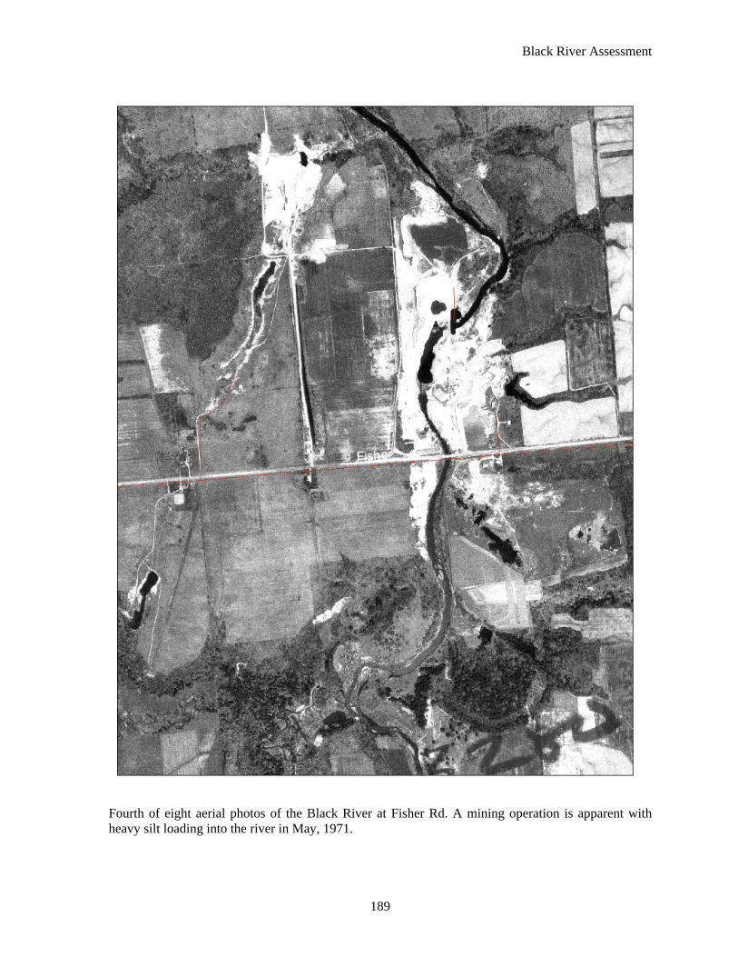
Fourth of eight aerial photos of the Black River at Fisher Rd. A mining operation is apparent with heavy silt loading into the river in May, 1971.

Black River Assessment
190
Fifth of eight aerial photos of the Black River at Fisher Rd. The mining operation has expanded with modifications apparent in the river channel in September, 1980.
Black River Assessment
191
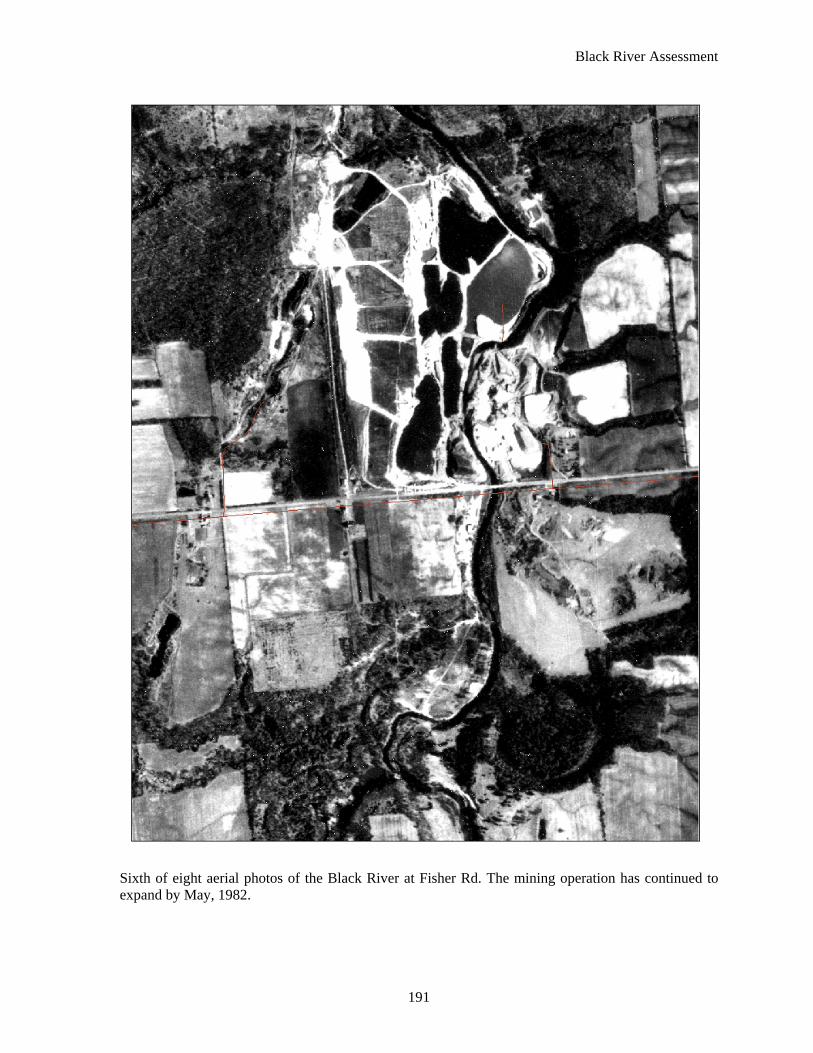
Sixth of eight aerial photos of the Black River at Fisher Rd. The mining operation has continued to expand by May, 1982.

Black River Assessment
192
Seventh of eight aerial photos of the Black River at Fisher Rd. The mining operation has continued to expand with large ponds visibly connected to the river in 1998.

Black River Assessment
193
Eighth of eight aerial photos of the Black River at Fisher Rd. The mining operation has made apparent improvements to the river channel and disconnected ponds from the river in 2005.