take yamakita - biodic.go.jp
TRANSCRIPT

International activities aroundAP‐MBON
andBiodiversity observations in AO‐marine
Take Yamakita(JAMSTEC)
• Today’s Topics
• What’s GOOS
• Whats MBON & American Activities
• APMBON Member’s Activities
• Topics in Oceania

Formally launched AP MBONStructure of organization:Steering committee:Chair: Massa Nakaoka (Akkeshi Marine Station Hokkaido University),
Costello, Shirayama, Lim, Prathep, Amri, Muslim
Secretary Office: in JAMSTECSecretary General: Takehisa Yamakitamembers in GODAC JAMSTEC (http://www.godac.jamstec.go.jp/bismal/e/)
Website under GeoBON…Fundraising, SNS …etc‐2020 Feb ODA1yr ODA 5M Yen intl. member incl. developing countries‐2020 May JSPS Kakenhi Kokusai Kyoudou b20M Yen 3‐6yrs(3.7M/yr) 3 member include Young‐2020 Oct ERDEF MoE / JSPS Kakenhi
3yr 40M Kiban b 5yr
Potential research sites (tentative)
Australia? and Pacific island?


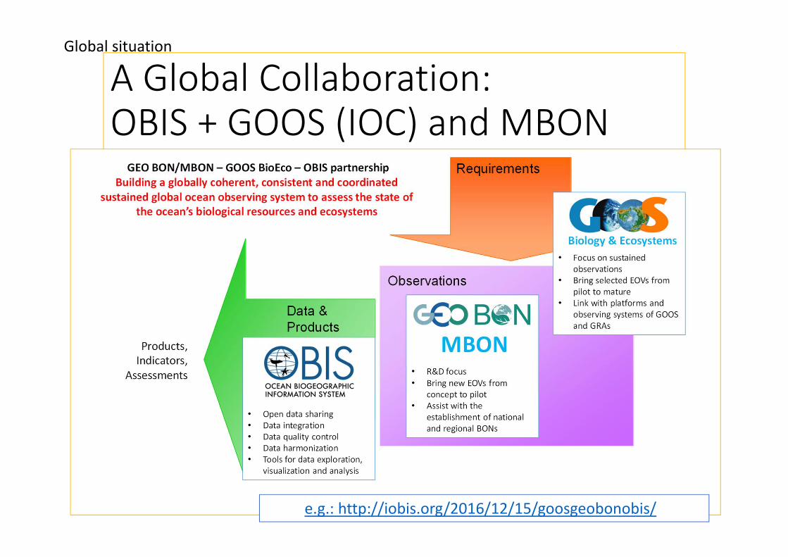
A Global Collaboration:OBIS + GOOS (IOC) and MBON
e.g.: http://iobis.org/2016/12/15/goosgeobonobis/
Global situation

GRF‐9Ninth GOOS Regional Alliances Forum 5 ‐ 7 August 2019, Tokyo, Japan • Key component of GOOS• expert panels for physics, biogeochemistry, and biology and ecosystems that synthesize across requirements and provide guidance on observing system design
• the Observations Coordination Group and the GOOS Regional Alliances that implement observing systems and ensure the flow of observations across the global networks and regional observing structures
• GOOS Projects that advance innovation and expand into new areas for the observing system
• Core coordination through the GOOS Steering Committee and a distributed GOOS Offic.

Strategic objectives• Deepening Engagement and ImpactDeepen engagement and partnership from observations to end users to advance the use and impact of the observations and demonstrate their benefits
• 1. Strengthen partnerships to improve delivery of forecasts, services, and scientific assessments.
• 2. Build advocacy and visibility with stakeholders through communicating with key users and national funders.
• 3. Regularly evaluate system impact to assess fit for purpose.• 4. Strengthen knowledge and exchange around
• System Integration and DeliveryDeliver an integrated, ‘fit‐for‐purpose’ observing system built on the systems approach outlined in the Framework for Ocean Observing
• 5. Provide authoritative guidance on integrated observing system design, synthesizing across evolving requirements and identifying gaps.
• 6. Sustain, strengthen and expand observing system implementation through GOOS and partner communities, promoting standards and best practice, and developing metrics to measure success.
• 7. Ensure GOOS ocean observing data and information are findable, accessible, interoperable, and reusable, with appropriate quality and latency.
• Building for the FutureBuilding for the future through innovation, capacity development, and evolving good governance
• 8. Support innovation in observing technologies and networks.• 9. Develop capacity to ensure a broader range of beneficial stakeholder participation.• 10. Extend systematic observations to the ocean.• 11. Champion effective governance for global in situ and satellite observing, together with
partners and stakeholders

www.jcommops.org/reportcard2018
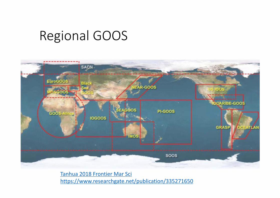
Regional GOOS
Tanhua 2018 Frontier Mar Sci https://www.researchgate.net/publication/335271650

GRA Background ReportNEAR-GOOS
Masakazu HIGAKIChair, NEAR-GOOS
Japan Meteorological Agency
GOOS Regional Forum-9, 5-7 August 2019, Tokyo, Japan
Example from meeting documentshttp://ioc-unesco.org/index.php?option=com_oe&task=viewEventDocs&eventID=2422

General information• Type: Intergovernmental network• Funding characterization: Project funded• GRA leadership (Chair/coordinator) and contact:
• Chair: Masakazu HIGAKI (election: 2018, term: 2 years)• E‐mail: [email protected]
• IOC/WESTPAC Coordinating Committee (CC) for NEAR‐GOOS• 2 members from each country
• Secretariat:• Mr Wenxi Zhu, Technical Secretary, IOC/WESTPAC
• E‐mail: [email protected]
• Website: http://iocwestpac.org/north‐east‐asian‐regional‐goos/172.html
• Membership: 8 organizations in China, Japan, Korea, and Russia• Terms of Reference: http://iocwestpac.org/north‐east‐asian‐regional‐goos/173.html
• Meetings: (NEAR‐GOOS CC)• Past 2: 18th Session, 21‐22 Nov. 2017, Fuchou, China
19th Session, 14‐15 Nov. 2018, Bangkok, Thailand• Next: 20th Session, Nov. 2019, Busan, Korea

In what areas would the GRA like to be active?Value chain element What resource would be needed?
Observations implementation
Continuation of pilot projects
Data management Continuation and enhancement of NEAR‐GOOS Databases
Forecasting Release of NEAR‐GOOS Ocean Forecasting Systems (OFS)
Service / information delivery
Continuation and enhancement of NEAR‐GOOS Databases
Capacity development of members
should be considered
Outreach / ocean literacy should be considered (e.g. through sessions in WESTPAC Science Symposia)

NEAR‐GOOS DatabasesChina
NRTDB NDMDB
Japan (incl. Regional DB)RRTDB RDMDB
Rep. of KoreaNRTDB NDMDB
RussiaNRTDB NDMDB

Regional and National DBsCountry Database Responsible
organization URL
JapanRegional RTDB JMA https://www.data.jma.go.jp/gmd/goos/data
/database.html
Regional DMDB JODC http://near‐goos1.jodc.go.jp
ChinaNational RTDB NMEFC http://neargoos.nmefc.cn:8080/exchange/i
ndex.jsp
National DMDB NMDIS http://near‐goos.nmdis.org.cn
KoreaNational RTDB KHOA http://www.khoa.go.kr/neargoos/
National DMDB NIFS http://www.nifs.go.kr/kodc/eng/01_about/02.jsp
RussiaNational RTDB FERHRI http://ferhri.org/en/our‐projects/near‐
goos.html
National DMDB POI http://pacificinfo.ru/near‐goos/
• Now 8 DBs work well.

1. Developing an MBON Implementation Plan2. Data Management3. Developing EBVs

MBON is a “coalition of the willing” who agree to share knowledge and know-how to evaluate changes of biodiversity in the ocean, including
data, products, protocols and methods, data systems and software.
The MBON seeks to establish a process for sustained, operational
measurements of biodiversity around the globe. These observations should
be collected in standardized ways, and the information shared, in order to
understand how biodiversity is changing.
The ultimate objective is to understand how and why life in the ocean is changing, how local changes relate to changes taking place over larger regions, and to provide information to help define options for government and intergovernmental policies relevant to the conservation
and sustainable use of marine biodiversity.
MBON Vision
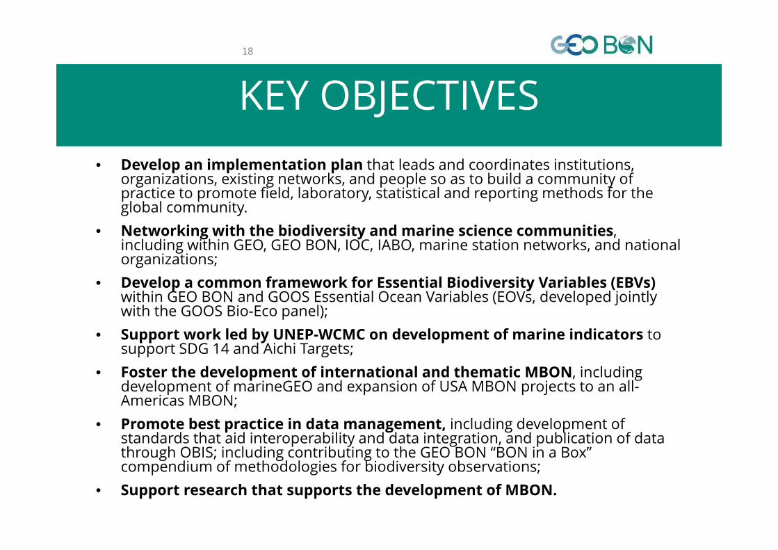
KEY OBJECTIVES18
• Develop an implementation plan that leads and coordinates institutions, organizations, existing networks, and people so as to build a community of practice to promote field, laboratory, statistical and reporting methods for the global community.
• Networking with the biodiversity and marine science communities, including within GEO, GEO BON, IOC, IABO, marine station networks, and national organizations;
• Develop a common framework for Essential Biodiversity Variables (EBVs)within GEO BON and GOOS Essential Ocean Variables (EOVs, developed jointly with the GOOS Bio-Eco panel);
• Support work led by UNEP-WCMC on development of marine indicators to support SDG 14 and Aichi Targets;
• Foster the development of international and thematic MBON, including development of marineGEO and expansion of USA MBON projects to an all-Americas MBON;
• Promote best practice in data management, including development of standards that aid interoperability and data integration, and publication of data through OBIS; including contributing to the GEO BON “BON in a Box” compendium of methodologies for biodiversity observations;
• Support research that supports the development of MBON.

Success data publication

• The U.S. MBON projects are integrating independent historical and current biology and ecosystem surveys with new observations, and expanding application of remote sensing methods, novel molecular (eDNA) technologies, traditional environmental research tools, and coordinated experiments.
U.S. MBON ContactsGabrielle Canonico, U.S. MBON Program ManagerFrank Muller-Karger, U.S. MBON Team LeaderEnrique Montes, MBON Pole to Pole
SponsorsU.S. MBON projects have been funded since 2013 under the National Oceanographic Partnership Program (FY14 RFP NOAA-NOS-IOOS-2014-2003803 and FY19 ONR Announcement # N00014-18-S-B007).U.S. MBON represents a partnership among NOAA, NASA, BOEM, and ONR, with coordination provided by the U.S. Integrated Ocean Observing System (U.S. IOOS) Program Office.

MBON Pole to Pole Project
• Members specialty (over 38)• Rocky shores• Sandy beaches • Environmental data• Data science
• Uploading to OBIS
https://marinebon.org/pages/pole_to_pole/

Please see the website of MBON US project
• MBON• https://marinebon.org/pages/us_projects/
• MBON data portal• https://mbon.ioos.us/
• P2P• https://marinebon.org/p2p/index.html
• Data and website• https://github.com/marinebon

https://mbon.ioos.us/

http://mbon.marine.usf.edu/

https://marinebon.org/p2p‐dashboard/

Revive past activities to observe temporal changes
Over 10 years since CoML...-temporal change?-improve of the technique(such as DNA & Camera)-Pole to Pole biodiversity pattern
Use of the information such as -ecosystem services-EBSA-indicator of the threat
Location of the past study sites
Yam
akita
et a
l. (2
017)
Mar
ine
Polic
y
Project : Coastal biodiversity assessment
Proposed EBSA usingexisting &literatureextracteddata

Facilitate broad scale researches and production of infrastructure
Present data...-Some are still not good enough -Some need temporal data
Ways to improve-image recognition-eDNA-survey using drone -literature… etc
• Update the maps ofseagrasses, algae and coral reefs & build GIS database
More accurate classification of seagrass Yamakita et al. 2019 Bot Mar
Coral reef habitat data in AP region using ALOS/AVNIR2(National Institute for Environment Studies (NIES) and Asia Air Survey Co.,ltd)
Project : Coastal biodiversity assessment

Topics in AO: What’s happening in the Australia monitoring...marine Drone?
• http://marine.acfr.usyd.edu.au/fieldwork/imos‐auv‐facility/
• https://www.sims.org.au/page/93/autonomous‐underwater‐vehicle

https://auv.aodn.org.au/auv/

https://www.nespmarine.edu.au/https://research.science.mq.edu.au/capstan/wp‐content/uploads/sites/18/2016/01/NMSP‐2015‐2025‐report.pdfhttps://soe.environment.gov.au/theme/marine‐environment/topic/2016/state‐and‐trends‐marine‐biodiversity‐species‐groups National Marine Science | Plan Driving
the development of Australia’s blue economy 2015–2025
Spawning biomass of the east coast population of orange roughy, 1980–2015