taliao formation nanchuang formation taliao formation...
TRANSCRIPT


1 2
Trace fossils in the Northeast Coast of Taiwan
Introduction
Along the northeast coast of Taiwan, Oligocene to Pliocene sedi-ments deposited in littoral to shallow marine environments have been up-lifted and tilted by tectonic processes related to the collision of a volcanic arc on the Philippine Sea Plate and the Eurasian continental plate (Suppe, 1984). The intense weathering and erosion caused by waves and torren-tial rains have resulted in a rugged coastline and sparse vegetation cov-er, providing detailed exposure of sedimentary and biogenic structures. These sandstones have recorded a set of tectonic and eustatic sea level changes, allowing a large number of different environmental settings to be studied. The individual beds of these strata often show characteristic ichnofossil assemblages representing different recurrent environments that are repeated several times in the succession as the sea level fell and rose.
In this field trip, we will traverse through Yehliu (stop 1) in the morning, Badouzi (stop 2), Fanziao (stop 3) and Shuinandong (stop 4) in the afternoon (Figure 1), to observe various ichnofabrics in the Mio-cene sandstones. What makes these sandstones particularly interesting is the fact that many beds are dominated by high abundances of almost monospecific assemblages, and many of the peculiar trace fossils are still unidentified and waiting to be explored.
Geological Background
Taiwan is situated at the eastern boundary of the Eurasian continent and owes its steep topography to the collision between the volcanic arc on the Philippine Sea plate, and the continental margin of the Eurasian
plate (Suppe, 1984). As a result of this collision, two north-south oriented mountain ranges have formed, the eastern representing the volcanic arc of the Philippine Sea plate, and the western range representing metamorphosed and uplifted sediment from the Eurasian passive margin (Figure 2). Because of the northwestward motion of the Philippine Sea plate, the collision between the two plates is oblique. This means that while full collision is taking place in the central parts, an incipient collision can be found in the southern parts of the island, and in the north, were the collision started, it is now in a postcollisional, collapsing phase (Shyu et al., 2005; Suppe, 1984). During the Penglai orogeny, the strata comprising Taiwan island were uplifted and deformed (Teng et al., 1991), resulting in imbricated thrust faults along the Northeast Coast (Ho, 1986). The collision in combination with the opening of the Okinawa trough has resulted in uplifting, faulting and folding of the several thousand meters thick Cenozoic sediments that were deposited in a half graben system that developed along the Eurasian continental margin as a consequence of the opening of the South China Sea (Chen, 2005).
Figure 1. A) Geological map showing the stops of the field trip along the Northeast coast of Taiwan. B) The inset map shows the location of study area in northeastern Taiwan.
Holocene Deposits
River
1 km
Syncline Axis
Fault
Pleistocene Dacite
Taliao FormationBasaltic tuff and flowTaliao Formation Shale and sandstone Massive sandstone
coal seams
Kueichulin For-mation. Tapu Member Muddy sandstone, white sandstone
Nankang Formation Sandstone, siltstone, shale
Wuchihshan Formation Alternation of sandstone and shale, coarse grained or pebbly sandstone
Mushan Formation Alternation of sandstone and shale, intercalated coal seams
Concealed Fault
Alternation of sandstoneand shale intercalated
Nanchuang Formation
Nankang FormationBasaltic tuffShihti Formation Alternation of Massive white sandstone

3 4
The Oligocene to Pliocene strata (in the Western Foothills, WF in Figure 2) in Taiwan consist of three main depositional cycles, each containing a coal-bearing and a marine unit deposited on the passive margin of the Eurasian continent. These depositional cycles extend NE-SW through Taiwan, consisting mostly of paralic to shallow marine deposits characterized by strong NW-SE facies changes (Ho, 1986; Huang, 1990). It is generally recognized that there are two major transgressive-regressive cycles in the lower upper Miocene. The Nankang and Talio Formations were deposited during transgressive periods, while the Shiti and Nanchuang Formations were deposited during regressive periods (Figure 3) (Chou, 1970; Hong and Wang, 1988; Huang, 1990). However, more detailed sequence stratigraphy studies on the Northeast Coast have revealed that there are seven higher-ordered transgressive-regressive cycles within the two major Miocene cycles (Yu and Teng, 1996).
Taliao Formation
The Miocene Taliao Formation is well exposed along the northern coast from the Yehliu peninsula to Badouzi promontory southwest of Keelung City (Stop 1 and 2). The formation is composed of a lower mudstone unit, a middle sandstone unit (the Yehliu Sandstone Member) (Ho et al., 1964), and an upper thin, interbedded sandstone and mudstone unit (Yen and Chen, 1953; Hong and Huang, 2000). The homoclinal nature of the strata results in a conspicuous cuesta topography in both areas. Within these sandstones, scattered lenses or layers of molluscs, echinoids and bryozoans occur. A few of the fossiliferous lenses are composed of in situ molluscs, mostly oysters. Accordingly, the member is interpreted as offshore bar and shoreface deposits (Figure 4) (Hong and Wang, 1988).
Figure 2. 3D tectonic framework and simplified geological map of Taiwan.
Figure 3. Stratigraphy of the Northeast coast of Taiwan in the Miocene.
Figure 4. Simplified column of the Taliao Formation (modified from Hong and Wang, 1988).
Yehliu Peninsula -Stop 1
Key points:
Piscichnus waitemata targeting Ophiomorpha, abundant Schaubcylindrichnus, possible Rorschachichnus amoeba, and enigmatic large circular congregations of Bichordites.
5 6
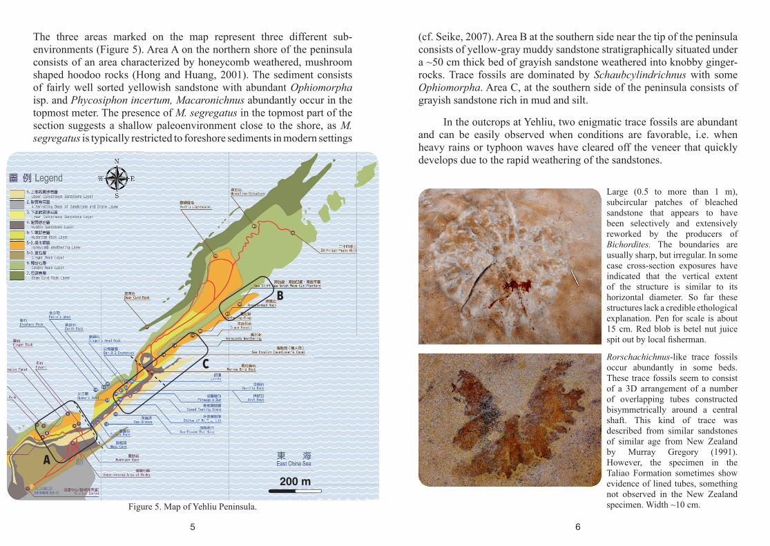
The three areas marked on the map represent three different sub-environments (Figure 5). Area A on the northern shore of the peninsula consists of an area characterized by honeycomb weathered, mushroom shaped hoodoo rocks (Hong and Huang, 2001). The sediment consists of fairly well sorted yellowish sandstone with abundant Ophiomorpha isp. and Phycosiphon incertum, Macaronichnus abundantly occur in the topmost meter. The presence of M. segregatus in the topmost part of the section suggests a shallow paleoenvironment close to the shore, as M. segregatus is typically restricted to foreshore sediments in modern settings
(cf. Seike, 2007). Area B at the southern side near the tip of the peninsula consists of yellow-gray muddy sandstone stratigraphically situated under a ~50 cm thick bed of grayish sandstone weathered into knobby ginger-rocks. Trace fossils are dominated by Schaubcylindrichnus with some Ophiomorpha. Area C, at the southern side of the peninsula consists of grayish sandstone rich in mud and silt.
In the outcrops at Yehliu, two enigmatic trace fossils are abundant and can be easily observed when conditions are favorable, i.e. when heavy rains or typhoon waves have cleared off the veneer that quickly develops due to the rapid weathering of the sandstones.
Figure 5. Map of Yehliu Peninsula.
Large (0.5 to more than 1 m), subcircular patches of bleached sandstone that appears to have been selectively and extensively reworked by the producers of Bichordites. The boundaries are usually sharp, but irregular. In some case cross-section exposures have indicated that the vertical extent of the structure is similar to its horizontal diameter. So far these structures lack a credible ethological explanation. Pen for scale is about 15 cm. Red blob is betel nut juice spit out by local fisherman.
Rorschachichnus-like trace fossils occur abundantly in some beds. These trace fossils seem to consist of a 3D arrangement of a number of overlapping tubes constructed bisymmetrically around a central shaft. This kind of trace was described from similar sandstones of similar age from New Zealand by Murray Gregory (1991). However, the specimen in the Taliao Formation sometimes show evidence of lined tubes, something not observed in the New Zealand specimen. Width ~10 cm.
A
B
C
200 m
7 8
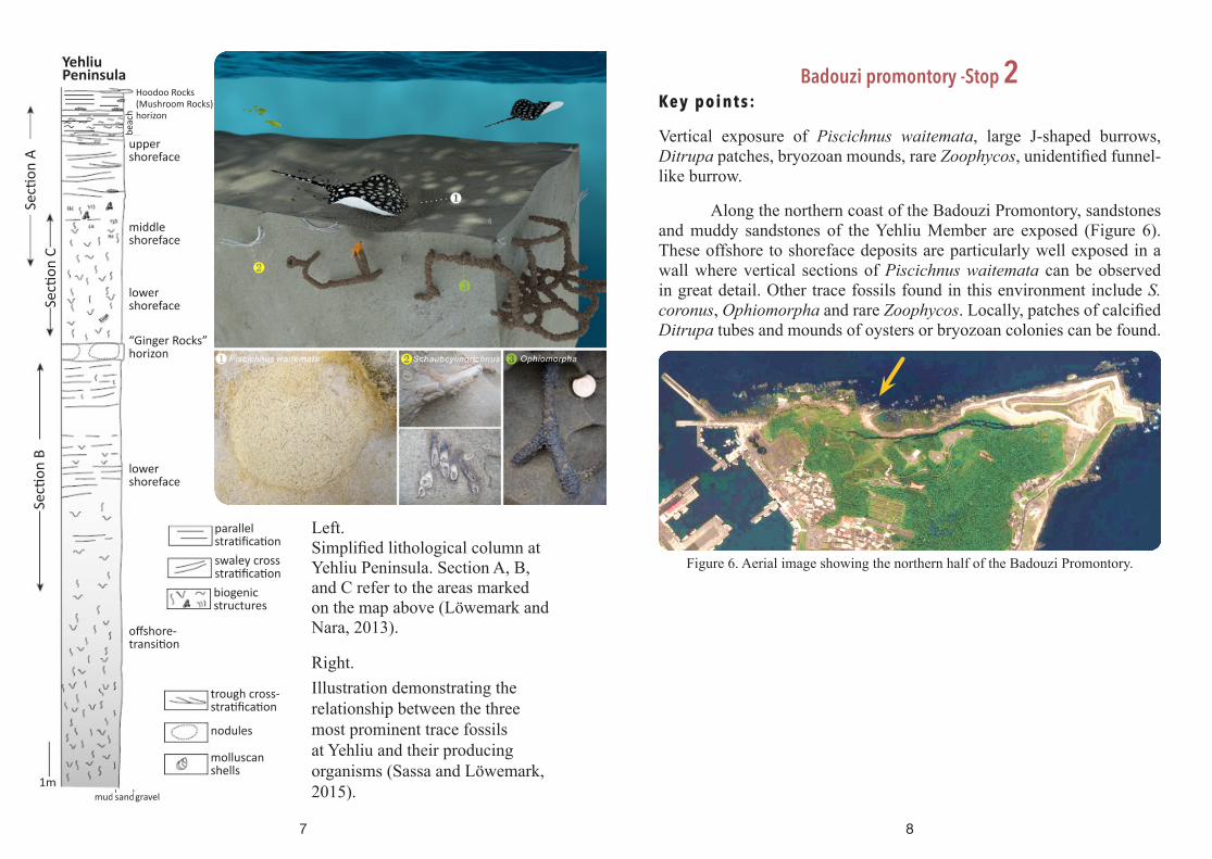
Left. Simplified lithological column at Yehliu Peninsula. Section A, B, and C refer to the areas marked on the map above (Löwemark and Nara, 2013).
Right. Illustration demonstrating the relationship between the three most prominent trace fossils at Yehliu and their producing organisms (Sassa and Löwemark, 2015).
Badouzi promontory -Stop 2Key points:
Vertical exposure of Piscichnus waitemata, large J-shaped burrows, Ditrupa patches, bryozoan mounds, rare Zoophycos, unidentified funnel-like burrow.
Along the northern coast of the Badouzi Promontory, sandstones and muddy sandstones of the Yehliu Member are exposed (Figure 6). These offshore to shoreface deposits are particularly well exposed in a wall where vertical sections of Piscichnus waitemata can be observed in great detail. Other trace fossils found in this environment include S. coronus, Ophiomorpha and rare Zoophycos. Locally, patches of calcified Ditrupa tubes and mounds of oysters or bryozoan colonies can be found.
Figure 6. Aerial image showing the northern half of the Badouzi Promontory.
Yehliu Peninsula
middle shoreface
upper shoreface
lower shoreface
lower shoreface
Secti
on B
Secti
on C
Secti
on A
beac
h
1m
offshore- transition
trough cross- stratification
biogenic structures
parallel stratificationswaley cross stratification
molluscan shells
nodules
mud sandgravel
“Ginger Rocks”horizon
Hoodoo Rocks(Mushroom Rocks)horizon

109
Within a thick massive calcareous sandstone bed, enigmatic funnel-like burrows were observed. In cross section, a shaft 2-3 cm in diameter penetrates vertically for about 1 m before gradually bending to horizontal, giving it an overall J-shaped form. Also, some feather-like structures appear around the top of the shaft, but not in the deeper parts. Detailed studies suggest that the shaft can be divided into 5 parts (Figure 8). Three competing ethological hypotheses are proposed as outlined in figure 8 below:
Figure 8. 3D structure of funnel-like burrow and three ethological hypothesesFigure 7. Detailed stratigraphic column of the Taliao Formation at Badouzi (modified from Löwemark and Hong, 2006)
Top part of huge, J-shaped tube
Lower, bending part of huge, J-shaped tube
Vertical exposure of P. waitemata
Upp
er m
embe
rinner offshore
shoreface
tidal flatShiti Fm.
Litho unit Sedimentary Environment
offshore
0m
50m
100m
150m
200m
250m
300m
350m
400m
offshore bar
inner offshore
inner offshore
Low
er m
embe
rYe
hliu
mem
ber
11 12
Nankang Formation
The traditional section of the Nankang Formation starts at Shuinandong parking lot (Stop 4) and ends at Nanyali (Huang et al., 1979; Yu, 1997). The total thickness of the formation is about 500 meters; it can be roughly divided into three parts: Sandstone with abundant sea urchin and Mollusca fossils make up the lower part, a 50 m thick shale and a 29 m thick tuff constitute the middle part, and the upper sandstone contains several beds rich in Operculina and Mollusca fossils (Huang et al., 1979). The sedimentary environment of Nankang Formation mostly fluctuates between shoreface and inner shelf, composing one and a half transgressive-regressive cycle (Figure 9) (Yu and Teng, 1999).Figure 9. Simplified stratigraphic column
of the Nankang Formation (modified from Yu and Teng, 1999).
13
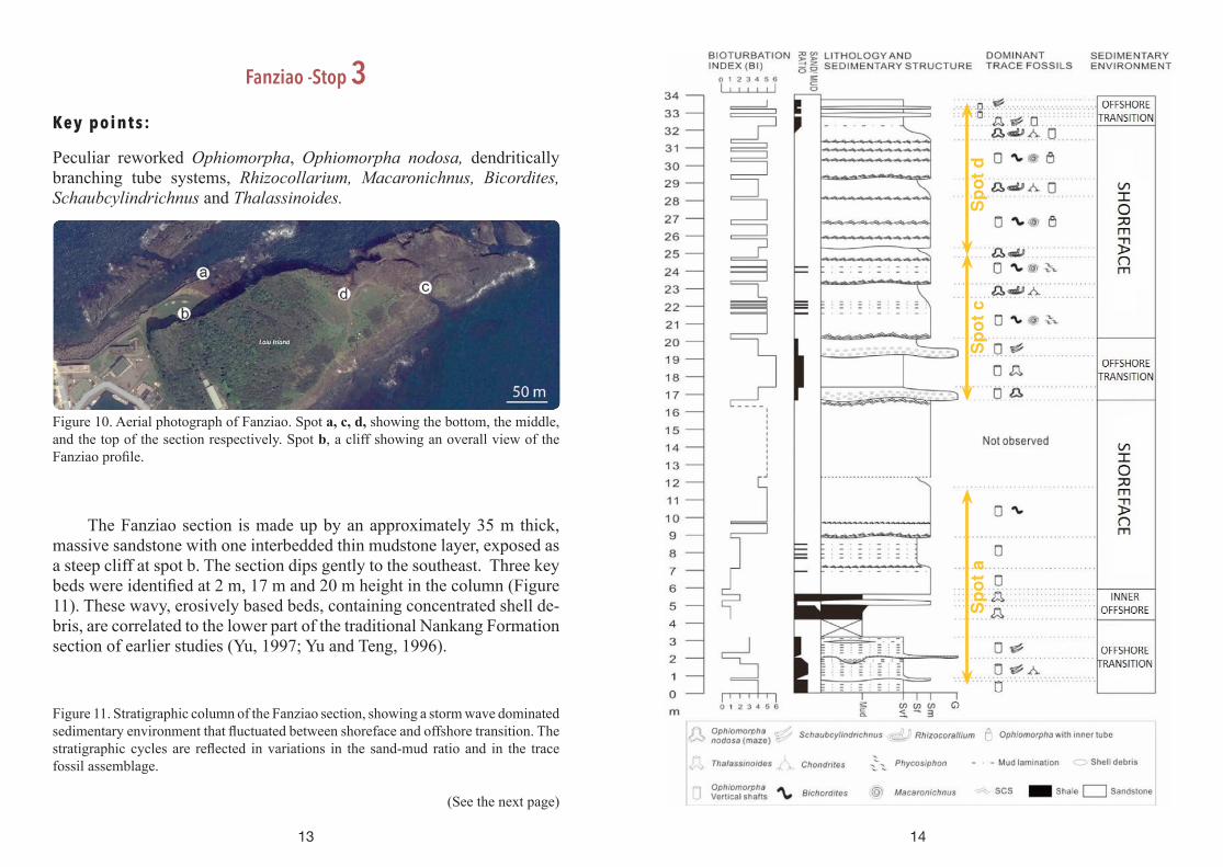
Fanziao -Stop 3 Key p oi nt s:
Peculiar reworked Ophiomorpha, Ophiomorpha nodosa, dendritically branching tube systems, Rhizocollarium, Macaronichnus, Bicordites, Schaubcylindrichnus and Thalassinoides.
Figure 10. Aerial photograph of Fanziao. Spot a, c, d, showing the bottom, the middle, and the top of the section respectively. Spot b, a cliff showing an overall view of the Fanziao profile.
The Fanziao section is made up by an approximately 35 m thick, massive sandstone with one interbedded thin mudstone layer, exposed as a steep cliff at spot b. The section dips gently to the southeast. Three key beds were identified at 2 m, 17 m and 20 m height in the column (Figure 11). These wavy, erosively based beds, containing concentrated shell de-bris, are correlated to the lower part of the traditional Nankang Formation section of earlier studies (Yu, 1997; Yu and Teng, 1996).
Figure 11. Stratigraphic column of the Fanziao section, showing a storm wave dominated sedimentary environment that fluctuated between shoreface and offshore transition. The stratigraphic cycles are reflected in variations in the sand-mud ratio and in the trace fossil assemblage.
(See the next page)
14
Spot
aSp
ot c
Spot
d

15
The thick shoreface sandstone was commonly burrowed, whereas some intercalated, unbioturbated intervals preserved sedimentary structures, including swaley, trough, and planar cross-stratification. Four distinct morphotypes of Ophiomorpha-like burrows can be distinguished in these sandstones (Figure 11). In addition, the sandstones at Fanziao contains numerous Bichordites and Macaronichnus in certain beds, and Rhizocorallium is common in the layers where O. nodosa is abundant. Chondrites and Planolites were occasionally encountered. In contrast, the bioturbation index of muddy sandstone is usually high, especially so for the muddy bed in the middle part of the section. Schaubcylindrichnus and Thalassinoides were found only within the muddy sandstones and shales. The depositional environment, therefore, is interpreted varying according to the different ichnoassemblages. Interestingly, despite the high abundance of crustacean burrows, only few stingray feeding pits (Piscichnus waitemata) were observed, in stark contrast to the underlying Taliao Formation where feeding pits of stingray were found to be targeted directly to the shafts of Ophiomorpha burrow systems (Löwemark, 2015).
Figure 12. Photographs of the four morphotypes of Ophiomorpha distinguished at Fanziao. A) Bedding plane view of Ophiomorpha nodosa which produces extensive mazes of thickly lined knobby tubes. B) Bedding plane view of the thin, straight segments with widely spaced regular branches. C) Bedding plane view of densely branching, dendritic tube systems. D) Cross-section view of L-shaped shaft with inner tube.
16
A peculiar reworked Ophiomorpha shaft (type D in Figure 12) occurs in several intervals, consisting of a lined tube that extends for a considerable vertical distance before abruptly turning horizontal, giving that tube system an overall L-shaped appearance (Figure 13). Horizontal parts are rarely observed even in areas where vertical shafts are common, suggesting that the horizontal part is short and not part of an extensive maze as in the adjacent O. nodosa. Both lining and pellets are considerably less pronounced compared to O. nodosa. The tube diameter is slightly smaller than for O. nodosa, typically ranging between 2 and 3 cm. In the vertical shafts, signs of an inner tube are common. This inner tube is lined by a thin knobby wall similar in color to the larger outer wall. A comparison of paired samples of Ophiomorpha vertical shaft diameters and the diameters of the inner tubes from the same samples reveal a weak correlation between the two. This weak correlation indicates that the size of the organism producing the inner tube is largely independent of the diameter of the vertical shafts. In a few instances, thin-walled vertical shafts with inner tubes partly overlapping or intergrading with the thick-walled tube systems of O. nodosa systems were seen. A hypothesis that the inner tubes were produced by crustacean larva was proposed by Löwemark et al. (2016). (Figure 13)

17
Figure 13. A) Cross-section view of a peculiar Ophiomorpha shaft with an inner tube. B) Model explaining the presence of reworked shafts. C) Thin section analysis com-paring components of outer and inner tube.
18
Shuinandong Harbor -Stop 4 Key points:
Echinoderm fossils, unidentified, winding backfilled trace fossils, Zoophycos-like trace fossil, enigmatic embedded boulder.
Shuinandong Harbor parking lot is the starting point of the traditional Nankang Formation. The area is characterized by abundant irregular echinoid fossils, therefore informally called the Sea urchin tomb. The entire section is visible at Spot a (Figure 14), showing a deepening upward sequence in the lower Nankang Formation. Some sedimentary structures are still visible sporadically in the lower part of the section, including planar cross-stratification, swaley cross-stratification and muddy lamination. On the other hand, in the upper part of the section where sea urchin fossils are abundant, the muddy sandstone is severely bioturbated, containing Thalassinoides, Schaubcylindrichnus, Chondrites, and Ophiomorpha mazes (Spot b, Figure 14). Most of the section was interpreted to have been deposited between fair-weather wave base and storm wave base.
Figure 14. Aerial photograph of the Sea urchin tomb with characteristic spots: a) inner offshore features, b) Quartzite boulder encased in the Nankang Formation, c) conglom-erate bed.

19
Figure 15. Two unidentified trace fossils at Spot c, Figure 13. A: Bedding plane view of unidentified backfilled burrow B: Bedding plane view of Zoophycos-like trace fossil.
Several unidentified backfilled traces (Figure 15A) can be observed at spot c (Figure 14). The trace fossil show some similaritiy to Bichordites, but the diameter of the curves are much smaller than Bicrodrites (which is also not common in this environment, but abundant in shoreface). Although these traces resemble echinoid traces, their true affinity remains obscure. Another peculiar trace fossil located at spot c (Figure 14) is somehow similar to Zoophycos with the protrusive spreite (Figure 15B). However, it is untypical for Zoophycos to be found in Miocene offshore transition sandstones, although previous studies have reported such trace fossils within the Nankang Formation.
An enigmatic quartzite boulder is encased within the sandstone, and the joint around it has been infilled with calcareous fossil fragments. Further, along the crack, an irregular shaped conglomerate bed can be seen pinching out within the sandstone (Figure 15). The grain size of the clasts in the bed is extremely varying and considerably coarser than the surrounding sedimentary environment. Also, the contact with upper and lower boundaries is enigmatic. This strange bed has not received a satisfactory explanation yet; could it be a tsunami record in the Miocene (~15 Ma)? If that is so, where did these boulders originate from, if the Penglai orogeny (about 7 Ma) hadn’t started yet?
20
Figure 16. At spot c (Figure 14) A) Quartzite boulder incased in the Nankang Formation. B) Close up look of the crack around the boulder. C) Along the crack, a conglomerate bed intercalated within severely bioturbated sandstones. D) Coral fossils mixed up in the conglomerate.
Reference
Chou, J.T., 1970. A stratigraphy and sedimentary analysis of the Miocene in northern Taiwan. Petrol. Geol. Taiwan, 7: 145-189.
Chen, W.-S., 2005. Characteristic trace fossils from shoreface to offshore environments of an Oligocene succession, Northeastern Taiwan. TAO, 16(5): 1097-1120.
Sassa Chen and Ludvig Löwemark, 2015. 中新世大寮層發現: 魟魚掠食海蛄蝦之證據. Ti-Chih, 34: 78-81.
Gregory, M.R., 1991. New trace fossils from the Miocene of Northland, New Zealand: Rorschachichnus amoeba and Piscichnus waitemata. Ichnos, 1(3): 195-205.
Ho, C.S., Hsu, M.Y., Jen, L.S. and Fong, G.S., 1964. Geology and coal resources of the northern coastal area of Taiwan. Bulletin of the Geological Survey of Taiwan, 15: 1-23.
Ho, C.S., 1986. Introduction to the geology of Taiwan: Explanatory text of the geologic map of Taiwan. Central Geologic Survey, MOEA, R.O.C., Taipei, 163 pp.
Hong, E. and Wang, Y., 1988. Basin analysis of the upper Miocene-lower Pliocene series in northwestern foothills of Taiwan. Ti-Chih, 8(1-2): 1-20.
Hong, E. and Huang, E., 2000. The formation of the pedestal rocks in the Taliao Formation, northern coast of Taiwan. Journal of the Geolological Society of China, 44(1): 43-72.
Hong, E. and Huang, E., 2001. Formation of the pedestal rocks in the Taliao Formation, northeastern coast of Taiwan. Western Pacific Earth Sciences, 1(1): 99-106.
Huang, C.Y., 1990. Upper Miocene stratigraphy and the horizon of post- Lushanian fauna turnover in Northeastern Taiwan. Proceedings of the Geological Society of China, 33(4): 303-328.

21
Huang, C.Y., Cheng, Y.M. and Huang, T., 1979. Preliminary biostratigraphic study of the Nankang Formation in the Shuinantung section, northern Taiwan. Ti-Chih (In Chinese), 2: 1-11.
Löwemark, L. and Hong, E., 2006. Schaubcylindrichnus formosus isp. nov. in Miocene sandstones from northeastern Taiwan. Ichnos, 13(4): 267-276.
Löwemark, L. and Nara, M., 2013. Morphological variability of the trace fossil Schaubcylindrichnus coronus as a response to environmental forcing. Palaeontologica Electronica, 16(1): 5A 14p.
Löwemark, L., 2015. Evidence for targeted elasmobranch predation on thalassinidean shrimp in the Miocene Taliao sandstone formation, NE Taiwan. Lethaia. DOI 10.1111/let.12101
Löwemark, L., Zheng, Y. C., Das, Subarna, Chen, T. T., Yeh, C. P., 2016. A peculiar reworking of Ophiomorpha shafts in the Miocene Nangang Formation, Taiwan, Geodinamica Acta, 28(1-2), 71-85.
Seike, K., 2007. Palaeoenvironmental and palaeogeographical implications of modern Macaronichnus segregatis-like traces in foreshore sediments on the Pacific coast of central Japan. Palaeogeogr., Palaeoclim., Palaeoec., 252(3-4): 497-502.
Shyu, J.B.H., Sieh, K., Chen, Y.-G. and Liu, C.-S., 2005. Neotectonic architecture of Taiwan and its implications for future large earthquakes. Journal of Geophysical Research: Solid Earth, 110(B8): B08402. 10.1029/2004JB003251
Suppe, J., 1984. Kinematics of arc-continent collision, flipping of subduction, and back-arc spreading near Taiwan. Memoir of the Geological Society of China, 6: 21-33.
Teng, L.S., Wang, Y., Tang, C.H., Huang, T.C., Yu, M.S. and Ke, A., 1991. Tectonic aspects of the Paleogene depositional basin of northern Taiwan. Proceedings of the Geological Society of China, 34: 313-316.
Yen, T.P. and Chen, P.Y., 1953. Explanatory Text of the Geologic Map of Taiwan, Tatunshan Sheet. Geological Survey of Taiwan, 9 pp.
Yu, N.T. and Teng, S.L., 1996. Facies characteristics and depositional cycles of middle and upper Miocene strata of the Western Foothills, northern Taiwan. Ti-Chih, 15: 29-60.
Yu, N.T., 1997. Sequence stratigraphy of the middle to upper Miocene strata, northern Taiwan: a preliminary study. Proceedings of the Geological Society of China, 40: 685-707.
Yu, N.T. and Teng, L.S., 1999. Depositional environments of the Taliao and Shihti Formations, northern Taiwan. Bulletin of the Central Geological Survey, Taiwan, 12: 99-132.
This field guide incorporates text and figures from the following publications:
Löwemark, L., 2015. Evidence for targeted elasmobranch predation on thalassinidean shrimp in the Miocene Taliao sandstone formation, NE Taiwan. Lethaia, 48, 227-234.
Löwemark, L. and Hong, E., 2006. Schaubcylindrichnus formosus isp. nov. in Miocene sandstones from northeastern Taiwan. Ichnos, 13(4), 267-276.
Löwemark, L. and Nara, M., 2010. Morphology, ethology and taxonomy of the ichnogenus Schaubcylindrichnus: Notes for clarification. Palaeogeography, Palaeoclimatology, Palaeoecology, 297(1), 184-187.
Löwemark, L. and Nara, M., 2013. Morphological variability of the trace fossil Schaubcylindrichnus coronus as a response to environmental forcing. Palaeontologica electronica, 16(1), 5A 14p.
Löwemark, L., Zheng, Y.-C., Das, S., Yeh, C.-P. and Chen, T.-T., 2016. A peculiar reworking of Ophiomorpha shafts in the Miocene Nangang Formation, Taiwan. Geodinamica acta, 28(1-2), 71-85.
(Compiled by Charlie Zheng, Chung-Ping Yeh, Yu-Yen Pan, Ludvig Löwemark, Pei-Chen Kuo, Sassa Chen, Weng-Si Chao)
22
X
Analytical Systems
X
Analytical Systems
IIWXIV would like to thank our SPONSORS