tamaya astro-navigation piloting & dead reckoning (for nc-77)
TRANSCRIPT

ASTRO~NAVIGATION
PILOTING
!---__--"'l~_f &..DEAD RECKONING

Semidiameter (S.O,) of the Sun and Horizontal Parallax(H.P.) of Venus and Mars.
For Sextant Altitude corrections
SIMPLEmERIOUS
t::::)1C3IT~L
p
S.D. Sun @
January 16:3 July 15.8
February 16.2 August 15.8
March 16.1 September 15.9
April 16.0 October 16.1
M'Y15.9 November 16.2
June 15.8 December 16.3
H. Mars1978 Jan. 1 _Mar. 10 0~2 10S0T" 1 - Ap,. 0 0:1
Mar. 20 Dec. 31 0.1 Apr.7 - May 25 0.2
1979 Jan. 1 Dac. 31 10.2 May 26 - Jul. 2 0.3
1980 Jan. 1 Apr. 2. 0.2 'Jul. 3 - Jul. 31 0.4
Apr. 26 - Dec. 31 0.1 Aug. 1 -Sep.12 0.3
Dec:..!!-~Sap, 13 -Nov,13 0.2
1981 Jan. 1 Nov. 14 - Dec, 31 0.11982 Jan, 1 Feb,2 0.1 Dec. 31 0.1
Feb,3 _Jun.15 0.2 1987 Jan. 1
IJun . 16 Dec.31 0.1 1988 Jan. 1 May 22 0.1
1983 Jan. 1 Dec. 31 0.1 May 23 - Jul. 24 0.2
1984 Jan. 1 Mar.4 0.1Jul. 25 - Sep. 2 0.3
Mar.5 - Aug. 27 0.2 Sep.3 - Oct. 10 0.4
Aug. 28 Dec. 31 0.1 Oct. 11 - Nov. 1'3 0.3Nov. 14 Dec. 31 0.2
1985 Jan. 1 Dec. 31 0.119891 Jan . 1 0.2
! Jan. 2 - Dec. 31 0.1
BY TAMAYA DIGITAL NAVIGATION COMPUTER NC·nTABLE 1
H P Venus --9-1978 Jan. 1 Jul.23 0:1 1984 Jan. 1 Dec, 13 0:1
Jul.24 _Sep.l0 0.2 Dec. 14 - Dec. 31 0.2
Sep. 11 -Oct.3 0.3 1985 Jan. 1 _ Feb. 4 0.2
Oct. 4 _Oct.19 0.4 Feb. 5 _ Feb. 28 0.3
Oct. 20 - Nov, 29 0.' Mar. 1 _ Mar. 17 0.4
Nov. 30 - Dec. 14 0.4 Mar. 18_Apr. 21 O.Dec. 15 - Dec. 31 0.3 Apr. 22-May 7 0.4
1979 Jan. 1 Jan.6 0.3 May 8 - May 29 0.3
Jan.7 - Feb. 27 0.2 \May 30-Jul.17 0.2
Feb. 28 _. Dec. 31 0.1 Jul. 18 - Dec. 31 0.1
1980 Jan. 1 - Mar. 1 0.1 1986 Jan. 1 Jul. 20 0.1
Mar. 2 - Apr. 21 0.2 Jul. 21 -Sep.8 0.2
Apr. 22 - May 14 0.3 Sep.9 -Oct.1 0.3
May 15 - May 30 0.4 Oct. 2 -Oct.16 0.4
May 31 _ Jul. 1 0.' Oct. 17-Nov.26 O.
Jul. 2 _Jut. 17 10.4 Nov. 27- Dec. 12 0.4
Jul. 18 _ Aug. 9 0.3 Dec. 13- Dec. 31 0.3
Aug.l0-Sep.29 0.2 1987 Jan. 1 Jan.4 0.3
Sep.30 - Dec. 31 0.1 Jan.5 _ Feb. 25 0.2
1981 Jan. 1 Nov. 21 0.2 Feb. 26 Dec. 31, 0.1
Nov. 22 - Dec. 15 0.3 1988 Jan. 1 Feb, 27 0.1Dec. 16 - Dec. 30 0.4 Feb. 28 -A?r.19 0.2Dec. 31 a.' APr. 20 -May 11 0.3
1982 Jan. 1 feb. 10 a.' May 12 -May 28 0.4
Feb. 11 - Feb. 25 0.4 MlilY 29 -Jun. 28 a.'Feb. 26 - Mar. 20 0.3 Jun. 29 -Jul. 15 0.4
IMar. 1-May9 0.2 Jul. 16 -Aug. 6 0.3
May 10 Dec. 31 0.1 Aug. 7 -Sep.27 0.2
1983 Jiln.1 - May 13 0.1 Sep.28 -Dec. 31 0.1
May 14 _ Jul. 1 0.2 1989 Jan. 1 Sep. 28 0.1Jul. 2 - Jul. 23 0.3 Sep. 29 -Nov. 19 0.2Jul. 24 _ Aug. 8 0.4 Nov. 20 -Dee. 12 0.3Aug.9 _Sep.l1 0.' Dec. 13 -Dec. 28 0.4Sap. 12 _ Sep. 28 0.4 Dec. 29 -Dec. 31 0.'Sep.29 _ Oct. 21 0.3Oct.:;1:2 _ Dec. 13,0.2Dec. 14·_ Dec. 31: 0.1

Contents Introduction
ASTRO-NAVIGATION BY NC-77
Plane Sailing and Navigationthrough Current and Wind 42
Tide and Stream {Tidal Current} 46
Fundamentals of Astra-Navigation 4
Taking Sight with a Sextant . . . . . . . . 8
Finding the Geographical Positionof Heavenly Bodies(Greenwich Hour Angle and Declination) 10
Computation <lnd Plotting for Fix 15
Sextant Altitude Corrections 24
Identification of Unknown Star. . . . . . . . .. 32
Fix by Noon Sight and OtherSextant Applications. . . . . . . . . . . . . . . .. 34
BASIC NAVIGATION COMPUTATIONSFOR DEAD RECKONING AND PILOTINGBY NC-77
Introduction
PART ONE:
CHAPTER I
CHAPTER II
CHAPTER III
CHAPTER IV
CHAPTER V
CHAPTER VI
CHAPTER VII
PART TWO:
CHAPTER I
CHAPTER II
CHAPTER III
Mercator Sailing andGreat Circle Sailing .. ............ 38
With TAMAYA NC-77 DIGITAL NAVIGATION COMPUTERwe can digitally solve most navigational problems with scientificaccuracy and incredible speed in a very easy way. However, it is afallacy to believe that computers will do everything for us. Safetyat sea always depends on our sound judgement, whatever tools wemay use to facilitate our work. For this reason, this textbook notonly explains how to use NC-77 Computer but also refers to theprinciples and fundamentals of navigation.
In PART ONE determining our position by Astro-Navigationis expounded fully from the principle to the actual steps of computation. In PART TWO Basic Navigation Computations for DeadReckoning and Piloting are explained with examples and illustrations. The text is very easy, and no special knowledge of computerprogramming or mathematics is required.
In the course of learning in this textbook, if any question arisesabout the meaning of keys and dialogue symbols of NC~77 we canrefer to the Appendix where full explanation is given with illustra~
tions.For further study on navigation, it is recommended to read such
classical textbooks as ..American Practical Navigator" by Bowditchor "Dutton's Navigation and Piloting" by Dunlop and Shufeldt,with NC-77 computer at hand. Comprehension of these textbooksis greatly advanced because with NC-77 we can save a lot of timeotherwise spent unnecessarily on acquiring techniques on mechanical computations. Consequently. we can concentrate on understanding of more important fundamentals and principles of navigation.
CHAPTE R IV Speed, Time, Distance ,. 48
CHAPTER V Time and Arc 49
APPENDIX
2
EXPLANATION OF NC·77 DIGITALNAVIGATION COMPUTER , .. ,. 50
3

INow, if we drew a position circle with a radius of 3,000 miles
and the ~P as center, our ship must be somewhere on it. See Fig.4.By drawmg anot~er position circle with another heavenly bodywh~~e GP an~ ~Istance are known we can determine our ship'sposition at their Intersection.
The next thing we must know is the distance from our ship tothe GP. It can be determined by measuring the altitude of theheavenly bod~ above the horizon. For instance, if we observed a~tar at the altitude of 40 degrees we can figure out the distance toIts GP as 3,000 miles by computation. [The distance from our shipto the. GP of a he.ave.nly body = (90' - altitude) x 60 mile.s] .See Fig. 3, and supplementary note on page 33.
Fig.3 Distance. from ship to GP of star ~¥-
/ 5;'
~ 90/Gp
'- ._--3000 miles-__
1. PRINCIPLE OF ASTRO·NAVIGATION
When we know the distance from two points, the positions ofwhich are already known, we can determine our ship's position.Suppose the distance from our ship is 6 miles to Lighthouse A and8 miles to Lighthouse 8. Draw a circle with a radius of 6 miles andA as center. This is called a Position Circle because our ship mustbe somewhere on it. Now, draw another position circle with aradius of 8 miles and B as center. ObViously, the intersection ofthe two position circles is our ship's position. See Fig. 1.
~~~Lighthouse B
o Lighthouse Ao 8mil~
6 mHos \J!
Fundamentals of Astra-NavigationCHAPTER_I
PART ONE ASTRO-NAVIGATION BY NC-77
Position Line
Position Circle
Position Circle and Position Line
¥-, A'\, Zimuth of the sighted body from our ship
\ _Position Circle
,,,\ ,,,,,,
5
Fig. 4 Position Circle
~i~ce i~ is not feasible, in practice, to draw a 3,000 miles radiusPOsl.tlon ~Ircl.e on a chart, only a necessary part of it is drawn as astra.lg.ht line 10 the manner explained in Chapter IV. This is calledPOSition Line or Une of Position. See Fig. 5.
The principle of modern Astro-Navigation is just this simple.
-
Fig. 1 Finding Ship's Position by Measuring Distance
*
Fig.2 GP of a heavenly body
In Astra-Navigation, the same principle, pOSition circle method,is used to determine the ship's position. Therefore, we must always have at least two known points, and instead of lighthouses weuse heavenly bodies; the Su n, Moon, planets and stars.
The.n, how do we know the. position of any of these he.ave.nlybodies? We will express their position in terms of their Geograph~
ical Position (GP). GP is the point where a line, drawn from centerof the heavenly body to the center of the earth, would touch theearth's surface. In other words, if a star fell down directly towardthe center of the earth, the spot that it would hit on the earth'ssurface is its GP, and at this point we would see the star directlyoverhead.
4

2. BASIC STEPS AND TOOLS FOR ASTRO·NAVIGATION
It takes some steps and tools to determine our ship's position by Astro-Naviga ion as summarized in Fig. 6.Fig. 6
1. TAKING SIGHT WITH ASEXTANT.
Measure the altitude of theheavenly body (Sun, Moon,planet or star) above the hori·zon at your position.Record the exact GreenwichMean Time (GMT) of the sight.
/11l I
I!I'
I!II/ i, '
!
• Sextant • Quartz Watch
2. FINOING GEOGRAPH·ICAL POSITION (GP) OFTHE SIGHTEO BODY:
The GP is the point on the earthdirectly beneath the heavenlybody, and it is expressed byGreenwich Hour Angle (GHA)and Declination (DEC), Theyare computed by Ne-n orfound in the Nautical Almanac. DEC N20
0
GHA 1200
3. COMPUTATION BY NC-77AND PLOTTING:
Compute the Azimuth C=-) and Altitude (R) ofthe same body by Ne-n using the factorsfound in Steps (1) and {21, and the DR posi·tion. (A ship's position determined by applyingthe cource and distance travelled from someknown position, e,g., the departing port, iscalled Dead Reckoning Position.) Compare thecomputed Altitude (R l with the ac:wallyobserved True Altitude (Ral. From the abovefactors we can plot a line of position (LOP) onthe chart or plotting sheet. Plot two LOP's todetermine our ship's position at their intersection (FIX), or compute it digitally by Nc-n.
6
GreenwicrLine
~~~~~DR Lat 30° N
DR Long 600
\
(~.. ,.... ".'1 u' '-"'~ -','
'..... .><>DR0 ", 0 ":"
Y C'092~~ _
".. .&'1- .
\0
»
• NC·77 Computer
• Plotting Instruments
TOOLS,
or
• Nautical Almanac
• NC·77 Computer
7

MSUN
In a high quality sextant the altitude can be read by degrees,minutes and 1/10 minute. One minute of the sextant reading isequivalent to one nautical mile.
w-'oz~
:r Horizon mirror~
Z
~t-------Xw~
Fig. 8
Index Mirror
Horizon
Reflected image of the Sun
2. UUARTZ WATCH
In Astra-Navigation it is necessary to read hours, minutes, andseconds of time, so the digital quartz watch having the seconds display is very convenient for such reading of accurate time. Fourseconds of time is equivalent to one minute of longitude (one nautical mile at latitude 0°).
When a sight is taken, record the altitude of the body measuredby the sextant and the exact Greenwich Mean Time (GMT) of thesight. Greenwich Mean Time is the time at longirude 0°. LocalMean Time (LMT) will depart 1 hour from GMT for every 15° oflongitude. Therefore, Zone Time in New York, based on LMT at?5°W long., is 5 hours before GMT, and Zone Time in San Francisco based on LMT at 120
0W long. is 8 hours before GMT. If we
go eastward, Tokyo based on LMT at 135° E long. is 9 hours afterGMT. With this principle in mind, LMT can be easily converted toGMT.
Horizon -'---------
Taking Sight with a Sextant
/!
1. SEXTANT
Taking a sight means to measure the vertical angle or altitudebetween a heavenly body and the horizon in order to ascertain ~he
ship's position at sea. The sextant is used as a tool to accomplish
this aim.All marine sextants have two mirros arranged as shown in Fig. 7
and work on the same principle. The index mirror reflects theimage of the body to the horizon mirror. The horizon mirror is soconstracted that one can see the horizon at the same time he seesthe reflected image of the whole body. Thus, the altitude of thebody is measured by adjusting the angle of the index mirror untilthe reflected image contacts the horizon (Fig. 8).
CHAPTER II
Sextant arc and reading
Fig. 7
8 9
= D

CHAPTER III
Finding The Geographical Position ofHeavenly Bodies(Greenwich Hour Angle and Declination)
Problem 2. Find the GHA and DEC of the Moon at GMT 05h25
m18
son Jan. 1, 1978. We need Nautical Alma
nac to find GHA and DEC of the Moon, planets andstars. NC-77 greatly facilitates the procedure ofderiving the required information from the NauticalAlmanac. Nautical Almanac is published every yearby the U.S. Naval observatory or equivalent authorities in other countries.
The Geographical Position is the point on the earth directly beneath the heavenly body, and it is expressed in terms of GreenwichHour Angle (GHA) and Declination IDEC). GHA and DEC are likelongitude and latitude that are used to designate positions on theearth. In Astro-Navigationwe use the Sun, Moon, Venus, Mars,Jupiter, Saturn and selected navigational stars as reference bodies.We can obtain GHA and DEC of the Sun by NC-77 Aimanac~ mode. For the other bodies we use NC-77 and the Nautical
Almanac. Let us work on examples.
Problem 1. Find the GHA and DEC of the Sun at GMT14h 35m 43s on Jan. 1,1978 by NC-77.
Key Display Note:
8 , o. Year Month Day78.0101 " 78.0101 78 01 01@J h O.
14.3543 h 14.3543 Hour Minute Second14 35 43
@j Ho 319.492 GHA Aries
@ d -22.599 DEC Sun
@j H 38.025 GHA Sun
@ to -0.0333 Equation of Time@) Repeat d and H
Answer: GHA Sun (Dialogue Symbol : H) 38°02'.5DEC Sun (Dialogue Symbol : d I S22° 59'.9
We will make use of GHA Aries (Ho ) later inthe star problem, and Equation of Time (1::0)in the noon sight problem.
GHA/DEC ys. Longitude/Latitude
DEC is measured like latitude f from the equ~"or to 90° north and90
0south. It should be noted that GHA and longitude are not
expressed exactly the same. Whereas longitude is measured fromthe Greenwich meridian (longitude 0° line) to 1800 east and to180° west. GHA is measured only westward up to 3600 from it.Therefore, longitude 90° east, for instance, is equivalent to GHA270'.
10
-
As an example, we will find the following data in the 1978 Nautical .A:lmanac for Sunday, January 1. See Table 2 - Excerpt fromNautical Almanac.
MOON STARSG.M.T.
G.H.A. Dec H,P. Nome S.H.A. D"
i 00I 288 01.3 N 1 38.0 Acamar ' "56.3 315 38.4 540 2.3.801 302 33.5 1 27.9 56.3 Achernor 335 46.6 557 21.202
1
317 05.7 1 17.8 56.3 Acrux 173 39.1 562 58,403 331 37.8 1 07.7 56,4 Adhero 255 33.1 528 56.704 346 10.0 o 57.5 56.4 Aldebaran 291 19.8 N16 27.905, o 42.1 o 47.4 56.406 i 15 14.1 N 0 37.2 56.4 Aliofh 166 44.2 N56 04.5071 29 46.2 o 27.0 565 Alkoid 153 20.2 N49 25.108 i 44 18.2 o 16.8 56.5 Al No'ir 28 17.6 547 04.2S 09
1
58 50.2 N 0 06.6 56.5 Alnilam 276 13.2 S 1 D.1U
i~I 73 22.1 5 0 03.6 56.6 Al'phord 218 22.1 5 8 33.9N 87 54.0 o 13.8 56.60 12 102 25.9 5 0 24.0 56.6 Alphecca 126 33.9 N26 47.3A 13 , 116 57.8 o 34..3 56.7 Alpheratz 358 11.2 N28 58.3y 14
1131 29.6 o 44.5 56.7 Altair 62 34.6 N 8 48.715 146 01.4 o 54.8 56.7 Ankaa 353 42.1 542 25.816 ' 160 33.1 1 05.0 56.8 Antares 112 59.4 526 22.917 175 04.8 1 15.3 56.8
18 189 36.5 1 25.6 56.8 Arcturus 146 20.3 N19 17.719 204 08.1 1 35.9 569 Atria 108 25.7 568 59,120 218 39.7 1 46.2 56.9 Avior 234 28.3 559 26.321 233 11.2 1 56.5 56.9 Bellafri;.:: 279 00.4 N 6 19.722 247 42.7 2 06.7 57.0 Betelgeuse 271 29.9 N 7 24.123 262 14.2 2 17.0 57.0
Canopus 264 07,4 552 41.Capello 281 13.5 N
TABLE 2
(Continue to page 12)
11

In order to find the GHA and DEC of the Moon at GMT 05h25m_18
5, w~ first find the data for GMT 05h and 06h, and feed them to
NC-77 In the following manner.
DEC NO'43'.1
GHAProblem 2
Answer
DECMoon K.y Display Key DisplayGMT GHA DEC 0~ h o. CD@ h05 h 0
042',1 NO
o47'.4
O.5 h 5. 5 h 5.06 15 14,1 NO 37.2 @ d O. @) d O.0,421 d 0.421 0.474 d 0.474@ h O. @) h O.From Nautical Almanac 6 h 6. 6 h 6.(Table 2) @) d o. @ d O.15.141 d 15.141 0.372 d 0.372@ h' O. @ h' O.5.2518 h' 5.2518 5.2518 ·h' 5.2518@ d' 6.498 @ d' 0.431
SUN ARIES VENUSG.M.T.
G.H.A. G.HA 0"G.H.A. Dec.
0 " o , 0 o , 0
100 179 10.8 523 02.8 100 17.5 184 41.5 523 38.201 194 10.5 02.0 115 20.0 199 40.5 38102 209 10.2 02.4 130 22.4 214 39.5 38.103 224 09.9 .. 022 145 24.9 229 38.5 .. 38.104 239 09.0 02.0 160 27.4 244 37.6 38.105 254 09.4 01.8 175 29.8 259 30.0 38.0
06 269 09.1 523 016 190 32.3 274 35.6 523 38.007 284 08.8 01.4 205 34.8 289 34,7 38.008 299 08.5 OL2 220 37.2 304 33.7 37.9
5 09 314 08.2 .. 01.0 235 39.7 319 32,7 .. 37.9
U 10 329 07.9 00.8 250 42,2 33431.7 37,9
N 11 344 07.6 00.6 265 44.6 349 30.8 37.80 12 359 07.3 523 00.4 28047.1 4 29.8523 37.8A 13 14 07.0 00.2 295 49.5 19 28.8 37.7y 14 29 06.7 23 00.0 310 52.0 34 27.9 37.7
15 44 06.4 22 59.8 325 54,5 49 26,9 .. 37.716 59 06.1 59.6 340 56.9 64 25.9 37.617 74 05.8 59,3 355 59.4 79 24,9 37.018 89 055 522 59.1 11 01.9 94 24.0 523 37.519 104 05.2 58.9 26 04,3 109 23.0 37.520 119 04,9 58.7 41 06.8 124 22.0 37.421 134 04.6 .. 58.5 56 09.3 139 21.1 .. 37.422 149 04.3 58.3 71 11.7 154 20.1 37.323 164 04.0 58.1 86 14.2 169 19.1 37.3
MARS JUPITER SATURN
Problem 3. Find the GHA and DEC of Venu, at GMT 14h45m.52' on Jan. 1, 1978.
G.M,T ·I-"O=--.H=--.A-.--C:O-,,-.-f---:G:-.:cH-:A-.----,;OCC,,=--.-+'O".H'.A'.--O".::,-.-t
~or other plants, Mars, Jupiter and Saturn, GHA and DEC are foundIn the same manner.
Problem 3 GHA DECVenus Key Display Key DisplayGMT GHA DEC CD@ h O. Interpolation is unneCeSsary14h 34° 27.9 523°37.7 14 h 14. as DEC in this case does not:15 49 26.9 523 37.7 @ d O. change during one hour.
34.279 d 34.279@) h O.15 h 15.
From Nautical Almanac @ d O.(Table 2) 49.269 d 49.269
@) h' O.14.4552 h' 14.4552@) d' 45.551
d hOI 0
1 00 327 42.0 N21 43.301 342 45.7 43.502 357 48.8 43.803 12 51.9 .. 44.104 27 55.0 44.405 42 58.2 44.606 58 01.3 N21 44.9071 73 04.4 45.208 88 07.5 45.4
5 09. 103 10.0 .. 45.7U 10 118 13.7 46.0
IN~ 11 133 16.9 46.2
12 148 20.0 N21 46.513 163 23.1 46814 178 26.2 47.115 193 29.4 .. 47.316 208 32.5 47.617 223 35.6 47.918 238 38.7 N21 48.219 253 41.9 48.420 268 45.0 48.721 2~3 48.1 .. 49.022 298 5Ll 49.323 313 54.4 49.5
10 26.2 N23 12.3 307 32.1 N12 44.625 29.0 12.3 322 34.7 44.640 31.9 12.3 337 37.2 44.755 34.7 .. 12.3 352 39.8 .. 44.770 37.5 12.3 7 42.3 44.885 40.3 12.3 22 44.9 44.8
100 43.1 N23 12.3 37 47.4 N12 44.9115 40.0 12.3 52 50.0 44.9130 48.8 12.3 67 52.5 44.9145 51.6 .. 12.3 82 55.1 .. 45.0160 54.4 12.3 97 57.6 45.0175 57.2 12.3 113 00.2 45.1191 00.1 N13 12.) 128 02.7 N12 45.1206 02.9 12.4 143 05.3 45.1221 05.7 12.4 158 07.8 45.22'36 08.5 12.4 173 IDA .. 45.2251 11.3 12.4 188 12.9 45.3266 142 1141 '03 155 453281' 170 N23 124 218 180 N12 454296 19 8 12.4 233 206 454311 226 121[248 231 454316 25 4 .. 12 4 263 15.7 .. 45.5341 283 124 278 282 455356 311 12 4 293 308 45 6
Answer GHA 45'55'.1 DEC 523'37'.7
--12
TABLE 2
- 13

GHA Aries is a reference meridian for establishing celestiallongitude of Stars, It is constantly changing, an.d expressed in ~ermsof westward angle from the Greenwich meridian. SHA Star IS thewestward distance of the particular star from this meridian. So, the
rule to compute GHA star is:
Greenwich Merid"lan
Probelm 4. Find the GHA and DEC of Arcturus at16h 16m39s on Jan. 1, 1978.GHA of the Star, Arcturus, is found by addingSHA of Arcturus (Sidereal Hour Angle) to the
GHA Aries.
CHAPTER IV
Computation and Plotting for FixNow we are ready to compute and plot our position. As men
tioned in the Principle of Astra-Navigation, it is impractical to drawa position circle with radius of hundreds or thousands miles on thechart. So, we plot only a necessary part of the position circle as astraight line, and call it a Line of Position (LOP).
LOP is obtained by comparing the computed altitude and theactually observed true altitude. The former is the altitude com·puted on the assumption that our 0 R is correct, and the latter isthe altitude measured by sextant at the actual position. (True Alti·tude is obtained by adding corrections to the direct sextant read·ing. See Chapter V Sextant Altitude Corrections.)
If there is a difference between the two altitudes the assumptionwas wrong by the amount of the difference IAltitude Intercept).So, we will correct our DR position so that there will be no difference between the two altitudes. [t is best to follow the actual stepsto understand this principle.
'1.
'2.1. COMPUTATION OF ALTITUDE ( ,q) AND AZIMUTH (= )
BY NC-77
A convenient NC-77 LOP COMPUTATION CARD has beenprepared to assure the proper order of input data. See the enclosedcard and Table 3.
Enter the date, GMT, name of body, DR Lat. and DR Long. inthe blanks so designated. The GHA and DEC at GMT 14h35m43s
on Jan. 1, 1978 have been obtained in Chapter III Problem (1) as38'02'.5 and 522'59'.9. Fill in the appropriate blanks with thesedata. Then, follow the steps shown on page 16.
GHA Star = GHA Aries + SHA Star.
GHA Aries is computed by NC-77 B mode, and SHA'sof fifty-seven navigational stars are found in Nautical Almanac,
Key Display
8 78.0101 ~ 78.0101 date
@ 16.1639 h 16.1639 GMT
@ He 345.074 GHA Aries
G 146.203 He 146.203 SHA Arcturus * 1
@ He 491.277 GHA Arcturus
G 360 @ He 131.277 '2
SHA Arcturus is found "In Nautical Almanac. See Table 2.
When GHA becomes greater than 360° we customarily subtract 360° to express it within one round o~ the earth. If qHAbecomes negative it is also common practice to add 360 to
express it as a positive value.
DEC of Arcturus is found in Nautical Almanac. (See Table 2) asN19° 17:7. It does not change for the whole day.
Answer: GHA 131'27:7 DEC N19'17:7
Problem 1 The DR position of a vessel is 300 22'.8N69°35'.5Wat GMT 14h35m43s on Jan. 1, 1978. The lowerlimb of the Sun is sighted by the sextant at this..
monent, and the true altitude (RD) after sextantaltitude corrections is 28°32:6.
Required: (l) Compute the Altitude and Azimuthof the Sun.
(2) Compute Altitude Intercept.(3) Piot the Line of Position.14) Obtain "FIX" by two Lines of Posi
tion.
14
•15

"1 GHA and LHA:When continuing directly to ~ mode from ~ mode do notconfuse Hand LH. H stands for Greenwich Hour Angle (GHA)and LH for Local Hour Angle {LHA). LHA = GHA ± DRLongitude. Since ~ key changes the sign to ~egative thisrule is automatically observed if we always add longitude.This computation may be made in either 8 or ~ mod~,but the dialogue symbol does not change from H to LH until~ mode key is pressed.
*2 Some navigators are accustomed oto expressing ~HA al~ays a.=a positive vaiue by applying 360 : LHA = 360 - 31 33:0328°27'.0. In such a case we may enter LHA 328°27'.0 insteadof -31°33'.0. The end result is the same.
Key.
f0E)
38.025o 69.355!fJ@]@)
22.599 !fJ@)
30.228lW@)
@)
Display
LH O.LH 38.025LH -69.355LH -31.330d O.d -22.599L O.
L 30.228R 28.378_ 146.431
Answer
\
Computed Altitude 28°37~8
Azimuth 146°43~1 T
*1 (measured clockwise
*2 ' from north 1
( Rand =can be repeated by @key)
NFig.9Spherical Triangle
sMathematics for Altitude and Azimuth Computation
The spherical triangle as formed on Fig. 9 is solved by the following equations to obtain computed Altitude ( ,q ) and Azimuth ( z:Ne-77 symboL,)
A =: sin- 1 [cos h·cosd"cosL + sind"sinL ]_'[ sind -sinA"sinL
Z = cos cosA .cosL
Where d: declination A: Computed AltitudeL: DR Lat. Z: Computed Azimuthh: LHA lobtained by GHA ± DR Long.)
Since these equations are programmed in the NC-77~ mode Aand Z are computed simply by feeding d, Land h.
2. COMPUTATION OF ALTITUOE INTERCEPT
The intercept is simply the difference between the observed truealtitude ( Ro ) and the computed altitude ( R ). The observed truealtitude is obtained by adding corrections to the direct sextantreading. These altitude corrections, consisting of multiple factors,are easily computed by NC-77, and are explained separately inCHAPTER V Sextant Altitude Corrections (See problem 1 onpage27).
For ~urposes of this problem, just take 2S03t6,as the ~bs;rved
true altitude, and the Intercept IRa - R ) ; 128 32.6 - 28 37.8); -5:215.2 milesl.
16
p
17

Display
~ 78.0101h 14.3643Ho 319.492d - 22.599H 38.025H -69.355 "1H -31.330"2
LH 31.330d - 22.599L 30.228R 28.378
146,431
For ., and *2 see page 16
Display
@11@JeD(§)@30.228 ®@@
Key
LHA Continued from aboveDEC Recall Memory 1DR LAT Chapter IV Problem (1)
ComputedAltitude Computed by NC·77True Al;muth Computed by NC·77
Jan. 1, 1978 Chapter 111 Problem OJ 878.0101GMT 14h3Sm43s Chapter III Problem (1) @l14.3543GHA ARIES 319°49',2 Computed by Ne-n @}DEC 0522°59'.9 Computed by Ne·n @) ~GHA 0 3S002'.5 Computed by Ne-n @)DR LONG 69°35.5W Chapter IV Problem (1) G 69.355\8)LHA - 31°33',0 Computed by Ne·n @)
SUMMARY OF NC·n KEY SEQUENCE FOR lOP COMPUTATION
For Chapter IV Problem (1)Preparation of the data: LHA DEC DR LAT (See page 10)
Data Dat8 Source Key
Note: We may use memory keys for the data used repeatedly, Itis recommendable, however, to write down the data in LOPComputation Chart whenever they become available. Errors,jf there was any, can be easily traced by this way.
Computation of Altitude and Azimuth (See page 161Data Data Source
2Sextant Altitude Corrections for True Altitude (See page 271Data Data Source Key Display
Sextant reading 28°20'.5 Directly from sextant 828°20'.5 d 28.205
Index error 0'.5 too low Check sextant 8.005 @) d 28.210Index error corrected alt. §] R, 28.210Hsight of eye 3m from water level @3 ht 3.
NC-77~Dip corrected alt. Computed by NC·?7 @ R, 28.179Refraction corrected alt. Computed by NC·77 @ Rn 28.161Sun sight 0 5d O.Sun's SemJdlemeter 16'.3 Table 1 of this booklet .163 5d 0.163Lowsr limb tower 11mb was sighted l:& 5d 0.163
@ Ro 28.326
Altitude Intercept tSee page 20 ,
Data Data Source Key Display3
Ro 28.326 828.326Computed by NC·77 d 28.326R 28.378 Computed by NC' 77 (328.378 d 28.378
@J d -0.052
_ NC-77 ~ or
~J+-~L~N~a~ut~ic~a~'1A~I~m~a~n:a:;,cJ
+l--__--'
Plot Line of Position or Compute Fix by NC-77 with data
18
2 3 4
19

3. PLOTTING A LINE OF POSITION
Now, we can plot the Une of Position on the chart or plottingsheet with our DR Lat. 30' 22:SN, 69' 35:5Wand Intercept-5:2,Azimuth 1460 43:1. We take the intercept 5:2 from the latitudescale of the chart by marine dividers and tranfer it onto the azimuth line. 5:2 of latitude is 5.2 nautical miles on the earth's surface. The line crossing the azimuth line at right angle at this pointis called Line of Position (LOP). (Fig. 101
Looking at the illustration in Fig. 11, we can figure out thatwhen Ro (the true altitude) is greater than R (the computed altitude with the assumption that our DR position is correct), weshould shift our position from the DR position towards the Sunalong the Azimuth line. The opposite should be done if Ro is lessthan R.
N
30'
4. FIX BY TWO LOP'S
In the theory of Astra-Navigation as explained at the outset aship's position can be determined only after at least two LOP's ~reobtained. The intersection of the two LOP's called "fix" is theship's position (Fig. 6 on page 6 ).
RUNNING FIX
If the tt fix tt must be made only by Sun sights, we should obtaintwo LOP's by allowing a time interval between the two sights asthe Sun changes its azimuth in a day moving from east to west at aconsiderable speed.
In this case, the first LOP is advanced along the ship's course bythe amount of tHe distance run between the two sights. The crossing point of the advanced LOP and the second LOP is the ship'sposition at the time of the second sight (Fig. 12) This is calledRunning Fix.
N
25'
L.at 30"20'
Fig. 10 Plotting a Line of Position
c: c
~•.'l-""·'1>«---~
DR 300 2Z8N69° 35:SW
At GMT 1Sh 38m 03 5 -¢-
Fix
DR has been advanced 18 mileson COUrse 110° to 30"16:6N,69" 16:0W.(Use NC-77 @mode).
Jan. 1, 1978
At GMT 14h35m435
R Ro Fig. 12 Running Fix
.
Ro<,q Ro>R
Move from the DR away from the Sun Move from the DR towards the Sun
Fig.11 Direction of Intercept20
b21

DIGITAL FIX BY NC-n
While we are able to read the plotted fix position from the chart,or plotting sheet, it may be digitally computed more precisely byNC-n as follows.
Note: In~ mode, if 900 or 2700
is entered as the first azimuth
the answer will become "E" as tan 900
or tan 2700
includ
ed in the program produces "E". However, a 900
or 2700
can be accepted as the second az imuth.
JI.. Sirius
\F~o... Vega
\
Fig. 13 Fix by Two Stars
FIX BY TWO CELESTIAL BODIES
We may take sights of two different celestial bodies like the Sunand Moon, the Moon and a star, two different stars etc.If we take sights of two bodies in a very short time interval we canconsider it as a simultaneous observation,and a Line of Position canbe plotted from one DR position as illustrated in Fig. 13.The position "fix" has the best reliability when the two LOP's areat right angle to each other. (This is also true with running fix.)For star sights, suitable stars to make an ideal fix Can be selectedfrom the list of fifty-seven navigational stars, Polaris and fourplanets in the Nautical Almanac. Before taking a sight the azimuthand altitude of the desired star may be precomputed using theapproximate time of the sight to be taken. In this way the star canbe found very easily.
Answer
Lat. 30° 23:5NLong. 6g0 14:7W
(FIx at GMT lSh 3S m 03 s)
Display
o.~ 30.166
:t O.
1l-69.160d O.
d-5.2_ O.
~ 146.431
d O.
d -6.5
O.
= 211.181L 30.235
11-69.147
@ Repeat L and II
Key
CO§)30.166 rsJ@)
69.160[g)@)
5_2~
@)146.431
@)
6.5~
@)211.181@)
@)
In order to advance LOP1, first, compute the new DR positionapplying the course and distance. For this computation see DeadReckoning by Mercator Sailing by NC-n on page 38. At thisposition plot the advanced LOP1 repeating the same procedure.Suppose we took the second Sun sight at this new DR position andcomputed the azimuth 211 0 18:1 and intercept 6.5 miles away.This result is also plotted on the chart as LOP2. The intersectionof the advanced LOP1 and LOP2 is our ship's position.
DR Lat. 300
16'.6N
DR Long, 6g0 16:0W
Alt. Intercept (1)
5.2 miles away
Azimuth (1) 146043~1
Alt. Intercept (2)
6.5 miles away
Azimuth (2) 211 0 1 B!l
Input: Data irom iig. 12
22 23
b

CHAPTER V
* Apparent Position
(3) Refraction correctionRefraction is the difference between the actual altitude and
apparent altitude due to the bending of the light passing throughmedia' of varying densities (Fig. 16).
EARTH
* Actual Position
""
Horizon viewed from above sea
#~X
al\rtude measured
Altitude\Without Dip\" I
Horizon sea level
Fig. 15 Dip
. .Height of eye
Sextant Altitude CorrectionsAfter taking a sight of a celestial body we must make necessary
corrections to the direct sextant reading to obtain the true altitude.The corrections to be made are (1) Index correction (2) Dip correction (3) Refraction correction (4) Semldiameter correction, and(5) Parallax correction.
(1) Index correctionIndex error is the error of the sextant itself. This error can be
checked by looking at the horizon with the sextant with its reading set at 0°00:0, If the reflected image of the horizon in thehorizon mirror does not form a straight line with the directly viewed horizon through the clear part, an error exists caused by thelack of parallelism of the two mirrors. Then, move the index armslowly until the horizon line is in alignment, and see how muchthe reading is off the"O", This amount should be added to orsubtracted from the sextant reading depending on the directionof the error (Fig. 141.
Fig.14 Index Error
(4) Semidiameter correction
When measuring the altitude of the Sun or Moon by sextant itis customary to observe the upper or lower limb of the bodybecause the center of the body cannot be easily judged. In thiscase the semi diameter of the disk of the body must be subtractedfrom or added to the measured angle (Fig. 17),
Horizon in alignment Horizon out of alignmentIndex error present
EARTH
Fig.16 Refraction
Fig. 11.
(2) Dip correctionDip is the discrepancy in altitude reading due to the height of
the observer's eye above sea level. If we could IT'~asure the altitudeof a body with our eye at the sea water level this correction wouldnot be neccessary (Fig. 15).
2425

Center of the sun--"*-~$emidiameter ...............
Lower limb -~~.I.-\:\c--- L~--'--IJ-------Horizon
SEXTANT ALTITUDE CDRRECTIONS BY NC·nNC-77 has ~ (Standard Altitude Corrections) and ~
(Variable Altitude Corrections) modes for sextant altitude corrections. § is used to make altitude corrections under the standard temperature and atmospheric pressure (10°C, 1013.25mb, or50' F, 29,92 in.l.~ is used when the corrections under varying temperature
and pressu re are desired. These factors affect the refraction correction.
28' 20'.5+ 0.5
28'21.0
Fig. 17 Semidiameter
(5) Parallax correctionParallax is the difference in the apparent position of the body
viewed from the surface of the earth and the center of the earth.While the angle must be measured from the center we can view thebody only from the surface, and the difference must be adjusted{Fig, 18).
Surface of the Earth ,~.-¥~...L:._,.L--'-----------
Center of the Earth .
, '" b
Fig.18 Parallax
This correction is applied to the Sun, Moon, Venus and Jupiter,In NC-77 the Sun's Parallax correction is made in combinationwith its semidiameter correction. On the other hand, the Moon'ssemi diameter correction is made together with its parallax cor·rection.
It is easy to make the first Index correction mentally, but theother corrections are based on rather complex equations, and itis best to solve them by NC-77 programs.
26
STANDARD ALTITUDE CORRECTIONS
Problem 1. The sextant reading of the lower limb of the Sun is28' 20:5 on Jan.l, 1978. The sextant reads 0:5 toolow because of the index error. The height of eyeabove sea level is 3 meters. Find the true altitude ofthe Sun.
First, make the index correction.Sextant Reading .Index Correction .
Then, select NC-77 ~ mode, and make computation as follows.
27

Problem 2. The Moon's upper limb is sighted.Compute the true altitude with the following data.
At o.R, 18.465hI: O.hI: 6.5RI" 18.420Rn 18,391hP o.hP 0,589 H.P.MoonhP -0.589
Ro 19.189 True altitude
1'9".,.9
Problem 1 Key Display
SUN(lower limb of the Sun) §£l R, 0Sextant Altitude 28.210 R, 28.210(Index error corrected)
28°21'.0 @] he o.Height of eye 3 he 3.
3.0 meters( 9.84 ftl @] R, 28.179Semidiameter @] Rn 28.161
16',3 (Jan. 1, 1978) @ 5d o.0.163Q~ 5d 0,163
@] Ro 28,326
Answer
Height of eye
Dip corrected alt.
Refract. corrected alt.
Semidiameter of theSun (lower limb)
True alt. 28°32'.6
Problem 2
MOON CC (upper limb)Sextant Altitude (Index error
corrected) 18°46'.5
Height of Eye 6.5 meter(21.3 tt)
H.P. 58'.9 (Jan. 25,1978)
Key
18.465@)
6.5@]@]QJ0.589
Display Answer
The true altitude is 28°32' ,6. Before entering the data makesure whether computation is made in meter or feet, checking theside selector switch.
Choose upper or lower limb by Orr. or Orr. key depending onwhich side was sighted. The Sun's S.D. (Semidiameter) is given inthe Nautical Almanac. The summarized data is given in TAB LE 1.It yaries from 15'.8 to 16'.3 in any year (15'.8 - 16'.0 AprilSeptember and 16'.1 - 16'.3 October - March). So, we couldsafely use the average 15'.9 for the first, and 16'.2 for the secondsix months and be within 0'.1 of the true altitude. If S.D. or H.P.is entered with a wrong decimal point position, for instance, 16.3instead of 0.163 in the above case, the program blocks it and asksthe re-entry of the correct information without having to go backto the very beginning.
28
L
The Moon's H.P. (Horizontal Parallax) at every hour of the day isfound in the Nautical Almanac.
Problem 3.. Venus is sighted, Compute the true altitude with thefollowing data.
Problem 3 Key Display Answer
VENUSSextant Altitude (Index error §£) R, O.
corrected) 34°20'.5 34.205 R, 34.205Height of Eye 6.5 meters @) he o.
(21.3 ftl 6.S he 6.SH.P. 0'.3 (Sep. 15, 1978) @) R, 34.160
@] Rn 34.146Q]®J hP O.0.003 )'P 0.003@] Ro 34.148 True altitude
340 14'.8
H.P. (Horizontal Parallax) applies only to Venus? and Mars 0(See TABLE 1 of this booklet for H.P. data), There is no H.P, forthe other navigational planets, Jupiter and Saturn, Altitude corrections for these two planets are, therefore, made as for the stars,which have no H.P,
29

Problem 4. Arcturus is sighted. Compute the true altitude withthe following data.
Problem 5. The upper limb of the Sun is sighted. Compute thetrue altitude using the measured temperature andpressure.
@J SUMMARY
Since there is no H,P. for the stars, the refraction corrected altitude8" is the true altitude,
.q, 0R, 58.279ht O.ht 6.5R.. 58.234:
Rn 58.228 i~~~~;,I.~tude
Problem 4
ARCTURUSSextant Altitude (Index error
corrected) 580
27'.9Height of Eye 6.5 meters
(21.3 ft.)
Key
Display AnswerProblem 5
SUN (Upper limb)Sextant Altitude (Indexerror corrected) 5°20~2Height of Eye 6.5 meters
(21.3 ft.)Temperature-3°C (26.6
0F)
Pressure 986mb (29.12 in.)S.D. 16'.2
Key Display
(D§) R, O.5.202 R, 5,202@) hl= O.
6.5 hl= 6.5@) ,qr 5.157
:·@········~···O~····: 3 r:il t -3.:@J P 0: 986 P 9~6.: @J Rn 5.059:"0' .... , , 'sd ' i/ •, ..
0.162()C 5d-0.162@J Ro 4.499
Answer
Dip corrected alt, 50 15'7
Refraction corrected alt.5
005'.9
True alt. 4 0 49',9
Key o;splay K"L_"'" Oi!play Key
lEi R,S,~,"n, Alt. (IMox R,
e"O' o.,,,oe,od)
i£ hI:Height.,f Eyo ht ••••••••••• SAME AS SUN •••••••••••••••••••••••••••••••••••••
® ~ I
~ ~~::J "p !CDB hP r---"~c.0._"_A_'_"_'_)"_O_"_S:o~~,,---l-'~c.'_· '_"_rn_,"_",_'__-,,~.~_~,~p.lTASLe1~_~: J
8, Sextant AltitudeRr 0 ip Corrected8,.., Refraction CorrectedHo True Altitudehe Height of eyeSd Sun's SemidiameterhP Horizontal Parallax of Moon, Venus or Mars
VARIABLE SEXTANT ALTITUDE CORRECTIONS
When a low altitude body is sighted refraction becomes a relativelysignificant factor ~n computing the true altitude. In such a case,say, less than 10 of altitude, temperature and pressure factorsshould be introduced for more precise computations.
~ mode computes the True Altitude by Var' ole Sextant Altitude Corrections when the use of varying temperature and atmospheric pressure is desired,
30
The key sequence for 8 until Refraction Correction is uniformfor all Sun, Moon, planets and stars.In the case of Jupiter, Saturn and Stars 8" equals the True Altitude since there is no Horizontal Parallax or Semidiameter tobe taken into consideration.
Accuracy:In §J ~ mode programs, correction for dip = -1'.776vheight of'eye in meters = -0'.98 Vheight of eye in feet is usedbased on F.W. Bessel's terrestrial refraction theory.For astronomical refraction R. Radau's mean refraction table issimulated by the program. There is no significant difference inaccuracy between the various refraction theories.
31

CHAPTER VI
Identification of Unknown Star
*1 Add if longitude is west.*2 See Chapter III for how to find GHA ARIES by NC-n ~
mode.*3 If the answer becomes negative, add 360
0to get SHA.
If the answer is greater than 3600
, subtract 3600
If we know the altitude and bearing of a star, and want to find outwhat star it is, NC·77 is used in the following manner.
Problem 1. At GMT19h32m16son Jan. 1,1978 an unknown staris observed at altitude 62°36'.3 and approximateazimuth nOT. The ship's DR position is 12°40'N152°22'E.
Required: Identity of the star
L
,L
R
dd
Note On Fig. 3 on page 5.
The more theoretical presentation, at the expense of difficulty incomprehension of the relations among the star, ship and GP, is illustrated as supplement to Fig. 3.
Approximate declinationApproximate local hour angle
Display
LH O.LH 72.
O.62.363O.12.4019.286 .332.206 .
Key
~12@)[email protected]®Il"JIl"J
Entering Star table on Pages 268-273 of the Nautical Almanacwith SHA 145'49'.0 and DEC 19'28'.6N, the star with the closestvalues is found to be C( Bootls (SHA 146'20'.2 DEC N19°17'.7),another name of which is Arcturus, star No. 37. In the event that areasonably close match of the computed SHA and DEC values.cannot be found in the Star table, it is possible that the body observed was actually a planet, and the SHA values of the fournavigational planets at the bottom of the STARS table of the dailypages also should be checked.
Then compute the following in ARC mode.Local hour angle of star (LHA) .Subtract DR longitude of ship .Greenwich hour angle of star (GHA) .Subtract GHA Aries for 19h32m16s (GHA)
Jan. I, 1978Sidereal hour angle of star (SHA) .
332'20'.6-15222 OE *1
179 58 6
-34°09'.6 *2145 49 0 *3
Horizon
32 33

Noon Latitude and Longitude Computation by NC-77
If it is difficult to remember the rules, the same computationcan be automatically made by NC·n ~ (Meridian Passage)
mode as follows.
'1 Equation of Time is (True Sun - Mean Sun). Eqn. of T.computed by NC-n is accompanied by (-) minus Sign whenMean Sun is faster than True Sun. In this case make input withthe (-) minus sign here.
*2 Here, indicate if the Sun was due North or South at nOon.
Problem 1
Noon Altitude
Declination of the SunLatitude of our ship
GMT of Meridian PassageGreenwich NoonDifference in timeEquation of time for Jan. 1, 1978at GMT 21 h42m38s computed byNC·n ~ mode '1Total difference in time
Time to Arc conversion (useNC·n) Longitude of our ship: 144° 44:0W
0§) h O.21.4238 h 21.4238@ Ro O.34.197@·2 Ro -34.197@ d O.22.584@ d -22.584@ 1:.0 O.0.03420 J:..:J -0.0342@ L 32.419
@ II -144,440
Repeat L and II
Answer: Lat. 32°41'.9NLong. 144°44'.OW
Key Display
(90' -Alt.) - dec.
938 56j
144' 44:0
21 h42 m38s
-12 00 009 42 38
- 3 42
In this case Lat.90°
-34'19'.755°40.3
- 22.58.432.41.9N
GMT of Meridian Passage21h42m38s
Noon Altitude.Bearing South340 19'.7
Declination of the SunS22°58'.4
Equation of Time for Jan. 1, 1978GMT21 h42m38s -3m42s ·1
Latitude:
Longitude:
Step by step Computation
Longitude:The Sun travels from east to west at an equatorial speed of 15miles per minute. It crosses the Greenwich meridian at GMT 12o'clock. At this moment on the Greenwich line the Sun has reachedits highest altitude of the day, and we observe the Sun due Southor North. This is called Meridian Passage. If we were not on theGreenwich line (longitude 0°) we would observe the Sun reach itshighest altitude at a different time. For instance, jf we observedthe Sun's meridian passage at GMT 14 o'clock, we can judge fromthe Sun's speed that our longitude is two hours (or 30' of Arc)west of the Greenwich line. This is the basic principle of findinglongitude by Sun's Meridian Passage, however, an adjustment,with Equation of Time, must be introduced to obtain our exactlongitude because the earth's rotation is not truly at a constantspeed. Since for convenience we use a fictitious constant MeanSun as the basis for measurement of time the True Sun is notnecessarily at the highest altitude at noon by the Mean Sun. Equa·tion of time is the difference in time between the True Sun and theMean Sun. It is computed by NC-n ~ mode or found in theNautical Almanac.
1. FIX BY NOON SIGHTWe can find our latitude and longitude at the same time if wemeasure the Sun's highest altitude of the day and record the time.
CHAPTER VII
Latitude:After measuring the highest true altitude of the Sun by sextant ourlatitude can be determined by the following rules.(1) If DR latitude and declination have contrary names.
Lat. = (90° - Alt.) - dec.(2) If DR latitude and declination have the same name (North or
South)a) When Lat. > dec. Lat. = dec. + (90' - Alt.)b) When Lat. < dec. Lat. = dec. - (90' - Alt.)
Fix by Noon Sight and Other SextantApplications
Problem 1. The Sun's meridian passage (the highest altitude) wasobserved as 34° 19'.7 at GMT 21 h42 m38s
Declination of the Sun is S22°58'.4 and we are innorth latitude. Equation of time is 3 m42s.
34 35

Select meters or feet by the selector switch before entering thedata. The answer is always given in nautical miles. Note that a:(dip corrected angle) is automatically computed, if we enter sextant altitude and height of eye. Needless to say, any index error,(the error of sextant itself) must be corrected before entering RI .
Problem 2 Key Display Answer
Sextant Altitude 0°35'.2 CO§) R. O.(corrected for index errorl 0.352 R, 0.352
Height of Eye 15 meters @) " O.(49.2ft. ) 15 he 15.
Height of the mountain 1000 @) h> O.meters (3281ft.l 1000 he 1000.
@) d 40.3 40.3 n.m.
Noon longitude by Nc-n
Longitude alone can be obtained quickly by NC-n in thecourse of computing Equation of Time by ~ mode. In theabove example before the Equation of Time (-3m42s). NC-n~ mode computes the GHA of Sun at Jan. 1, 1978, GMT21h42m38s as 144'44'.1 W (H-144,441), which is the longitude of theship. If GHA of Sun exceeds 180', the ship is in east iongitude.For instance, if GHA of Sun is 200', the ship's position is 160' E(360' - 200' = 160'). One tenths of a mininute (0'.1) differencebetween the longitude computed by NC-n ~ mode and §Imode (144'44'.OW vs. 144'44'.1W) in the example is accountedfor by rounding to one decimal place in ~ computation.
Note:Time of meridian passage can best be determined by plotting on
cross~section paper a series of observed altitudes versus times(GMT) of observation, commencing several minutes before estimated local apparent noon (based on the DR longitude) and continuing until several minutes after meridian passage. From a curvefaired through the plotted points, the time of maximum altitudecan be established. DEC Sun and Eqn. of Time are derived by NC77 ~ mode or taken from the Nautical Almanac.
Equation:
o
where
j tana H-h( ) 2 + -=-c:':::::c:c-
0,000246 0.74736tan a
0.000246
2. APPLICATION OF MARINE SEXTANT IN MEASURINGDISTANCE
oHha
distance to object in nautical miles
height of object beyond horizon in feetheight of the observer's eye in feet above see leveldip corrected sextant vertical angle
(Dip is - 0'.98 V h in feet )
The marine sextant may be used to measure the vertical anglesubtended by the height of an object. Distance to the object isthen computed by the equation shown in Fig. 19 on page 37which is programmed in the NC-n @!£) mode.
Problem 2. The altitude of a mountain top was measured bysextant. Compute the distance to it with the following data. \
36 I Fig. 19 Distance to Object
37

PART TWO: BASIC NAVIGATION COMPUTATIONS
FOR OEAO RECKONING ANO PILOTING BY Ne-77
CHAPTER I
Mercator Sailing and Great Ciicle Sailing
Note on Accuracy:The principle of (Q§J and @£J'computation is Mercator Sailing.The oblate spheroid characteristics of earth (flattened at the polesand bulged at the equator) is taken into consideration in the pro·gramming. The most up-to-date WGS-72, World Geodetic System1972 spheroid (Eccentricity = 0.081821. is being used to guaranteethe utmost accuracy. When the course is exactly 090
0or 270
0the
program automatically switches to Parallel Sailing. In this case theearth is considered as a sphere.
1. Dead Reckoning by Mercator Sailing 3. Great Circle Sailing
Dead Reckoning mode computes the latitude and longi,udeof the point of arrival.
Course and Distance mode computes the course and distance from the depar:ture point to the arrival point.
2. Course and Distance by Mercator Sailing
Continue
Great Circle Sailing mode computes the great circle distancebetween two points and also the initial course from thedeparture point. The program continues to compute thelatitude and longitude of the vertex, and the latitude at anyselected longitude on the great circle track.
Problem 3 Key Display Answer
Departure Point Lat. @ L O. Great circle distance37° 50'.aN 37.50slW
, 37.508 4488.8 n.m..Oeparture point Long. I® If O. Initial great circle course
122°25'.5W 122.255[g.l " -122.255 302°37'.9"(San Francisco) ~ L o. Vertex Lat. 48° 19'.ON
Arrival point Lat. 34.520® L 34.520 Vertex Long. 16S03S'.8W
34° 52'.ON I® " O. Latitude at"Arrival Point Long. 139.4200) 11 139.420 14SoW 45°48'.7N
139°42'.oE I® d 4488.8 1500
W 46°46'.7N(Yokohama) I® c 302.379
I® L,.... 48,190
I® :11..1-168.388
I® '" o."14S@ / I' -145
I® L' 45.487[@ 11' O.150 (gJ ' .. -150"I® L' 46.467
I®,.. o."
Note:In computing the great circle distance the earth is considered as asphere. The vertex is computed between the departure and thearrival point. If there is no vertex to be found between them thenext vertex· on the same great circle track beyond the arrival pointis computed.
Answer
D. R. Lat. 30° 34' .2N
D.R. Long. 123°34',6W
Course made good
203'"' 40'.5Distance 3480.5n.m.
Answer
Display
Display
II O.
o.L 35.224
I: 0,
11-125.082L O.t -17.452
11-149,30c 203,405d 3480.5
Repeat c and d
I I. O.
L 32.306
:: O.11-118.362, O.c 245.3d O.d 280.8'_ 30.34211-123.346
Aepeat Land .'f
Key
@32.306 lWI®l1B.3621EJ
I®245.3
I®280.8I®I®I®
Key
CD§]35.224lW
I®125.082®
'I®17.452 I&lI®149.30 (g)I®I®I®
Problem 1
Departure Point Lat.32°30',6N
Departure Point Long.11So36'.2W
Course 245°30'Distance 280.8 miles
Problem 2
Departure Point Lat.35° 22'.4N
Departure Point LO~g"12So08'.2W
Arrival Point Lat.
17° 45:28Arrival Point Long.
1490
30'.OW
38 39

Mercator Sailing and Great Circle Sailing: Composite Sailing:
1 I tan L,DLoV2 = cos-
tan Lmax
Equations: tan LDLoV1 = COS-I (t L 1
an max
Problem:
When the great circle would carry a vessel to a higher latitude thandesired, a modification of great circle sailing called c~mpositesailing, may be used to good advantage. The composite trackconsists of a great circle from the point of departure and tangentto the limiting parallel, a course Ilne along the parallel, and a greatcircle tangent to the limiting parallel and through the destination.If such a course is desired, it can be computed by NC-n With theequations and key sequence shown inthe example below.
Between San Francisco, 37°50',8N, 122°25',5W andYokohama 34°52'.ON, 139°42'.OE, find the com-posite track with the maximum limiting latitude of
45°N.
"
"
"
'.0' 1l0' '60' ,,' I~O' 110' 100' ISO' '00' llO' ,lO'
0'I I),
~"-, ,
/Great circle track \,
L--- 4488,8 miles I-t---"
~ t--..
::1/.
YOKOHAMA 7hum~ Lin,. .I. SAN FryANC'ISCO,4752.3 miles ~I
I I I I I I \,..
The course obtained by Mercator Sailing is a rhumb Hne, appearingas a straight line on the Mercator chart. It makes the same anglewith all meridians it crosses, and maintains constant true direction.The Great Circle track is the shortest distance between any twopoints on the earth. On the Mercator chart a great circle appears asa sine curve extending equal distances each side of the equator.The comparison of rhumb line and great circle track is shown inthe illustration.
Point to point planning:
Every great circle lies half in the northern hemisphere and half inthe southern hemisphere. Any two points 180
0apart on a great
circle h~ve the same latitude numerically, but contrary names, andare 180 apart in longitude. The point of greatest latitude is calledthe vertex.
OD37.508§GJ45§0m~- 39.009
OD 34.520§8 45GBm~- 45.500
Composite Sailing
Vl: The longitude at which the limiting parallel isreached is 39°00',9 west of the departure point,which is 161°26'AW,
V2: The longitude at which the limiting parallel shouldbe ieft is 45°50'.0 east of the arrival point, which is
174°28' ,OW,
Answer:
DLov, ;
Key sequence:DLovl;
MERCATOR CHARTVertex:
Since a great circle is continuously changing direction as one proceeds along it, no attempt is customarily made to follow it exactly.Rather, a number of points are selected along the great circle, andrhumb lines are followed from point to point, taking advantage ofthe fact that for short distances a great circle and a rhumb linealmost coincide. These points are selected every 50 of longitudefor convenience (the number of points to use is a matter of personal preference), and the corresponding latitudes are computedby NC-n as in problem 3,
40 41

3. Finding the Course to steer at a given speed to make good agiven course through a current
*1 Always reverse the sign of "drift" input in solving the @EJproblem.
A ,Oil
Course to make good 2650
K
Speed to make good 15
COI.Jrse tSpeed 0 Steer 2760
throl.lgh 32'.0\IIIater 14.8
Problem 2 ey $P ay n wer
Course to Make Good 2650
0 O. Course to Steer
Speed to Make Good 265 0 265. 276032'.0
15 knots @ d O. Speed 'through Water
Set (toward) 1850
15 d 15. 14.8 knots
Drift • 1 3 knots @ 0 O.185 0 185.@ d o.3[1 d-3.@ , 276.320@ d 14.8@ Repeat c and dCurrent 1 mode computes the course made good and speed
made good when the course steered and speed throughwater are given, and set and drift are known.
Current and WindPlane Sailing and Navigation throughCHAPTER II
1. Finding the Course and Speed Made Good through a current
Problem 1 Key Display Answer
Course steered 0800
§J , O. Course Made GoodSpeed through Water 80 c 80. 88°56'.9
10 knots @ d O. Speed Made GoodSet (toward) 1400
10 d 10. 11.1 knotsDrift 2 knots @ 0 O.
140 140.@ d O.2 d 2.@ 0 88.569@ d 11.1@ Repeat c. and d
Course to Steer 83°23'.5
Current 3 mode computes the course to steer and speedmade good when the course to make good and speedthrough water are given. and set and drift are known.
speed made good 11 .1
2. Finding the Course to steer and Speed to use (through water)to make good a given course and speed through a current
Current 2 mode computes the course to steer and speedthrough water when the course to make good and speed tomake good are given, and set and drift are known. ~and @EJ programs are common, but the drift is enteredwith the reversed sign in the latter.
Problem 3 Key
Course to Make Good 0950 0 §l
Speed through Water 12 knots95Set (toward) 170
0@
Drift 2.5 knots 12@[email protected]@@@
Display
o o.c. 95,d O.d 12.o O.c. 170,d o.d 2.5c 83.235d 12.4
Repeat c. and d
Answer
Course to Steer83°23'.5Speed Made Good12.4 knots
42 43

Note: The desired course (course to make good) cannot be madewhen ship's speed is not sufficient to overcome the drift.In such a case the output becomes E
4. Traverse Sailing
5. Finding the Direction and Speed of True Wind
Wind Direction and Speed mode computes the True WindDirection and True Wind Speed when a ship is taking acertain course at a certain speed.
., Ship course ± Apparent Wind Direction should be enteredhere. Use (+) when the apparent wind is blowing from star~
board and 1-) for port.Note: NC-77 solves the current and wind problems by plane Sail
ing.
Answer
True Wind 10.9/162°24:0
DisplayKey5
6.5/115°
P bl'0 em
Ship Course 115° 08 , O. True Wind DirectionShip Speed 6.5 knots 115 , 115. 162°24'.0Apparent Wind Direction @) d O. True Wind Speed
30° starboard 6.5 d 6.5 10.9 knotsApparent Wind Speed @) , O.
16 knots 115G30§ c 145.000 -1@) d O.16 d 16.@) , 162.240@) d 10.9@) Repeat c end d
33.7/135°
Current 1 mode is also used for the solution of TraverseSailing, A traverse is a series of courses, or a track consisting of a number of Course lines, as might result from a sail.ing vessel beating into the wind. Traverse Sailing is thefinding of a single equivalent course and distance.
15.5/158°
Problem 4 Key Displav AnswerCourse Distance 8 , O. Single Equivalent
158 , 158. Course and Distance158
015.5 @) d O. 161°29'.7135
033.7 15.5 d 15.5 43.5n.m.259
016.1 @) , O.
135 , 135.@) d O.33.7 d 33.7@) , 142.118@) d 48.38 d 48.3@) , 142.118~ , 142.118@) d o.0~ d 48.3@) , O.259 , 259.@) d O.16.1 d 16.1@) , 161.297@) d 43.5
Repeat c and d
\
L16.1/259°
More Courses may be added by repeating the same process.
44 I 45

CHAPTER III
1. Finding the Height of Tide
[TIDE) Tide mode computes the height of tide at any selected time.
Tide and Stream (Tidal Current)
Height of Tide
low tides is computed on the assumption that the rise and fallconform to simple cosine curves. (See the formulas below).Therefore the heights obtained wiil be approximate. The roughness of approximation will vary as the tide curve differs from a
cosine curve.TIDE TABLES By U.S. Department of Commerce includes
"TABLE 3. - HEIGHT OF TIDE AT ANY TIME" to derivethe intermediate height based on the same cosine curve. ForEuropean waters the ADMIRALTY TIDE TABLES VOL 1 bythe Hydrographer of the British Navy gives the tidal curveS forthe areas where the curves are seriousiy distorted. In such areasthe tidal curve for the particular port contained in the Admiralty Tide Tables should always be used.
2. The velocity of current at any intermediate time between theslack and maximum currents is also computed on the assump~
tion that it changes in accordance with simple cosine curves.
(See the formulas belowl.Make sure the side selectorswitch is set on "ft",
Answer
Height of Tide at 07h35m
10.8ft.
Problem 1 Key Display
Time of Low Tide 01 h4Sm ~ h a.Height of Low Tide a.6ft. 1.45 h 1.45Time of High Tide oghosrn @J d o.Height of High Tide 11.9ft. 0.6 d a.6Selected Time 07h3Srn @J h a.
9.06 h 9.06(Seattle, Wash. Dec. 1, 1977) @J d a.
11.9 d 11.9@J h' a.7.35 h' 7.35@J d' 10.8@J h' a.
Continue
2. Finding the Velocity of Stream (Tidal Current) H = H, - H,2
T-T,Cos (lBO'T T,- ,
)+ H,+H,2
Stream Mode computes the velocity of stream (tidal current) at any selected time.
Veracity of Tidal Current
It is essential to check if the tidal curve in the areas you plan tosail would conform to the standard theoretical movement.
Problem 2
Time of Slack 01 h42m
Time of Max. 04h 43m
VelocitY at Max. 4.6 knots24S
oT
Selected Time 03h30m * 1
(San Francisco Bay EntranceAug. 16, 1977)
Key
Q][email protected]@[email protected]@J@J
Displav
h a.h 1.42h a.h 4.43d a.d 4,6h' O.h' 3.30
d' 3.7h' O.
Continue
Answer
Velocity at 03h30m
3.7 knots toward 24So
T
Where HH,H,TT,T,
Height at selected timeHeight of high tideHeight of low tideSelected timeTime of HighTime of Low
. T- ToV = Vm' Sin (90 • T Tm - 0
'1 If the selected time is between the Max. and Slack time, fore~ample Max.5hOOm, Slack lOhOOm and the selected timeBOOm, input lOhOO m first, and then 5hOOm and its veiocity.Then enter BhOOm to obtain the corresponding stream.
Note: The local information on TIDE and STREAM is given inTIDE TABLES and TIDAL CURRENT TABLES by theU.S. Departmentof Commerce or the equivalent authoritiesof the other countries.
Caution
Where VVmTToTm
Veioeity at seiected timeVelocity at maximumSelected timeTime of siackTime of maximum
1. Height of Tide at any intermediate time between high and
4647
CHAPTER IV
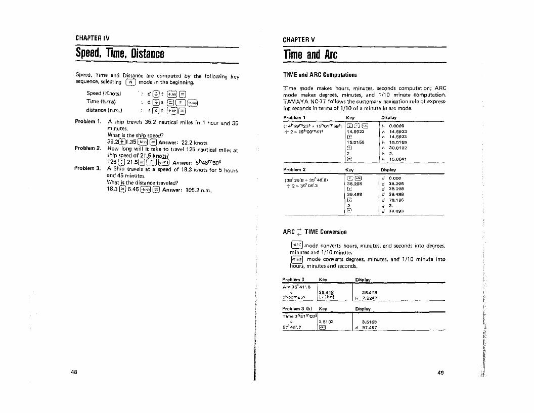
Speed, Time, DistanceCHAPTER V
Time and ArcSpeed, Time and Distance are computed by the following keysequence, selecting 0 mode in the beginning.
Speed (Knots)Time {h.ms)
distance (n.m.)
dC±Jt ~0dC±Js @Q]8
S0! ~@
TIME and ARC Computations
Time mode makes hours, minutes, seconds computation; ARCmode makes degrees, minutes, and 1/10 minute computation.TAMAY A Ne-n follows the customary navigation rule of expressing seconds in terms of 1/10 of a minute in arc mode.
Problem 1.
Problem 2.
Problem 3.
A ship travels 35.2 nautical miles in 1 hour and 35minutes.What is the shio speed?35.2C±J1.35~ @Answer: 22.2 knotsHow long will it take to travel 125 nautical miles atship speed of 21.5 knots?125 C±J 21.5@Q]8 Answer: 5h48m50sA Ship travels at a speed of 18.3 knots for 5 hoursand 45 minutes.What is the distance traveled?18.305.45 ct;;;j;) '=' Answer: 1052=L=J . n.m.
Problem 1 Key Display
(14hS9 m23s + 15h01 msgS) lTI0a h 0.0000...;--. 2 = 1ShOO m41 s 14.5923 h 14.5923
G h 14.592315.0159 h 15.0159[±) h 30.01222 h 2.@) h 15.0041
Problem 2 Key Display
(38029~8 + 39° 48~8) [D8 d 0.000
-7- 2 "" 39°09:3 38.298 d 38.298
G d 38.29839.488 d 39.488ill d 78.1862 d 2.@) d 39.093
ARC:: TIME Conversion
(~ARC) mode converts hours, minutes, and seconds into degrees,minutes and 1/10 minute.[~TIME) mode converts degrees, minutes, and 1/10 minute intohours, minutes and seconds.
Problem 3
Arc 350 41'.8t
2r.22m 47s
Displ
35.418h 2.2247
48
Problem 3 fbI Key
Time 3 hSl m03s
t 3.510357"45'.7 B
Display
3.6103d 57.457
49

APPENDIX;EXPLANATION OF NC-71 OIGITAL NAVIGATION COMPUTER
EXTERNAL FEATURES
Trigonometric function keys
Inverse trigonometric function keys
Square root computation key
key pressed before each dual function mode key sets the2nd mode i.e. sin-I, COS-I, tan-I, P.P., FIX, CD, RM1,RM2, etc.
mode key computes the Great Circle Distance and theInitial Course. The program continues to compute Latitudeand Longitude of the Vertex, and the Latitude at anyselected Longitude on the Great Circle track.
mode key computes the Course and Distance by MercatorSailing or Parallel Sailing.
mode key computes the Dead Reckoning Position byMercator Sailing or Parallel Sailing.
mode key computes the Altitude and the true Azimuth ofthe Sun, Moon, planets and the navigational stars to obtaina Line of Position in celestial navigation.
mode key makes the computation of proportional parts.It is applied in pin-painting the GHA and DEC of theMoon and planets without using the INCREMENTS ANDCORRECTIONS table of Nautical Almanac.
mode key computes the GHA ARIES, DEC SUN, GHASUN and Equation of Time at any moment through theyear 1999.
DUAL FUNCTION KEY
MOOE SelECTORS AND KEYS
NORMAL CALCULATION MOOE KEY
SCIENTIFIC FUNCTION KEYS
CD
o key clears the programmed navigation mode and sets thenormal calculation mode.
NAVIGATION MODE KEYS
rFiX' mode key computes the latitude and longitude of fix by~ two Lines of Position.
t
I
I
NormalCalculation Key
Power Switch
2nd Mode Set Key
MemorylRecall Key'
Clear Entry Key
EntryIStartlRecall Key
Division Key
• Multiplication Key
• Minus Key
• Plus Key
• Equal Key
fAC Adaptor Connecting Terminal
D,alogue Symbol Display
Numeral Display
eNumeralKey
• NavigationMode Key
50
51

key designates South in latitude and West in longitude.
key designates North in latitude and East in longitude.
mode key computes the True Wind Direction and TrueWind Speed.
mode key computes the Course and Speed Made Goodthrough a current. This key is also used for the solution ofTraverse Sailing.
mode key computes the Course to Steer and the Speed toUse to make good a given course and speed through acurrent.
mode key computes the Course to Steer at a given speed tomake good a given course through a current.
mode key computes the Height of Tide at any selectedtime.
mode key computes the Velocity of Stream (Tidal Currentlat any selected time.
This key also converts degrees, minutes, 1110 minute intohours, minutes and seconds.(ARC to TIME or TIME to ARC conversion is made by theabove two keys. I
key converts hours, minutes and seconds into hours, 1/10hour and 1/100 hour.
key converts hours, 1/10 hour, 1/100 hour into hours,minutes and seconds.The above two keys are used in Speed, Time and Distancecomputations.
~
(g]MEMORY KEYS
[oro) mode key computes the Distance to an Object by thevertically measured angle.
Designates the decimal point of a set number.
Numeral keys to enter a number.
Clears only displayed register.
Completes the addition, subtraction, multiplication,
division functions.
Clears all the computation registers, error, etc. Resumes the beginning of the program in the navigation
programs.
Changes the sign of a displayed number.
Enters a number, starts the programmed computationor recalls the programmed memory.
omG G Sets the order of each function.
@ §J Memory keys
[RM1I!RM2! Recall memory keys
OTHER KEYS
These keys are used in connection with ~ and ~to specify the celestial body, the Sun, Moon, Venus or Marsin making the sextant altitude correction.
In ~ and §I mode or means the sighting of thelower limb and ('J[ means the sighting of the upper limbof the Sun or Moon.
mode computes the True Altitude by the standard sextantaltitude corrections at lOoC, lO13.25mb (50°F, 29.92in.).
mode computes the True Altitude at variable temperatureand atmospheric pressure. Both ~ and §£J compute the True Altitude for the Sun, Moon, planets and thestars.
mode key computes the Latitude and Longitude by noonsight (Sun's meridian passage).
key sets the computation in degrees, minutes and 1/10minute.T~is key also converts hours, minutes, seconds into degrees,mInutes and 1/10 minute.
["TIME) key sets the computation in hours, minutes and seconds.
~ 53

POWER SWITCH
Nc·n DIALOGUE SYMBOLS
Dialogue system makes the operation very easy by telling you ateach step what data to feed in. The answers are ;lIsa accompaniedby the symbols which specify the meaning,
sign after L indicates South latitudesign after /I indicates West longitude
E.: overflow error symbolminus symbol
METRIC/FEET SELECTION SWITCH
~el. In § and ~ mode the switch selects them~ input by meters, Celsius (temperature) and millibarsfc-1J (pressure), or feet, Fahrenheit and inches of mercury.pah. In ~ mode it selects the input by meters or feet.Inch
DIALOGUE SYMBOLS AND THE MEANING
h (1) Time of Slack
h (2) Time of Max.
d Vel. at Max.h' Selected Time
d' Corres. Vel.
STRM
Speed IKnot): d [J t E3 0Timelh.ms}: d[Js 08Distance (n.m.): s 0 t B G
h Time of Low
d Ht. of Low Tide
h Time of HiQh
d Ht. of Hioh Tide
Ii Selected Time
hP Horizontal Parallax
RD True Alt.
P ! Pressure
Rn Refract. Corrected Alt. d' I Corres. Ht.
Sd Semidiameter
hI: Height of Eye
SAC VAC TIDERI i Sextant Alt.
CU1 CU2 CU3
Course steered e Course to Make Good ~ Cou rse to Make Good
d Speed Thru Water d Speed to Make Good d ,Speed Thru Water
c Set (Toward) c Set (Toward) e Set (Toward)
d Drift d Drift EJ d Drift
Course Made Good c Course to Steer c Course to Steer
d Sneed Made Good d Speed Thru Water d Soeed Made Good
Rr Dip' Corrected Alt.
1: Temperature
*+Starboard
- Port
WDS
..T1ME..ARC,.h,ms
hi Hour. Minute Second
d Degree. Minute 1/10
Minute
d 1True Wind Speed
DT0r-:,-_-.,.,...-__
,--+S"Ch",i"p-,C:::o:::u,-,,,...e ~ ~ Sextant Alt.d Ship Speed hI:. ' (1) Hefght of Eye
,-+S"Ch",i"p-,C",o:c.=+.!:A"p:"p",arc.'-,W.",,0c.'.,(F-,r"om=I'~ hI:. (2) Height of Object
:od_f-A""pp,..a":-rc.'W=in"d':'S.,p:::e"'ed'- d Dist. to ObjectTrue Wind DirectionP,P, LOP
h Time (1) LH LHAd Cones. Arc d Dec.h Time (21 L Lat.d Corres. Arc R Computed Alt.h' Selected Time Azimuthd' Corres. Arc
When the power switch is in "ON" Josition the computer is powered, automatically cleared and readyfor operation in normal calculation mode.
o~
o'ffU
CD DR GC
L Lat.
" Long.e Coursed DistanceLu Vertex Lat.lIu Vertex Long.
'" Selected Long.
L' Corres. Lat.
ALM MPS FIX~ Year. Month Day h Time of Mer. Pass. L La1.h Time of Observ. Ra True Alt. II LO'lg.Ha GHA d Dec, d Interceptd Dec. ka Eqn. of Time - AzmuthH GHA Lat.ka Eqn. of Time II Long.
54 55

MEMORY CAPABILITIES
NC·77 has two user·accessible memories, M1 M2 and RMl RM2,to greatly increase the flexibility of computations. Use of thememory keys does not affect the displayed number or computa·tion in progress, so "they can be used at any point in a computation. They can save you keystrokes by storing long numbers thatare to be used several times.
Key
5 ITJCJ~GJ 10 ITJCJ0ITJ§]GJ4 0CDITJ§]
Display
2.2360679772.2360679775.3983456372.2360679778,944271908o2.236067977
8esides M1, M2 and RM1, RM2 two extra memories are providedinternally for the output of ALM, FIX, LOP, CD, DR, WDS, CU1,2, 3, and MPS, where there are two answers to be recalled alternatively.
NOTE ON DECIMAL POINT
12.1533.1533,0533.0033.0003
Enter33s
333333
3
15m
155
In NC-77 TIME is always expressed as Hours, Minutes, Seconds,and ARC as Degrees, Minutes, 1/10 minute to follow conven·tional navigation practice. The decimal point should be entered asfollows. The same rule applies to the reading of the displayedoutputs.
TIME 12h
ARC 180"25'.525'.5
5'.50'.5
Enter 180.255.255.055.005
TAMAYA & COMPANY LIMITED6-8. 3-chome, Ginza. Chuo·ku, Tokyo 104 Japan
TAMAYAInput/output of trigonometric and inverse trigonometric computa~
tion follows the same rule as ARC.
0.8 CO ~ -+ 53.078 is read as 53"07',8
In ALM (Almanac) mode the year, month and day are entered asfollows.
Precision Marine Sextants Since1925
~ALM January 2nd, 1978
12h 06m 08sEnter 78.0102
12.0608
56