task 2 traffic management improvement options … · 6.2 gdot and outlying areas ... traffic signal...
TRANSCRIPT
Phase 2 Technical Memorandum (Task #2)
CHATHAM COUNTY ADVANCED TRAFFIC MANAGEMENT SYSTEM AND TRAFFIC
MANAGEMENT CENTER STRATEGIC PLAN
TRAFFIC MANAGEMENT CENTER IMPROVEMENT OPTIONS
Prepared for:
Prepared by:
In Association with:
February 2016

ii
Table of Contents
1 Introduction ............................................................................................................................ 1‐1
2 Purpose ................................................................................................................................... 2‐1
3 Traffic Signal Systems .............................................................................................................. 3‐1
3.1 Inventory and Findings .......................................................................................................... 3‐1
4 Operational Enhancements ...................................................................................................... 4‐1
4.1 Regional Corridor Integration and Coordination ................................................................... 4‐1
4.2 Improving Existing Signal Efficiency ....................................................................................... 4‐3
4.2.1 Signal Timing ............................................................................................................. 4‐3
4.2.2 Detection .................................................................................................................. 4‐4
4.3 Regional Coordination for Signal Operations ........................................................................ 4‐4
5 Communications Options ......................................................................................................... 5‐1
5.1 Overview ................................................................................................................................ 5‐1
5.2 Current Infrastructure and Findings ...................................................................................... 5‐1
5.2.1 City of Savannah ....................................................................................................... 5‐1
5.2.2 Georgia DOT ............................................................................................................. 5‐1
5.2.3 Chatham County and Other Municipalities .............................................................. 5‐2
5.3 Recommended Communications Improvements .................................................................. 5‐2
5.4 Justification for Regional Approach ....................................................................................... 5‐3
5.4.1 Addressing Regional Needs ...................................................................................... 5‐3
5.4.2 Recurring Conditions ................................................................................................ 5‐3
5.4.3 Improved Incident Management .............................................................................. 5‐5
5.4.4 Improved System Integration and Data Sharing ...................................................... 5‐6
5.4.5 Regional TMC and ATMS Considerations ................................................................. 5‐7
5.4.6 Localization and Redundancy Considerations .......................................................... 5‐8
6 Other ITS Devices ..................................................................................................................... 6‐1
6.1 City of Savannah .................................................................................................................... 6‐1
6.2 GDOT and Outlying Areas ...................................................................................................... 6‐1
7 System Integration Options ..................................................................................................... 7‐1
8 Next Steps ............................................................................................................................... 8‐1

iii
List of Tables Table 3‐1: Signalization Inventory Summary .......................................................................................... 3‐1
Table 5‐1: Regional Goals and Objectives .............................................................................................. 5‐4
List of Figures Figure 2‐1: System Engineering Process ................................................................................................. 2‐1
Figure 3‐1: Model 332 Enclosure (left), Model 336 Enclosure (right) .................................................... 3‐2
Figure 4‐1: ICM Deployment Framework ............................................................................................... 4‐2
Figure 4‐2: ICMS Context Diagram ......................................................................................................... 4‐3
Figure 5‐1: Regional ITS Network Concept ............................................................................................. 5‐8
Figure 7‐1: Five Types of Integration ...................................................................................................... 7‐2
1‐1
1 Introduction
The Traffic Management Improvement Options Technical Memorandum summarizes the both field
and central system recommendations in the development of the Chatham County Intelligent
Transportation System (ITS) and Traffic Management Center (TMC) Strategic Plan, referred to
henceforth in this document as the ATMS Strategic Plan. The Plan is being developed under a task
order of GDOT funding contract 00010027. The recommendations in this document are based on the
recommended goals and objectives identified in the Task 1 Technical Memorandum, and referenced
as is appropriate throughout this document. Building upon these goals and objectives, this Technical
Memo describes the Traffic Management Improvement Options that have been identified to be of the
highest value to the Coastal Region. Furthermore, these options will then be further defined in such a
way to support the need(s) identified for a consolidated Regional Traffic Management Center and
System. The findings here will be used to create the necessary documentation that will serve as both
an education and marketing resource to the MPO in building and garnering support from amongst the
various regional stakeholders. It will also be a basis for project definitions for the purposes of
obtaining funding and for further system design and development activities. The program benefits
from the Regional Traffic Management Center deployments will be covered in the Task 3 Technical
Memorandum.

2 Purpose
The report follows the US Department of Transportation‐defined Systems Engineering process as is
mandated in all federally funded ITS projects. The ATMS Strategic Plan will be developed consistent
with the principles of the Systems Engineering Process for Intelligent Transportation System (ITS)
project planning, design, implementation, and operations. Note that activities performed in Phases 1
and 2 of this study fall within “Phase 0” of the Systems Engineering Process as shown in Figure 2‐1.
Figure 2‐1: System Engineering Process
In this document, an alternatives evaluation will be conducted that will identify potential
improvement options that should be considered to address short‐, medium‐ and long‐term traffic
management needs, and are consistent with the Goals and Objectives previously defined and
approved by the CORE MPO. Based on the approved goals and objectives, the alternatives evaluation
focuses on those improvement options that can be implemented over the short, medium and long
terms. The evaluation will consider the Traffic Management Center, system components, including
traffic signal controllers and cabinets, communications, other traffic management hardware and
software, and identification of regional traffic hot spots that impact congestion and mobility.
The following main sections are provided in this document:
Introduction
Purpose (this section)
Traffic Signal Systems
Communications Options
Other ITS Devices
System Integration Options

3 Traffic Signal Systems
3.1 Inventory and Findings Inventory information has been gathered for traffic signals in the City of Savannah, the City of Pooler,
and other signals located in Chatham County, as well as adjacent signals in Bryan and Effingham
counties. The focus in Table 3‐1 is on Savannah, Pooler, Chatham County and GDOT.
Table 3‐1: Signalization Inventory Summary
Agency No. of Signals % 2070
Controllers % Fiber Comms
% Wireless
Comms
# of Locations
with Video
Detection
Savannah 263 90% 50% 5% 14
GDOT 94 98% 40% 25% 9
Chatham
County 50 92%
0% 60%* 2
Pooler 8 100% 88% 0 0
*All 30 GDOT‐maintained signals in Chatham County will have wireless communications by this fall. GDOT has
offered to assist the County with communications as well, but that will be longer term.
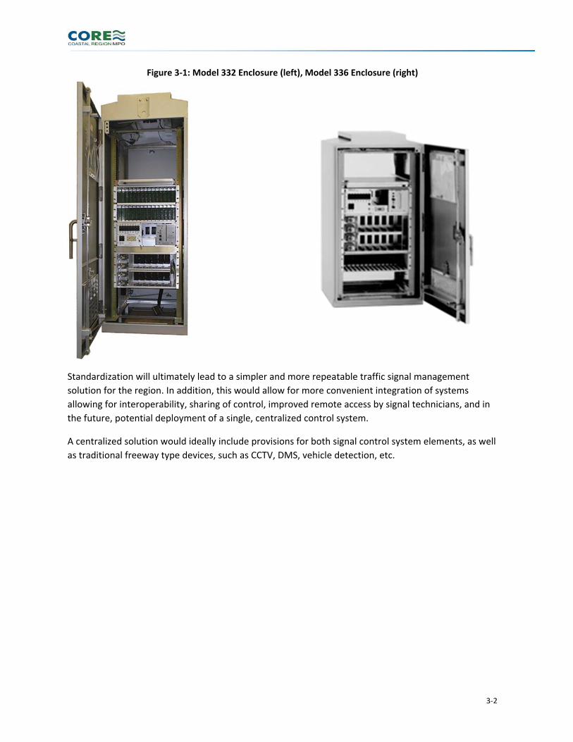
In short, nearly all of the signals in the region utilize Model 2070 controllers and associated
microprocessor rack‐based cabinets, consisting of either Model 332 ground‐mount cabinets (See
Figure 3‐1) or smaller Model 336 cabinets (See Figure 3‐1)suitable for pole, pedestal or elevated pad
mounting, all of which are useful in more congested urban environments. It was determined that the
various stakeholders are content with this field hardware, and any signalized locations in the region
not yet using these standards would benefit from this configuration, allowing for standardization of
traffic signal hardware across the region along with the potential for greater interoperability of traffic
control systems across the region, a key tenet of regional ITS activities.
As a result, there is no immediate need to upgrade/swap out most of the existing cabinets and/or
controllers within the region, except where intersection or operational reconfiguration requires
changes to the signal displays, phasing, or coordination strategies. Instead, efforts would be more
appropriately focused on the deployment of enhanced functionality and improved operational
procedures, as discussed further below. Some of that enhanced functionality does depend on the
existing controllers and cabinets.
3‐2
Figure 3‐1: Model 332 Enclosure (left), Model 336 Enclosure (right)
Standardization will ultimately lead to a simpler and more repeatable traffic signal management
solution for the region. In addition, this would allow for more convenient integration of systems
allowing for interoperability, sharing of control, improved remote access by signal technicians, and in
the future, potential deployment of a single, centralized control system.
A centralized solution would ideally include provisions for both signal control system elements, as well
as traditional freeway type devices, such as CCTV, DMS, vehicle detection, etc.

4 Operational Enhancements
The following activities have been identified as important for improved regional operations in and
around the region.
4.1 Regional Corridor Integration and Coordination One of the most promising new concepts for regional system operations is Integrated Corridor
Management (ICM). ICM incorporates many different traffic signal and ITS elements into a
coordinated and consolidated congestion response strategy. ICM is predicated on inter‐agency
coordination and communication along with addressing both traffic and transit services within a
corridor. This could range from background tools such as real‐time data sharing and analysis of
current and recent flow trends, to on‐street strategies such as transit signal priority and preferential
signal timings for particular routes and traffic flows. Ultimately, ICM strategies are intended to
improve regional transportation performance measures, including travel time reliability, reduction in
transit travel time, and ideally, improved person‐throughput across corridors and between
jurisdictions (as a result of improved transit services as well as more efficient traffic flow). Corridor
considerations may include the following major roads or streets with parallel routes:
A. “Southern Corridor” – I‐95/US 17 from US 84 to I‐16/Central Savannah B. “Northern Corridor” – I‐95/US 17 from SR 21 north of I‐16/Central Savannah C. “Western Corridor” – I‐16/US 80/Victory Drive D. “I‐516/DeRenne Corridor” – I‐516, from DeRenne Avenue to I‐16 E. “Truman Corridor” – oriented north/south along Truman Parkway and Abercorn Street, and; F. “Eastern Corridor” – Victory Drive/President Street/East Bay Street
Deployment of ICM would require the following technologies be implemented in the various corridors:
Traffic detection to determine volumes and travel speeds
Travel time measurement on key routes to determine overall performance
Tracking of transit vehicles to monitor on‐time performance, delays, and passenger loadings
Implementation of real‐time signal timing adjustments, including: – Adaptive control (anticipation of increased traffic flow based on upstream traffic
monitoring and historical data), – Bus signal priority (early green or green extension to accommodate buses with passengers
that are on or behind schedule).
Real‐time congestion, travel time and alternate route / parking information using both roadside signage (e.g., dynamic message signs) and traveler information systems (511 voice, web, mobile apps)
The ICM concept in larger cities includes, as a fundamental element, automated decision‐support
systems which permit the assembling of multiple strategies (parking restrictions in central areas, bus
transit priority, signal timing, etc.) to address a specific condition, for example, a special event, major
accident, or road closure. On a smaller scale, it may not be necessary to provide such an automated
decision‐support system without the quantity of facilities and congestion levels, so long as the ability
to monitor and manage the transportation network in real‐time is there.

4‐2
To address the combination of legacy and new devices needed to support ICM, as well as new
functions and central system components, investment needs for ICM may be separated into four
distinct components of a deployment framework as summarized in Figure 4‐1.
ICM policies, procedures, agreements and partnerships between local, regional and state agencies underpin the deployment layers
Existing field devices and control systems already in place are shown at the base layer
The second layer shows new field devices and control systems that address “gaps” needed to meet the regional multi‐modal traveler needs
The top layer represents an “ICM System (ICMS)” that would provide corridor‐wide decision support and coordinated strategies, and would be contained within the top layer.
It is expected that any regional corridor management strategies in the CORE region would focus on
partnering activities, leverage existing ITS, traffic and transit management, and adding strategic traffic,
transit and traveler information elements that would support real‐time information and addressing
different travel alternatives. In the longer term, the top‐layer decision support might be feasible
based on future population and traffic growth as well as expansion of transit services.
Figure 4‐1: ICM Deployment Framework
Source: FHWA Freeway Management and Operations Handbook, 2016 Revision
Figure 4‐2 provides a context diagram from the FHWA Freeway Management and Operations
Handbook (2016 update) illustrating the interfaces needed for an ICMS in order to integrate different
components of the transportation system, including freeway and arterial management (including
traffic signals), transit, parking, emergency management, and traveler information systems. Toll roads
are shown in the example and may be relevant should such facilities be implemented in the region in
the future. In addition to legacy systems and agency partners, new functionality may be provided that
is related to transit signal priority, transit information, parking management, and active traffic
management (e.g.., variable speed limits).

4‐3
Figure 4‐2: ICMS Context Diagram
Source: FHWA Freeway Management and Operations Handbook, 2016 Revision
4.2 Improving Existing Signal Efficiency Traffic is by nature dynamic and evolving. Any traffic system should be subject to recurring analysis to
see where changes would be beneficial. While this is largely seen as a short‐term solution, it should be
considered part of the long term ongoing operations. The area will benefit by continuing to focus on
improving the efficiency of the existing system(s). Additionally, while isolated improvements may
have significant impact, regional coordination of signals provides an opportunity for another level of
efficiency unmatched by individual signals or even systems. There are various strategies that could be
employed to meet this objective. These are presented below.
4.2.1 Signal Timing Signal timing is typically the most cost‐effective means of making an immediate improvement in the
efficiency of a signal system. Signal timing strategies are designed to minimize travel times and air
pollution, maximize fuel savings, and optimize traffic flow and progression throughout a signal
network. Under most systems, signal timing is established by predetermined traffic movements.
However, optimized signal timing is a complex endeavor. It is based on collected traffic data, and thus
based on current usage of the system. Obviously, that means a system will perform better in the
near‐term, as it is fine‐tuned to current usage trends.
But as conditions and the system itself changes in configuration (e.g., new intersections, road
widenings) and/or usage, the timings need to be revisited on a regular basis to maintain those
efficiencies. Retiming of signals is typically included and scheduled along with capital improvement
projects, providing one type of funding mechanism. Ideally, operations budgets should include regular
intervals for review and revision of signal timing, so as to not be dependent on capital improvements

4‐4
which in turn may be dependent on successfully obtaining local, state or even Federal funding. One
way of facilitating regular signal timing activities is through regional centralized control systems, which
facilitate monitoring and managing operations as well as archiving appropriate traffic data. Having
such a system also leverages the use of local operations staffs efficiently, permitting the targeting of
key corridors on an as‐needed basis and thus more targeted use of staff resources.
4.2.2 Detection Signal systems, specifically actuated systems, depend on a healthy and accurate detection
infrastructure. Regardless of other technologies, it’s extremely difficult to have an efficient signal
system without a properly configured and well maintained network of detectors. By every indication,
there are no systemic issues with detection in the regional area. However, there are always ways of
expanding and improving detection. Obvious enhancements afforded by expanded detection are
signal strategies such as adaptive and traffic responsive. There are many detection technologies
available today, from inductive loops to span wire video. The data made available from a more
extensive and robust detection network affords the flexibility to enhance both the signal system as
well as elements of a comprehensive Advanced Traffic Management System (ATMS). One key
consideration is maintenance – the detector network should be readily maintainable using available
agency resources. This also means the technology should be proven and cost‐effective. Maintaining a
healthy network of detectors is just as important as installing that network in the first place.
4.3 Regional Coordination for Signal Operations The Coastal Region has a number of jurisdictions responsible for signal operations, including the City
of Savannah, Georgia DOT, Chatham County, and other local agencies, as per the inventory in
Appendix A. The importance of freight transportation in the region (given the Port of Savannah
location northwest of the central city), the vulnerability of the region in the event of hurricanes, and
the large amount of tourist traffic point to the importance of coordinated operations and real‐time
information and coordination. Likewise, the main Interstate route into Savannah, I‐16, terminates in
Savannah and its main spur route, I‐516, terminates both in the northwest and south of the central
area. A centralized regional operations center could coordinate signals under one jurisdiction as well
as address the impacts of freight, tourist, and evacuation traffic in a regional sense. This is further
discussed below.

5 Communications Options
5.1 Overview Communications improvement options take into consideration not only traffic signal systems, but
coordination of other transportation management activities involving ITS technologies such as CCTV,
dynamic message signing, and freeway management‐related activities including system detection,
incident management, and the emerging area of active traffic management (involving tools such as
variable speed limits, dynamic lane and shoulder operations, etc.)
As presented elsewhere, the ATMS Strategic Plan is based on the three goals of reducing congestion,
enhancing travel safety, and improving regional operations. The latter consideration is of great
importance with respect to telecommunications, as it allows for potential efficiencies in designing and
maintaining wireline infrastructure to support a variety of freeway and local applications, as well as
identifying where wireless technologies could provide satisfactory and cost‐effective services. In the
future, with the advent of connected and autonomous vehicles in the coming decades, the leveraging
of both wireline infrastructure and wireless vehicle‐to‐infrastructure (V2I) and vehicle‐to‐vehicle (V2V)
communications should be considered in any investment decisions made by CORE MPO and regional
agencies.
5.2 Current Infrastructure and Findings As explained in the TMC Needs Assessment Report, communications to support a regional Traffic
Management System are lacking. There are many improvements that are recommended to better
support a centralized system operating from a regional TMC. While the Regional TMC Report to be
developed under Task 3 will address this further, there are some improvements that have already
been identified as necessary.
5.2.1 City of Savannah Generally the region has limited fiber communications coverage. The City of Savannah currently has
less than 50% of their signals connected via fiber. Additionally, the existing fiber is multi‐mode, which
allows for limited distance between communications nodes (1 km maximum for a 1 GB/second
transmission speed, less for higher speeds) and limited bandwidth capacity, which is quickly running
out. Multi‐mode fiber today is generally best‐suited for premises‐based (i.e., indoor) applications.
The City could benefit greatly by adding additional single mode fiber to its infrastructure. Not only
would the additional fiber provide greatly needed bandwidth, single‐mode would allow for greater
communications speeds over longer distances, plus greater reliability and availability through the use
of self‐healing ring networks that provide full communications coverage even if one segment of the
network is cut or malfunctions.
5.2.2 Georgia DOT From a regional perspective, other communications infrastructure upgrades are also recommended.
Given there is not currently a regional TMC, GDOT has had little need to invest in additional
connections to their signals in the area. Whether it is to increase system cooperation and integration,

5‐2
or to enhance the usefulness of the regional TMC, extending communications options and allowing for
connections to those GDOT signals in the region/district is critical. This extended infrastructure would
allow TMC operations to have a wider area of real time coverage, and wider array of options at their
disposal while managing both every day and emergent situations throughout the region.
Additionally, a connection with the GDOT network in general would be highly advantageous. This
additional connection would allow for 2‐way communications with other regional TMC’s or with
statewide operations, thus allowing for a more complete data sharing network for larger events, and
in particular, emergencies such as hurricane evacuations.
Another advantage of data‐sharing between a future Savannah regional TMC and the rest of GDOT
would include the ability to transfer control of certain devices across regional boundaries will afford
the region’s system to fit seamlessly into the statewide GDOT system, creating a more homogeneous
system throughout. This will provide robustness, flexibility, and future options to the region. The
exact advantages and realized benefits throughout the region demands additional consideration and
research. Ultimately sharing of data, just for the sake of sharing data, is not the panacea of an
efficient system. Rather, the efficient and purposeful sharing of data is what holds value. However,
that value needs to be identified before investments are made.
5.2.3 Chatham County and Other Municipalities Lastly, additional communications upgrades are necessary if the system is to include other city and
county systems within the region, consistent with the regional corridor management concepts
presented earlier. The Chatham County signal systems are largely without existing communications,
so there are many opportunities for improvement there. The City of Pooler has fiber running to many
of its intersections, but not directly connected to its signal controllers. Connections to allow
monitoring and/or control of those intersections would be advised. Obviously, evaluation of each of
the corridors, with respect to geographical and operational readiness, is required to best understand
the level of investment required.
5.3 Recommended Communications Improvements As part of upcoming tasks in development of the detailed ATMS Strategic Plan, specific
communications upgrades will be evaluated and prioritized based upon the importance and overall
value toward meeting the system goals and objectives. In addition to the new connections that will be
identified, the existing communications infrastructure will be re‐evaluated to determine if any
necessary upgrades are needed. Special consideration will be given to evaluating the age of existing
equipment, the pool of stakeholders with an interest in participating, and the potential compatibility
with a new and upgraded system.
One last important piece of the communications infrastructure will be to identify the communications
needs to support the physical regional TMC, discussed further in the Justification for Regional
Approach below. Obviously selection of a site for the TMC will be paramount to determining what
communications will be necessary. Considerations for communications, and ease of installation, are
important factors when selecting a physical location for a TMC, and will need to be evaluated
thoroughly.

5‐3
5.4 Justification for Regional Approach
5.4.1 Addressing Regional Needs The first step in addressing recurring congestion is to identify the overall transportation objectives of
the region. It should be noted that while data collection and analysis is extremely valuable, it is not a
congestion management objective in and of itself. When identifying the regional objectives, it’s
important to look at all desired modes of traffic, not simply private vehicles, but also transit and
freight traffic.
The goals and objectives were identified in the Phase II, Task 1 document and are shown in Table 5‐1
below.
Regional operations objectives were developed to be diverse enough to cover both recurring and non‐
recurring congestion. Furthermore, they serve as a guide to identifying the desired results. Those
desired results, in turn, allow the local jurisdictions to measure their performance and their
effectiveness in achieving their desired goals. The objectives do not provide the measures, but rather
guidance in their development of those measures.
Congestion issues need to be addressed both at the freeway and arterial level. This involves a
combination of statewide, regional and local resources. Statewide, GDOT manages incident and
emergencies through its NaviGATOR program (although not all regions currently have TMC facilities at
this time), and provides information through its 511 program via phone, web and mobile apps.
Regionally, Chatham County EMA has developed a Category‐5 resilient Emergency Management
Center near the Savannah Airport. Locally, City of Savannah monitors its traffic operations centrally.
5.4.2 Recurring Conditions Managing recurring congestion is critical to the vitality and ultimately the sustainability of a regional
transportation program. It’s important to remember that congestion can never be completely
eliminated. However, by properly managing congestion, the region can realize great benefit:
improved mobility, reduced GhG emissions, and generally a better quality of life for those in the
region.
There are three primary elements of congestion management. The first is real time management of
the signals in the region. Through an ATMS, with dedicated staff, and leadership commitment, great
improvements are possible. The second is through an ICM strategy for one or more corridors, as
described earlier. Coordinating between parallel freeways and transit in the region allows the
operators to achieve peak throughput. Finally, the last key element is the sharing of accurate traveler
information. Sharing of accurate traveler information between agencies and with the public can aid
with carpooling, transit, time of day trip decision making, parking management, and even congestion
pricing. In the outskirts, where alternatives are less available, traveler information on congestion can
have even greater value.

5‐4
Table 5‐1: Regional Goals and Objectives
Goals Objectives
Reduce Congestion
1 Minimize wait time at signals
2 Maximize throughput at signals
3 Minimize the number of non‐recurring incidents
4 Minimize duration of incidents
5 Minimize roadway impacts due to weather
6 Provide information to travelers on congestion/incidents
7 Reduce congestion where geometric changes are not feasible
Enhance Travel Safety on the
Road Network
8 Reduce the number of crashes in the region
9 Reduce the severity of crashes in the region
10 Provide advance warning for queues
11 Clear hazards quickly
12 Safe travel in work zones
Improve regional
transportation system
operations
13 Collect and share current travel conditions data with other agencies
14 Coordinate with other agencies on incidents
15 Increase availability of and access to data for planning, operations, and
programming purposes
16 Position the region to be able to take advantage of new tools and
technologies as they become available
Peak‐hour and off‐peak operations can be impacted greatly by traffic signal timing settings.
Conversely, freeway management for recurring conditions, and in some cases (notably I‐516), the
freeway merges into directly into the arterial network. The prevailing national and statewide
approach for providing management and information on freeways is to provide traffic flow monitoring
and travel time data collection so that real‐time travel times may be posted on dynamic message
signs, with CCTV cameras providing monitoring of congestion conditions.
On freeways with peak volumes of 1800 vehicles per lane or greater combined with heavy entrance
ramp volumes (say, 800 or more per lane per hour), a common approach to managing congestion is
the deployment of ramp metering (which entails one‐vehicle‐per‐lane‐per‐green‐signal indication,
providing one or more seconds separation between vehicles entering a freeway, which reduces

5‐5
mainline delays due to merging traffic at entrance ramps). At this time, ramp metering is assumed to
be, at best, a future component of the network.
5.4.3 Improved Incident Management When incidents occur, traffic impacts, including but not limited to lane closures and congestion,
reduce roadway capacity. Incidents can be vehicle crashes, disabled and abandoned vehicles, debris in
the roadway, work zones, adverse weather, and other events that impact the transportation system.
Incident management includes all efforts that go into the detection, response, and after‐response
associated with removing an incident, or unplanned traffic disruption of the transportation network.
It consists of a process to detect, respond to, and clear traffic incidents so that traffic flow may be
restored as safely and quickly as possible. Effective incident management not only reduces the
duration and impacts of traffic incidents; it improves the safety of motorists, crash victims and
emergency responders. The primary tools of incident management include developing procedures to
improve how traffic incidents are responded to and managed, while also developing a reliable
communication network among incident responders.
It is important for all stakeholders (encompassing TMC operators and “first responders” such as police
and fire departments) to be prepared for any type of incident management situation. Preparation for
incident management situations can be achieved through planning, training exercises, personnel
qualification and certification.
TMC responsibilities in incident management consist of:
Assisting in incident detection and confirmation/verification
Providing accurate and reliable diversion routes during emergent situations
Posting accurate and timely messaging to appropriate DMS devices
Providing accurate and near real‐time traveler information to the public and media through all required channels
Broadcasting incident information continually on Highway Advisory Radio (HAR) when possible
Coordinating Safety Service Patrol (SSP) response for the benefit of verification and/or management of incidents
By disseminating information about the incident to the public, motorists can make alternative travel
plans and delays can be reduced. Effective detection, verification, response and clearance of these
incidents can significantly reduce travel time delays. Clearing incidents rapidly is also crucial in
minimizing congestion and reducing secondary crashes. Proper incident management yields significant
benefits through reduced vehicle delays and enhanced safety to motorists through the reduction of
incident frequency and improved response and clearance times.
Ongoing incident management procedures utilize the following proven strategies for remaining at
maximum efficiency:
Annual re‐certification for all incident management team members

5‐6
Regular regional workshops to promote maximum communication and education of updated industry standard practices
Annual or Quarterly incident management Performance Reports to stakeholders to provide full transparency into operational performance
Continued financial programming necessary to maintain the program and all of its moving pieces
Incident management will occur even if it is only with the first responders on the scene. But the use of
a TMC provides many opportunities to maximize the efficiency of incident management. This includes
quicker response to conditions using ITS tools, and remote assistance to those at the scene through
monitoring on CCTV and diversion of traffic heading into the incident zone.
5.4.4 Improved System Integration and Data Sharing The most advanced traffic signal systems are made to process large amounts of data in real‐time, and
provide the programmed response to potentially rapidly changing conditions. By integrating the
various systems and providing a reliable mechanism for sharing that real‐time data, the region can
realize great benefit. In addition to the improved situational awareness amongst the systems, the
ability to analyze and/or process that data in multiple ways allows stakeholders to publish useful and
meaningful data to the general public.
Real‐time arterial detection collects different types of data depending on location. One type of
detection may be found at mid‐block locations or well in advance of a signal. These are often called
advance or system detectors, which address not only presence but volumes, speeds and flow density,
through a physical measure known as “detector occupancy”. The other type is at the actual
intersections/controllers, typically referred to as presence or stopline detection. These detect the
presence of vehicles in particular lanes and are used both to actuate a signal phase (especially for left
turn lanes or side street movements) and to extend the green display when there is a continuous flow
of vehicles over the detectors.
Additionally, the controllers can use both the system and stopline detector data as part of a traffic
responsive strategy (which selects a timing plan based on particular traffic flow criteria) or a more
fluid adaptive control system (which dynamically adjusts signal timing parameters based on advance
detector data, anticipating the volume and travel speed for platoons of vehicles, in order to reduce
stopped delay). Arterial real‐time data can be shared with other systems/jurisdictions, allowing them
to trigger other responses, such as traffic signal timing adjustments in adjacent jurisdictions. This
shared data can also be fused in a manner to make it readily available or publishable to the general
public to allow for better and more informed travel decisions. Such data typically includes travel time
measurements, but may also include travel speed information. Data can also be combined with other
multi‐modal data to allow for even more flexibility in how it might be used by the consumer. Journey
planner applications in conjunction with real‐time traveler information systems can provide
comparisons of freeway and parallel arterial travel times along with transit services between
particular customer origins and destinations.
Historical or archived data also holds tremendous value to public agencies. There are various systems
available for processing and analyzing this archived data. The archived data could grow quite large

5‐7
with time, leading to the use of the terminology of “big data.” Data analytics and data visualization
offer many possibilities for the public agency, including optimized incident management and signal
timing strategies based on comparing current conditions with normal conditions, seasonal changes, or
long‐time travel patterns. In addition to helping identify areas that need closer attention to enhance
travel throughput or efficiency, analysis of the data can help defend the need for improvements
throughout the region. Investing in data analytics is money well spent.
Analytics investments transform processes by automating the business processes associated with
turning data into information. Time that staff once spent on low‐level data acquisition (including
manual traffic counting activities), quality control, and processing can now be spent on higher‐level
business processes: analysis, decision‐making, and communication. This makes agencies more
efficient and saves money by automating tasks that previously took expensive and time‐consuming
outside consulting efforts.
As agencies begin to understand the impacts of their investments through analytics, they can improve
their overall agency performance and save their customers time and money. Because understanding
system performance is the key requirement to improving system quantitatively, the returns to agency
customers are substantial. Analytics software and services leverage existing investments in operations
data systems. Analytics approaches often entail a modest investment in software, a minimal
investment in staff, and no additional investments in hardware. Thus, the investment is relatively
modest. Because it fundamentally transforms the way that agencies do business, the payoff is large,
leading to high returns.
As agency staff incorporates analytics into their daily routines, they begin increasing opportunities to
automate data business processes and gain deeper understanding of their system’s performance. The
cumulative impact of these agency resources, saved through automation, continuously adds to the
overall return on an analytics investment. In addition, as agencies better understand their system
performance, they find new ways to improve it and serve their customers.
5.4.5 Regional TMC and ATMS Considerations Based on the above, it becomes apparent that the region would benefit from having a Regional TMC, a
coordinated/common centralized advanced traffic management system (ATMS) solution, and a
coordinated set of objectives for multiple jurisdictions within the region. GDOT support will be critical,
as will the various MPO and other jurisdictional entities. In Task 3, the Study Team will explore a
select few of the case study targets in more depth, including lessons learned, along with the various
strategies the agencies employed to build their respective TMCs and/or system upgrades. Also, the
Team will evaluate the needs/desires of the various stakeholders throughout the region, in order to
identify the elements that make the most sense to implement.
Other important benefits of a regional ATMS include coordination and data sharing throughout the
entire region and state. By deploying a robust ATMS, the area could get great benefit with sharing
transportation data and coordinating various management strategies with GDOT. By coordinating
transportation management activities, the region could provide a more coordinated approach to
managing transportation, creating a more reliable, seamless, and predictable, travelling experience by
the general public.

5‐8
5.4.6 Localization and Redundancy Considerations Given the efforts to date by agencies such as City of Savannah in special event and day‐to‐day
operations management, it is important to build upon those activities. Although the previous sections
have identified the potential benefits of regional activities, many day‐to‐day activities require
enhancing the local systems as well. Another consideration, particularly in light of hurricanes and
other weather‐related concerns, is providing a safe and secure system to support evacuations and
emergency route planning and temporary closures. This involves the use of redundant
communications design techniques (typically in the form of fiber ring networks as well as redundant
wireless links to communication hubs along the fiber network), along with redundancy of operation
(e.g., providing a back‐up operations capability in the event of a power failure or other emergency at a
primary facility).
Task 3 activities should consider both communications redundancy and TMC redundancy alternatives.
One example would be implementing a regional GDOT / county TMC within the Chatham County EMA
facility (Category 5‐resilient) while the City of Savannah maintains a local Traffic Operations Center for
its signal system, but with GDOT freeway management and other data management backups at the
local TOC. Conversely, a redundant access and hosting of the City’s signal system should be located at
the Regional TMC, with access to real‐time signal and traffic information from GDOT, county and local
signal systems accessible on a common network. By connecting the fiber ring networks to both
Centers’, redundant control, communications and management capabilities should be available in the
event of emergencies. Figure 5‐1 shows a redundant framework where a regional ring is connected to
multiple local rings of communications, with operations centers having connectivity to both the
regional ring and one local ring network in order to assure high availability through proper redundancy
and communications access.
Figure 5‐1: Regional ITS Network Concept

6 Other ITS Devices
As previously detailed, there are numerous enhancements needed for the communications
infrastructure(s) to support regional traffic signal and operations management activities. However, in
order to make a truly useful traffic management program and system, there would need to be an
expansion in coverage. The region currently has a limited number of ITS devices such as cameras,
detection and dynamic message signs. The Phase I report identified several operational and functional
concerns across the region, many of which ITS directly addresses. Locations and numbers of devices
must be developed in a more detailed study, but it is reasonable to assume that the amount of ITS
equipment is expected to increase in the coming years as the region addresses the known operational
issues.
6.1 City of Savannah The City of Savannah Traffic Department has limited numbers of ITS devices. Although there has been
installation of fiber communications to roughly half the signalized intersections and roughly 5% more
intersections with wireless communications, their additional ITS systems are limited to 6 locations
with video detection systems. In order to effectively utilize a centralized system to help manage
incidents and special events, the City will certainly need to expand the CCTV coverage area. CCTV
would provide the City with more information on daily congestion and incidents and combined with
the police department will enhance the ability to manage special events. Strategically placing CCTV
around the region at various known “hot” spots and bottlenecks would greatly enhance the ability of a
TMC to effectively move traffic and goods throughout the region. CCTV also provides enhanced
security applications in the region.
Dynamic Message Signs (DMS) should also be acquired and utilized. As mentioned in the TMC Needs
Assessment document, the region could benefit from the addition of portable message signs. DMS are
beneficial to the region by allowing for a more rapid means of disseminating important information to
the traveling public in real‐time. Permanent DMS structures and controllers can require a
considerable financial commitment. As such, additional research needs to be performed to identify
the most ideal location(s) and configurations. With the historical significance of the area, and the
associated aesthetic desires, additional considerations need to be made for the actual design and
form factor of any structures considered in the region.
The City will also benefit by expanding their existing traffic detection strategy. Enhancing their
existing detection with a network of system detection would afford the opportunity to move toward
an Adaptive Control System. Additional detection devices would also provide for even more data
collection, archiving, analytics and dissemination. Like most other considerations here, detection
needs to be designed and placed with purpose. Again, efficient analytics will provide identification of
areas/corridors that might benefit the most from additional detection coverage.
6.2 GDOT and Outlying Areas GDOT has a limited number of ITS devices locally. The DMS and CCTV that exist are mainly located
along the Interstate network. Additional CCTV coverage at key interchanges and along key arterial
6‐2
corridors would be valuable in addressing recurring congestion, incidents at ramps, and operations on
alternate routes in the event of a freeway closure or during evacuations. The region would likely
benefit from having a similar suite of device types added to local systems such as City of Savannah,
Chatham County and the City of Pooler, in conjunction with regional TMC operations activities which
would enable the monitoring of both freeway and arterial corridors.
Specific ITS device locations and enhancements should be considered based on specific location and
operations criteria which indicate that benefits are likely through deployment. Criteria may include
but not be limited to the following:
Accident rates on specific route segments
Traffic volumes on specific route segments
Travel time reliability during peak or special event traffic, along with travel time index (travel times during peak / special event periods compared to free flow travel time)
Proximity to special event venues and ingress/egress routes
Arterial route runs parallel to, and/or connects with, a parallel Interstate corridor
Route is designated specifically for major evacuations
High incident and high congestion segments of a road network may justify “full CCTV coverage” (i.e.,
close spacing of cameras, between ½ and ¾ mile, to enable viewing the entire route), while
interchanges with other Interstate routes or parallel / alternate routes may warrant implementation
of DMS in advance of these interchanges, if not already in place.
7 System Integration Options
It is assumed that the existing operational status quo is not satisfactory in the region; that in order to
address congestion, emergency management, incident management, and special event management,
new tools and functional abilities are needed. Much has been accomplished in recent years with a
large emphasis on field staff. But as the region grows and both congestion and mobility is increasingly
seen as a regional, multi‐agency concern, the integration of various activities and decision processes
becomes increasingly important.
To achieve the vision of a "seamless" transportation network, the involved agencies and practitioners
must recognize and address the many inter‐facility, inter‐jurisdictional, and inter‐modal dependencies
through the following types of integration (summarized in Figure 7‐1):
"Technical integration" of transportation operations on a regional level, specifically including network topologies, database considerations, related elements of the National ITS Architecture, standards for message sets and protocols, etc. that enable different management centers (e.g., transportation, emergency services, information providers) to readily (and automatically) exchange, store, and access information from one another – a process known as "center‐to‐center" communications.
“Institutional integration”, including identification of agency roles, interagency collaboration and coordination requirements, information sharing requirements and standards
“Procedural integration”, including coordinated planning and programming processes that address the entire surface transportation network as a whole
“Operational integration”, related to the use of the shared information for managing the transportation system (e.g., coordinated incident management, regional traveler information, adjusted signal timing and ramp metering rates)
“Physical integration”, including those systems, interfaces and infrastructure which enable cooperative and collaborative operations involving multiple agencies, facilities and modes

7‐2
Figure 7‐1: Five Types of Integration
Source: FHWA Freeway Management and Operations Handbook, 2016 Revision
Each transportation agency has a different level of deployment of control and management of their
roadways and infrastructure. Much of it is minimal in terms of electronic and real time management.
The industry has decades of history of how each individual system can be improved to provide
increased management capabilities – typically through increased number of field devices and more up
to date management systems (controllers, computers, and communications). This report has
identified multiple enhancements to the various systems throughout the region: communications,
devices, operations, etc. While these enhancements have a strong track record for improving the
operations of TMS, it is typically for the individual systems – not the region. The traveler does not see
jurisdictions; they see a region. In order to address the regional TMS needs, some level of integration
must occur between the various systems. Individual systems will need to be upgraded, but if they are
not integrated as they are upgraded, bottlenecks and choke points will continue to exist, incident
management will not improve, and the overall movement of goods and people will decline.
The enhancements identified above are based upon the expectation the area will be successful in
building a necessary Regional TMC. The system utilized within that TMC would greatly benefit from
any or all of the aforementioned enhancements. Making the Regional TMC an operational and
organizational reality is imperative for successful management of the region’s roadways. A physical
TMC should be considered necessary; the deployment of a centralized solution which incorporates the
support and resources from all the various stakeholders with an interest in participation is also critical
for achieving the most success.
The technical aspects of regional integration must not be viewed in isolation from other
considerations. Information sharing is a collaborative effort, geared towards identifying problems,

7‐3
coordinating activities, and planning for future investment needs. Technical integration can therefore
not occur without institutional integration (e.g., the various agencies agreeing on the need to share
information, their respective roles, the information to be shared, standards). Accordingly, the
institutional issues associated with regional integration are also discussed herein.
Beyond technical and institutional integration, successful regional operations also depend on
procedural integration (e.g., coordinated planning and programming processes that address the entire
surface transportation network as a whole). Moreover, after the information has been exchanged
between TMCs, something useful needs be done with it (e.g., coordinated incident management,
regional traveler information, adjusted signal timing and ramp metering rates) – that is, there must be
operational integration and the implementation of physical interfaces or components (physical
integration) to enable it.
An important first step is an organization must be created to address regional coordination. Many
regions start with a simple MPO committee, but real success is achieved when the operational staff of
each agency is working together on a daily basis. Second, communications is critical – both with field
devices and between systems. If there is one regional system, communications is simplified. But
systems could be located in different locations but be seamlessly integrated with each other over a
robust and secure communications network. Third, each system will need to expand the data
collection capabilities. This includes both sensor data and video.
There are 5 alternatives that have been initially identified:
Do nothing – maintain existing infrastructure
Agency‐specific TMC’s (one for GDOT, City of Savannah, Chatham County and Pooler)
Single regional TMC
Hybrid of Regional TMC (including GDOT and other regional entities) and City of Savannah TOC with redundant functionality (concept developed above)
GDOT miniTOPS (part of statewide deployment contract)
Multiple enhancements have been identified to the various systems throughout the region:
communications, devices, operations, etc. Those enhancements are based upon the expectation the
area will be successful in building a necessary Regional TMC. The system utilized within that TMC
would greatly benefit from any or all of the aforementioned enhancements. Again, making the
Regional TMC a reality is imperative for successful management of the region’s roadways. Not only is
a physical TMC necessary; the deployment of a centralized solution which incorporates the support
and resources from all the various stakeholders with an interest in participation is critical.
Furthermore, integration with both the GDOT system and the GDOT Operating Procedures/Strategies
will be paramount. In fact, the most advantageous scenario for the Chatham County Regional TMC is
to become a part of the existing GDOT MiniTOPs program, as an independent ITS deployment hat
would fall under a statewide service and maintenance contract.

7‐4
The above System Integration Options will need to be addressed when developing the Regional Traffic
Management plan

8 Next Steps
Additional evaluation (e.g., Signal Systems, Regional Communications, ITS systems, etc.) is needed to
identify and further develop the various alternatives presented above. Those alternatives would be
reviewed and further developed in coordination with the other local stakeholders. The alternatives
also need to be evaluated more thoroughly to determine the most appropriate use of funds when
building out the resulting TMC. Ideally we can identify other agencies that can utilize the convenience
of the resulting TMC. Those other agencies would likely include provisions for maximized
coordination amongst the co‐located entities. The consultant team has direct experience with
working in other regions to build such a coordinate inter‐agency deployment.
Additionally, the CORE MPO is planning a local Workshop / Planning session to present ideas and
stimulate discussion amongst area stakeholders in February 2016. All stakeholders and/or interested
parties are encouraged to attend, and hear from those within the region and throughout the Industry
talk about the future of the Chatham County Transportation Management initiatives.