task 3 - department of water resources 3 land retirement ... biotic communities historically...
TRANSCRIPT
Task 3
Land Retirement
Final Report
February 1999
Land Retirement Technical Committee
The San Joaquin Valley Drainage Implementation Program
and
The University of California Salinity/Drainage Program
DISCLAIMER
This report presents the results of a study conducted by an independentTechnical Committee for the Federal-State Interagency San Joaquin ValleyDrainage Implementation Program. The Technical Committee was formed by theUniversity of California Salinity/Drainage Program. The purpose of the report is toprovide the Drainage Program agencies with information for consideration inupdating alternatives for agricultural drainage water management. Publication ofany findings or recommendations in this report should not be construed asrepresenting the concurrence of the Program agencies. Also, mention of tradenames or commercial products does not constitute agency endorsement orrecommendation.
The San Joaquin Valley Drainage Implementation Program wasestablished in 1991 as a cooperative effort of the United States Bureau ofReclamation, United States Fish and Wildlife Service, United States GeologicalSurvey, United States Department of Agriculture-Natural ResourcesConservation Service, California Water Resources Control Board, CaliforniaDepartment of Fish and Game, California Department of Food and Agriculture,and the California Department of Water Resources.
For More Information Contact:
Manucher Alemi, CoordinatorThe San Joaquin Valley Drainage Implementation ProgramDepartment of Water Resources1020 Ninth Street, Third FloorSacramento, California 95814(916) [email protected] visit the SJVDIP Internet Site at:http://wwwdpla.water.ca.gov/agriculture/drainage/implementation/hq/title.htm

2
The San Joaquin Valley Drainage Implementation Program
Land Retirement Technical Committee Final Report
February 10, 1999
Active Land Retirement Technical Committee:
Wes Wallender (Chair) University of California, DavisClu Cotter Department of Water ResourcesThomas Harter Kearney Agricultural CenterPatrick Kelly San Joaquin Valley Endangered Species Recovery
Planning ProgramStephen Lee U.S. Bureau of Reclamation, FresnoBob May U.S. Bureau of Reclamation, FresnoDale Mitchell Department of Fish and Game, FresnoPhil Nixon Lost Hills Water DistrictTheresa Presser U.S. Geological SurveyJim Rhoades U.S. Salinity LaboratoryJohn Shelton San Joaquin Valley Endangered Species Recovery
Planning ProgramJeff Single Department of Fish and Game, FresnoKen Swanson Westlands Water DistrictLarry C. Turnquist Redfern RanchesArthur Unger University of California, RiversideMarca Weinberg University of California, DavisJoan Wu Washington State University
Active Non-committee Members:
Manucher Alemi Department of Water ResourcesJohn Letey University of California, RiversideMichelle Selmon San Joaquin Valley Endangered Species Recovery
Planning ProgramCurt Uptain San Joaquin Valley Endangered Species Recovery
Planning ProgramWayne Verrill Department of Water Resources

3
Land Retirement Technical Committee Report
Outline
I. Introduction………………………………………………………………….………………..…….….7
Purpose and Goals of the San Joaquin Valley Drainage Program…………………..…..……...7Land Retirement Recommendation of the SJVDP……………………………………….….….…8SJVDP Land Retirement Planning Alternatives……………………………………..………...…..9SJVDP Land Retirement Definition, Basis, Criteria, and Objectives……………………….…..11
II. Technical Committee Objectives………………………………………………….………….….…14
III. Recent Actions/New Information/Developments……………………………………….…….......15
Central Valley Project Improvement Act (CVPIA) Land Retirement Program………..…….…15State Land Retirement Program……………………………………………………………….…..18Other Land Retirement Programs……………………………………………………………….…18CVPIA Land Retirement Demonstration Project and the Donohoe Pilot Project……………..19
IV. Technical Evaluations/Results of RRLRP and Other Alternatives………………………….….21
A. Hydrologic Consequences for Water Conservation, Drainage Reduction, and SeleniumReduction………………………………………………………………………………………..21
DFE Model Background………………………………………………………………………..24Drainage Reduction……………………………………………………………………….……27Habitat Restoration………………………………………………………………………….….28Sustained Agricultural Productivity…………………………………………………………...35Comparisons and Other Modeling Exercises………………………………………………..37
B. Biologic Consequences for Wildlife Habitat…………………………………………………..40
Introduction……………………………………………………………………………………...40Biotic Communities Historically Occurring within the Program Study
Area………………………………………………………………………………………...…42Occurrence of Existing Habitat…………………………………………………………….….45The Potential of Retired Lands to Benefit Wildlife…………………………………………..46Potential Negative Effects to Wildlife from Land Retirement………………………………49Considerations for Maximizing Biological Benefits……………………………………….....53Conclusions and Recommendations………………………………………………………….54

4
C. Pedologic Consequences of Land Retirement and Related Issues…………………...……55
Potential for Soil Salinization Following Land Retirement…………………………………..55Reasons for Suspecting Soil Salinization Problems in Retired Lands…………………….57Theoretical Processes of Water Flow and Salt Transport in Unsaturated Soils…………59Estimates of Soil Salinization Resulting from Land Retirement……………………………61Suitability of Retired Lands for Dryland Agriculture………………………………………….66Reclamation (Leaching) Requirements of Salt-affected Soils……………………………...68Drainage Requirements for Reclamation………………………………………………….….70Alternative Land Retirement Strategies: Soil Degradation Implications……………….….71
D. Economic Analysis of Land Retirement…………………………………………………….….73
Introduction……………………………………………………………………………………….73Lessons from Existing Land Retirement Programs……………………………………….…73Characterizing the Economic Optimum……………………………………………………….76Site Selection for Retired Parcels……………………………………………………….……..77Alternative Objectives…………………………………………………………………….……..80Importance of the Time Horizon……………………………………………………….……….81
V. Summary and Recommendations…………………………………………………………………...83
References………………………………………………………………………………………………….91
Appendix [CVPIA Section]……………………………………………………………………………….101

5
LAND RETIREMENT COMMITTEE REPORT
Scope of the Committee Report
Chapter I
The SJVDP estimated abandonment of up to 460,000 acres of lands dueto drainage problems including soil degradation by salinization by the year 2040.The land retirement option for retirement of 75,000 acres of land by the year2040 as presented by the SJVDP is intended to enable agricultural production tocontinue at present levels in the future by reducing amounts of “problem water”and “problem acreage”. Chapter I summarizes the purpose and goals of theSJVDP, the land retirement recommendation of the SJVDP, and the definition,strategy, concept, areas of concern, basis, criteria, and objectives of landretirement.
Chapter II
A chronology of the SJVDIP since adoption of the Proposed Action Planon December 11, 1996 and subsequent steps leading to preparation of a seriesof reports including Technical Reports is given in Chapter II. The responsibilitiesof the Technical Committees and specific objectives to be fulfilled by theTechnical Reports are listed. The Committee objectives and the scope of thereport are also presented.
Chapter III
The CVPIA Land Retirement Program also is focused on minimizingdrainage problems so that more land may continue to be used for agriculturalpurposes. Chapter III discusses the Central Valley Project Improvement Act(CVPIA) Land Retirement Program, the San Joaquin Valley Drainage Relief Act,the U.S. Department of Agriculture’s Conservation Reserve Program and theWetland Reserve Program. An update is also given concerning theEnvironmental Assessment, the Finding of No Significant Impact for theExpanded Demonstration Project of the CVPIA Land Retirement Programincluding various cooperative agreements with Westlands Water District.
Chapter IV
Implementing the land retirement option as presented by the SJVDP andthe CVPIA is not without some expense in converting lands to other uses andmanaging water, soil, land, and wildlife resources to minimize adverse effectsand maximize beneficial effects. Chapter IV describes the potential

6
consequences of the implementation of land retirement upon the hydrologicsystem (Section A), upon the quality of land from a biologic perspective(Section B) and a pedologic perspective (Section C), and upon the economicsystem (Section D). The results described in this section are based on computermodeling studies. Studies of this type have inherent limitations based onmodeling assumptions, availability of data for modeling verification, and theaccuracy of model predictions of natural phenomena. For the modeling studiesdescribed in this report, little baseline data was available for model verification. Therefore, modeling results must be carefully reviewed and interpreted based onmodeling assumptions. In the absence of retired land monitoring data, theresults of the modeling studies provided the best framework for Committeedeliberations on the environmental and economic consequences ofimplementation of land retirement programs.
Chapter V
The analysis by the Subcommittee contains limitations that have beenlisted, to some extent, in the introductions to the chapters themselves. The factthat the chapters remain independent at this point underscores the experimentalnature of land retirement. Chapter V gives recommendations concerning theimplementation of land retirement to help both sustain agriculture and reduce riskto the environment. To achieve this balance, specific research needs areidentified.
Because the Subarea Reports contained few details on implementation ofland retirement, the subcommittee could not assess in detail the specifics ofGrassland, Westlands, Tulare, and Kern hydrologic systems that have beenbrought successfully under management control or the efficacy of otherimplemented management options that could be used in conjunction with landretirement (e.g., groundwater pumping) in each subarea.

7
I. INTRODUCTION
Purpose and Goals of the San Joaquin Valley Drainage Program
The San Joaquin Valley Drainage Program (SJVDP) from 1985 to 1990was a dedicated effort to resolve the subsurface drainage water problem of thewestern San Joaquin Valley (SJV) (SJVDP, 1989 and 1990, see especiallyPrefaces to both volumes, pages iii, and iv in 1989 and pages iii and one in1990). With implementation of the regional plan of specific managementalternatives (SJVDP, 1990, Table 1), progress would be made both in managingand treating drainage-water toxicants associated with ecotoxicity within the valleyand developing long-term solutions to address the elevated groundwaterconditions and the annual salt build-up that eventually limit the uses of valleylands and groundwater. The strength of the SJVDP lies in its concerted,cooperative approach and its suggested framework of alternatives built on aregional perspective from documented studies. Benefits would occur during the50-year program period as agricultural production continued at present levels(SJVDP, 1990, Table 46), without predicted abandonment of lands due tosalinization (SJVDP, 1990, Tables 11 and 45), and as fish and wildlife resourceswere restored and protected from the adverse effects of selenium in receivingwaters (SJVDP, 1990, Tables 41, 42, and 44). Monitoring, initially and continuingthroughout the program period based on the developed regional framework,would add site-specific data and analysis necessary for evaluating the long-termsuccess of the SJVDP.
The initial scientific documentation which provided the basis for the choiceof management alternatives, including land retirement, was an important part ofthe SJVDP. An extensive library (e.g., SJVDP, 1989; SJVDP, 1990, pages 163-175) of supporting measurements, technical analysis, maps, and models exist tohelp quantify drainage conditions, understand drainage management, andassess the benefits from a regionally implemented plan. The initial assessmentincluded a compilation of historical data, execution of baseline field studies forthe period 1985 through 1988, and development of planning objectives, criteria,and performance standards based on water-quantity, water-quality (i.e.,protection of aquatic life, wildlife, and public health) and land use (SJVDP, 1990,Tables 7, 15, 16). Some final documentation of field studies was published afterthe completion of the summary report of the SJVDP (e.g., for land retirement, seeBelitz and Phillips, 1992; for Tulare Basin, see Fujii and Swain, 1995) and furthertechnical analysis of the work of the program continues to be published (e.g.,Dinar and Zilberman, 1991; and Frankenberger and Benson, 1994;Frankenberger and Engberg, 1998).
8
Land Retirement Recommendation of the San Joaquin Valley DrainageProgram
Retirement of irrigated agricultural lands was a management componentof the SJVDP to achieve load reduction, in general, of dissolved constituentsand, in particular, of trace elements such as selenium, present in subsurfacedrainage generated from lands of the western valley. Characteristics to identifyirrigated farmlands for selective land retirement were developed (e.g., a regionalmap showing selenium (Se) concentrations greater than 50 and 200 parts perbillion (ppb) in shallow ground water, SJVDP, 1990, Figure 23). This allowedspecific criteria to be applied to the identified subareas (i.e., Northern, Grassland,Wetlands, Tulare, and Kern) to estimate the number of acres applicable to landretirement, the amount of associated problem water reduction, and amount ofwater freed-up to restore and enhance drainage-contaminated habitat in theidentified subareas (SJVDP, 1990, Tables 1, 2, 23, 24, 29, 32, 35, 38, 41, and42).
The adverse effects, limitations, and benefits of each management optionwere evaluated by the SJVDP (SJVDP, 1990, Table 17). Potential negativeeffects listed for land retirement included loss of agricultural productivity, perhapspermanently, and loss of revenue to surrounding communities. Uncertaintiesincluded those associated with reuse of retired lands as wildlife habitat, withretired-land maintenance including dust control, with potential preservation ofretired lands in reserve for future re-introduction to irrigated or dry-landagriculture, and with institutional changes concerning repayment of federal andstate water contracts. Benefits would accrue from economic return to thelandowner from the sale of property, the sale or lease of irrigation water supply,the reduced cost of handling drainage, and allocation of freed-up water tobeneficial uses, and the reduced risk of selenium exposure to fish and wildlife.
Implementation of land retirement as envisioned by the SJVDP wouldconcurrently reduce problem water and conserve or free-up good-quality water(SJVDP, 1990, Tables 22 and 24). Amounts of water needed for the protectionand restoration of fish and wildlife resources also were identified by the SJVDP(SJVDP, 1990, Table 42). In general, the amount of problem water reduction(SJVDP, 1990, Table 2) compared to the amount of water potentially availablethrough the recommended plan actions (SJVDP, 1990, Tables 41 and 44) give ameasure of the overall impact of land retirement. For the recommended plan, theamount of water potentially made available (SJVDP, 1990, Table 41) divided bythe amount of problem water reduced (SJVDP, 1990, Table 2) is the highest (3.6)for the land retirement option when compared to groundwater management (2.1)and source control (1.6) options. Comparisons among alternatives also wereperformed using other measures or criteria (e.g., the social cost of landretirement compared to the social cost of implementing alternative drainagemanagement methods, Stroh, 1991).
The final recommended management plan for each subarea included

9
development of alternatives based on emphasizing: (1) conservation and reuseof agricultural water, (2) extraction of irrigation water from the semi-confinedaquifer, and (3) retirement of irrigated agricultural lands overlying shallow groundwater containing greatly elevated concentrations of dissolved selenium (SJVDP,page 98, Tables 18 through 22, and Figures 25, 26, and 27). One of theconclusions of the alternatives analysis used in the formulation of the finalrecommended plan concerning land retirement was that the land-retirement-component should be maximized if minimizing risk from toxicants was thedominant objective (SJVDP, 1990, page 118). Specifically, if lands overlyingareas of shallow ground water with concentrations of selenium exceeding200 ppb were retired as priority candidates, land retirement would achieveselenium load reduction as opposed to a management or redistribution of load ona temporal basis (e.g., reuse and source control). If conserving water at least-cost is the maximized objective, source control and reuse options should bepursued. However, formulation of the final recommended plan for landretirement by the SJVDP, as with the other components, was based on factorsspecific to the subareas and sites considered (e.g., ability to discharge to the SanJoaquin River or closed basin), as well as an overall plan formulation (SJVDP,1989; SJVDP, 1990, e.g., Figure 28, drainage reduction). The decision to retirelands made by the SJVDP did not preclude the future option of re-establishingirrigated agriculture if circumstances should change (SJVDP, 1990, page 121).
In the following section, excerpts from the SJVDP’s final report (1990) givea summary of the land retirement management alternative as it was originallyconceived. In the final section, details of the planned implementation of theregional land retirement alternative have been compiled and referenced. Thesedetails include the definition, basis, criteria, and specific objectives(e.g., applicable acreage, amount of problem water reduction) of therecommendation.
San Joaquin Valley Drainage Program Land Retirement PlanningAlternatives
Drainage Management Strategies Underlying the (Planning) AlternativesLand Retirement (SJVDP, 1990 excerpts, page 103 and narratives ofFigure 22 and 23):
Land Retirement:
The essential strategy of land retirement is to stop irrigating lands withpoor drainage characteristics beneath which now lies shallow ground water socontaminated with selenium (and other substances) that drainage would beextremely difficult and the water produced would be costly to manage. Hydrologic investigations (Gilliom, et al., 1989) indicate that, if substantial landarea (say +5,000 acres) were retired from irrigation, the shallow water tablebeneath those lands would drop. To some extent, instead of contributing to their
10
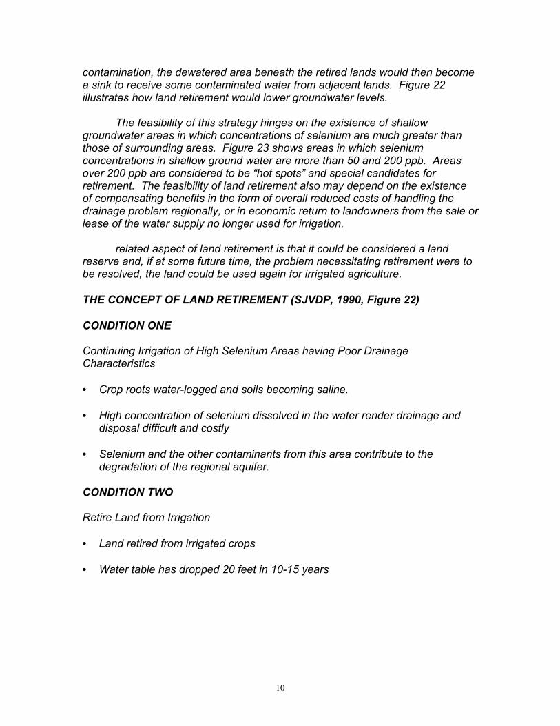
contamination, the dewatered area beneath the retired lands would then becomea sink to receive some contaminated water from adjacent lands. Figure 22illustrates how land retirement would lower groundwater levels.
The feasibility of this strategy hinges on the existence of shallowgroundwater areas in which concentrations of selenium are much greater thanthose of surrounding areas. Figure 23 shows areas in which seleniumconcentrations in shallow ground water are more than 50 and 200 ppb. Areasover 200 ppb are considered to be “hot spots” and special candidates forretirement. The feasibility of land retirement also may depend on the existenceof compensating benefits in the form of overall reduced costs of handling thedrainage problem regionally, or in economic return to landowners from the sale orlease of the water supply no longer used for irrigation.
related aspect of land retirement is that it could be considered a landreserve and, if at some future time, the problem necessitating retirement were tobe resolved, the land could be used again for irrigated agriculture.
THE CONCEPT OF LAND RETIREMENT (SJVDP, 1990, Figure 22)
CONDITION ONE
Continuing Irrigation of High Selenium Areas having Poor DrainageCharacteristics
• Crop roots water-logged and soils becoming saline.
• High concentration of selenium dissolved in the water render drainage anddisposal difficult and costly
• Selenium and the other contaminants from this area contribute to thedegradation of the regional aquifer.
CONDITION TWO
Retire Land from Irrigation
• Land retired from irrigated crops
• Water table has dropped 20 feet in 10-15 years

11
• Selenium and other contaminants do not contribute to the degradation of theregional aquifer
• Possibility that retired areas become a sink for the poor quality water innearby shallow ground water
Map of Areas of Highest Observed Selenium Concentrations In ShallowGround Water (SJVDP, 1990, Figure 23)
• exceeds 50 ppb Se
• exceeds 200 ppb Se
San Joaquin Valley Drainage Program Land Retirement Definition, Basis,Criteria, and Objectives
Definition
Intentionally discontinuing irrigation of selected farmlands.
Basis
• Land retirement would remove from production those farmlands contributingthe poorest quality subsurface drainage water, thereby reducing the volumeof problem water by approximately 0.65 - 0.75 acre-feet/acre/year (ac-ft./ac/yr.) (SJVDP, 1990, Table 26), and improving the quality of drainagewaters to be managed. Lands overlying areas of shallow ground water withconcentrations of selenium exceeding 200 ppb Se are identified as thoselands contributing the largest percentage of selenium to drainage discharge(SJVDP, 1990, Figure 23). The shallow groundwater table beneath retiredfarmlands is predicted to drop based on a regional assessment ofimplementation of retiring land of a substantial area (SJVDP, 1990,page 103; Belitz and Phillips, 1992; Swain, 1990).).
• Land retirement would free-up irrigation water (2.2 - 2.8 ac-ft./ac/yr., page118) for potential reallocation to beneficial uses (e.g. wetlands, in-streamflows).
• Retired farmlands could potentially be managed as wildlife habitat althoughthis type of land reuse is unproved in the SJV (SJVDP, 1990, Table 17). Inorder to ensure that habitat benefits were realized, it is likely that such retiredlands would have to be managed as uplands. Surveys of the lands(Endangered Species Act consultation and NEPA compliance) would takeplace prior to selection and a comprehensive monitoring plan would be inplace to determine the safety of these lands to wildlife and to documentrestoration changes. Restored terrestrial habitats could benefit a number of
12
species, including endangered and threatened plants and animals. Habitatbenefits would be greater with larger block sizes (e.g., > 5,000 acres) inproximity to existing wildlife areas and other undeveloped lands, and asadditional farmland retirements provided corridors. Intentional efforts toreplant/reintroduce grasses, forbs, and shrubs would speed up habitatrestoration and increase the presence of native plants. The addition of micro-relief to the landscape would benefit burrowing animals. (Moore et al., 1990;SJVDP, 1990; Swain, 1990).
Criteria
Recommended for retirement were irrigated farmlands with the followingcharacteristics (SJVDP, page 103, Tables 7, 15,16, 23, and 24, and Figure 23):
• Large, contiguous blocks of farmland (> 5,000 acres);
• Farmlands with low agricultural productivity (USBR land classes 4 and 6, orStorie Index classes 4, 5, and 6);
• Farmlands with shallow groundwater table (< 5 or < 10 feet below thesurface);
• Farmlands with poor groundwater quality (> 50 ppb Se); and
• Lands overlying areas of shallow ground water with concentrations ofselenium exceeding 200 ppb Se are special candidates for retirement.
Objectives
Applicable acreage (SJVDP, 1990, Tables 15 and 16)
• 55,100 acres (Level A, > 200 ppb Se)
• 263,900 acres (Level B, > 50 ppb Se) (see Footnote #1 concerning correctionof SJVDP, 1990, Table 16)
Recommended Acreage (SJVDP, 1990, Tables 24, 29, 32, 35, 38)
• 21,000 acres (year 2000)
• 75,000 acres (year 2040)
Problem Water Reduction (SJVDP, 1990, Table 2, 29, 32, 35,38)
• 16,000 acre-feet/yr. (year 2000)
13
• 55,300 acre-feet/yr. (year 2040)
Freed-Up Water through Implementation of SJVDP Management Options(SJVDP, 1990, Table 41)
• 56,000 ac-ft./yr. (year 2000)
• 199,000 ac-ft./yr. (year 2040)
Reallocated Water Uses (SJVDP, 1990, Table 42)
Total of Annual Water Needs for Fish Protection, Substitute Water Supply forWildlife Areas, and Alternative Habitat for Evaporation Ponds
• 167,400 ac-ft./yr. (2000)
• 193,900 ac-ft./yr. (2040)
Annualized Costs of the Recommended Plan over the 50-year program period(SJVDP, 1990, Table 3 and pages 5 and 118, and Table 17; the value ofconserved water for other uses has not been included as a cost offset)
• Purchase of land/year $2,818,000 ($140,900,000 annualized over 50 yearperiod at 10% interest; approximate cost per acre $1,500-1,900)
• Operation, maintenance, or replacement/year $300,000
• Annual costs/acre of land served, $170
Footnote #1: The number of acres (453,900) reported for the extent of land considered for landretirement under Level B Performance Standards, from SJVDP, 1990, Table 16, page 94, isincorrect. The problem is a misprint for the number of acres for the Kern Subarea, Zone A (219.5Ac. in the table, interpreted as 219.5k Ac.). The size of the entire Kern Zone A is less than 30,000acres, and the area with selenium >50 ppb may be verified with the data on page 5-58 of theTechnical Information Record, Documentation of the Use of Data, Analysis, and EvaluationProcesses that Resulted in the SJVDIP Recommended Plan (SJVDP, September, 1990). Themisprint for Kern Zone A should likely have read 29.5k Ac., yielding a total Level B acreage of263,900, instead of 453,900 (personal communication, Wayne Verrill, 10/7/98)

14
II. TECHNICAL COMMITTEE OBJECTIVES
The following paragraphs are excerpts from the SJVDIP Activity Planadopted by the SJVDIP Management Group on March 24, 1997.
“On December 11, 1996, the Management Group of the San JoaquinValley Drainage Implementation Program approved, in concept, a “ProposedAction Plan,” advanced by an association of local districts, the University ofCalifornia, and the California Department of Food and Agriculture, to update theManagement Plan. This Activity Plan will be carried out in three stages.
The first stage in updating the Management Plan will consist of twoconcurrent, coordinated, and independent tasks. One task will be thepreparation of reports on San Joaquin Valley drainage problem areas by SubareaCommittees which will assess the progress toward, and constraints of, adoptingmanagement recommendations in the Management Plan. The second task willbe current technical and economic evaluation of the management optionsproposed in the Management Plan and salt utilization by a set of technicalcommittees.
The second stage will be synthesis of the information reported underactivities of the first stage into a report which identifies interactions betweenmanagement options, trade-offs between management options, and a set ofrecommendations based on technical and economic considerations. This taskwill be accomplished by an “Ad Hoc Coordination Committee.”
The third stage will use the recommendations formulated during thesecond stage along with input from the public sector to formulate an updatedmanagement plan and identify acceptable mechanisms conducive to adoptionand voluntary implementation of the updated management plan.
Technical Committee Responsibilities
Technical Committees will conduct an assessment analysis of issuespertaining to drainage in the San Joaquin Valley. The analysis shall includetechnical and economic parameters. Individual Technical Committees will: (1) evaluate the subject areas of the major components of the Management Plan,together with salt utilization, on the basis of recent and current research andresults of pilot projects, (2) review the Subarea reports, and (3) prepare reportsfor the Ad Hoc Coordination Committee. Institutional and fish and wildlifecomponents of the Management Plan will be addressed by TechnicalCommittees as appropriate. Technical Committees will list all options in eachcomponent area, conduct a technical and economic evaluation of all options thatare ready for implementation, identify the feasible area of application along withlimitations, and identify additional work needed on options. Committee reportswill make a separate analysis for each Subarea as appropriate, identify tradeoffsassociated with each alternative course of action, and identify areas needing

15
further study.”
The Land Retirement Technical Committee will carry out theresponsibilities assigned to the technical committee on land retirementcomponent of the Rainbow Report. Thus the committee will evaluate the landretirement component of the Rainbow Report on the basis of the recent andcurrent research, pilot projects, and other recent actions including relevantinformation contained in the subarea reports submitted to the Committee. The committee’s specific objectives are to:
• Review the assumptions and criteria of the Rainbow Report;
• Present an overview of land retirement-related actions taken sincepublication of the Rainbow Report in 1990;
• Identify consequences (impacts on environment and economy) and benefits(contribution to selenium impact reduction) of Rainbow Reportrecommendation on land retirement;
• If necessary, make recommended changes to the Rainbow Report criteria,assumptions, and recommendation;
• Recommend how Rainbow Report land retirement may be implemented toreduce risk to the environment, provide safe habitat for wildlife, and sustainagricultural productivity; and
Identify research, evaluation and data needs.
III. RECENT ACTIONS/NEW INFORMATION/DEVELOPMENTS
Central Valley Project Improvement Act (CVPIA) Land Retirement Program
On October 30, 1992, Congress enacted the Central Valley ProjectImprovement Act (CVPIA, Public Law 102-575). Section 3408(h)(1), Title 34 ofthe CVPIA authorized a federal land retirement program, as recommended bythe San Joaquin Valley Drainage Program Final Report (San Joaquin ValleyDrainage Program 1990). The CVPIA modified the priorities of the Central ValleyProject (CVP) and established aggressive goals for the restoration of the fish andwildlife in California’s Central Valley. The CVPIA provided the Secretary of theInterior with a number of authorities as tools to accomplish those goals. At the same time, the CVPIA recognized that additional management andmeasurement tools were needed and would be developed over time.Land retirement is one of the management tools authorized to assist in theachievement of CVPIA goals. Other options include improvements in ormodifications of the operations of the CVP, water banking, conservation,transfers, and conjunctive use.

16
Section 3408(h)(1) of the CVPIA authorizes the purchase, from willingsellers, of land and associated water rights and other property interests whichreceives Central Valley Project water under a contract executed with the UnitedStates. Section 3408 (h) (2) of the CVPIA authorizes the Secretary of the Interiorto purchase agricultural land which, in the opinion of the Secretary, (A) would, ifpermanently retired from irrigation, improve water conservation by a district, orimprove the quality of an irrigation district’s agricultural wastewater and assist thedistrict in implementing the provisions of a water conservation plan approvedunder section 210 of the Reclamation Reform Act of 1982 and agriculturalwastewater management activities developed pursuant to recommendationsspecific to water conservation, drainage source reduction, and land retirementcontained in the final report of the San Joaquin Valley Drainage Program (1990);or (B) are no longer suitable for sustained agricultural production because ofpermanent damage resulting from severe drainage or agricultural wastewatermanagement problems, groundwater withdrawals, or other causes.
The U.S. Bureau of Reclamation (Reclamation), in partnership with theU.S. Fish and Wildlife Service (USFWS) and the U.S. Bureau of LandManagement (BLM) are the responsible Federal agencies for implementing theCVPIA Land Retirement Program. Representatives from each of these agenciesmake up the Inter-agency land retirement team and will work in partnership toaccomplish the goals of the land retirement program. The program is expectedto retire a total of about100,000 acres of irrigated farmland. The actual amount of land retired andduration of the program will be dependent upon the number of willing sellers andbudget constraints. All land considered for retirement must come from willingsellers. Reclamation will not use condemnation to acquire land or other propertyinterests. The USFWS and the BLM will act as land managers for lands acquiredunder the CVPIA Land Retirement Program.
All lands that receive Central Valley Project (CVP) water are eligible forparticipation in the land retirement program. However, it is anticipated that alllands selected for retirement will be located south of the Sacramento-SanJoaquin Delta where drainage and water quality are poor. This area wasidentified as the project area for the San Joaquin Valley Drainage Program FinalReport (San Joaquin Valley Drainage Program 1990). There are approximately1.8 million acres of irrigated farmland located south of the Sacramento-San Joaquin Delta that receive CVP water. Many of these lands have elevatedconcentrations of selenium in the soils and shallow ground water. Elevated levelsof salinity, boron, molybdenum, and arsenic also are present on many lands.
In 1994, Reclamation and DWR conducted several public workshops inthe Central Valley, Sacramento, and San Francisco Bay Area. Those workshopsexplored the level of interest and concerns among landowners, environmentalinterests, local water suppliers, and drainage interests. Reclamation then

17
developed Draft Interim Procedures and Guidelines in consultation with DWRand finally published interim guidelines (see Appendix A) after much consultationwith various agencies, interested organizations, and members of the public (U.S.Department of the Interior 1997). The guidelines address procedures forsoliciting lands eligible for retirement; a process for selecting lands for retirement(criteria); the role of local water districts in setting priorities for retirement;interests that might be acquired; and post-retirement management of land andwater resources. It is anticipated that the guidelines will be further refined (hencethe term “interim”) based on information generated through the Land RetirementDemonstration Project. The demonstration project was the subject of a recentEnvironmental Assessment and Finding of No Significant Impact and involvesretiring a parcel of land within the Westlands Water District and developinghabitat enhancement strategies to test through an adaptive managementapproach. The Interagency Land Retirement Team expects to develop amonitoring plan and adaptive management strategy for the demonstration projectand use the parcel to refine strategies to land and water management within thecontext of land retirement.
The land retirement program is based on an eight-stepprocess-solicitation of offers; submission of applications by willing sellers; reviewof applications; selection of parcels for retirement; appraisal of the propertyvalue; preparation of land use and water management plans; site-specificenvironmental impact analysis of parcel retirement; retirement of land; andimplementation of management plans.
The ranking criteria includes depth to groundwater, seleniumconcentration in groundwater, salinity of groundwater, boron concentration ingroundwater, soil drainage classification, risk of exposure to contaminated water,(This ranking criteria considers if the parcel to be purchased has active drainageto the SJR or a pond and/or if the parcel has potential to drain to the SJR or apond.), parcel location, potential to restore habitat, parcel size, and amount ofwater available. Through these criteria, lands that have drainage andgroundwater quality problems would be selected and retired from agriculturalproduction. Given that another purpose of the program is to improve fish andwildlife habitat, large blocks of land with drainage and groundwater qualityproblems located next to other retirement lands or existing wildlife habitat will begiven higher priority.
The following research activities are being funded by the CVPIA Land RetirementProgram:
2-Dimensional Ground Flow Model in the Panoche Water District, 1997,Purkey, D.R. and Wallender, W.W., U.C. Davis. Model simulates thehydrologic impacts of land retirement at the local farm field scale. (Thisproject has been completed and is summarized in section D1.)

18
Update of the U.S.G.S. Ground Water Flow Model for the Western San JoaquinValley. In progress by J. Fio, Hydrofocus Inc. Model will be used to simulatethe hydrologic impacts of land retirement at the regional scale.
Contributed funding for the UC Davis Study entitled, Water and LandManagement in Irrigated Ecosystems, Wallender, W.W. and others. Inprogress. An agricultural-economic model to quantify the economic,environmental and social impacts of reductions in surface water supplies, andreductions in lands irrigated in the vicinity of Firebaugh.
Land Retirement Demonstration Project, Endangered Species RecoveryProgram. In progress. Provides funding for the study of revegetation, habitatrestoration, and monitoring of retired demonstration project lands.
State Land Retirement Program
Concurrent with passage of the federal CVPIA, the California legislaturepassed Senate Bill (SB) 1669, the San Joaquin Valley Drainage Relief Act, in1992. This bill incorporated recommendations of the San Joaquin ValleyDrainage Program, including the authorization of a state land retirement program(California Water Code, Section 14900) to be administered through the CaliforniaDepartment of Water Resources (DWR). The state land retirement program isnot currently funded; however, the federal government is moving forward with theCVPIA Title 34 requirements and the federal environmental review process.
Other Land Retirement Programs
The largest land retirement program in the country is the ConservationReserve Program (CRP). Originally authorized in the Food Security Act of 1985,the CRP is administered by the U.S. Department of Agriculture (USDA) with agoal of reducing soil erosion from highly erodible crop lands. The CRP is amedium-term program in which farmers submit bids representing their willingnessto accept payment to remove their land from agricultural production. By 1989 theUSDA had enrolled 33.9 million acres of cropland into the CRP. In contrast tothe land retirement program envisioned for the drainage problem area, whichcovers a longer time horizon, winning CRP bids retire land for a10 year period and landowners retain title to the parcel and are free to resumecrop production upon contract expiration.
CRP focus appears to have been on the quantity of land enrolled, ratherthan on the environmental benefits of enrolling land (Wu and Babcock, 1996). Beginning in 1987, water quality objectives took increasing prominence in CRPdesign, with filter strips, cropped wetlands, and lands subject to scour erosiongaining eligibility (Osborn et al., 1995). In particular, those parcels that are bothhighly erodible and adjacent to an impacted water way would receive higherpriority for entry into the program than, for example a similar parcel that either is

19
less erodible (e.g., is not steeply sloped) or is farther from the water course. Although originally established to address soil erosion problems, this programhas been gaining attention recently for its potential to provide environmentalservices, such as wildlife habitat (e.g., Szentandrasi, et al., 1995). More recentrounds of the CRP have attempted to incorporate environmental objectives byenrolling only environmentally sensitive lands (Wu and Babcock, 1996). About2.5 million additional acres were enrolled under these new rules.
Prominent among other land retirement programs is the WetlandsReserve Program (WRP), administered by the USDA in a similar fashion to theCRP, but with an objective of preserving the nation's wetlands. Farmersparticipating in the WRP sell long-term production easements to the government. Interior's Bureau of Reclamation may implement a program toretire agricultural lands in the Colorado River Basin to help reduce salt loading,and enhance fish habitat, in that river (Ekstrand and Johnson, 1995).
CVPIA Land Retirement Demonstration Project and the Donohoe PilotProject
The USBR at this writing is preparing environmental documentation on theCVPIA Land Retirement Program that includes an expanded DemonstrationProject up to 15,000 acres. The expanded project is in response to commentsreceived during public meetings on the Land Retirement Demonstration ProjectDraft EA. Concerns were expressed that the planned 1,891 acre DemonstrationProject would be too small to support statistically credible analyses, would notdemonstrate the resulting effects on upslope versus downslope groundwatermovements, and would not assess varying impacts of retiring lands with differentdrainage characteristics. In addition, an expanded Demonstration Project wouldbe needed to confirm the accuracy of the fundamental assumptions of theprogram, such as reductions in drainage-related impacts, before implementinglarge-scale land retirement of up to 100,000 acres.
In response to these comments, the USBR has expanded the LandRetirement Demonstration Project from 1,891 acres to 15,000 acres. Theadditional acreage will come from the voluntary sale of drainage impacted landsmeeting USBR criteria within western Fresno County, southeastern KingsCounty, and southwestern Tulare County. The expanded project will include the1,891 acres previously identified, and will expand with as yet unspecified landsfrom the Westlands subarea to include land with different soil, water, anddrainage characteristics in the Tulare subarea. The specific purpose of theDemonstration Project is to determine if the current criteria for selection of landsin the Land Retirement Program Interim Guidelines are adequate to accomplishthe mission of the Program to reduce drainage, improve water quality in the SanJoaquin River, establish wildlife habitat, and determine which restorationtechniques and land management options will work best under various scenarios.

20
The USBR has negotiated a cooperative agreement with Westlands WaterDistrict regarding lands retired within WWD. Some of the terms of thecooperative agreement are:
1. The first 15,000 acres of lands in the District lands that are retired are to beretired pursuant to the agreement;
2. The amount paid by Interior for the purchase of retired land shall be the valueof the land absent any appreciation due to the availability of Project water; theDistrict will pay the difference between that value and the full fair market valueof the land up to $1,150 per acre;
3. The District will be permitted to reallocate the CVP water to which the retiredlands are entitled to other lands in the District, provided that they do not liewithin the designated drainage-impacted region of the District;
4. Interior may apply for an allocation from the District supplemental watersupply for the purpose of establishing vegetation on retired lands for uplandhabitat.
The Expanded Land Retirement Demonstration Project EnvironmentalAssessment (EA) is currently being revised in response to comments receivefrom interested stakeholders. The EA will include analysis of alternatives notconsidered in the original document regarding disposition of water. Thecooperative agreement with WWD has been suspended until the environmentalimpacts associated with the agreement can be analyzed and publicly disclosed inthe EA. It is anticipated that the EA will be available for public review early in1999.
The land retirement goals of the USBR expanded program compare withthe SJVDP 1990 Management plan recommendation to retire 18,000 acres ofland in the Westlands subarea and zero acres within the Tulare subarea by theyear 2000. By the year 2040, the recommendation was to extend retirement to atotal of 33,000 acres in the Westlands subarea, and 7,000 acres in the Tularesubarea.
IV. TECHNICAL EVALATIONS/RESULTS OF RRLRP AND OTHERALTERNATIVES
A. HYDROLOGIC CONSEQUENCES FOR WATER CONSERVATION,DRAINAGE REDUCTION, AND SELENIUM REDUCTION
Agriculture in much of the Western San Joaquin Valley (WSJV) receivesirrigation water from the Federal Central Valley Project (CVP). In enacting theCentral Valley Project Improvement Act in 1992, Congress responded to thetension underlying land retirement by authorizing a program in which willing

21
sellers of land receiving CVP water, and located within the drainage problemarea, could sell property to the Interagency Land Retirement Team (ILRT),although no authority was granted to retire land without the consent of the owner(Benson 1997). In order to evaluate land parcels offered to the ILRT, a set ofselection criteria were developed. According to these criteria, the primaryobjective of any land acquisition is to reduce the quantity of agricultural drainagegenerated in the region. Mitigating the drainage problem associated withirrigated agriculture in the WSJV is the primary concern. Additional benefits ofland retirement could include, however, habitat restoration for the threatened SanJoaquin kit fox, giant kangaroo rat, blunt-nosed leopard lizard, and Nelson’santelope ground squirrel and long term preservation of the regional agriculturalproduction base (Mays 1997). What follows is an investigation of systemresponses to different land and water use patterns in the context of the CVPIAland retirement program. This work as done at the specific request of the ILRTand addresses certain scenarios of interest to evaluate actual land retirementstrategies. What emerged is a general framework for evaluating land retirementprograms.
The drainage reduction, agricultural productivity, and habitat restorationeffects of various land retirement strategies implemented on the west side of theSan Joaquin Valley (Figure 1) were evaluated using a model (Purkey andWallender 1998). The two-dimensional, vertical transect groundwater model(Purkey et al. 1998a, 1998b) was derived from a non-Dupuit formulation oftransient, unconfined groundwater flow equations (Neuman and Witherspoon1970, 1971) and configured for a portion of the Panoche Creek alluvial fan of thewestern San Joaquin Valley (Figure 1).
Figure 1. The Western San Joaquin Valley of California, Including the MajorHydraulic Infrastructure and the Location of Groundwater Modeling (each gridsquare is 640 acres).

22
The DFE model built upon a number of other modeling exercises, many ofwhich took a regional view of hydrologic conditions and water managementoptions. Seminal work by Belitz and colleagues (1992, 1995) described thehydrology and resource use across a large portion of the western San JoaquinValley. In contrast to this regional effort, Purkey and colleagues studied asmaller area at higher spatial resolution to better understand the local effects ofmanagement options such as land retirement. Modeling work conducted by Wuand colleagues (1998) was similar in scope to this effort, although only Purkey etal. specifically investigated the effects of land retirement on habitat restorationand agricultural productivity. This involved translating the simulated depth to thewater table along the transect (Figure 2) in the short (1000 days or approximately3 years), medium (5000 days or approximately 13 years) and long term (18,250days or 50 years) into indicators of habitat suitability and agricultural productivity. These results are compared to those reported by other investigators in latersections.
Figure 2. Deforming Finite Element Model Transect With Up Gradient (Field 3)and Down Gradient (Field 5) Parcels in Relation to the San Luis and DeltaMendota Canals, Water Table Elevation Contours, and the DrainageInfrastructure of the Panoche Drainage District.

23
DFE Model Background
Details of the Deforming Finite Element (DFE) model used to simulateaquifer conditions below a portion of the western San Joaquin Valley (WSJV)under a variety of land retirement scenarios are presented elsewhere (Purkeyand Wallender 1998) and only a summary is provided herein. Five landretirement scenarios were simulated (Figure 3) along with a “no retirement”baseline. The “contiguous” scenarios mimic the retirement of the entire modeltransect while the “patchwork” scenarios retire either Field 3 (up grade) or Field 5(down grade) as shown in Figure 2. These correspond to 640 acre (2.6 km2)township and range land sections. Within the contiguous and down gradescenarios, sub-scenarios related to the operation of installed sub-surface tiledrains were also considered. The assumption that no new tile drainage systeminstallation would occur was adopted. To simulate land retirement the aquiferrecharge rate was set to 0.0 m/day for the entire 50 year simulation of a retiredparcel.
Retire:
Drains:
MODEL
Entire Transect 640 acresUp Grade
640 acresDown Grade
Closed ClosedOpen Open
Figure 3. Simulated Land Retirement Strategies.
The 8.1 mi. (11.380 km) long transect from the groundwater divide to nearthe Delta Mendota Canal (Figure 2) extends down through the entire unconfinedsurficial aquifer to the top of the Corcoran Clay (Figure 4). Transects placedperpendicular to the ground surface contours on alluvial fans should encounterthe typical patterns of concentric water table elevation contours (Figure 2). Thesoil texture varies from course at the upper end of the fan to fine down gradienton the fan along the model transect. The transect captures the essence ofconditions on the coalescing alluvial fans which dominate the WSJV.

24
Figure 4. DFE Model Transect with Boundary Conditions and Drain Tile NodeLocations (NNE is the direction North Northeast).
Extrapolating the available twelve year record of piezometric surfaceelevations in the confined aquifer below the Corcoran Clay over the entire50 year retirement simulation was challenging. To construct a time series, the 12year long USGS database of the piezometric surface elevation in October, 1972,1976, and 1984 (Belitz and Phillips, 1992) was extended using water levelmeasurements taken up to 1994 in the WWD (Westlands Water District) well(Figure 5) approximately 1.86 mi. (3 km) from the upgradient end of the transect.The rapid drop in the piezometric surface elevation corresponds with the1987-1992 drought during which pumping from the confined aquifer increased. An additional 12 years of data came from repeating the pattern recorded in theUSGS database, followed by extrapolation of the final rate of change elevationwith time over the remaining16 years. The form of the piezometric surfaceelevation captures the general recovery of the piezometric surface which hascontinued since the importation of surface water into the WSJV starting in the1950s, and the potential interruption of this trend by a drought, characteristic ofCalifornia’s variable hydrology.

25
Figure 5. Assumed Evolution of the Piezometric Surface Elevation in theConfined Aquifer below the Corcoran Clay.
Lateral flow to the transect (flow perpendicular to the direction of thetransect) is assumed zero for the two-dimensional model. To fully satisfy thisassumption, fields perpendicular to the transect should be managed the sameway as the field at the transect. The assumption is violated, for example, if fieldslateral to a retired field are not retired because the lowering of the water table atthe transect will induce lateral flow to the transect. The error is particularly largein the case of contiguous retirement, where a special quasi-three dimensionalformulation of the DFE model has been adopted to mitigate the error. Thepotential modeling error suggests that simulated land retirement scenariosshould be viewed as representations of the system response rather thanabsolute predictions of how the land retirement program would affect theprevailing hydrologic regime in the WSJV. In any case, the no retirementbaseline simulation, which is not affected by this modeling assumption, is thereference for evaluating scenarios.
-200
-150
-100
-50
0
50
100
150
200
0 2000 4000 6000 8000 10000 12000 14000 16000 18000
time since retirement (days)
piez
omet
ric S
urfa
ce e
leva
tion
(ft)
USGS Database
Extend with WWD
Repeat USGS
Extrapolate USGS
26
Drainage Reduction
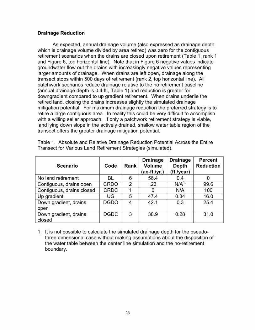
As expected, annual drainage volume (also expressed as drainage depthwhich is drainage volume divided by area retired) was zero for the contiguousretirement scenarios when the drains are closed upon retirement (Table 1, rank 1and Figure 6, top horizontal line). Note that in Figure 6 negative values indicategroundwater flow out the drains with increasingly negative values representinglarger amounts of drainage. When drains are left open, drainage along thetransect stops within 500 days of retirement (rank 2, top horizontal line). Allpatchwork scenarios reduce drainage relative to the no retirement baseline(annual drainage depth is 0.4 ft., Table 1) and reduction is greater fordowngradient compared to up gradient retirement. When drains underlie theretired land, closing the drains increases slightly the simulated drainagemitigation potential. For maximum drainage reduction the preferred strategy is toretire a large contiguous area. In reality this could be very difficult to accomplishwith a willing seller approach. If only a patchwork retirement strategy is viable,land lying down slope in the actively drained, shallow water table region of thetransect offers the greater drainage mitigation potential.
Table 1. Absolute and Relative Drainage Reduction Potential Across the EntireTransect for Various Land Retirement Strategies (simulated).
Scenario Code RankDrainageVolume
(ac-ft./yr.)
DrainageDepth
(ft./year)
PercentReduction
No land retirement BL 6 56.4 0.4 0Contiguous, drains open CRDO 2 .23 N/A1. 99.6Contiguous, drains closed CRDC 1 0 N/A 100Up gradient UG 5 47.4 0.34 16.0Down gradient, drainsopen
DGDO 4 42.1 0.3 25.4
Down gradient, drainsclosed
DGDC 3 38.9 0.28 31.0
1. It is not possible to calculate the simulated drainage depth for the pseudo-three dimensional case without making assumptions about the disposition ofthe water table between the center line simulation and the no-retirementboundary.

27
Figure 6. Simulated Cumulative Drainage Over 50 Years Under a Variety ofLand Retirement Strategies: BL Baseline No Retirement; CRDO ContiguousRetirement Drains Open (nearly zero, Table 1); CRDC Contiguous RetirementDrains Closed (zero, Table 1); UG Up Gradient; DGDO Down Gradient DrainsOpen; DGDC Down Gradient Drains Closed.
Habitat Restoration
In addition to reducing the volume of drain water generated in the WSJV,a land retirement goal is to restore wildlife habitat. For suitable habitat the watertable must not lie too close to the ground surface. A high water table below aretired parcel could lead to direct water table evaporation and the deposition ofsalt at the land surface (Section D.3). In addition to preventing salt deposition, awell aerated soil profile(low water table) will allow target terrestrial species to construct dry burrowsconducive to successful breeding and rearing of young.
To define a well aerated soil profile, a threshold value of the depth togroundwater of 7 ft. (2.13 m) has been established based on empirical evidence
-70
-60
-50
-40
-30
-20
-10
0
0 10 20 30 40 50
time since retirement (years)
drai
nage
from
7.0
7 m
ile tr
anse
ct (f
t)
BLCRDOCRDCUGDGDODGDC

28
that water table evaporation is extinguished by this depth in Panoche Clay Loamsoil (Nielsen et al. 1973). When the simulated water table below a retired parcelof land is deeper than this threshold, it is considered to have suitable habitatvalue. This depth, however, may be too shallow according to simulation resultsreported in Section D.3.
No Retirement Baseline
The simulated evolution of the water table profile for the no retirementbaseline shows that the zone of shallow water continues to move up fan over thecourse of the simulation. The portion of the transect with a water table depthshallower than 7 ft. (2.13 m) expands in the up slope direction (Figure 7). The upgradient Field 3, which started as a well aerated parcel, eventually has a highwater table by the end of the50 year simulation, as well as a small portion of the field located immediately upslope. Without a change in management, the continued practice of irrigatedagriculture in the WSJV is problematic.
Figure 7. Simulated Depth to Groundwater Below the DFE Model Transect forthe Baseline No Retirement Case After Approximately 3 Years (1000 Days), 13Years (5000 Days), and 50 Years (18,250 Days).
Contiguous Retirement
-5
0
5
10
15
20
25
30
35
40
45
50
55
600 1.01 2.02 3.03 4.04 5.05 6.06 7.07
distance NNE of groundwater mound (miles)
dept
h be
low
gro
und
surf
ace
(ft)
Initial Condition3 years13 years50 yearsGround SurfaceCritical Depth
Field 3 Field 5

29
For the contiguous retirement scenario, when the drains below the retiredtransect are left in operation the shallow water table disappears (Figure 8) within1000 days of retirement. The entire transect lying along the center line of thequasi-three dimensional retirement area (Figure 9) is suitable habitat. Thisquasi-three dimensional formulation assumed that at some reasonable distancefrom the transect the water table would remain unaffected by retirement andwould contribute lateral inflow to the transect. The water table rises between 13and 50 years despite the lack of aquifer recharge (Figure 8). This is caused bythe increase in piezometric pressure below the Corcoran clay (see Figure 5)coupled with sustained lateral inflow. The associated decrease in the hydraulicgradient reduces the magnitude of downward flow across the Corcoran clayrelative to lateral inflow. This imbalance causes an increase in groundwaterstorage and the water table rises.
Figure 8. Simulated Depth to Groundwater for the Contiguous Retirementwith Drains Open.
-10
0
10
20
30
40
50
60
70
800 1.01 2.02 3.03 4.04 5.05 6.06 7.07
distance NNE of groundwater mound (miles)
dept
h be
low
gro
und
surf
ace
(ft)
Initial Condition3 years13 years50 yearsGround SurfaceCritical Depth

30
Figure 9. Quasi-Three Dimensional DFE Model Formulation Used toSimulate the Contiguous Retirement Strategy.
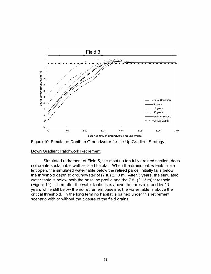
Up Gradient Patchwork Retirement
Retirement of Field 3 immediately up fan of the currently installed tiledrainage network controls the up slope progression of the zone of shallowgroundwater relative to the baseline (the light gray lines in Figure 10). Thepercentage of the transect having suitable habitat remains essentially constantover 50 year simulation.
31
Figure 10. Simulated Depth to Groundwater for the Up Gradient Strategy.
Down Gradient Patchwork Retirement
Simulated retirement of Field 5, the most up fan fully drained section, doesnot create sustainable well aerated habitat. When the drains below Field 5 areleft open, the simulated water table below the retired parcel initially falls belowthe threshold depth to groundwater of (7 ft.) 2.13 m. After 3 years, the simulatedwater table is below both the baseline profile and the 7 ft. (2.13 m) threshold(Figure 11). Thereafter the water table rises above the threshold and by 13years while still below the no retirement baseline, the water table is above thecritical threshold. In the long term no habitat is gained under this retirementscenario with or without the closure of the field drains.
-5
0
5
10
15
20
25
30
35
40
45
50
55
600 1.01 2.02 3.03 4.04 5.05 6.06 7.07
distance NNE of groundwater mound (miles)
dept
h be
low
gro
undw
ater
(ft)
Initial Condition3 years13 years50 yearsGround SurfaceCritical Depth
Field 3

32
Figure 11. Simulated Depth to Groundwater for the Up Gradient Strategy.
Maximum Habitat Value
A deep, well drained unsaturated soil profile can provide useful habitat forthreatened terrestrial organisms. Shallow groundwater (less than 7 ft.) cancause soil water logging and salt accumulation which degrade habitat value(see Rhodes et al., Section D.3). Precipitation over the retired parcel will tend tocounteract this effect. Water extraction by plant roots may tend to accentuate it.More modeling and field studies are needed to determine if 7 ft. is sufficient toprevent upward movement of salt into the root zone.
Results showing the percentage of the transect with the water tabledeeper than 7 ft. (2.13m) are summarized in Figure 12 for the near- (3 years),medium- (13 years), and long-term (50 years). Less habitat is restored andsustained when down gradient fields are retired compared to up gradient fields. At the moment of retirement, there is no benefit of retiring Field 5 with the drainsopen or closed (DGDO, DGDC) because the field has a shallow water table. After 3 years the water table falls below 7 ft. (2.13 m) in a portion of the retiredparcel and this portion is enhanced by leaving the drains open. The continued
-5
0
5
10
15
20
25
30
35
40
45
50
55
600 1.01 2.02 3.03 4.04 5.05 6.06 7.07
distance NNE of groundwater mound (miles)
dept
h be
low
gro
und
surf
ace
(ft)
Initial Condition3 years13 years50 yearsGround SurfaceCritical Depth
Field 5

33
increase in piezometric pressure below the Corcoran Clay layer, however,causes the water table to rise in the longer term and the habitat gains are lost.
Figure 12. Simulated Evolution Of Percent Of Land With A Water Table DeeperThan 7 ft. (2.13 m) For Land Retirement Strategies.
The comparative advantage of each land retirement scenario in terms ofcreating habitat value is summarized in Table 3 and Figure 12. Recall that if thewater table under the retired land is deeper than 7 ft., the habitat is classified assuitable. If entire parcel is underlain by suitable habitat, then the fraction inFigure 14 is one which is the case for up gradient retirement scenario which isranked number one (Table 3). Thus, by retiring up gradient land, a greaterfraction of the transect is suitable, in the short and long term, for habitatcompared with down gradient retirement strategies. At the moment of itsretirement, Field 3 (UG) lies up slope of tile drains and is free from the habitatdegradation associated with a shallow water table. According to the simulations,it remains well aerated throughout the intervening 50 years because the watertable depression below Field 3 delays up slope encroachment of the shallowwater zone. The contiguous retirement scenario also results in immediatesuitable habitat enhancement along the center line of the up slope area butwould require approximately two years in the down-fan area.
0
0.2
0.4
0.6
0.8
1
0 1000 5000 18000time since retirement (days)
frac
tion
retir
ed w
ith D
TW>c
ritic
al d
epth
BLCRDOCRDCUGDGDODGDC

34
Table 2. Simulated Value of the Habitat Restoration Proxy of Various LandRetirement Strategies Along with the Resulting Ordinal Values.
Scenario Code RankTemporalAverageHabitatBenefit1
No land retirement BL 5 0Contiguous, drains open CRDO 2 0.861Contiguous, drains closed CRDC 2 0.861Up gradient UG 1 1.0Down gradient, drains open DGDO 3 0.161Down gradient, drains closed DGDC 4 0.041
1. The temporal average habitat benefit is the average of the four valuesplotted in Figure 12.
Sustained Agricultural Productivity
In carrying out a land retirement program another goal is to minimize theadverse impact on agricultural production and the economy of the WSJV. Forthese simulations we assume that the retirement of one unit of land will have thesame impact on the local economy, whether it is part of a contiguous area or anisolated section. Retiring this land will also affect the water table disposition andtherefore the productivity of land along the transect that remains in production. The percentage of the transect which remains actively irrigated and undrainedwith a water table below 7 ft. (2.13 m) is the criteria used to assess suitability foragricultural production. For example, the percentage is zero for the contiguousretirement scenario. Although the water table is deeper than 7 ft., none of theland is irrigated.
Results for the scenarios are shown Figure 13 for the near-, medium- andlong-term. By retiring an up gradient parcel, Field 3 (UG), there is an immediatedecline in agricultural productivity because land is taken out of productionbecause this parcel was initially unaffected by shallow groundwater. In the shortterm eliminating non-drainage impacted land is immediately deleterious to theagricultural productivity; in the long term the up slope field is the preferred option. This certainly highlights the importance of comparing short and long termeconomic impacts as discussed in Section D.4.
As shown in Figure 10, retirement of Field 3 suppresses the water tableunder the undrained portion of the next field down the fan. It is sufficient to movethe water table below the 7 ft. (2.13 m) threshold. In the long term, this downslope suppression is not maintained, although all well aerated land above Field 3remains free from shallow groundwater throughout the simulation.

35
Figure 13. Simulated Evolution of the Agricultural Productivity, the Fraction ofTotal Transect Which Remains Irrigated and Undrained
In the case of down gradient retirement (DGDO, DGDC), the response isquite different. Removing Field 5 from production had no impact on the amountof well aerated, irrigated and undrained land remaining in production because itwas drained. Its initial fraction is the same as that of the baseline no retirementscenario in which no undrained land is retired. With time, however, productivitydeclines for both the base line and the down gradient scenarios because thezone of shallow groundwater expands up slope until it underlies both Field 3 anda portion of the adjacent up slope neighbor. This represents a loss in productivitybecause Field 3 is initially irrigated and undrained in this scenario.
In the short-term, more land is kept productive by retiring down gradientfield than by retiring up gradient fields. In the long term more land is keptproductive by retiring the up gradient field compared to the down gradient fieldbecause the increase in piezometric pressure below the Corcoran Clay causesthe water table to rise, even in the upslope reaches of the transect. Byforestalling the up slope migration of the shallow water table zone, retirement ofan up gradient parcel actually protects the two fields located up slope along thetransect from future degradation. For the no retirement baseline and downgradient retirement options, the margins of these fields eventually come intoproximity with the simulated high water table zone.
0
0.2
0.4
0.6
0.8
1
0 1000 5000 18000
time since retirement (days)
irrig
ated
and
und
rain
ed fr
actio
n
BLCRDOCDRCUGDGDODGDC

36
Agricultural productivity results are summarized in Table 4. Recall thatagricultural production is classified as sustainable if the water table is deeperthan 7 ft. below irrigated land. The fraction expressed in Table 4 is the proportionof entire transect which meets this criteria. For example, in the case of downgradient retirement 0.437 of the transect remains productive after3 years resulting in a number one ranking (Table 3). After 18,250 days (50 yrs.)the ranking falls to two and three for the drains open and closed cases,respectively. At that time the up gradient retirement scenario is ranked numberone because 0.294 of the transect remains productive. This time dependentresult demonstrates the challenge of choosing between the short- and long-termbenefits and costs of different land retirement strategies. As in many resourcemanagement situations the problem reduces to balancing short term economicgain with long term sustainability. Growers appreciate the higher return for suchan investment in later years. For example in recent years a large number oforchards and vineyards have been planted on the up slope regions of the alluvialfans in the WSJV. These added income benefits, however, may not outweighthe added drainage and habitat costs.
Table 3. Simulated Agricultural Productivity for Various Land RetirementStrategies After Approximately 3 Years (1000 Days) and 50 Years(18,250 Days).
Fraction Transect Irrigated andUndrained
1000 Days 18,250 DaysScenario Code % Rank % Rank
No land retirement BL .436 2 .246 4Contiguous, drains open CRDO 0 4 0 5Contiguous, drains closed CRDC 0 4 0 5Up gradient UG .342 3 .294 1Down gradient, drains open DGDO .437 1 .257 2Down gradient, drainsclosed
DGDC .437 1 .256 3
Comparisons with Other Modeling Exercises
Using a regional groundwater model which covered approximately550 mi2 of the Little Panoche, Panoche, and Cantua Creek alluvial fans, Belitzand Phillips (1995) reported similar results. These authors simulated downgradient land retirement on the 224, 1 mi2 horizontal cells underlain by a shallowwater table (less than 7 ft. or 2.13 m) at the start of the simulation. In a mannerakin to down gradient retirement in the DFE, when these cells received no furtherrecharge during a 50 year simulation, the water table fell below the 7 ft. (2.13 m)threshold. Unfortunately, the up slope growth of the zone of shallow groundwatercontinued under this scenario as an additional 107 mi2 of up gradient landexperienced the onset of water logging over the course of a

37
50 year simulation (as compared with 120 cells under a no retirement baselinesimulation). This result is similar to the simulated DFE water table responseduring down slope retirement shown in Figure 11.
Under a checker board pattern of land retirement on the 224 mi2 ofdegraded down gradient land, an additional 117 mi2 of land became waterlogged, while non-retired cells surrounded by retired cells experienced only a 3%decline in drainage. In the DFE model this is akin to evaluating drainagereduction from Fields 4 and 6 when Field 5 is retired. In the current analysis,which has greater field to field numerical refinement, simulated drainagereduction from unretired fields exceeds that reported by Belitz and Phillips. According to Table 4, retirement of Field 5 with the drains left open, reduces thesimulated short term drainage in Field 4 by 11.2% and in Field 6 by 7.1%. In thelong term, the drainage reduction from these fields range from 3.1% to 4.4%,respectively.
Table 4. Simulated Drainage Rate Reduction from Drained Fields 4 and 6 whenUp Slope Field 3 and Adjacent Field 5 are Retired, in ft./year.
Years Since the Start of the Simulation3 13 50
Field Baseline .438 .766 1.5444 Retire Field 3 .304 .310 .880
% change -30.6 -59.5 -42.9Retire Field 5, closedrains
.405 .734 1.555
% change -7.6 -4.1 0.8Retire Field 5, leavedrains
.390 .712 1.496
%change -11.2 -7.2 -3.1Field Baseline .661 .748 .887
6 Retire Field 3 .653 .726 .872% change -1.1 -2.9 -1.6Retire Field 5, closedrains
.628 .730 .905
% change -4.7 -2.4 2.2Retire Field 5, leavedrains
.613 .708 .847
%change -7.1 -5.44 -4.4
Belitz and Phillips did not comment upon the retirement of currentlyundrained land, up slope of the zone of shallow groundwater. This is thescenario investigated through the simulated up gradient retirement of Field 3 (seeFigure 10). In this case, the further up slope progression of shallow groundwaterwas arrested and actively irrigated up slope land remains free from a shallow

38
water table. This strategy also produced a dramatic reduction in drainage fromField 4, immediately downstream from the retired land(see Table 4) ranging from 30.6% to 42.9% after approximately 3 years and50 years, respectively.
The results of Wu’s simulations (1998) suggest a similar hydrologicresponse to land retirement. Contiguous retirement of both up and downgradient lands is the most effective method of lowering the water table andreducing drainage (0.049 ft./year as opposed to 0.706 ft./year in a baselinesimulation). When only a portion of a transect along an alluvial fan can beretired, down slope retirement (0.539 ft./year) more drastically reduces drainagethan up slope retirement (0.563 ft./year). Up slope retirement, however, doesstem the expansion of the zone of shallow groundwater.
B. BIOLOGICAL CONSEQUENCES FOR WILDLIFE HABITAT
Introduction
Prepared by: Curt Uptain, ESRP; John Shelton, DWR; Patrick Kelly, ESRP;Dale Mitchell, DFG; Jeff Single, DFG; Michelle Selmon, ESRP; Clu Cotter, DWR

39
The 1990 Final Report on San Joaquin Valley Agricultural Drainage(SJVDP 1990)) did not address potential benefits of agricultural land retirementto wildlife resources, other than those which would accrue from site-specific (andpresumably overall) reductions in the quantity and toxicity of drainwaterassociated with removal of the most contaminated soils from the irrigationpattern. In particular, the potential for retired agricultural lands to support wildlifehabitat was not considered. Given the dramatic decline in native habitats in theCentral Valley, the contributions that could be made to restoring habitat throughthis program are substantial.
This discussion is primarily concerned with the potential for retired lands tofunction as upland habitat. A number of San Joaquin Valley biotic communitiescan be classified as upland, including Valley Saltbush Scrub, Valley Sink Scrub,Non-native Grassland and Valley Sacaton Grassland. Upland habitat refers onlyto dry-land habitats, not wetlands, and can occur on either upslope, downslope,upgradient or downgradient lands. Riparian and other wetland communities alsohave been lost and degraded by land conversion in the San Joaquin Valley, butrestoration of these communities on drainage-impacted lands would likely resultin problems similar to those that caused birth deformities and mortality inwaterfowl at the Kesterson National Wildlife Refuge (Ohlendorf 1989, Presserand Ohlendorf 1987, Presser et al. 1994, Skorupa 1998). Conservation andrecovery of wetland communities is generally being addressed on lands that donot have significant drainage and contamination problems. The restoration ofretired agricultural lands to upland habitat is a featured recovery strategy in therecently published Recovery Plan for Upland Species of the San Joaquin Valley,California (USFWS 1998).
While large-scale wildlife habitat preservation is a familiar and well-developed science, the restoration of habitat on previously disturbed sites is arelatively new pursuit. The latter has mostly been applied to riparian systems,marshlands, upland habitats, and forested areas, and has generally beenassociated with erosion management, forest or rangeland improvement, andwaterfowl and/or wild game management (e.g., restoration of marshlands forducks and the widespread planting of forage plant species for upland and largegame). Restoration of smaller sites has been sought in a variety of situations,mostly in attempting to rectify site-specific problems of erosion or contamination,accomplish mitigation for development projects, or for recreation associatedwildlife management. Only within about the past two decades have attemptsbeen made to restore larger tracts of habitat for general and multi-species wildlifebenefit or for sensitive species recovery.
In the past 150 years, the progression of San Joaquin Valley land use hasfavored conversion of land from wildlife habitat into more intensive human-associated uses (Preston 1981). As such, it is not surprising that long termexperience relevant to the recovery of large expanses of biotic communities once

40
common in the San Joaquin Valley is virtually nonexistent. Despite thatinformation shortfall, there still exists some (albeit shorter-term) information tosuggest that retiring previously cultivated, highly saline, and poorly drained landsin the San Joaquin Valley could lead to restoration of wildlife habitat (Uptain1995).
The quality of the developing habitat would be closely dependent on theparameters of land location, soils, level of present and future contamination, tractsize and connectivity, elevation, climate, hydrology, microtopography, adjacentland uses, site management, timing, and possibly other factors. These areamong the criteria for selection of retired lands according to the interimguidelines issued by the interagency land retirement team (USDI 1997). Whilean analysis of potential lands for retirement suggests that these parameters canbe favorably manipulated in at least some cases, it remains uncertain how thelands will actually perform in both the short and long term. Therefore, as effortsare made to identify prospective sites and initiate the process of habitatrestoration, careful monitoring will be essential to determine whether or not thelands are actually contributing benefits to wildlife. Moreover, in-depth monitoringwill be needed to guard against the occurrence of a wildlife “demographic sink”.
Care must be taken to ensure that retired lands are actually a benefit towildlife rather than a detriment. While retired and restored lands may visuallyappear to provide adequate habitat characteristics, they may actually representan “attractive nuisance” and therefore a net loss to regional wildlife populations. Such circumstances could arise with site contamination, adverse surface orgroundwater hydrology, adverse adjacent land uses, isolation, or other site-specific factors. Additionally, the alternative uses of conserved water may haveadverse off-site wildlife consequences, which will require ongoing evaluation asthe allocation of water proceeds. Any program of land retirement and restorationshould therefore proceed only with adequate monitoring protocols and designed-in alternatives to respond rapidly to adverse circumstances, should any develop.Accordingly, adaptive management, the process of linking management andmonitoring in a research framework (Holling 1978, Walters and Holling 1990,Noss and Cooperridder 1994), is a required theme in the restoration of retiredfarmlands.

41
The absence of long-term experience with large scale habitat restorationon disturbed sites should not necessarily be construed as a constraint, but ratheras an opportunity to proceed with an evaluation-level program of land retirementand cautious wildlife habitat restoration. Recovery of San Joaquin Valley wildlifeis inextricably linked to the recovery of the ecosystems on which they depend. Given the strong development history of the valley and its dependent economicsand demographics, there is an impetus to develop programs that can efficientlyaccomplish ecosystem recovery with minimal impacts to other beneficial uses ofland and water. A properly designed and managed program of land retirementcould be such a program, with significant potential to contribute to regional landuse and societal objectives.
Biotic Communities Historically Occurring within the Program Study Area
Historical vegetation in the lowlands of the central San Joaquin Valleyconsisted of a mosaic of intermixed communities. Their extent and distributionvaried dramatically with seasonal fluctuations in the wetlands created by anabundance of winter rains and spring snow melt from the Sierra Nevada (Griggset al. 1987). The wetlands have now been drained and the land converted toagriculture. The runoff is impounded in numerous reservoirs and diverted toprovide water for the growing agricultural economy and increasing urbanizationof the Valley. Some small areas of upland habitat remain that provide insight intowhat once dominated the landscape, although their character has changedbecause of the introduction of Mediterranean plant species which followedCalifornia’s colonization (Wilkens 1993) and the elimination of native herbivoresthat once grazed on the highly productive grasslands (Heady 1977).
Griggs et al. (1987) recognized twelve plant associations as occurringhistorically in the Tulare Basin. These associations can be lumped into 6 generalcategories: Valley Saltbush Scrub, Non-native Grassland, Valley Sink Scrub, andValley Sacaton Grassland, Valley Riparian Forest, and Valley Freshwater Marsh. The composition of these habitat types are determined by various abiotic andbiotic factors including soil type (e.g., particle size, compaction, alkalinity, soildepth, water table depth, and drainage), amount of local precipitation, adjacentland use, historic site disturbance, and other factors. They can be generallydescribed as follows:
Valley Saltbush Scrub: This biotic community is relatively open (10 to 40%cover) and is composed of a chenopod shrub overstory with a low herbaceousannual understory. The overstory is dominated by Atriplex polycarpa or A.spinifera. Most perennials (except A. spinifera) flower from May to September. The annuals (and A. spinifera) flower from January through April. Characteristicplant species include: Atriplex polycarpa, A. spinifera, A. phyllostegia,Delphinium recurvatum, Frankenia salina, Isocoma acradenius bracteosus, Giliatricolor, Hemozonia pungens, and Platystemon californicus.
42
Valley Saltbush Scrub typically is found on rolling, dissected alluvial fanswith sandy to loamy soils without surface alkalinity. This habitat type was onceextensive in the southern and southwestern San Joaquin Valley and the CarrizoPlains of San Luis Obispo County, but probably occurred only along the marginsof the project area because of its affinity to relatively well-drained, non-alkalinesoils (Holland 1986). Accordingly, restoration of retired agricultural lands toValley Saltbush Scrub habitat would not be practical in most cases.
Non-native Grassland: This community consists primarily of introduced annualgrasses, mostly of Mediterranean origin, with flowering culms from 0.2 to 1 mhigh or greater, depending upon seasonal rainfall. There are often numerousspecies of showy-flowered, native annual wildflowers, especially in years offavorable rainfall. The structure and species composition varies annuallydepending on amount and timing of precipitation. The grasslands usually arecomposed of a mosaic of floristic elements created by varying precipitation, slopeaspect, soil types, intensity of grazing, and other factors. Germination occurswith the onset of the late fall rains; growth, flowering, and seed-set occur fromwinter through spring. With a few exceptions, the grasses and wildflowers dryand disarticulate with the increasing temperatures and decreasing moisturebrought on by summer. Characteristic plant species include: Avena barbata, A.fatua, Bromus hordeaceous, B. diandrus, B. madritensis, Erodium botrys, E.cicutarium, Eschscholtzia californica, Gilia spp., Hemizonia spp., Lasthenia spp.,Layia spp., Lolium multiflorum, Lupinus spp., Lepidium nitidim, Medicago hispida,Nemophila menziesii, Orthocarpus spp., Phacelia spp., Schismus arabicus,Vulpia myuros, and V. microstachys.
Non-native Grasslands occur on fine-textured, usually clay soils, which aremoist or even waterlogged during the winter rainy season and very dry during thesummer and fall. However, these grasslands also commonly occur on sandysoils and on soils that are relatively high in salinity. Non-native grasslandsusually comprise the understory component of Valley Saltbush Scrub, orsometimes the two plant associations are intermixed in a mosaic pattern. OakWoodland is often found adjacent and intermixed with these grasslands onmoister, better-drained soils. Because this plant community occurs on a varietyof soil types and will tolerate and even thrive in relatively high alkaline conditions,it would be a suitable plant community to establish on retired agricultural lands. Further, non-native grasslands are easily established on disturbed sites(Anderson 1987, Stromberg and Kephart 1996).
Valley Sink Scrub: This is a low growing shrubland plant community that isdominated by alkali-tolerant native species of Chenopodiaceae, especiallyAllenrolfea occidentalis, Kochia californica, or Suaeda moquinii. Understoriesusually are lacking, though a sparse herbaceous cover dominated by Bromusrubens or Schismus arabicus occasionally develops. The perennial shrubsflower from March to September, while the annuals mostly flower from January toApril. Characteristic plant species include: A. occidentalis, Delphinium
43
recurvatum, Distichlis spicata, K. californica, Lasthenia chrysantha, L. ferrisae,Nitrophila occidentalis, Salicornia subterminalis, Sporobolis airoides, Suaedamoquinii.
This plant community grows on heavy, saline and/or alkaline clays oflakebeds and playas. High ground water supplies provide capillary water for theperennials. Soil surfaces often have a brilliant white salty crust over dark, stickyclay, and numerous alkali playas or scalds that hold standing water during thewinter and spring may be present. This plant community may be intermixed withValley Saltbush Scrub and grasslands on sites that are less alkaline. Valley Sink Scrub formerly surrounded the large San Joaquin Valley lakes(Tulare, Kern, Buena Vista, and Goose lakes) and occurred from the southernSan Joaquin Valley north along the trough of the San Joaquin Valley intoSacramento Valley (Solano to Glenn County, west of the Sacramento River).However, it is now essentially extirpated due to agricultural development andground water pumping. This plant community should thrive on retired agriculturallands. Preliminary studies indicate that many of the shrub species included inthis plant association have relatively high germination success when used torevegetate disturbed sites (G. Cooley, pers. comm.).
Valley Sacaton Grassland: The aspect of this plant community is one ofmid-height (up to 3 feet high) tussock-forming grassland which is dominated bySporobolus airoides. Characteristic plant species include: Distichlis spicata,Hordeum depressum, and S. airoides. Valley Sacaton Grassland grows on finetextured, poorly drained, usually alkaline soils. Most sites have seasonally highwater tables or are subjected to winter flooding. It often co-occurs with ValleySink Scrub, Alkali Meadow, or Northern Claypan Vernal Pool plant communities. Its distribution, which was formerly extensive in the Tulare Lake Basin and alongthe San Joaquin Valley trough north to Stanislaus and Contra Costa Counties,has been much reduced. This plant community should do well on retiredagricultural lands. Sacaton has been planted with great success in areas wherethe soil is sufficiently moist (G. Cooley, pers. comm.).
Valley Riparian Forest: This community is a composite of several typesdescribed by Holland (1986) including Great Valley Mixed Riparian Forest,Great Valley Oak Riparian Forest, and Great Valley Cottonwood Riparian Forest. These plant associations commonly intergrade with one another, and aredistributed based upon distance from the water source and occurrence of sub-surface water. All are broad-leaved, winter deciduous, closed-canopy forestsdominated by a variety of species including Populus fremontii, Salix goodingii,Acer negundo, Juglans hindsii, Platanus racemosa, and Quercus lobata.

44
Valley Riparian Forests occur on fine-grained alluvial soils near perennialor nearly perennial streams that provide sub-surface irrigation even when thechannel is dry. They were formerly extensive on low-gradient, depositionalreaches of the major streams throughout the San Joaquin Valley, but have beenvirtually eliminated by agricultural and urban development. Because of the lackof fresh water, the generally high alkalinity of the soils, and the potential foraccumulation of toxic compounds, this community would not be appropriate forrestoration on retired agricultural lands. However, small stands of trees shouldbe planted under certain circumstances to help alleviate high groundwater orsurface water build-up. Such a vertical component would provide excellenthabitat for wildlife, especially raptors.
Valley Freshwater Marsh: This plant community is dominated by perennial,emergent monocots that grow to 4 or 5 meters tall. The plants often formcompletely closed canopies. Characteristic plant species of this communityinclude: Carex lanuginosa, C. senta, Cyperus esculentus, C. eragrostis,Eleocharis spp., Hydrocotyl verticillata triradiata, Limosella aquatica, Phragmitesaustralis, Scirpus acutus, S. americanus, S. californicus, S. robustus,Sparganium eurycarpum, Typha angustifolia, T. domingensis, T. latifolia, andVerbena bonariensis.
This community requires quiet, permanent fresh water. The prolongedsaturation permits accumulation of deep, peaty soils. Valley Freshwater Marshhabitat is distributed occasionally along the coast and in coastal valleys near rivermouths and around the margins of lakes and springs. It is most extensive in theupper portion of the Sacramento-San Joaquin River Delta and common in theSacramento and San Joaquin Valleys in river oxbows and other areas on theflood plain. It can also be found along the Colorado River on theCalifornia-Arizona border. Its occurrence is much reduced in area through itsentire range. This community would not be preferred on retired agricultural landsbecause of the high potential for accumulation of toxic compounds in the aquaticfood chain resulting in potential hazards to wildlife (Presser and Ohlendorf 1987).
Occurrence of Existing Habitat
Many native habitats of the San Joaquin Valley have declined dramaticallyin size and quality with the rise of an economically prosperous agriculturalindustry along with urban development (Preston 1981, SJVDP 1990). Smallareas of upland habitat exist in scattered, isolated locations throughout theproject area where they have been protected from urban and agriculturaldevelopment or are only marginally suitable for agricultural development becauseof hydrologic and soil conditions or lack of sufficient irrigation water. Estimates ofland available for wildlife range from approximately345 to 572 square miles within the project area of approximately 2,706 squaremiles (Figures a, b). These estimates include not only native lands, but alsorangeland and agricultural lands in production on a rotational basis. Many of

45
these areas have been degraded by grazing, off-road vehicle use, past drylandfarming, rotational farming, flooding, and other uses and are generally notconsidered to be prime habitat for wildlife. Accordingly, the actual amount ofnative land available to wildlife is unknown, but is thought to be less than 10% ofwhat originally occurred in the project area. The extreme loss, fragmentation,and degradation of these remaining wild land parcels have substantiallycontributed to many endemic plant and wildlife species of the Valley being listedas endangered, threatened, or vulnerable (USFWS 1998).
The Potential of Retired Lands to Benefit Wildlife
One of the potential benefits of land retirement which was identified in the1990 SJVDP report was the decreased exposure of wildlife to toxic constituentsin agricultural drainwater. Irrigated agricultural practices on drainage-poor landsoften produce a subsurface drainwater which must be removed from the farmedland and disposed of at an off-site location. Subsurface agricultural drainwaterthat is high in selenium has been shown to have toxic affects on wildlife,particularly aquatic life and waterfowl, when at or above 5 ppb (Ohlendorf 1989,Skorupa 1998, Skorupa and Ohlendorf 1991). Selenium discharge into wetlandshas caused significant impacts to migrating and breeding shorebirds in the SanJoaquin Valley and elsewhere in the form of decreased hatching success,teratogenesis, and other deformities (Ohlendorf et al. 1987; Ohlendorf et al.1988b; Paveglio et al. 1997, Presser et al. 1994, Skorupa and Ohlendorf 1991). One of the anticipated benefits of the land retirement program is reducedselenium exposure to wildlife through reductions in the volume and levels ofselenium in drainwater (USDI 1997).
Imported irrigation water from the Sacramento-San Joaquin Delta hasgreatly expanded the reach of agriculture in the San Joaquin Valley, anddramatically altered the Valley’s appearance (Preston 1981). Native lands havebeen “reclaimed” to provide for a growing population and largely converted toagriculture. Native lands, or lands that have similar types of communities asnative lands, are greatly valued for their contribution to the general biodiversity ofthe Valley. The replacement of native lands by intensely cultivated agriculturalland greatly reduces biodiversity by replacing habitat that is composed of avariety of communities with habitat that is as close to a monoculture as possible. In addition, agricultural practices in the San Joaquin Valley, for the most part,maintain bare soils along ditch banks, between fields, along roads, and inorchards and vineyards. Rivers and sloughs that historically flowed into theValley have been greatly modified, not only in flow regimes, but also by theclearing of native vegetation on a regular basis (Griggs et al. 1987). All of thesepractices have drastically reduced the amount of habitat available to wildlife inthe Valley.
While agricultural lands are used by some species of plant and animals,many of those that thrive are invasive, non-native species. A few species of

46
native wildlife can usually be sustained in an area with agricultural lands as longas there is some long-term fallowed or native land nearby. Rangeland that is notirrigated can be particularly compatible with native wildlife. The benefits thatagricultural lands provide to native wildlife are mostly different from and of lesservalue than those benefits which are associated with native lands, and are usuallythought to be less than what is needed to maintain viable populations. Tosummarize, agriculture can be a good neighbor to native wildlife, but is notnecessarily a good home. The land retirement program has the potential toreturn large blocks of land to a native condition for use by wildlife. Landretirement is expected to primarily benefit endemic and other native uplandwildlife that use natural lands.
The most obvious beneficiaries of retiring cultivated land are burrowinganimals that would no longer be subject to plowing and other ground disturbingactivities. Examples include the various kangaroo rats and field mice. Theseanimals may establish a population on the fringes of agricultural lands, but thesepopulations are heavily impacted whenever the fields are cultivated or sprayedwith pesticides. The native species of the San Joaquin Valley that live in burrowsor in other ways are dependant on burrows include most of our threatened andendangered vertebrate species such as the Tipton and Fresno kangaroo-rats, theSan Joaquin kit fox, and the blunt-nosed leopard lizard. Other non-listed, butvital organisms for this area that are also ground dwellers include the coyote,Heerman’s kangaroo-rat, side-blotched and whip-tailed lizards, burrowing owls,deer mice, grasshopper mice, and many more. The degree to which retiredlands would benefit these burrowing animals would likely be dependent upon thedepth of groundwater and surface microtopography.
Another suite of species that could become established on lands that areretired include many of our native and naturalized plants. The presence of nativeplants is essential for long-term viability of many of the native animals discussedabove, and should be encouraged to become established on retired farmland. Many of these plants require undisturbed soils and a low nutrient level in the soilsto out-compete many of the introduced weedy annuals that usually rapidlycolonize fallow land. Vegetation management can be used to actively enhanceretired land, creating conditions more conducive to the establishment of a nativeplant community. As retired lands become more naturalized over time, some ofthe endemic plant species may be able to out-compete weedy species. Reestablishment of native plant communities on retired agricultural land willbenefit wildlife through increased biodiversity, in addition to increasing thecumulative amount of wildlife habitat available in the Valley.
While the creation of native communities is a desired outcome, withoutactive management in the initial stages, retired parcels have the potential tobecome fallow, weedy fields. Such fields are usually recognized as a source ofpests in adjoining agricultural lands, but agricultural lands can also be a source ofinvasive organisms for native lands. The location of a retired parcel contiguousto native land would provide some level of protection of that native habitat from

47
agricultural pests. A potential drawback to this is that a retired parcel could needto be actively managed for quite some time to prevent weedy communities fromdominating and posing problems for both agriculture and native lands that arenearby (see the section on potential negative effects below).
Connectivity of currently isolated native lands is another benefit whichcould occur by retiring agricultural lands. Many remaining native areas exist inisolated parcels surrounded by agricultural or urban areas, which is notconducive for movement and dispersal of wildlife. Retired land has the potentialto provide travel corridors for wildlife, essentially connecting natural areas withina farmland/urban matrix.
The ratio of native or fallow land to cultivated land that is required in anygiven region to support a community of native wildlife is very difficult to determinebut should depend on the species considered and the type of agriculturepracticed. Larger or more mobile animals tend to be able to range further fromnative land so that their use of farmland can occur at a greater distance from anynative land. Most birds are a good example of this in that they can fly for miles toforage on agricultural lands and then return to an area that is better suited fornesting or roosting. Another example is the San Joaquin kit fox, which canforage over a mile from their den as long as some sort of protective shelter orcover is available for them to escape predators (ESRP unpubl. data). Retiringland adjacent to or near cultivated agricultural land may increase the ability ofsome wildlife to utilize the cultivated areas.
In summary, there are many potential benefits of land retirement forwildlife. The amount of effort expended on establishment and management ofany retired land will likely be crucial in determining the final outcome. Thecomposition of communities that could become established when land is retiredfrom cultivation are expected to be dependent upon many factors, and acommunity of relatively complex diversity might not become established withoutassistance. The ability of the communities to maintain structure and diversitywithout active management might also be limited. If sufficient effort is expendedto establish and maintain communities of native plants and animals on retiredfarmland, the ecological sciences of restoration and endangered speciesrecovery will be furthered and other biodiversity efforts within the San JoaquinValley will benefit.
Potential Negative Effects to Wildlife from Land Retirement
Retiring agricultural land and allowing it to become wildlife habitat shouldtheoretically be beneficial to wildlife, but there are potential negative effects toconsider. Many of these effects can be avoided or minimized with properestablishment, management, and monitoring, but some may occur regardless.
48
Potential negative effects to wildlife could occur from selenium exposureon retired agricultural lands. Lands identified as candidates for retirement haveproblems such as high water tables and high selenium levels in the soil andgroundwater. Such lands often utilize a tile-drainage system which removesirrigation water from a field once crops have been irrigated. San Joaquin Valleyagricultural drainage problems gained national attention with the discovery ofembryo deformities and mortality in waterfowl at the Kesterson National WildlifeRefuge and other areas in the 1980’s (Ohlendorf 1989, Skorupa 1998). Kesterson Reservoir had received subsurface irrigation drainage water for anumber of years before impacts were noticed and studied in breeding aquaticbirds (Zahm 1986), although impacts were likely occurring from the onset offlooding with drainwater.
Research on impacts to wildlife associated with selenium toxicity fromagricultural drainage has focused largely on the effects on aquatic species(Ohlendorf et al. 1986, Ohlendorf et al. 1987, Ohlendorf et al. 1988b, Paveglioet al 1997). Although some work has been done on selenium levels inamphibians and reptiles (Ohlendorf et al. 1988a), birds (CH2M Hill 1998), SanJoaquin kit foxes (Paveglio and Clifton 1988), and other mammals (Clark 1987,CH2M Hill 1998) at the filled Kesterson Reservoir, comparatively little is knownabout the impacts of elevated contaminants on upland species from areas otherthan Kesterson. Guidelines for background levels of selenium found in naturalpopulations have been developed and are available for use as a standard ofcomparison for information collected on retired lands (USDI 1998).
Many factors can influence the availability of selenium in an uplandsystem, including soil type and selenium levels (and oxidation state) in the soil(Abrams et al. 1990). Groundwater depth and sediment coarseness alsoinfluence the mobility of selenium in the soil profile (Zawislanski et al. 1992). Microbial activity can also influence bioavailability (Alemi et al. 1988), as well asthe presence of a surface salt crust (Zawislanski et al. 1992). Plantbioaccumulation of selenium is another potential pathway for contamination thatcould occur on retired lands and should be carefully monitored (Abrams et al.1990, USDI 1998). All of these variables indicate the complexity of thecircumstances under which selenium can become bioavailable and toxic towildlife. To fully understand the similarities and differences between retired landand situations like Kesterson, comparisons of contaminant concentrations insoils, vegetation, biota, surface waters, and ground waters associated with landparcels available for retirement, and of those retired, need to be made with datafor Kesterson.
Currently, it is difficult to assess the potential negative impacts which mayoccur on retired farmland contaminated with selenium because of the relativelack of comparative research. A best-case scenario for retired drainage-poor,high-selenium soils would be no contamination of the upland habitat, andconsequently no negative effects to wildlife. A worst-case scenario would occur if

49
contaminants in shallow groundwater are drawn to the surface through bare-soilevaporation, possibly leaching even more salts from the soil as the groundwaterrises, producing persistent pools of water containing elevated salt and seleniumlevels.
At Kesterson Reservoir, seasonal groundwater rises occurred and werelargely attributed to flooding of large acreages of nearby wetlands (Poister andTokunaga 1992, Tokunaga and Benson 1992, Zawislanski et al. 1992). Althoughflooding of large areas near retired lands is not an expected scenario, inflow ofirrigated drainwater from up-slope irrigated fields could pose a problem on retiredlands if it were to cause the groundwater to rise to the soil surface and form poolsof contaminated water (Tanji et al. 1986, Tokunaga and Benson 1992).
Ephemeral pools which formed seasonally at the filled KestersonReservoir were surveyed from 1992-1997 and highly elevated levels of seleniumwere detected in both the water and resident invertebrates (CH2MHill 1998). These pools were formed as a result of shallow groundwater rise through bare-soil evaporation and the interaction between the groundwater and surface soilconditions (Deverel and Fujii 1988, Tokunaga and Benson 1992, Zawislanski etal. 1992). Kesterson soils that were flooded with drainwater tended toaccumulate reduced forms of selenium in pond sediments that were laterreoxidized into mobile forms as the system dried out (Alemi et al. 1988, Poisterand Tokunaga 1992, Tokunaga and Benson 1992, Tokunaga et al. 1996,Zawislanski et al. 1992, Zawislanski and Zavarin 1996). Oxidized forms are morebioavailable than reduced forms of selenium (Tokunaga et al. 1996), andinfluence the amount of exposure to wildlife in pooled water at Kesterson.
While small pools are likely to form during the rainy season on retiredlands, and some of these may contain elevated levels of contaminants, it ispremature to assume these pools will be highly toxic to wildlife. Whilegroundwater conditions between Kesterson and potential retired lands are similardue to the selection criteria for land retirement which includes high water tableswith elevated selenium (USDI 1997), soil conditions will likely be dissimilar. Since each of these factors influences the bioavailability and toxicity ofassociated surface pools, outcomes will be different on each parcel of land. Monitoring of contaminant levels in the seasonal ephemeral pools and associatedwildlife on retired lands is essential to identifying negative impacts.
Past and current monitoring at Kesterson clearly indicate a need forcaution and close monitoring of retired land, on a site-by-site basis. However,direct comparisons between retired lands and Kesterson, past and present, areproblematic, because of numerous differences between the two situations. Retired land will be managed as upland habitat, not as wetland habitat. Theaquatic food chain was identified as the pathway for contamination at Kesterson(Presser and Ohlendorf 1987), and efforts to decrease selenium exposure havefocused on decreasing the availability of contaminated food sources to affected

50
wildlife, including filling in all wetland areas with soil to form an upland community(Zahm 1986) Research regarding the distribution and biomagnification ofselenium in filled areas at Kesterson have found that while bioaccumulation hasbeen occurring in the upland grassland, it has occurred at less than 10% ofvalues measured at Kesterson when it served as a wetland (Wu, et al. 1995).While this research is intriguing, the study was conducted during drought years,and may or may not represent the dynamics of selenium in high rainfall years.
Another difference between Kesterson and retired agricultural landsrelates to the condition of the soil at the time of restoration. As noted above, thesediments beneath filled areas at Kesterson were saturated with agriculturaldrainwater for years prior to closure, leaving high concentrations of salt andselenium at the soil surface (Tokunaga and Benson 1992, Zawislanski et al.1992). Prior to the halting of discharge into Kesterson, most of the inflowbetween 1981 and 1985 was almost exclusively subsurface agriculturaldrainwater (CH2MHill 1992). Retired lands will never receive agriculturaldrainwater for impounding or evaporation. In fact, many areas purchased forretirement will have tile-drains present for leaching of salts which can decreasethe amount of available selenium (Fujii et al 1988).
The filling and grading of Kesterson Reservoir, ordered by the State ofCalifornia in 1985 (Order No. 85-01), effectively eliminated the toxic aquaticsituation and provided an opportunity to monitor selenium contamination in amodified upland environment. Monitoring has shown elevated levels of seleniumin terrestrial species at Kesterson, but teratogenic and reproductive effects havenot yet been found (CH2M Hill 1995, 1996, 1998). Nevertheless, closemonitoring of retired parcels and careful selection of lands for restoration isessential.
The redistribution of water from retired lands also pose threats to wildlife.Water originally applied to retired lands will be available for use elsewhere. If thiswater is applied to lands adjacent to retired parcels, the potential foraccumulation of contaminants on the retired parcels may increase, potentiallyexceeding safe ecotoxicological thresholds for wildlife. There is also the potentialfor this water to be redistributed to areas that have not been previouslycultivated, resulting in a net loss of wildlife habitat. Care must be taken to avoidthese scenarios.
Other potential negative effects from land retirement may arise from a lackof monitoring or management which could lead to the development ofundesirable plant communities. While an increase in available habitat throughland retirement would be a great benefit to wildlife, without proper managementthe retired land could become densely vegetated with non-native grasses andexotic species. Burrowing animals need open areas to travel for foraging andreproduction; densely vegetated fields may preclude the establishment and

51
survival of small mammals and other vertebrates. In such a situation, retired landwould provide little wildlife habitat value.
Another potentially harmful consequence of allowing weedy communitiesto develop on retired land is related to public perception. Operators of agricultural lands adjoining retired land that becomes a weedy nuisance wouldlikely be opposed to any new restoration activities including any that couldpotentially take place on their own lands (along canal banks and between fields,for instance). Adaptive management of retired lands is the best way to preventthe establishment of weedy communities. Through proper monitoring andfeedback into ongoing maintenance activities, plant species that are hosts tobeneficial insects and other predators can be selected and encouraged to thrive.Although just about any community will have pest species, if management isongoing and properly applied, the beneficial organisms may dominate.

52
Considerations for Maximizing Biological Benefits
Many factors must be considered when maximizing the potential benefitsof retired lands to wildlife. Some factors of great importance include:
1. The length of time that would be required for restoration of a plantcommunity and wildlife to become established,
2. The habitat types and habitat quality that would ultimately develop (whichwould be determined, in part, by site-specific soil and hydrologicalconditions),
3. The size and locations of retired parcels, and
4. The length of time that the parcels would be out of agricultural production.
Because the lands being considered for retirement have been surface-leveled, irrigated, furrowed, and cultivated, some conditions may exist that wouldprohibit their natural revegetation. Repeated cultivation has been shown toeliminate sources of native seed in the soil. The application of herbicides,pesticides, and fertilizers on the cultivated lands may also prohibit naturalrevegetation. It is therefore expected that up to 20 years or more could berequired for suitable habitat and populations of wildlife to develop on retiredparcels without assistance. An approach that would have a greater probability ofsuccess and a substantially shorter period of recovery would be to activelyenhance retired lands. This could be accomplished by numerous techniques,depending upon conditions and recovery goals on each site. Appropriatetechniques may include planting plugs, seeding, and transplanting appropriatespecies of plants, eliminating competing plant species, creating micro-relief,creating artificial burrows, and importing wildlife.
Habitat types and habitat quality also would affect suitability for wildlife. Amosaic of habitats would be more beneficial to wildlife than any type ofmonoculture, as would topographic relief and the elimination or reduction ofundesirable plant species. The site-specific soils and hydrologic conditions wouldultimately influence the type and quality of habitat that develops on a site, inaddition to the level of management. Site conditions that favor agriculturalproduction are often at odds with conditions that favor the types of plantcommunities that historically occurred in the project area. The past use offertilizers and other soils amendments in conjunction with deep ripping andleveling may combine to produce a very weedy situation that would not result indesirable wildlife habitat. But, this situation would not be expected with greatfrequency on the lands considered for retirement because of their generally lowproductivity, high water table, and highly saline condition. A mosaic of habitattypes and a variation in plant density, species composition, and a generousamount of bare ground would be desirable habitat characteristics. Active
53
management, especially during the initial stages of habitat restoration, wouldhelp assure high quality habitat development.
Except in special circumstances, small isolated parcels are of little value towildlife. Primarily this is because of edge effect, which generally reduces habitatquality, and increases isolation, which limits the long-term viability of wildlifepopulations (Kelly and Rotenberry 1993). Large acreages of land, strategicallylocated and providing a mosaic of habitat types and a high abundance anddiversity of wildlife, would be of superior value. Parcel sizes of 5,000 acres andgreater would be required to provide stable populations of many wildlife species. Special circumstances occur when many small parcels, strategically located, canprovide connecting corridors between other larger parcels containing viablepopulations.
The benefits of land retirement to wildlife would be minimal if long-termretirement is not practiced. Real benefits to wildlife would not be realized unlessland was retired for 50 years or greater; retirement “in perpetuity” would bepreferable.
Conclusions and Recommendations
Many benefits to wildlife are possible through the land retirement program. An increase in the amount of wildlife habitat, and the connectivity betweennatural land parcels, should substantially enhance wildlife resources in the SanJoaquin Valley. Reductions in the volume of agricultural drainwater and seleniumconcentration in the drainwater which should occur as a result of land retirementshould also benefit Valley wildlife, particularly aquatic species. The restoration ofnative plant and animal communities on retired land may increase biodiversity,and will provide important habitat for both endangered and non-endangeredValley wildlife.
Negative effects from land retirement are also possible, including seleniumimpacts and the potential for establishment of undesirable weedy plantcommunities, but given the lack of available information regarding the landretirement process, any conclusions at this point regarding negative impacts arepremature. Comparisons of contaminant concentrations in soils, vegetation,biota, surface waters, and ground waters associated with land parcels availablefor retirement, and of those retired, will be made with Kesterson Reservoir.
One of the ecological goals of land retirement is meaningful restoration ofwildlife habitat on retired agricultural lands. Creation of a contamination hazardon retired lands is in conflict with this goal and is not an expected outcome. Trigger mechanisms should be in place for contamination contingencies which,when observed, will set into motion appropriate managerial action. Any indicationthat contamination is occurring on retired lands will lead to immediate steps toremediate the effects.

54
Each retired parcel will be different, and hence different outcomes mayoccur on each piece of land. In order to best establish and maintain anyparticular parcel, a site-specific habitat management plan should be developedwhich explicitly states the goals and objectives for that parcel. Eachmanagement plan should be based on the adaptive management concept(Holling 1978) to take advantage of changing situations in the field, and shouldinclude protocols which address specific revegetation and monitoring needs. Thecontinued type and degree of management of a parcel should be dependent onthe results of the monitoring. Monitoring tasks for each parcel should includemeasurement of selenium levels in soil, ground and surface water, vegetation,and animals. Groundwater levels should also be closely monitored to determinethe effects of retirement on retired and nearby lands.
It would be a prudent step to test management strategies on a small scaleprior to implementation of expensive and labor-intensive practices on large areasof land. Appropriate test plots might ranges from a few hundred to a fewthousand acres. With this approach, methods to promote habitat restoration canbe explored and manipulated in a scientifically valid manner with control andexperimental plots. Results can then be used to prepare adaptive managementplans for specific parcels.
Monitoring of the disposition of freed-up water available from landretirement is needed as well as an analysis its potential usefulness in meetingthe needs of habitat restoration and wildlife protection. It is hoped that somerestored habitat would ultimately be suitable for endangered, threatened, or othersensitive species, and would be managed as reserves for those species. In fact,the recovery plan for upland species of the San Joaquin Valley (USFWS 1998)identifies land retirement as instrumental in the recovery of many endangered,threatened, and sensitive species.
C. PEDOLOGIC CONSEQUENCES OF LAND RETIREMENT AND RELATEDISSUES
Potential for Soil Salinization Following Land Retirement
The SJVDP 1990 Plan in evaluating options states on page 92that:… virtually all options have some limitations or produce an adverse effect onan important parameter of interest: for example, fish and wildlife, the economy, orthe local community. Conversely, each option shows characteristics and

55
effects beneficial to some interests. Judgment has to be exercised indetermining the emphasis to place on a given option, considering the balance ofeffects. The lowest-net-cost option is sought but not at the expense of significantrisk to other interests.
In Tables 17, the SJVDP recognized that land retirement is simple fromengineering point of view, but may require some decommissioning of facilities;has impacts on local communities, but may require institutional arrangements;eliminates any on-site hazards assuming alternate land use and managementare not a problem; takes land out of production perhaps permanently, but freesup water that could be reallocated to agriculture; and frees up water for fish andwildlife use, but the reuse of retired land for wildlife is unproven.
Hydrologic investigations by the SJVDP indicated that if substantial areasof land were retired, the shallow water table beneath those lands would drop upto 20 feet in 10-15 years. The SJVDP recognized that the feasibility of landretirement hinges on the existence of shallow-water-table-areas in whichconcentrations of selenium are much higher than those of surrounding areas(see Introduction).
The SJVDP estimated abandonment of up to 460,000 acres of lands dueto drainage problems including soil degradation by salinization by the year 2040(SJVDP, 1990, Tables 11 and 45). The land retirement option as presented bythe SJVDP and the CVPIA is intended to enable agricultural production tocontinue at present levels in the future by reducing amounts of “problem water”and “problem acreage” (SJVDP, 1990, Table 46). This outcome is not withoutsome expense in converting lands to other uses and managing soil and landresources to minimize adverse effects. The potential effect of the implementationof land retirement upon soils or the pedologic consequences of taking irrigatedland out of production in arid climates involves consideration of:
• the fate of the salts present in the soil profile at the time of land retirement;
• the upward transport of salts from groundwater through the vadose zone tothe soils surface following land retirement where groundwater is closer than10-20 feet to the soil surface;
• the suitability of retired lands for other uses, i.e., alternate land uses includingdry-land farming and wildlife habitat; and
• the management of the potential hazard of airborne salts and dispersal ofsuch toxic elements as selenium.

56
The 1990 Management Plan was a good first attempt, using informationavailable at the time, to address the drainage problem using several in-valleymanagement actions such as land retirement, water-use efficiency, sourcecontrol, drainage reuse, and groundwater management. Modeling effortssubsequent to the SJVDP suggest that the soils of retired lands could in timebecome salinized and unsuitable for sustained agricultural or upland wildlifehabitat uses. However, the upward transport of salts from groundwater throughthe vadose zone to the soil surface following land retirement where groundwateris closer than 10-20 feet to the soil surface was not studied by SJVDP. Likewise,no studies were done to evaluate the fate of the salts present in the soil profile atthe time of land retirement. No detailed studies were conducted on the suitabilityof the retired lands for other uses. No detailed studies were conducted on theenvironmental consequences of various land retirement scenarios. SJVDP madean assumption that alternate land uses and its management would not be aproblem.
A preliminary evaluation of potential soil salinization of retired irrigatedlands in the western San Joaquin Valley, conducted at the USDA Salinitylaboratory for the purposes of this report, is presented below based mainly onfield observations and model calculations of water and salt transport inunsaturated soils. A set of conditions is presented under which salinization ofsoils may occur to the extent that it may limit use of the land as wildlife habitat orfor dry-land farming and present a hazard due to airborne salts. Selenium istreated as a component of the modeled salt.
The authors of the modeling study at the Salinity Lab proposed a numberof alternatives to achieve the purposes of the 1990 Plan land retirement. Thesealternatives could meet the objectives of reduced pollution from drainage andwater conservation, while minimizing, or avoiding altogether, the degradation ofsoil and reduced capacity for plant growth that will likely result with therecommended plan.
Reasons for Suspecting Soil Salinization Problems in Retired Lands
Fields underlain with shallow (3-10 feet, depending upon various soil andclimatic factors), saline ground waters (especially when surrounded by irrigatedland) will, when left fallow, eventually accumulate salts in the surface soil layer. The salts that accumulate at the soil surface derive from those present in therootzone and in the shallow groundwater; they are transported to the soil-surfaceby unsaturated flow-processes that are driven by the evaporation of water. Astandard recommendation for soil salinity control is to avoid, or minimize, periodsof fallow when either the soils are saline or saline ground waters exist at relativelyshallow depths. However, in Pakistan, a common practice is to intentionallyleave fields fallow for extended periods of time under such conditions in order to“concentrate” and deposit salts at the soil surface, so they can be physicallycollected and removed from the field. While this practice is not recommended or

57
very effective for very long, it does illustrate the degree to which salts within theprofile can move to the soil surface under non-irrigated, saline and waterloggedconditions.
The retirement of blocks of land surrounded by irrigated fields, asenvisioned in the present land-retirement strategy, is analogous to long-term“fallowing”. In fact, the “Rainbow Report” recognized that the retired land mayact as a sink to collect drainage-flows and salt from the surrounding areas. Theessential differences between fallowing and land retirement are the size of retiredblocks of land in relation to the surrounding irrigated area and the duration. Thewater table recedes when large areas of land are retired and the rate of transportof salt up into the surface soil is reduced relative to fallowing, but the overallmagnitude of the transport may be greater because the time period over whichthe “subbing” process operates is so much longer than it is with fallowing. Thus,a large block of retired land will accumulate salts at a slower rate, but may, in thelong run, accumulate much more salt per unit area than will an individual fallowedfield.
Fields “whitened” with surface deposits of salts formed by the cessation ofirrigation are commonly observed around the world, including the San JoaquinValley. An example may be seen in a block of fields located south of Hanfordnear the intersection of 19th and Kansas streets. During wind-storms, surfacesalt could be “picked up” and added to the airborne sediment load that “clouds”such fields and the adjacent area downwind. This “pick up” is enhanced by theabsence of ground cover. The salt-load in the wind-borne pollution is anotherpotential hazard associated with the accumulation of surface deposits of salt. Anexample of an area with a severe problem of this type is the Owens Valley. Selenium would be expected to be a component of these surface accumulationsof salt. Thus, a possible outcome of land retirement intended to minimize thecontamination of surface waters could be the contamination of soils and otherparts of the environment if left unmanaged.
The growth of most plant species is limited by the presence of surfaceaccumulations of salt, so one may expect that habitat available for wildlife andgrazing will be reduced by land retirement. It should be recognized that whateverhabitat may develop on the saline, poorly drained lands upon their retirementmay be different than that originally present there prior to irrigation. This is sobecause the hydrological processes in the Westside irrigation region havemobilized salts within the deeper geologic sediments, redistributed and localizedthem into the trough region, which prior to irrigation had a deeper ground waterdepth and was frequently submerged by fresh water floods. The suitability ofsalinized soils for dryland crop and rangeland production will be discussed later;it’s suitability for wildlife habitat is discussed in Section D.2 of this report.Theoretical Processes of Water Flow and Salt Transport in UnsaturatedSoils

58
The mathematics describing the flow of water and transport of salt from awater table and through the soil is complicated and will not be described herein.A lucid description of these processes, along with useful schematics, has beenprepared by van der Molen (1976). Gardner (1960) and van Schilfgaarde (1976)give excellent descriptions of the processes and atmospheric and soil propertieswhich control “capillary rise/flow” and the accumulation of salts in non-irrigatedsoils. A qualitative description to judge whether salinization is likely to occur, ornot, upon the retirement of lands specified in the “RRLRP” will be given herein.
As a first approximation, soluble salts may be envisioned as being carriedalong with the flow of soil water and in groundwater currents, although there arecases where soluble salts and water do not travel together, or at least not at thesame velocity. The most obvious case is evaporation where water is lost to theatmosphere, but the salts remain behind. Salts, therefore, tend to concentrate inplaces where water flows and evaporates. In the case of land retirement, thatplace will be the topsoil of the retired field and below the surface if native orintroduced plants remove water via their roots. Another less obvious case of saltmovement is diffusion in which salts are driven to move from where theirconcentration is high to where it is low. The composition of the salts is influencedby ion adsorption and cation-exchange reactions, which occur during transport,and by salt precipitation during concentration. Salts, therefore, are transportedfrom places where water is entering the rootzone towards where it evaporates. They accumulate in places where groundwater rises close to the surface andwhere evaporation takes place. As noted by van der Molen, the seepage ofwater and salts from irrigated fields to adjoining dry fields is a common process. Under irrigation, water tends to move downward and salinization is curtailed, butunder fallowing (and under retirement) water moves upward and evaporates, sothat salts accumulate, often to very high levels. Seepage currents are rarelystrong such that the groundwater reaches the surface. Usually, an unsaturatedzone remains present, through which water rises by “capillary action” towards thesoil surface. Capillary rise will lead to a lowering of the groundwater table. This,in turn, will cause a decrease in the rate of upward flow and finally the processwill come to a standstill, if neutral groundwater conditions exist (i.e., if neithernatural drainage nor seepage occur). If groundwater is flowing into the retiredland area from adjacent upslope irrigated fields, the groundwater will bemaintained at a higher level under the fallowed land. If the amount of salttransported by this process is large it may lead to severe salinization. Therefore,it is especially important to know the extent of upslope seepage (Section D.2), inorder to predict the degree to which salinization will occur with fallowing (landretirement). Thus, it may be necessary to provide drainage for the retired landeven when irrigation is eliminated (van der Molen, 1976).
The concept of the so-called “critical water table depth” (Section D.2) isoften applied (as are depth-criteria, RR) to predict whether a soil will salinize inthe presence of a saline groundwater. It has led to estimates for critical depthsvarying from 1 to over 3 meters, depending on soil texture, soil morphology,climate (including rainfall), quality of the groundwater, cropping patterns and

59
other factors. Calculations of acceptable depths are usually based on theassumption that the upward flux does not exceed 1 mm/day for irrigated soils. But, as van Schilfgaarde (1976) has shown over time any net upward rate willsalinize a soil. Excessive accumulation of salts can be prevented by maintaininga net downward flux of water sufficient to overcome the upward transport. Evenwith a shallow groundwater depth, upward flow will only occur when there is anupward gradient. In some cases, the shallow groundwater caused seepage(lateral inflow) from surrounding areas due to natural causes or by excessiveirrigation upstream. Likewise, artesian pressures can occur in semi-confined sub-strata beneath lands; the recharge can be occurring at “far” distances away, yetcause a slow but continuous upward flow into the lower-lying area. A possiblesolution to this problem is a set of rather widely spaced wells, pumped at a ratejust sufficient to reverse the hydraulic gradient (van Schilgaarde, 1976).
The upward flow from the soil to the atmosphere is initially limited by therate of evaporation, which is controlled by atmospheric conditions (temperature,relative humidity, wind speed, etc.). However, when the soil dries below anequivalent value of 1 or 2 bars of “suction”, the rate of upward flow becomeslimited by the hydraulic properties of the soil. Some data showing the“transmitting” rates of different soils are given in Kruse et al. (1990) and inHanson et al. (1993, page 58). For clay loam soils like those present in the areasdesignated for land retirement, the rate of upward flow becomes limited by soiltransmission properties when the water table falls below about 5 feet (Hanson etal., 1993). The upward movement of water and thus salt is constrained by thesoil's limited ability to conduct water under very dry conditions at the surface. This is the expected condition during the summer months when the evaporativedemand is the greatest.
A word of caution is in order, however. If the conductivity is sufficientlyhigh the rate may be sufficient to present a salinity hazard when the groundwateris saline, even though the water table may be several meters below the soilsurface (Gardner, 1960). As long as the suction at the soil surface in centimetersis greater than the depth to the water table, water will move upward. Experimental studies have shown that water can certainly move from watertables at least as deep as 7 meters at appreciable rates (Gardner and Fireman,1957) if the hydraulic conductivity is large enough. According to the latterauthors, “upward movement and evaporation of water is possible with the watertable as deep as 25, 30, or more feet, and, although the rate will be slow,accumulation of harmful amounts of soluble salts is possible if the groundwater issaline and if sufficient time is allowed”. Obviously, this phenomenon requires adry soil and will not prevail under high rainfall conditions; but it will in retired landsif the yearly ET exceeds the yearly rainfall and water application, which mayoccur in the Westside area of the San Joaquin Valley.
Salts present in the soil profile at the time of “retirement will also beredistributed to the soil surface following the cessation of irrigation, so long as the

60
net ET exceeds the net rainfall and water application. This can even occur inirrigated soils, as shown by the experimental data of Hanson et al. (1993; seepages 42 & 45) and Rhoades, et al. (1997).
Estimates of Soil Salinization Resulting From Land Retirement
Estimates of the levels of salts that will develop in retired lands were madeby three means, in order to evaluate the likelihood and degree of this problem.The author (J. Rhoades) made simple calculations to scale the magnitude of thepotential problem. Todd Skaggs and Don Suarez (both at the U. S. SalinityLaboratory) undertook modeling calculations to evaluate the influence ofgroundwater depth and soil hydraulic properties on the rate of salinization andthe effects of salt precipitation, salt-diffusion and initial level of soil salinity on theresulting level of salinity. In all three estimates, it was assumed that thedownward drainage following retirement was countered by lateral inflows so thatthe water table depth was static; rainfall was ignored because it is less than ET(but the rate of salinization would be reduced by rainfall). The effect of rainfallshould be considered in the future modeling studies that are recommended later. Since downward flow is assumed to counter lateral inflow, rainfall, which is about6-15% of total ET, is ignored, and the assumed water content of the soil surfaceis much higher than expected during the dry summer months, the results borderon a worst case scenario for soil salinization.
Estimates Based on Salt Balance
As mentioned earlier, when the water table is “deep”, the rate of upwardflow is limited by soil properties, primarily to texture and morphology (Gardnerand Fireman, 1958). The evaporation rate of Chino clay determined by the latterinvestigators for a water table depth of 6 feet was about 1 mm/day (see figure 5in their paper). Approximate upward flux for a range of soils and water tabledepths are given in Kruse et al. (1990); the rates for clay loam and silty clay loamsoils like those present in the proposed land retirement areas are about 2.0-2.5mm/day for the condition of a water table at a static depth of 2 meters. Theircorresponding rates for a water table depth of 1.5 meters (~ 5 feet) rangebetween about 5.0-8.0 mm/day. With the simple, reasonable assumption that theupward flowing water carries all of the salt with it, it can be shown that a rate ofjust 0.5 mm/day of upward flow (the rate could be higher or lower for the differenttypes of soil found in the proposed retirement areas) from a groundwater havinga salinity equivalent to 10 dS/m (~ 8.7 ton per acre-foot; typical of thegroundwaters in the proposed land retirement areas) will, in time, deposit about5.2 tons of salt at the soil surface per acre per year [((0.5 mm per day x 365days) / 25.4 mm per inch /12 inch per foot))(8.7 t.a.f.); the rate of salt-loadingwould be proportionately higher if the rate of upward flow exceeds 0.5 mm/day]. This amount of salt is equivalent to about 0.5 % of the soil weight (dry basis). Ignoring any “back-flux” of salt from the topsoil due to the influence of salt-diffusion or rainfall, this amount of salt would increase the ECe in the topsoil (0-6

61
inch depth) by about 14 units (dS/m) per year (see figure 7, U. S. SalinityLaboratory Staff, 1954). An ECe of about 20 dS/m is considered the highestlevel of salinity that a crop-plant can survive under in an irrigated soil. At such alevel of salinity, cotton (one of the more salt-tolerant crops) yield would only beabout 10 % of potential yield. This simple estimate shows that the potential forsalt to be transported from the groundwater and to be deposited at the surface ofretired lands during the period of just a single year (once the wetting front arrivesthere) is substantial. The minimum time it would take before any salt from thegroundwater at a depth of 6 feet would reach the topsoil may be roughlyestimated, ignoring rainfall, as about 10 years (0.5 mm/day = 0.6 feet per year).
The effects of rainfall deserve to be evaluated, but the relative sparsewinter rainfall (~ 6 inches; of which about 1/3 to 1/2 is effective) is not sufficient toprevent the accumulation of salts in the soils given the overall prevailing highevaporative conditions (yearly class pan evaporation of about 95 inches). Therain would simply temporarily leach some of the salt from the surface down a littlein the profile. With a very dry soil existing at the time of rainfall, the moisturecontent of the soil would not be expected to increase enough to significantlyaffect the average hydraulic properties of the soil (the soils would actuallytransmit more water to the surface if they were wetter). The most likely overalleffect of rainfall would be to slightly spread the layer of salt accumulation down afew inches in the topsoil.
The water flowing upward from the soil profile and from the groundwaterwould also transport the salt initially present within it; i.e., the salt already presentwithin the soil above the groundwater would be redistributed to the near-surfacedepth adding another “one-time” contribution to the surface salinity. Ignoring“back-diffusion” and rainfall, this can be estimated to be about 36 tons per acre intotal for a typical soil whose average salinity is 8 dS/m (~0.3 % dry soil basis andtypical of the saline lands proposed for retirement) over the 0-6 feet depth. Assuming this salt is accumulated within the 0-6 inch depth, the salinityconcentration in the saturation-extract would be additionally increased after aperiod of about 10 years by about 96 dS/m (8 x 12; assuming all of theaccumulated salt dissolves in the extract). This level alone is so high thatessentially no crop plant, or hardly any halophyte, could grow. Of course, somelimited growth could occur during the first few years of the ten-year span beforeall of the salt has been accumulated; the total 36 tons can be assumed to beaccumulating at a linear-rate of about 3.6 tons per year (the equivalent yearlyincrease in ECe would be about 10 dS/m). Thus, the groundwater need not evenitself be saline to cause a retired soil to become excessively saline in timefollowing land retirement; there is already enough salt in the soil to becomelimiting for any practical plant growth, when redistributed and concentrated in thetopsoil. While these results have been expressed in terms of salinity, individualsolutes, such as selenium, will be redistributed and concentrated by the sameprocess. Thus, if selenium is present as selenate (the mobile species found intypical soils and groundwaters) at a average concentration of 50 ppb in the soil

62
water, it will become 600 ppb (50 x 12) in the water within the topsoil if seleniumundergoes no transformation; of course, this level will be increased as selenate istransported into the topsoil from the groundwater. Obviously, the potential forselenium poisoning will be great at such levels, if forage plants were able to growunder such highly saline conditions.
Another source of salts that will be transported to the topsoil uponretirement are those present in the volume of water that occupied the saturatedpore space (plus that in the associated “capillary fringe”) before retirement whenthe groundwater was a shallower depth compared to afterwards. For example, ifthe water table was at 4 feet before retirement and was lowered to a depth of 6feet by the “subbing” of water to the surface, a volume of water equivalent to thatdepleted from 2 feet of previously saturated soil, along with the dissolved salt init, would also flow into the topsoil (assuming no drainage outflow) uponretirement. Assuming the saturated porosity to be 0.4 volumetric in the soil depth4-6 feet before retirement and to be 0.25 feet after retirement, the salttransported to the topsoil would be about 2.6 tons per acre {(0.45-0.25 volumetricwater content)(2 feet) (8.7 t.a.f.)}.
The total salt transported into the topsoil from the three sources asestimated above would be as follows. Assuming a groundwater decrease from4 feet before retirement to 6 feet following retirement induced by the upward flowof water, there would be a one-time addition of about 36 tons per acre derivedfrom the salt initially present in the soil depth 0-6 feet; there would be anotherone-time addition of about 2.6 tons per year derived from the salt initially presentin the groundwater contained within the 4-6 foot depth of soil, and there would bean annual addition of about 5.2 tons per acre (assuming a steady-state upfluxrate of 0.5 mm/day) derived from the groundwater remaining at 6 feet. After atime period of about 10 years, the salinity would progressively increase from itsassumed preexisting salinity level of about 8 dS/m (saturation extract basis) toabout 122 dS/m by the addition of about 44 tons per acre (the 122 dS/m totalincrease consisting of about 100 units from the 36 tons, 8 units from the 2.6 tonsand 14 units from the 5.2 tons). This level would increase thereafter at a rate ofabout 14 dS/m per year derived from the addition of 5.2 tons per acre flowing infrom the groundwater. The concentration of accumulated salt is so high thatsome will precipitate from solution to form deposits of salt crystals, which will besubject to transport by wind to other downwind locations.
Estimates Based on Steady-State Groundwater Flow
The estimates of the increases in concentration of salts in soil wateroccurring throughout the soil profile (from the groundwater to the soil surface)based on calculations of the upflux of groundwater were provided by ToddSkaggs. These steady-state calculations ignore the transport of salts preexistingin a shallower water table at the time irrigation was terminated, because thegroundwater depth was assumed fixed in time. Also ignored in these calculations

63
were the effects of rainfall, salt-diffusion and salt-precipitation. Relativeincreases in the concentration of the soil water, compared to the groundwater,were calculated for time periods of 1, 5, 10, 25 and 50 years of land retirement.The initial salt concentration in the soil profile was assumed to decrease linearlyfrom the groundwater concentration at the water table to one-tenth of thegroundwater concentration at the soil surface; thus, the soil was assumed to berelatively low in salinity at the time irrigation was terminated. Calculations weremade for different combinations of groundwater depth (91, 137 and 183 cm.), soilhydraulic conductivity (0.5, 5 and 15 cm/day) and soil water retention properties(clay loam and silty clay loam soil types). The results show that the salt-loadingrates are very dependent on soil hydraulic properties and groundwater depth.According to these results, assuming no salt initially present in the soil and noloss of salt by precipitation, the surface soil water concentration would be about20 times that of the groundwater after 50-years of retirement for the situationwhere the steady-state water table depth is 6 feet, the saturated hydraulicconductivity is 0.5 cm per day, and the soil is a clay loam type. With a watertable of 3 feet, a saturated hydraulic conductivity of15 cm/day and silty clay loam soil type, the concentration at the soil surface(assuming no salt initially present in the soil and no loss of salt by precipitation)would be more than 1000 times that of the groundwater in only one year andmore than 100,000 times as concentrated in 50 years. Obviously, most of thissalt would precipitate out of solution and be deposited on the soil surface, sincean EC of 10,000 or 1,000,000 dS/m, is extreme (seawater salinity is about45 dS/M).
The majority of the intermediate scenarios modeled by Todd Skaggs showthat salt accumulation from the groundwater will be significant. As an example,for the situation of a 6 feet deep water table and a silty clay loam soil type(Ks = 5 cm/day), the salt concentration at the soil surface will be about 200 timesthat of the groundwater 10 years after retirement; it will be about 10 times asconcentrated at a depth of 5 cm. Thus, the average of the 0-6 inch depth wouldincrease by an amount that is not very different than the EC value of 28 (the ECin terms of soil water is no less than about 2 x 14 dS/m in ECe units) that wasestimated earlier by simple salt-balance methods. Though rainfall was ignored, itshould not appreciably alter things for the reasons given earlier.
Estimates Based on UNSATCHEM Model Calculations
The estimates of the increases in concentration of soil water occurringthroughout the soil profile from the groundwater to the soil surface based on hiscalculations of the upflux of groundwater and the chemistry reactions, includingdiffusion, made using the UNSATCHEM model ( Suarez and Simunek, 1997) fora few of the scenarios were provided by Don Suarez. These estimates weremade assuming no rainfall, the initial salt content of the soil were at intermediatelevels (an ECe equivalent of about 4 dS/m) and the groundwater had an EC ofabout 8 dS/M with a composition very representative of existing in the proposed

64
land retirement areas. These simulations did not include the transport of waterand salt that occur when the water table is higher at the time of retirement; thegroundwater depth as assumed constant over time. Likewise, the water contentwas assumed to be drier than that which would probably exist at the timeirrigation was terminated. Thus, the rate of salt-transport estimated by Suarezwould be somewhat lower than would be expected if transient state conditionswere used in which the water content would be, at least initially, higher.
The results show that with a groundwater fixed at a depth of 2 meters, theEC of the surface soil water would become, after a period of 10 years, about35 or 240 dS/m, (the ECe would be lower by at least one-half) for soils withsaturated hydraulic conductivities of 5 and 15 cm/day, respectively. Thecorresponding sodium adsorption ratio (a measure of exchangeable sodium)values would be about 30 and 120; sulfate concentrations would not increaseabove values of about 60 meq/l, because of the precipitation of gypsum, andchloride concentrations would reach values of 350 and 2700 meq/l, respectively. All of these “salinity” increases would come about simply by the redistributionand concentration of salt initially present within the soil profile, since the very low“tracer concentration” result shows that the upward flux of groundwater is justbeginning to reach the soil surface at this time (after 10 years). The salinityresults are similar to those obtained by the salt balance method. Results forlonger periods of time were not made because the salt concentrations becameso high that they couldn’t be calculated with the chemistry routines contained inthe model. The model would have to be modified to include super-salinechemistry relations to do this. The results support the earlier conclusion thatexcessive salinization and sodification of retired lands will likely occur within aspan of about 10 or 20 years, depending upon soil characteristics andgroundwater depth.
The rate of salt-loading estimated by the three methods are in goodagreement. All show that retired lands with saline groundwaters present withindepths of about6 feet will likely become highly salinized within a period of about 10 years. Thesame outcome will occur with water tables at deeper depths, though the rate ofsalt-loading will be slower. There will be enough salt within the soil profile at thetime of retirement to salinize the topsoil of retired lands (having presentlyproposed conditions), even in the absence of any contributions from thegroundwater.
Suitability of Retired Lands for Dryland Agriculture
The effects of salts on soil properties and plant growth have beenreviewed by Rhoades (1989). Salts exert both general and specific effects onplant processes which directly influence growth; additionally, salts can affectcertain soil physicochemical properties which may render the soil unsuitable as amedium for plant growth.

65
Effects of Salts on Soils
The suitability of soils for plant growth depends strongly on their readinessto conduct water and air (permeability) and on their structural friability (tilth). Saline soils contain excessive amounts of soluble salts for normal plant growth;however, the high content of soluble salts favors permeability and aggregation. On the other hand, sodic soils, which contain excessive proportions of sodiumsalts and have high pH values, have the propensity to become impermeable,compacted and crusted, when salinity is relatively low. As predicted by themodel calculations of Suarez presented earlier, the sodicity levels of typicalsaline/sodic soils will, when retired from irrigation, become very high, as willsalinity, boron, selenium, etc. As long as the salinity remains high, the predictedbuild-up of surface salts should not of themselves be expected to have anydetrimental effects on soil permeability and aggregation; however, in the absenceof crop cover and yearly additions of crop residue, the surface soil would becomeincreasingly subject to degradation by wind erosion. The problems/hazardsassociated of wind erosion could be substantial.
Effects of Salts on Plants
Excess salinity within the plant rootzone, especially in the topsoil, has agenerally deleterious effect on plant growth. This effect is primarily related tototal electrolyte concentration, which severely restricts the seeds ability to imbibewater from the soil needed for germination and the plants ability to extract waterfrom the soil needed for evapotranspiration. Growth suppression is initiated atsome threshold value of soil salinity, which varies with crop type, stage of growthand various climatic factors which influence the plants need for water, the water-supplying potential of the soil within the rootzone, and increases as salinityincreases until the plant succumbs. The most salt-tolerant of agricultural plantscan not survive at salinity in excess of about20 dS/m. As discussed above, salinity levels higher than this, even exceeding100 dS/m, could be expected to occur in the topsoil of proposed lands uponretirement. Even halophytes will not grow under such latter conditions (Aronson,1989; Miyamoto, 1996). The harmful effects of salinity have been mostlyquantified under conditions of irrigation. They can be expected to be magnifiedunder dryland conditions where the exposure of the plant to water stress will behigher than under irrigated conditions.
While the primary effect of soil salinity is one of retarding growth, asdiscussed above, certain salt constituents are specifically toxic to some plants. Boron is such an element and is prevalent in the proposed land retirement area. It is highly toxic to most plants when present in the soil solution at concentrationsabove about 10 ppm (Maas, 1990). Boron concentrations of5-10 ppm are typically found in the groundwaters underlying the proposedretirement lands. Obviously, the potential for boron toxicity could be substantial

66
if, upon retirement, the concentrations in the topsoil eventually reach thepredicted levels, which are higher by a thousand-fold or more. Boron toxicity wasobserved in the eucalyptus drainage water-reuse study undertaken in the“Westside problem area” by Tanji and Karajeh (1992), even though the boronconcentrations were far less than those predicted to occur with the proposed landretirement. For some woody crops, sodium and chloride may similarlyaccumulate in the plant tissue over time to toxic levels that produce foliar burnand then death. Tolerance levels for such elements and woody crops are alsogiven in Maas (1990). Sodic conditions like those predicted to occur uponretiring land may also induce calcium, as well as other nutrient, deficiencies, butthese have not been well studied under such extreme conditions of salinity asthose predicted to occur with land retirement.
Effects of Salts on Foods and Forage Quality
Salts can accumulate in some plants to such levels that their food qualityis diminished, but seldom are crops grown under such high-salinity conditions asthose predicted to occur in the proposed retired lands. But they might under theinterim salinity conditions predicted to occur with halophytes and with drylandrange crops under the proposed conditions of land retirement. In particular,selenium poisoning (commonly termed “alkali disease and blind staggers”) inlivestock has been observed and identified as a potential problem/concernassociated with the consumption of seleniferous grains and grasses in some aridregions of the Western United States (James et al. (1989). Several plant specieshave been identified that occur only on seleniferous soils and accumulate andtolerate large concentrations of selenium; for example, the genus Astragalus andsome Neptunia species are “selenium accumulators”(Lauchli, 1993). It is wellestablished that sulfate salinity substantially curtails the uptake of selenium and,thus, its likelihood of causing food and forage toxicities (Tanji et al., 1988). However, studies have not been undertaken to evaluate the degree to whichrange dryland crops could accumulate selenium under the extreme conditions ofsalinity and selenium that could accumulate in retired lands; selenium toxicity toconsuming humans and to grazing animals have been observed to occur(Rosenfeld and Beth, 1964;Wan, et al., 1988). The latter authors concluded that selenium uptake by theplants they tested was proportional to the concentration in the soil and thatalfalfa, barley, beets and tomato were all capable of accumulating selenium toconcentrations potentially harmful to animals consuming these products. Therange between deficiency and toxicity is narrow; the toxicity threshold forlivestock is 4-5 mg Se per kilogram (NRC, 1983).
Reclamation (Leaching) Requirements of Salt-affected Soils
Assuming retired lands are to serve as a land preserve and, possibly, tobe used for irrigation again at some later time, it is relevant to know whether their

67
reclamation requirements would be practical in terms of water, amendments,time and cost. Some evaluations are made in this regard in this section
Saline Soils
The only practical means to remove excess salts in soils is to maintain,over sufficient time, a net downward flux of water in the soil by appropriate watermanagement and, if necessary, by a properly designed drainage system. Saltleaching involves the application of lower-salinity water, the dissolution of solublesalts present in the soil into the applied water, and the transport of the dissolvedsalt out of the rootzone. In addition to providing the necessary capacity forremoving leachate, drainage must also provide a sufficiently deep water table topermit the field to be trafficed and to provide adequate rootzone aeration(Rhoades, 1974; Keren and Miyamoto, 1989). The amount of leaching requiredto reclaim saline soils is a function of the initial level of soil salinity, the final leveldesired, the depth of soil to be reclaimed, certain soil and field properties and themethod of water application (Rhoades, 1982; Keren and Miyamoto, 1989 andHanson et al. (1993). While, theories and models have been developed topredict needed leaching, uncertainties in various soil properties and field “factors”limit their usefulness without onsite-calibration. For this reason, moreapproximating relations have been used as reclamation guidelines. Theserelations have been based on field experiments, or experience, or field trials.These latter findings have been generalized in the following relation,
(C/Co) (dl /ds) = k, [1]
where C/Co is the fraction of the initial salt concentration remaining in the profileafter application of the amount of water per unit depth of soil, dl /ds. The value ofk varies with type of soil and manner of water application. Representative valuesof k for continuous ponding are 0.3 and 0.1 for clay loam and sandy loam soils,respectively. With water application by intermittent ponding or by sprinkling, k isabout 0.1 and not highly soil-type dependent.
The leaching requirement of a representative highly salinized soil wasestimated using the above relationship and the following assumptions: 1) thesalinity of the retired soil is 100 dS/m, 2) the desired salinity for cropping is4 dS/m, 3) the depth of soil needing reclamation is 1 foot (because of thelocalization of salinity within the topsoil under conditions of retirement), 4) the soilis a clay loam, 5) the water will be applied by ponded-flooding and 6) drainagewill be available to remove the leachate . For this case, k is 0.3 and the leachingrequirement for removal of excess soluble salts is estimated from equation [1] tobe 7.5 feet {dl = (1)(0.3) / (4/100)}.
Boron-affected Soils

68
The highly salt-affected “retired” soils are expected to be high in boronbecause the soils and groundwaters of the proposed lands are typically high inboron. Additional leaching is required to lower boron concentrations to levels thatare suitable for cropping, because it is more difficult to leach from soils than arethe chloride and sulfate salts (because boron is adsorbed by the soil matrix). Based on limited field leaching studies, it has been determined that boronremoval may be approximated using equation [1] and a “k” value of 0.6 (whichhas been concluded to not be highly dependent upon the method of waterapplication (Keren and Miyamoto, 1989). Thus, for soils high in boron, theamount of water required to remove a given fraction of boron is about twice thatrequired to remove soluble salts. Thus for our hypothetical case, about 15 feet ofwater would have to leach through the salinized soil resulting from landretirement in order to reduce its salinity to a level that would permit cropping. The amount might be less because the adsorption of boron by the soil matrixwould delay the rate of boron accumulation in the topsoil compared to salinity. More exact modeling calculations would have to be made to quantify this processand its effect on reclamation requirements versus time since retirement.
Saline/Sodic Soils
The highly salt-affected “retired” soils are also expected to be high inadsorbed sodium, because the soils and underlying groundwaters aresaline/sodic and sodium will progressively dominate the cation composition asthe less soluble cations (such as calcium and magnesium) are precipitated fromthe concentrating salts in the topsoil. Sodic soils are typically thought of as beingmore difficult and expensive to reclaim than saline soils if their permeability andsurface tilth has become degraded and if an amendment is needed to replaceexchangeable sodium. The reclamation of such soils are frequently undertakenwith the use of amendments (such as gypsum and sulfuric acid) to supplycalcium salts (to replace excessive exchangeable sodium) and to increase theelectrolyte concentration of the infiltrating/leaching water sufficiently to enhancesoil permeability. However, the salt-affected soils expected to occur with landretirement will be highly saline/sodic and will contain a large quantity of gypsumprecipitated out on the surface and within the topsoil. Such soils should have arelatively high permeability and should leach and reclaim without need ofamendments, or extra time (Rhoades, 1982). For this reason, no additionalrequirements is deemed necessary to remove the predicted accumulation ofexchangeable sodium upon land retirement, compared to salinity and, certainly,to boron.
Selenium-affected Soils
Reclamation of selenium-affected lands may be more difficult to predict.Selenium occurs primarily in the form of selenate in oxidized soil conditions (suchas retired soils), which has a chemistry similar to sulfate, is readily transportedthrough soils and is highly correlated with salinity (Fujii and Deverel, 1989;

69
Albasel et al., 1989). The laboratory studies of selenate transport in soil columnsof Alemi et al. (1988) concluded that selenate leached through the soils slightlyfaster than did sulfate. But transformations of selenium in soils make it moredifficult to predict its fate.
Studies of the reclamation requirements of salt-affected soils of the“Westside” area were undertaken in the 1960’s before irrigation was undertakenthere, though selenate was not included. These results should be veryapplicable to the estimation of the reclamation of “retired” lands, though the lattermay be more salt-affected than these earlier soils. These results should besought and used to refine the reclamation estimates given above.
Drainage Requirements for Reclamation
The amount of leaching water that must be drained away to achievereclamation of retired lands is about 15 feet, as estimated above. According tothe “Rainbow Report”, the annual drainage amount under existing conditions ofirrigation is about 0.6-0.75 feet per year; thus, the 15 feet of drainage required forreclamation is equivalent to about 20-25 years worth of present-day drainage. Such large volumes of drainage occurring over a span of less than one year(reclamation is usually sought over the shortest time possible) would most likelycreate shallower water table situations than presently exist. Drainage systemswould most likely have to be installed to provide the drainage capacity needed tocollect and discharge such a large volume of very saline, seleniferous leachatewater. Finding a suitable means of disposal for this will likely be just, if not more,difficult than it is for the fractional amounts involved with the drainage nowcreated by irrigation. The load of salt in the reclamation drainage water will belarge; the potential for environmental pollution will be correspondingly great. Formore on the drainage requirements for the reclamation of salt-affected soils seeRhoades (1974); Keren and Miyamoto, 1989; Hanson et al., 1993).
Alternative Land Retirement Strategies: Soil Degradation Implications
Retirement of “Upslope” Lands
Essentially all of the potential negative consequences of land retirementalluded to above could be avoided by retiring upslope problem lands. Theselands produce more drainage per unit area than do the lower-lying lesspermeable soils recommended for retirement (Hoffman and Schrale, 1988 andSection D.1); thus, less of the former land would need to be retired to achieve thesame amount of drainage reduction. Furthermore, this would likely reduce theamount of salts needing discharge on the regional basis because the“throughput” of drainage in the deeper sediments, from which much of the saltspresent in the “lower-slope” groundwaters are obtained, will be reduced(Rhoades, 1989).

70
The salinization of the low-salinity soils upon retirement will be greatlyreduced, because there will be less salt within the soil profile that can beredistributed into the topsoil, the depth to the groundwater will be higher and thegroundwater will have a lower salinity and selenium content. Because suchretired land will not become excessively saline, there will be less potential forsalt-dust problems. Such land will also have a greater potential for drylandfarming, rangeland and wildlife habitat use. The biomass of crops and plantsshould not contain toxic levels of selenium. The reduction of drainage from theupslope lands would also relieve the hydraulic-pressure on the downslope lands,thereby lowering the groundwater table and potentials for soil salinization.
Use of Limited Irrigation on Retired Land to Offset the Upward Flux
The flux of salt to soil surface in retired lands, having saline soils andgroundwaters within 2-3 meters, could be prevented by applying water to the soilsurface in an amount sufficient to maintain a net zero flux (i.e., down-up = zero). The water used could even be the groundwater; though the level of soil salinitywould be higher than with the use of fresh water, it would still be lower thanwould occur with a net upward flux. The amount of water needed might be lessthan that now created by irrigation-induced drainage. However, calculations havenot been made to quantify the exact amount of water needed. The managementlevel required for such a strategy could be demanding, since the capacity for an“upward flux” would increase markedly with any increase in water content(because the hydraulic conductivity of the soil would increase). This strategy willonly make sense if the water use and drainage amounts are substantially lessthan those under irrigation.
Another version of this alternative approach would be to include limitedwinter-cropping and to apply the water in the winter and very-early spring in orderto promote limited grass or grain production, or natural vegetation growth, andthe required, but very limited, deep percolation. The amount of water to beadded would vary with winter rainfall and as needed to achieve the desired plantgrowth (enough for groundcover, wind-erosion protection, habitat needs, etc) andenough deep percolation to achieve a net “neutral-flux”. No crops requiringsubstantial irrigation would be grown. This alternative would reduce the problemsof surface soil salinization and wind erosion, while providing greater opportunityfor rangeland use, “dryland” cropping and habitat creation than would thepresently advocated “full retirement” strategy.
Drainage Without Irrigation
Another strategy to minimize soil salinization upon land retirement wouldbe to intentionally increase drainage of these lands to lower the water tabledepth. The time that it takes for the groundwater to reach the soil surface couldbe extended appreciably in this manner, while the total discharge of drainagewater would be less than that needed under conditions of irrigation (less

71
0.6-0.75 feet). This strategy would not reduce the drainage disposal as much aswould the complete cessation of drainage, but it could reduce the overalldegradation of the environment, considering soil salinization, air pollution, andwildlife habitat, in addition to water quality. It also would not eliminate thesalinization of the topsoil resulting from the redistribution of the salinity presentwithin the soil profile into it upon the cessation of irrigation.
Rotational-Fallowing of Irrigated Fields
Retirement as now envisioned is essentially permanent, though the1990 Plan land retirement recommendation does not preclude the possibility ofrenewing irrigation at some time in the future. Another alternative, which offersadvantages over the presently proposed retirement plan, would be to fallowenough fields each year to achieve the same degree of drainage reduction. Thefields would be fallowed only periodically in the crop rotation and would bedistributed, also on a rotational basis, throughout all of the lands of interest(ideally all of the land producing drainage). This would reduce the drainagedisposal need while avoiding the long-term consequences of permanentretirement - soil salinization, wind erosion, etc., while sustaining irrigation andcropping on the land. The fallowing on upslope lands would result in lessproblems.
72
D. ECONOMIC ANALYSIS OF LAND RETIREMENT
Introduction
As noted in previous sections of this report, two key features of the landretirement program are that acreage goals are based on an assessment of theextent of lands with poor quality (Se ≥ 50 ppm) shallow ground water (watertable ≤ 5 ft. from surface) and that parcels to be retired will be selected on awilling seller basis in the case of the CVPIA Land Retirement Program. Otherobjectives, such as habitat potential, are considered secondarily. At first glance,these may seem to be appropriate criterion for designing a voluntary programthat will best address program goals. Whether this is the case depends to a greatextent on the exact specification of program goals. This section attempts tomake those goals explicit in designing a conceptual framework for examining theprogram features that are likely to contribute to, or inhibit, attaining aneconomically efficient land retirement program. The ultimate challenge is todetermine the extent, location, and configuration of parcels that would optimallybe retired. Unfortunately, an empirical model for making that determination doesnot currently exist. This section, then, develops a conceptual frameworkdescribing key components for such a model. Rather than quantifying programgoals, this framework provides a platform for describing inherent tradeoffs andimportant considerations for decision makers. Towards this end, we firstelaborate on the several existing land retirement programs introduced in SectionC with an eye towards potential lessons that could be applied to the question athand. We then turn to the conceptual framework for addressing the drainageproblem and a discussion of key components and possible modifications.
Lessons from Existing Land Retirement Programs
Land retirement programs are gaining increasing attention for theirpotential to address environmental goals. The largest land retirement program inthe country is the Conservation Reserve Program (CRP). Originally authorized inthe Food Security Act of 1985, the CRP is administered by the

73
U.S. Department of Agriculture (USDA) with a goal of reducing soil erosion fromhighly erodible crop lands. The CRP is a medium-term program in which farmerssubmit bids representing their willingness to accept payment to remove their landfrom agricultural production. In theory, the program is set up as an auction, withfarmers “bidding” for their land, or some portion thereof, to be retired at a givenasking price. Ideally, the auction approach would give farmers an incentive toreveal the true opportunity cost of retiring land, and would allow the governmentto spend only that amount on each parcel retired. In practice, however, regionalbid caps were implemented, whereby all land classified as highly erodible andoffered at or below the cap would be entered into the program (Smith, 1995). Because the cap was generally known, all offers were at exactly that price,allowing farmers to capture excess rents when the cap exceeded actualopportunity costs. By 1989 the USDA had enrolled 33.9 million acres of croplandinto the CRP. In contrast to the land retirement program envisioned for thedrainage problem area, which covers a longer time horizon, winning CRP bidsretire land for a 10 year period and landowners retain title to the parcel and arefree to resume crop production upon contract expiration.
In retrospective analysis, the CRP focus appears to have been on thequantity of land enrolled, rather than on the environmental benefits of enrollingland (Wu and Babcock, 1996). Beginning in 1987, water quality objectives tookincreasing prominence in CRP design, with filter strips, cropped wetlands, andlands subject to scour erosion gaining eligibility (Osborn, 1995). Nevertheless, afrequent criticism of the program is that selecting parcels on the basis of askingprice does not assure that those parcels contributing most to the soil erosionproblem are protected.
Targeting those parcels contributing most to water quality problems willincrease the environmental effectiveness of the program. Moreover, suchtargeting is essential to minimize the cost of attaining the environmentalobjectives. In particular, those parcels that are both highly erodible and adjacentto an impacted water way would receive higher priority for entry into the programthan, for example a similar parcel that either is less erodible (e.g., is not steeplysloped) or is farther from the water course. Ribaudo et al. (1994) consider thepotential for a CRP-like cropland retirement to address agriculture-induced waterquality problems nationwide. Water quality improvements considered includereductions in sediment-related problems generally, as well as those associatedwith reduced fertilizer use on retired lands. Their results suggest that only with acarefully-targeted program will the benefits exceed the costs associated withretiring land. Although originally established to address soil erosion problems,this program has been gaining attention recently for its potential to provideenvironmental services, such as wildlife habitat (e.g., Szentandrasi, et al., 1995). More recent rounds of the CRP have attempted to incorporate environmentalobjectives by enrolling only environmentally sensitive lands (Wu and Babcock,1996). About 2.5 million additional acres were enrolled under these new rules.

74
Prominent among other land retirement programs is the WetlandsReserve Program (WRP), administered by the USDA in a similar fashion to theCRP, but with an objective of preserving the nation’s wetlands. Farmersparticipating in the WRP sell long-term production easements to the government. In contrast to USDA’s programs, the U.S. Department of the Interior’s programsare newer and smaller. Interior’s Bureau of Reclamation may implement aprogram to retire agricultural lands in the Colorado River Basin to help reducesalt loading, and enhance fish habitat, in that river (Ekstrand and Johnson, 1995). And, of course, the Bureau has recently embarked on a land retirement programto address the drainage problem (see Section E).
Despite the increasing popularity of land retirement programs foraddressing environmental objectives, relatively little comprehensive analysis hasbeen completed evaluating the cost-effectiveness of these programs. Forexample, in a prominent study of the potential benefits of land retirement foraddressing the drainage problem, Stroh (1991) compares the costs of meetingdrainage goals through land retirement to costs for four drainage managementschemes: treatment, evaporation, dilution, and ground-water pumping. In doingso, he assumes fixed proportions production technology and parameter-basedscenarios (e.g., two land values ($1500 and $2500/acre), two water use levels(2.5 and 3.0 af/ac), two drainage yield coefficients (0.2 and 0.6 af/ac), etc.). Findings suggest that land retirement can be a cost-effective solution to meetinga drainage objective, but only under a limited set of parameter combinations. Of particular importance is the value placed on applying conserved water inalternative uses. Importantly, source reduction was not an option modeled byStroh (1991).
Ekstrand and Johnson take a similar approach to evaluating the ColoradoRiver program. They use average CRP payments for the region as a basis forestimating land retirement costs and compare those values with the average peracre costs of structural improvements, such as lining canals and laterals toreduce seepage. Findings suggest that, on average, land retirement would be alower cost solution to reducing Colorado River salinity levels than structuralimprovements.
Because crop production and water management activities are exogenous(not included) in both of these studies, comparisons of costs and benefits ofalternative measures for addressing the drainage and salt loading problems canbe made only on an average cost basis. In contrast, economic optimality wouldrequire a tradeoff on the margin. Asking, for example, if one were to spend oneadditional dollar for drainage reduction, to which program would that dollar beallocated to maximize the benefits in terms of drainage reduction from thatexpenditure? Further, that comparison must simultaneously consider all optionsfor reducing drainage. Although both studies find land retirement may dominatesome options for addressing the environmental problem at hand, neither study iscapable of determining the optimal extent of a land retirement program.

75
This discussion suggests two linked but distinct questions to be addressedin designing a land retirement program with an eye towards environmentalbenefits. First, what role does land retirement play in addressing the broaderenvironmental objective? Second, which parcels would optimally be retired, andhow should a program be designed to ensure that those parcels are retired in avoluntary program? This brief review of existing programs suggests that neitherquestion has been sufficiently addressed in practice. Those experiences do,perhaps, suggest lessons that could be incorporated into an appropriate designof the land retirement component of the drainage management plan.
Characterizing the Economic Optimum
A comprehensive approach to evaluating land retirement goals requiresevaluating a model that simultaneously incorporates the costs and benefits ofvarious methods for addressing the drainage problem, including sourcereduction, reuse, and groundwater management, as well as land retirement. Ideally, such an objective would also account for the environmental benefits ofreducing the discharge of drain water volume or constituents. The economicallyoptimal level of control occurs at the point that the marginal cost – the cost for thelast unit – of reducing drainage (e.g. water volumes or selenium loads) exactlyequals the marginal benefit to the farm and to the environment.
Difficulties in estimating the environmental benefits suggest a second-bestapproach: determining the least-cost solution to meeting a specified drainagereduction objective. Although not necessarily optimal – because the drainagereduction objective might not be optimal – minimizing the sum of costs to farmersfrom implementing source reduction and other behavioral changes and those tothe government from a land retirement component, subject to the constraint thattotal drainage not exceed specified levels, will result in an efficient (least-cost)solution to the drainage objective. This specification of the problem is alsoconsistent with the current legal mandate to achieve San Joaquin River waterquality standards for discharge from the Grasslands basin and the lack of adrainage outlet from Westlands and Tulare basins.
The solution to this problem, which explicitly identifies the extent ofreliance of each drainage reduction method, will occur at the point that themarginal cost of reducing drainage is the same for each method and location. That is, for example, the cost of reducing drainage through source control mustexactly equal the cost for the last unit of drainage saved through land retirement. Further, those costs must be the same across all fields in the region.
An empirical model capable of determining that solution would ideally befully dynamic with simultaneously linked economic and three-dimensionalhydrologic models of the region. Unfortunately, to our knowledge, no such modelexists. Many important components, however, have been developed, asdescribed elsewhere in this report. A critical missing piece is a generic decision

76
framework within which the economic and hydrologic components could bemeaningfully linked. The next section describes such a framework, albeit, for aslightly narrower question than those described here.
Site Selection for Retired Parcels
Rather than examining land retirement programs in the broaderperspective of alternative approaches to addressing the environmental problem,analytical approaches to these programs tend to focus narrowly on landretirement programs themselves. For example, they often take the budget forland retirement or the number of acres to be retired as given. As describedabove, unless they arise from a comprehensive modeling effort, those values(total acres or dollars to be spent) may imply more or less land retirement than issocially optimal. Nevertheless, budgetary and jurisdictional concerns maymotivate a need for a specific solution to the question of which parcels to retire. This is the question addressed here.
The cost-efficient set of parcels to be retired would be determined bymaximizing the reduction in regional drainage discharges subject to a budgetconstraint, as follows:
( ) ( )( )[ ] ( )tT
1titiitiitititi
0iti
N
1ii1/ ,1DP,L D- ,DP,LD
Maxδ+θα−θα
α ∑∑==
subject to:
( ) B m L ,. . .,T
1titiiT
1≤
+Ρ ∑∑==
θθα ili
N
ii P
where:i is an index denoting land parcel, i = 1, ..., N;t is an index denoting time period, beginning in the first year of the
program and ending at time T, the end of the planning horizon (whichis a choice variable);
α i is a land retirement indicator variable, iα = 1 if parcel i is retired and =0 if parcel i is not retired;
0 itD represents baseline drainage levels from each land parcel i in time
period t; itD is the drainage level predicted for parcel i in period t in the presence of
a land retirement program;L is a parameter or vector describing those land characteristics associated
with parcel i that do not change with time (principally size, configurationand location, but possibly also including soil type, etc.);

77
θ is a vector describing the physical characteristics of the site pertainingdirectly to drainage production arising from a given level of deeppercolation, as well as those influencing cropping patterns andirrigation practices, including (but not limited to) depth to high watertable and soil salinity;
DP is deep percolation from irrigation activities on each parcel in eachtime period and is a function of θ , as well as crop and input prices andwater availability;
δ represents a social rate of discount;Pi, is the price paid by the government for the parcel;Ρ is a vector representing economic factors;
itm are management costs for each parcel; andB is the total budget.
The variables describing drainage production deserve a bit moreexplanation. Determining the appropriate metric for D, while not straightforward,is critical to properly specifying the problem. For example, in the Grasslandsbasin, D could be specified as pounds of selenium discharged to the San JoaquinRiver. That is, 0
itD would represent the pounds of selenium predicted to bedischarged annually from each parcel in the basin in the absence of a landretirement program. Similarly,
itD is total selenium predicted to be dischargedfrom each parcel in each time period in the presence of the land retirementprogram. In the Westlands and Tulare, basins, however, an appropriate metric isnot immediately apparent. One option is to establish a reduction in the volume ofcollected drain water as the goal for the program. To the extent that lateral flowsto drain systems can be estimated, those contributions would be accounted for inthis framework. However, absent lateral flows, no benefit would accrue fromretiring lands not containing operating drain systems, unless the installation ofdrain systems is predicted for some time in the future.
In both cases, D is a function of fixed land characteristics (L), physicalcharacteristics of the site influencing, and being influenced by drainageconditions ( )θ , and irrigation activities (DP). These variables are scaled such thatD = 0 if 0=θ and 0/D >θ∂∂ . A critical point here is that irrigation and drainagevalues are jointly determined, so that as soil conditions worsen, for example,farmers may adjust by managing water more carefully, switching to more salttolerant crops, and perhaps, in extreme conditions abandoning the land alltogether. Deep percolation is assumed to equal 0 if land is retired, but no otherrestrictions are imposed. Note that these factors can change over time with or without land retirementprograms, and likely will evolve differently depending on the configuration ofparcels retired. Thus,
itD may diverge from 0 itD even if parcel i is not retired.
Hydrologic models such as those described in Section D.1 could be used toquantify these relationships. However, they would first have to be modified to

78
allow cropping patterns and water applications (and thus deep percolation) to beendogenously determined.
The objective function is discounted to account for the fact that a given(economic) benefit or cost accruing in the near term has a higher value than thesame value accruing in the future. Results from dynamic analysis incorporating adiscount factor suggest that where tradeoffs must be made, present benefits arepreferred to future ones and future costs are preferred to present ones, and thiseffect will be greater, the higher the discount factor. Including this factor in themodel ensures that a parcel with benefits accruing in the near term would beselected, ceteris paribus, over a parcel with benefits occurring in greaterproportion in the future. Though desirable to include, we recognize that selectingan appropriate discount factor for environmental benefits that are not quantifiedin an economic metric may be difficult in practice.
The final set of parameters to be defined are those pertaining to thebudget constraint. Pi, which is the price paid by the government for the parcel,reflects the present value of profits from crop production forgone as aconsequence of retiring the parcel and the size of the parcel, and will vary withdrainage conditions; it is expected to fall as drainage and soil conditions worsen,reflecting reduced profitability of crop production. Ρ is a vector representingeconomic factors – prices received for output and paid for production inputs andinput quantity constraints – accounting for the profitability of crop production. Thus specified, Pi represents the minimum payment the farmer must receive tovoluntarily retire the parcel. The sum over all parcels, Pii i ⋅α∑ (Ρ, θil .. θiT, Li),then, represents the total cost for purchasing land for the program (recall that iα= 0 when parcel i is not retired and thus although a price exists for which thatparcel would voluntarily retired, it does not factor in this calculation). That valueplus the annual management costs for each parcel (mit) may not exceed the totalbudget for the program ( )B .
While attempts have been made to keep this framework as general aspossible, several simplifying assumptions have been made. In particular, thisformulation assumes that all land purchases occur in the first time period. A more general formulation, and one that would improve the efficiency ofexpenditures, would also model the optimal purchase date. Such a formulationwould require specifying the purchase decision ( )α s a decision to retire parcel iin period t. It would also require discounting the purchase price to reflectreduced present value costs for given expenditures pushed into the future. Further, the federal budgeting process – which appropriates monies on anannual basis – could be captured by specifying a set of time- varying budgetconstraints.
Another issue not fully addressed is the final disposition of waterconserved from retired land. As identified in the RR and CVPIA (discussed in

79
Section C), conserved water is expected to be used to meet environmentalneeds or for consumptive uses out of the basin. However, if that water isreallocated to other farms within the region, water applications on non-retiredplots could increase, as could regional drainage. This outcome would becaptured in the above framework as an increase in deep percolation, and thus in
itD for non-retired parcels. On the other hand, under conditions of aggregatewater scarcity, the value of that water, which should be accounted for as apositive benefit from land retirement (as well as from other conservationactivities), is not included in the model. As Stroh (1991) points out, the valueplaced on alternative uses for conserved water can be critical in determiningwhether or not land retirement is a part of a cost-effective program for addressingthe drainage problem. Perhaps the easiest way to incorporate this value in theabove framework is to assume that the government could sell the conservedwater and add revenues from water sales to the right hand side of the budgetconstraint.
Alternative Objectives
Although addressing the drainage problem is the principal objective of theland retirement program, many other objectives could be specified, primaryamong these are:
1. Maximize habitat benefits from land retired, and
2. Minimize the regional economic impact of addressing the drainageproblem.
These and other objectives could substitute for, or be included in, theabove framework.
The habitat objective could be incorporated by adding to the constraint setor modifying the objective function. The best land-retirement program could bespecified as the one that maximizes the reduction in drainage subject to a budgetconstraint and to a constraint specifying that the habitat benefits from eachretired parcel be positive. For example, following the example used in SectionD.1, this could be accomplished by adding to the above framework the constraintthat the depth to groundwater (one of the variables included in θ ) must be greaterthan 2.13 meters in each time period for each parcel retired.
Incorporating the habitat objective motivates a need to incorporate theconfiguration of land to be retired. As noted in Section D.2, parcels in contiguous5,000 acres blocks provide significantly greater benefits for wildlife than dosmaller blocks. Shorter distances to other protected areas or wildlife corridorsmay also enhance habitat benefits of a given parcel. Thus, the location andconfiguration of the parcels would have to be considered in addition to otherfactors already identified. Though computationally intensive, incorporating those

80
factors into the framework is possible through the use of existing GeographicInformation System (GIS) tools and data sets.
Incorporating regional economic impacts poses its own challenges. Oneoption could be to include regional multipliers to estimate the net economicimpact of reduced agricultural production on local communities. For example,retiring land could imply fewer inputs purchased from local suppliers and reducedlabor needs. On the other hand, to the extent that farmers receiving paymentsfor retiring land reinvest that money on remaining fields or in expenditureselsewhere in the local economy, those funds would offset the direct effect ofretiring land. Moreover, this goal could well work in opposition to the drainagereduction goal specified above. Retiring land that would soon be abandonedcould have a negligible (or even positive) effect on local economies; losses fromreduced agriculture would be minimal because they would have been reduced inany case, and the payment could help keep the landowner solvent. Consequently, retiring that parcel would score well with an objective ofminimizing the regional economic impact of the program, despite the possibilitythat retiring it would have a negligible effect on drainage production.
Finally, multiple-objective planning may be used to explicitly incorporatemultiple goals into a single objective function. However, analytical methods foraddressing these problems are less well developed than for those specified.
Importance of the Time Horizon
This framework highlights the critical importance of the project timehorizon (selecting T). The land retirement program specified in the RR targetsland with the worst drainage conditions (e.g., largest θ ). In the very short run(1 - 3 years), this strategy may represent a solution to the optimization problemspecified above, due to the greatest distance between itD and 0
itD and to thelowest value for Pi. The potential optimality of this result is consistent with theresults in Section D.1. This solution may also be optimal in the case that adrainage outlet is maintained, as is the case in the Grasslands basin, and as ismodeled in Section D.1.
However, for cases in which a drainage outlet does not exist, such as inthe Westlands and Tulare Basins, retiring those parcels of land meeting the RRPconditions may not be optimal if the baseline drainage values, e.g., thosepredicted for that parcel if the land is not retired, are estimated to fall over time. In fact, the benefit of retiring these parcels will become zero if soil damagereaches the point (say, in year τ ) at which agricultural production is no longersustainable, e.g., 0
itD = 0, t = τ to T. That is, the parcel will be taken out ofproduction within the time horizon with or without participation in a land-retirement program. Consequently, itD will not diverge from 0
itD and retiring thatparcel will not add to the value of the objective function. In this case, the

81
program may well achieve other objectives, such as income distribution, but willnot be an efficient program for addressing drainage reduction benefits. Conversely as is the Case in Section D.1, the difference between itD and 0
itDincreases with time and the benefit of land retirement increases.
The results in Section D.1 also highlight the importance of the time horizonwhen habitat benefits are considered. For the case examined, habitat benefits ofretiring a down-gradient parcel accrue only in the short to medium term (3-13years in the scenario modeled), and not in the immediate or long term.
V. SUMMARY AND RECOMMENDATIONS
In the 1990 Management Plan, land recommended for retirement includedareas with shallow groundwater and high selenium concentration. Landretirement would reduce groundwater influx to shallow groundwater impactedlands, along with a reduction in drainage volume requiring discharge to theSan Joaquin River or to evaporation ponds. Retirement would be until completionof the development of an efficient, viable, and economical treatment method forthe removal of selenium and/or development of other solutions. Requiredmanagement for retired lands with high selenium concentration in shallowgroundwater would include careful monitoring and management to maintainlowered water tables and prevent soil salinization and selenification.
In this follow-on report hydrologic, biologic, and soil consequences of landretirement are the foundation for recommending an economics-based landretirement selection approach. First the hydrologic, biologic and soilconsequences of land retirement are summarized and recommendations arepresented. Finally the summary of economic consequences provides the settingfor the land retirement selection approach.
82
Hydrologic Models
The most important criterion used in the report for determining the effectsof land retirement and appropriate post-retirement management is the depth toshallow groundwater at which upward salt transport could lead to soil salinization. In the hydrologic models of Purkey and Wallender (1998) and Belitz and Philips(1992) this depth is set at 7 feet (Hydrology section IV-A). In Soils section IV-Cof this report, Rhoades states that this depth could be up to10 feet depending on specific conditions, but is typically about 5 feet during thesummer months for the soil type characteristic of the areas proposed for landretirement. Not only is the groundwater depth at which salinization of the soilsurface can occur variable depending on soil and other conditions, but the depthof groundwater with respect to geographic area is also variable from year to yearand season to season.
This report uses various terminology to describe landscape position suchas up-gradient, down-gradient, up slope, down slope, upland, lowland, etc. Within most report contexts, these terms are used in a relative sense rather thanin reference to specific landforms or regions, even in the context of specificstudies. As defined in section IV-B, upland habitat refers only to dry-landhabitats, not wetlands, and can occur on either upslope or downslope lands(hydrologically). The term lowlands, as used in the first sentence ofSection IV-B, Biotic Communities Historically Occurring within the Program StudyArea, refers to lands that supported seasonally fluctuating wetlands at some timein the past.
The hydrologic model of Purkey and Wallender (1999) presented inSection IV-A is set in the Grasslands subarea. Five strategies of land retirementare evaluated and compared to a baseline condition. The strategies are down-gradient lands with drains either open or closed, up-gradient lands, andcontiguous lands with drains either open or closed. Model results andconclusions are dependent on the model grid size and the specific assumptionsused to determine aquifer conditions. In terms of the objectives of drainagereduction and lowering of the water table, the model indicates that:
1. retirement of large contiguous land parcels both up- and down-gradientwould provide the greatest overall reduction in drainage volume and bemost effective in lowering the water table;
2. retirement of down-gradient parcels with an existing high water tablewould reduce drainage volume to a greater extent than retirement of thesame amount of land up-gradient of the drainage problem area in theshort-term;

83
3. retirement of undrained, up-gradient parcels would provide significantdrainage reduction in un-retired, immediately down-gradient areas(i.e., a patchwork strategy) in the short-term, and provide the greatestlong-term relief.
In terms of agricultural suitability remaining after retirement (i.e., irrigated,undrained land with a water-table below 7 feet), the model indicates that:
1. retirement of up-gradient parcels removes from production landsunaffected by drainage problems, but prevents future up-gradientmigration of the shallow water table;
2. retirement of down-gradient parcels removes drainage impaired landsfrom production, but does not stem the long-term up-gradient expansion ofthe zone of shallow groundwater.
The result under the down-gradient retirement strategy is similar to thatunder baseline conditions, where eventual soil water-logging and saltaccumulation could limit options available to future wildlife habitat management.In terms of habitat management, the model indicates that:
1. habitat on retired up-gradient parcels would be unaffected by soil water-logging and salt;
2. habitat on retired down-gradient parcels would be degraded by soilwater-logging and salinization.
The model shows that not all needs can be served by one land retirementstrategy. For example, if the goal is to create a sustainable, integratedproduction/habitat system, then up-gradient retirement could emerge as the mostlogical strategy, even if it yields less near-term drainage reduction. However, thisscenario is unlikely under a willing seller retirement program.
Report Recommendations
Balancing land retirement objectives requires: 1) a clear articulation ofland retirement priorities associated with each objective, 2) a determination of anappropriate time frame for impact analysis, 3) an analysis of the impacts oftransfer or reallocation of retired land water rights, and 4) a consideration of thefate of selenium on retired lands. Results of other hydrologic models developedfor the western San Joaquin Valley (e.g., Belitz and Phillips, 1992; Wu, 1998)and further refinements of all models also need full consideration to enableevaluation of the benefits of various retirement and management alternatives. For example, the effect of increased source reduction on uplands undercontinued cultivation is included in the Belitz and Philips model, but not in thePurkey and Wallender model.

84
Biologic Resources
Many benefits to wildlife are possible through the land retirement program. An increase in the amount of wildlife habitat, and the connectivity betweennatural land parcels, should substantially enhance wildlife resources in the SanJoaquin Valley. Reductions in the volume of agricultural drainwater and seleniumconcentration in the drainwater which should occur as a result of land retirementshould also benefit Valley wildlife, particularly aquatic species.The restoration of native plant and animal communities on retired land mayincrease biodiversity, and will provide important habitat for both endangered andnon-endangered Valley wildlife.
Negative effects from land retirement are also possible, including seleniumimpacts and the potential for establishment of undesirable weedy plantcommunities, but given the lack of available information regarding the landretirement process, any conclusions at this point regarding negative impacts arepremature. Comparisons of contaminant concentrations in soils, vegetation,biota, surface waters, and ground waters associated with land parcels availablefor retirement, and of those retired, will be made with Kesterson Reservoir.
One of the ecological goals of land retirement is meaningful restoration ofwildlife habitat on retired agricultural lands. Creation of a contamination hazardon retired lands is in conflict with this goal and is not an expected outcome. Trigger mechanisms should be in place for contamination contingencies which,when observed, will set into motion appropriate managerial action. Any indicationthat contamination is occurring on retired lands will lead to immediate steps toremediate the effects.
Recommendations
Each retired parcel will be different, and hence different outcomes mayoccur on each piece of land. In order to best establish and maintain anyparticular parcel, a site-specific habitat management plan should be developedwhich explicitly states the goals and objectives for that parcel. Eachmanagement plan should be based on the adaptive management concept(Holling 1978) to take advantage of changing situations in the field, and shouldinclude protocols which address specific revegetation and monitoring needs. Thecontinued type and degree of management of a parcel should be dependent onthe results of the monitoring. Monitoring tasks for each parcel should includemeasurement of selenium levels in soil, ground and surface water, vegetation,and animals. Groundwater levels should also be closely monitored to determinethe effects of retirement on retired and nearby lands.
It would be a prudent step to test management strategies on a small scaleprior to implementation of expensive and labor-intensive practices on large areas

85
of land. Appropriate test plots might ranges from a few hundred to a fewthousand acres. With this approach, methods to promote habitat restoration canbe explored and manipulated in a scientifically valid manner with control andexperimental plots. Results can then be used to prepare adaptive managementplans for specific parcels.
Monitoring of the disposition of freed-up water available from landretirement is needed as well as an analysis its potential usefulness in meetingthe needs of habitat restoration and wildlife protection. It is hoped that somerestored habitat would ultimately be suitable for endangered, threatened, or othersensitive species, and would be managed as reserves for those species. In fact,the recovery plan for upland species of the San Joaquin Valley(USFWS 1998) identifies land retirement as instrumental in the recovery of manyendangered, threatened, and sensitive species.
Soil Resources
A preliminary evaluation of the potential for soil salinization of land retiredfrom irrigation was presented in Section IV-C. The evaluation is based on threeanalyses by staff of the USDA Salinity Laboratory, including two preliminarymodeling studies of water and salt transport in unsaturated soils in arid climates,as well as field observations and other professional experience. The evaluationincludes:
Χ the fate of the salts present in the soil profile at the time of land retirement;
Χ the upward transport of salts from groundwater through the vadose zone tothe soil surface following land retirement where groundwater is withinapproximately 10 feet of the soil surface;
Χ the suitability of retired lands for other uses, i.e., alternate land uses includingdry-land farming and wildlife habitat; and
Χ the management of the potential hazard of wind dispersed salt and toxicconcentrations of trace elements such as selenium.
The modeling studies generally assumed initial conditions of a water tabledepth of 6 feet, soil hydraulic characteristics of loamy soils, no rainfall, and nosalt precipitation. If the poorly drained lands now proposed for retirement were tobe permanently removed from irrigation and left un-managed, under the specifiedconditions a high likelihood exists for the development of excessive soilsalinization. The soils could be expected to achieve salinity levels exceeding 100dS/m within 5-10 years of the time of retirement, given a sustained water tablewithin 2-3 meters of the soil surface. Trace elements such as selenium could bea component of the accumulated salt, and retired land soils could also becomeseleniferous by accumulating selenium near the soil surface. Un-managed

86
salinized land would eventually support little or no plant growth. In the absenceof vegetative ground-cover, surface salt and selenium crusts could becomesusceptible to wind erosion and dispersion. Although no study has beenconducted, it is possible that wind-blown salt and selenium from retired landsources could create downwind air quality degradation and other environmentalproblems.
The conclusion of the modeling study is that land retirement to reducedrainage volume and related water quality problems could occur at the expenseof degrading equally important soil, air, and land resources withoutimplementation of special management. Retired lands that could becomeexcessively salinized over time would become unsuitable for sustainedagriculture and even dryland farming and non-irrigated rangeland. Crops andespecially forages grown on lands during the interim period between retirementand excessive salinization, may increasingly contain selenium at elevatedconcentrations. Given the large amounts of water that would be required toreclaim lands salinized by retirement and the lack of drainage capacity to removesubstantial amounts of leachate, land retirement as now proposed would notserve the purposes of land preserves (as suggested in the 1990 ManagementPlan), because their reclamation would be impractical to achieve. Additionally,the disposal of the salt-load generated by any reclamation activity would haveoff-site environmental consequences. Given the high level of salinization andpossibly selenification likely to occur over time (under model simulatedconditions), the wildlife habitat value of un-managed and degraded retired landscould also decline, limiting use as upland wildlife habitat.
The results of the USDA Salinity Laboratory modeling studies asdescribed above predict a worst case scenario. Therefore, further studies and amonitoring program are needed to establish more information on a site-specificbasis before a substantial amount of land retirement is undertaken. To avoid theproblems identified above, proposed alternative land retirement scenarios aredescribed below.
Alternative Retirement Strategies
A number of alternative strategies to permanent land retirement andcomplete cessation of irrigation are presented that could still achieve theobjectives of the 1990 SJVDP Management Plan land retirementrecommendations. These alternative strategies could meet the objectives ofincreased water conservation and reduced drainage volume, while minimizing oravoiding the degradation of soil and reduced capacity for plant growth that couldresult from the 1990 recommended plan. The alternative strategiesinclude: 1) retirement of upslope lands that contribute to downslope shallowgroundwater, 2) implementation of rotational-, distributed-, or periodic-fallowingprograms, 3) use of limited irrigation of winter crops to counter the upwardtransport of salt from shallow groundwater and avoid salinization and wind-

87
erosion, while providing plant growth opportunities for both agricultural andupland wildlife habitat uses, and 4) retirement with the installation of drains tolower the water table to much deeper depths than presently planned and withperiodic reuse of drainage as irrigation to offset the upward transport of salt tothe soil surface. Installation and operation of drainage systems, irrigation ofwinter crops in amounts sufficient to partially leach salt from the upper soilhorizons, and pumping of shallow groundwater for reuse as irrigation toaccomplish both shallow groundwater level reduction and limited leaching, arethe management measures that may be necessary to prevent excessivesalinization of retired lands as mentioned above.
Recommendations
Additional research, especially data collection and refinement of modelingsimulations based on current monitoring, needs to be undertaken to betterquantify the transient salt-transport/chemical processes involved in landretirement and management in order to predict the ultimate fate of retired landsand to select alternative strategies that will avoid or at least minimize thepotential problems of soil degradation anticipated to occur over time under thepresent land retirement plan. More site-specific and current soil and groundwaterdata need to be obtained and rainfall effects need to be considered in order totest and verify the modeling predictions. Monitoring programs, including soilsalinity, wind-erosion, and selenium levels in crops, forage, soils, water, andbiota, must be developed and incorporated into any implemented plan of landretirement to assess/assure the effectiveness of the program. Managementrequirements and costs need to be fully developed before retirement isimplemented; these requirements should be based on modeling evaluationswhich incorporate the vadose zone processes, especially thesoil-salinity processes, with hydrologic and selenium transport processesoperative in the study area. Management objectives should be extended beyondwater-quality protection to include other important natural resources meritingprotection-soil, air and wildlife-and agricultural sustainability.
Economic Evaluation
Whether, and to what extent, land retirement is an efficient tool foraddressing the drainage problem is an empirical question to which the answer ona regional basis does not yet exist. The conceptual framework presented inSection IV-D for determining a cost-effective approach to implementing a landretirement program provides a structure for discussing 1) key factors to bedetermined in designing an efficient land retirement program, 2) the appropriaterole for existing tools, and 3) areas of uncertainty or missing information. An assessment of the overall extent of the land retirement program optimallyrequires the simultaneous determination of the precise parcels to be retired. Designing a socially optimal land retirement program would require estimates ofthe environmental benefits of addressing the drainage problem. Absent the

88
benefits estimates, a second-best approach would be to solve for the extent,configuration, and location of parcels to be retired in a broad assessment thatbalances the costs and effectiveness of land retirement with those of alternativemethods for achieving a given drainage reduction objective, such as sourcecontrol, reuse, and groundwater management. A third, more narrow approach isto select the combination of parcels to be retired to achieve the greatest benefitfor a given programmatic expenditure. A narrow focus that examines the siteselection process while taking as fixed the quantity of land to be retired or thetotal expenditures on land retirement provides only a partial answer to the moregeneral question that places land retirement in the context of the broader set ofpossible solutions to the drainage problem.
The economic evaluation concludes that retiring parcels based on suchsimple assessments as depth-to-the-water-table and selenium concentrationgreater than 50 ppb will not necessarily yield a cost-effective land retirementprogram. To the extent that drainage problems are caused by irrigation activitieson overlying fields and the effects of those irrigation activities are evaluated asdepth-to-the-water-table, the consequences of those activities are born by thefarmer. Because no measures of social efficiency of land retirement have beendeveloped, a more efficient approach would be to target for retirement thoseparcels creating the largest external costs as determined either by discharge ofdrainage to the environment or through lateral flows onto neighboring parcels.
Land Retirement Selection Approach
Implementation of a successful land retirement program may require asystem that would weigh independently the benefits of drainage reduction,selenium reduction, habitat creation, water transfer, and removal of lands fromthe agricultural community that are no longer productive. Such an approachwould also serve to identify target lands within each use category and eachsubarea.
To evaluate a property for retirement, several components need to bedefined not the least of which are the measures that are used to judge success. Specifying factors for measuring program benefits and costs can be challenging,for reasons of regional variability and conflicting objectives. For example, theprimary land retirement objective could be to reduce selenium loads dischargedto the San Joaquin River (Grasslands subarea) or evaporation ponds(Tulare/Kern subarea) or to reduce deep percolation to shallow groundwatertables requiring management (Westlands subarea). An efficient program wouldretire parcels contributing the greatest benefit to a given objective per programdollar expended. Alternative objectives could best be incorporated as secondaryconcerns. Given maximization of reductions in selenium loads as a primaryobjective, associated alternative objectives could be assuring a minimumacceptable level of wildlife habitat quality for each parcel retired and a minimalacceptable level for local economic impacts.

89
In order for measurements of program benefits to have significance, theappropriate "without-program" conditions must be defined and determined. Forexample, lands abandoned outside the land retirement program would notprovide a benefit attributable to the retirement program.
The time period for program duration could significantly influence theselection of preferred parcels for retirement. Some parcels may provide onlyshort-term benefits, while others could have greater long-term benefits. Forexample, the latter parcels would not be selected in a program with short-termobjectives, but could be optimal in a comprehensive program with long-termobjectives.
A monitoring program developed on a well-defined scientific basis andutilizing specific measurements that receive periodic review is needed to helptarget, weigh independently, and achieve the competing goals of sustainableagriculture, drainage reduction, selenium reduction, environmental protection,habitat restoration, and acquisition of water.
The sequential approach to select and manage retired land is:
● identify primary objectives and alternative objectives specific to a givenregion or subarea;
● formulate area-specific land retirement scenarios and evaluate hydrologic,biologic, soils and economic consequences in the short term and the longterm;
● manage retired lands to reduce the risks of salinization and selenification,based on dynamic hydrologic, biologic and soil conditions.
90
REFERENCES
Abrams, M. M., R. B. Burau and R. J. Zasoski. 1990. Organic seleniumdistribution in selected California soils. Soil Science Society of AmericaJournal 54:979-982.
Albasel, N., P. F. Pratt and D. W. Westcot. 1989. Guidelines for selenium inirrigation waters. J. Environ. Qual. 18:253-258.
Alemi, M. H., D. A. Goldhamer and D. R. Nielsen. 1988. Selenate transport insteady-state, water-saturated soil columns. J. Environ. Qual. 17:608-613.
Alemi, M. H., D. A. Goldhamer, M.E. Grismer and D. R. Nielsen. 1988. Elutionof selenium from contaminated evaporation pond sediments. Journal ofEnvironmental Quality 17:613-618.
Anderson, D.C. 1987. Evaluation of habitat restoration on the Naval PetroleumPreserve #1, Kern Co., CA. Unpubl. Rept. To US Dept. of Energy andChevron U.S.A. , E.G. and G. Energy Measurements, Goleta, CA. 41pp+
Aronson, J. A. 1989. HALOPH: A Data Base of Salt Tolerant Plants of the World,The University of Arizona, Tucson, 75 pp.
Belitz, K. and S.P. Phillips. 1992. Simulation of Water - Table Response toManagement Alternatives, Central Part of the Western San Joaquin Valley,California. Water - Resource Investigations Report 91 - 4193. USGS,Sacramento, CA., 41 pp.
Belitz, K., Phillips, S.P. and Gronberg, J.M.. 1992. Numerical simulation ofground-water flow in the central part of the western San Joaquin Valley,California. U. S. Geol. Surv. Open-File Rep. 91-535.
Belitz, K., and Phillips, S.P. 1995. Alternative to agricultural drains in California’sSan Joaquin Valley: Results of a regional-scale hydrogeologic approach. WaterResources Research. 31(8).
Benson, M. 1997. Success of Feds’ Land Plan Rests on Pride and Money. WallStreet Journal, California. August 27, 1997. New York, New York.
CH2M Hill. 1992. Ecological Risk Assessment for Kesterson Reservoir. Prepared for the U.S. Bureau of Reclamation, Mid-Pacific Region, September1992.

91
CH2M Hill. 1995. Kesterson Reservoir 1995 Biological Monitoring Report. Prepared for the U.S. Bureau of Reclamation, Mid-Pacific Region, December1995.
CH2M Hill. 1996. Kesterson Reservoir 1996 Biological Monitoring Report. Prepared for the U.S. Bureau of Reclamation, Mid-Pacific Region, December1996.
CH2M Hill. 1998. Kesterson Reservoir 1997 Biological Monitoring Report and1998 Biological Monitoring Plan. Prepared for the U.S. Bureau ofReclamation, Mid-Pacific Region, February 1998.
Clark, D. R., Jr. 1987. Selenium accumulation in mammals exposed toCalifornia irrigation drainwater. Science of the Total Environment 66:147-168.
Deverel, S. J. and R. Fujii. 1988. Processes affecting the distribution ofselenium in shallow groundwater of agricultural areas, western San JoaquinValley, California. Water Resources Research 24(4):516-524.
Dinar, A. and Zilberman, D. (eds.) 1991, The Economics and Management ofWater and Drainage in Agriculture. Kluwer Academia Publishers, Boston,Massachusetts, 946 pages.
Ekstrand, Earl and Richard Johnson. 1995. Water and Wildlife Enhancement withLand Retirement. Water Policy and Management 20(1):541-544.
Frankenberger, W.T. and Benson, S., (eds.) 1994, Selenium in the Environment,Marcel Dekker, Inc, 456 pages.
Frankenberger, W.T. and Engberg, R.A., (eds.) 1998, Environmental Chemistryof Selenium, Marcel Dekker Inc., New York, 736 pages.
Fujii, R., S. J. Deverel and D. B. Hatfield. 1988. Distribution of selenium in soilsof agricultural fields, western San Joaquin Valley, California. Soil ScienceSociety of America Journal 52:1274-1283.
Fujii and S. J. Deverel 1989. Mobility and distribution of selenium and salinity ingroundwater and soil of drained agricultural fields, western San JoaquinValley of California. In L. W. Jacobs (ed.), Selenium in Agriculture and theEnvironment, Soil Science Society of America Special Publication No. 23,SSSA, Madison Wisconsin. pp. 195-212.

92
Fujii., R. and Swain, W.C., 1995, Areal Distribution of Selected Trace Elements,Salinity, and Major Ions in Shallow Ground Water, Tulare Basin, SouthernSan Joaquin Valley, California, 67 pages and one plate.
Gardner, W. R. 1960. Soil water relations in arid and semi-arid conditions. InPlant Water Relationships in Arid and Semi-arid Conditions: Rev. of Res.(UNESCO) 15: 37-61.
Gardner, W. R. and M. Fireman. 1957. Laboratory studies of evaporation fromsoil columns in the presence of a water table. Soil Sci. 85:244-249.
Gilliom, R.J., et al. 1989. (draft), Preliminary Simulation of Effects of LandRetirement on Drainage Problems: U.S. Geological Survey, unpublishedreport.
Griggs, T. F., J. M. Zaninovich and G. D. Werschkull. 1987. Historic nativevegetation map of the Tulare Basin, CA. Pp. 111-118 In D. F. Williams, S.Byrne and T. A. Rado (eds.) Endangered and sensitive species of the SanJoaquin Valley, California.
Hanson, B., S. R. Grattan and A. Fulton. 1993. Agricultural salinity and drainage:A handbook for water managers. University of California Irrigation Programpublication, University of California, Davis, pp.141.
Heady, H. F. 1977. Valley grassland. In Barbour, M.G. and J. Mayor (eds.)Terrestrial Vegatation of California. John Wiley & Sons, New York, NY.
Hoffman, G. J. and G. Schrale, 1988. Management strategies to reduce drainagefrom irrigated agriculture, Proc. 1988 International Winter Meeting of theASAE, Chicago, Illinois, December 13-16, 1988.
Holland, R. F. 1986. Preliminary Descriptions of the Terrestrial NaturalCommunities of California. California Department of Fish and Game. 156 pp.
Holling, C. S., ed. 1978. Adaptive environmental assessment and management.Wiley, New York, 377 pp.
James, L. F., K. E. Panter, H. F. Mayland, M. R. Miller and D. C. Baker. 1989.Selenium poisoning in livestock: a review and progress. pp. 123-131. In L. W.Jacobs (ed.), Selenium in Agriculture and the Environment, Soil ScienceSociety of America Special Publication No. 23, SSSA, Madison Wisconsin.

93
Kelly, P. A., and J. T. Rotenberry. 1993. Buffer zones for ecological reserves inCalifornia: replacing guesswork with science. Symposium on the Interfacebetween ecology and land development in California (J. E. Keeley, ed.).Occidental College, U.S.A. 11 pp.
Keren, R. and S. Miyamoto. 1989. Reclamation of saline, sodic, and boron-affected soils. In K. K. Tanji (ed.) Agricultural Salinity Assessment andManagement, ASCE Manuals & Reports Engineering Practice Publication 71,ASCE, New York, pp. 410-431.
Kruse, E. G., L. Willardson and J Ayars. 1990. On-farm irrigation and drainagepractices. In K. K. Tanji (ed.), Agricultural Salinity Assessment andManagement, ASCE Manuals & Reports Engineering Practice Publication 71,ASCE, New York, pp. 349-371.
Lauchli, A. 1993. Selenium in plants: uptake, functions, and environmentaltoxicity.Bot. Acta 106:455-468.
Maas, E. V. 1990. Crop salt tolerance. In K. K. Tanji (ed.( Agricultural SalinityAssessment and Management Manual. ASCE, New York, pp. 262-304. 1990.
Mays, R. 1997. CVPIA Land Retirement Program. U.C. Salinity-Drainage TaskForce. March 28, 1997. Sacramento, California.
Miyamoto, S. 1996. Salt tolerance, water use, and irrigation scheduling ofhalophtes.In R. Choukr-Allah, C. V. Malcolm and A. Hamdy (eds.), Halphytesand Biosaline Agriculture, Marcel Dekker, New York, pp. 181-220.
Moore, S.B., J. Winckel, S.J. Detwiler, S.A. Klasing, P.A. Gaul, N.R. Kanim,B.E. Kesser, A.B. DeBevec, K. Beardsley, and L.K. Puckett. 1990. Fish andWildlife Resources and Agricultural Drainage in the San Joaquin Valley,California. SJVDP, Sacramento, CA., 6 sections and 2 appendices.
National Research Council. 1976. Selenium. Comm. On Med. And Biol. Effects ofEnviron. Pollut., Nat’l Acad. of Sci., Washington, DC.
National Research Council. 1983. Exact reference not available.
Neuman, S.P., and Witherspoon, P.A. 1970. Variational principles for confinedand unconfined flow of groundwater. Water Resour. Res. 6(5).
Neuman, S.P., and Witherspoon, P.A. 1971. Analysis of Nonsteady flow with afree surface using the finite element method. Water Resour. Res. 7(3).
Nielsen, D.R., Biggar, J.W., and Erh, K.T. 1973. Spatial variability of field-measured soil water properties. Hilgardia. 42(7).
94
Noss, R. F. and A.Y. Cooperrider. 1994. Saving nature’s legacy: protecting andrestoring biodiversity. Island Press, Washington, DC, 416pp.
Ohlendorf, H .R. 1989. Bioaccumulation and effects of selenium in wildlife.In L.W. Jacobs (ed.), Selenium in Agriculture and the Environment, pp.133-177. American Society of Agronomy and Soil Science Society of America,Madison, WI.
Ohlendorf, H. R., A.W. Kilness, J. L. Simmons, R.K. Stroud, D. J. Hoffman, andJ. F. Moore. 1988b. Selenium toxicosis in wild aquatic birds. Journal ofToxicology and Environmental Health 24:67-92.
Ohlendorf, H. R., D. J. Hoffman, M. K. Saiki, and T. W. Aldrich. 1986. Embryonicmortality and abnormalities of aquatic birds: apparent impacts of seleniumfrom irrigation drainwater. Science of the Total Environment52:49-63.
Ohlendorf, H. R., R. L. Hothem, and T. W. Aldrich. 1988a. Bioaccumulation ofselenium by snakes and frogs in the San Joaquin Valley, California. Copeia,1988(3):704-710.
Ohlendorf, H. R., R. L. Hothem, T. W. Aldrich, and A. J. Krinitsky. 1987. Selenium contamination of the grasslands, a major California waterfowl area.Science of the Total Environment 66:169-183.
Osborn, C. Tim, Felix Llacuna, and Michael Linsenbigler. 1995. TheConservation Reserve Program: Enrollment Statistics for Signup Periods1-12 and Fiscal Years 1986- 93. United States Department of Agriculture,Economic Research Service, Statistical Bulletin Number 925.
Paveglio, F. L., and S. D. Clifton. 1988. Selenium accumulation and ecology ofthe San Joaquin kit fox in the Kesterson national wildlife refuge area. Prepared for the U.S. Bureau of Reclamation, Sacramento, CA.
Paveglio, F. L., K.M. Kilbride and C. M. Bunck. 1997. Selenium in aquatic birdsfrom central California. Journal of Wildlife Management 61(3):832-839.
Poister, D. and T. K. Tokunaga. 1992. Selenium in Kesterson Reservoirephemeral pools formed by groundwater rise: II. Laboratory experiments. Journal of Environmental Quality 21:252-258.
Presser, T. S. and H. M. Ohlendorf. 1987. Biogeochemical cycling of selenium inthe San Joaquin Valley, California. Environmental Management 11:805-821.

95
Presser, T. S., M. A. Sylvester and W.H. Low. 1994. Bioaccumulation ofselenium from natural geologic sources in western states and its potentialconsequences. Environmental Management 18(3):423-436.
Preston, W. L. 1981. Vanishing Landscapes: Land and Life in the Tulare LakeBasin. University of California Press, Berkeley, California. 278pp.
Purkey, D.R., Wallender, W.W., and G.E. Fogg 1998a. A Non-Dupuit Treatmentof Transient, Unconfined Groundwater Flow: I. Model Retrieval andEnhancement. (submitted)
Purkey, D.R., Wallender, W.W., and G.E. Fogg 1998b. A Non-Dupuit Treatmentof Transient, Unconfined Groundwater Flow: II. Model Application in theWestern San Joaquin Valley, California. (submitted)
Purkey, D.R. and Wallender, W.W. 1998. The Drainage Reduction Potential ofLand Retirement Strategies for the Western San Joaquin Valley of California.(submitted)
Rhoades, J. D. 1974. Drainage for salinity control. In Jan van Schilfgaarde (ed.),Drainage for Agriculture. Agronomy Monograph 17:433-461.
Rhoades, J. D. 1982. Reclamation and management of salt-affected soils afterdrainage. Proc. First Annual western Provincial Conf., Rationalization ofWater and Soil Research and Management, Lethbridge, Alberta, Canada,pp. 123-197.
Rhoades, J. D. 1989. Effects of salts on soils and plants. Proc. Specialty Conf.Sponsored by ASCE, Irrigation & Drainage Division and Water Resour.Planning & Management Div., July 17-20, 1989, University of Delaw, Newark,New Jersey, ASCE, New York.
Rhoades, J. D. 1989. Intercepting, isolating and reusing drainage waters forirrigation to conserve water and protect water quality. Agr. Water Mgt.16:37-52.
Rhoades, J. D., S. M. Lesch, R. D. LeMert and W. J. Alves. 1997. Assessingirrigation/drainage/salinity management using spatially referenced salinitymeasurements. Agr. Water Mgt. 35:147-165.
96
Ribaudo, Marc O., C. Tim Osborn, Konyar Kazim. 1994. Land Retirement as aTool for Reducing Agricultural Nonpoint Pollution. Land Economics70(1):77-87.
Rosenfeld, I. and O. A. Beth. 1964. Selenium: geobotany, biochemistry, toxicityand nutrition. Academic Press, New York.
San Joaquin Valley Drainage Program, 1990, A Management Plan forAgricultural Subsurface Drainage and Related Problems on the Westside SanJoaquin Valley, Sacramento, California, 183 pages.
San Joaquin Valley Drainage Program, August, 1989, Preliminary PlanningAlternatives for Solving Agricultural Drainage and Drainage-Related Problems inthe San Joaquin Valley, SJVDP, Sacramento, California, 5 chapters.
San Joaquin Valley Drainage Program. 1990. Fish and Wildlife Resources andAgricultural Drainage in the San Joaquin Valley, California. Vols I, II.707pp+appendices.
San Joaquin Valley Drainage Program. 1990. A Management Plan forAgricultural Subsurface Drainage and Related Problems on the Westside SanJoaquin Valley. Sacramento, California.
Skorupa, J. P. 1998. Selenium poisoning of fish and wildlife in nature: Lessonsfrom twelve real-world examples. In W.T. Frankenberger, Jr., and R.A.Engberg (eds.), Environmental Chemistry of Selenium, pp.315-354. MarcelDekker, Inc., New York.
Skorupa, J. P. and H. M. Ohlendorf. 1991. Contaminants in drainage water andavian risk thresholds. In A. Dinar and D. Zilberman (eds.), The Economicsand Management of Water and Drainage in Agriculture, pp. 345-368. KluwerAcademic Publishers, Boston.
Smith, Rodney B. W. 1995. The Conservation Reserve Program as a Least-CostLand Retirement Mechanism,” American Journal of Agricultural Economics,77(1):93-105.
Stroh, C.M., Land Retirement as a Strategy for Long-Term Management ofAgricultural Drainage and Related Problems. 1991. Pages 117-141 in ADinar and D. Zilberman (eds.), The Economics and Management of Waterand Drainage in Agriculture. Kluwer Academia Publishers, Boston,Massachusetts.

97
Stroh, Craig M. 1991. Land Retirement as a Strategy for Long TermManagement of Agricultural Drainage and Related Problems in Dinar, Ariel;Zilberman, David, eds. The Economics and Management of Water andDrainage in Agriculture. Norwell, Mass. and Dordrecht: Kluwer Academic.p.117-41.
Stromberg, M. R. and P. Kephart. 1996. Restoring native grasses in Californiaold fields. Restoration and Management Notes 14(2):102-111.
Suarez, D.L. and J. Simunek. 1997. UNSATCHEM: Unsaturated water andsolute transport model with equilibrium and kinetic chemistry. Soil Sci. Soc.Amer. J. 61:1633-1646.
Swain, D.G., 1990, Documentation of the Use of Data, Analysis, and EvaluationProcesses that Resulted in the SJVDP Recommended Plan. Tech. Inf. Rec. SJVDP, Sacramento, CA. 15 chapters and 6 appendices.
Szentandrasi, Susanne, Stephen Polasky, Robert Berrens, and JeromeLeonard. 1995. Conserving Biological Diversity and the Conservation ReserveProgram” Growth and Change. 26(3):383-404.
Tanji, K. K. and F. Karajeh. 1992. Saline drainwater reuse in agroforestrysystems. J. Irrig. And Drain. Engrg. 119:170-180.
Tanji, K.K , L. Valoppi, and R. C. Woodring. (eds.) 1988. Selenium contents inanimal and human food crops grown in California, University of California,Division of Agricultural Sciences, Special Publication No. 3330, 1988.
Tanji, K., A. Lauchli and J. Meyer. 1986. Selenium in the San Joaquin Valley. Environment 28(6):20-31.
Tokunaga, T. K. and S. M. Benson. 1992. Selenium in Kesterson Reservoirephemeral pools formed by groundwater rise: I. A field study. Journal ofEnvironmental Quality 21:246-251.
Tokunaga, T. K., I. J. Pickering and G. E. Brown, Jr. 1996. Seleniumtransformations in ponded sediments. Soil Science Society of AmericaJournal 60:781-790.
U. S. Salinity Laboratory Staff. 1954. Diagnosis and Improvement of Saline andAlkaai Soils. U. S. Dept Agric. Handbook 60.
United States Department of the Interior. 1997. Central Valley ProjectImprovement Act Land Retirement Interim Guidelines. Interagency LandRetirement Team. 12pp.

98
United States Department of the Interior. 1998. Pp 139-184 in Guidelines forInterpretation of the Biological Effects of Selected Constituents in Biota,Water, and Sediment - Selenium. National Irrigation Water Quality ProgramInformation Report No. 3.
United States Fish and Wildlife Service. 1998. Recovery plan for upland speciesof the San Joaquin Valley, California. Region 1, Portland Oregon. 319pp.
Uptain, C. 1995. Habitat recovery on the north kern prison site: A summary ofsix seasons of monitoring. Submitted to California Department ofCorrections, Sacramento, California.
van der Molen, W. H. 1976. Natural factors. In Prognosis of Salinity andAlkalinity, Soils Bulletin 31, Food and Agriculture Organization of the UnitedNations, Rome, Italy, pp.31-52.
van Schilfgaarde, Jan. 1976. Water management and salinity. 1976. In Prognosisof Salinity and Alkalinity, Soils Bulletin 31, Food and Agriculture Organizationof the United Nations, Rome, Italy, pp.53-67.
Walters, C. J. and C. S. Holling. 1990. Large scale management experimentsand learning by doing. Ecology 71:2060-2068.
Wan, H. F., R. L. Mikkelsen and A. L. Page. 1988. Selenium uptake by someagricultural crops from Central California. J. Environ Qual. 17:269-272.
Wilkens, D. H. 1993. California’s changing climates and flora. Pp. 55-58 In J.C.Hickman (ed.) Jepson Manual Higher Plants of California, UC Berkeley Press,1400 pp.
Wu, L., J. Chen, K. Tanji and G. S. Banuelos. 1995. Distribution andbiomagnification of selenium in a restored upland grassland contaminated byselenium from agricultural drain water. Environmental Toxicology andChemistry 14(4):733-742.
Wu, JunJie and Bruce A. Babcock. 1996. Contract Design for the Purchase ofEnvironmental Goods from Agriculture. American Journal of AgriculturalEconomics 78(4):935-945.
Wu, Q,J, Dun, S., and Kumar, A. 1998. Numerical simulation of ground-waterflow and selenium transport in the western San Joaquin Valley, California.
UC Salinity/Drainage Program Annual Report, Sacramento, California.Zahm, G. R. 1986. Kesterson Reservoir and Kesterson National Wildlife Refuge:
history, current problems and management alternatives. Transaction of theNorth American Wildlife Natural Resource Conference 51:324-329.
99
Zawislanski, P. T., T. K. Tokunaga, S. M. Benson, J. M. Oldfather and T. N. Narasimhan. 1992. Bare soil evaporation and solute movement in selenium-contaminated soils of Kesterson Reservoir. Journal of Environmental Quality21:447-457.
Zawlislanski, P. T. and M. Zavarin. 1996. Nature and rates of seleniumtransformations: A laboratory study of Kesterson Reservoir soils. SoilScience Society of America Journal 60:791-800

100
APPENDIX [CVPIA SECTION]

1
Land Retirement Program - Interim Guidelines
CENTRAL VALLEY PROJECT IMPROVEMENT ACTSECTION 3408(h)
LAND RETIREMENT PROGRAMINTERIM GUIDELINES
NOVEMBER 1997
United States Department of the InteriorInteragency Land Retirement Team
2666 North Grove Industrial Drive, Suite 106Fresno, CA. 93727-1551

2
CENTRAL VALLEY PROJECT IMPROVEMENT ACTSECTION 3408(h)
LAND RETIREMENT PROGRAMINTERIM GUIDELINES
TABLE OF CONTENTS
I. INTRODUCTION............................................................................................... 1
II. OBJECTIVE...................................................................................................... 1
III. AUTHORITY..................................................................................................... 2
IV. APPLICABILITY................................................................................................ 3
V. PURPOSE......................................................................................................... 3
VI. ELIGIBILITY...................................................................................................... 3
VII. PROCESS......................................................................................................... 4
A. Solicitation of Offers................................................................................ 4
B.Applications..............................................................................................
5
C. Reviews................................................................................................... 5
D. Preliminary Selection............................................................................... 5
E. Confidentiality.......................................................................................... 5
F. Notification............................................................................................... 5
G. Final Review and Selection..................................................................... 6
VIII. RETIREMENT OF LAND.................................................................................. 6
IX. WATERMANAGEMENT...................................................................................
6
X. DEFINITIONS................................................................................................... 7
XI. APPENDIX........................................................................................................ 9
Preliminary Application................................................................................. 10
Selection Criteria Matrix........................................................................... 11
3
Revised: November 17, 1997
I. INTRODUCTION
On October 30, 1992, Congress enacted Public Law 102-575. Section 3408(h)(1), Title XXXIV of Public Law 102-575 (known as the CentralValley Project Improvement Act or CVPIA), authorized a federal land retirementprogram, as recommended in the San Joaquin Valley Drainage Program FinalReport (SJVDP, Sept. 1990). Also in 1992, the California State Legislaturepassed Senate Bill 1669 (SB 1669), the San Joaquin Valley Drainage Relief Actthat incorporated the SJVDP recommendations. This State statute authorized aland retirement program (California Water Code, Section 14900) to beadministered through the California Department of Water Resources (DWR).
A comprehensive study of agricultural drainage and drainage-relatedproblems on the Westside of the San Joaquin Valley resulted in the managementplan presented in the San Joaquin Valley Drainage Program (SJVDP) final reportissued in September 1990. The recommended drainage management actionsincluded the selective retirement of irrigated lands that are characterized by lowproductivity, poor drainage, and high selenium concentrations in shallow groundwater. As currently envisioned, this Land Retirement program will beaccomplished cooperatively by the Department of Interior (BOR, FWS, BLM) andCalifornia’s Department of Water Resources (DWR) through a process in whichwilling sellers volunteer to remove their lands from irrigated production in returnfor compensation.
Land retirement, or taking lands out of irrigated agricultural production, is away to reduce irrigation drainage problems. Since irrigation water is no longerapplied there would be reductions in the amount of subsurface drainage waterproduced. With less water moving through the soil profile, less leaching wouldoccur, thereby reducing the amount of salts and other solids passing into thedrain water. Other associated benefits would be the lowering of the water table,and opportunities to use the Project water, which was previously used on theretired lands, on other lands and to increase or enhance fish and wildliferesources, by changing the land use.
Public meetings were held in December 1993 and two 'Involved Parties'meetings were held in winter and spring 1994. In addition, presentations, andinput and discussion meetings, were held with specific constituent groups suchas the San Luis Delta-Mendota water users, San Joaquin Valley DrainageImplementation Program Management Group, Drainage Oversight Committee,and others. Draft interim guidelines were mailed to the involved parties list inearly May, 1994. Few substantive comments resulted from this review of thepreliminary draft
II. OBJECTIVE
4
The objective of these Interim Procedures and Guidelines is to establishthe process and selection criteria for the acquisition, from willing participants, ofland and associated water rights, as authorized in Section 3408(h) CVPIA andSection 14900 CWC. This process is referred to as the Land Retirementprogram.
Both the State and Federal land retirement authorizations are based, inpart, upon recommendations of the San Joaquin Valley Drainage Program. Therefore, in consideration of the similar objectives of the State and Federalstatutes, the Department of the Interior and the State Department of WaterResources have agreed in concept to undertake a Joint Federal-State landretirement program. Such a joint program would avoid duplication and confusion,increase efficiency of both efforts, and maximize flexibility and versatility of theprogram.
Generally, a single pool of prospective applications would be evaluated,priorities set and both Federal and State resources then utilized, as available, toeffect the greatest net benefit to the overall program objectives. Therefore, theseInterim Guidelines are designed to accommodate implementation of this jointprogram, covering both the Federal and State authorizing statutes, wherepracticable.
III. AUTHORITY
CENTRAL VALLEY PROJECT IMPROVEMENT ACT, PL 102-575,TITLE XXXIV
Section 3408(h)(1) authorizes the purchase, from willing sellers, of landand associated water rights and other property interests identified in paragraph(h)(2) which receives Central Valley Project water under a contract executed withthe United States, and to target such purchases to areas deemed most beneficialto the overall purchase program, including the purposes of this title.
Section 3408 (h)(2) authorizes the Secretary to purchase, pursuant tosuch rules and regulations as may be adopted or promulgated to implement theprovisions of this subsection, agricultural land which, in the opinion of theSecretary -
A. would, if permanently retired from irrigation, improve water conservationby a district, or improve the quality of an irrigation district’s agriculturalwastewater and assist the district in implementing the provisions of awater conservation plan approved under section 210 of the Reclamation
B. Reform Act of 1982 and agricultural wastewater management activitiesdeveloped pursuant to recommendations specific to water conservation,

5
drainage source reduction, and land retirement contained in the finalreport of the San Joaquin Valley Drainage Program (September 1990);
OR
B. are no longer suitable for sustained agricultural production because ofpermanent damage resulting from severe drainage or agriculturalwastewater management problems, groundwater withdrawals, or othercauses.
SAN JOAQUIN VALLEY DRAINAGE RELIEF ACT, California Water Code(CWC), Section 14900
The State program as authorized by and described in CWC, Sect.14900,is to encourage cessation of irrigation on drainage-impaired lands and assist inthe resolution of agricultural subsurface drainage problems in the San JoaquinValley through the coordinated efforts of Federal, State and Local agencies, Non-profit organizations, and private landowners who elect to participate in theprogram.
Basic program elements. are:
The Department of Water Resources may acquire and manage drainage-impaired land, and acquire and transfer associated water.
The area of focus is the 75,000 acres referenced in the final report of theSan Joaquin Valley Drainage Program (SJVDP), but could be anywhere inCalifornia.
The program must be self-supporting through the sale of conserved water.
The land acquired would be managed as habitat or non-irrigatedagriculture.
One-third of the water conserved but not sold may be used by localagencies for environmental purposes or ground water recharge.
Distribution of conserved water must maximize amounts for environmentalpurposes.

6
IV. APPLICABILITY
These Interim Guidelines will be effective immediately and apply to theimplementation of an interim program to retire irrigated agricultural lands whichreceive Central Valley Project water under a contract with the United States. This interim program pursuant to these Interim Guidelines will remain in effectuntil final rules and regulations for PL 102-575 are promulgated. However, asthe interim land retirement program proceeds, these Interim Guidelines may berevised as necessary.
The applicability of these Interim Guidelines will not impede or restrict inany manner the execution of any land/and or water transaction between oramong the United States, the State of California, or any person or entity.
V. PURPOSE
The purposes of the land retirement program are:
A. Assist water districts in implementation of an approved water conservationplan, or improve the quality of an irrigation district’s agriculturalwastewater through drainage source reduction.
B. Acquire water for purposes identified in the Central Valley ProjectImprovement Act and/or the San Joaquin Valley Drainage Relief Act.
C. Protect, restore, and/or enhance fish and wildlife resources.
VI. ELIGIBILITY
GEOGRAPHIC AREA
Lands eligible for participation in this interim land retirement program arethose that:
Receive Central Valley Project water under a contract executed with theUnited States (for participation under the Federal program)
OR
Are located in the drainage problem study area as defined in the finalreport of the San Joaquin Valley Drainage Program September, 1990.(for participation under the State program)

7
OFFERS
Offers will be considered from any and all landowners, groups oflandowners, their duly authorized representatives and any combinationthereof.
Offers involving multi-party arrangements must include all necessaryparties legally capable of executing the terms of the offer.
TYPES OF TRANSACTIONS
Any and all types of transaction possibilities will be considered(fee acquisition, lease, lease- purchase, easement, etc.), provided thetransaction meets the requirements for land retirement as specified in theAct.
VII. PROCESS
OVERVIEW
The program will be on a willing seller basis. Offers will be solicited by the landretirement team from willing sellers within the eligible area as described insection VI. A two-part process will be used to evaluate and select lands to beincluded in the interim land retirement program. Interested participants will beasked to submit an initial application form outlining the terms and conditions ofthe offer, and basic information needed to screen offers for eligibility andpotential to meet goals of the program. The preliminary application will be asshort and non-burdensome as possible, and require only basic information likelyto be known or readily available to the landowner. The second part of theprocess will require more detailed information, and will be developed only forlands which might reasonably be considered.
A. Solicitation of Offers
A proactive effort to retire those lands which meet the priorities of theprogram and the objectives of the Act will be an ongoing processthroughout the life of the program. Offers will be solicited by the landretirement team on a recurring basis, generally annually. Anannouncement will be made following determination of the currentlyavailable Federal and State funds for the land retirement program. Theannouncement will identify the period covered by the announcement,general land retirement program goals, the selection criteria, andinstructions for those who wish to submit offers. Announcements will bemailed to landowners, local and State government agencies, and personsthat have requested to be kept informed through general mail. The

8
announcement will also be published through advertisements taken innewsletters through Farm Bureau, Water Districts, Drainage Districts,and/or through public newspapers. Applications will be accepted for aperiod of 60 days from the date of publication of the solicitationannouncement. Applications received after this date will be considered inthe next round.
B. Applications
Preliminary Application
Those interested in participating in the program will submit a non-bindingapplication responsive to the criteria. The purpose of the preliminaryapplication will be to 1) express interest in participating in the program,2) identify under what terms and conditions the interest is based, and3) provide sufficient information for a determination of eligibility and initialevaluation of the offer with respect to goals and objectives of the program.
Attachment 1 shows the minimum information that will be requested in thepreliminary application phase. Return completed applications to LandRetirement Program Manager, USBR South-Central California AreaOffice, 2666 N. Grove Industrial Dr., Suite #106, Fresno, CA 93727.
C. Review
A review committee will be established consisting of State and Federalagency personnel with technical expertise and experience relative to theselection criteria. Upon the closing date for applications, this group willreview the applications for eligibility and priority according to their potentialto meet the purposes of the program. Applicants will be notified of thestatus of their application within 60 days of the closing date.
D. Preliminary Selection
Applications, once determined to meet the minimum eligibility criteriadescribed above, will be evaluated and prioritized according to pre-determined criteria. Data and information utilized for evaluation will beprovided by the applicant, and through State, Federal, or Water Districtdata bases. The Selection Criteria Matrix is contained in the Appendix.
E. Confidentiality
Information about a particular transaction or potential transaction,including information about property owners involved and lands beingconsidered for retirement, will be held in confidence by agency personnel(Federal and State) until negotiations about that particular transaction
9
have been completed and a letter of intent has been signed. Informationabout applications that are not selected, potential transactions that do notprogress to formal negotiations, and other discussions will also be held inconfidence.
F. Notification
Applicants will be notified within 60 days of the close of the applicationperiod of the status of their applications. A supplemental informationpacket will be sent to those who have been selected to participate in thefinal process. This packet will contain instructions, requests for specificadditional information, and a time line with mandatory response dates.
G. Final Review and Selection
Based upon the supplemental information packet provided by thelandowner and upon the guidelines and purposes of the land retirementprogram, an assessment of the applications will be made andrecommendations for selections will be made by the review committee andforwarded to management for approval. Upon approval, those selectedparcel owners will be notified, and formal negotiations will be initiated. Qualified applicants who are not selected for participation in this round willautomatically be placed on the list to be considered for the next solicitationevent (unless the applicant requests otherwise).
VIII. RETIREMENT OF LAND
A. Land to be retired under the Federal program shall be appraised by aDepartment of the Interior appointed appraiser, and shall include ahazardous materials inspection, according to the standards for suchinspections set by the American Society for Testing and Materials, E-1527-97 & E-1528-96. Lands to be retired under the State program willfollow a similar process.
B. Lands found to contain hazardous wastes1 are not eligible for lease oracquisition, unless the identified hazardous materials are removed andcertified prior to public agency lease or purchase.
C. All debt service against the land to be retired, shall be retired prior to, oras part of, any fee purchase agreement or included as part of the leasearrangements.
11. Environmental Protection Agency’s publication entitled National Priorities List Fact Book(December 1992) and supplements, which identify hazardous waste sites requiring cleanup underthe “Superfund” law.

10
D. Appropriate environmental review and documentation shall be preparedand completed prior to transaction closure.
E. A post retirement land management plan shall be developed by themanagement agency or entity prior to retirement of a parcel of land. Thepost-retirement plan shall include, as necessary, consultation,coordination and review by other agencies and interested parties toensure any potential adverse effects of post-retirement management areaddressed.
IX. WATER MANAGEMENT
A. All irrigation activities will cease, except for limited land managementpurposes which will not contribute to existing drainage problems.
B. Water from retired land will not be used where it may contribute to existingagricultural drainage pollution problems, or other shallow groundwaterrelated problems.
C. Water acquired for fish and wildlife, or other purposes of this Act, throughthe interim land retirement program may be transferred for future use(s)on lands outside the District in which the acquired land is located inaccordance with CVPIA sections 3406(b)(3), water acquisitions and3405(a), water transfers.
X. DEFINITIONS
As used herein, the term:
“Act”means Title XXXIV of Public Law 102-575, known as the “CentralValley Project Improvement Act” or CVPIA.
“Agricultural Land”means those lands which are utilized to grow a marketable crop ofbotanical or biological nature, and are not used for Municipal orIndustrial use.

11
“Drainage water”Surplus water removed from within the soil by natural or artificialmeans, such as by drains placed below the surface to lower thewater table below the root zone.
“Easement”means an interest in land owned by another that entitles its holderto a specific limited use
“Fee acquisition”means purchase of land in complete title with the associated rights.
“Interim Program”means the time period between the initiation of the land retirementprogram and that time when the PEIS has been accomplished andfinal rules and regulations have been promulgated.
“Irrigation Water”means Project Water to be used for agricultural purposes as setforth in the Water Contractor’s Water Service, Repayment or WaterRight Settlement Contract.
“Land Retirement”means cessation of irrigation upon a parcel of land.
“Lease”Negotiated contract granting use of the land for a specified periodand for a specified amount.
“Lease-purchase”means a negotiated contract granting use of the land for a specifiedperiod and for a specified amount, which includes an option topurchase (fee title) in a given time period.
“Multi-party” arrangementrefers to land acquisition/lease proposals with more than onelandowner of record, such as a partnership, deeds held in Trust,etc…All legal owners (those legally capable of executing the termsof the offer) must sign the offer.
“Municipal and Industrial Water”means Project Water to be used for other than agriculturalpurposes as set forth in the Water Contractor’s Water Service,Repayment or Water Rights Settlement Contract.

12
“Project”means the Central Valley Project, California
“Project Water”means water that is developed, diverted, stored or delivered by theSecretary in accordance with the statutes authorizing the CentralValley Project and in accordance with the terms and conditions ofwater rights acquired for the Central Valley Project pursuant toCalifornia law.
“San Joaquin Valley Final Report” (SJVDP final report)means the final report of the San Joaquin Valley Drainage Programdated September 1990. (a.k.a. the “rainbow report”).
“Secretary”means the Secretary of the Interior, or his designee.
“Wastewater”refers to agricultural drainage wastewater, commonly collected insubsurface collector drains in shallow water tables and transportedvia ditches and canals to evaporation ponds or streams.
“Water Conservation Plan” (WCP)refers to the water conservation plan as developed in accordancewith provisions of the Reclamation Reform Act (RRA) and CVPIAby the CVP water contracting district in which that parcel is located.
“Water Contractor”shall mean any entity or individual who is a party to a Water ServiceContract, a Repayment Contract or a Water Rights SettlementContract with the United States for a Project Irrigation and/orMunicipal and Industrial Water supply, which may be supplementalto a non-Project water supply, pursuant to Section 9 of theReclamation Project Act of 1939, as amended and supplemented.
“Water Districts”refers to water contractors.
Water Service Contract”means a contract with the United States providing Project Waterpursuant to subsections (c)(2) and/or (e) of Section 9 of theReclamation Project Act of 1939, including Water Rights SettlementContracts which provide for the delivery of supplemental ProjectWater.

13
XI. APPENDIX

14
CVPIA LAND RETIREMENT PROGRAMPRELIMINARY APPLICATION
(A SEPARATE APPLICATION MUST BE FILLED OUT FOR EACH PARCEL OR BLOCK OF LAND)Purpose of Retirement (eligibility for): Water Conservation ( ), Drainage (
), Other ( )
1. Owners Name Phone # ( ) - Address , City , St. , Zip
2. Location of Acreage : APN #___________________Address County Township Range Section Meridian_____Attach Parcel map to this form.
3. Total Asking Price $ , Per Acre $ water allocation included? ( yes / no )Terms: (use reverse-side for additional space)
4. Number of Acres 5. Water District6. Water Allocation ACRE FEET total , or per acre explain: 7. Crop History: (identify crop and production, dry pasture or fallow for past10 years)
Year 1 Crops Production per Acre Year 2 Crops Production per Acre Year 3 Crops Production per Acre Year 4 Crops Production per Acre Year 5 Crops Production per Acre Year 6 Crops Production per Acre Year 7 Crops Production per Acre Year 8 Crops Production per Acre Year 9 Crops Production per Acre Year 10 Crops Production per Acre
Has parcel been idled more than 4 years? (yes/no)8. Drainage History:
Method of Irrigation (circle all that apply) Sprinkler Flood Furrow Drip Comb.Wells on Property? ( yes / no ), Depth of Wells ______________Depth touseable water_________Collector drains? ( yes / no ), Depth to shallow ground water

15
9. Please note any other features that may add value on the back of thisapplication(e.g. House, Barns, Outbuildings, Wildlife / Wetland Compatibility, Cost savingsof drainage cleanup, etc.)Signature: Date: / / Return this form to: Land Retirement Program Manager, USBR SCCAO,2666 North Grove Industrial Dr., #106, Fresno, CA 93727
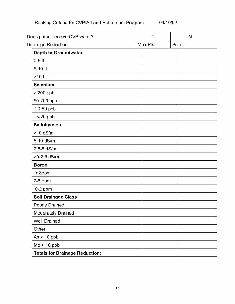
16
Ranking Criteria for CVPIA Land Retirement Program 04/10/02
Does parcel receive CVP water? Y N
Drainage Reduction Max Pts: Score
Depth to Groundwater0-5 ft.
5-10 ft.
>10 ft.
Selenium> 200 ppb
50-200 ppb
20-50 ppb
5-20 ppb
Salinity(e.c.)>10 dS/m
5-10 dS/m
2.5-5 dS/m
>0-2.5 dS/m
Boron > 8ppm
2-8 ppm
0-2 ppm
Soil Drainage ClassPoorly Drained
Moderately Drained
Well Drained
Other
As > 10 ppb
Mo > 10 ppb
Totals for Drainage Reduction:

17
Fish & Wildlife Max pts: Score:______Risk of Exposure to contaminated waters Active drain to SJR/pond
Potential drain to SJR/pond
No drains
Parcel Size
Parcel size
Parcel location
Parcel is within 1 mile of managed habitat
Parcel is between 1-5 miles of managed habitat
Parcel is located contiguous to river or perennial stream,or within its historical floodplainRetirement of parcel will assist in implementation ofcurrent habitat management/recovery/conservationplans (corridor concept)Geographic relationship of parcel to other parcels inapplicant poolParcel is >5 miles from urban development or high-usefacilitiesTotals for Fish & Wildlife Enhancement:
Acquisition of Water for CVPIA Purposes Max pts: ____ Score:_____Entire water district (assignment of water contract)Amount of water available for acquisitionTotals for Acquisition of Water:
TOTALSMaximum possible points
Applicant’s score

18
Instructions for using Ranking CriteriaDoes Parcel Receive CVP water? (Y/N) This is to document eligibility of parcel forthe land retirement program, per requirements of sect. 3408(h), CVPIA.
Drainage ReductionDepth to Groundwater taken from San Joaquin Valley Drainage Program Final Report,1990 dataset, or most current GIS dataSelenium--sameSalinity--sameBoron--sameSoil Drainage Class--obtained from NRCS.Other--As, Mo obtained from GIS dataset listed above
Fish & WildlifeRisk of Exposure to contaminated waters: in order to factor in the risk of contaminantexposure to wildlife from such things as selenium, arsenic, etc., we need to know thepathway of the drainage and irrigation tailwater and the ultimate destination of thesewaters.
Parcel Size: simply mutliply the acres available by 0.01, capped at 50 pts.
Parcel LocationParcel within 1 mile of managed habitat: managed habitat is defined as lands inpublic ownership or a private preserve, managed for native species
Parcel is between 1-5 miles: using definition of managed habitat, use GIS map tolocate proximity of parcel to other managed habitat.
Parcel is located contiguous to river or perennial stream, or within its historicalfloodplain: using GIS dataset and floodplain maps, determine location of parcel relativeto this criterion. Criterion is important because riparian habitat is rare.

19
Retirement of parcel will assist in implementation of current habitatmanagement/recovery/conservation plans (linkage concept): flexibility is neededhere to obtain parcels that are key linkages to complement other program efforts.Determination of parcel importance includes such things as threatened and endangeredspecies, and other wildlife values.
Geographic relationship of parcel to other parcels in applicant pool: Using GISmap, compare location of offered parcel to other parcels in the applicant pool,previously selected lands, managed public lands, etc. to form “linkages”, and largerblock sizes.
Parcel is >5 miles from urban development or high-use facilities: Urbandevelopment is defined as areas with populations of 20,000 or more. High-use facilitiesare defined as those that have created major land disturbance activities and areoperated on a daily or continual basis. Major land disturbance activities may includeborrow pits, sand and gravel operations, airports, freeway interchanges, etc.
Acquisition of Water for CVPIA Purposes:Entire water district (assignment of contract)--if able to purchase the entire waterdistrict, the purchaser assumes control of the water contract and can easily move waterelsewhere, such as to refuges, in accordance with CVPIA, section 3405(a)(1) and(2) water transfers. Assumption of the contract is of great benefit as it locks up a stablesupply of water (no allocation uncertainties), may reduce long-term operation andmaintenance costs and debt-load issues , which may improve water management andconservation in accordance with CVPIA, section 3405, Water Transfers, ImprovedWater Management and Conservation.
Amount of water available for acquisition: - multiply acre-feet offered by 0.01 peracre-foot.

20
G:\alemi\tc3030399.doc