teanaway community forest -...
TRANSCRIPT

Teanaway Community Forest
Management Plan
Third Draft – March 5, 2015
FOR REVIEW PURPOSES ONLY – SUBJECT TO CHANGE WITHOUT NOTICE
Washington Department of Natural Resources
Washington Department of Fish and Wildlife
Transmittal letter
Dear Teanaway Community Forest supporter:
We are pleased to present the management plan for the Teanaway Community Forest, as directed by the Legislature and Governor when they approved the historic Teanaway purchase in 2013.
The plan reflects the contributions of dozens of community members and interested parties from across the state, including members of the Teanaway Community Forest Advisory Committee; hundreds of residents who provided comments and suggestions at public meetings and online; and many employees of the Washington departments of Natural Resources and Fish & Wildlife who have worked on this project for more than a year.
The Community Forest is the first of its kind in Washington state. It represents a new model that will allow the state to partner with communities to conserve the forests they love and manage them to ensure the protection of the landscape’s environmental, economic, and social benefits. The Teanaway is a very special place, and its management as a Community Forest – with the active involvement of central Washington residents as well as conservationists and recreation enthusiasts from across the state – will help Washingtonians preserve and strengthen the values that make the Teanaway Community Forest unique.
The Teanaway also plays a critical role within the Yakima River Basin, as a source of water in a region where that resource is often scarce; as vital habitat for a wide variety of species; as a working landscape for grazing and forestry; and as a mecca for many types of recreation.
When lawmakers approved the Teanaway purchase, they gave clear direction for the management of the forest and the development of this management plan. Our agencies are working hard to carry out those directives, and we are confident this management plan meets both the letter of the law and the bipartisan spirit of conservation that motivated its passage.
We are especially pleased to acknowledge the contributions of the 20 members of the Community Forest Advisory Committee, who devoted long hours to sharing their perspectives as Teanaway neighbors and community residents, conservationists and lovers of all kinds of recreation. Our partnership with the community – and the extended community of Teanaway lovers – will ensure sound management of this forest well into the future.
We welcome your interest in this management plan and encourage your continued involvement in the management and operation of the Teanaway Community forest.
Peter Goldmark Jim Unsworth
Washington State Director Commissioner of Public Lands Washington Department of Fish and Wildlife
1
Table of Contents
Transmittal letter
Introduction to the Teanaway Community Forest
Chapter 1: Water Supply and watershed protection
Chapter 2: Working Lands – Grazing and Forestry
Chapter 3: Recreation
Chapter 4: Fish and Wildlife Habitat
Chapter 5: Community Partnership
Chapter 6 Implementation of the Management Plan
Appendices (available online, not included in this document)
Senate Bill 5367 – complete text of chapter law
Habitat and Working Lands Easement
Interagency agreement
SEPA documents
Yakima Basin Integrated Plan
2
Introduction to the Teanaway Community Forest
In 2013, Washington State paid $100 million to acquire 50,241 acres north of Cle Elum in Kittitas County for the Teanaway Community Forest. The purchase, from American Forest Holdings LLC, was the largest single land transaction by Washington State government in 45 years, resulting from more than a decade of collaboration by many people and organizations.
In authorizing the purchase, lawmakers directed the Department of Natural Resources (DNR) to manage the property as the first state-run community forest under the terms of 2011 legislation that emphasizes community participation in forest management.
The 2013 legislation that authorized the Teanaway purchase, Senate Bill 5367, also directed DNR to consult with the Department of Fish and Wildlife (WDFW) to establish a community-based advisory committee and to work with a wide range of constituent groups to develop a management plan for the forest by June 30, 2015. This plan will be in effect at least through 2025, subject to possible revision as forest conditions and circumstances change.
The community forest is a key element of the Yakima River Basin Integrated Water Resource Management Plan (known as the YBIP), and the YBIP principles for forest land acquisitions guided the design of the Community Forest management plan.
This plan was developed to meet the requirements of the law and to reflect the priorities of the Washingtonians who cherish the Teanaway. The plan signifies the commitment of DNR and WDFW to operate the Community Forest in an ongoing collaborative process with the Teanaway Community Forest Advisory Committee and the broader community of people and organizations who live, work, and play there.
Overview and history of the Teanaway
The Community Forest is located in the upper Yakima River Basin north of Interstate 90 and south of Mount Stuart.
The area’s climate features warm, dry summers and cold, wet winters. The geology is a mix of sedimentary sandstone deposits, volcanic basalts, metamorphic rocks, and glacial and river deposits. Home to a wide variety of fish and wildlife, the forest provides habitats ranging from a dry, pine-based, lowland forest to a wet, high-elevation, grand-fir based environment. Elk and mule deer live in the area year-round, and the forest includes important wintering and calving grounds. Other species, such as cougars, black bears, spotted owls, and one of the state’s gray wolf packs, also live in the forest.
The three forks of the Teanaway River join in the Community Forest and flow into the Yakima River. The Yakima River historically supported large numbers of salmon, steelhead, and bull trout, but populations declined steeply in the 20th century. The Teanaway system connects some of the highest quality streams and cold water fish-spawning and rearing areas in the Yakima Basin and is critical to the recovery of the Yakima River steelhead run. It also provides critical habitat for potential bull trout recovery. Recent restoration efforts have helped to increase the number of spring Chinook and steelhead in the Teanaway River.
3
Human occupation began at least 11,500 years ago. For many generations, Native Americans lived, hunted, fished, and gathered berries and plants in the Teanaway watershed. The watershed is within the ceded area of the Yakama Nation under the Treaty of 1855, and Yakama members continue to conduct their usual and accustomed practices within the Community Forest.
Farming, grazing, and timber harvest became important within the Teanaway watershed as European immigrants and other settlers began moving into the area in the late 1800s. Sheep and cattle grazing occurred on land that is now within the boundaries of the Community Forest. At various times, several thousand head of cattle grazed in the area. Timber harvest within the forest began early in the 1900s, and the Cascade Lumber Co. was formed in 1903 to take advantage of opportunities in and around the Teanaway.
Initially, operators would float logs down the river to the confluence with the Yakima. By 1916, Cascade Lumber had developed extensive rail lines and a town near the forks of the Teanaway River. With that infrastructure in place, railcars became the primary method of transport, which allowed for substantial amounts of timber to be harvested and shipped to mills in Yakima and elsewhere. Timber harvest has continued ever since, and most of the original forest has been harvested and replanted.
In 1957, Cascade combined with Boise Payette Lumber Co. to form Boise Cascade, which continued timber harvest in the area until 1999, when it sold the Teanaway property to American Forest Holdings LLC.
The Community Forest and the Yakima Basin Integrated Plan
The Yakima River Basin is one of the most diverse and ecologically rich areas in Washington. Its water supports growing communities, a vital agricultural industry, and many fish and wildlife species. But water shortages are a chronic problem. Demand consistently outstrips the supply needed to irrigate crops, to meet the needs of a growing population, and to rebuild depleted fish stocks. That is why watershed protection through targeted land acquisition is a key element of the Yakima River Basin Integrated Water Resource Management Plan.
The YBIP reflects years of work by a wide-ranging coalition of partners. In 2009, to address ongoing water shortages, the Washington Department of Ecology and the U.S. Bureau of Reclamation established a work group that included irrigation districts, environmental organizations, natural resource agencies, the Yakama Nation, counties, cities, and other interested people and groups to develop a consensus-based, long-term solution to the problem of inadequate water supplies. The work group produced the YBIP, a seven-part approach to resolving the water issue, and its associated environmental impact statement in 2012.
A key early step in the YBIP was the Teanaway acquisition. The state’s purchase preserved critically important land in the headwaters of the Yakima Basin, giving the state and its partners the opportunity to protect and enhance both the water supply and the watershed. In addition, the Teanaway offers opportunities to improve in-stream fish habitat, floodplains, and streamside vegetation and habitat in the headwaters of the basin, and to improve the regional economy through recreational uses and working landscapes. Restoration of fish-spawning and –rearing areas in the Teanaway River system will provide important cold-water habitat for fish and help to support the recovery of steelhead, spring Chinook salmon, and bull trout.
4
Legislative action establishing the Teanaway Community Forest
Funding for the Teanaway land purchase was provided in the 2013-15 state capital budget and represented a large share of the $137 million that was earmarked for initial implementation of the YBIP. The budget authorized $99,344,000 for DNR to purchase the 50,241-acre parcel, including $10 million in the form of a loan from the DNR real property replacement account. Lawmakers appropriated $1.06 million to DNR in the state operating budget for management expenses, including development of the management plan.
Lawmakers called for completion of the management plan by June 30, 2015, through a public process involving a community-based advisory committee and consultation with local residents and a wide range of interest groups described below. While the management plan was being developed, initial maintenance work, including road work and safety repairs, was guided by a joint DNR-WDFW approach to interim stewardship. The agencies also agreed to permit recreational activities that former forest owners had allowed, until the adoption of the formal management plan.
The Legislature provided clear management direction when it approved the Teanaway purchase. The 2013 “Yakima River Basin Resource Management” law (2SSB 5367, available online as an appendix to this plan) set the vision for the forest and authorized the state Board of Natural Resources to enroll the property as the Teanaway Community Forest under the Community Forest Trust Program.
The law states that the management plan “must ensure that the land is managed in a manner that is consistent with the Yakima Basin Integrated Plan principles for forest land acquisitions, including the following:
• “To protect and enhance the water supply and protect the watershed; • “To maintain working lands for forestry and grazing while protecting key watershed functions and aquatic habitat; • “To maintain and where possible expand recreational opportunities consistent with watershed protection, for
activities such as hiking, fishing, hunting, horseback riding, camping, birding, and snowmobiling; • “To conserve and restore vital habitat for fish, including steelhead, spring Chinook, and bull trout, and wildlife,
including deer, elk, large predators, and spotted owls; and • “To support a strong community partnership, in which the Yakama Nation, residents, business owners, local
governments, conservation groups, and others provide advice about ongoing land management.”
5
Sidebar: What is a Community Forest?
As Washington’s population grows, more suburban development occurs in previously forested areas, bumping up against the remaining working forests. As communities foster expectations that neighboring forests and their benefits will remain intact, it is more difficult to manage commercial forests for timber production, and it becomes more economical to convert them to uses other than working forests. Often, the community doesn’t recognize what they are losing until the forest next door is cleared for construction—perpetuating the process.
To address this, in 2011 the state Legislature and Department of Natural Resources (DNR) created a new tool for local community partners to participate in protecting working forestlands that benefit their communities—the Community Forest Trust. The Teanaway Community Forest is the first parcel in the state to be managed under this new authority.
DNR and legislators recognized that when lands are converted from forestry, the state loses the vital benefits they provide in the ecosystem—wildlife habitat, clean drinking water for people and salmon, clean air, carbon storage, and recreation. Conversion also puts local natural resource-based industries and jobs at risk, along with the ecological, financial, and social values these forests provide to the community.
The Community Forest Trust Program is founded upon the concept of communities working together with the state to preserve the forests they love.
End sidebar
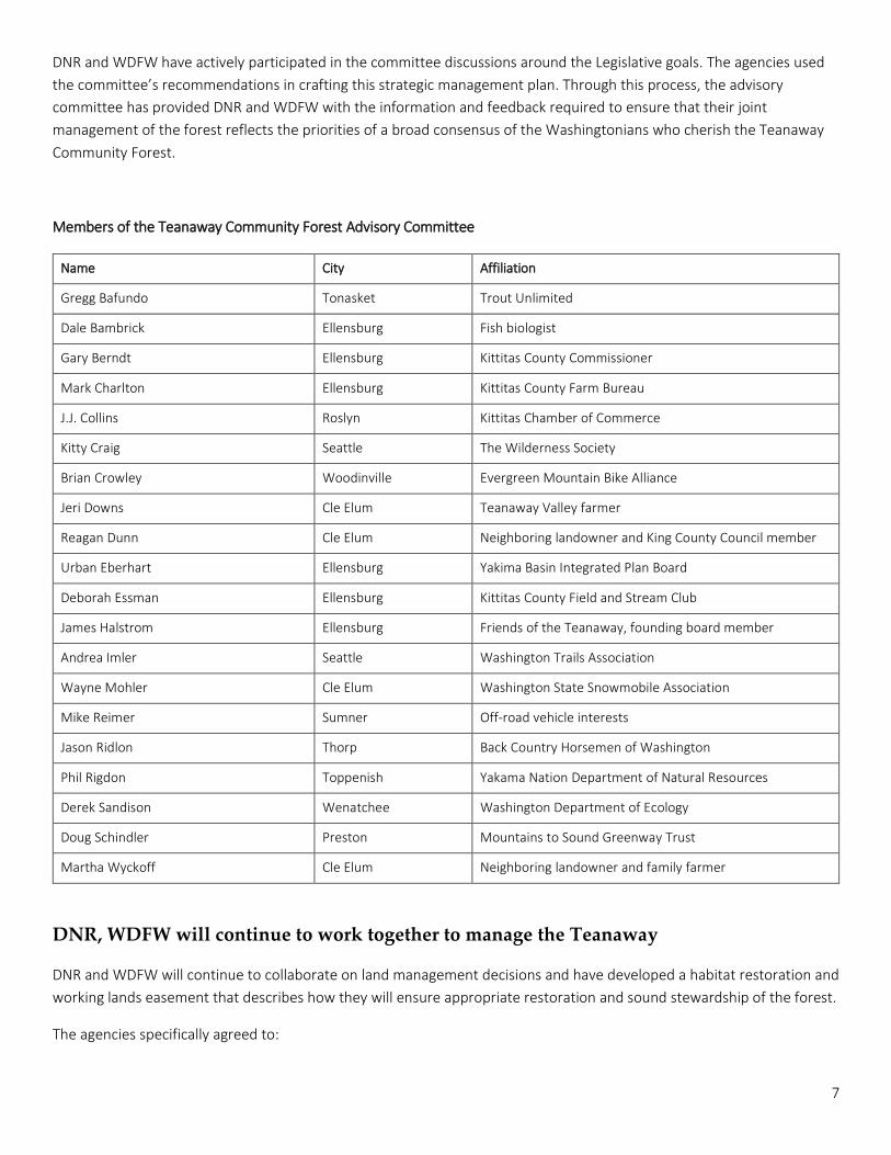
Teanaway Community Forest Advisory Committee
The law directed DNR, in consultation with WDFW, to establish a Teanaway Community Forest Advisory Committee with representation from the Washington Department of Ecology, the local community, land conservation organizations, the Yakama Nation, the Kittitas County Commission, and local agricultural interests. Further, it called for the management plan to be developed through a public process involving “interested stakeholders, particularly residents from Kittitas County, friends of the Teanaway, back country horsemen, off-road vehicle and snowmobile users, a representative from Kittitas field and stream, hikers and wildlife watchers, and ranchers who graze cattle.”
In January 2014, DNR and WDFW began the process of creating the Teanaway Community Forest management plan by selecting the members of the Advisory Committee, whose purpose is to provide DNR and WDFW with advice and recommendations for the management plan and subsequent ongoing management.
The advisory committee methodically considered the goals identified by the Legislature, learning about the forest, brainstorming ideas about how to achieve those goals, reviewing and revising draft objectives and strategies, and ultimately advising the agencies on all aspects of the management plan.
This process included 15 public committee meetings, three public open houses, and field trips into the forest designed to ensure that all members had a thorough understanding of the forest and related management issues. Ultimately, the agencies received more than 1,600 public comments, and all interested parties had multiple opportunities to provide comments and feedback.
6
DNR and WDFW have actively participated in the committee discussions around the Legislative goals. The agencies used the committee’s recommendations in crafting this strategic management plan. Through this process, the advisory committee has provided DNR and WDFW with the information and feedback required to ensure that their joint management of the forest reflects the priorities of a broad consensus of the Washingtonians who cherish the Teanaway Community Forest.
Members of the Teanaway Community Forest Advisory Committee
Name City Affiliation
Gregg Bafundo Tonasket Trout Unlimited
Dale Bambrick Ellensburg Fish biologist
Gary Berndt Ellensburg Kittitas County Commissioner
Mark Charlton Ellensburg Kittitas County Farm Bureau
J.J. Collins Roslyn Kittitas Chamber of Commerce
Kitty Craig Seattle The Wilderness Society
Brian Crowley Woodinville Evergreen Mountain Bike Alliance
Jeri Downs Cle Elum Teanaway Valley farmer
Reagan Dunn Cle Elum Neighboring landowner and King County Council member
Urban Eberhart Ellensburg Yakima Basin Integrated Plan Board
Deborah Essman Ellensburg Kittitas County Field and Stream Club
James Halstrom Ellensburg Friends of the Teanaway, founding board member
Andrea Imler Seattle Washington Trails Association
Wayne Mohler Cle Elum Washington State Snowmobile Association
Mike Reimer Sumner Off-road vehicle interests
Jason Ridlon Thorp Back Country Horsemen of Washington
Phil Rigdon Toppenish Yakama Nation Department of Natural Resources
Derek Sandison Wenatchee Washington Department of Ecology
Doug Schindler Preston Mountains to Sound Greenway Trust
Martha Wyckoff Cle Elum Neighboring landowner and family farmer
DNR, WDFW will continue to work together to manage the Teanaway
DNR and WDFW will continue to collaborate on land management decisions and have developed a habitat restoration and working lands easement that describes how they will ensure appropriate restoration and sound stewardship of the forest.
The agencies specifically agreed to:
7
• Fully, equally, and collaboratively share the land management responsibilities for the Teanaway Community Forest based on the principle of joint-decision making.
• Manage the forest in a manner that helps Washington State achieve the goals of the Yakima Basin Integrated Plan and builds on the strong stakeholder partnerships that have formed around the YBIP and the Community Forest.
• Jointly select restoration projects and develop performance standards to determine the projects’ effectiveness. • Place a top priority on projects affecting endangered or threatened species under the U.S. Endangered Species
Act. • Allow timber management, removal of minor forest products, and livestock grazing, subject to the provisions of
the management plan. • Manage recreational activities to protect key watershed functions and aquatic habitat.
SIDEBAR – About this document
This management plan is organized to reflect the legislative priorities for the Community Forest, with separate chapters on each of the goals in the legislation: watershed and water quality issues, forestry and grazing, recreation, fish and wildlife habitat, and community partnerships. Those chapters include:
• An overview of the goal and brief discussion of the current condition of the forest;
• The perspectives of the members of the Advisory Committee;
• Objectives, strategies, and tools for achieving the specific goal; and
• Performance measures that will be used to track progress toward the objectives.
Issues that cut across the primary subjects, such as road management and law enforcement, are discussed in multiple locations in the report as appropriate.
Appendices to the management plan are available online and include the full text of 2SSB 5367, which authorized the forest; the habitat restoration and working lands easement granted to WDFW for work in the forest; the agreement between DNR and WDFW that details the agencies’ collaborative Teanaway management process; and documents published to meet the requirements of the State Environmental Policy Act for the management plan.
End sidebar
8
Chapter 1: Water supply and watershed protection
Goal 1: “To protect and enhance the water supply and protect the watershed”
The Teanaway Community Forest contains approximately one-third of the Teanaway River watershed. Nearly 400 miles of free-flowing streams and rivers join together in the forest to form the main stem Teanaway River, which flows on to the Yakima River.
Water demand in the Yakima River basin exceeds supply, and demand is still rising due to population growth and continuing agricultural use. By protecting the water in the Teanaway Community Forest from future development, the Yakima Basin Integrated Plan seeks to ensure the river can provide in-stream flows for fish and the water can continue downstream to supply agriculture and urban uses. However, the amount of water flowing through the Teanaway River watershed drops during the dry summer months, often disconnecting streams and adversely affecting vital fish habitat. In addition, more runoff is occurring earlier in the year than it did historically in the watershed. Eroded stream banks, high levels of sediment and a lack of streamside vegetation also affect portions of the Teanaway watershed.
Restoring natural floodplain functions will slow runoff and increase water storage, making more water available in the summer, when demand intensifies. More water flowing through the Teanaway watershed later in the year also will benefit fish.
The road network in the community forest has the potential to affect water supply and watershed health as well as other management objectives. Roads can damage fish habitat by contributing sediment to streams or can restrict interaction between a stream and its floodplain. However, access to the forest for recreation and forest management requires an efficient road network. After assuming ownership of the forest lands in 2013, the departments surveyed the road system to understand the extent and condition of roads, culverts, and bridges. They found a widespread, yet aging, road network that is damaging fish habitat in some locations. The steps outlined in the strategies section describe a process for improving watershed health by removing unneeded roads and upgrading others while providing access for recreation, timber harvest and grazing.
Advisory Committee input
The advisory committee brainstormed approaches to meet the Legislature’s directive for water supply and watershed protection. The committee’s dialogue provided the central ideas for the objectives, strategies, and tools. The committee generally agreed on the importance of a restored and properly functioning watershed.
Committee members place a high priority on actions to restore streams and reconnect them to floodplains and groundwater. Overall, the forest and meadows of the Teanaway Community Forest should act like a sponge, storing water during the winter and spring as snow or in the groundwater, and then releasing it slowly through the summer and fall as cold, clean, base flows. To accomplish this, restoration will be necessary on many streams and floodplains, including the use of beavers and large woody debris.
Stream restoration efforts will be aimed at reducing runoff and sediment from hardened or impervious surfaces, like roads, and from poorly vegetated hillsides, which can occur following severe fires. The advisory committee was particularly concerned about the negative effect of roads on the watershed. The committee recommended strategies to remove roads from floodplains and make road densities more appropriate to the watershed protection goal.
9
Objectives
• Conserve and restore the Teanaway watershed to facilitate the natural functioning of its streams, rivers, and floodplains.
• Manage the watershed to reduce peak flows, increase late season base flows, and decrease summertime water temperatures.
• Minimize damage to the watershed and habitat by ensuring that road and trail networks are appropriate in size and location.
• Manage water rights in a manner that preserves the watershed values of the Community Forest and is consistent with the Yakima Basin Integrated Plan.
Strategies
Increase the water storage capacity of forests, meadows, and floodplains.
• Use large woody debris or other approaches as appropriate in streams and floodplains to capture sediment to achieve a more natural stream channel and reconnect streams to their floodplains.
• Consider reintroducing beavers to encourage the impoundment of surface and ground water. • Prioritize stream reaches that provide the most benefit to steelhead, spring Chinook and bull trout, have the
greatest potential for fish production, and help achieve other objectives. • Use practices such as forest thinning or gap creation to increase the capture and retention of snowpack. • Create forest conditions in which precipitation and runoff is captured and retained by the forest floor.
Minimize runoff from uplands and timber harvest practices.
• Use low-impact timber harvest techniques such as over-the-snow logging, cable systems, low-pressure ground equipment, the use of helicopters and harvesting when soils are dry to reduce soil compaction and minimize sediment delivery to streams. Conduct these practices whenever forest harvest occurs. Restore areas where past forest practices have led to problems.
• Conduct forest management operations to reduce the risk of high-severity, stand-replacing fires, that increase erosion and reduce the capacity of the forest to store runoff. Use methods such as mechanical thinning, hand thinning, or others as appropriate. Focus this strategy in areas where fuel loads are high, that are in areas that have a higher risk of ignition, and that help achieve other objectives.
Improve the function of riparian areas, wetlands, and meadows.
• Protect and restore riparian areas to support a mature riparian buffer that contains an appropriate mix of trees, shrubs, and grasses.
• Ensure that the riparian areas of smaller streams are protected, restored, or enhanced during forestry operations. Consider restoration through plantings if appropriate to the site.
• Focus protection and restoration efforts in priority stream reaches that show the best chances for success. • Protect and restore meadows and wetlands by allowing water to flow over and through those areas. • Redesign, relocate, or remove roads, trails and other features that harm riparian areas, wetlands or meadows.
Reduce soil compaction from grazing or other activities on these sites. Restore sites that have been damaged. • Minimize the damage of grazing, timber harvest, and other activities on riparian areas and stream zones. Use
tools such as range riders, salt blocks, low-moisture blocks, off-site water improvements, fencing, or natural barriers to draw cattle away from riparian areas and sensitive stream banks. Protect recently restored riparian areas until they are resilient enough to withstand grazing or other activities, continuing to monitor these areas.
Develop a sustainable road and trail system that minimizes damage to water quality, fish and wildlife habitat and the watershed while still taking into account the needs of forest users.
10
• Assess the road network. Categorize and identify locations for roads based upon their future purpose: Roads that are needed for forest management, grazing management, recreation, public access or have an easement by another entity; roads that do not have a purpose, or provide duplicative access and can be decommissioned.
• Evaluate how each road affects water quality, watershed function, and fish and wildlife habitat. Prioritize roads that do the most harm for decommissioning, repair, relocation or realignment. Maintain roads with an identifiable forest management purpose if the potential damage these roads cause can be mitigated by improvements. Roads that have a purpose but also harm water quality, the watershed or fish habitat will be further evaluated based on the criteria below.
• Determine the appropriate tool – based on the potential harm of the road, purpose of the road and available funding – to minimize damage that can be caused by the road. Tools include road improvements, relocation, conversion to trails, and abandonment/decommissioning.
• Determine if additional roads are needed to meet a management need. Build new roads only if they will have minimal impact on water quality, watershed function, and fish and wildlife habitat.
• Monitor results and repeat these steps as necessary to meet the objective. • Consider the use of seasonal or permanent road closures to reduce harm to water quality. • Work with neighbors and partners when assessing and evaluating the road system. • Ensure roads are maintained to a high standard. • Work with partners to find funds for road projects.
DNR and WDFW will use the following criteria to lease the water rights associated with the Community Forest:
• Water Rights associated with the Community Forest shall not be permanently sold. All use of the water shall first prioritize restoration of the forest, fish habitat and appropriate uses therein. They may be leased for use by others as follows: “Back-mitigation” for domestic or agricultural use in the greater Yakima Basin or temporary drought mitigation. The water right will not be used to support any new development in either the Teanaway or the greater Yakima River Basin.
• Advisory Committee Support: As in all TCF management issues, the Advisory Committee consensus is not required but highly desirable.
• Legal Risk: The proposal must be able to demonstrate low political and legal risk. These two types of risk must be specifically addressed by a proposal since we are aware that both types of risk exist currently in the world of water banks in Kittitas County.
• Fair Market Value: Any proposal must adhere to good business practices including a fair market value assessment.
• Support of other YBIP Partners/Water Users: It would be advisable for the proposal to have the support of the Washington Department of Ecology, Yakama Nation, Bureau of Reclamation, and other major water users. The Water Transfer Working Group appears to be a meaningful vehicle for obtaining that review and support.
• Yakima Basin Integrated Plan (YBIP) Goals: The proposal must be consistent with the goals of the YBIP. Mitigating for existing unmitigated wells would be a viable use of water, in the context of an otherwise supportable proposal.
• Benefit(s) to the TCF: Long-term benefit to the TCF is an essential element of any successful proposal. This means addressing an overriding concern about ongoing stewardship resources such as revenue for the Community Forest Trust. This issue was a strong concern of all parties involved in the purchase of the Teanaway and was specifically called out in the YBIP Watershed Lands Subcommittee Report. Proposals that directly address that long-term need will be favored over short-term proposals. The agencies will be looking at any proposal through the lens of long-term economic benefit to the TCF (i.e., potable water for campgrounds, revenue generation for stewardship of the forest).
11
• Combined TCF/YBIP Benefits: Ensuring that the TCF achieves its role in the YBIP is essential to the success of a proposal. Use of the water that directly meets the resource goals of the YBIP and provides long-term, ongoing benefits back to the TCF is desirable.
• Opportunity Costs: Any proposal must address not only the opportunities but the costs of the proposal and how it will provide compensation for lost opportunities as a result of it being implemented.
• Any future use of the water inside the community forest shall not reduce late-season base flows for fish. Uses for restoration purposes shall not exceed three years without justification and shall focus on early-season withdrawals.
• Any future use outside of the community forest must ensure that no water goes to projects that damage aquatic habitat, such as developments in the floodplain, and must be as efficient as possible.
• Any future use shall meet the requirements of the state’s water code, such as proper fish screens.
Measuring Progress
Water temperature and flows
Priority Actions • Determine baseline conditions for water temperature and flows by February 2016. • Design and establish monitoring protocols to track changes for water temperature and flows at the watershed
scale and project level scale by April 2016. Performance measures
• Base flow increases in late summer to early autumn. • Summer-time base flow water temperature decreases.
Water: Sediment and Fish Barriers Contributed by Roads, Trails, and Infrastructure
Priority Actions
• Conduct a road survey by February 2016 to evaluate forest roads and assess whether they meet forest practice rule standards.
• Conduct an analysis of the Teanaway road and trail network to determine the amount of sediment delivery to streams using the Washington Roads Sediment Model by February 2016.
• Determine where road access is a high priority for management and recreation users by March 2016. • Develop an assessment tool to identify priority projects by April 2016. Update and run the assessment tool again
as projects are completed and new information becomes available. • Develop a work plan to implement the highest priority projects by May 2016. • Remove fish passage barriers as required under state forest practice rules by September 2021. • Complete sediment delivery projects as required under state forest practice rules by September 2021.
Performance measures
• Number of fish passage barriers removed. • Linear feet of stream opened to fish movement. • Number of improvements applied (surfacing, crossings, traffic controls, drainage, vegetation, road
decommission/abandonment, etc.). • Number of culverts removed, replaced or newly installed.
12
• The amount of sediment delivered to streams as identified by the Washington Roads Sediment Model.
Fragmentation of floodplains and wetlands by roads, trails, and infrastructure
Priority actions
• Organize partners interested in floodplain and wetland restoration by February 2016. • Determine where roads, trails, and infrastructure disrupt stream channel migration by February 2016. • Determine where roads, trails, and infrastructure have reduced the ability of wetlands to hold, filter, and release
water by February 2016. • Develop a work schedule to implement the highest priority projects to realign or decommission roads by May
2016. • Develop a work schedule to implement the highest priority trail realignment, improvement, or abandonment
projects by May 2016.
Performance measures
• Number of sections of roads abandoned or realigned out of floodplains or wetlands. • Number of sections of trails realigned, improved, or abandoned out of floodplains or wetlands. • Number of roads, trails and infrastructure that impede natural stream migration or wetland function.
13
Chapter 2: Working Lands
Goal 2: “To maintain working lands for forestry and grazing while protecting key watershed functions and aquatic habitat.”
The term “working lands” refers to landscapes that have land uses such as timber harvest, grazing, farming or mining. The intent of a working landscape is to make productive economic use of lands on a sustainable basis depending on society’s desires. In the enabling legislation, the Legislature exempted the Teanaway Community Forest from a requirement to generate income to fund operations, but allowed for limited historical uses such as forestry and grazing to continue.
The Yakima Basin Integrated Plan directs that the lands acquired for habitat restoration and watershed enhancement should continue to allow historic uses if compatible with those purposes. These directives allow the agencies to focus attention on sustainable practices designed to promote watershed health and habitat for fish and wildlife.
This goal is divided into two sections: one for forests, and one for grazing.
Working Forests
Historically, the forest of the Teanaway watershed was a mosaic of open spaces, ponderosa pine, Douglas fir, grand fir western larch and other tree species. Disturbances such as wildfires, insect infestations, and diseases thinned tree densities and left a distribution of small clearings within clumps of large, old trees in the overstory and younger trees in the understory. Over the years, and particularly in the past century, timber harvesting, grazing, and the suppression of natural fires have altered the forest’s species composition, density and structure. Today, the forest has a high density of trees susceptible to insects and disease, and fewer large, old trees than it previously did.
Outbreaks of insects – such as the western spruce budworm, which feeds predominately on fir trees – have attacked many trees in the watershed over the last decade. As trees are killed by insects, both the risk and potential severity of wildfires increase. Although fire plays a role in the natural ecosystem, catastrophic fire can pose a threat to water quality, fish and wildlife habitat, and neighboring communities. Levels of western spruce budworm infestation in the older tree stands of the Teanaway watershed are alarming and pose a serious threat to the long-term health and productivity of the forest.
Healthy fish and wildlife habitat, functioning streams and sustainable timber harvests are possible under an active management plan that also would reduce the risk of fire and insect outbreaks.
Advisory Committee input for working forests
The advisory committee brainstormed approaches to achieving the goal and their dialogue provided the central ideas that formed the objectives, strategies, and tools. One theme to emerge is that efforts to improve forest health should guide forest management decisions and that sustainable timber harvest practices should be used to improve fish and wildlife habitat and protect the watershed. A viable economy should result from a sustainable timber harvest as the agencies manage the forest to reduce the risk of insect infestations, disease, and catastrophic fire. The agencies should advocate for coordination and consistency in forest management practices between neighbors to achieve landscape-scale ecosystem benefits.
14
Objectives for working forests
• Actively manage the forest to provide habitat for a diversity of fish and wildlife species, improve forest health and maintain watershed health.
• Harvest timber in ways that improve fish and wildlife habitat while generating revenue to help support the community forest.
• The agencies should engage with neighboring land owners and advocate for practices that reduce the risk of catastrophic fire or uncharacteristic insect and disease outbreaks, and connect wildlife habitat across the landscape.
• The road system within the forest should be efficient, sustainable, and support forest management activities. Strategies for working forests
Determine which forest-plant associations may be grown, managed, and sustained over time throughout the community forest.
• Identify suitable plant and tree species that may be grown throughout the Teanaway Community Forest, using soils, site productivity, slope, aspect, disturbance history, and climate.
• To understand current conditions, inventory the forest and collect data such as tree species, tree sizes, canopy cover and tree densities.
• Use this data to develop silvicultural prescriptions that restores the forest vegetation to a condition that is resilient to disturbances, provides a diversity of habitat, and provides a consistent flow of timber.
Provide diverse habitats across the landscape through active management.
• In areas capable of maintaining mature, grand fir forest habitat suitable for species such as the northern spotted owl: Develop a plan to restore and manage northern spotted owl habitat across the forest rather than on a circle-by-circle basis. a. Determine where owl habitat (nesting, roosting, and foraging habitat) can be grown and sustained. b. Restore northern spotted owl habitat by promoting the growth of mature or old forest areas. c. Maintain at least 50 percent of the acres identified as suitable for northern spotted owl habitat in habitat as
defined by state forest practice rules. d. Maintain appropriate levels of large, live trees, standing dead trees, and large woody debris to reduce the
forest’s vulnerability to insects, diseases, and wildfire. e. Initial focus on maintaining and increasing habitat that is adjacent to documented owl sites before expanding
to other sites. • Maintain open ponderosa pine and Douglas fir forest habitat suitable for species that live in open forests.
a. Determine where open forest types can be grown and sustained. b. Use an active management approach to create open stands where site conditions are best suited to support
these species and densities. Use silviculture tools to help achieve the habitat objective. • Once the fuel load is reduced and species composition and stocking levels are appropriate for the site, prescribed
fire may be used as a maintenance tool when and where appropriate and consistent with the objectives for the community forest.
Increase the quality and quantity of habitat across the landscape.
• Long term forest management practices should be developed, modeled to meet objectives, and used to guide decisions on harvest and other forest management operations.
• Leave appropriate levels of snags, downed woody debris, and large live trees that increase the quality of the habitat.
15
• Develop harvest schedules based primarily on healthy forest habitat objectives, and secondarily, for a reliable source of wood products.
Enhance the snowpack retention capacity of the forest.
• Use techniques such as thinning, gap creation, or other appropriate methods to allow more snow to reach the ground.
• Focus snowpack retention on the areas consistent with other objectives for fish and wildlife, fire, and insects and disease.
Reduce the rate of runoff from rain-on-snow events.
• Reduce runoff and erosion from rain-on-snow events by creating conditions where the forest vegetation and forest floor will slow down and absorb runoff.
Manage the forest to reduce the risk and severity of fire near infrastructure and sensitive fish and wildlife areas.
• Assess the risk and potential severity of fire across the forest. • Implement fuels reduction projects to reduce the risk or severity of fire.
Work with neighboring landowners and partners to address forest health and habitat issues across ownership boundaries.
• Work within the Tapash Sustainable Forest Collaborative and other organizations to identify and implement projects that reduce uncharacteristically severe fire and insect outbreaks.
• Work with neighboring landowners and agencies to improve landscape-scale fish and wildlife connectivity. a. Identify locations and actions to improve habitat connectivity with neighboring landowners. Advocate for
neighboring land management that will improve habitat connectivity. Identify further analyses to be done. b. Engage with neighbors about the importance of increasing habitat for northern spotted owls.
Measuring performance for working forests
Forest habitat improvements
Priority Actions
• Develop a short-term forest management activity schedule by May 2016. Identify immediate restoration needs based upon the current inventory of forest habitat.
• Develop a long-term forest management activity schedule by May 2018 to provide habitat for diverse species. a. Conduct a forest inventory to determine the current structure and condition of the forest. b. Identify potential distribution of future forest habitats. c. Develop a long-term restoration schedule to improve forest conditions by modifying the structure and
composition of the forest. • By 2019, identify sub-watershed basins where tree age and density do not meet desired conditions to reduce the
rate of runoff from rain-on-snow events.
Performance measures
• Number of acres of forest treated to enhance watershed protection, forest health, fish and wildlife habitat. • Increase in the percentage of forest land that contains the appropriate mix of vegetation for long-term forest
health. • Net revenue generated by the sale of timber and wood products to improve forest stewardship. • Increase the number of watersheds that reduce the rate of runoff from rain-on-snow events.
16
Forest fire risk reduction
Priority actions
• Begin the assessment of fire risk during the summer of 2015 and complete it by May 2016. • Evaluate ignition probability, fuel loads, and location of valued resources (such as infrastructure and sensitive fish
and wildlife areas). • Identify priority projects to reduce the risk of damage to valued resources. • Develop a work plan of management actions to implement priority projects by June 2016. Continue to re-assess
and re-evaluate as projects are completed and new data becomes available.
Performance measures
• Number of acres of forest treated to enhance watershed protection and forest health. • Reduction in risk of high-severity fires that could damage valued resources.
Grazing
The lands of the Teanaway Community Forest have supported domestic livestock operations since the late 19th century. The Legislature intended this historic use to continue while also protecting watershed health and fish habitat.
Historically, both cattle and sheep grazed the Teanaway watershed in large numbers. The intensity of grazing has slowly declined over the past century. By 2015, only three operators were using forest lands, moving cattle into the area in June and removing them in October.
Poorly managed grazing can harm the watershed and fish and wildlife habitat when livestock are allowed to tread through streams and riparian areas. Given the potential for resource damage, grazing in the community forest will be held to a high standard of sustainability with respect to watershed protection, riparian protection, water quality, and fish and wildlife habitat.
Advisory committee input
Advisory committee members had diverse opinions regarding grazing practices on the forest. A number of committee members viewed grazing as a community benefit and wanted to support local ranchers to ensure the historic practice can continue into the future. Others supported grazing only at levels that will not impede recovery of fish habitat, riparian vegetation and water quality and wanted assurances that appropriate steps will be taken to ensure compatibility. The committee agreed that there should be a high standard imposed to protect floodplains, riparian areas, fish and wildlife habitat and water quality.
Objectives for grazing
• Manage domestic livestock grazing to maintain or improve fish and wildlife habitat. • Ensure measures are in place to accommodate grazing and protect watershed health. • Restore riparian areas and meadows that have been damaged by domestic livestock grazing. • Provide opportunities for livestock to graze in locations other than meadows and riparian areas.
17
Strategies for grazing
Adjust the timing, duration, frequency, and location of grazing to be consistent with meadow and riparian restoration.
• Control domestic livestock grazing patterns and pressure with herd numbers, hardened crossings, off-site water, salt and low-moisture molasses blocks, range riders, grouping of herds, natural barriers, and fencing to improve upland livestock distribution and direct livestock away from riparian and stream zones.
• Use these practices to limit livestock access in areas where habitat restoration is occurring or has recently occurred and needs ongoing protection. Also employ these techniques to minimize potential damage to riparian areas, stream banks, and fish spawning habitat.
Develop and implement a monitoring program that facilitates adaptive management.
• Use an interdisciplinary team to develop and implement a monitoring program. • Monitoring will be designed to detect short-term damage and long-term changes to riparian and upland habitats,
stream-bank stability, and vegetation composition. It will be repeatable and responsive to management needs, and reflect the best available science.
Implement range infrastructure projects to ensure no damage occurs to water quality, fish and wildlife habitat.
• Work with partners and lessees to fund, design, and implement range infrastructure projects, such as off-site watering areas, low-moisture molasses blocks, fencing, and other barriers.
• Locate, design, and implement stream crossings and stream access points in appropriate places to protect fish habitat, especially spawning areas.
• Work with leaseholders and other interested parties to remove excess or unneeded fencing. Minimize conflict between domestic livestock and wildlife.
• Work with partners and lessees to design, fund, and implement practices to minimize depredation on livestock herds.
Ensure a sustainable grazing program.
• Consider the benefits of grazing multiple or various species, such as sheep and/or goats in addition to cattle. • Ensure that grazing leases make tenant responsibilities explicit and facilitate adaptive management.
Measuring progress for grazing
Priority actions
• Develop a schedule for sustainable domestic livestock grazing by March 2016. • Use an interagency and interdisciplinary team to develop a rangeland and riparian adaptive management
program that includes steps on monitoring for impacts and making changes to practices by March 2016. The program will monitor both Teanaway forest-wide and site-specific conditions including priority streams, restoration sites, and turnout and gathering sites.
a. Conduct annual surveys on stream bank alteration, riparian vegetation, and upland and meadow condition within select areas and along priority streams.
b. Inventory livestock stream crossings and determine if these are proximate to historic salmonid spawning grounds or suitable spawning habitat by October 2016.
18
c. Inventory existing range improvements and determine the need for additional improvements in order to protect watershed health and improve rangeland health by October 2016.
d. Survey existing fences and assess their suitability and need for current management by October 2016. • Implement range improvement projects to protect watershed health and fish and wildlife habitat and improve
rangeland health by May 2016. Continue to monitor to determine if additional actions are needed. • Locate appropriate stream crossing sites by March 2017. Monitor to determine if inappropriate crossings are
being used and restore those areas.
Performance measures
• Number of stream crossings removed, relocated, or improved. • Number of range infrastructure improvements added (off-channel watering sites, low-moisture molasses blocks,
exclusion zones, etc.). • Linear feet of fencing (and other infrastructure) removed or added. • Number and type of projects to protect aquatic, riparian, and wetland habitat. • Number of documented wildlife-domestic livestock conflicts • Acres within riparian areas and meadows restored to address damage from domestic livestock grazing. • Acres provided for livestock grazing away from meadows and riparian areas.
19
Chapter 3 – Recreation
Goal 3: “To maintain and where possible expand recreational opportunities consistent with watershed protection, for activities such as hiking, fishing, hunting, horseback riding, camping, birding, and snowmobiling”
Overview
Recreational opportunities abound in the Community Forest. Hikers, mountain bikers and horseback riders flock to the forest to take in views of the Teanaway valley and its scenic landscape. The area’s wildlife and fish draw hunters and anglers as well as photographers, hikers, birders and other wildlife watchers. Three campgrounds are busy for much of the year, and groomed trails attract snowmobilers in winter. Several roads and trails in the community forest connect to trails in the adjacent Okanogan-Wenatchee National Forest, which offer opportunities for motorized and non-motorized recreation. The forest and its rivers are very popular day-use destinations for the local community.
The Legislature’s direction to DNR and WDFW reflects the Teanaway’s history as a prime recreation area – and its importance as a source of water and fish habitat in the Yakima Basin. Likewise, the Yakima Basin Integrated Water Resource Management Plan (YBIP) recognizes that lands acquired for watershed protection and habitat conservation can support well-managed recreation activities. Ultimately, recreation in the Teanaway Community Forest must be consistent with watershed protection and the other forest objectives.
In the past, visitors recreating in the forest took advantage of the 334 miles of roads built for forest management by previous property owners. Use of these roads, which also provided access to the Teanaway backcountry, was controlled by gates, earthen barricades, and berms. Motorcycles have used – and may still use -- three authorized trails in the Community Forest to reach multi-use trails in the nearby national forest. Other off-road vehicle (ORV) use was not allowed by the former owners and is not currently permitted, although unsanctioned ORV use has occurred.
Today, numerous unapproved, user-made trails crisscross the community forest, sometimes cutting though vital wildlife habitat or running alongside or through streams. Use of such trails -- for motorized and some forms of non-motorized recreation -- can harm habitat and water quality. Proper trail design and placement will be an important future management activity.
Advisory Committee Input
The Advisory Committee agreed on many of the themes associated with recreational use of the forest, including the need to develop a recreation plan that ensures watershed protection and forest sustainability. Committee members recognize the strong desire in the local community and across the state for recreation opportunities in the Community Forest, and they urged DNR and WDFW to provide a variety of opportunities to diverse user groups.
They said recreational opportunities should be developed with the participation of recreation groups and advisory committee members, that recreation be managed to maximize compatibility among different forms of recreation, that private property rights be respected, and that recreation management stress consistency with watershed protection and the other goals in this plan. Committee members wanted to see trails developed to scenic locations, public access to rivers, and roads for recreational drivers. The committee also supports preserving winter access for activities such as snowmobiling, snowshoeing, and cross-country skiing.
20
The Advisory Committee agreed that recreation contributes to the economic vitality of the region, that recreation volunteers can help build and maintain trails and facilities, that facilities like campgrounds should provide a rustic yet pleasant camping experience, and that education and enforcement should be well-coordinated. However, opinions diverged on the topic of motorized recreation. Many committee members trusted that the recreation planning process would evaluate whether the forest could sustain such use while still achieving lawmakers’ goals for protecting watershed functions and fish and wildlife habitat. Some committee members support motorized recreation, while others believe motorized recreation, except for snowmobiling during the winter, would be incompatible with the Community Forest goals.
The committee recommended that the recreation plan should analyze if and where motorized use should occur in the forest and provided criteria to help guide recreation planning.
Agencies and Advisory Committee agree more recreation planning needed
As the two agencies and the Advisory Committee considered recreation management options through the summer and fall of 2014 – and as various recreation interests shared their frequently opposing views – it became clear that additional planning would be required to ensure appropriate and well-managed recreation in the Community Forest.
For that reason, this plan lays out the criteria and process needed for future planning and the objectives and strategies for recreation that will help guide the planning process. Future planning will take advantage of recreation strategies identified during the development of the management plan.
The Teanaway recreation planning process will reflect several factors, which differ in some respects from the standard DNR recreation planning process:
• The Legislature provided strong guidance for all land uses, including recreation, to be consistent with watershed protection;
• The recreation plan will need to recognize the broader role of the Community Forest in supporting watershed protection, fish restoration, and other objective of the Yakima Basin Integrated Plan.
• The recreation planning process will be guided by strong requirements for watershed protection and fish and wildlife habitat restoration as described in this management plan;
• Recreation planning for the Community Forest will receive significant interest and input from the conservation and recreational user groups that participated in developing the management plan; and
• The recreation planning committee will be composed of members of the Advisory Committee.
While the plan is being developed, recreation in the Community Forest will be guided by the interim rules that appear on the DNR website (http://www.teanaway.wa.gov). The Discover Pass will be required beginning January 1, 2016. State law requires the use of the Discover Pass on state lands. Adopting the Discover Pass will also allow for a law enforcement presence in the event that no other funding sources are available.
More information about recreation in the Community Forest is available from the DNR Southeast Region office in Ellensburg, 509-925-8510.
Recreation objectives
• Provide opportunities for recreational use of the Community Forest consistent with watershed protection. • Consider social as well as physical and biological factors in determining which recreation opportunities are
appropriate in the Community Forest and where those activities should take place.
21
• Identify opportunities for partner organizations and volunteers to help develop and maintain recreational facilities and assist with recreation management.
• Ensure that improvements to campgrounds and other recreation facilities meet users’ needs, protect public health and safety, and contribute to achieving other Community Forest goals.
Recreation strategies
Provide a sustainable network of safe, enjoyable recreational trails
Designate non-motorized trails for hikers, mountain bikers, horseback riders and others that:
• Emphasize scenic destinations and high-quality experiences. • Accommodate multiple skill levels, be designed as loop trails when appropriate, and connect to U.S. Forest
Service trails and the regional trail system. • Provide separate trails for specialized uses as appropriate to enhance users’ experiences and safety.
Provide winter trails for snowmobiles, cross-country skiing, and snowshoeing that:
• When practical, provide loop routes and connections to regional snowmobile trails. • Are designed, maintained, and, if necessary, relocated to protect water and fish and wildlife. • Include groomed and un-groomed snowmobile trails and ski trails. • Include marked, un-groomed trails for cross-country skiing and snowshoeing, with access points that connect to
regional snowshoe and cross-country ski trails.
All trail systems will be managed to protect water, fish and wildlife habitat, working lands, and other valued resources. DNR and WDFW, with volunteer help when appropriate, shall work to:
• Restore damaged areas, such as unauthorized trails. • Enforce access and natural resource laws and regulations. • Upgrade, mitigate for, relocate, or decommission trails and trail segments that are identified in the recreation
plan as unsafe or that harm water quality, are difficult to maintain, have highly erodible soils or steep slopes, or cut through sensitive wildlife habitat.
• Inform forest visitors about what they can do to protect the Community Forest environment.
DNR and WDFW will work closely with the USFS, The Nature Conservancy, local communities, and other neighbors to evaluate and resolve issues such as access, trail use, and enforcement across parcels owned by different organizations. Provide recreation opportunities and facilities that are consistent with watershed protection
The recreation plan will guide the efforts of forest managers to:
• Develop new and renovate existing trailheads, including interpretive signs and parking facilities, to ensure recreational access and minimize environmental damage. Where appropriate, new winter parking areas will be established.
• Provide rustic camping experiences while improving existing campgrounds to protect public health and safety, and fish and wildlife habitat.
• Designate day-use areas with parking facilities, including parking for walk-in fishing and hunting. • Allow for walk-in/pack-in backcountry camping away from heavily used areas. • Prohibit camping along county roads and other open roads within the forest. • Design water access sites to minimize the impact of recreation on fish and wildlife habitat. • Provide recreation access for people with disabilities as required by federal and state laws.
22
• Permit organized events and large group activities. Considerations will include safety, capacity for participants, staffing needs, sanitation requirements, and the needs and priorities of private property-owners within and adjacent to the forest.
• Determine how to manage and, if necessary limit commercial recreational activities in the forest. • Provide designated firewood collection areas.
Maintain existing partnerships and establish new collaborations between public agencies, user groups, and citizen volunteers
• Partner with volunteer groups and non-profit organizations, community groups, and recreation clubs to educate the public and to maintain and restore the forest.
• Develop partnerships with local communities and adjacent public land managers to provide linkages and common messaging for the network of regional trails.
• Support partnerships that involve local schools and youth groups in recreation and environmental education. • Use technology and new media, such as social media, blogs, e-newsletters, websites, email, and citizen science to
increase outreach to potential volunteers.
Establish a consistent enforcement and education presence
Employ an integrated enforcement strategy involving WDFW, DNR, and partner organizations.
• Employ education, engineering, and enforcement strategies to develop a coordinated approach to enforcement and public education, including federal, state, and local agencies and partner organizations as appropriate.
• Work with local emergency responders to develop an emergency access plan for the community forest, with specific response plans for trailheads and campgrounds.
• Use gates, signs, and maps to create travel routes where natural resource laws and recreation rules can be readily enforced.
• Establish procedures for forest users to report infractions. • Provide signs at entrances, trailheads, and day-use areas to inform the public of permitted uses, regulations, fire
danger, private land owners, noxious weeds, and safe wildlife encounters. • Provide signs with historical or environmental information when appropriate. • Prohibit shooting, unless it is related to hunting.
Develop a recreation plan for the forest
With input from the Advisory Committee and the public develop a plan that directs recreation activities and infrastructure development to appropriate areas within the Community Forest.
The plan will be based in large part on an analysis of the suitability of specific areas within the forest for various recreational uses and facilities. This analysis will be displayed on maps that will provide a visual foundation for the recreation plan. The suitability criteria identified (in the sidebar) on page X will be the starting point for this analysis. The state agencies and the planning committee will also review historic recreational uses in the forest, along with past planning efforts, and current forest conditions.
The recreation plan will emphasize “leave no trace” principles and other guidelines for recreational users that will be designed to maximize recreational opportunities while protecting the Teanaway watershed and ensuring the other goals of the Community Forest are met.
23
Until the plan is completed, recreation will be managed under the interim rules that have been in effect since May 2014, with one exception: Beginning Jan. 1,. 2016, motorists will be required to display a valid Discover Pass or WDFW Vehicle Access Pass to use the Community Forest. These rules are summarized on the DNR website at http://www.teanaway.wa.gov.
Evaluate motorcycle use within the recreation planning process
Based on the results of the recreation planning process, DNR and WDFW will determine whether the use of two-wheeled motorcycles is appropriate in the Community Forest. All other motorized vehicles – ATVs, ORVs, wheeled all-terrain vehicles, and 4x4s – will continue to be prohibited from trails, closed roads, and cross-country travel in the forest.
If motorcycle use is approved, it will be conditioned on an education and self-policing campaign by users; enforcement by WDFW and DNR; and compliance by the motorcycle community.
Trail use by two-wheeled motorcycles within the Community Forest is permitted only on three trails that connect with multiple-use recreation trails on U.S. Forest Service lands. These are the Middle Fork (FS 1393), Yellow Hill (FS 1222), and West Fork (FS 1353) trails.
Two-wheeled motorcycle use will be permitted on these trails while the recreation plan is being developed, but continuation of this access will be conditioned on the appropriate use and restoration of the trails and the need to protect fish and wildlife habitat and other Community Forest resources. Seasonal restrictions on motorcycle access may be required to minimize environmental damage during and after the planning period.
The recreation planning process will evaluate the three connector trails to determine current conditions and to establish a baseline for evaluating the potential impacts of future use. This evaluation will also help recreation planners determine whether those trails should be repaired, relocated, or closed.
The recreation planning committee will encourage broad participation in discussions of motorcycle use and will consider the recreation needs and interests of all user groups, including those of neighboring land owners.
DNR and WDFW will work closely with the Forest Service, local communities, the Community Forest Advisory Committee and Teanaway neighbors to evaluate and resolve issues such as trail access, use, and enforcement across parcels owned by different organizations. Repair, relocation or closure of existing trail segments will be coordinated with the Forest Service.
SIDEBAR: Where should recreation take place in the Community Forest? (Land suitability analysis)
The legislation that created the Teanaway Community Forest identified key environmental and economic priorities – including watershed protection, restoration of fish and wildlife habitat, and preservation of forestry and grazing – that will require analysis of the suitability of specific areas for different types of recreation.
DNR and WDFW staff will begin this “land suitability analysis” by mapping the forest to show attributes that will influence the siting of specific recreational activities. This analysis will include social considerations, such as the interests of neighboring landowners and the availability of recreation opportunities on nearby lands outside the Community Forest.
24
The presence of specific attributes, such as cliffs or steep slopes, would not automatically disqualify a particular location from being used for recreation, but rather that extra care must be taken to ensure recreation is appropriate and compatible with safety environmental, visual and cultural values.
Maps will identify the following soil and geological conditions:
• Steep, unstable slopes with the potential for landslides • Highly erosive and compactible soils • Streams and rivers and 100-year flood plains • Rock features, including cliffs and bluffs
Maps will display the following biological elements:
• Stream banks and other riparian areas and buffers • Wet meadows, wetlands and buffers • Fish and wildlife habitat, including “habitat connectivity” corridors through which animals move • The presence of threatened and endangered species • Natural heritage sites • Sensitive wildlife areas, such as deer and elk winter range and endangered species habitat.
Public access points and forest management elements, including:
• Public access points • Private and public property in and around the forest, including easements and rights-of-way • Water and rock sources • Locations where noise buffers are required, such as campgrounds and private residences • Locations where recreation may affect air quality • Cultural and archaeological resources, such as historic town sites.
Social considerations will also be analyzed, including:
• The availability of recreational opportunities near the Community Forest • The potential impact of specific activities on adjacent landowners • The potential for conflicts among user groups, including the displacement of one group by another • The importance of directing recreation to areas that will not prevent wildlife from moving through the landscape • The potential for recreational activities to degrade the watershed • Opportunities for connecting recreational uses to surrounding lands • Significant recreational assets – sites that are important to the local community – that may not be captured by
existing data sources
End of sidebar
Sidebar on recreation planning committee
The Committee helps to guide the course of the planning effort and offer input and suggestions. The collaborative process yields a plan that is consistent with the goals of the Teanaway Community Forest, addresses environmental responsibilities, and provides for continued public access and safe and sustainable recreational opportunities. The plan will likely also promote the restoration and maintenance of existing recreational opportunities and the development of new opportunities. Implementation of individual projects is contingent on acquiring adequate funding, and future
25
development of facilities and trails will undergo site specific analysis. The final plan will be evaluated periodically as part of adaptive management, and changes will be made as necessary to ensure compatibility with Teanaway Community Forest goals.
End of sidebar
Measuring performance
Recreation Planning
Priority actions
• Develop the recreation plan by December 2016, including the following steps:
a. Identify the project scope, related data needs and conduct other pre-planning tasks. b. Establish the recreation planning committee and determine how to involve interested parties and the public
in the process. c. Conduct land suitability analysis and mapping as described on page X. d. Identify and evaluate recreation management options, including factors that could limit access, such as
cultural or archeological resources. e. Refine recreation options into a recommended plan, with goals, priority actions, and implementation plans
and maps. f. Conduct analysis required under the State Environmental Policy Act.
• Within recreation planning, determine appropriate limits to commercial recreational use of the forest, campground size, and large-event size.
Performance measures
• Complete the recreation plan by December 2016, including the deliverables described above. • Complete a prioritized recreation project list by December 2016.
Upon adoption of the recreation plan, the agencies, with input from the Advisory Committee, shall update these performance measures.
Enforcement and education
Priority actions
• Develop an emergency access plan. • Develop maps, handouts, and other educational material for recreation users by April 2016. • Establish a network of volunteers for restoration, education, and self-policing by April 2016.
Performance Measures
• Number of Community Forest users by type. • Number of users contacted and educated about recreation. • Number of volunteer and recreation groups involved in volunteer events, including the number of hours and
dollar value of their contributions. • Increase in compliance with regulations. • Decrease in abuse of facilities and resources (such as illegal trails, mudding areas, vandalism, etc.)
26

Trail Network
Priority actions
• Conduct a survey of trail conditions and assess restoration needs by May 2016. • Develop a work plan for priority projects by December 2016. • Organize partners and volunteers interested in trail restoration and maintenance by August 2015.
Performance Measures
• Number and length of trail sections improved. • Number and length of trail sections that are abandoned or improved to enhance compatibility with watershed
protection. Recreation infrastructure
Priority actions
• Identify improvements to campgrounds and other developed areas needed to meet public safety and health and develop a list of priority projects by September 2015.
Performance measures
• Number and dollar value of facility improvements completed annually. • Campgrounds and other developed areas provide safe access to and opportunities for recreation in the
community forest. • Access to river, trails, and campgrounds satisfies the needs of users and meets the requirements of watershed
health and fish habitat.
27
Chapter 4: Fish and wildlife habitat
Goal 4: “To conserve and restore vital habitat for fish, including steelhead, spring Chinook, and bull trout, and wildlife, including deer, elk, large predators, and spotted owls”
The Teanaway Community Forest includes large sections of all three forks of the Teanaway River and several smaller tributary streams, which flow on to the Yakima River. Spring Chinook, steelhead and bull trout were once abundant in the Teanaway watershed. But populations have declined to the extent that steelhead and bull trout are federally protected in the Yakima Basin watershed and beyond.
To thrive, salmon and trout need streams with cold, clean water and deep pools. However, the abundance of fish has been reduced in the Teanaway watershed due to low flows, higher water temperatures, eroded stream banks and a lack of streamside vegetation.
The Teanaway Community Forest Advisory Committee focused their recommendations on conserving and restoring fish and wildlife habitat in the forest. Fish and wildlife population management is not within the scope of the committee’s responsibility. This distinction is important because other plans and processes are in place for species management on a large scale.
WDFW has specific objectives and plans for game species and state-listed species. For example, all major elk herds in Washington are managed under a herd-specific management plan. Most of the elk that reside in the Teanaway Community Forest are considered members of the Colockum elk herd for management purposes; specific management goals for this herd are outlined in the Colockum Elk Herd plan.
For state or federally listed species, including steelhead, bull trout, wolves, and spotted owls, there are federal and/or state plans or strategies that drive population management. For example, WDFW completed the Washington State Wolf Conservation and Management Plan in 2011. This plan describes WDFW’s wolf population management objectives and strategies. The U.S. Fish and Wildlife Service (USFWS) still has primary authority through the federal Endangered Species Act for management of wolves in the western two-thirds of Washington, including the range of the Teanaway pack.
This goal is addressed in separate sections for fish and wildlife habitat.
28
Fish habitat
Advisory committee input
For fish habitat, the advisory committee focused on providing recommendations for improving vital habitat to restore fish populations. The committee identified the need to improve riparian habitat, water quality, late-season flows, and pool habitat for resident and anadromous fish. The committee also noted that the management of other activities in the forest, including roads, forestry, grazing, and recreation, should be compatible with fisheries goals.
To maximize benefits to fish, the agencies worked with fish habitat experts in the basin to identify priority streams for habitat restoration. The agencies and the committee agreed to direct major restoration work first to the tributaries of the main forks of the Teanaway River in order to build success in lower-risk areas before tackling work in the main branches. The committee reviewed and supported these priorities that are displayed in Figure XX.
Objectives
• Restore and connect fish habitat to support thriving salmon, bull trout, and steelhead populations. • Streams within the Teanaway watershed should have a well-distributed network of deep, shaded pools. • Protect spawning grounds from disturbance. • Support a functioning stream system that provides optimum water quantity and quality for fish habitat. • Increase stream base flows from August to October and decrease springtime peak flows through restoration
practices. Encourage low-intensity floods and regular inundation of floodplains. • Connect stream channels to their floodplains to restore appropriate flows and habitat conditions. • Ensure riparian and wetland habitats provide an appropriate mix of vegetation to support streambank stability
and wetland functions.
Strategies and tools
Improve fish production and habitat
• Focus efforts on priority stream reaches (see page XX) that support or sustain steelhead, spring Chinook and bull trout, that will reduce stream temperatures most significantly, that provide for fish passage or improve fish habitat, and that help achieve other objectives.
Connect fish habitat throughout the watershed
• Identify critical areas to maintain or restore fish habitat that supports watershed-wide connectivity within and adjacent to the Community Forest.
• Engage with neighboring land owners and agencies to improve connectivity for watershed-wide habitat. a. Advocate for neighboring land management that can increase habitat connections. Identify further analyses
that need to be done. b. Focus attention on efforts to improve connectivity for steelhead, spring Chinook, and bull trout.
29
Increase the number of deep pools.
• Place large woody debris in tributary streams to the main three forks of the Teanaway River to help capture sediment and raise the stream height. Consider the use of beavers or other approaches to restore tributary streams and floodplains.
Limit activities that increase the amount of fine sediment in fish spawning areas.
• Enforce seasonal cattle restrictions to minimize damage to spawning areas (during both spring and fall spawning periods).
• Educate recreational users about the importance of spawning areas and explain how to limit the harm they do to these sensitive sites. In the recreation plan, determine restrictions on recreation to protect spawning habitat.
Reduce runoff from uplands.
• Minimize sediment from timber harvest practices. • Use low-impact timber harvest techniques – such as over-the-snow logging, cable systems, low-pressure ground
equipment, and dry soil conditions – during harvest to reduce soil compaction. • Conduct these practices whenever forest harvest occurs. Restore areas where past forest practices have led to
problems.
Improve stream-side riparian habitat for fish.
• Minimize the damage that grazing, timber harvest, recreation and other activities can cause in riparian areas and stream zones. a. Use range riders, salt blocks, off-site water improvements, low-moisture blocks, fencing, or natural barriers to
draw cattle away from riparian areas and sensitive stream banks. Use these practices to help restore riparian areas near priority stream reaches.
b. Protect recently restored riparian areas until they are resilient enough to withstand grazing or other activities. Monitor these areas to ensure the riparian zone is functioning properly.
• Protect and restore riparian habitat to support a mature riparian buffer with an appropriate diversity and sizes of tree, shrub, and grass species suitable to the stream reach. a. Ensure that the riparian areas of smaller streams are protected during forestry operations. Consider
restoration through plantings if appropriate to the site. b. Focus restoration efforts in areas near priority stream reaches that have a lack of riparian shading, and show
the best chances for success. Focus protection efforts on recently restored sites.
Restore and protect wetland and riparian habitats.
• Reconnect streams to their floodplains, restoring the interaction of surface water and ground water. a. Where appropriate, place large woody debris in streams and floodplains to capture sediment and raise the
stream height, or other approaches as appropriate to restore streams and floodplains. Consider using beavers to encourage the impoundment and spreading of surface and ground water.
b. Prioritize projects in stream reaches that provide the most benefit steelhead, spring chinook and bull trout, that have the most production potential, and that help achieve other objectives.
• Minimize the impact of grazing, timber harvest, and other activities on riparian areas and stream zones. o Reduce the damage of grazing, timber harvest, and other activities on riparian areas and stream zones.
Use tools such as range riders, salt blocks, low-moisture blocks, off-site water improvements, fencing, or natural barriers to draw cattle away from riparian areas and sensitive stream banks. Use these practices to help restore riparian areas that overlap with priority stream reaches. Protect recently restored riparian areas. Monitor these areas to ensure the riparian zone is functioning properly.
• Protect and restore riparian habitat to support a mature riparian buffer with an appropriate diversity and sizes of tree, shrub, and grass species suitable to the stream reach.
30
a. Ensure that the riparian areas of smaller-order streams are protected during forestry operations. Consider restoration through plantings if appropriate to the site.
• Focus restoration efforts on areas near priority streams. Focus protection efforts on recently restored sites.
Improve water quality for fish.
• Reconnect streams to their floodplains, restoring interaction between surface water and groundwater.
Measuring progress for fish habitat
Priority actions
• Organize partners interested in habitat restoration on permitting, planning, funding, and communications activities by February 2016.
• Survey fish habitat in priority streams to establish current baseline (i.e. condition of pools, spawning gravel, bedrock exposure, riparian cover, floodplain connectivity, etc.) by February 2016.
• Initiate a habitat restoration project on the highest priority stream by February 2016. • Develop a restoration work plan for priority streams by April 2016. • Survey riparian, wetlands, and floodplain meadows near priority streams to assess baseline conditions by
December 2016. • Develop a restoration work plan for priority riparian, wetland, and floodplain meadow projects by April 2017. • Periodically reassess priority stream designations as part of the adaptive management process.
Performance measures
• Number and linear feet of stream restoration projects. • Number and linear feet of riparian restoration projects. • Number and acres of wetland restoration projects. • Number of stream miles and acres hydrologically reconnected to their floodplain. • Number of acres of riparian vegetation responding to restoration. • Number of new beaver dam complexes • Number of new pools created. • Number of linear feet of new spawning gravel established. • Reduction of sediment levels in priority stream reaches. • Number of new redds above baseline conditions.
Wildlife Habitat
Advisory committee input
For wildlife habitat, the advisory committee provided recommendations for improving and restoring high-quality habitat for all species. Every species has particular habitat requirements; the meadows, riparian areas, and forests in the Teanaway Community Forest can provide varied and diverse habitats. Knowing that wildlife do not recognize ownership boundaries, the committee recommends connecting wildlife habitat and maintaining migration corridors. The committee would also like to see efforts to minimize conflict between wildlife and private landowners and forest users. To help wildlife thrive, the agencies should protect sensitive sites such as nests, dens, and seasonal concentration areas. The densities and locations of the road and trail network should not harm wildlife or disconnect habitat.
31
Objectives
• Conserve, restore, and connect habitat so that native wildlife populations thrive. • There should be a diversity of forest, wetland and riparian habitat types within the Teanaway forest to support
healthy wildlife populations, including spotted owls, ungulates and large predators. • Protect areas where wildlife concentrates and sensitive sites, such as dens or nests.
Strategies and tools
Create and maintain varied and diverse upland habitat structure.
• Restore, manage, and maintain habitat for the northern spotted owl, which is an indicator species for species that live in mature forests. a. Through active management, create contiguous blocks of spotted owl habitat that include elements such as a
multi-storied canopies, snags, and downed-woody debris. Target areas for the development of habitat where it can be grown and sustained, while recognizing that some areas may shift in and out of habitat.
b. Develop priorities based on a forest inventory, site conditions, historic owl circles, and other data as appropriate. Monitor progress on this strategy.
• Maintain open ponderosa pine and Douglas fir forest habitat for species that live in open forests. a. Use an active management approach to create open stands where site conditions are best suited to
support these species and densities. Use silvicultural tools to improve sites. • Restore upland meadows to provide for habitat for species such as elk and deer.
a. Identify where upland meadows may be grown and sustained. b. Use approaches such as grazing, floodplain restoration, silvicultural tools, and invasive weed management
to maintain these areas as upland meadows.
Protect seasonal concentration areas for wildlife and sensitive sites.
• Minimize the damage that recreation, grazing, and timber harvest can cause on wildlife concentration areas and sensitive sites. a. Limit the development and use of roads, trails, and winter recreation activities in sensitive sites. Consider
seasonal road closures if appropriate to protect wildlife. b. Limit grazing in sensitive areas during early spring in order to avoid wildlife-cattle conflicts. Limit fencing in
migration routes, or consider fencing designs more suitable for wildlife travel. c. Reduce human disturbances in spotted owl zones during the spring and early summer.
Connect wildlife habitat across the watershed
• Use existing resources to identify the role of the community forest in the connection of statewide wildlife habitat. • Identify critical areas to maintain or restore corridors that support connectivity of state-wide wildlife habitat
within and adjacent to the community forest. • Work to connect wildlife habitat within the forest and on the larger landscape scale.
a. Identify locations in the forest and actions to improve habitat connectivity with neighboring land owners. • Engage with neighboring landowners and agencies to improve landscape-scale wildlife connectivity.
a. Advocate for neighboring land management that can improve habitat connectivity. Identify further analyses that need to be done.
• Focus attention on efforts to maintain and improve habitat connectivity for northern spotted owl, mule deer and elk.
32
Measuring progress for wildlife habitat
Mature forest habitat used by northern spotted owls
Priority actions
• Determine locations of existing and potential habitat used by the spotted owls by December 2017. • Identify critical areas to maintain or restore habitat corridors by December 2018. • Develop management actions to maintain existing habitat for interim period while producing future spotted owl
habitat by June 2019.
Performance measures
• Number of acres of forest treated to provide habitat for the northern spotted owl. • Increase in acres of habitat for the northern spotted owl. • Change in species composition and structure from baseline.
Dry pine/Douglas fir forest habitat
Priority actions
• Determine existing and potential dry pine/Douglas fir habitat on the forest by December 2017. • Develop management actions to maintain or restore existing habitat by June 2018.
Performance measures
• Number of acres of forest treated to provide this type of habitat. • Increase acres of dry pine/Douglas fir habitat. • Change in species composition and structure from baseline.
Upland meadows
Priority actions
• Survey upland meadows and assess their condition by February 2016. • Identify critical areas for restoration and protection and activities that will achieve that condition by April 2016.
Performance measures
• Acres of meadow restored (seeding, planting, etc.). • Acres of meadow protected. • Change in species composition from baseline.
Fish and wildlife seasonal concentration areas
Priority actions
• Identify fish spawning areas, wintering concentration areas of big game, and den and nest sites of threatened or endangered species by September 2016.
• Develop measures to protect these areas from human and livestock disturbance by December 2016. • Monitor locations and re-assess protection measures as part of adaptive management.
33

Performance measures
• Sensitive areas are identified on a map by the agencies to use to direct future planning. • Concentration area map is periodically updated to avoid wildlife displacement or disturbance.
34
Chapter 5: Community Partnerships
Goal 5: “To support a strong community partnership, in which the Yakama Nation, residents, business owners, local governments, conservation groups, and others provide advice about ongoing land management.”
Overview
The Teanaway Community Forest was established with support from an array of individuals, interest groups and government organizations. The forest plays a role in the surrounding communities and attracts visitors from around the state.
The establishment of Washington’s first state-run community forest required the contribution of many people and organizations with diverse perspectives and views. Fortunately, the Teanaway legislation connected the project to the impressive collaborative efforts and partnerships of the Yakima Basin Integrated Plan. The groups involved had previously shown a remarkable ability to agree on consensus-based solutions. The legislative intent of this goal is to continue that partnership with the input of a broadly-defined community.
The Teanaway watershed comprises roughly 206 square miles with a variety of ownerships. The upper portions of the watershed are managed by the U.S. Forest Service as part of the Okanogan-Wenatchee National Forest. The lower portions are mostly private farms and ranches. The middle portion of the watershed was private forestland until the state of Washington purchased it and established the community forest in 2013. In late 2014, The Nature Conservancy purchased lands from Plum Creek Timber that adjoin the Teanaway Community Forest.
The complexities of managing lands for fish and wildlife habitat, water quality, and recreation necessitate an approach where communication with the neighbors occurs frequently and actions are coordinated when possible. Rivers, trees, wildfire, fish and wildlife don’t recognize these boundaries and recreation users enjoy trails that cross borders. The Roslyn Urban Forest provides access from nearby communities to trails and is adjacent to The Nature Conservancy lands, which puts it within the same recreational hub as the Teanaway Community Forest. Trails throughout the area provide both winter and summer recreation.
To accomplish the legislative directive for the community forest, management activities must reflect the importance of working across these boundaries. Rivers should flow freely from the top to the bottom of the watershed to provide important fish habitat, and forests should provide diverse, fire-resilient habitat. Working relationships with neighbors, local and regional communities, and other interested individuals will be an important key to success.
Advisory committee input
The advisory committee focused on finding ways to bring the community into ongoing land management, including partnerships, education, outreach, enforcement, and economics. To accomplish the goals of this plan, the committee recommends that the agencies coordinate land management actions when possible with adjacent landowners. This includes continuing to build strategic-level partnerships with entities associated with the Yakima Basin Integrated Plan.
Committee members felt strongly that activities to generate revenue should continue in the Teanaway Community Forest, even though the forest is not required to be economically self-sufficient. The committee thought that economic benefits generated within the forest should be returned to the forest.
35

Volunteers can be an important way for the community to feel ownership, and can also be an economically feasible means of providing a number of services that would not otherwise be funded. The agencies should look to the local community as potential stewards of the forest, and offer outreach and education to users and neighbors.
Committee members also recommend that a foundation be established to enhance and assist efforts by state agencies in the management and operation of the forest, including staffing, fund-raising, education, restoration, outreach, research, and other opportunities to enhance the Teanaway Community Forest experience.
Objectives
• Manage the Community Forest through an open, transparent process with the active, ongoing support and participation of stakeholders.
• Identify and act on opportunities to work with neighboring property owners, volunteers, conservation organizations and other partners to fulfill the goals established by state lawmakers.
• Identify and act on opportunities to educate the public about the Community Forest. • Find sustained sources of funding and opportunities to generate revenue for stewardship of the forest.
Strategies and tools
Maintain existing partnerships and establish new collaborations between public agencies, user groups, and citizen volunteers.
• Use the diverse membership of the Teanaway advisory committee to seek ongoing advice about land management
• Participate in land and resource management discussions at both a regional and a local level. a. Continue to participate in collaborative forest management organizations such as the Tapash Sustainable
Forest Collaborative to coordinate forest management across land ownerships. b. Continue to participate in the Yakima Basin Integrated Plan to coordinate watershed restoration activities. c. Use the resources in these groups to move toward landscape-level planning, especially for subjects related to
watershed health, forestry, fish and wildlife habitat, recreation, and river management. • Partner with volunteer groups and non-profit organizations, community groups, and recreation clubs to educate
the public and to maintain and restore the forest. • Develop partnerships with local communities and adjacent public land managers to provide linkages and common
messaging for the network of regional trails. • Use technology and new media, such as social media, blogs, e-newsletters, websites, email, and citizen science to
increase outreach to potential volunteers. • Provide volunteer opportunities for individuals and groups to assist with the management of the forest. Use
volunteers from non-governmental organizations, the local community, schools, and universities to provide services that would otherwise not be completed due to lack of funding. Leverage existing resources to provide opportunities in areas such as:
a. Citizen science/monitoring b. Recreation: trail maintenance, campground maintenance c. Forest watch/ Eyes in the woods d. Restoration projects e. Advocacy for the Teanaway Community Forest
• Bring together a broad group of interested organizations and individuals when creating and implementing the recreation plan.
36
Establish opportunities to increase education about the Teanaway Community Forest.
• Develop the Teanaway Community Forest as a learning center for the social and ecological topics for which it is ideally suited. a. Welcome proposals by groups to provide environmental education opportunities to tell the story of the
forest’s natural and cultural history, the Yakima Basin Integrated Plan, and the history of the community forest project.
b. Welcome proposals by groups to conduct scientific research activities consistent with the goals of the forest.
c. Provide education on appropriate recreational uses. • Support partnerships that involve local schools and youth groups in recreation and environmental education.
Ensure that revenue generation within the forest is consistent with legislative goals; develop revenue streams.
• Income generated from the community or with community forest materials shall be returned to the Teanaway Community Forest to support activities therein.
• Provide economic opportunities for the forest from the following sources: a. Forestry b. Grazing c. Water d. Recreation
• Require the use of the Discover Pass for recreating in the forest. Consider other permits, such as large group permits and special recreation permits.
• Establish a process to define commercial activities and how they would be approved. Any income generated would be returned to the forest.
• Search and apply for appropriate grants to fund staff, work, and infrastructure in the community forest. • Welcome support from others who want to develop a non-profit foundation for the community forest. • Build a coalition to assist in funding efforts, including legislators, agencies, non-governmental organizations,
agricultural partners and community members. Ensure an enforcement presence in the forest.
• Provide an active education and enforcement presence in the forest using agency recreation rules and enforcement officers, partners, and volunteers.
• Control access through seasonal closures, gates, and other tools. • Deploy enforcement resources to address the broad array of commercial activities – including forest products
harvesting, logging, hydraulic project development and related activities – that will occur in the forest. • Encourage user-groups to self-police, and empower stakeholders to be advocates for the forest. • Assert the authority to restrict use if damage occurs.
Sidebar on Wild and Scenic River designation
The Yakima Basin Integrated Plan recommends designation of some lands and rivers within the Yakima Basin for conservation as wilderness areas, wild and scenic rivers, or as national recreation areas. These designations would support the objectives of the Integrated Plan because they could help protect cold water habitat, spawning and rearing grounds and migration corridors for bull trout, salmon, and steelhead. In addition, they could offer increased protection for important natural sources of water supply.”
Recommendations from the Integrated Plan for Wild and Scenic River designation include portions of the North, Middle, and West Forks of the Teanaway River.
37
DNR and WDFW expect that the Advisory Committee will discuss a possible wild and scenic river designation on state lands in conjunction with consideration of such a designation on neighboring federal lands. This conversation will likely address “outstandingly remarkable values” such a designation might seek to protect (e.g., fish, wildlife, habitat restoration, and recreation), how the management planning process for a designated river might overlap with and reinforce Community Forest management goals, as well as discussion of alternatives to full Wild and Scenic designation that may still further the goals of the Community Forest and the YBIP.
End Sidebar
Measuring progress
Priority actions
• Advertise and select advisory committee members by July 2015. Priority topics for the advisory committee include: a. The Recreation Plan b. Opportunities to engage partners and the public in new ways c. Opportunities to engage other external support for the community forest.
• Identify opportunities for community members and interested organizations to contribute to the ongoing management of the forest by December 2015.
Performance measures
• Number and types of partnerships, community forums, outreach efforts and collaborative management efforts. • Cost, revenues, and staff hours by amount and type related to each goal: Watershed protection, forestry, grazing,
recreation, wildlife habitat, and community partnerships. • Volunteer hours, in-kind services, and leveraged funding used to achieve management goals for the Teanaway
Community Forest. • Number of visitors to the forest • Growth of a constituency that understands and supports the forest
38
Chapter 6: Implementation of the management plan
Overview
Completion of this management plan marks an important milestone for the Teanaway Community Forest, but it is only the beginning of the long-term management and operation of the forest. The plan is designed to be updated over time as conditions and circumstances change.
Everyone who helped to develop the plan will have many opportunities to remain involved, and to ensure that management of the Teanaway Community Forest meets the goals that state lawmakers expressed when they authorized the Teanaway land purchase in 2013. DNR and WDFW encourage community involvement, experimental approaches, and external support in all aspects of forest management. In addition, activities undertaken in the Community Forest will be considerate of neighboring property owners and reflect the agencies’ commitment to be good neighbors.
Because the management plan is not a day-to-day operational manual, it does not contain detailed timetables for various activities and projects. In addition, many of the actions described in the plan will require the Governor and Legislature to provide appropriations for implementation, maintenance and operations. As this document was being created in early 2015, lawmakers were considering a joint funding request for the forest from DNR and WDFW but had not enacted any budgets for the 2015-17 biennium. Without ongoing state funding, implementation of the management plan will be delayed.
The entire management plan will be reviewed in 2025. The legislation creating the Teanaway Community Forest tied the future of the forest to the larger YBIP effort, specifically the successful development of 214,000 acre feet of new water by 2025 If this water supply development requirement has been met, the land will remain in the community forest trust and this management plan will become permanent. If not, the Board of Natural Resources may either place the Community Forest into the common school trust or dispose of it with proceeds going to the benefit of the school trust. More information is available in the Yakima River Basin Resource Management act, RCW 90.38.
Future role of the Advisory Committee
The Teanaway Community Forest Advisory Committee is intended to embody a balanced, representative sample of the communities, governments, and stakeholders who successfully advocated for the forest’s creation and remain invested in its future.
DNR and WDFW retain decision-making authority over the landscape and will consider recommendations from the Advisory Committee in making those decisions. The Advisory Committee will help DNR and WDFW ensure their management of the Community Forest reflects the priorities of the broad cross-section of Washingtonians who cherish the Teanaway.
The committee will provide advice on a wide range of strategic management issues, including:
• The need to periodically update the management plan – including its objectives, strategies, and performance measures – to anticipate or respond to changing conditions.
• Proposals for significant restoration, land management, recreation or new activities in the forest, such as commercial operations.
• Progress on priority actions and performance measures.
39
• Resource management issues, such as fire prevention and the health of the Teanaway and Yakima Basin watersheds.
• Development of the 2016 recreation plan and other future plans. • Funding strategies, opportunities, and sources. • Development of a broad network of supporters to advocate on behalf of the forest.
The committee will include 15 to 25 members serving two-year terms, with the next term beginning July 1, 2015. As directed by the Legislature, the Advisory Committee will continue to include representatives from the local community, land conservation organizations, local agriculture interests, the Kittitas County Commission, and the Department of Ecology. Other stakeholders, including Kittitas County residents, and representatives of the many interests identified in the Teanaway legislation, are also encouraged to apply.
DNR and WDFW leaders will solicit applications and nominations in the spring of each odd-numbered year, and will select the members from the pool of applicants. Sitting members may apply for reappointment. The agencies will consider a way to stagger appointments to help ensure continuity over time.
Meeting dates will be set by joint agreement between the committee members and the agencies. Meetings will take place quarterly, with additional meetings as necessary.
Recreation Planning Committee
The recreation planning committee will be composed of advisory committee members who commit to regularly participating in the process. Development of the recreation plan will take up to 18 months to complete, and the committee will meet monthly.
Agency Relationship
DNR and WDFW will continue their collaborative land management and decision-making approach, in keeping with the terms of their interagency agreement. As such, employees working together in the Community Forest will consider themselves part of a single Teanaway Community Forest team, whose members share the job of implementing the forest management plan.
The agencies will be guided by the Yakima Basin Integrated Plan goals laid out in RCW 90.38, the Teanaway Community Forest goals described in RCW 90.38.130, the Teanaway Community Forest management plan, the habitat easement between DNR and WDFW, and the interagency agreement. All of those documents are available online as appendices to this management plan.
Planning Horizon and Adaptive Management
This management plan is designed to allow for constant learning and adaptation throughout its 10-year planning horizon. As agencies and partners take actions, built-in feedback mechanisms and collection of performance data will provide frequent opportunities for forest managers and advisers to learn and adapt to new opportunities and changing conditions. This adaptation will occur through such mechanisms as:
• The performance targets and measures lay out the steps for implementation and monitoring. Most performance data will be reviewed annually.
• Regular and frequent technical review of projects, and monitoring and analysis by agency staff. • Advisory Committee meetings during which the agencies will review and discuss the progress and results. • Annual adjustments to field work and monitoring based on this learning.
40
This ongoing cycle – plan, implement, monitor, analyze, learn, and modify – will provide a reliable platform for evaluating the effectiveness of management actions in meeting the Community Forest’s objectives.
Prioritization of implementation activities
There was significant discussion among the Advisory Committee about how the agencies should prioritize the implementation of priority actions in the management plan. Some committee members said they wanted to see progress toward fish habitat restoration objectives before new recreational opportunities were developed, particularly new motorized trails. Others felt each goal should be given equal weight, and that work should move forward on all goals concurrently.
The five Community Forest management goals were given equal priority in the law that authorized the Community Forest. At the same time, the enabling legislation repeatedly references and supports the watershed protection and restoration objectives of the Yakima Basin Integrated Plan.
The priority actions identified for each goal in the management plan lay out the priorities for implementation. Most priority actions have a due date. For example, Chapter 4 includes a priority action to initiate a stream habitat restoration project in the highest priority stream by December 2015. In contrast, Chapter 3 identifies a priority action to complete a recreation plan by December 2016. This timeline should provide the agencies and partners ample time to make progress on habitat restoration projects. The agencies may do work on existing trails and campgrounds during the recreation planning process, especially ones that improve watershed health. But new trails will not be developed before the agencies complete the recreation plan and conduct a review under the State Environmental Policy Act.
To achieve the YBIP goals for which the Teanaway Community Forest was established, DNR and WDFW will prioritize activities that to restore and protect watershed health and fish and wildlife habitat. Habitat projects affecting spring Chinook, steelhead, and bull trout shall be a top priority.
These activities may include, but are not limited to, the following:
• Baseline monitoring to understand current conditions. • Restoration projects that target a priority stream. • Road maintenance and abandonment projects that target road segments which have the heaviest sediment
runoff, confine stream channels, or border priority streams. • Floodplain meadow restoration and riparian protection projects near priority streams. • Recreation projects that improve watershed health or wildlife habitat, or that protect public health and safety. • Forestry projects that reduce the risk of fire or improve wildlife habitat. • Grazing projects that improve watershed health or wildlife habitat.
For projects involving on-the-ground work and requiring environmental review, DNR’s and WDFW’s archeological and cultural resources specialists will work together to ensure cultural resources are identified and protected from disturbance. This process will comply with all rules related to the State Environmental Policy Act and Forest Protection Act.
Working with project partners
41

In addition, DNR and WDFW encourage external partners to consider conducting projects in the community forest. Grants and non-agency funding may be available to help achieve the goals of the management plan. At the same time, the agencies will need to be organized to maximize staff capacity and ensure strategic investment of our partners’ resources.
The agencies will establish a process through which cooperating organizations may submit proposals, describing the projects, how they would be funded, and how they would meet the priorities and goas of the Community Forest. DNR, WDFW, and the Advisory Committee will review proposed projects at least annually.
The agencies will work with the submitting organization to improve the project proposal if appropriate, this may include changing the location to a priority work area, including elements that provide additional benefits to the community forest, or to ensure that multiple projects interface effectively and efficiently. Advisory committee members’ thoughts and input will be solicited and used by the agencies as they select projects.
42