technical coordinating committee meeting agenda to: from · ms. barefoot made the motion to approve...
TRANSCRIPT

Create and execute continuing, cooperative and comprehensive regional long-range planning efforts that pro-
actively drive transportation decisions to improve safety, connectivity, economic development and quality of life in the Wilmington region.
Technical Coordinating Committee
Meeting Agenda
TO: Technical Coordinating Committee Members FROM: Mike Kozlosky, Executive Director DATE: April 6, 2018 SUBJECT: April 11th meeting A meeting of the Wilmington Urban Area MPO’s Technical Coordinating Committee will be held on Wednesday, April 11th at 10 am. The meeting will be held in the New Hanover County Library, Harnett Room located at 201 North 3rd Street in downtown Wilmington. The following is the agenda for the meeting:
1) Call to Order 2) Approval of the Agenda 3) Presentations
a. Cape Fear Memorial Bridge Rehabilitation Project- Kevin Bowen, NCDOT b. Aerial Drones- Jason O’Brien, WMPO c. NCDOT’s Public Transportation Strategic Plan Video
4) Consent Agenda a. Approval of TCC Meeting Minutes- March 14, 2018
5) Regular Agenda a. Resolution approving an Administrative Modification #18-3 to the 2018-2027
State/MPO Transportation Improvement Programs for Performance Management b. Resolution approving the allocation of additional Direct Attributable funding for
the Shipyard Boulevard Bus Pull-out and Sidewalk Project 6) Discussion
a. Draft Prioritization 5.0 Programmed Statewide Mobility Projects b. 2018-2027 STIP/MPO TIP Modification #18-4
7) Updates a. MPO Staffing b. Crossing over the Cape Fear River c. Wilmington Urban Area MPO d. Cape Fear Moving Forward 2045 Transportation Plan e. Cape Fear Public Transportation Authority f. NCDOT Division g. NCDOT Transportation Planning Division
8) Announcements

a. WMPO Bike/Ped Committee Meeting- April 10th b. NCPTA Conference- April 23-25th
9) Next meeting- May 16, 2018
Attachments: • TCC Meeting Minutes- March 14, 2018 • Resolution approving an Administrative Modification #18-3 to the 2018-2027 State/MPO Transportation
Improvement Programs for Performance Management • Resolution approved by the City of Wilmington for the Shipyard Boulevard Bus Pull-out and Sidewalk Project • Resolution approving the allocation of additional Direct Attributable funding for the Shipyard Boulevard Bus
Pull-out and Sidewalk Project • Draft Prioritization 5.0 Programmed Statewide Mobility Projects • 2018-2027 STIP/MPO TIP Modification #18-4 • Cape Fear River Crossing Update (April) • Wilmington MPO Project Update (April) • Cape Fear Public Transportation Authority Update (April) • NCDOT Division Project Update (April) • NCDOT Transportation Planning Division Project Update (April)
2

Wilmington Urban Area Technical Coordinating Committee
Wednesday, March 14, 2018 Meeting Minutes
Members Present: Mike Kozlosky, Wilmington MPO Don Bennett, City of Wilmington Amy Kimes, Wilmington MPO Ed Parvin, Town of Carolina Beach Danielle Villegas, Town of
Wrightsville Beach Rebekah Roth, New Hanover County Stephanie Ayers, North Carolina
State Ports Authority John Allen, Town of Bellville
Ashli Barefoot, Town of Leland Barnes Sutton, Town of Navassa Helen Bunch, Brunswick County Pat O’Mahony, Pender County Allen Serkin, Cape Fear
Council of Governments Nazia Sarder, NCDOT Planning Megan Matheny, Cape Fear Public
Transportation Authority
1. Call to Order
Mr. Kozlosky called the meeting to order at 10:05 a.m.
2. Approval of Agenda Ms. Barefoot made the motion to approve the agenda as presented, seconded by Mr. Bennett, and the motion carried unanimously.
3. Presentation a. Emerging Technologies (Autonomous Vehicles) – Jason O’Brien, WMPO
Mr. O’Brien gave an overview of five stages of autonomous technology as follows:
1. Automation or assistive technology (current stage); 2. Increased autonomy and assistive technology such as lane centering; 3. Safety critical functions and accident avoidance; 4. Autonomy limited to certain locations and conditions; and 5. Full autonomy/completely driverless vehicles (22nd century).
Mr. O’Brien stated that each stage will dominate for a number of years; although technologies will overlap. He pointed out that the stages can be grouped into eras:
1. Driver assistance (stages 1-3); 2. Limited autonomy (stage 4); and 3. Full autonomy (stage 5).
Mr. O’Brien explained that early stages will operate mostly on highways and expand to more complex environments such as downtowns and local streets. He noted that the first autonomous vehicles will be trucks hauling freight. He also noted that autonomous transit already exists on dedicated routes.
Mr. O’Brien gave an overview of the consequences of autonomous vehicles. He noted that machine vision is confused by pedestrians and the weather. He added that
TCC Meeting Minutes Page 2 of 6 March 14, 2018
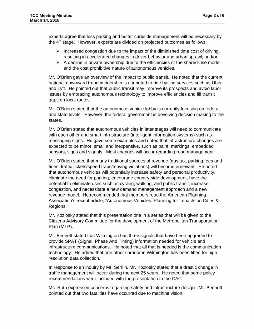
experts agree that less parking and better curbside management will be necessary by the 4th stage. However, experts are divided on projected outcomes as follows:
Increased congestion due to the impact of the diminished time cost of driving, resulting in accelerated changes in driver behavior and urban sprawl; and/or
A decline in private ownership due to the efficiencies of the shared-use model and the cost prohibitive nature of autonomous vehicles.
Mr. O’Brien gave an overview of the impact to public transit. He noted that the current national downward trend in ridership is attributed to ride hailing services such as Uber and Lyft. He pointed out that public transit may improve its prospects and avoid labor issues by embracing autonomous technology to improve efficiencies and fill transit gaps on local routes.
Mr. O’Brien stated that the autonomous vehicle lobby is currently focusing on federal and state levels. However, the federal government is devolving decision making to the states.
Mr. O’Brien stated that autonomous vehicles in later stages will need to communicate with each other and smart infrastructure (intelligent information systems) such as messaging signs. He gave some examples and noted that infrastructure changes are expected to be minor, small and inexpensive, such as paint, markings, embedded sensors, signs and signals. Most changes will occur regarding road management.
Mr. O’Brien stated that many traditional sources of revenue (gas tax, parking fees and fines, traffic tickets/speed traps/moving violations) will become irrelevant. He noted that autonomous vehicles will potentially increase safety and personal productivity, eliminate the need for parking, encourage country-side development, have the potential to eliminate uses such as cycling, walking, and public transit, increase congestion, and necessitate a new demand management approach and a new revenue model. He recommended that members read the American Planning Association’s recent article, “Autonomous Vehicles: Planning for Impacts on Cities & Regions.”
Mr. Kozlosky stated that this presentation one in a series that will be given to the Citizens Advisory Committee for the development of the Metropolitan Transportation Plan (MTP).
Mr. Bennett stated that Wilmington has three signals that have been upgraded to provide SPAT (Signal, Phase And Timing) information needed for vehicle and infrastructure communications. He noted that all that is needed is the communication technology. He added that one other corridor in Wilmington has been fitted for high resolution data collection.
In response to an inquiry by Mr. Serkin, Mr. Kozlosky stated that a drastic change in traffic management will occur during the next 25 years. He noted that some policy recommendations were included with the presentation to the CAC.
Ms. Roth expressed concerns regarding safety and infrastructure design. Mr. Bennett pointed out that two fatalities have occurred due to machine vision.

TCC Meeting Minutes Page 3 of 6 March 14, 2018
4. Consent Agenda a. Approval of TCC Meeting Minutes – February 14, 2018 b. Resolution approving 2018-2027 STIP/MTIP Modification #18-2 c. Resolution approving 2018-2027 STIP/MTIP Amendment #18-1 d. Resolution supporting an effort to explore the possible sequencing of the
construction of the Cape Fear Crossing and replacement of the Cape Fear Memorial Bridge
e. Resolution adopting the 2018 Legislative Agenda
Ms. Bunch made a motion to approve the Consent Agenda and to forward Items 4a through 4e to the Board for consideration. Ms. Kimes seconded the motion, and it carried unanimously.
5. Regular Agenda a. Resolution approving the Wilmington Urban Area MPO’s FY 19 Unified Planning
Work Program Mr. Kozlosky reminded members that a draft was presented to the committee in January. Since that time, the STP-DA budget has been increased by $20,000 to implement recommendations from the compensation analysis. He noted that the Board has directed staff to take this through the City’s budgeting process.
Ms. Barefoot made a motion to approve the Resolution approving the Wilmington Urban Area MPO’s FY’19 Unified Planning Work Program. Ms. Roth seconded the motion, and it carried unanimously.
b. Resolution Certifying the Transportation Planning Process for the Wilmington Urban Area MPO Mr. Kozlosky reminded members that the MPO is required to certify annually its transportation planning process in a continuing, cooperative and comprehensive manner in compliance with federal regulations. He noted that this resolution acknowledges and certifies compliance.
Ms. Bunch made a motion to approve the Resolution Certifying the Transportation Planning Process for the Wilmington Urban Area MPO. Ms. Kimes seconded the motion, and it carried unanimously.
c. Resolution supporting the allocation of Direct Attributable funds to the Town of Carolina Beach for the Cape Fear Multi-use Path Ms. Kimes stated that the Town of Carolina Beach bid its second STP-DA project recently and it came in slightly over budget. She noted that this resolution will cover the additional needs.
In response to an inquiry by Mr. Serkin, Ms. Kimes stated that contingency is included in all project bids. She noted that the quantities are never exact. She added that sometimes streetscape improvements are included.
Mr. Kozlosky stated that the Board has approved the use of FY’18 funds to cover cost overruns.
TCC Meeting Minutes Page 4 of 6 March 14, 2018
Following further discussion, Ms. Matheny made a motion to approve the Resolution supporting the allocation of Direct Attributable funds to the Town of Carolina Beach for the Cape Fear Multi-use Path. Mr. Serkin seconded the motion, and it carried unanimously.
d. Resolution supporting the allocation of FY18 Direct Attributable funds to the Cape Fear Public Transportation Authority Ms. Kimes stated that all of the projects for FY18 funds that were estimated or awarded were reviewed with current estimates. Wave Transit has requested the same allocation as last year. She added that the $591,000 would be used for ADA improvements such as bus stop enhancements.
In response to an inquiry by Mr. Serkin, Ms. Kimes estimated that about $400,000 would remain as surplus, assuming that all projects go to bid this year.
Mr. Kozlosky pointed out that the modal targets of 20 percent equates to $591,000. He reminded members that the MPO Board approved the use of surplus funds for overages and for Wave Transit. Although this is the process for this year, the allocation of resources for FY19 still needs to be determined.
Ms. Matheny stated that the STP-DA Subcommittee met to discuss the process for FY19.
Ms. Ayers made a motion to approve the Resolution supporting the allocation of FY18 Direct Attributable funds to the Cape Fear Public Transportation Authority. Mr. Bennett seconded the motion, and it carried unanimously.
6. Discussion a. Socio-economic Data Projections
Ms. Sarder gave an update on the socio-economic data projections. She acknowledged the presence of members of the socio-economic data committee who have been collecting parcel data for new housing units since. She noted that the last one was received on Monday and will be reviewed and incorporated into the model. She added that employment information was verified as well. She stated that the base year model should be complete by the end of this month and the future model, by June.
In response to an inquiry by Mr. Kozlosky, Ms. Sarder stated that the committee will be reconvened for future year data verification.
In response to an inquiry by Mr. Serkin, Ms. Sarder stated that a presentation would be given to the TCC and the Board in April.
In response to an inquiry by Mr. Bennett regarding an interactive model that could be updated on the fly, Ms. Sarder stated that the current model is merely an update. She noted that the next model would be developed from scratch. She acknowledged that the committee worked diligently to update the model that includes more than 600 TAZs.

TCC Meeting Minutes Page 5 of 6 March 14, 2018
7. Updates a. MPO Staffing
Mr. Kozlosky introduced the newest staff member, Fred Royal, Project Engineer, who started on March 5th.
Mr. Royal expressed appreciation and gave some background information.
Mr. Kozlosky noted that other updates are included in the agenda packet.
8. Announcements NCDOT’s Public Transportation Statewide Strategic Plan Summit: March 21st
Ms. Matheny offered members the option of carpooling to Raleigh.
Next WMPO Bike/Ped Committee meeting: April 10th Mr. Kozlosky stated that appointments are still needed from the City of Wilmington, the Cape Fear Public Transportation Authority and the Town of Kure Beach. He noted that the River to the Sea Bike Ride event has been scheduled for May 5th.
NCPTA Conference: April 23rd-25th Ms. Matheny stated that the conference would be held at the Wilmington Convention Center. She noted that the keynote speaker will discuss autonomous vehicles and encouraged anyone with an interest to attend.
Mr. Kozlosky stated that the next TCC meeting will be on April 11th at the usual time at this location (the Harnett Room of the Main Branch of the New Hanover County Public Library).
In response to an inquiry by Ms. Matheny, Mr. Kozlosky stated that the Citizens Advisory Committee (CAC) is structured the same as in the past. He noted that the kickoff event is scheduled for April 3rd at the Northeast Branch of the New Hanover County Public Library. He added that two speakers have been secured, Board Vice Chair Pat Batleman and CAC Chair Laura Padgett. He noted that the speakers will be sandwiched between two open houses.
Mr. Kozlosky stated that presentations to the boards and member jurisdictions are scheduled for April; five open houses at various locations in May; and public comment will be collected through July 31st. Then, stakeholders in modal subcommittees will meet and develop project lists. Also, the consultant, WSP, has been contracted to help with public outreach and the financial analysis; although most of the effort will be in-house.
Ms. Matheny requested a “save-the-date” for the April 3rd kick-off event to share with members’ distribution networks. Ms. Lorenzo stated that one was sent to Ms. Lacer and that it has also been shared on social media.
Ms. Bunch expressed concerns regarding social media and requested that traditional media be used. Mr. Kozlosky responded that a press release is being prepared; and will be distributed.

TCC Meeting Minutes Page 6 of 6 March 14, 2018
9. Adjournment With no further items, the meeting was adjourned at 11:06 a.m.
THE ABOVE MINUTES ARE NOT A VERBATIM RECORD OF THE PROCEEDINGS. THE ENTIRE PROCEEDINGS ARE RECORDED ON A COMPACT DISC
AS PART OF THIS RECORD.

WILMINGTON URBAN AREA METROPOLITAN PLANNING ORGANIZATION BOARD
RESOLUTION APPROVING AN ADMINISTRATIVE MODIFICATION #18-3 TO THE
2018-2027 STATE/MPO TRANSPORTATION IMPROVEMENT PROGRAMS FOR PERFORMANCE MANAGEMENT
WHEREAS, the Wilmington Urban Area Metropolitan Planning Organization provides transportation planning services for the City of Wilmington, Town of Carolina Beach, Town of Kure Beach, Town of Wrightsville Beach, Town of Belville, Town of Leland, Town of Navassa, New Hanover County, Brunswick County, Pender County, Cape Fear Public Transportation Authority and the North Carolina Board of Transportation; and WHEREAS, the Board has found that the Wilmington Urban Area Metropolitan Planning Organization is conducting transportation planning in a continuous, cooperative, and comprehensive manner; and WHEREAS, the North Carolina Board of Transportation adopted the 2018-2027 State Transportation Improvement Program on August 3, 2017 and the Wilmington Urban Area Metropolitan Planning Organization Board adopted the Statewide/Metropolitan Transportation Improvement Programs on August 30, 2017; and WHEREAS, the Wilmington Urban Area Metropolitan Planning Organization desires to modify the adopted 2018-2027 Transportation Improvement Program to ensure compliance with federal law; and WHEREAS, 23 CFR 450.326 (d) states that “the TIP shall include, to the maximum extent practicable, a description of the anticipated effect of the TIP toward achieving the performance targets identified in the metropolitan transportation plan, linking investment priorities to those performance targets”; and WHEREAS, the amended language needs to be in the MPO’s Transportation Improvement Program by May 27, 2018 or FHWA will not recognize any future TIP modifications for the MPO after that date; and NOW THEREFORE, be it resolved that the Board of the Wilmington Urban Area Metropolitan Planning Organization hereby approves modifying the 2018-2027 State/MPO Transportation Improvement Programs to include the following language: The Wilmington Urban Area Metropolitan Planning Organization has established performance management targets for highway safety and for transit tier 2 providers that chose to participate in NCDOT’s Group Transit Asset Management (TAM) Plan and will establish federally mandated performance management targets for infrastructure condition, congestion, system reliability, emissions and freight movement. The Wilmington Urban Area Metropolitan Planning Organization anticipates meeting their identified targets with the mix of projects included in the TIP.

ADOPTED at a regular meeting of the Wilmington Urban Area Metropolitan Planning Organization’s Board on April 18, 2018. David Piepmeyer, Chair Mike Kozlosky, Secretary


WILMINGTON URBAN AREA METROPOLITAN PLANNING ORGANIZATION BOARD
RESOLUTION SUPPORTING THE ALLOCATION OF ADDITIONAL SURFACE TRANSPORTATION BLOCK GRANT PROGRAM- DIRECT ATTRIBUTABLE FUNDS TO THE CITY OF WILMINGTON FOR THE SHIPYARD BOULEVARD BUS PULLOUT AND
SIDEWALK PROJECT WHEREAS, the Wilmington Urban Area Metropolitan Planning Organization provides transportation planning services for the City of Wilmington, Town of Carolina Beach, Town of Kure Beach, Town of Wrightsville Beach, Town of Belville, Town of Leland, Town of Navassa, New Hanover County, Brunswick County, Pender County, Cape Fear Public Transportation Authority and the North Carolina Board of Transportation; and WHEREAS, on July 18, 2012 the Federal Transit Administration (FTA) and the Federal Highways Administration (FHWA) designated the Wilmington Urban Area Metropolitan Planning Organization as a Transportation Management Area (TMA); and WHEREAS, Surface Transportation Block Grant Program- Direct Attributable (STBGP-DA) funds are available for all designated TMAs; and WHEREAS, the STBGP-DA program was previously known as the Surface Transportation Program-Direct Attributable (STP-DA) program under Moving Ahead for Progress in the 21st Century Act (MAP-21); and WHEREAS, the Wilmington Urban Area Metropolitan Planning Organization’s Board allocated FY 14 STP-DA funds to the Shipyard Bus Pullout and Sidewalk project for the construction of a bus pullout along Shipyard Boulevard and sidewalk that will begin at Rutledge Drive and terminate at Vance Street; and WHEREAS, the City of Wilmington has requested an additional $80,000 from the Wilmington Urban Area Metropolitan Planning Organization for un-anticipated project costs; and WHEREAS, by Resolution the City of Wilmington has approved the required 20% local match. NOW THEREFORE, be it resolved that the Board of the Wilmington Urban Area Metropolitan Planning Organization hereby supports the allocation of additional STBGP-DA funds to the City of Wilmington Shipyard Boulevard Bus Pullout and Sidewalk project. ADOPTED at a regular meeting of the Wilmington Urban Area Metropolitan Planning Organization’s Board on April 18, 2018. _________________________________ David Piepmeyer, Chair _________________________________ Mike Kozlosky, Secretary

DR
AFT
Prio
ritiz
atio
n 5.
0 Pr
ogra
mm
ed S
tate
wid
e M
obili
ty P
roje
cts
Pro
ject
s S
orte
d by
Div
isio
n (a
scen
ding
), th
en S
core
(des
cend
ing)
Apr
il 2,
201
8
SPO
T ID
Mod
eTI
PPr
ojec
t C
ateg
ory
Rou
te /
Faci
lity
Nam
eFr
om /
Cro
ss S
tree
t (Pr
ojec
t Ti
tle fo
r Avi
atio
n)To
Des
crip
tion
Spec
ific
Impr
ovem
ent T
ype
Leng
th
(Mile
s)D
ivis
ion(
s)C
ount
y(s)
Stat
ewid
e M
obili
ty
Qua
ntita
tive
Scor
e(O
ut o
f 100
)
Cos
t to
NC
DO
TPr
ogra
mm
ed
Am
ount
(202
0-20
29)
Draft Right‐of‐
Way Date
Draft
Constructio
n Date
Fund
ed Status
H09
0230
Hig
hway
R-3
419
Sta
tew
ide
Mob
ility
US
158
(Cro
atan
H
ighw
ay)
US
64-
NC
12
Eas
tern
End
of W
right
B
roth
ers
Mem
oria
l Brid
geA
cces
s M
anag
emen
t Im
prov
emen
ts11
- A
cces
s M
anag
emen
t16
.11
01D
are
79.5
6 $
9
7,80
0,00
0 $
97,
800,
000
FY 2
025
FY 2
027
Sta
tew
ide
Mob
ility
R17
1422
Rai
lP
-574
1S
tate
wid
e M
obili
tyC
SX
A L
ine
Con
stru
ct n
ew m
ain
track
bet
wee
n M
P
A-8
0.7
and
MP
A-8
2.4
incl
udin
g re
habi
litat
ion/
reco
nstru
ctio
n of
CS
X S
A-
line
brid
ge o
ver t
he R
oano
ke R
iver
and
co
nstru
ctio
n of
a n
ew c
onne
ctio
n be
twee
n C
SX
A-li
ne a
nd C
SX
SA
-line
at
MP
A-8
0.7,
reco
nstru
ctio
n of
exi
stin
g si
ding
as
mai
n tra
ck b
etw
een
MP
A-
82.4
and
MP
A-8
4.7,
and
railr
oad
sign
al
cons
truct
ion
to e
ffect
ivel
y cr
eate
a
seco
nd m
ain
track
alo
n g th
e C
SX
A-li
ne
betw
een
the
new
con
nect
ion
at A
-80.
7 an
d th
e ex
istin
g W
eldo
n ra
ilroa
d co
ntro
l po
int a
t A-8
4.7.
Add
ition
ally, the
project include
s closure of C
arolina
Aven
ue existing at‐grade
crossing
(Crossing # 62
9 65
2L).
Frei
ght r
ail
infra
stru
ctur
e im
prov
emen
t or
cons
truct
ion
11.0
001
, 04
Nor
tham
pton
, Hal
ifax
82.2
0 $
6
7,00
0,00
0 $
67,
000,
000
FY 2
025
FY 2
027
Sta
tew
ide
Mob
ility
R17
1669
Rai
lP
-574
2S
tate
wid
e M
obili
tyN
S/N
CR
R E
C L
ine
Con
stru
ctio
n of
gra
de s
epar
atio
ns a
t U
S 7
0 E
astb
ound
(Cro
ssin
g #
722
672A
) and
US
70
Wes
tbou
nd (C
ross
ing
# 94
9 74
7C)
and
clos
ure
of e
xist
ing
at-
grad
e cr
ossi
ngs
near
New
port.
Hig
hway
-rai
l cr
ossi
ng
impr
ovem
ent
0.00
02C
rave
n77
.02
$
14,
350,
000
$
1
0,23
4,00
0 FY
202
6FY
202
8S
tate
wid
e M
obili
ty
H17
0112
Hig
hway
U-6
102
Sta
tew
ide
Mob
ility
US
70
SR
130
9 (G
lenb
urni
e R
oad)
Impr
ove
Inte
rcha
nge
8 - I
mpr
ove
Inte
rcha
nge
2.00
02C
rave
n75
.74
$
10,
800,
000
$
6,50
0,00
0 FY
202
7FY
202
9S
tate
wid
e M
obili
ty
H09
0795
-AH
ighw
ayR
-577
7CS
tate
wid
e M
obili
tyU
S 7
0Th
urm
an R
oad
Hav
eloc
k B
ypas
sU
pgra
de R
oadw
ay to
Fre
eway
and
C
onst
ruct
Ser
vice
Roa
ds
2 - U
pgra
de A
rteria
l to
Fr
eew
ay/E
xpre
ssw
ay
6.88
02C
rave
n75
.25
$ 1
31,9
00,0
00
$
131
,900
,000
FY
202
0FY
202
0S
tate
wid
e M
obili
ty
R17
0187
Rai
lP
-574
0S
tate
wid
e M
obili
tyC
SX
SE
Lin
e
The
impr
oved
saf
ety
to th
e tra
in
oper
atio
n is
cou
pled
with
the
incr
ease
in
trai
n sp
eed
from
10
mph
to a
25
mph
m
axim
um.
To in
crea
se th
e sp
eed
betw
een
Dav
is Y
ard
and
3rd
Stre
et a
pr
ogra
m o
f tie
and
rail
reha
bilit
atio
n w
ill
be u
nder
take
n to
brin
g th
e lin
e of
ra
ilroa
d fro
m C
lass
1 to
Cla
ss 2
Fed
eral
R
ailro
ad A
utho
rity
track
saf
ety
desi
gnat
ion.
Alo
ng w
ith th
e ra
il an
d tie
in
stal
latio
n w
ill c
ome
impr
ovem
ents
to
the
high
way
gra
de c
ross
ing
surfa
ces,
cu
rve
re-a
lignm
ents
and
upg
rade
d sw
itch
oper
atio
ns. The
project
prop
oses to
close th
ree existing at‐
grade crossin
gs (M
artin
Street n
ear
Hoop
er Street, Martin
Street p
ortio
n ne
ar 6th Street, and Clay Street) and
im
prove 23
existing at‐grade
crossings.
Frei
ght r
ail
infra
stru
ctur
e im
prov
emen
t or
cons
truct
ion
13.0
003
New
Han
over
89.3
3 $
4
1,40
0,00
0 $
41,
400,
000
FY 2
025
FY 2
027
Sta
tew
ide
Mob
ility
A17
0920
Avi
atio
nA
V-5
884
Sta
tew
ide
Mob
ility
ILM
- W
ilmin
gton
In
tern
atio
nal A
irpor
tIL
M -
Taxi
way
B E
xten
sion
at
Run
way
24
App
roac
h
Des
ign
and
cons
truct
an
exte
nsio
n of
ta
xiw
a y B
at t
he a
ppro
ach
of ru
nway
24.
Incl
udes
Pro
ject
Req
uest
Num
ber:
00
0038
22
0535
- R
unw
ay
Leng
th: T
axiw
ay
Ext
ensi
on03
New
Han
over
88.8
2 $
50
0,00
0 $
500,
000
FY 2
027
Sta
tew
ide
Mob
ility
A17
0916
Avi
atio
nA
V-5
885
Sta
tew
ide
Mob
ility
ILM
- W
ilmin
gton
In
tern
atio
nal A
irpor
tIL
M -
Run
way
6-2
4 P
avem
ent
Reh
abili
tatio
n
Reh
abili
tate
runw
ay 6
-24
due
to it
ex
ceed
ing
its u
sefu
l life
of 2
0 ye
ars.
S
igns
of a
lliga
tor c
rack
ing
in th
e pa
vem
ent a
nd e
xpos
ed a
ggre
gate
on
the
runw
ay. T
his
proj
ect w
ill in
clud
e al
l ru
nway
mar
king
s an
d po
ssib
le ta
xiw
ay
mar
king
s. In
clud
es P
roje
ct R
eque
st
Num
ber:
000
0378
7
0605
- P
avem
ent
Stre
ngth
- R
unw
ay03
New
Han
over
87.4
8 $
50
0,00
0 $
500,
000
FY 2
027
Sta
tew
ide
Mob
ility
Dat
a su
bjec
t to
chan
ge b
ased
on
cont
inue
d ev
alua
tion
Dat
a an
d co
sts
are
for p
riorit
izat
ion
purp
oses
onl
yD
RA
FT:
SUB
JEC
T TO
CH
AN
GE
1

DR
AFT
Prio
ritiz
atio
n 5.
0 Pr
ogra
mm
ed S
tate
wid
e M
obili
ty P
roje
cts
Pro
ject
s S
orte
d by
Div
isio
n (a
scen
ding
), th
en S
core
(des
cend
ing)
Apr
il 2,
201
8
SPO
T ID
Mod
eTI
PPr
ojec
t C
ateg
ory
Rou
te /
Faci
lity
Nam
eFr
om /
Cro
ss S
tree
t (Pr
ojec
t Ti
tle fo
r Avi
atio
n)To
Des
crip
tion
Spec
ific
Impr
ovem
ent T
ype
Leng
th
(Mile
s)D
ivis
ion(
s)C
ount
y(s)
Stat
ewid
e M
obili
ty
Qua
ntita
tive
Scor
e(O
ut o
f 100
)
Cos
t to
NC
DO
TPr
ogra
mm
ed
Am
ount
(202
0-20
29)
Draft Right‐of‐
Way Date
Draft
Constructio
n Date
Fund
ed Status
A15
0418
Avi
atio
nA
V-5
798
Sta
tew
ide
Mob
ility
ILM
- W
ilmin
gton
In
tern
atio
nal A
irpor
tIL
M -
Term
inal
Apr
on H
ot-
Spo
t Im
prov
emen
ts
Rem
edia
te P
oten
tial "
Hot
Spo
ts" a
t Te
rmin
al A
pron
(Rel
ocat
e Ta
xiw
ay B
at
Air
Car
rier A
pron
, Rem
ove
Taxi
way
F,
Rem
ove
Por
tion
of T
axiw
ay J
)In
clud
es P
roje
ct R
eque
st N
umbe
r:
0000
3434
1100
- Ta
xiw
ay
Req
uire
men
ts03
New
Han
over
86.5
5 $
50
0,00
0 $
500,
000
FY 2
026
Sta
tew
ide
Mob
ility
A17
0936
Avi
atio
nA
V-5
886
Sta
tew
ide
Mob
ility
ILM
- W
ilmin
gton
In
tern
atio
nal A
irpor
tIL
M -
Taxi
way
J
Impr
ovem
ents
This
pro
ject
will
be
desi
gned
and
co
nstru
cted
to m
eet t
he n
ew F
AA
re
quire
men
ts w
hich
doe
s no
t allo
w
dire
ct a
cces
s to
or f
rom
an
airc
raft
ram
p to
a ru
nway
. Inc
lude
s P
roje
ct
Req
uest
Num
ber:
000
0381
0
1100
- Ta
xiw
ay
Req
uire
men
ts03
New
Han
over
83.2
0 $
50
0,00
0 $
500,
000
FY 2
027
Sta
tew
ide
Mob
ility
A17
0913
Avi
atio
nA
V-5
887
Sta
tew
ide
Mob
ility
ILM
- W
ilmin
gton
In
tern
atio
nal A
irpor
tIL
M -
Mid
field
Tax
iway
Im
prov
emen
ts
This
pro
ject
is F
AA
Hot
Spo
t, w
hich
is
cons
ider
ed a
saf
ety
issu
e. T
his
is a
n ar
ea lo
cate
d on
the
airp
ort w
here
a p
ilot
may
get
con
fuse
d du
e to
one
loca
tion
with
five
pos
sibl
e ch
oice
s of
dire
ctio
n of
tra
vel n
ear i
nter
sect
ing
runw
ays.
In
clud
es P
roje
ct R
eque
st N
umbe
r:
0000
3760
1100
- Ta
xiw
ay
Req
uire
men
ts03
New
Han
over
82.1
2 $
50
0,00
0 $
500,
000
FY 2
027
Sta
tew
ide
Mob
ility
A15
0114
Avi
atio
nA
V-5
799
Sta
tew
ide
Mob
ility
ILM
- W
ilmin
gton
In
tern
atio
nal A
irpor
tIL
M -
Wid
en N
orth
-Sou
th
Taxi
way
Sys
tem
The
airp
ort h
as h
ad p
lans
to w
iden
the
Nor
th-S
outh
TW
Y s
yste
m to
mak
e th
e w
idth
con
sist
ent t
hrou
ghou
t. C
urre
ntly
th
e TW
Y s
yste
m w
idth
rang
es fr
om 5
1 to
75
feet
. The
pro
ject
will
als
o ad
d sh
ould
ers
and
keep
the
TWY
ligh
ts o
n pa
vem
ent t
o re
duce
mow
ing
and
mai
nten
ance
. Inc
lude
s P
roje
ct R
eque
st
Num
ber:
0000
2988
1100
- Ta
xiw
ay
Req
uire
men
ts03
New
Han
over
81.5
5 $
50
0,00
0 $
500,
000
FY 2
027
Sta
tew
ide
Mob
ility
H17
0604
Hig
hway
U-4
007F
Sta
tew
ide
Mob
ility
US
17
(Mar
ine
Blv
d)M
cDan
iel D
r
Add
left
turn
lane
on
McD
anie
l Dr.;
add
rig
ht tu
rn la
ne o
n W
orks
hop
Ln; a
dd
cros
s-w
alks
, cur
b ra
mps
, ped
sig
nals
, im
prov
e dr
aina
ge s
truct
ure
unde
r M
cDan
iel D
r.
10 -
Impr
ove
Inte
rsec
tion
0.50
03O
nslo
w81
.31
$
1,
400,
000
$
1,40
0,00
0 FY
202
5FY
202
7S
tate
wid
e M
obili
ty
A15
0423
Avi
atio
nA
V-5
796
Sta
tew
ide
Mob
ility
ILM
- W
ilmin
gton
In
tern
atio
nal A
irpor
tIL
M -
Wid
en T
axiw
ays
Incr
ease
wid
th o
f all
taxi
way
s to
75'
that
w
ill a
ccom
enda
te a
ll ai
rcra
ft th
at u
tiliz
e IL
M.
Incl
udes
Pro
ject
Req
uest
Num
ber:
00
0034
50
1100
- Ta
xiw
ay
Req
uire
men
ts03
New
Han
over
80.1
6 $
50
0,00
0 $
500,
000
FY 2
026
Sta
tew
ide
Mob
ility
A15
0113
Avi
atio
nA
V-5
797
Sta
tew
ide
Mob
ility
ILM
- W
ilmin
gton
In
tern
atio
nal A
irpor
t
ILM
- N
ew C
oncr
ete
Apr
on,
Exi
ting
Apr
on O
verla
y, a
nd
Taxi
way
A T
ie-in
s
Pro
ject
incl
udes
ove
rlay
of e
xist
ing
WW
II-er
a co
ncre
te p
avem
ent w
ith n
ew
conc
rete
pav
emen
t; co
nstru
ctio
n of
new
co
ncre
te a
pron
and
bitu
min
ous
tie-in
s to
Tax
iway
A; a
nd c
onst
ruct
ion
of s
torm
dr
ain
infra
stru
ctur
e (R
CP
to c
onve
y st
orm
dra
inag
e fro
m N
orth
GA
R
edev
elop
men
t Are
a to
the
exis
ting
Ext
ende
d D
ry D
eten
tion
Bas
in).
The
proj
ect i
s in
acc
orda
nce
with
the
Airp
ort's
GA
Mas
ter P
lan
as w
ell a
s th
e S
torm
wat
er M
aste
r Pla
n P
erm
it.
Incl
udes
Pro
ject
Req
uest
Num
ber:
0000
3413
1200
- A
ircra
ft A
pron
/ H
elip
ad
Req
uire
men
ts03
New
Han
over
77.2
7 $
50
0,00
0 $
500,
000
FY 2
026
Sta
tew
ide
Mob
ility
A15
0118
Avi
atio
nA
V-5
801
Sta
tew
ide
Mob
ility
ILM
- W
ilmin
gton
In
tern
atio
nal A
irpor
tIL
M -
Air
Car
rier A
pron
E
xpan
sion
Con
stru
ctio
n fo
r exp
ansi
on o
f the
Air
Car
rier A
pron
in s
uppo
rt of
the
prop
osed
term
inal
exp
ansi
on p
roje
ct.
Incl
udes
Pro
ject
Req
uest
Num
ber:
1200
- A
ircra
ft A
pron
/ H
elip
ad
Req
uire
men
ts03
New
Han
over
76.9
6 $
50
0,00
0 $
500,
000
FY 2
027
Sta
tew
ide
Mob
ility
A15
0101
Avi
atio
nA
V-5
795
Sta
tew
ide
Mob
ility
ILM
- W
ilmin
gton
In
tern
atio
nal A
irpor
tIL
M -
GA
Apr
on E
xpan
sion
Exp
and
the
GA
Apr
on g
rass
ed a
rea
to
pave
d su
rface
to a
ccom
mod
ate
addi
tiona
l tie
dow
n sp
ace
for a
ircra
ft.
Incl
udes
Pro
ject
Req
uest
Num
ber:
0000
3432
.
1200
- A
ircra
ft A
pron
/ H
elip
ad
Req
uire
men
ts03
New
Han
over
74.7
9 $
50
0,00
0 $
500,
000
FY 2
026
Sta
tew
ide
Mob
ility
H11
1256
-BH
ighw
ayR
-582
9BS
tate
wid
e M
obili
tyU
S 7
0W
est o
f SR
122
9 (L
uby
Sm
ith
Roa
d)E
ast o
f SR
231
4 (P
ondf
ield
R
oad)
Impr
ove
Exi
stin
g U
S 7
0 to
Fre
eway
S
tand
ards
from
Lub
y S
mith
Roa
d to
P
ondf
ield
Roa
d
2 - U
pgra
de A
rteria
l to
Fr
eew
ay/E
xpre
ssw
ay
3.44
04Jo
hnst
on, W
ayne
77.6
4 $
6
2,00
0,00
0 $
62,
000,
000
FY 2
025
FY 2
027
Sta
tew
ide
Mob
ility
Dat
a su
bjec
t to
chan
ge b
ased
on
cont
inue
d ev
alua
tion
Dat
a an
d co
sts
are
for p
riorit
izat
ion
purp
oses
onl
yD
RA
FT:
SUB
JEC
T TO
CH
AN
GE
2

DR
AFT
Prio
ritiz
atio
n 5.
0 Pr
ogra
mm
ed S
tate
wid
e M
obili
ty P
roje
cts
Pro
ject
s S
orte
d by
Div
isio
n (a
scen
ding
), th
en S
core
(des
cend
ing)
Apr
il 2,
201
8
SPO
T ID
Mod
eTI
PPr
ojec
t C
ateg
ory
Rou
te /
Faci
lity
Nam
eFr
om /
Cro
ss S
tree
t (Pr
ojec
t Ti
tle fo
r Avi
atio
n)To
Des
crip
tion
Spec
ific
Impr
ovem
ent T
ype
Leng
th
(Mile
s)D
ivis
ion(
s)C
ount
y(s)
Stat
ewid
e M
obili
ty
Qua
ntita
tive
Scor
e(O
ut o
f 100
)
Cos
t to
NC
DO
TPr
ogra
mm
ed
Am
ount
(202
0-20
29)
Draft Right‐of‐
Way Date
Draft
Constructio
n Date
Fund
ed Status
H11
1256
-AH
ighw
ayR
-582
9AS
tate
wid
e M
obili
tyU
S 7
0U
S 7
0 B
ypas
s (W
est
Term
inus
, Eas
t of S
R 1
408)
Wes
t of S
R 1
229
(Lub
y S
mith
Roa
d)
Impr
ove
Exi
stin
g U
S 7
0 to
Fre
eway
S
tand
ards
from
the
Wes
t End
of t
he U
S
70 B
ypas
s to
the
Way
ne/J
ohns
ton
Cou
nty
Line
2 - U
pgra
de A
rteria
l to
Fr
eew
ay/E
xpre
ssw
ay
3.45
04W
ayne
75.2
4 $
6
2,90
0,00
0 $
62,
900,
000
FY 2
023
FY 2
023
Sta
tew
ide
Mob
ility
H17
1573
Hig
hway
I-600
5S
tate
wid
e M
obili
tyI-8
7, U
S 6
4U
S 6
4 B
usin
ess
(Wen
dell
Blv
d)U
S 2
64W
iden
I-87
from
four
to s
ix la
nes
from
W
ende
ll B
lvd
to th
e U
S 6
4 / U
S 2
64
split
1 - W
iden
Exi
stin
g R
oadw
ay6.
8305
Wak
e84
.87
$
59,
100,
000
$
5
9,10
0,00
0 FY
202
5FY
202
6S
tate
wid
e M
obili
ty
H17
2171
Hig
hway
I-600
6S
tate
wid
e M
obili
tyI-4
0N
C 5
4 (E
xit 2
73)
SR
172
8 (W
ade
Ave
)C
onve
rt fa
cilit
y to
a m
anag
ed fr
eew
ay
("m
anag
ed m
otor
way
") w
ith ra
mp
met
erin
g an
d ot
her A
TM/IT
S.
12 -
Ram
p M
eter
ing
15.7
605
Dur
ham
, Wak
e83
.91
$
54,
530,
800
$
5
4,55
0,00
0 FY
202
5FY
202
5S
tate
wid
e M
obili
ty
H14
9000
-FH
ighw
ayU
-577
4FS
tate
wid
e M
obili
tyI-4
0N
C 5
4 / F
arrin
gton
Roa
d /
Falc
onbr
idge
Roa
d
Impr
ove
Inte
rcha
n ge
at I-
40 a
nd N
C 5
4,
cons
truct
gra
de s
epar
atio
n an
d sl
ip
ram
p at
Far
ringt
on R
oad,
con
stru
ct
inte
rcha
nge
at F
alco
nbrid
ge R
oad,
and
pr
ovid
e a
conn
ecto
r bet
wee
n Fa
rrin
gton
an
d Fa
lcon
brid
ge R
oads
8 - I
mpr
ove
Inte
rcha
nge
2.00
05D
urha
m83
.43
$
94,
100,
000
$
7
9,00
0,00
0 FY
202
5FY
202
8S
tate
wid
e M
obili
ty
H17
1559
Hig
hway
I-600
7S
tate
wid
e M
obili
tyI-8
7, U
S 6
4S
R 2
233
(Sm
ithfie
ld R
oad)
Con
vert
inte
rcha
nge
to D
DI
8 - I
mpr
ove
Inte
rcha
nge
2.00
05W
ake
83.4
2 $
7,40
0,00
0 $
7,
400,
000
FY 2
025
FY 2
026
Sta
tew
ide
Mob
ility
R15
0272
Rai
lP
-573
4S
tate
wid
e M
obili
tyN
S/N
CR
R H
Lin
e
CS
X/N
CR
R S
Lin
e
Con
stru
ctio
n of
2 la
ne g
rade
sep
arat
ion
at S
R 1
655
(Trin
ity R
oad)
and
clo
sure
of
exi
stin
g at
-gra
de c
ross
ing
(Cro
ssin
g #
630
657S
) in
Car
y. P
roje
ct in
clud
es
purc
hase
of R
OW
for f
ull 4
-lane
div
ided
se
ctio
n.
Hig
hway
-rai
l cr
ossi
ng
impr
ovem
ent
0.00
05W
ake
83.0
7 $
3
6,86
5,00
0 $
36,
865,
000
FY 2
025
FY 2
028
Sta
tew
ide
Mob
ility
H17
1350
Hig
hway
I-601
0S
tate
wid
e M
obili
tyI-8
5E
ast o
f Mid
land
Ter
race
at
lane
add
/dro
pR
ed M
ill R
oad
Wid
en ro
adw
ay a
nd im
prov
e ra
mps
(le
ngth
en o
n ra
mps
and
rem
ove
two-
way
ram
ps).
1 - W
iden
Exi
stin
g R
oadw
ay3.
1905
Dur
ham
79.5
8 $
102
,800
,000
$
32,
000,
000
FY 2
027
FY 2
029
Sta
tew
ide
Mob
ility
R15
0275
Rai
lP
-573
6S
tate
wid
e M
obili
tyN
S/N
CR
R H
Lin
e
CS
X/N
CR
R S
Lin
e
Con
stru
ct B
eryl
Roa
d ex
tens
ion
to
Roy
al A
venu
e an
d cl
osur
e of
exi
sitn
g B
eryl
Roa
d at
-gra
de c
ross
ing
(Cro
ssin
g #
630
647L
) in
Ral
eigh
.
Hig
hway
-rai
l cr
ossi
ng
impr
ovem
ent
0.00
05W
ake
78.0
7 $
3,19
6,00
0 $
3,
196,
000
FY 2
026
FY 2
027
Sta
tew
ide
Mob
ility
R14
1797
Rai
lP
-570
6S
tate
wid
e M
obili
tyN
S/N
CR
R H
Lin
e
Con
stru
ct e
xten
sion
of E
ast D
urha
m
Sid
ing.
Incl
udes
a c
ombi
natio
n of
gra
de
sepa
ratio
ns a
nd c
losu
re a
t thr
ee
cros
sing
s: E
llis
Roa
d - s
outh
end
(7
3473
7A),
Glo
ver R
oad
(734
735L
), an
d W
renn
Roa
d (7
3473
6T).
Frei
ght r
ail
infra
stru
ctur
e im
prov
emen
t or
cons
truct
ion
6.90
05D
urha
m77
.80
$
42,
000,
000
$
4
2,00
0,00
0 FY
202
3FY
202
6S
tate
wid
e M
obili
ty
R15
0279
Rai
lP
-573
7S
tate
wid
e M
obili
tyC
SX
S L
ine
Con
stru
ctio
n of
gra
de s
epar
atio
n at
SR
21
08 (M
illbr
ook
Roa
d) a
nd c
losu
re o
f ex
istin
g at
-gra
de c
ross
ing
(Cro
ssin
g #
6306
05A
) in
Ral
eigh
.
Hig
hway
-rai
l cr
ossi
ng
impr
ovem
ent
0.00
05W
ake
77.7
2 $
1
3,35
0,00
0 $
13,
350,
000
FY 2
026
FY 2
028
Sta
tew
ide
Mob
ility
R17
1513
Rai
lP
-573
8S
tate
wid
e M
obili
tyN
S/N
CR
R H
Lin
e
Con
stru
ctio
n of
gra
de s
epar
atio
n at
V
ando
ra S
prin
gs R
oad
and
clos
ure
of
exis
ting
at-g
rade
cro
ssin
g (C
ross
ing
#735
324
J) in
Gar
ner.
Hig
hway
-rai
l cr
ossi
ng
impr
ovem
ent
0.00
05W
ake
77.6
4 $
1
2,72
5,00
0 $
12,
725,
000
FY 2
026
FY 2
028
Sta
tew
ide
Mob
ility
R17
1528
Rai
lP
-573
9S
tate
wid
e M
obili
tyC
SX
S L
ine
Con
stru
ctio
n of
gra
de s
epar
atio
n of
SR
14
15 (S
W M
ayna
rd R
oad)
and
clo
sure
of
exi
stin
g at
-gra
de c
ross
ing
(Cro
ssin
g #
643
400U
) in
Car
y.
Hig
hway
-rai
l cr
ossi
ng
impr
ovem
ent
0.00
05W
ake
75.9
9 $
1
5,88
0,00
0 $
15,
880,
000
FY 2
027
FY 2
029
Sta
tew
ide
Mob
ility
H11
1022
-CH
ighw
ayU
-606
6S
tate
wid
e M
obili
tyU
S 1
NC
55
US
64
Wid
en ro
adw
ay to
six
lane
s1
- Wid
en E
xist
ing
Roa
dway
3.13
05W
ake
74.6
0 $
5
8,30
0,00
0 $
58,
300,
000
FY 2
024
FY 2
026
Sta
tew
ide
Mob
ility
H12
9617
Hig
hway
R-2
829
Sta
tew
ide
Mob
ility
NC
540
(New
Rou
te -
Eas
tern
Wak
e Fr
eew
ay (T
oll))
I-40
I-87,
US
64
Con
stru
ct F
reew
ay o
n N
ew L
ocat
ion
(toll)
5 - C
onst
ruct
R
oadw
ay o
n N
ew
Loca
tion
10.6
105
, 04
Wak
e, J
ohns
ton
82.4
5 $
390
,105
,000
$
2
09,2
15,0
00
FY 2
027
FY 2
027
Sta
tew
ide
Mob
ility
H17
2036
Hig
hway
U-6
101
Sta
tew
ide
Mob
ility
I-440
, I-4
0, I-
87, U
S 1
I-540
Nor
th o
f Ral
eigh
NC
-540
Sou
th o
f Ral
eigh
Con
vert
inte
rsta
tes
and
freew
ays
to
man
aged
mot
orw
ays
incl
udin
g, I-
40
from
Wad
e A
ve to
NC
42,
I-44
0, I-
87 to
I-5
40, a
nd U
S-1
sou
th to
NC
-540
.
12 -
Ram
p M
eter
ing
53.1
905
, 04
Wak
e, J
ohns
ton
81.2
2 $
130
,273
,200
$
97,
725,
000
FY 2
026
FY 2
027
Sta
tew
ide
Mob
ility
Dat
a su
bjec
t to
chan
ge b
ased
on
cont
inue
d ev
alua
tion
Dat
a an
d co
sts
are
for p
riorit
izat
ion
purp
oses
onl
yD
RA
FT:
SUB
JEC
T TO
CH
AN
GE
3

DR
AFT
Prio
ritiz
atio
n 5.
0 Pr
ogra
mm
ed S
tate
wid
e M
obili
ty P
roje
cts
Pro
ject
s S
orte
d by
Div
isio
n (a
scen
ding
), th
en S
core
(des
cend
ing)
Apr
il 2,
201
8
SPO
T ID
Mod
eTI
PPr
ojec
t C
ateg
ory
Rou
te /
Faci
lity
Nam
eFr
om /
Cro
ss S
tree
t (Pr
ojec
t Ti
tle fo
r Avi
atio
n)To
Des
crip
tion
Spec
ific
Impr
ovem
ent T
ype
Leng
th
(Mile
s)D
ivis
ion(
s)C
ount
y(s)
Stat
ewid
e M
obili
ty
Qua
ntita
tive
Scor
e(O
ut o
f 100
)
Cos
t to
NC
DO
TPr
ogra
mm
ed
Am
ount
(202
0-20
29)
Draft Right‐of‐
Way Date
Draft
Constructio
n Date
Fund
ed Status
H09
0366
-BH
ighw
ayU
-606
7S
tate
wid
e M
obili
tyI-4
0
US
15-
501
Inte
rcha
nge
incl
udin
g M
t. M
oria
h R
oad
and
SW
Dur
ham
Driv
e In
ters
ectio
ns
Impr
ove
Inte
rcha
nge
Are
a in
clud
ing
Mou
nt M
oria
h R
oad
and
SW
Dur
ham
D
rive
7 - U
pgra
de A
t-gr
ade
Inte
rsec
tion
to
Inte
rcha
nge
or
Gra
de S
epar
atio
n
2.00
05, 0
7D
urha
m, O
rang
e77
.57
$ 1
95,3
00,0
00
$
160
,225
,000
FY
202
5FY
202
7S
tate
wid
e M
obili
ty
H15
1036
Hig
hway
U-5
930
Sta
tew
ide
Mob
ility
NC
24,
NC
87
(Nor
th
Bra
gg B
oule
vard
)S
R 1
451
(Man
ches
ter R
oad)
Con
stru
ct a
n in
terc
hang
e
7 - U
pgra
de A
t-gr
ade
Inte
rsec
tion
to
Inte
rcha
nge
or
Gra
de S
epar
atio
n
2.00
06C
umbe
rland
79.8
6 $
4
5,00
0,00
0 $
45,
000,
000
FY 2
023
FY 2
025
Sta
tew
ide
Mob
ility
A15
1026
Avi
atio
nA
V-5
803
Sta
tew
ide
Mob
ility
GS
O -
Pie
dmon
t -
Tria
d In
tern
atio
nal
Airp
ort
GS
O -
Taxi
way
F a
nd B
ridge
ov
er T
ed J
ohns
on P
arkw
ay
Taxi
wa y
F T
his
taxi
way
will
incr
ease
our
capa
city
and
impr
ove
airc
raft
mov
emen
t aro
und
the
airfi
eld.
Thi
s in
clud
es a
Tax
iway
brid
ge o
ver T
ed
John
son
Par
kway
.#3
473
FY 2
027
1100
- Ta
xiw
ay
Req
uire
men
ts07
Gui
lford
89.6
4 $
50
0,00
0 $
500,
000
FY 2
024
Sta
tew
ide
Mob
ility
A15
1027
Avi
atio
nA
V-5
800
Sta
tew
ide
Mob
ility
GS
O -
Pie
dmon
t -
Tria
d In
tern
atio
nal
Airp
ort
GS
O -
Taxi
way
J
Taxi
way
J T
his
taxi
way
will
incr
ease
ou
r cap
acity
and
impr
ove
airc
raft
mov
emen
t bet
wee
n Ta
xiw
ay D
and
J2.
Th
is is
adj
acen
t to
our F
ixed
Bas
ed
Ope
rato
r and
this
are
a ca
n be
a
bottl
enec
k fo
r com
mer
cial
ser
vice
and
ge
nera
l avi
atio
n. #
3474
FY
202
5
0535
- R
unw
ay
Leng
th: T
axiw
ay
Ext
ensi
on07
Gui
lford
88.0
4 $
50
0,00
0 $
500,
000
FY 2
023
Sta
tew
ide
Mob
ility
H17
1759
Hig
hway
I-600
4S
tate
wid
e M
obili
tyI-4
0, I-
85S
R 3
056
(Roc
k C
reek
Dai
ry
Rd.
)U
pgra
de in
terc
hang
e ar
ea to
impr
ove
safe
ty a
nd re
duce
con
gest
ion
and
dela
y8
- Im
prov
e In
terc
hang
e2.
0007
Gui
lford
87.8
2 $
5,50
0,00
0 $
5,
500,
000
FY 2
025
FY 2
026
Sta
tew
ide
Mob
ility
H09
0010
-AH
ighw
ayI-3
306A
Sta
tew
ide
Mob
ility
I-40
I-85
US
15/
501
Add
Add
ition
al L
anes
.1
- Wid
en E
xist
ing
Roa
dway
11.7
407
Ora
nge
83.8
0 $
9
9,80
0,00
0 $
99,
800,
000
FY 2
025
FY 2
026
Sta
tew
ide
Mob
ility
H15
0228
Hig
hway
I-598
4S
tate
wid
e M
obili
tyI-8
5N
C 8
6
Con
stru
ct n
ew in
terc
hang
e to
ac
com
mod
ate
incr
ease
d tra
ffic
- D
iam
ond
with
2-la
ne a
nd 4
-lane
w
iden
ed N
C 8
6 on
brid
ge w
ith tu
rn
lane
s.
8 - I
mpr
ove
Inte
rcha
nge
2.00
07O
rang
e83
.80
$
25,
100,
000
$
2
5,10
0,00
0 FY
202
4FY
202
6S
tate
wid
e M
obili
ty
R17
1956
Rai
lP
-573
5S
tate
wid
e M
obili
tyN
S M
ain
Line
Con
stru
ctio
n of
gra
de s
epar
atio
n at
Y
ance
yvill
e S
treet
and
clo
sure
of
exis
ting
at-g
rade
cro
ssin
g (C
ross
ing
# 72
2 54
2D) i
n G
reen
sbor
o.
Hig
hway
-rai
l cr
ossi
ng
impr
ovem
ent
0.00
07G
uilfo
rd82
.97
$
15,
390,
000
$
1
5,39
0,00
0 FY
202
5FY
202
7S
tate
wid
e M
obili
ty
H17
2025
Hig
hway
I-600
9S
tate
wid
e M
obili
tyI-4
0, I-
85S
R 1
158
(Huf
fman
Mill
Roa
d)
Con
stru
ct a
dditi
onal
righ
t tur
n la
ne fr
om
Wes
tbou
nd I-
40 ra
mp
to S
outh
boun
d H
uffm
an M
ill R
oad
and
Impr
ove
inte
rsec
tion
oper
atio
ns (a
dditi
onal
righ
t tu
rn la
ne S
outh
boun
d H
uffm
an M
ill) a
t G
arde
n S
treet
Inte
rsec
tion.
8 - I
mpr
ove
Inte
rcha
nge
0.50
07A
lam
ance
81.9
4 $
1,93
6,00
0 $
1,
936,
000
FY 2
025
FY 2
026
Sta
tew
ide
Mob
ility
A15
1029
Avi
atio
nA
V-5
802
Sta
tew
ide
Mob
ility
GS
O -
Pie
dmon
t -
Tria
d In
tern
atio
nal
Airp
ort
GS
O -
Nor
thw
est A
pron
Nor
thw
est A
pron
Thi
s ap
ron
will
in
crea
se c
apac
ity fo
r fut
ure
expa
nsio
n.#3
475
FY20
26
1200
- A
ircra
ft A
pron
/ H
elip
ad
Req
uire
men
ts07
Gui
lford
81.9
1 $
50
0,00
0 $
500,
000
FY 2
023
Sta
tew
ide
Mob
ility
H17
1404
Hig
hway
U-6
100
Sta
tew
ide
Mob
ility
US
29
Gat
e C
ity B
lvd
Sum
mit
Hill
sIm
plem
ent a
cces
s m
anag
emen
t and
sa
fety
impr
ovem
ents
. Inc
lude
s ra
mp
clos
ures
and
con
solid
atio
ns.
11 -
Acc
ess
Man
agem
ent
5.09
07G
uilfo
rd79
.78
$
67,
000,
000
$
4
5,00
0,00
0 FY
202
6FY
202
8S
tate
wid
e M
obili
ty
H14
9001
-CH
ighw
ayU
-530
4ES
tate
wid
e M
obili
tyU
S 1
5, U
S 5
01M
anni
ng D
rive
Con
stru
ct In
terc
hang
e
7 - U
pgra
de A
t-gr
ade
Inte
rsec
tion
to
Inte
rcha
nge
or
Gra
de S
epar
atio
n
2.00
07O
rang
e79
.48
$
37,
800,
000
$
3
7,80
0,00
0 FY
202
6FY
202
8S
tate
wid
e M
obili
ty
H14
9001
-BH
ighw
ayU
-530
4BS
tate
wid
e M
obili
tyU
S 1
5, U
S 5
01U
S 1
5-50
1 / N
C 8
6 in
terc
hang
e (S
outh
Col
umbi
a S
treet
)
US
15-
501
/ NC
54
inte
rcha
nge
(Ral
eigh
Roa
d)
Con
stru
ct c
apac
ity im
prov
emen
ts a
nd
add
side
wal
ks, w
ide-
outs
ide
lane
s, a
nd
trans
it ac
com
mod
atio
ns.
4 - U
pgra
de A
rteria
l to
Sup
erst
reet
2.12
07O
rang
e76
.95
$
28,
600,
000
$
2
8,60
0,00
0 FY
202
6FY
202
8S
tate
wid
e M
obili
ty
H14
9001
-AH
ighw
ayU
-530
4AS
tate
wid
e M
obili
tyU
S 1
5, U
S 5
01N
C 5
4 / N
C 8
6 (S
outh
C
olum
bia
St)
Impr
ove
inte
rcha
nge
8 - I
mpr
ove
Inte
rcha
nge
2.00
07O
rang
e76
.47
$
33,
300,
000
$
3
3,00
0,00
0 FY
202
6FY
202
8S
tate
wid
e M
obili
ty
Dat
a su
bjec
t to
chan
ge b
ased
on
cont
inue
d ev
alua
tion
Dat
a an
d co
sts
are
for p
riorit
izat
ion
purp
oses
onl
yD
RA
FT:
SUB
JEC
T TO
CH
AN
GE
4

DR
AFT
Prio
ritiz
atio
n 5.
0 Pr
ogra
mm
ed S
tate
wid
e M
obili
ty P
roje
cts
Pro
ject
s S
orte
d by
Div
isio
n (a
scen
ding
), th
en S
core
(des
cend
ing)
Apr
il 2,
201
8
SPO
T ID
Mod
eTI
PPr
ojec
t C
ateg
ory
Rou
te /
Faci
lity
Nam
eFr
om /
Cro
ss S
tree
t (Pr
ojec
t Ti
tle fo
r Avi
atio
n)To
Des
crip
tion
Spec
ific
Impr
ovem
ent T
ype
Leng
th
(Mile
s)D
ivis
ion(
s)C
ount
y(s)
Stat
ewid
e M
obili
ty
Qua
ntita
tive
Scor
e(O
ut o
f 100
)
Cos
t to
NC
DO
TPr
ogra
mm
ed
Am
ount
(202
0-20
29)
Draft Right‐of‐
Way Date
Draft
Constructio
n Date
Fund
ed Status
H17
1112
Hig
hway
I-030
5S
tate
wid
e M
obili
tyI-8
5W
est o
f SR
100
6 (O
rang
e G
rove
Roa
d)
Wes
t of S
R 2
413
(Spa
rger
R
oad)
nea
r the
Dur
ham
C
ount
y Li
ne
Wid
en I-
85 w
ith o
ne la
ne in
eac
h di
rect
ion
with
no
inte
rcha
nge
impr
ovem
ents
.
1 - W
iden
Exi
stin
g R
oadw
ay7.
8207
, 05
Ora
nge,
Dur
ham
81.6
8 $
133
,400
,000
$
1
00,4
00,0
00
FY 2
025
FY 2
027
Sta
tew
ide
Mob
ility
H14
9001
-EH
ighw
ayU
-530
4FS
tate
wid
e M
obili
tyU
S 1
5, U
S 5
01S
R 1
742
(Eph
esus
Chu
rch
Roa
d)I-4
0C
onst
ruct
cap
acity
impr
ovem
ents
and
ad
d si
dew
alks
, wid
e-ou
tsid
e la
nes,
and
tra
nsit
acco
mm
odat
ions
.
4 - U
pgra
de A
rteria
l to
Sup
erst
reet
1.75
07, 0
5O
rang
e, D
urha
m79
.79
$
34,
500,
000
$
3
4,50
0,00
0 FY
202
6FY
202
8S
tate
wid
e M
obili
ty
H09
0605
-AH
ighw
ayI-5
981
Sta
tew
ide
Mob
ility
I-40
US
311
I-40
Bus
ines
s/U
S 4
21W
iden
inte
rsta
te fr
om 4
Lan
es to
Six
La
nes
Bet
wee
n U
S 3
11 a
nd I-
40
Bus
./US
421
.
1 - W
iden
Exi
stin
g R
oadw
ay10
.13
09, 0
7Fo
rsyt
h, G
uilfo
rd78
.55
$ 1
55,7
05,5
60
$
8
9,30
8,00
0 FY
202
5FY
202
8S
tate
wid
e M
obili
ty
H11
1235
Hig
hway
U-6
068
Sta
tew
ide
Mob
ility
US
421
I-74
(Win
ston
-Sal
em N
orth
ern
Bel
tway
)I-4
0W
iden
to 6
Lan
e Fr
eew
ay.
1 - W
iden
Exi
stin
g R
oadw
ay6.
6909
, 07
Fors
yth,
Gui
lford
77.0
4 $
110
,927
,000
$
15,
956,
000
FY 2
029
Afte
r 202
9S
tate
wid
e M
obili
ty
A17
1058
Avi
atio
nA
V-5
879
Sta
tew
ide
Mob
ility
CLT
- C
harlo
tte
Dou
glas
Inte
rnat
iona
l A
irpor
t
CLT
- Fo
urth
Par
alle
l Run
way
C
onst
ruct
ion
Con
stru
ct th
e fo
urth
par
alle
l run
way
of
12,0
00 fe
et in
leng
th a
nd 1
50 fe
et in
w
idth
, ass
ocia
ted
end-
arou
nd-ta
xiw
ays,
an
d ho
ld p
ads.
(366
7)
0500
- R
unw
ay
Leng
th/W
idth
10M
eckl
enbu
rg99
.64
$
500,
000
$
50
0,00
0 FY
202
5S
tate
wid
e M
obili
ty
H17
1451
Hig
hway
I-601
2S
tate
wid
e M
obili
tyI-8
5I-4
85In
terc
hang
e im
prov
emen
ts -
mul
tiple
ra
mp
wid
enin
g an
d m
ergi
ng
enha
ncem
ents
8 - I
mpr
ove
Inte
rcha
nge
2.00
10M
eckl
enbu
rg90
.25
$
11,
000,
000
$
1
1,00
0,00
0 FY
202
5FY
202
6S
tate
wid
e M
obili
ty
A17
1055
Avi
atio
nA
V-5
880
Sta
tew
ide
Mob
ility
CLT
- C
harlo
tte
Dou
glas
Inte
rnat
iona
l A
irpor
t
CLT
- W
est R
amp
Exp
ansi
on
Pha
se I
desi
gn a
nd c
onst
ruct
airc
raft
ram
p th
at
will
acc
omm
odat
e C
onco
urse
A
Exp
ansi
on ?
Pha
se I
to p
rovi
de
addi
tiona
l airc
raft
park
ing
and
taxi
lane
. Th
is ra
mp
will
be
180,
200
squa
re y
ards
of
18
inch
con
cret
e on
top
of 6
inch
es
of c
emen
t tre
ated
bas
e. T
his
phas
e in
clud
es re
conf
igur
ing
taxi
lane
s/ta
xiw
ays
on th
e en
d of
ex
istin
g C
onco
urse
A to
mee
t FA
A
desi
gn s
tand
ards
and
to a
llow
for t
he
bidi
rect
iona
l flo
w w
hich
will
be
mad
e po
ssib
le b
y th
e co
nstru
ctio
n of
dua
l tax
i la
nes
from
Tax
iway
E 1
1 to
the
north
(3
543)
1100
- Ta
xiw
ay
Req
uire
men
ts10
Mec
klen
burg
90.0
5 $
50
0,00
0 $
500,
000
FY 2
025
Sta
tew
ide
Mob
ility
H17
1436
Hig
hway
I-601
3S
tate
wid
e M
obili
tyI-8
5N
C 2
4 (W
.T. H
arris
B
ouel
vard
)C
onve
rsio
n of
exi
stin
g in
terc
hang
e to
di
verg
ing
diam
ond
inte
rcha
nge
8 - I
mpr
ove
Inte
rcha
nge
2.00
10M
eckl
enbu
rg89
.47
$
20,
500,
000
$
2
0,50
0,00
0 FY
202
5FY
202
7S
tate
wid
e M
obili
ty
H14
0359
-AH
ighw
ayI-5
718A
Sta
tew
ide
Mob
ility
I-77
Sou
th C
arol
ina
Sta
te L
ine
I-277
/ U
S 7
4 (B
elk
Free
way
) [E
xit 9
]
Wid
en e
xist
ing
freew
ay b
y co
nstru
ctin
g fo
ur m
anag
ed la
nes
(two
in e
ach
dire
ctio
n) –
inc
lude
s th
e co
st o
f the
I-27
7 (B
elk
Frw
y) in
terc
hang
e
1 - W
iden
Exi
stin
g R
oadw
ay9.
3710
Mec
klen
burg
89.3
6 $
551
,440
,000
$
4
64,7
06,0
00
FY 2
024
FY 2
026
Sta
tew
ide
Mob
ility
H17
1441
Hig
hway
I-601
4S
tate
wid
e M
obili
tyI-7
7I-8
5
Con
stru
ct im
prov
emen
ts a
t the
I-77
/I-85
sy
stem
inte
rcha
nge.
Con
stru
ct tw
o el
evat
ed fl
yove
r ram
ps fr
om I-
85 N
B to
I77
NB
and
I-85
SB
to I-
77 S
B
8 - I
mpr
ove
Inte
rcha
nge
2.00
10M
eckl
enbu
rg88
.45
$
82,
000,
000
$
4
7,84
0,00
0 FY
202
3FY
202
5S
tate
wid
e M
obili
ty
H15
0586
Hig
hway
R-5
871
Sta
tew
ide
Mob
ility
US
74
(And
rew
Ja
ckso
n H
ighw
ay)
NC
742
(Gra
ham
Stre
et)
Ans
on H
igh
Sch
ool R
oad
Con
stru
ct a
med
ian
11 -
Acc
ess
Man
agem
ent
1.50
10A
nson
85.6
4 $
4,50
0,00
0 $
4,
500,
000
FY 2
025
FY 2
026
Sta
tew
ide
Mob
ility
H17
1667
Hig
hway
I-601
5S
tate
wid
e M
obili
ty
I-485
, NC
51
(Pin
evill
e-M
atth
ews
Roa
d)
Par
k R
oad
to P
olk
Stre
et in
P
inev
ille
This
pro
ject
is in
tend
ed to
mak
e im
prov
emen
ts to
the
I-485
/NC
51
inte
rcha
nge
(Exi
t 64)
and
als
o m
akin
g op
erat
iona
l im
prov
emen
ts a
long
NC
51
betw
een
Par
k R
oad
and
Pol
k S
treet
in
Pin
evill
e. D
ivis
ion
10 is
ope
n to
al
tern
ativ
e so
lutio
ns a
t thi
s lo
catio
n.
8 - I
mpr
ove
Inte
rcha
nge
2.00
10M
eckl
enbu
rg83
.78
$
40,
600,
000
$
4
5,40
0,00
0 FY
202
5FY
202
7S
tate
wid
e M
obili
ty
Dat
a su
bjec
t to
chan
ge b
ased
on
cont
inue
d ev
alua
tion
Dat
a an
d co
sts
are
for p
riorit
izat
ion
purp
oses
onl
yD
RA
FT:
SUB
JEC
T TO
CH
AN
GE
5

DR
AFT
Prio
ritiz
atio
n 5.
0 Pr
ogra
mm
ed S
tate
wid
e M
obili
ty P
roje
cts
Pro
ject
s S
orte
d by
Div
isio
n (a
scen
ding
), th
en S
core
(des
cend
ing)
Apr
il 2,
201
8
SPO
T ID
Mod
eTI
PPr
ojec
t C
ateg
ory
Rou
te /
Faci
lity
Nam
eFr
om /
Cro
ss S
tree
t (Pr
ojec
t Ti
tle fo
r Avi
atio
n)To
Des
crip
tion
Spec
ific
Impr
ovem
ent T
ype
Leng
th
(Mile
s)D
ivis
ion(
s)C
ount
y(s)
Stat
ewid
e M
obili
ty
Qua
ntita
tive
Scor
e(O
ut o
f 100
)
Cos
t to
NC
DO
TPr
ogra
mm
ed
Am
ount
(202
0-20
29)
Draft Right‐of‐
Way Date
Draft
Constructio
n Date
Fund
ed Status
H17
1432
Hig
hway
I-601
6S
tate
wid
e M
obili
tyI-8
5I-4
85 w
est o
f Cha
rlotte
This
pro
ject
is in
tend
ed to
mak
e im
prov
emen
ts to
the
I-485
/I-85
in
terc
hang
e in
wes
t Cha
rlotte
. The
in
terc
hang
e cu
rren
tly e
xper
ienc
es h
igh
leve
ls o
f con
gest
ion
and
poor
op
erat
ions
. Tar
gete
d im
prov
emen
ts a
re
to th
e I-4
85 in
ner t
o I-8
5 so
uthb
ound
m
ovem
ent.
8 - I
mpr
ove
Inte
rcha
nge
2.00
10M
eckl
enbu
rg82
.69
$
12,
700,
000
$
1
2,70
0,00
0 FY
202
5FY
202
6S
tate
wid
e M
obili
ty
R17
1151
Rai
lP
-574
4S
tate
wid
e M
obili
tyC
SX
SF
Line
SR
137
7 (W
esle
y C
hape
l S
tout
s R
oad)
Con
stru
ct g
rade
sep
arat
ion
of S
R 1
377
(Wes
ley
Cha
pel S
tout
s R
oad)
and
cl
osur
e of
exi
stin
g at
-gra
de c
ross
ing
(Cro
ssin
g #
631
925D
) to
enha
nce
Sto
uts
Sid
ing
usag
e in
Indi
an T
rail.
Hig
hway
-rai
l cr
ossi
ng
impr
ovem
ent
0.00
10U
nion
82.3
0 $
1
0,00
0,00
0 $
10,
000,
000
FY 2
025
FY 2
027
Sta
tew
ide
Mob
ility
A17
1066
Avi
atio
nA
V-5
881
Sta
tew
ide
Mob
ility
CLT
- C
harlo
tte
Dou
glas
Inte
rnat
iona
l A
irpor
t
CLT
- W
est R
amp
Exp
ansi
on
Pha
se II
Des
ign
and
cons
truct
the
rem
aini
ng
porti
on o
f the
ram
p fo
r Con
cour
se A
E
xpan
sion
Pha
se II
. (3
668)
1200
- A
ircra
ft A
pron
/ H
elip
ad
Req
uire
men
ts10
Mec
klen
burg
81.3
9 $
50
0,00
0 $
500,
000
FY 2
027
Sta
tew
ide
Mob
ility
H17
1445
Hig
hway
U-6
103
Sta
tew
ide
Mob
ility
US
74
(Inde
pend
ence
B
oule
vard
), N
C 2
7I-2
77 (B
elk
Free
way
)N
C 2
7 (A
lbem
arle
Roa
d)
Con
stru
ct a
n ad
ditio
nal m
anag
ed la
ne
in th
e m
edia
n. T
he U
-552
6 pr
ojec
t will
co
nver
t the
exi
stin
g bu
sway
to a
m
anag
ed la
nes
faci
lity
with
reve
rsab
le
oper
atio
ns d
epen
ding
on
the
peak
tra
ffic
flow
. Thi
s pr
ojec
t will
allo
w fo
r tw
o-w
ay m
anag
ed la
ne o
pera
tions
at a
ll tim
es.
1 - W
iden
Exi
stin
g R
oadw
ay3.
5010
Mec
klen
burg
79.6
4 $
7
6,80
0,00
0 $
61,
715,
000
FY 2
025
FY 2
027
Sta
tew
ide
Mob
ility
H17
1440
Hig
hway
I-601
7S
tate
wid
e M
obili
tyI-8
5S
R 2
472
(Mal
lard
Cre
ek
Chu
rch
Roa
d)C
onst
ruct
two
addi
tiona
l con
stra
ined
lo
ops
with
in th
e in
terc
hang
e.8
- Im
prov
e In
terc
hang
e2.
0010
Mec
klen
burg
79.4
0 $
2
0,50
0,00
0 $
5,
500,
000
FY 2
028
Afte
r 202
9S
tate
wid
e M
obili
ty
H17
1671
Hig
hway
I-601
9S
tate
wid
e M
obili
tyI-4
85N
C 4
9 (S
outh
Try
on S
treet
)
This
pro
ject
is in
tend
ed to
impr
ove
the
inte
rcha
nge
at I-
485/
NC
49
(Exi
t 1) i
n so
uthw
est C
harlo
tte. A
dditi
onal
im
prov
emen
ts w
ill b
e ne
eded
alo
ng N
C
49 b
etw
een
Arr
owoo
d R
oad
and
Wes
tingh
ouse
Bou
leva
rd to
redu
ce
cong
estio
n an
d im
prov
e tra
ffic
oper
atio
ns in
this
are
a. D
ivis
ion
10 is
op
en to
alte
rnat
ive
solu
tions
.
8 - I
mpr
ove
Inte
rcha
nge
2.00
10M
eckl
enbu
rg78
.39
$
41,
100,
000
$
1
2,10
0,00
0 FY
202
8A
fter 2
029
Sta
tew
ide
Mob
ility
H17
1804
Hig
hway
I-602
2S
tate
wid
e M
obili
tyI-2
77K
enilw
orth
Ave
nue
Nor
th D
avid
son
Stre
et
This
pro
ject
will
upg
rade
num
erou
s in
terc
hang
es a
nd ra
mps
alo
ng th
e I-
277
Loop
in U
ptow
n C
harlo
tte to
im
prov
e sa
fety
, mob
ility
and
cap
acity
. Th
e pr
ojec
t sha
ll al
so in
clud
e as
soci
ated
wor
k al
ong
US
74
east
to
rou g
hly
Pec
an A
venu
e a
nd th
e U
S 7
4.I-
277
inte
rcha
nge.
Impr
ovem
ents
sha
ll be
con
sist
ent w
ith th
ose
spec
ified
in
NC
DO
T Fe
asib
ility
Stu
dy F
S-1
610A
. D
ivis
ion
10 is
ope
n to
alte
rnat
ive
solu
tions
.
8 - I
mpr
ove
Inte
rcha
nge
2.00
10M
eckl
enbu
rg77
.92
$ 2
21,1
00,0
00
$
180
,825
,000
FY
202
5FY
202
7S
tate
wid
e M
obili
ty
Dat
a su
bjec
t to
chan
ge b
ased
on
cont
inue
d ev
alua
tion
Dat
a an
d co
sts
are
for p
riorit
izat
ion
purp
oses
onl
yD
RA
FT:
SUB
JEC
T TO
CH
AN
GE
6

DR
AFT
Prio
ritiz
atio
n 5.
0 Pr
ogra
mm
ed S
tate
wid
e M
obili
ty P
roje
cts
Pro
ject
s S
orte
d by
Div
isio
n (a
scen
ding
), th
en S
core
(des
cend
ing)
Apr
il 2,
201
8
SPO
T ID
Mod
eTI
PPr
ojec
t C
ateg
ory
Rou
te /
Faci
lity
Nam
eFr
om /
Cro
ss S
tree
t (Pr
ojec
t Ti
tle fo
r Avi
atio
n)To
Des
crip
tion
Spec
ific
Impr
ovem
ent T
ype
Leng
th
(Mile
s)D
ivis
ion(
s)C
ount
y(s)
Stat
ewid
e M
obili
ty
Qua
ntita
tive
Scor
e(O
ut o
f 100
)
Cos
t to
NC
DO
TPr
ogra
mm
ed
Am
ount
(202
0-20
29)
Draft Right‐of‐
Way Date
Draft
Constructio
n Date
Fund
ed Status
H17
1435
Hig
hway
I-602
0S
tate
wid
e M
obili
tyI-8
5N
C 1
6 (B
rook
shire
Bou
leva
rd)
Con
vers
ion
of e
xist
ing
inte
rcha
nge
to
dive
rgin
g di
amon
d in
terc
hang
e.
Not
e:Th
e Fe
asib
ility
Stu
dy fo
r the
NC
16
cor
ridor
(FS
-151
0A) h
as re
veal
ed
that
the
DD
I wou
ld h
ave
a be
tter L
OS
if
the
follo
win
g in
ters
ectio
n im
prov
emen
ts
wer
e co
mpl
eted
at t
he in
ters
ectio
n of
N
C 1
6 an
d N
. Hos
kins
Roa
d:
?Nor
thea
st a
ppro
ach
of N
.Hos
kins
R
oad:
Con
stru
ct a
ded
icat
ed ri
ght t
urn
lane ?NC
16
: con
stru
ct d
edic
ated
righ
t tu
rn la
nes
in b
oth
appr
oach
es.
CR
TPO
and
Div
isio
n 10
Agr
ee o
n sc
ope
of th
is p
roje
ct.
8 - I
mpr
ove
Inte
rcha
nge
2.00
10M
eckl
enbu
rg76
.00
$
27,
300,
000
$
1
2,00
0,00
0 FY
202
8A
fter 2
029
Sta
tew
ide
Mob
ility
H17
1686
Hig
hway
R-5
872
Sta
tew
ide
Mob
ility
US
421
(W K
ing
Stre
et)
SR
118
0 (P
opla
r Gro
ve
Con
nect
or)
Con
stru
ct a
roun
dabo
ut a
t the
in
ters
ectio
n of
US
421
(W K
ing
St.)
and
S
R 1
180
(Pop
lar G
rove
Con
nect
or)
10 -
Impr
ove
Inte
rsec
tion
0.50
11W
atau
ga79
.62
$
1,
500,
000
$
1,50
0,00
0 FY
202
5FY
202
6S
tate
wid
e M
obili
ty
H17
1760
Hig
hway
R-5
874
Sta
tew
ide
Mob
ility
US
321
Dee
rfiel
d R
oad,
Mea
dow
view
R
oad
Rea
lign
offs
et in
ters
ectio
ns21
- R
ealig
n M
ultip
le
Inte
rsec
tions
0.14
11W
atau
ga75
.22
$
8,
100,
000
$
2,00
0,00
0 FY
202
8A
fter 2
029
Sta
tew
ide
Mob
ility
H15
0309
Hig
hway
I-599
1AS
tate
wid
e M
obili
tyI-4
0U
S 3
21 (E
xit 1
23)
SR
147
6 - F
air g
rove
Chu
rch
Roa
d (E
xit 1
28)
Wid
en I-
40 to
six
lane
s fro
m e
xit 1
23 to
12
8.1
- Wid
en E
xist
ing
Roa
dway
5.29
12C
ataw
ba81
.24
$ 1
37,7
00,0
00
$
137
,700
,000
FY
202
4FY
202
6S
tate
wid
e M
obili
ty
H14
1339
-AH
ighw
ayI-5
985A
Sta
tew
ide
Mob
ility
I-85
Sou
th C
arol
ina
Sta
te L
ine
Exi
t 10
(US
74)
Wid
en fo
ur la
nes
to s
ix la
nes
1 - W
iden
Exi
stin
g R
oadw
ay10
.17
12C
leve
land
, Gas
ton
80.2
6 $
143
,200
,000
$
1
43,4
00,0
00
FY 2
024
FY 2
026
Sta
tew
ide
Mob
ility
H14
1339
-BH
ighw
ayI-5
985B
Sta
tew
ide
Mob
ility
I-85
Exi
t 10
(US
74)
Exi
t 17
(US
321
)W
iden
from
6-la
nes
to 8
-lane
s.1
- Wid
en E
xist
ing
Roa
dway
6.92
12G
asto
n79
.82
$ 1
41,3
00,0
00
$
141
,300
,000
FY
202
4FY
202
6S
tate
wid
e M
obili
ty
H17
0803
Hig
hway
I-601
8S
tate
wid
e M
obili
tyI-4
0I-2
40 /
US
74
Alt
Upg
rade
inte
rcha
nge
8 - I
mpr
ove
Inte
rcha
nge
2.00
13B
unco
mbe
78.8
9 $
3
5,00
0,00
0 $
6,
100,
000
FY 2
028
Afte
r 202
9S
tate
wid
e M
obili
ty
A17
1972
Avi
atio
nA
V-5
882
Sta
tew
ide
Mob
ility
AV
L - A
shev
ille
Reg
iona
l Airp
ort
AV
L - T
erm
inal
Apr
on
Exp
ansi
on- S
outh
Exp
and
the
exis
ting
term
inal
apr
on
sout
h of
exi
stin
g ap
ron
(341
2 an
d 35
00).
1200
- A
ircra
ft A
pron
/ H
elip
ad
Req
uire
men
ts13
Bun
com
be78
.66
$
500,
000
$
50
0,00
0 FY
202
7S
tate
wid
e M
obili
ty
A17
1974
Avi
atio
nA
V-5
883
Sta
tew
ide
Mob
ility
AV
L - A
shev
ille
Reg
iona
l Airp
ort
AV
L - T
erm
inal
Apr
on
Exp
ansi
on -
Nor
thE
xpan
d te
rmin
al a
pron
to th
e no
rth o
f th
e ex
istin
g ap
ron
(362
1).
1200
- A
ircra
ft A
pron
/ H
elip
ad
Req
uire
men
ts13
Bun
com
be75
.72
$
500,
000
$
50
0,00
0 FY
202
7S
tate
wid
e M
obili
ty
H17
1821
Hig
hway
I-602
1S
tate
wid
e M
obili
tyI-4
0S
R 2
838
(Por
ters
Cov
e R
oad)
, Exi
t 55
Upg
rade
inte
rcha
nge,
impr
ove
EB
off-
ram
p co
nnec
tion
to S
R 2
838
(Por
ters
C
ove
Roa
d)
8 - I
mpr
ove
Inte
rcha
nge
2.00
13B
unco
mbe
75.4
7 $
2
2,10
0,00
0 $
4,
000,
000
FY 2
028
Afte
r 202
9S
tate
wid
e M
obili
ty
H17
1079
Hig
hway
R-5
873
Sta
tew
ide
Mob
ility
US
74
NC
108
Re-
alig
n in
terc
hang
e8
- Im
prov
e In
terc
hang
e2.
0014
Pol
k77
.96
$
2,
000,
000
$
2,00
0,00
0 FY
202
5FY
202
6S
tate
wid
e M
obili
ty
Dat
a su
bjec
t to
chan
ge b
ased
on
cont
inue
d ev
alua
tion
Dat
a an
d co
sts
are
for p
riorit
izat
ion
purp
oses
onl
yD
RA
FT:
SUB
JEC
T TO
CH
AN
GE
7
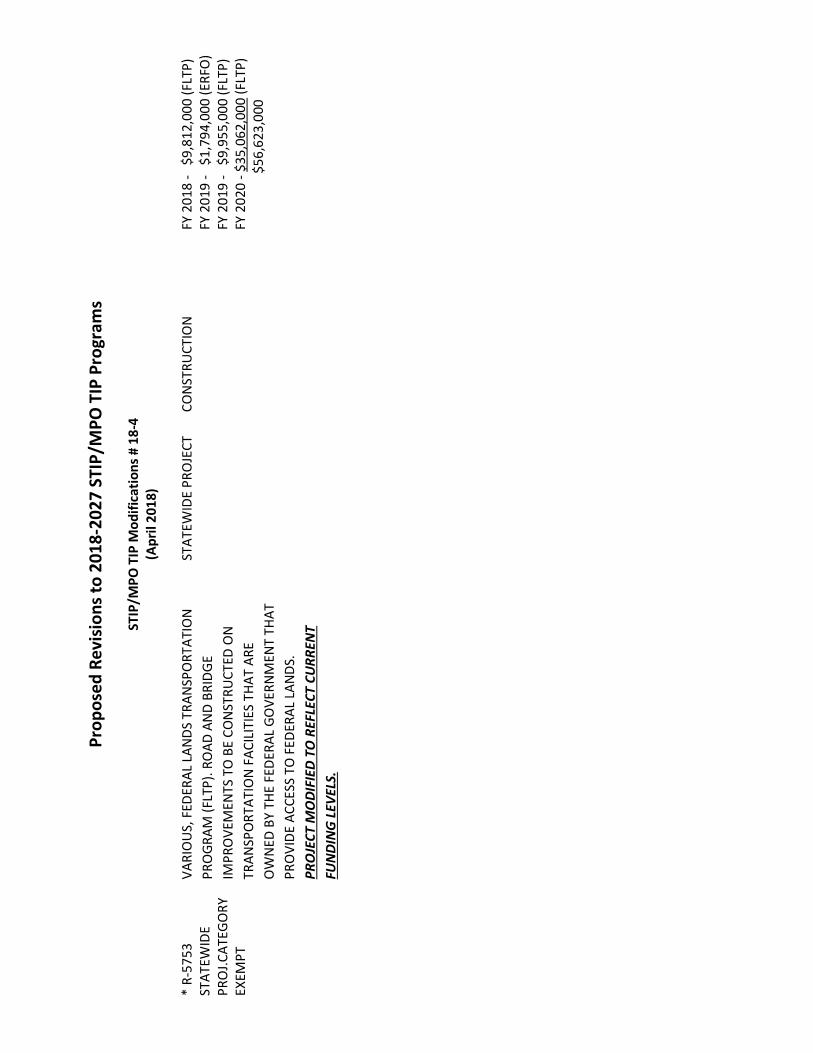
Pr
opos
ed R
evis
ions
to 2
018-
2027
STI
P/M
PO T
IP P
rogr
ams
ST
IP/M
PO T
IP M
odifi
catio
ns #
18-
4 (A
pril
2018
) *
R-57
53
STAT
EWID
E PR
OJ.C
ATEG
ORY
EX
EMPT
VARI
OU
S, F
EDER
AL L
ANDS
TRA
NSP
ORT
ATIO
N PR
OGR
AM (F
LTP)
. RO
AD A
ND
BRID
GE
IMPR
OVE
MEN
TS T
O B
E CO
NST
RUCT
ED O
N
TRAN
SPO
RTAT
ION
FAC
ILIT
IES
THAT
ARE
O
WN
ED B
Y TH
E FE
DERA
L GO
VERN
MEN
T TH
AT
PRO
VIDE
ACC
ESS
TO F
EDER
AL L
ANDS
. PR
OJE
CT M
ODI
FIED
TO
REF
LECT
CU
RREN
T FU
NDI
NG
LEV
ELS.
ST
ATEW
IDE
PRO
JECT
CO
NST
RUCT
ION
FY 2
018
- $
9,81
2,00
0 (F
LTP)
FY
201
9 -
$1,
794,
000
(ERF
O)
FY 2
019
- $
9,95
5,00
0 (F
LTP)
FY
202
0 - $
35,0
62,0
00 (F
LTP)
$56
,623
,000

PROJECT STATUS REPORT April 2, 2018
Project Description The Cape Fear Crossing project is proposed as a roadway extending from the vicinity of US 17 Bypass and I-140 in Brunswick County to US 421 in New Hanover County, including a crossing of the Cape Fear River. The project is programmed in the 2018-2027 STIP for planning and environmental studies only using STPDA funding from the Wilmington MPO. The following list includes tasks during the month of March:
Current Activities • The project team continues to coordinate and correspond with project stakeholders. • Studies for the Traffic Noise Analysis and Air Quality Analysis are ongoing. • The draft Traffic Capacity Analysis has been reviewed by NCDOT and is being revised by the project team. • The project team continues preparation of the Draft Environmental Impact Statement (DEIS). • The project team is currently coordinating with NCDOT on design refinements for the detailed study alternatives.
Upcoming Activities • The project team will revise designs per NCDOT comments and include any design revisions necessary upon finalization of
the Traffic Capacity Analysis. • A newsletter will be sent to notify citizens of the remaining alternatives under study.
Past Activities • The NEPA/Section 404 Merger Team reached concurrence on 11/30/17 to eliminate Alternatives C, F, P, G, J, and V
Freeway. Alternatives B, Q, T, M Avoidance, N Avoidance, and V Widening will be carried forward for detailed study in the DEIS.
• The update to the Natural Resources Technical Report was finalized on 9/19/17. • The Essential Fish Habitat Assessment was finalized on 9/01/17. • Right-of-Way cost estimates and relocation reports have been completed. • The project team received final concurrence from the NEPA/Section 404 Merger Team on Concurrence Point 2A – “Bridging
Decisions and Alignment Review” on 8/17/17. • The NEPA/Section 404 Merger Team reached Concurrence Point 2A – “Bridging
Decisions and Alignment Review” on 5/30/17. • The project team received final concurrence from the State Historic Preservation Office on 5/26/17 regarding Section106
effects on historic resources in the project study area. • The project team presented the status of the project and preliminary alternative impact analysis results to the WMPO TAC
on 3/29/17. • The Archaeological Predictive Model Update was finalized on 2/13/17. • The NEPA/Section 404 Merger Team reached Concurrence Point 1 – “Purpose and Need and Study Area Defined” on
12/12/13; the NEPA/Section 404 Merger Team reached Concurrence Point 2 – “Detailed Study Alternatives Carried Forward” on 2/10/14.
• Technical documents that have been finalized are available on the project website under “Project Documents.”
Contact Information NCDOT – John Conforti, [email protected], 919.707.6015; AECOM – Joanna Rocco, [email protected], 919.239.7179; Website: http://www.ncdot.gov/projects/capefear/; Email: [email protected]; Hotline: 1.800.233.6315
Cape Fear Crossing STIP U-4738
Brunswick and New Hanover Counties

WILMINGTON MPO TRANSPORTATION PLANNING
APRIL 2018 2045 METROPOLITAN TRANSPORTATION PLAN Project Description/Scope: The Wilmington Urban Area Metropolitan Planning Organization is required by federal law to update the Metropolitan Transportation Plan every 5 years. The last plan was adopted by the MPO Board on November 18, 2015. The next update is required to be adopted by November 2020. This plan will guide the regional transportation priorities and actions, and be used for project selection in the State/Metropolitan Transportation Improvement Programs. The MPO Board appointed a Citizen Advisory Committee (CAC) to help guide the development of this plan. The plan update has been branded as Cape Fear Moving Forward 2045. The Cape Fear Moving Forward 2045 Kick-Off Event was held April 3, 2018 from 4-6pm at the NHC Northeast Library. There were approximately 35 people in attendance and the event was covered by multiple media outlets. Remarks were given by Pat Batleman, WMPO Board Vice Chairwoman; Ron Lucas from FHWA; and Laura Padgett, CAC Chairwoman. Next Steps: • Present to the Local Members Boards in April • Regional open houses scheduled for May in Carolina Beach, Leland, Hampstead, and Wilmington • Modal subcommittees to convene in early summer and begin preparations for project lists,
scoring, and ranking. • Adoption in November 2020 LELAND STREET DESIGN STANDARDS MANUAL Project Description/Scope: The Town of Leland is partnering with the Wilmington Urban Area MPO for the development of street design manual. These guidelines will guide new development towards the construction of streets that better align with the town’s values in terms of connectivity, multi-modal activity, maintenance, design, and safety. The Leland Street Design Manual will includes conceptual tables/graphics which will more easily convey the impact of standards on the physical landscape to the public and elected officials. A public meeting was held on December 4th to review the draft materials. The document was revised and a follow-up meeting was held on February 20th. Staff from the MPO and Town continue to work on the development of these standards. Next Steps:
• The Town continues to review the document • Hold a meeting with the development community to discuss the planning effort • Continue to update the guidelines/manual per guidance from the Town of Leland
NORTHEAST NEW HANOVER COUNTY FUTURE STREET PLAN Project Description/Scope: New Hanover County and the Wilmington Urban Area MPO are partnering to develop a Future Street Plan for Northeastern New Hanover County. This plan will serve as a framework for a future street system in the study area by examining how well the existing transportation system performs, developing multi-modal street design guidelines, and creating strategies for integrating land use and transportation development. The MPO and County have received a draft plan from the consultant. The plan will be revised by County and MPO staff to meet our needs.

Next Steps: • Finalize Draft Plan • Present information to New Hanover County Planning Board and Board of Commissioners
SITE DEVELOPMENT REVIEW Project Descriptions/Scope: The Wilmington Urban Area MPO assists with site development and Transportation Impact Analysis review for the MPO’s member jurisdictions. During the last month, staff has reviewed the following development proposals:
• New Hanover County Development Plan Reviews: 9 reviews • New Hanover County Informal Plan Reviews: 3 reviews • New Hanover Concept Reviews: 3 reviews • Town of Leland Formal Reviews: 4 reviews • Town of Leland Informal Reviews: 0 reviews • Town of Navassa Formal Reviews: 0 reviews • Town of Navassa Informal Reviews: 0 reviews • Town of Navassa Concept Reviews: 0 reviews • Town of Carolina Beach Formal Reviews: 0 reviews • Town of Carolina Beach Informal Reviews: 0 reviews • Brunswick County Formal Plan Reviews: 0 reviews • Brunswick County Informal Plan Reviews: 0 reviews • TIA Reviews:10 total (New Hanover County 2, City of Wilmington 7, Carolina Beach 0, Leland 0,
Navassa 1, and Pender County 0) new 2 and ongoing 8 • Pender County Development Plan Reviews: 8 reviews • Pender County Informal Plan Reviews: 2 reviews • Pender County Concept Reviews: 0 reviews • City of Wilmington Formal Reviews: 61 (9 new, 52 on-going) • City of Wilmington Informal Reviews: 16 (2 new, 14 on-going) • City of Wilmington Concept Reviews: 14 ( 10 new concept reviews- 4 on-going concept) • COW Project Releases: 10 Full releases
STBGP-DA/TASA-DA FY 2013, 2014, 2015 and 2016 Project Status STBGP-DA U-5534B - CITY OF WILMINGTON- HEIDI TRASK DRAWBRIDGE Project Descriptions/Scope: This project consists of construction of a public walkway/pier underneath the Heidi Trask Drawbridge to provide for a safe crossing for cyclists and pedestrians across US 74 (Wrightsville Avenue) on the mainland side of the drawbridge in Wilmington. Project Status and Next Steps:
• Construction contract awarded to Intercoastal Marine, LLC • Additional funds approved by the City on September 5, 2017 • Additional modifications being made to the structure to span AT&T locations

U-5534C - WRIGHTSVILLE AVENUE/GREENVILLE AVENUE TO HINTON AVENUE Project Descriptions/Scope: The project is for construction of intersection re-alignment improvements at the intersection of Wrightsville Avenue/Greenville Avenue and bike lanes and sidewalks along Greenville Avenue from Wrightsville Avenue to Hinton Avenue. Project Status and Next Steps:
• 100% plan comments sent back to Engineer • Specifications comments sent back to Engineer • R/W acquisition completed Spring 2018 • Bidding anticipated in Summer 2018
U-5534D - TOWN OF LELAND - OLD FAYETTEVILLE ROAD MUP Project Descriptions/Scope: This project is for design and construction of a ten foot (10') wide multi use path, separate but adjacent to Old Fayetteville Road, beginning at or around the corner of the Leland Town Hall Campus and ending at the driveway of the North Brunswick High School. Project Status and Next Steps:
• Revised 90% plans/ROW plans and project schedule submitted to NCDOT on January 24, 2018 • The Town is working to complete a Supplemental Agreement with NCDOT • NCDOT to determine project ownership • Construction contract let is anticipated June 20, 2018
U-5534E - TOWN OF CAROLINA BEACH - ISLAND GREENWAY AND HARPER AVENUE BIKE LANES Project Descriptions/Scope: This project is for the design and construction of an off-road multi-use path that begins at Mike Chappell Park and winds along the existing cleared fire path and terminates at Alabama Avenue and the Harper Avenue bike lanes will consist of a bicycle boulevard on existing pavement on each side of Harper Avenue from Dow Road to Lake Park Boulevard. The Town desires to combine the project with the awarded 2014 STP-DA project. Contract documents have been approved and are being finalized for advertisement. Initial funding has been approved by the Board and FHWA. Project Status and Next Steps:
• The project is under construction
U-5534F – CITY OF WILMINGTON – PARK AVENUE MUP – PHASE II Project Descriptions/Scope: This project is for the design and construction of an off-road multi-use path between Audubon Boulevard and Kerr Avenue. The right of Way certification was received November 2, 2016. Project Status and Next Steps:
• Plans and Technical specifications have been resubmitted to NCDOT for review • The City has received the proposed Supplemental Agreement from NCDOT for $240,000 • A supplemental agreement was approved in March by the City Council and is being routed for
signatures • Anticipated Let Date: To be determined once bid package approved

U-5534S (Formerly U-5534M)- Coral Drive Sidewalks Project Descriptions/Scope: The construction of sidewalks along Coral Drive will install approximately 954 feet of 5 foot wide sidewalk on Coral Drive adjacent to Wrightsville Beach Elementary. The Town hired SEPI to complete the design. Project Status and Next Steps:
• 65% plans complete. • Awaiting final plans • Anticipated Let Date: Summer 2018
U-5534H – HINTON AVE MULTI-USE PATH Project Descriptions/Scope: This project consists of the construction of a 10' wide multi-use path along Hinton Avenue from Park Avenue to Greenville Avenue. Project Status and Next Steps:
• The City has provided the executed revised scope and amendment to McKim & Creed. • Issues with the plans continue to exist. McKim & Creed is working on revising the plans. • Anticipated Let Date of Fall 2018
U-5534G –HOOKER ROAD MULTI-USE PATH Project Descriptions/Scope: The project consist of the construction of a 10' wide multi-use path along Hooker Road from Wrightsville Avenue to Mallard Drive/Rose Ave intersection Project Status and Next Steps:
• The City has provided the executed revised scope and amendment to McKim & Creed. • Issues with the plans continue to exist. McKim & Creed is working on revising the plans. • Anticipated Let Date of Fall 2018
U-5534K –LELAND MIDDLE SCHOOL SIDEWALK Project Descriptions/Scope: The construction of 5 foot wide concrete sidewalk adjacent to Old Fayetteville Road from Ricefield Branch Rd to the US Hwy 74/76 overpass after Glendale Drive with connections to Leland Middle School and the surrounding neighborhoods. Project Status and Next Steps:
• 90% plans reviewed by NCDOT. Comments are being addressed. • Right of way Certification-TBD • Encroachment agreement will be needed once right-of-way is finalized • Let date will be delayed to match up with “J” project.
U-5534J –OLD FAYETTEVILLE LOOP ROAD PEDESTRIAN LOOP Project Descriptions/Scope: The construction of 5 foot wide sidewalks in three locations: along Village Road from Town Hall Drive going southeast to the existing sidewalk in front of the apartment complex, along Town Hall Drive from Village Road NE to the sidewalk currently under construction by the new Town Hall, and along Old Fayetteville Road from the existing sidewalk in front of the apartment complex to Village Road NE. Project Status and Next Steps:
• The Leland Town Council approved a scope change at their July 2017 meeting
• 90% plans reviewed by NCDOT. Comments being addressed. • Right of way acquisition underway
U-5534I –VILLAGE ROAD MULTI-USE PATH EXTENSION Project Descriptions/Scope: The construction of a 10 foot wide asphalt multi-use path routed across Perry Ave, behind the library, out to Village Road, down Village Road ending on the western edge of the First Baptist Church property before the Sturgeon Creek Bridge. Project Status and Next Steps:
• 90% plans reviewed by NCDOT. Comments are being addressed. • Right of way acquisition underway • Right of way Certification- TBD • Encroachment agreement needed once right-of-way finalized • Let date will be delayed to match up with “J” project.
SHIPYARD BOULEVARD SIDEWALK Project Description/Scope: The construction of a sidewalk and bus pull-out along Shipyard Boulevard between Vance Street and Rutledge Drive. This will be a partnership between the City of Wilmington, Cape Fear Public Transportation Authority and Wilmington MPO. Project Status and Next Steps:
• 100% plans approved by NCDOT • A request for additional funds was approved at the April 3rd City Council meeting. A resolution
will be considered on the April TCC and MPO Board meetings for these additional funds. • Anticipated let date Summer 2018
U-5534O Cape Fear Blvd Multi-Use Path Project Description/Scope: The construction of approximately 3200 linear feet of 10’ wide paved off-road Multi-use Path along the south side of Cape Fear Blvd. from 6th Street to Dow Road. Project Status and Next Steps:
• Bids were opened January 23, 2018. • Additional funds were approved by the MPO. The Town is moving forward with NCDOT on a
supplemental agreement. • Construction to start once additional funds are received
U-5534Q –S. College/Holly Tree Crosswalks Project Description/Scope: The project will install sidewalk, ADA ramps, curb and gutter, markings and traffic signal revisions required to install actuated pedestrian crossings of S. College Road and crossings on Holly Tree Road. Project Status and Next Steps:
• The City will provide additional survey regarding the drainage conflicts – survey update 95% complete
• The project has been put on hold until NCDOT’s resurfacing project moves forward.

U-5534T – Traffic Signal Preemption Project Description/Scope: This project will install traffic pre-emption equipment at 27 locations throughout the City of Wilmington and GPS devices on fire apparatus. Project Status and Next Steps:
• 10% design completed U-5534U – Navassa Park Multi-Use Path Project Description/Scope: This project will construct bike lanes on both sides of Brooklyn Street, a multi-use path connecting Brooklyn Street to the Navassa Park, and a multi-use path through the Navassa Park forming a loop within the park. Project Status and Next Steps:
• Scoping meeting held with NCDOT • PE funds were released at the December 2017 Board of Transportation meeting • PE Advertisement to close on March 15, 2018
TASA-DA U-5527B CITY OF WILMINGTON – 5th AVE INTERSECTION UPGRADES Project Descriptions/Scope: This project is for the construction of high visibility crosswalks, curb ramps, and pedestrian activated signals on 5th Ave at the Dawson Street and Wooster Street intersections. Project Status and Next Steps:
• A supplemental agreement for additional funding was approved by the Wilmington City Council on September 5, 2017.
• The supplemental agreement was approved by the Board of Transportation • The project is over budget. The city will try to rebid this project with the Gregory/Williston Safe
Routes to School project. U-5527C NEW HANOVER COUNTY – MIDDLE SOUND GREENWAY – EXTENSION TO MIDDLE SOUND VILLAGE Project Descriptions/Scope: This project is for the construction of a multi-use path along Middle Sound Loop Road from Oyster Lane to the Middle Sound Village property line. Project Status and Next Steps:
• New Hanover County has selected Davenport Engineering to complete the design. • Davenport manhour estimate has been approved by NCDOT • New supplemental agreement signed allowing for additional funding and time extension to
December 31, 2019
U-5527D HARPER AVE. MULTI-USE PATH Project Descriptions/Scope: The construction of approximately 2104 linear feet of 10’ wide paved multi-use path along Harper Ave. from Dow Road to 6th Street Project Status and Next Steps:
• NCDOT Agreement is in place • PE funds authorized August 2, 2016

• Draft LOI for PE Services submitted and being revised by the Town • Advertisement of PE Services is anticipated in early Summer2018 • Anticipated let date Spring 2019
TRANSPORTATION DEMAND MANAGEMENT PROGRAM Project Description/Scope: UNCW is taking the role as lead employer for the Cape Fear region. The WMPO will coordinate with UNCW to work with other major employers in the region to identify opportunities for public outreach, marketing, carpooling, vanpooling, alternative/compressed work schedules, Emergency Guaranteed Ride Home, park and ride lots, etc. The MPO adopted “Work Cape Fear: Expanding Commuter Options in the Cape Fear Region” TDM Short Range Plan on January 28, 2015 and also authorized staff to apply for a TDM grant through NCDOT that if approved would fund a full-time TDM Coordinator position. The Agreement with NCDOT for the full-time TDM Coordinator position was approved on November 4, 2015. The TDM Coordinator position is currently vacant with the position closing on March 3rd. The MPO held a bike share meeting to discuss the bike-share concept. Next Steps:
• Continue to work with Pulsar on the development of the Go Coast strategic marketing plan. A meeting will be held on May 3, 2018
• Analyze data and results from the Go Coast Commuter Challenge and develop presentations to various groups reflecting our success
• Gather model alternative work schedule policies from various regional employers to be highlighted in the statewide initiative to showcase model alternative work schedules
• Schedule lunch and learns/presentations with area employers to promote Go Coast program • Partner with large employers to determine vanpool options • Partner with UNCW, Cape Fear Community College, and New Hanover Regional Medical Center
to explore carpool matching options and guaranteed ride home strategies • Coordinate with employers to implement 2 additional vanpool programs and potential Park &
Ride lot locations • Conduct Bike Share interviews

Cape Fear Public Transportation Authority Project Update
April 2018
REGIONAL AUTHORITY PROJECTS 1. Bus fleet replacement - identifying state and federal funding opportunities to replace
eleven thirty-five foot buses, two trolleys, and three shuttles. The Authority has applied for funding from a nationwide discretionary grant program from Federal Transit and is working with the WMPO, City of Wilmington and NCDOT to identify opportunities regarding the allocation of $92M in VW settlement funding.
2. Short Range Transportation Plan - following adoption of Cape Fear Transportation 2040 by the Wilmington Metropolitan Planning Organization (WMPO), Wave Transit is completing its latest short range plan. The plan will set a course for public transportation initiatives, route structure, and revenue programming for the next five years. The plan will also include a financial element to ensure that transit programs are compliant with FTA rules and regulations.
Under the direction of the Authority’s Operations and Planning Committee made up of funding partners, Board members, staff, WMPO board members, WMPO staff, passengers, interested citizens, and professional transit planning consultants, the plan is an important tool in identifying and quantifying the public transportation needs of the community. Marketing, public relations, and community support for financing transit in Southeastern North Carolina will also be a focus of the plan. A key component of the plan will be extensive surveying and data collection to assess the needs of current and prospective passengers. Nelson Nygaard is the principal consultant leading the project. Data collection has begun and is being analyzed. Over fifteen agencies are assisting Wave Transit as stakeholders in the planning effort. The stakeholder committee has been identified and held their multiple meeting. The project is expected to be completed in the spring of 2018. The draft plan was presented to the Authority Board on March 22, 2018. Draft recommendations are available at the following URL: https://www.wavetransit.com/short-range-transit-plan/. Changes to the Wave Transit routes based on recommendations from the consultant will be developed over the summer and fall with implementation in late 2018 to coincide with the opening of the Wilmington Multimodal Transportation Center.
3. Long Term Funding - currently, the Authority does not have a dedicated source of local funding. A consultant led study to evaluate the governing model and long term funding for transit in the region has been commissioned by the City of Wilmington and New Hanover County. TransPro Consulting has been retained to undertake the effort.
4. Shelter Program - a program to replace and add up to 50 bus shelters and 25 benches at bus stops is underway. Construction of the first eight shelters is complete. Phase two, consisting of 12 shelters and 15 benches is currently under construction. Phase three

consisting of super stops at Hanover Center, and Monkey Junction is in the engineering and permitting phase.
Wave Transit is in discussion with the owners of Independence Mall to include transit improvements in coordination with redevelopment of the property.
WMPO SPONSORED PROJECTS
1. Wilmington Multimodal Transportation Center - an Interlocal Agreement between Authority, City of Wilmington, WMPO, and NCDOT has been executed. Demolition of the U-Haul building is complete. Thanks to generous support from the WMPO, STP-DA funding in the amount of $2,400,000 has been flexed by FHWA to FTA for the project and a formal grant with FTA has approved. Phase 1 consisting of hazardous materials abatement and demolition is complete. Phase 2 consisting of building stabilization is complete. Phase 3 consisting of renovation construction was let for bidding on February 14, 2018. Bids for Phase 3 were opened on March 13, 2018. On March 22, 2018, the Authority resolved to reject all bids due to the lowest bid exceeding available funds for the project. The Authority is developing plans to move the project forward.
2. Preventive Maintenance & ADA - STBGP-DA funding in the amount of $510,778 for preventive maintenance and ADA service throughout the region was approved by the WMPO in 2016. The process of flexing the funds from FHWA to FTA is complete and a grant for the funding has been submitted to FTA. The funds will assist the Authority in maintaining its fleet of fixed route buses and FTA funded facilities to meet the FTA State of Good Repair Requirement. The preventive maintenance funding will ensure that Wave Transit vehicles are safe, reliable, and provide a positive and comfortable experience on Wave Transit routes throughout the region.
Americans with Disabilities Act (ADA) compliance utilized under the funding will be used to offset the cost of providing complementary ADA service for passengers unable to access Wave Transit fixed routes. Paratransit services provided under the WMPO authorized funding include specialized origin to destination van service. In February 2018 the Authority provided 1,464 ADA passenger trips. The period of performance for the project is 07/01/2017 through 06/30/2018.
3. Replacement CNG Buses - (no change) In February 2017 the WMPO appropriated $744,000 in FHWA funding for two replacement CNG buses. The Authority has a contract for the vehicles with Gillig, LLC. A purchase order for the buses was approved by the Authority on June 22, 2017. Local matching funds have been appropriated by the City of Wilmington. The estimated delivery date is May 2018 for both vehicles.

STATE OF NORTH CAROLINA
DEPARTMENT OF TRANSPORTATION ROY COOPER JAMES H. TROGDON, III
GOVERNOR SECRETARY
April 6, 2018 WMPO Project Update List
Project Update List for New Hanover County
Projects Under Construction
Contract C203922: Greenfield Lake: Realign and upgrade intersection at SR 1436/US 421 and SR 1140 (Burnett Blvd.) south of Willard Street. Original traffic pattern open December 2017
Contractor has completed the culvert. Full intersection opened to Traffic Sewer line work away from traffic remains. Contractor working on punch list items. Punch list completion tentatively end of February
Contractor: Mountain Creek Contractors Inc. Bid Amount: $3,156,247.36 Completion Date: February 28, 2018 Percent Complete: 100.0% R-2633 BA – (Wilmington Bypass: C203199) construct a 4-lane divided highway from US 74/76 (near Malmo) to SR 1430 (Cedar Hill Road). Open to traffic on December 18, 2017. Work will continue to Mt. Misery and Cedar Hill Road until Spring of 2018. Roadway: • Working on guardrail/guiderail. • Working on grading approach slabs for last incomplete structures on mainline. Contractor: Barnhill Contracting Estimated Completion Date: June 2018 Percent Complete: 88.6% R-2633 BB – (Wilmington Bypass: Bridge over Cape Fear River: C203198) construct a 4-lane divided highway from SR 1430 (Cedar Hill Road) to US 421 (where I-140 currently ends in New Hanover County…this includes the large bridge over the Cape Fear River). Open to traffic on December 18, 2017. • 90% complete on the roadway portion of the project. Contractor: Balfour Beatty Infrastructure Estimated Completion Date: June 2018 Percent Complete: 99.7%
State of North Carolina | Department of Transportation | Division of Highways 5501 Barbados Boulevard | Castle Hayne, NC 28429-5647
910-341-2000 T

B-5103: (C203540) replace bridge #35 over the abandoned railroad on SR 1627 (3rd Street), in Wilmington. Bid Amount: $4,640,453.87 Percent Complete: 99.9%. Waiting on final estimate. U-3338B: (C203772) Widening of Kerr Ave. from Randall Parkway to MLK, Jr. Prkwy. Installing storm drain throughout project, and grading Multi-Use Path at Kerr and Randall Prkwy.
Multi-Use path at Kerr Ave. and Randall Prkwy. is paved. • Mast arm for traffic signal has been installed at Kerr Ave. and Randall Prkwy. Contractor: Sealand Contractors Corp. Bid Amount: $22,000,000.58 Estimated Completion date: November 2018 Percent Complete: 62.9% B-5236: (C203957) Replace Bridge #19 over Lords Creek on SR-1100 Start Date: November 2017 Anticipated Completion date: November 2018 Percent Complete: 24.5% U-4751: (C203980) Military Cutoff Road Extension: extending Military Cutoff Road from Market Street to the Wilmington Bypass, with an interchange at the Bypass west of US 17 Business (Market Street) to US 17 Business (Market Street) SR 1403 (Middle Sound Loop Road). Realignment of Lendire Road complete. Construction forecasted from FY2017 - FY2022
PNB is working on lowering their gas line throughout the project Spectrum boring and pulling cable Duke Energy working on clearing and installing power poles Precon was on Tuesday January 9, 2018 Survey party finish staking wetland boundary for Duke clearing crews.
Anticipated Completion date: April 2022 Percent Complete: 2.6%
Project Development
R-5021: widening of NC 211 from NC 87 to SR 1500 (Midway Road) to a 4-lane divided facility. Let Date June 2018 U-4902 C&D: US 17 Business (Market Street) construct a “superstreet” (median) from SR 2734 (Marsh Oaks Drive) to Lendire Drive & from Station Road to US 74 (MLK Parkway/Eastwood Road). Let Date October 2018 B-4590: replace bridge #29 over Smith Creek on NC 133 (Old Castle Hayne Road) Let Date December 2018 U-5710: US 74 (Eastwood Road) from Burnett Avenue to US 117 (Shipyard Blvd) upgrade the roadway. Let Date July 2021
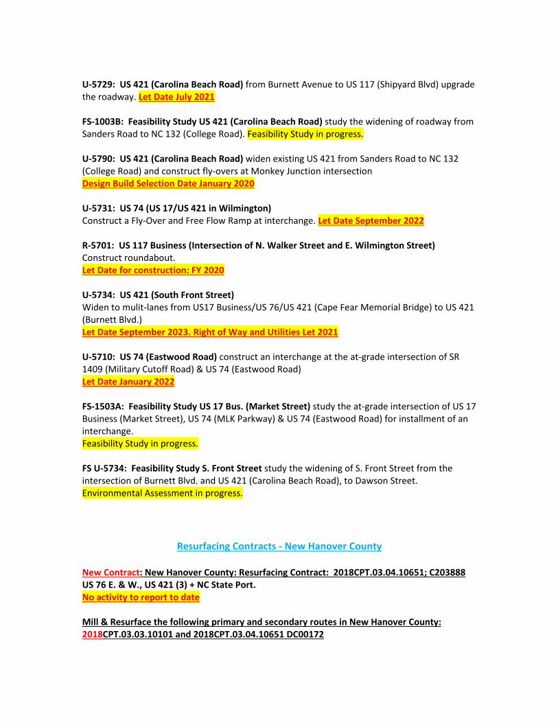
U-5729: US 421 (Carolina Beach Road) from Burnett Avenue to US 117 (Shipyard Blvd) upgrade the roadway. Let Date July 2021 FS-1003B: Feasibility Study US 421 (Carolina Beach Road) study the widening of roadway from Sanders Road to NC 132 (College Road). Feasibility Study in progress. U-5790: US 421 (Carolina Beach Road) widen existing US 421 from Sanders Road to NC 132 (College Road) and construct fly-overs at Monkey Junction intersection Design Build Selection Date January 2020 U-5731: US 74 (US 17/US 421 in Wilmington) Construct a Fly-Over and Free Flow Ramp at interchange. Let Date September 2022 R-5701: US 117 Business (Intersection of N. Walker Street and E. Wilmington Street) Construct roundabout. Let Date for construction: FY 2020 U-5734: US 421 (South Front Street) Widen to mulit-lanes from US17 Business/US 76/US 421 (Cape Fear Memorial Bridge) to US 421 (Burnett Blvd.) Let Date September 2023. Right of Way and Utilities Let 2021 U-5710: US 74 (Eastwood Road) construct an interchange at the at-grade intersection of SR 1409 (Military Cutoff Road) & US 74 (Eastwood Road) Let Date January 2022 FS-1503A: Feasibility Study US 17 Bus. (Market Street) study the at-grade intersection of US 17 Business (Market Street), US 74 (MLK Parkway) & US 74 (Eastwood Road) for installment of an interchange. Feasibility Study in progress. FS U-5734: Feasibility Study S. Front Street study the widening of S. Front Street from the intersection of Burnett Blvd. and US 421 (Carolina Beach Road), to Dawson Street. Environmental Assessment in progress.
Resurfacing Contracts - New Hanover County
New Contract: New Hanover County: Resurfacing Contract: 2018CPT.03.04.10651; C203888 US 76 E. & W., US 421 (3) + NC State Port. No activity to report to date Mill & Resurface the following primary and secondary routes in New Hanover County: 2018CPT.03.03.10101 and 2018CPT.03.04.10651 DC00172

US 17 Bus. East/US 76 East – Ocean Hwy E. from New Hanover County Line northwest past underpass. US 17 Bus. W/US 76 West – Ocean Hwy E. US 421 N. Ramp – From US 421 to off ramp onto US 76/421 US 17 Bus. E./US 76 E. (US Hwy. 74/76) – From New Hanover County Line to Cape Fear Memorial Bridge. Bridge #13. US 17 Bus. W./US 76 W (US Hwy. 74/76) - From New Hanover County Line to Cape Fear Memorial Bridge. Bridge #13. US 421 N. (Carolina Beach Rd.) – From Snows Cut Bridge, north to SR 1187 (Sanders Road). US 421 S. (Carolina Beach Rd.) – From Snows Cut Bridge south to SR 1187 (Sanders Road). NC 132 N. (South College Rd.) – near SR 1521 (Piner Road) north to 17th Street. NC 132 S. (South College Rd.) – From 17th Street south near SR 1521 (Piner Road). SR 1318 (Blue Clay Rd.) – From the intersection of SR 1302 (23rd St.) and Blue Clay Rd. north to the intersection of Blue Clay Rd. and N. College Rd. SR 1492 (Myrtle Grove Rd.) SR 1333 (Hermitage Rd.) – From NC 133 to SR 2157 (Crowatan Rd.) SR 2158 (Hermitage Rd.) – From SR 2157 (Crowatan Rd.) to end of road. SR 2157 (Crowatan Rd.) – From NC 133 to SR 1333 (Hermitage Rd.) SR 2159 (Chesterfield Rd.) – From end of SR 1333 (Hermitage Rd.) to end of SR 2159 (Chesterfield Rd.) SR 2228 (Dekker Rd.) SR 1317 (Chadwick Ave.) – From Castle Hayne Rd. to end of SR 1317 (Chadwick Ave.) SR 2697 (Memory Lane) – From Bountiful to end of SR 2697 (Memory Lane). SR 1852 (Shore Point Dr.) SR 1853 (Conch Dr.) SR 1882 (Abalone Dr.) (Coquina Dr.) and (Cowrie Lane) – Located off of Edewater Club Dr. in Porters Neck. SR 2908 (Conquina Dr.) – Located off of Edewater Club Dr. in Porters Neck. SR 2537 (Duck Downe Ct.) SR 2023 (Diamond Shamrock Rd.) – Located off of SR 1002 (Holly Shelter Rd.)
SR 1823 (Kenmore Dr.) – Located off of SR 1403 (Middle Sound Loop Rd.) SR 1824 (Brandywine Circle) – Located off of SR 1403 (Middle Sound Loop Rd.) SR 1826 (Homestead Ct.) – Located off of SR 1403 (Middle Sound Loop Rd.) SR 1825 (Salem Ct.) – Located off of SR 1403 (Middle Sound Loop Rd.) SR 2024 (Krauss Ln.) – Located off of Division Dr.
SR 2322 (Walker Ridge Ct.) - Located off of Carolina Beach Rd. (North) SR 2326 (Bainbridge Ct.) - Located off of Carolina Beach Rd. (North) SR 2327 (Alden Ct.) - Located off of Carolina Beach Rd. (North) SR 2021 (Wordsworth Dr.) – Located off of North College Rd. SR 2168 (Pine Knolls Rd.) – Located off of SR 1322 (Murrayville Rd.) SR 2733 (Miranda Ct.) – Located off of W. Northchase Prkwy. SR 2732 (Lakemoor Dr.) – Located off of W. Northchase Prkwy. SR 2230 (Edward Hyde Place) – Located off of W. Northchase Prkwy. SR 2231 (John Yeamen Rd.) – Located off of SR 2230 (Edward Hyde Place) SR 2730 (Nevan Ln.) – Located off of W. Northchase Prkwy.

SR 2004 (Kings Dr.) – Located off of N. Coillege Rd. SR 2264 (Jason Ct.) SR 2657 (William Louis Dr.) SR 2658 (Brandy Ct.) SR 1375 (Lockwood Dr.) SR 1376 (Glenlea Dr.) SR 1374 (Alandale Dr.) – Located off of N. Kerr Ave. SR 1377 (Lynbrook Rd.) SR 2206 (W. Northcahse Prkwy.) – Located on N. College between SR 2257 (SE Northchase Prkwy.) and SR 2652 (NE Northchase Prkwy.) SR 2767 (Ammons Drive) – Located off of W. Northchase Prkwy.
SR 2234 (Brittany Rd.) – Located off of SR 1322 (Murrayville Rd.) SR 2235 (Creek Ridge Rd.) – Located off of SR 1322 (Murrayville Rd.) SR 2117 (Shenandoah St.) – Located off of SR 1322 (Murrayville Rd.) SR 2072 (Kerry Dr.) – Located off of Holly Shelter Rd. SR 2073 (McGregor Rd.) – Located off of Holly Shelter Rd. SR 2074 (Berwick Dr.) – Located off of Holly Shelter Rd. NC State Port Authority (Patching) SR 1971 (Humphrey Dr.) SR 1345 (Alexander Rd.) – Located off of Market Street SR 1923 (Lost Tree Rd.) – Located off of N. Market Street
SR 1930 (Bright Leaf Rd.) SR 1979 (Harlandale Rd.) SR 1989 (Haven Way) – Located off of Middle Sound Loop Rd.
Following roads are located off of SR 2048 (Gordon Rd.) SR 2622 (Bay Blossom Dr.)
SR 2626 (Winter Moss Ln.) SR 2665 (Hopscotch Dr.) SR 2666 (Sapling Circle) SR 2667 (Splitbrook Ct.) SR 2672 (Loblolly Ct.) Mill & resurface the following primary routes in New Hanover County: 2017CPT.03.07.20651. DC00172
SR 1318 (Blue Clay Rd.) – from radius at intersection of SR 1322 (Kerr Ave.) to pvmt seam at US 117. 2.89 miles. SR 1324 (Sheridan Dr.) – from NC 133 to SR 1325 (Long Leaf Drive). SR 1325 (Long Leaf Dr.) – from SR 1326 (Laurel Drive) to SR 1358 (Holland Drive). SR 1326 (Laurel Dr.) – from SR 1358 (Holland Drive) to dead end. SR 1332 (Chair Rd.) – from NC 133 west on NC 133. SR 1382 (Garden Place Dr.) – from NC 132 to SR 1387 (Hyacinth Ave.) SR 1383 (Wedgewood Rd.) – from SR 1382 (Garden Place Dr.) to dead end. SR 1387 (Hyacinth Ave.) – from SR 1382 (Garden Place Dr.) to dead end. SR 1668 (Balsam Dr.) – from SR 1667 (Hickory Knoll Dr.) to SR 1668 (Balsam Dr.). SR 1669 (Darley Ln.) – from SR 1667 (Hickory Knoll Dr.) to SR 1686 (Royal Oak Dr.) SR 1686 (Royal Oak Dr.) – SR 1492 (Myrtle Grove Rd.) to SR 1667 (Hickory Knoll Dr.)

SR 2071 (Arlene Dr.) – from NC 133 to end of maintenance. SR 2181 (Blue Clay Rd. / Dairy Farm Rd.) – from SR 1002 (Holly Shelter Rd.) to SR 1336 (Sidbury Rd.). SR 2199 (Creekstone Ln.) – from SR 1335 (Parmele Rd.) to end of maintenance. SR 2200 (Plum Tree Lane) – from SR 2199 (Creekstone Ln.) to end of maintenance. SR 2501 (Access Rd. to Monkey Jct.) – from US 421 to US 421. SR 1322 (Murrayville Rd.) – from SR 2234 (Brittany Rd.) to SR 2691 (Retriever Dr.). SR 2313 (Wilshire Blvd.) – from west of SR 1175 (Kerr Ave.) to east of Rosemont Ave. SR 1400 (Flutch Creek Rd./Champ Davis Rd.) – from south of SR 2845 (Market Street) to SR 1491 (Porters Neck Rd.) SR 2652 (Northchase Pkwy. NE) – from US 117 to cul-de-sac
Estimated Completion Date: February 2018 Percent Complete: 95.7% Mill & resurface the following primary routes in New Hanover County:
US 421 (Carolina Beach Road) – from 0.26 miles south of Independence Blvd. (non-system portion) to west of Lake Shore Drive (non-system) US 117 Northbound Lanes (Shipyard Blvd) – from US 421 to 0.05 miles east of US 421 (Carolina Beach Road) US 117 Southbound Lanes (Shipyard Blvd) – from 0.20 miles east of US 421 to US 421 (Carolina Beach Road) US 421 Southbound Lanes (South 3rd Street) – from US 76 (Dawson Street) to Greenfield Street (non-system) US 421 Northbound Lanes (South 3rd Street) – from Greenfield Street (non-system) to US 76 (Dawson Street US 17 Business (South 3rd Street) – from US 76 eastbound lanes to US 76 westbound lanes.
Mill & resurface the following secondary routes in New Hanover County:
SR 1218 (16th Street) – from US 76 westbound lanes (Wooster Street) to US 76 eastbound lanes (Dawson Street) SR 1371 (16th St.) - from Grace Street (non-system) to US 17 Business (Market Street) SR 2816 (16th St.) - from US 17 Business (Market Street) to US 76 westbound lanes (Wooster Street) SR 1301 (17th Street) - from US 17 Business (Market Street) to Grace Street (non-system) SR 2817 (17th Street) - from US 76 eastbound lanes (Dawson Street) to US 17 Business (Market Street) SR 1411 (Wrightsville Avenue) - from Dawson Street Extension (non-system) to SR 1209 (Independence Blvd.)
Resurface the following secondary routes in New Hanover County:
SR 2699 (Amsterdam Way) - from SR 2700 (Old Dairy Rd.) to SR 2048 (Gordon Rd.) SR 2701 (Antilles Ct.) - from SR 2698 (Netherlands Dr.) to end maintenance SR 2698 (Netherlands Dr.) - from SR 2048 (Gordon Rd.) to SR 2700 (Old Dairy Rd.)

SR 2700 (Old Dairy Rd.) - from US 17 Bus. (Market St.) to SR 2699 (Amsterdam Way) SR 2220 (Windmill Way) - from SR 2219 (N. Green Meadows Dr.) to SR 2700 (Old Dairy Rd) SR 2183 (Spring Rd) - from NC 133 (Castle Hayne Rd.) to SR 2184 (Fairfield Rd.) SR 2184 (Fairfield Rd.) - from SR 2183 (Spring Rd) to SR 1318 (Blue Clay Rd)
Widen & resurface following routes in New Hanover County:
SR 1940 (Covil Farm Rd) - from SR 1409 (Military Cut-Off Rd) to SR 1916 (Red Cedar Rd) SR 2717 (Torchwood Blvd.) - from US 17 Bus. (Market St.) to SR 2718 (Beacon Dr.) Mill & resurface a section & just resurface another section of SR 1363 (Bayshore Dr.) from US 17 Bus. (Market St.) to SR 1393 (Biscayne Dr.)
New Hanover:
I-40 – milling & resurfacing from Gordon Road interchange to NC 210 interchange I-40 – milling & resurfacing from US 117 interchange to mile post 393 (approximately
3.5 miles east of US 117 interchange) No activity to report to date New Hanover County: Resurfacing Contract: C203868, I-5760
I-140 (Wilmington Bypass) resurface from I-40 to US 421 & reconstruction of bridge approaches, joint repair & signals.
Contractor: Barnhill Contracting Company Estimated Contract Completion Date: March 2018 Percent Complete: 73.0% New Hanover County: Resurfacing Contract: 2017CPT.03.01.10651; C203888 US 117/NC 132 (College Road) from US 17 Business (Market Street) to
SR 2313 (Wilshire Blvd.) WBS #36249.3622; C203888 City of Wilmington signal plan modifications & work to install pedestrian upgrades at the intersection of US 117/NC 132 (S. College Road) and SR 2313 (Wilshire Blvd) to US-17 Business. Includes safety projects: W-5203AA construct offset left turn lanes on College Road & Hurst/Hoggard Drive upgrade pedestrian facilities to high visibility crosswalks w/ countdown pedestrian heads. Extend sidewalk to connect with existing sidewalk. W-5601BB install high visibility crosswalks & push button pedestrian signals at the intersection of College Road & New Center Drive. Contractor: Barnhill Contracting Company Estimated Contract Completion Date: February 2018 Percent Complete: 44.2%.

Project Update List for Brunswick County
Projects Under Construction
ER-2971: (DC00194) Ocean Isle Beach Roundabout – Hwy 179 (Beach Drive) at Hwy 904 (Causeway Drive) SR 1184 (Ocean Isle Beach Road) in Ocean Isle Contractor: Triangle Grading & Paving Inc. Bid Amount: $1,849,999.35 Estimated Completion Date: May 2018 Percent Complete: 21.2%
Proposed Projects
R-5021: widening of NC 211 from NC 87 to SR 1500 (Midway Road) to a 4-lane divided facility. Let Date June 2018
U-5788: US 17 Business (Main Street) Realign intersection at Wall Street and Shallotte Avenue Let Date ROW: FY 2018, construction: FY: 2020 U-5862: US 17 (Shallotte Bypass) Upgrade intersection to interchange SR 1357 (Smith Avenue) Let Date ROW and construction: FY: 2020 U-5914: NC 133 Modernize Intersection at US 17/US 74/ US 76 to SR 1554 (Old River Road). Let Date construction: FY: 2020 U-5932: US 17 Convert Intersection to Interchange. Let Date construction: FY: 2024 R-3436: Carolina Bays Parkway Extension Project Overview and Purpose The N.C. Department of Transportation, along with the S.C. Department of Transportation, is planning to build a multi-lane expressway that extends Carolina Bays Parkway (S.C. 31) from S.C. 9 in Horry County, S.C., across the North Carolina state line to U.S. 17 in Brunswick County. The extension would provide a more direct and efficient movement of traffic seeking to bypass congestion within the areas of Calabash in North Carolina as well as Little River and the Grand Strand areas in South Carolina. It would also improve traffic flow and safety at the intersection of S.C. 9 and S.C. 57 and provide a more direct route for coastal truck traffic moving through North Carolina. Project Highlights

A team of engineering firms, led by CALYX Engineers and Consultants, is under contract to conduct project development and environmental studies, which are being led by NCDOT and SCDOT in cooperation with local, state and federal agencies in both states. Project development and environmental studies are underway to evaluate potential routes for the roadway from an engineering and environmental standpoint and to select a preferred route. Although the project is funded for study, no schedule has been established for right-of-way acquisition or construction, which is not currently funded in North Carolina. ● Capacity analysis for the existing roadways is about to get underway. They will be looking at
current and future conditions.
Resurfacing Projects - Brunswick County Resurfacing Contract: C203923, 2017CPT.03.06.10101 & 2017CPT.03.06.20101 Brunswick County primary routes: 1 Section of US 74/US 76, 2 Sections of NC 87, NC 179, NC 904/179, and 41 Sections of secondary roads. Contractor has started widening on 74/76, and starting to mill and fill on 74/76. Contractor is close to completing mill and fill in Calabash at Beach Drive SW. Estimated Completion Date: May 2018 Percent Complete: 95.4% Resurfacing Contract: I-5357, C203630, WBS #46176.3.FS1, Brunswick County secondary routes:
SR 1104 (Beach Drive) – patching, milling, resurface & leveling from beginning of curb & gutter section to end of SR 1104 SR 1828 (Kings Lynn Drive) – patching, mill & resurface from SR 1104 (West Beach Drive) to SR 1828 SR 1401 (Galloway Road) – resurface from US 17 to SR 1402 (Randolphville Road) SR 1435 (North Navassa Road) – patching, mill & resurface from SR 1472 (Village Road Northeast) to SR 1432 (Old Mill Road Northeast) SR 1430 (Cedar Hill Road) – patching, mill & resurface from SR 1435 (North Navassa Road) to 0.58 miles south of SR 1431 (Royster Road Northeast) SR 1430 (Cedar Hill Road) – patching, mill & resurface from 0.54 miles north of SR 1431 (Royster Road Northeast) to SR 1426 (Mount Misery Road Contractor: S.T. Wooten Percent Complete: 100.0%. Waiting on final estimate
New Contract: Resurfacing Contract: WBS: 2018CPT.03.03.10101, Brunswick County US 76 E. & W., US 421 N., NC 130, NC 179, NC 904. No activity to report to date

Project Update List for Pender County
Under Construction
B-4929: (C203789) Bridge @ Surf City NC 50/210 - replace bridge #16 over the inter-coastal waterway with a fixed span high rise structure. Contractors placed concrete at the following locations: Bent 19, Pier’s 6 and 8, Bent 20, Pier’s 6 and 8. Contractors placed concrete at span A of the bridge deck. Contractors placed concrete at the Bent 12 columns. Contractor: Balfour Beatty Infrastructure Bid Amount: $53,651,508.35 Estimated Contract Completion Date November 2020 Percent Complete: 59.3%
Project Development
R-3300B: US 17 Hampstead Bypass: Construct a four lane divided roadway on mostly new location from NC 210 to Sloop Point Loop Road. R-3300B currently funded in DRAFT 2018-2027 STIP. ROW and Utilities: FY 2018 – FY 2020. Let date for construction: FY 2020 U-5732: Hampstead Median Project: US 17 (Ocean Highway in Hampstead) Convert to superstreet from SR 1582 (Washington Acres Road) to SR 1563 (Sloop Point Loop Road). Median project has been combined with Hampstead Bypass to accelerate the completion of the Bypass. Let Date September 2020
R-3300B: project may be accelerated to build and open the Bypass for use as a detour during the median project construction. Dan Owen Drive connector to Factory Road: Roadway being constructed to alleviate traffic volume off of Hampstead Median Project while being built and to reduce the number of vehicle crashes. Currently staking ROW. NCDOT to construct connector road in 2018. R-3300A: US 17 Hampstead Bypass: Construct a four lane divided roadway from NC 210 to I-140 south of Hampstead. Currently unfunded section of Hampstead Bypass. However, Design and Right of Way has been approved. NCDOT is pursuing funds to meet the same construction let date as R-3300B. U-5732: US 17 (Ocean Highway in Hampstead) Convert to superstreet from SR 1582 (Washington Acres Road) to SR 1563 (Sloop Point Loop Road). Note: Will be built in conjunction with Hampstead Bypass. Let Date September 2020
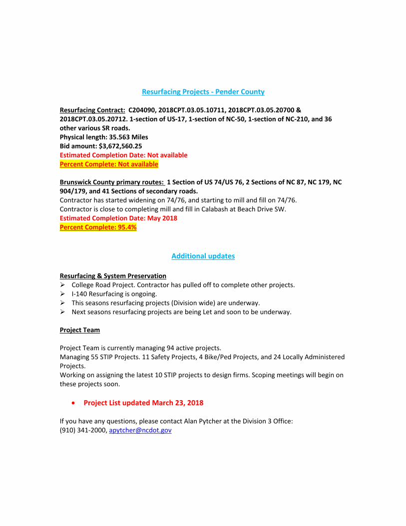
Resurfacing Projects - Pender County Resurfacing Contract: C204090, 2018CPT.03.05.10711, 2018CPT.03.05.20700 & 2018CPT.03.05.20712. 1-section of US-17, 1-section of NC-50, 1-section of NC-210, and 36 other various SR roads. Physical length: 35.563 Miles Bid amount: $3,672,560.25 Estimated Completion Date: Not available Percent Complete: Not available Brunswick County primary routes: 1 Section of US 74/US 76, 2 Sections of NC 87, NC 179, NC 904/179, and 41 Sections of secondary roads. Contractor has started widening on 74/76, and starting to mill and fill on 74/76. Contractor is close to completing mill and fill in Calabash at Beach Drive SW. Estimated Completion Date: May 2018 Percent Complete: 95.4%
Additional updates
Resurfacing & System Preservation College Road Project. Contractor has pulled off to complete other projects. I-140 Resurfacing is ongoing. This seasons resurfacing projects (Division wide) are underway. Next seasons resurfacing projects are being Let and soon to be underway. Project Team Project Team is currently managing 94 active projects. Managing 55 STIP Projects. 11 Safety Projects, 4 Bike/Ped Projects, and 24 Locally Administered Projects. Working on assigning the latest 10 STIP projects to design firms. Scoping meetings will begin on these projects soon.
• Project List updated March 23, 2018 If you have any questions, please contact Alan Pytcher at the Division 3 Office: (910) 341-2000, [email protected]

STATE OF NORTH CAROLINA DEPARTMENT OF TRANSPORTATION
ROY COOPER JAMES H. TROGDON, III GOVERNOR SECRETARY
April 2018 Nazia Sarder Transportation Engineer NCDOT Transportation Planning Division 1 South Wilmington Street Raleigh, NC 27601
MARCH TPD UPDATES WILMINGTON MPO
April 2018
Wilmington Model Update – Wilmington MPO has requested that TPD update their model to a base year of 2015, previously the base year was 2010. The model is being updated so it can be accurately used in the next MTP. We are working on incorporating Base Year SE Data Verification. Once that is completed, the Board will adopt the base year data and we will move onto future year data. Wilmington CTP – With the model update, WMPO has also asked TPD to start on the Wilmington CTP update. We have yet to develop a schedule for this CTP and start – but will develop one in the next few weeks. CTP 2.0 – The CTP 2.0 work is ongoing. TPD has given updates to many RPOs, MPOs and NCDOT employees that were involved in this process end of February. Performance Measures – Performance management is a strategic approach that uses system information to make investment and policy decisions to achieve transportation system performance goals. TPD will be developing a committee with MPO and RPO representatives to establish targets and other requirements. NCDOT informed the MPOs via email on October 19, 2017 about the established safety targets. MPOs are reminded that they must establish safety targets by February 27, 2018.
Mailing Address: NC DEPARTMENT OF TRANSPORTATION TRANSPORTATION PLANNING BRANCH 1554 MAIL SERVICE CENTER RALEIGH NC 27699-1554
Telephone: (919) 707-0900 Fax: (919) 733-9794
Customer Service: 1-877-368-4968
Website: www.ncdot.gov
Location: 1 SOUTH WILMINGTON STREET
RALEIGH, NC 27601

Statewide Plan: TPD has selected WSP as the consultant for the Statewide Plan. A scope and schedule will be developed soon. As stakeholders, MPO/RPOs will be engaged throughout the process. Corridor Studies: Work is underway on the first two master plans, as follows:
• Bundle #1 has been assigned to Kimley-Horn and includes Corridor P (Future I-42/US 70E/ NCRR from I-440 in Wake County to Port at Morehead City), Corridor S (I-795/US 117 from I-95 in Wilson County to I-40 in Sampson County), and Corridor X (US 258/NC 11/US 13 from US 17 in Onslow County to US 64E in Edgecombe County)
• Bundle #2 has been assigned to Atkins, and includes Corridor U (US 74W/US 74E/I 74 from I-26 in Polk County to US 117 in Wilmington) and Corridor D (US 321/CSX from South Carolina state line to Tennessee state line).
Freight Plan: The Statewide Freight Plan was adopted by the BOT in September 2017 and approved by FHWA on November 21, 2017. It can be found online at https://connect.ncdot.gov/projects/planning/Statewide-Freight-Plan/Pages/default.aspx. CMAQ: Applications for funding in FFY 2019 are due in by March 15, 2018. Traffic Forecast: The TF Shapefile is currently “live” and being updated monthly: NCDOT Traffic Forecasting Data. Processes are currently being established in order to allow for the download of approved traffic forecasts from ArcGIS online. A Traffic Forecasts library has been established on the Connect NCDOT site (Traffic Forecasts Connect NCDOT Library). This library is currently a work-in-progress but will ultimately be a place to store and link-to approved traffic forecasts. AQ Conformity: The Conformity Determination Report for the 2045 Metropolitan Transportation Plans for the Metrolina region is out for public comment. We are on track for federal approval of the conformity determination on May 2, 2018.