technical report - rockhaven resourcesjun 05, 2018 · earlier mineral resource model, and the...
TRANSCRIPT
AMC Mining Consultants (Canada) Ltd. BC0767129
200 Granville Street, Suite 202
Vancouver BC V6C 1S4
Canada
T +1 604 669 0044
W amcconsultants.com
Unearth a smarter way
Technical Report Technical Report Describing Updated Diamond Drilling,
Metallurgical Testing and Mineral Resources on the Klaza
Property, Yukon, Canada
Rockhaven Resources Ltd.
Yukon, Canada
In accordance with the requirements of National Instrument 43-101 “Standards of Disclosure for
Mineral Projects” of the Canadian Securities Administrators
Qualified Persons: A. Ross, Ph.D., P.Geo. (BC), P.Geol. (AB) I. Kirchner, FAusIMM, MAIG C. Martin, C.Eng. (UK), M.Eng. M. Dumala, P.Eng. (BC) G. Methven, P.Eng. (BC) M. Molavi, P.Eng. (BC, SK), M.Eng., B.Eng. P. Lebleu, P.Eng. (BC), M.Eng. B. Borntraeger, P.Eng. (BC)
AMC Project 718018 Effective date 5 June 2018

Technical Report Describing Updated Diamond Drilling, Metallurgical Testing and Mineral Resources on the Klaza Property, Yukon, Canada
Rockhaven Resources Ltd. 718018
amcconsultants.com ii
1 Summary
AMC Mining Consultants (Canada) Ltd. (AMC) was commissioned by Rockhaven Resources
Ltd. (Rockhaven) to prepare an updated NI 43-101 Technical Report (Technical Report) for the
Klaza property (Property) in Yukon, Canada. This report discloses the results of an updated Mineral
Resource estimate incorporating 2016 and 2017 drilling results, and additional metallurgical
studies. It is an update to those Mineral Resources and metallurgical results reported in a
Preliminary Economic Assessment (PEA) Technical Report prepared by AMC for Rockhaven in
February 2016. The results of the 2016 PEA Technical Report described herein are based on the
earlier Mineral Resource model, and the studies related to the PEA have not yet been updated to
consider the new Mineral Resource model.
Sections 1.6, 1.7, and 1.9 to 1.15 below are all extracted from the PEA.
The Property hosts gold-silver-lead-zinc mineralization associated with an extensive system of
subparallel vein and breccia zones. It is situated in the Mount Nansen Gold Camp, which is located
in the southern part of the more regionally extensive Dawson Range Gold Belt, in southwestern
Yukon.
The Property comprises 1,478 mineral claims that are 100% owned by Rockhaven. A total of
199 claims are subject to a 1.5% Net Smelter Return royalty (NSR), and further six claims are
subject to a 1% NSR on precious metals and a 0.5% NSR on non-precious metals. The remaining
1,273 claims, including the claims covering the areas of the current Mineral Resources, are not
subject to any underlying royalties.
The Property encompasses an area of 28,620 hectares and is located approximately
50 kilometres (km) due west of the town of Carmacks in southwestern Yukon. Access is via the
Mount Nansen Road, which extends from the Klondike Highway at the town of Carmacks to the
former Mount Nansen Mine site and from there along 13 km of unnamed placer access roads to
the Property.
1.1 Geology and mineralization
Most of the Property is underlain by Mid-Cretaceous granodiorite. A moderately-sized, Late
Cretaceous quartz-rich, granite to quartz monzonite stock intrudes the granodiorite in the
southeast corner of the Property and is thought to be the main heat source for hydrothermal cells
that deposited mineralization along a series of northwesterly trending, structural conduits.
A swarm of northwesterly trending, Late Cretaceous feldspar porphyry dykes emanate from the
stock in the southeastern part of the Property and cut the granodiorite in the main areas of
interest. These porphyry dykes are up to 30 metres (m) wide and commonly occupy the same
structural zones as the mineralization. The dykes are coeval with, or slightly older than, the
mineralization.
Mineralization on the Property is hosted in a number of parallel zones, which individually range
from 1 to 100 m wide and collectively form a 2 km wide structural corridor in the granodiorite.
Mineralization within the structural corridor has been intermittently traced for a length of 4.5 km,
but most exploration has concentrated on 2.4 km of lengths along two of the main trends. The
mineralization occurs within steeply dipping veins, sheeted veinlets and tabular breccia bodies.
The two areas that have received focused exploration by Rockhaven since 2010 are the BRX and
Klaza zones, which have each been traced by trenching and diamond drilling along strike for
2,400 m and from surface to depths of 520 m and 325 m down-dip, respectively. The current

Technical Report Describing Updated Diamond Drilling, Metallurgical Testing and Mineral Resources on the Klaza Property, Yukon, Canada
Rockhaven Resources Ltd. 718018
amcconsultants.com iii
Mineral Resource estimation includes the Western and Central BRX zones and the Western and
Central Klaza zones.
All of the mineralization comprising the Mineral Resources, except in the Western Klaza zone, lies
alongside or cross-cuts feldspar porphyry dykes. A major, post-mineralization cross-fault divides
the central portions of the zones from their respective western portions. A second,
post-mineralization cross-cutting fault, parallel to the one separating the western and central
zones, is believed to be the boundary between the central and eastern zones.
The Western BRX zone is the highest grade area of mineralization discovered to date on the
Property. It features discrete veins containing abundant pyrite, arsenopyrite, galena, sphalerite,
chalcopyrite, and sulphosalts. Manganiferous carbonate (rhodochrosite) and quartz are the main
gangue minerals in these veins.
The Central BRX zone hosts veins that are dominated by quartz, pyrite, and iron-rich carbonates
(siderite and ankerite). Pyrite, sphalerite, and galena are the main sulphide minerals in these
veins.
The Western Klaza zone is defined by two veins, both of which are laterally continuous. The
mineral assemblages in this zone contain higher proportions of arsenopyrite and sulphosalts than
are common further east in the Central Klaza zone, and silver to gold ratios are higher. The
dominant gangue minerals are quartz and ankerite.
The Central Klaza zone comprises a complex of veins, breccias and sheeted veinlets that are
associated with several narrow feldspar porphyry dykes. The strongest veins are typically found
along the margins of the dykes. Pyrite and arsenopyrite are the main sulphide minerals in this
zone. Quartz and ankerite are the most abundant gangue minerals.
Mineralization within the eastern portions of the BRX and Klaza zones comprises a series of closely
spaced, narrow, sub-parallel veins and vein zones dominated by quartz, pyrite, and lesser
chalcopyrite. Unlike the Central and Western zones, sulphide mineralization in the Eastern zones
contains little arsenopyrite, galena, and sphalerite.
1.2 History
While no hard rock commercial mining is documented on any of the claims comprising the
Property, placer mining has been done on some creeks draining the Property. Independent placer
mines are still active on some placer claims that partially overlap mineral claims comprising the
Property.
A modest amount of historical exploration was conducted on various parts of the Property by
previous owners between 1937 and 2014. This work was intermittent and mostly focused on
small, isolated portions of the main gold-silver bearing structures and a poorly developed
copper-molybdenum porphyry centre. Rockhaven purchased claims in the core of the Property in
2009, and since then has greatly expanded its claim holdings.
Much of the historical work was completed in the areas hosting the current Mineral Resource. This
work included soil geochemical surveys, mechanical trenching, geophysical surveys and limited
diamond drilling.
1.3 Exploration and drilling
Between 2010 and 2017, Rockhaven conducted systematic exploration that better defined
northwesterly trending structures comprising the BRX, Klaza and other gold-silver enriched zones
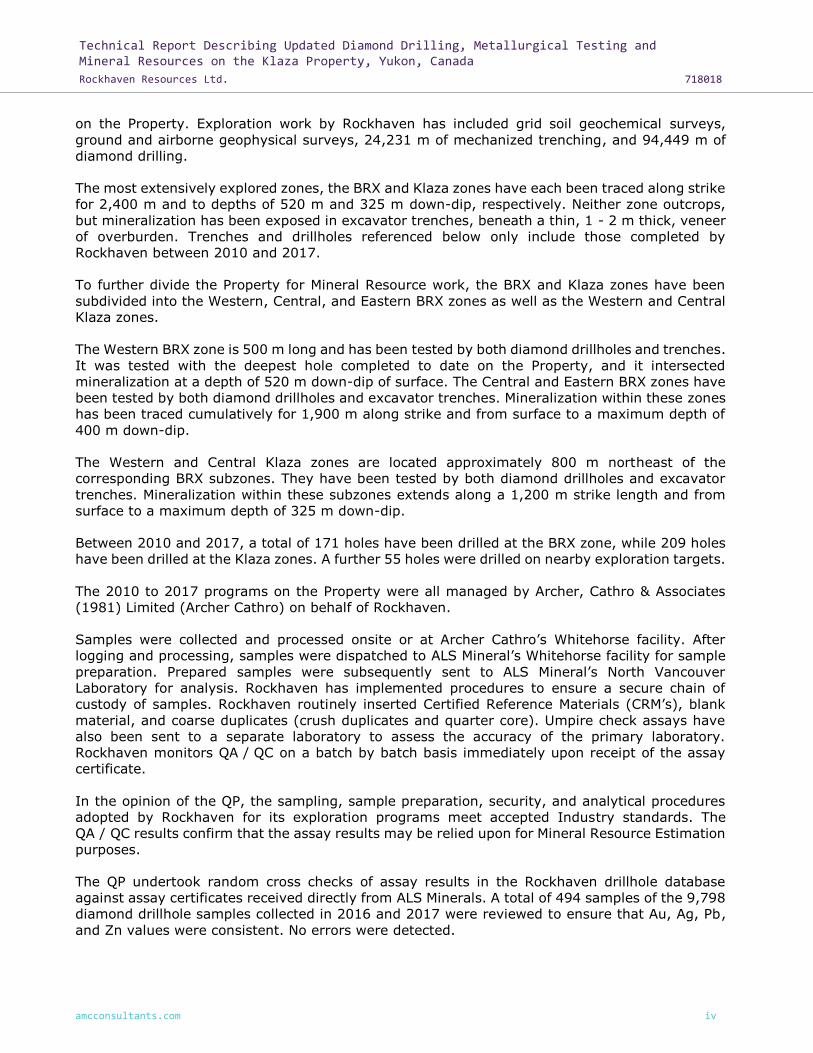
Technical Report Describing Updated Diamond Drilling, Metallurgical Testing and Mineral Resources on the Klaza Property, Yukon, Canada
Rockhaven Resources Ltd. 718018
amcconsultants.com iv
on the Property. Exploration work by Rockhaven has included grid soil geochemical surveys,
ground and airborne geophysical surveys, 24,231 m of mechanized trenching, and 94,449 m of
diamond drilling.
The most extensively explored zones, the BRX and Klaza zones have each been traced along strike
for 2,400 m and to depths of 520 m and 325 m down-dip, respectively. Neither zone outcrops,
but mineralization has been exposed in excavator trenches, beneath a thin, 1 - 2 m thick, veneer
of overburden. Trenches and drillholes referenced below only include those completed by
Rockhaven between 2010 and 2017.
To further divide the Property for Mineral Resource work, the BRX and Klaza zones have been
subdivided into the Western, Central, and Eastern BRX zones as well as the Western and Central
Klaza zones.
The Western BRX zone is 500 m long and has been tested by both diamond drillholes and trenches.
It was tested with the deepest hole completed to date on the Property, and it intersected
mineralization at a depth of 520 m down-dip of surface. The Central and Eastern BRX zones have
been tested by both diamond drillholes and excavator trenches. Mineralization within these zones
has been traced cumulatively for 1,900 m along strike and from surface to a maximum depth of
400 m down-dip.
The Western and Central Klaza zones are located approximately 800 m northeast of the
corresponding BRX subzones. They have been tested by both diamond drillholes and excavator
trenches. Mineralization within these subzones extends along a 1,200 m strike length and from
surface to a maximum depth of 325 m down-dip.
Between 2010 and 2017, a total of 171 holes have been drilled at the BRX zone, while 209 holes
have been drilled at the Klaza zones. A further 55 holes were drilled on nearby exploration targets.
The 2010 to 2017 programs on the Property were all managed by Archer, Cathro & Associates
(1981) Limited (Archer Cathro) on behalf of Rockhaven.
Samples were collected and processed onsite or at Archer Cathro’s Whitehorse facility. After
logging and processing, samples were dispatched to ALS Mineral’s Whitehorse facility for sample
preparation. Prepared samples were subsequently sent to ALS Mineral’s North Vancouver
Laboratory for analysis. Rockhaven has implemented procedures to ensure a secure chain of
custody of samples. Rockhaven routinely inserted Certified Reference Materials (CRM’s), blank
material, and coarse duplicates (crush duplicates and quarter core). Umpire check assays have
also been sent to a separate laboratory to assess the accuracy of the primary laboratory.
Rockhaven monitors QA / QC on a batch by batch basis immediately upon receipt of the assay
certificate.
In the opinion of the QP, the sampling, sample preparation, security, and analytical procedures
adopted by Rockhaven for its exploration programs meet accepted Industry standards. The
QA / QC results confirm that the assay results may be relied upon for Mineral Resource Estimation
purposes.
The QP undertook random cross checks of assay results in the Rockhaven drillhole database
against assay certificates received directly from ALS Minerals. A total of 494 samples of the 9,798
diamond drillhole samples collected in 2016 and 2017 were reviewed to ensure that Au, Ag, Pb,
and Zn values were consistent. No errors were detected.

Technical Report Describing Updated Diamond Drilling, Metallurgical Testing and Mineral Resources on the Klaza Property, Yukon, Canada
Rockhaven Resources Ltd. 718018
amcconsultants.com v
The QP considers the database fit-for-purpose and suitable for use in the estimation of Mineral
Resources.
1.4 Mineral processing and metallurgical testing
Metallurgical testing has consisted of a basic flotation and leaching scoping program on four
composites at SGS in 2014, and a more in depth program which has been conducted at Blue Coast
Research from 2015 to 2018 investigating a number of zones from within the Property. The
majority of testing has focused on samples from the Eastern and Western BRX and the Central
and Western Klaza zones.
Mineralogical examination of several samples showed that quartz, feldspar, and muscovite
dominate the samples representing 75% to 85% of the mineral mass. Sulphides present include
pyrite, arsenopyrite, sphalerite and galena, with minor chalcopyrite in Eastern BRX. Carbonates
are not abundant and there was no evidence of the presence of preg-robbing carbonaceous
material. Gold occurs both as discrete grains and solid solution in both arsenopyrite and pyrite.
Outside of Eastern BRX, the distribution of gold project-wide is approximately 55% refractory
(solid solution) gold contained in arsenopyrite, 8% within pyrite, and 37% discrete gold. Gold in
Eastern BRX occurs more as discrete, leachable grains.
Comminution test work showed the material to have moderate resistance to grinding either by
Semi-Autogenous Grinding (SAG) or ball milling. The Bond Ball Work Index is 16.4 kWh/t and
Bond Rod Work Index is 15.3 kWh/t.
Flotation test work focused on developing a flowsheet consisting of sequential lead, zinc, and
arsenopyrite flotation with the aim of creating saleable lead and zinc concentrates and a gold
bearing arsenopyrite concentrate that could either be economically processed on site or sold. The
final flowsheet features a primary grind of 80% passing 70 microns and standard flotation
reagents. Flotation performance from stable locked-cycle testing on a project-wide composite is
shown in the following table.
Table 1.1 Metallurgical performance from locked cycle testing of project-wide composite
Product Weight Grade
g % Pb (%) Zn (%) Fe (%) Ag (g/t) Au (g/t) As (%) S (%)
Lead cleaner 3 Conc. 46 1.1 59.8 3.1 9.3 5,957 129.9 3.6 19.4
Zinc cleaner 2 Conc. 89 2.2 2.0 48.0 9.0 1,318 13.5 1.0 30.7
AsPy Conc. 485 12.1 0.3 1.0 35.0 73 30.7 6.7 33.4
Rougher tail 3,389 84.5 0.04 0.04 2.4 4 0.27 0.05 0.9
Feed 4,009 100 0.8 1.3 6.5 110 5.73 0.9 5.7
Product Weight % distribution
g % Pb Zn Fe Ag Au As S
Lead cleaner 3 Conc. 46 1.1 85 3 2 62 26 4 4
Zinc cleaner 2 Conc. 89 2.2 6 85 3 27 5 2 12
AsPy Conc. 485 12.1 5 10 65 8 65 88 71
Rougher tail 3,389 84.5 4 3 31 3 4 5 13
Feed 4,009 100 100 100 100 100 100 100 100
Source: Blue Coast Metallurgy Ltd.
The lead concentrate is relatively high grade and should be attractive to many smelters, however
arsenic, antimony, and mercury levels may incur penalties, although this should not affect
marketability. High gold grades may also limit the number of smelters which can accept the lead

Technical Report Describing Updated Diamond Drilling, Metallurgical Testing and Mineral Resources on the Klaza Property, Yukon, Canada
Rockhaven Resources Ltd. 718018
amcconsultants.com vi
concentrate. Zinc concentrates are relatively low-grade but are saleable at 48% zinc, though
payment on the precious metals will, at best, be poor.
The base case assumption for the 2016 PEA was that arsenopyrite concentrates will be treated
on-site to produce doré, the marketability of which is not a factor. The base case also includes
intensive leaching of the lead concentrate to extract much of the gold into doré form.
To date pressure oxidation (POX) has been assumed to be the pre-oxidation process of choice for
the refractory gold bearing arsenopyrite concentrate. The extraction of gold by carbon-in-leach
after pressure oxidation was 98%.
Intensive leach testing has been conducted on several samples of lead concentrate. The leach
achieved 80 – 85% gold extraction within four hours. Reagent consumption was low indicating
that the process would likely be economic. Therefore, intensive cyanidation of this concentrate
has been built into the processing flowsheet.
The overall response of the project-wide composite, in terms of key metal recoveries is shown
below. Both lead and zinc recoveries, to their respective concentrates, were 85%. Total silver
recovery was 91% and gold recovery was 6%. Recovery to doré for gold and silver was 85% and
11% respectively, accordingly the sale of doré will account for the vast majority of the revenue
from the operation.
A summary of the metal recovery to doré and concentrates is provided in Table 1.2.
Table 1.2 Summary of metal recovery to doré and concentrates from testwork on the
project-wide composite
Lead Zinc Silver Gold
Pb to lead concentrate 85%
Zn to zinc concentrate 85%
Au to doré 87%
Au to lead concentrate 4%
Au to zinc concentrate 5%
Ag to Doré 11%
Ag to lead concentrate 53%
Ag to zinc concentrate 27%
Total metal recoveries to payables products 85% 85% 91% 96%
Source: Blue Coast Metallurgy Ltd.
Since completion of the PEA study, the application of gravity pre-concentration has been tested
more extensively and for the purposes of the current resource evaluation has been included in
the processing flowsheet. Mean recoveries to pre-concentrate are shown below. Recoveries were
lower when treating lower grade samples.
Table 1.3 Mean recoveries from gravity pre-concentration testing
Mass pull Au recovery Pb recovery Zn recovery
Central Klaza, > 1 g/t Au 45% 96.3% 93.4% 94.9%
Western Klaza, >1 g/t Au 32% 74.3% 85.8% 70.6%
Eastern BRX, > 0.5 g/t Au 46% 94.8% 91.0% 86.3%
Western BRX, > 1 g/t Au 53% 98.0% 93.9% 92.9%
Source: Blue Coast Metallurgy Ltd.

Technical Report Describing Updated Diamond Drilling, Metallurgical Testing and Mineral Resources on the Klaza Property, Yukon, Canada
Rockhaven Resources Ltd. 718018
amcconsultants.com vii
These data have been used in conjunction with the recovery data in Table 1.2 to arrive at overall
metal recovery algorithms accounting for pre-concentration losses and used for resource
estimating as described in this report. It has been assumed that metal recoveries from
pre-concentrate to saleable products would be unchanged from the whole ore1 recoveries
described in Table 1.2.
Flowsheet development for Eastern BRX has followed a different path reflecting the more
free-milling nature of the gold and the much lower base metal contents. A process incorporating
sequential flotation of a gold-rich concentrate and then a bulk sulphide concentrate has been
developed. The gold-rich concentrate responds very well to intensive cyanide leaching, and the
bulk sulphide concentrate to conventional cyanide leaching after regrinding. No POX is needed for
Eastern BRX. Overall gold recoveries are approximately 80%. The flowsheet developed was
developed with view to using equipment needed for the rest of the project. As such additional
equipment needed to treat Eastern BRX is limited to a regrind mill on the sulphide concentrate.
1.5 Mineral Resource estimates
The Mineral Resource estimate was completed using 322 drillholes on the Property comprising
68,948 m of diamond core and 27,266 assays. Grade interpolation was completed predominantly
using Ordinary kriging (OK), except for the Central Klaza zone where grade was interpolated using
a combination of Ordinary kriging (OK), multiple indicator kriging (MIK), local multiple indicator
kriging (LMIK), and restricted ordinary kriging (ROK). Gold, silver, lead, zinc, copper, iron, and
arsenic were estimated. Copper and iron were estimated to provide data for a base metal to rock
density regression analysis to facilitate density modelling. Arsenic was estimated to aid
metallurgical assessment.
Mineralized domains were constructed by Archer Cathro to constrain the continuous higher grade
main structures and veins. Dyke intersections were used as a marker to help constrain the
orientation and position of mineralization. In the previous estimate, high-grade solids were built
to capture only vein mineralization and often consisted of only one or two samples in a drillhole.
In this estimate, the three-dimensional solids were wider and incorporated waste.
For the OK estimation, 25 of Archer Cathro’s mineralization wireframes were used to constrain
the interpolation.
A combination of LMIK and ROK estimation was used to model complex, splay hosted
mineralization delineated by relatively limited drilling in the Central Klaza area. AMC created a
new mineralization envelope for the LMIK model based on a nominal 0.3 g/t AuEQ boundary and
broad geological control. An intermediate MIK model incorporating change of support was used to
produce a selective mining unit (SMU) model for gold and silver. ROK was used to estimate lead,
zinc, copper, iron, and arsenic. The MIK models were converted to simplified, localized versions
of the MIK models (LMIK) to replicate recoverable panel models on the SMU block dimensions,
and then incorporating the ROK modelled elements as required.
AMC’s review of Rockhaven’s 2,644 density data measurements demonstrates strong linear
relationship between rock density and the sum of Cu, Pb, Zn, and Fe. Densities were assigned to
the block model based on a linear regression formula incorporating the sum of these elements.
The pit-constrained Mineral Resources are reported for blocks occuring 3 m below the topographic
surface to account for weathering, and above a conceptual pit shell based on a US$1,400/ounce
1 The word “ore” has been used in metallurgical and processing descriptions because of its common industry usage in this context. The word “ore” is not meant to imply that Mineral Reserves have been estimated.

Technical Report Describing Updated Diamond Drilling, Metallurgical Testing and Mineral Resources on the Klaza Property, Yukon, Canada
Rockhaven Resources Ltd. 718018
amcconsultants.com viii
gold price. The cut-off applied for reporting the open pit Mineral Resources is 1.0 g/t gold
equivalency (AuEq, defined in Table 1.4).
The underground Mineral Resources are reported outside of the conceptual pit shells. No
allowances have been made for crown pillars. The cut-off applied to the underground Mineral
Resources is 2.30 g/t AuEq. Assumptions made to derive a cut-off grade included mining costs,
processing costs and recoveries and were obtained from this report and comparable industry
situations.
Table 1.4 Gold equivalent (AuEq) formula
Zone Au Recovery %
AuEQ (g/t) Au Ag Pb Zn
Central Klaza >1.0 g/t 92 86 79 81 AUEQ = 1 x AU + AG/94.40 + PB/3.38 + ZN/3.21
<1.0 g/t 78 76 73 71 AUEQ = 1 x AU + AG/90.56 + PB/3.10 + ZN/3.11
Western Klaza All 96 91 85 85 AUEQ = 1 x AU + AG/93.09 + PB/3.28 + ZN/3.20
Western BRX & Central BRX
>1.0 g/t 94 87 80 79 AUEQ = 1 x AU + AG/95.34 + PB/3.41 + ZN/3.37
<1.0 g/t 64 57 49 42 AUEQ = 1 x AU + AG/99.08 + PB/3.79 + ZN/4.31
Note: AuEQ values assume metal prices of US$1,400/oz Au, US$19/oz Ag, US$1.10/lb Pb, and US$1.25/lb Zn, and payable values of 97% Au, 81% Ag, 62% Pb, and 56% Pb. Source: AMC Mining Consultants (Canada) Ltd.
The Mineral Resource for the Klaza deposit has been estimated by Dr A. Ross. P.Geo. Principal
Geologist of AMC, who takes responsibility for the portions of the model estimated by OK and Mr
Ingvar Kirchner, Principal Geologist of AMC Mining Consultants Pty Ltd (Perth, Australia) who takes
responsibility for the portions of the model estimated by MIK, LMIK, and ROK.
AMC is not aware of any known environmental, permitting, legal, title, taxation, socioeconomic,
marketing, political, or other similar factors that could materially affect the stated Mineral
Resource estimate.
Mineral Resources that are not Mineral Reserves do not have demonstrated economic viability.
The summary results of the estimate are shown in Table 1.5 below.

Technical Report Describing Updated Diamond Drilling, Metallurgical Testing and Mineral Resources on the Klaza Property, Yukon, Canada
Rockhaven Resources Ltd. 718018
amcconsultants.com ix
Table 1.5 Summary of Mineral Resources as of 5 June 2018
Resource classification
Tonnes (Kt)
Grade Contained metal
Au Ag Pb Zn AuEQ Au Ag Pb Zn Au EQ
(g/t) (g/t) (%) (%) (g/t) (Koz) (Koz) (Klbs) (Klbs) (Koz)
Indicated
Pit constrained 2,447 5.3 90 0.7 1.0 6.7 414 7,096 39,143 52,935 529
Underground 2,010 4.2 108 0.8 0.9 5.8 272 6,974 34,125 39,172 378
Indicated total 4,457 4.8 98 0.7 0.9 6.3 686 14,071 73,268 92,107 907
Inferred
Pit constrained 1,754 2.6 43 0.4 0.5 3.3 147 2,429 14,897 18,599 187
Underground 3,960 2.8 90 0.7 0.8 4.2 359 11,472 62,647 70,578 538
Inferred total 5,714 2.8 76 0.6 0.7 3.9 507 13,901 77,544 89,176 725
Notes: CIM definition (2014) standards were used for the Mineral Resource. Estimate includes drill results to 31 December 2017. Near surface mineral resources are constrained by an optimized pit shell at metal prices of $1,400/oz Au, $19/oz Ag, $1.10/lb Pb and $1.25/lb Zn. Cut-off grades applied to the pit-constrained and underground resources are 1.0 g/t AuEQ and 2.3 g/t AuEQ respectively. Gold equivalent values were calculated using parameters outlined in Table 14.4. Numbers may not add due to rounding. All metal prices are quoted in US$ at an exchange rate of US$0.80 to C$1.00.
Mineral resources that are not mineral reserves do not have demonstrated economic viability. Source: AMC Mining Consultants (Canada) Ltd.
1.6 Mineral Reserve estimates
There are no Mineral Reserve estimates to report for the Property.
1.7 Mining methods
Mineral Resources occur as a selection of vein systems contained in two distinct zones – Klaza
and BRX. Each zone can be further broken down by relative location: Western, Central and
Eastern. At Central Klaza potential exists in the eastern extremity for underground mining. The
eastern extent is naturally separated from the Central zone by low grade mineralization. The
eastern extent of the Central zone would be accessed by an independent decline system and for
mining purposes is termed Eastern Klaza. The Eastern BRX zone is only considered as upside
potential that warrants further study.
The Klaza and BRX zones lend themselves to open pit mining as the mineralized veins are located
close to surface. The surrounding topography is moderately steep with sufficient flat areas suitable
for the placement of waste dumps and stockpiles. The open pit is planned to be mined using
conventional drill-and-blast and utilizing truck and excavator mining equipment by contractor.
Recommendations for the pit slope design are based on probabilistic kinematic analyses. The
bench height was limited to 10 m. The berm width of 6.0 m is considered to be sufficient to ensure
retention of bench-scale size failures.
Mineralization has been identified through exploration drilling below the potential open pits to a
depth of approximately 450 m below surface, both zones remain open at depth and along strike.
Both the Klaza and BRX zones are amenable to mining by underground methods. The proposed
underground mining method is Longhole stoping with waste rock fill. Underground mining is
planned to be owner-operator with the equipment owned, and personnel employed by Rockhaven.

Technical Report Describing Updated Diamond Drilling, Metallurgical Testing and Mineral Resources on the Klaza Property, Yukon, Canada
Rockhaven Resources Ltd. 718018
amcconsultants.com x
In order to determine an appropriate production rate that can be supported by the deposit, AMC
has used a combination of Taylor`s rule of thumb and vertical tonnes per metre to determine
expected production ranges. AMC recommends that the BRX deposit and Klaza deposit be mined
as two virtually independent operations at a combined production rate of 550 kilotonnes per
annum (ktpa). This production rate is well supported by the detailed production scheduling.
The Klaza and BRX veins are approximately parallel and 800 m apart. Separate declines were
designed for Klaza, Eastern Klaza and BRX. Access to the Klaza zone underground mine is via
three 5 m by 5 m declines and crosscuts on each level. Levels are spaced at a vertical distance of
30 m floor to floor. Development (4 m by 4 m) was designed to follow the vein along strike from
a central access crosscut. The Western and Central Klaza decline commences from the portal on
surface and splits into two declines to access the Western and Central zones. The Eastern Klaza
stopes are accessed by an independent decline from surface. Main access to the BRX zone has a
similar design, with two declines and crosscuts as necessary. Decline access is designed with a
1:7 gradient.
In general, the rock quality values typically range from Poor to Good. Based on a floor to back
height of 30 m, at a 65° dip, stope lengths of 18 m for unsupported walls and 44 m for supported
walls will be stable. Dilution for Longhole stopes has been estimated using the equivalent linear
overbreak slough (ELOS) technique and was estimated by AMC to be less than 0.5 m from the
hangingwall.
For both zones, the mine will be ventilated by a “Pull” or exhausting type ventilation system. That
is, the primary mine ventilation fans will be located at the primary exhaust airways of the mine.
Fresh air will enter each mine via the decline portals with exhaust to the surface via a dedicated
return airway. During the winter, air will be heated by direct propane gas fired heaters at the
portal, with the heat ducted to the intake airflow. Based upon the equipment required, a total of
approximately 290 m³/s is planned for ventilation of both the Klaza and BRX underground mines.
Tetra Tech EBA Inc. (Tetra Tech EBA) was retained by Rockhaven to install a groundwater
monitoring well network in the area of the identified resource and to conduct a preliminary
hydrogeological assessment for the area of the mineralized zones at Klaza. A preliminary
monitoring well network consisting of five nested monitoring wells was installed; four additional
observations wells were fitted with vibrating wire piezometers (VWPs) to monitor pore pressures
at different depths in each of the observation wells. Permafrost appears to act as a confining
layer for the deeper bedrock aquifer. The groundwater flow regime at the site is controlled by the
steep terrain with groundwater flow from areas at higher elevations on the mountain slopes
toward the valley bottoms.
Based on Tetra Tech EBA's observations, AMC has assumed a low ground-water inflow that can
be sufficiently pumped from the mine workings using submersible pumps and a six inch discharge
pipeline. The majority of the discharge water will be service water for operating equipment.
During development the decline will be equipped with power for distribution underground as well
as a four inch pipeline for mine service water and a six inch pipeline for dewatering.
Telecommunications will be provided by a conventional leaky feeder system.
On all levels, the planned main escape route is either the main decline or to the return air raise
(RAR). RAR’s will be equipped with ladder ways for personnel egress. Refuge stations will be
placed strategically in the underground mine, they will be portable for flexibility of location.
Typical equipment for a mechanized Longhole stoping underground mine were selected by AMC.
Development will be undertaken using 2 boom Jumbo development drills, stope drilling will be

Technical Report Describing Updated Diamond Drilling, Metallurgical Testing and Mineral Resources on the Klaza Property, Yukon, Canada
Rockhaven Resources Ltd. 718018
amcconsultants.com xi
undertaken using production drill rigs. Bolters and cablebolters will undertake all ground support
installation. Forty tonne articulated trucks will be used to haul mineralized material from the
underground mines to surface. Suitable quantities of auxiliary equipment such as a water truck,
grader, scissor lifts, personnel transporters, and utility vehicles were also estimated by AMC.
In order to optimize the overall value of the project and the sequence of mining each zone, AMC
has determined potential revenue for each pit and each underground zone. The zones were then
ranked in order of value. The potential revenue from each source provides a basis for the order
in which the pits and underground zones are scheduled. In addition, there is a focus to have the
open pits mined early in the mine life in order to enable placement of process tailings in the
depleted pits.
The proposed combined life-of-mine (LOM) production schedule for the open pit and
underground is summarized in Table 1.6.
Table 1.6 Combined OP and UG LOM production schedule
Production YR0 YR1 YR2 YR3 YR4 YR5 YR6 YR7
Waste (kt) 4,433 4,398 4,128 4,048 1,176 165 155 45
Mineralization (kt) 144 337 596 664 552 391 551 550
AuEQ (g/t) 3.3 4.8 4.1 4.7 6.2 4.5 5.1 5.1
UG production YR8 YR9 YR10 YR11 YR12 YR13 YR14 Total
Waste (kt) 8 104 23 1 18,686
Mineralization (kt) 549 510 524 470 310 204 93 6,444
AuEQ (g/t) 4.6 3.7 3.4 3.5 3.3 2.9 2.9 4.4
Source: AMC Mining Consultants (Canada) Ltd.
Proposed production from the open pit and underground is stockpiled in YR0, during the
construction of the process plant. It was assumed that the process plant will be capable of reaching
85% capacity (470 ktpa) during YR1 and 100% capacity in YR2. The process plant has been
designed for a maximum throughput of 1,650 tpd. The proposed processing schedule is
summarized in Table 1.7.

Technical Report Describing Updated Diamond Drilling, Metallurgical Testing and Mineral Resources on the Klaza Property, Yukon, Canada
Rockhaven Resources Ltd. 718018
amcconsultants.com xii
Table 1.7 Processing schedule
Total production YR0 YR1 YR2 YR3 YR4 YR5 YR6 YR7
Mill feed (kt) 470 550 550 550 550 550 550
Aueq (g/t) 4.3 4.3 5.2 6.2 3.7 5.2 5.1
Au (g/t) 3.7 3.6 4.3 4.8 2.9 4.0 3.7
Ag (g/t) 49 49 72 100 57 95 102
Pb (%) 0.6 0.8 0.7 1.0 0.6 0.6 0.7
Zn (%) 1.1 1.0 1.0 1.0 0.7 0.7 0.8
As (%) 0.5 0.5 0.6 0.6 0.4 0.5 0.5
Total production YR8 YR9 YR10 YR11 YR12 YR13 YR14 Total
Mill feed (kt) 550 523 524 470 310 204 93 6,444
Aueq (g/t) 4.7 3.8 3.4 3.5 3.3 2.9 2.9 4.4
Au (g/t) 3.4 2.5 2.2 2.3 2.6 2.2 2.5 3.3
Ag (g/t) 95 95 82 86 44 50 24 77
Pb (%) 0.6 0.7 0.8 0.9 0.6 0.3 0.2 0.7
Zn (%) 0.8 0.8 0.9 0.8 0.5 0.6 0.7 0.8
As (%) 0.6 0.4 0.4 0.4 0.3 0.3 0.1 0.5
Source: AMC Mining Consultants (Canada) Ltd.
1.8 Recovery methods
Gravity pre-concentration, on run-of-mine materials from Western, Central and Eastern BRX will
reduce the tonnage feeding the grinding and flotation circuits by approximately 50%. The
pre-concentrate, a mix of gravity heavies and screened fines, will be fed to the grinding circuit.
Western Klaza material, which responds poorly to pre-concentration, would be fed as whole ore
to the primary mill after crushing.
Pre-concentration tails, comprising the other 50% of the run of mine tonnage, would be
co-disposed in the tailings facility with the mill tails.
Processing of the pre-concentrate mirrors that described for whole ore in the 2016 PEA, except
for the possible option of direct sale of the sulphide concentrate. After primary grinding, sequential
rougher and cleaner flotation would produce a gold-rich lead concentrate and a zinc product. The
lead concentrate would undergo intensive leaching to extract most of the gold prior to being
shipped to market. The gold extracted through this leach would be upgraded to doré. The zinc
product is poorer in gold and would be shipped directly.
The zinc circuit tails would be subjected to flotation of the gold-bearing sulphides. These would
be a blend of pyrite and arsenopyrite, the precise mix of which would depend on whether the
concentrate was to be processed on-site using pressure hydrometallurgy or sold to a third party.
Mill tailings, a mix of flotation tails and hydrometallurgical residues, would be stored in the tailings
facility.

Technical Report Describing Updated Diamond Drilling, Metallurgical Testing and Mineral Resources on the Klaza Property, Yukon, Canada
Rockhaven Resources Ltd. 718018
amcconsultants.com xiii
1.9 Tailing Storage Facility
The tailings management strategy focusses on the protection of the regional groundwater and
surface waters both during operations and in the long-term (after closure), and to achieve
effective reclamation at mine closure. The tailings management strategy has been developed to
manage the different tailings streams in separate facilities based on the tailings geochemical
properties. Two tailings streams will be produced:
• Hydromet residue tailings.
• Flotation tailings.
The hydromet tailings will be managed in a separate facility sized to contain the production
schedule volume. The flotation tailings will be managed using a surface facility with a containment
structure until approximately Year 6, when the open pits will be available to receive tailings. The
tailings facility designs minimize the project footprint, prevent surface effluent discharge during
operations, and allow for simple and effective water management at closure.
A preliminary site water balance has indicated a net water input requirement to provide sufficient
process water. It is proposed additional water to support operations will come from the Klaza
River. The aim of the water management plan will be to utilize water within the project area to
the maximum practical extent. The plan involves collecting and managing site runoff from
disturbed areas and maximizing the recycle of process water. Excess water will be stored in the
supernatant pond within the Flotation Tailings Facility and recycled to the mill for use during
processing.
1.10 Project infrastructure
A trade-off study was performed to investigate providing electric power using diesel generators
or using grid power from the territorial utility. The results indicate that grid electrical power
provides more value to the project over the life of the mine. The grid power option would require
a transmission power line to be constructed from Carmacks to the mine-site along the existing
Mount Nansen and placer access roads.
The water treatment plant will be located at the processing plant operation. Underground mine
water from operations, surface water from the open pits, and grey water from the office and mine
dry will be routed via dual wall heat traced HDPE piping systems, partially or completely buried,
to the plant for processing as part of the tailings system.
Potable water will also be provided by a treatment plant and will be capable of providing 60 gallons
per day per man to the offices and mine dry.
A network of light vehicle roads will be provided to keep personnel vehicles separate from the
open pit and underground mine haul traffic. These roads will be constructed in accordance with
applicable permafrost design requirements.
The mine offices will be an assembly of standard construction industry grade, portable trailers.
The trailer complex will provide for a perimeter of offices, a common area in the centre, meeting
rooms, lunch rooms, and training rooms. The mine dry will also be an assembly of construction
industry grade, portable trailers. Space for 200 lockers and baskets will be provided along with
showers and laundry facilities. The underground mines will be supported by a centrally located
maintenance facility near the offices, a heated warehouse, and a cold storage warehouse.
Labour will be sourced from the local area around Klaza. The workforce will be encouraged to live
in Carmacks and a daily bus service will be provided to drive the workforce 73 km to the mine

Technical Report Describing Updated Diamond Drilling, Metallurgical Testing and Mineral Resources on the Klaza Property, Yukon, Canada
Rockhaven Resources Ltd. 718018
amcconsultants.com xiv
and back. The total mining labour and supervision requirements were estimated to be
180 employees; this excludes contractor labour for the open pit. A further 75 employees are
required for processing with a total workforce of 255 employees. There is no allowance for a mine
camp.
Mine water will be supplied via a four-inch steel line down the declines that will be installed as the
decline progresses. At required levels, pressure reducing and isolation valves will be installed to
maintain the system at operating pressures. A two-inch distribution system of steel pipe and hoses
will be laid out on the operating levels and relocated as required during the mine life.
The mine dewatering system will consist of staged 50 horsepower (HP) submersible dirty water
pumps at 60 m levels. Each sump will have two pumps to provide continual redundancy. A six-inch
steel line will remove the water from the mines and direct it to the process water treatment facility.
Underground telecommunications will be provided by a conventional leaky feeder system strung
down the decline and feeding the operating levels.
Compressed air will be supplied by mobile electric compressors. These will be situated on active
levels and at the maintenance bay. The compressors will be relocated to active mining levels as
needed.
The main part of the explosives will be stored on surface as part of the open pit mine operations.
The underground mines will continue to use the open pit facilities as the project completes the
open pit phase of the work.
Fuel storage will consist of two tanks that will have the capacity to support two months
consumption at peak production. The tank system will be enclosed by a lined berm of sufficient
capacity to contain 110% of the contents of a full tank in the event of a major leak or spillage.
Fuel will be trucked to site on a year round basis.
Portable refuge stations in the operating levels as well as lunchrooms near the maintenance area
will be provided. Facilities for self-rescue storage in the lunchrooms as well as first aid kits at the
refuge stations will also be in place.
Main egress is provided by the declines, and a second means of egress via the ladders in the
ventilation raises.
1.11 Market studies and contracts
Initial metallurgical tests showed elevated levels of penalty elements in the forecast lead and zinc
concentrates. In addition, the low levels of zinc in zinc concentrates and the high levels of gold in
lead concentrates were seen to be potentially difficult in the marketing of both concentrates.
Although this is a PEA based on Inferred Mineral Resources, Rockhaven decided to undertake an
additional degree of research regarding the marketability of the concentrates. The high percentage
of precious metals reporting to the lead concentrate was determined to potentially impact
marketability and lead to inclusion of the Acacia leach process. In addition, a concerted effort was
made to reduce the potential deleterious elements present in the concentrates and, thereby,
improve the marketability.
While H. M. Hamilton & Associates Inc. (HMH) has investigated possible markets and potential
terms, no detailed market study has been undertaken at this stage of the project.

Technical Report Describing Updated Diamond Drilling, Metallurgical Testing and Mineral Resources on the Klaza Property, Yukon, Canada
Rockhaven Resources Ltd. 718018
amcconsultants.com xv
1.12 Environmental studies and permitting
A preliminary environmental assessment was undertaken for the Klaza property that addressed
the following considerations:
• Reviewed and summarized existing relevant social and environmental data, including
government data sets.
• Developed a list of key regulatory approvals required and an outline of the Yukon regulatory
approval process.
• Identified principal areas of concern / key issues related to permitting and the environment.
• Described site specific environmental and land-use issues (parks, land use conflicts, specific
flora, fauna issues, Species at Risk, other potentially significant constraints).
• Provided a general outline of the sequence, timeline and cost estimates to advance the
project through the permitting / approvals stage (up to approval to construct).
• Developed recommendations on how to proceed and types of studies that may be required
to support the regulatory review and approvals process.
Based on the information reviewed as part of this preliminary environmental assessment, there
were no known significant environmental issues or sensitive receptors / features identified that
could materially influence project viability, nor affect the major design components for future mine
development.
The level of information contained in the existing environmental and social data reviewed as part
of the PEA is considered sufficient to facilitate the scoping of a comprehensive environmental
baseline study in order to meet future assessment and approval requirements. Any future baseline
studies would require targeted biophysical and socio-economic considerations be identified and
assessed. Once the initial stages of mine planning have been completed and conceptual level
detail is determined, it will be possible to identify and define a baseline assessment program.
1.13 Capital and operating costs
The operating cost estimate allows for all labour, equipment, consumables, supervision, and
technical services. Operating costs for underground mining are based on AMC’s database of
underground mine costs. AMC has then validated the benchmark costs against a number of
Canadian mining operations located either in the Yukon or North-West Territory. Actual costs for
an operating mine near Klaza were also used to validate the assumptions.
The process operating cost estimate was provided by Blue Coast Metallurgy Ltd. (BCM). The
process operating costs are separated out in two components. Firstly, the mineral processing
sections of the mill: grinding, milling, flotation concentrate filtration and load-out. Secondly, for
the hydromet sections, which include POX, hot cure, CCD’s, neutralization, cyanide leach – CIP,
and gold recovery to doré.
Process operating costs were determined from both first principles make-up and vendor quotes
from other recent projects. These include all labour and supervision, consumables, reagents and
power. Vendor quoted delivered costs were obtained for the major consumables: power, flotation
reagents, lime, limestone, cyanide, and oxygen. Maintenance costs were determined from similar
projects and industry standards.
G&A costs generally cover site administration and corporate costs. AMC benchmarked its estimate
of $12/t against knowledge of the G&A cost ($13/t) for a similar operation in northern Canada.
The total operating cost is summarized in Table 1.8.

Technical Report Describing Updated Diamond Drilling, Metallurgical Testing and Mineral Resources on the Klaza Property, Yukon, Canada
Rockhaven Resources Ltd. 718018
amcconsultants.com xvi
Table 1.8 Total operating cost
Description Cost (C$/t) Cost (C$M)
Mining cost 59.7 384
Processing cost 43.4 279
General and Administration cost 12.0 77
Total operating cost 115.1 741
Note: Totals may not add up exactly due to rounding. Source: AMC Mining Consultants (Canada) Ltd.
The capital cost estimate is split into project capital (first four years) and sustaining capital
(remainder of the mine life). No royalties apply to the project. Project capital includes the cost of
the process plant, underground equipment and infrastructure, underground development, and
surface infrastructure.
AMC has assumed that, due to the short life of the pits (five years), a contractor will be used to
mine the open pits. Mark-ups on the operating costs have been assumed to cover for the capital
costs and no capital has been allowed for the open pits.
The process plant capital cost estimate was provided by BCM. AMC estimated the capital cost for
the underground mines and surface infrastructure.
The major components of the surface infrastructure cost estimate are refurbishment of existing
access roads and new site roads, mine office, mine dry, and maintenance workshop.
The underground capital cost comprises primarily of underground development (lateral and
vertical), underground mobile equipment and underground infrastructure. Capital costs for
equipment are based on supplier quotes for other recent projects. Equipment numbers were
estimated to meet the production target of 550 ktpa. Underground infrastructure costs are based
on estimated quantities, some supplier quotes from other recent projects or from benchmark
construction costs and assumptions. The underground infrastructure largely consists of electrical
distribution, ventilation, and dewatering costs.
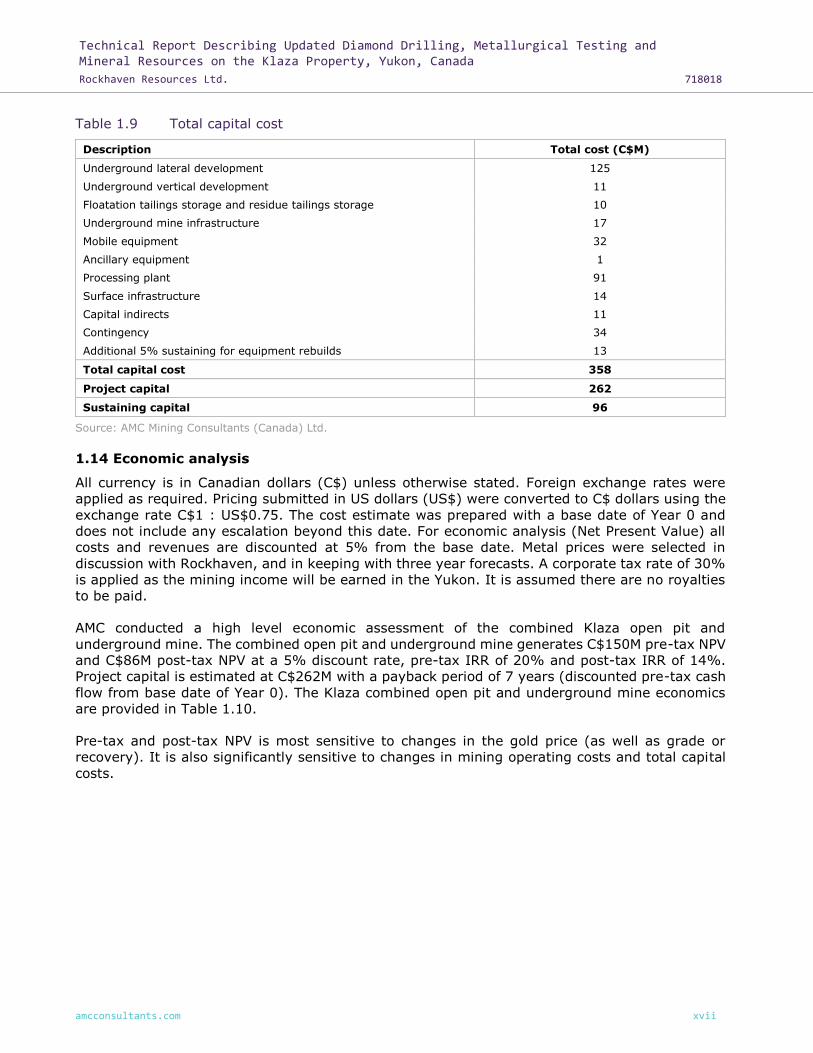
The total capital cost is estimated to be C$358M and is summarized in Table 1.9.
Technical Report Describing Updated Diamond Drilling, Metallurgical Testing and Mineral Resources on the Klaza Property, Yukon, Canada
Rockhaven Resources Ltd. 718018
amcconsultants.com xvii
Table 1.9 Total capital cost
Description Total cost (C$M)
Underground lateral development 125
Underground vertical development 11
Floatation tailings storage and residue tailings storage 10
Underground mine infrastructure 17
Mobile equipment 32
Ancillary equipment 1
Processing plant 91
Surface infrastructure 14
Capital indirects 11
Contingency 34
Additional 5% sustaining for equipment rebuilds 13
Total capital cost 358
Project capital 262
Sustaining capital 96
Source: AMC Mining Consultants (Canada) Ltd.
1.14 Economic analysis
All currency is in Canadian dollars (C$) unless otherwise stated. Foreign exchange rates were
applied as required. Pricing submitted in US dollars (US$) were converted to C$ dollars using the
exchange rate C$1 : US$0.75. The cost estimate was prepared with a base date of Year 0 and
does not include any escalation beyond this date. For economic analysis (Net Present Value) all
costs and revenues are discounted at 5% from the base date. Metal prices were selected in
discussion with Rockhaven, and in keeping with three year forecasts. A corporate tax rate of 30%
is applied as the mining income will be earned in the Yukon. It is assumed there are no royalties
to be paid.
AMC conducted a high level economic assessment of the combined Klaza open pit and
underground mine. The combined open pit and underground mine generates C$150M pre-tax NPV
and C$86M post-tax NPV at a 5% discount rate, pre-tax IRR of 20% and post-tax IRR of 14%.
Project capital is estimated at C$262M with a payback period of 7 years (discounted pre-tax cash
flow from base date of Year 0). The Klaza combined open pit and underground mine economics
are provided in Table 1.10.
Pre-tax and post-tax NPV is most sensitive to changes in the gold price (as well as grade or
recovery). It is also significantly sensitive to changes in mining operating costs and total capital
costs.

Technical Report Describing Updated Diamond Drilling, Metallurgical Testing and Mineral Resources on the Klaza Property, Yukon, Canada
Rockhaven Resources Ltd. 718018
amcconsultants.com xviii
Table 1.10 Klaza combined open pit and underground mine economics
Klaza Unit Value
Total mineralized rock kt 6,444
Total waste production kt 18,686
Gold grade g/t 3.3
Silver grade g/t 77
Lead grade % 0.7
Zinc grade % 0.8
Gold price US$/oz 1,200
Silver price US$/oz 16.00
Lead price US$/lb 0.80
Zinc price US$/lb 0.85
Payable gold metal kg 19,606
Payable silver metal kg 353,457
Payable lead metal t 23,233
Payable zinc metal t 23,792
Revenue by commodity (gold) % 74
Revenue by commodity (silver) % 18
Revenue by commodity (lead) % 4
Revenue by commodity (zinc) % 4
Total net revenue C$M 1,365
Capital costs C$M 357
Operating costs (total) C$M 741
Mine operating costs C$/t mineralized rock 59.7
Process and tails storage operating costs C$/t mineralized rock 43.4
Operating costs (total) C$/t mineralized rock 115
Operating cash cost (AuEQ) US$/oz AuEQ 651.5
Total all in sustaining cost (AuEQ) US$/oz AuEQ 965.9
Payback period Yrs 7
Cumulative cash flows (pre-tax) C$M 266
Pre-tax NPV 1 C$M 150
Pre-tax IRR % 20
Post-tax NPV 1 C$M 86
Post-tax IRR % 14
Note: 1 Discount rate of 5%. Source: AMC Mining Consultants (Canada) Ltd.
1.15 Interpretations and conclusions
The results of the PEA suggest that the Project has good economic potential and warrants further
study.
Standard industry practices, equipment and processes were used in this study. The authors of
this report are not aware of any unusual or significant risks, or uncertainties that could
materially affect the reliability or confidence in the project based on the data and information
made available.
The Mineral Resource used for the PEA was entirely classified as an Inferred Mineral Resource.

Technical Report Describing Updated Diamond Drilling, Metallurgical Testing and Mineral Resources on the Klaza Property, Yukon, Canada
Rockhaven Resources Ltd. 718018
amcconsultants.com xix
The typical risks associated with open pit and underground mining related to geotechnical
conditions, equipment availability and productivity, and personnel productivity are generally
similar to those expected at other remote operations.
The PEA is preliminary in nature. It includes Inferred Mineral Resources that are considered too
speculative geologically to have the economic considerations applied to them that would enable
them to be categorized as Mineral Reserves. There is no certainty that the PEA will be realized.
1.16 Recommendations
1.16.1 Geology and Mineral Resources
Work at the Klaza Property has defined significant, high-grade gold-silver-lead-zinc Mineral
Resources. AMC recommends the following:
• Conduct further drilling of the BRX East and other Eastern Zones in order to sufficiently
increase the drillhole density to enable completion of a Mineral Resource estimate.
• Collect samples from previously unsampled drill core intervals within the Eastern Zones in
order to complete the sample record.
• Conduct exploration diamond drilling beneath and along strike of prospective targets
identified by trenching and diamond drilling.
• Update the Mineral Resource estimate on completion of the drill program and additional
sampling within the Eastern Zones.
• Initiate an updated PEA utilizing the updated Mineral Resource and metallurgy.
• Going forward, take duplicate samples only from mineralized material.
1.16.2 Hydrology
The following Tetra Tech EBA recommendations are made for further hydrogeological assessment
at Klaza:
• Continue seasonal groundwater monitoring for the existing monitoring and observation
wells.
• Survey all monitoring wells for their location and elevation of the top of the PVC casing with
an accuracy of about ±1 cm or better.
• Collect additional ground temperature and hydrogeological data from the existing
observation and monitoring wells, and drill additional wells as required. This data will allow
updates to the preliminary conceptual hydrogeological model with an emphasis on
permafrost-groundwater interaction.
• As mine planning progresses, install additional monitoring wells in the areas up and down
gradient of proposed mine infrastructure.
• Intergrate groundwater and surface water baseline data collection and interpret both
datasets to assess groundwater-surface water interaction.
1.16.3 Geotechnical
Obtain a better understanding of the factors affecting open pit and stope stability and the proposed
mining method from additional data collection, interpretation, and analysis, including the
following:
• Developing a series of 3D models that includes lithology, alteration and major structure.
• Using data from these models develop a 3D geotechnical model.
• Continue collecting geotechnical information during infill and exploration drilling. Preferably
orient core whenever possible to increase confidence and understanding of structures.

Technical Report Describing Updated Diamond Drilling, Metallurgical Testing and Mineral Resources on the Klaza Property, Yukon, Canada
Rockhaven Resources Ltd. 718018
amcconsultants.com xx
• Implement a laboratory testing program on the various lithologies to assist in understanding
rock properties. The following suite of rock property tests is recommended: Uniaxial
compressive strength (UCS) with Young’s modulus (E) and Poisson’s ratio (v), Confined
compressive strength (triaxial), Indirect tensile strength (Brazilian test).
• As the mine is likely to be developed to depth > 300 m below ground level, in-situ stress
testing will likely be needed. This could be carried out once mining has commenced.
1.16.4 Mining and infrastructure
AMC recommends the following work to be undertaken during the next phase of study:
• Re-evaluate open pit and underground mining opportunities for any updates to the Mineral
Resource estimate.
• Reassess open pit-underground interface and specifics of crown pillar requirements.
• Further investigate underground stope sizing and confirm mining method.
• Further investigate the open pit mining method and bench height to evaluate means of
reducing dilution.
• Develop development and production schedules.
• Project groundwater inflow to the proposed pits and underground mines from updated
hydrogeological modelling.
• Should the hydrogeological modelling and study of the ground water regime indicate
potential for large quantities of inflow into the mine, investigate a non-contact dewatering
system. Water captured prior to entering the mining floor can reduce the cost of water
treatment later.
• Undertake cost estimation and obtain contractor quotes for operating costs.
• Increase the level of detail for infrastructure engineering to better define capital costs.
• Undertake further work to support the assumptions that:
⎯ Mine workforce would be based in Carmacks and bused to and from site on a daily
basis.
⎯ Sufficient local grid power is available.
1.16.5 Processing and metallurgical testwork
BCM recommends the following for the Klaza project, ahead of preparation of a revised PEA study:
• Eastern BRX process development: For the flotation-leach process developed using whole
ore material, demonstrate its application to EBRX pre-concentrate together with a projection
of metallurgical recoveries.
• Pre-concentration: Conduct sufficient testing to establish PEA level metallurgical projections
and process design for the use of pre-concentration on all zones except Western Klaza.
• Refractory gold concentrate development: Continue testing aimed at maximizing the gold
grade / recovery relationship for arsenopyrite-hosted refractory gold.
• Conduct a marketing study on the refractory gold concentrate.
1.16.6 Tailings Storage Facility
• Evaluate additional tailings storage potential within the Klaza open pits KL1 and 2 by
constructing containment dams across the low point of the pit and increasing storage
capacity.
• Complete rheology testing and geotechnical testing of the tailings streams.

Technical Report Describing Updated Diamond Drilling, Metallurgical Testing and Mineral Resources on the Klaza Property, Yukon, Canada
Rockhaven Resources Ltd. 718018
amcconsultants.com xxi
• Complete geotechnical investigations to evaluate foundation conditions and construction
material sources.
• Complete geotechnical investigations at the Klaza KL1 and 2 open pits to determine
suitability for tailings storage.
1.16.7 Environmental
Continue ongoing collection and evaluation of baseline data.
1.16.8 Proposed budget for recommendations
An approximate budget for the recommended work described above is presented in Table 26.1.
Table 1.11 Proposed budget for recommendations
Parameter Cost (C$000’s)
Eastern Zone infill drilling (6,000 m @ $220/m) 1,320
Exploration drilling (6,000 m @ $220/m) 1,320
Hydrological monitoring 50
Geotechnical testwork, modelling, and interpretation 50
Metallurgical studies 60
Marketing study 20
Updated Resource and PEA 400
Environmental baseline studies to stage ready for EA 600
Contingency @ 15% 573
Total (excluding taxes) 4,393
Source: Archer, Cathro & Associates (1981) Limited.

Technical Report Describing Updated Diamond Drilling, Metallurgical Testing and Mineral Resources on the Klaza Property, Yukon, Canada
Rockhaven Resources Ltd. 718018
amcconsultants.com xxii
Contents
1 Summary .............................................................................................................. ii 1.1 Geology and mineralization .............................................................................. ii 1.2 History ......................................................................................................... iii 1.3 Exploration and drilling ................................................................................... iii 1.4 Mineral processing and metallurgical testing...................................................... v 1.5 Mineral Resource estimates ............................................................................ vii 1.6 Mineral Reserve estimates .............................................................................. ix 1.7 Mining methods ............................................................................................. ix 1.8 Recovery methods ........................................................................................ xii 1.9 Tailing Storage Facility ................................................................................. xiii 1.10 Project infrastructure ................................................................................... xiii 1.11 Market studies and contracts ......................................................................... xiv 1.12 Environmental studies and permitting ............................................................. xv 1.13 Capital and operating costs ............................................................................ xv 1.14 Economic analysis ....................................................................................... xvii 1.15 Interpretations and conclusions .................................................................... xviii 1.16 Recommendations ....................................................................................... xix
1.16.1 Geology and Mineral Resources...................................................... xix 1.16.2 Hydrology ................................................................................... xix 1.16.3 Geotechnical ............................................................................... xix 1.16.4 Mining and infrastructure ............................................................... xx 1.16.5 Processing and metallurgical testwork ............................................. xx 1.16.6 Tailings Storage Facility ................................................................. xx 1.16.7 Environmental ............................................................................. xxi 1.16.8 Proposed budget for recommendations ........................................... xxi
2 Introduction ......................................................................................................... 33
3 Reliance on other experts ...................................................................................... 36
4 Property description and location ............................................................................ 37
5 Accessibility, climate, local resources, infrastructure, and physiography ...................... 47
6 History ................................................................................................................ 50
7 Geological setting and mineralization ...................................................................... 60 7.1 Regional geology .......................................................................................... 60 7.2 Property geology .......................................................................................... 64 7.3 Mineralization ............................................................................................... 66
7.3.1 Mineralization – Work Area 2 .......................................................... 68 7.3.2 Mineralization – other work areas ................................................... 71
8 Deposit types ....................................................................................................... 72 8.1 Mineralization style on the Property ................................................................ 72 8.2 Characteristics of carbonate base metal gold deposits ....................................... 72
9 Exploration .......................................................................................................... 74 9.1 Geological mapping ....................................................................................... 74 9.2 Soil geochemical surveys ............................................................................... 74 9.3 Excavator trenching ...................................................................................... 81 9.4 Geophysical surveys ...................................................................................... 83
10 Drilling ................................................................................................................ 89 10.1 Diamond drilling summary ............................................................................. 89 10.2 Diamond drilling specifications........................................................................ 97

Technical Report Describing Updated Diamond Drilling, Metallurgical Testing and Mineral Resources on the Klaza Property, Yukon, Canada
Rockhaven Resources Ltd. 718018
amcconsultants.com xxiii
10.3 Drill collar and down-hole surveys................................................................... 97 10.4 Oriented core surveys ................................................................................... 98
11 Sample preparation, analyses, and security ............................................................. 99 11.1 Introduction ................................................................................................. 99 11.2 Sampling methods ........................................................................................ 99
11.2.1 Soil sampling methods ................................................................... 99 11.2.2 Rock and trench sampling methods ................................................. 99 11.2.3 Diamond drill core sampling methods ............................................ 100
11.3 Sample shipment and security ...................................................................... 101 11.4 Sample preparation and analysis .................................................................. 102 11.5 Quality Assurance and Quality Control ........................................................... 102
11.5.1 Assay results of Certified Reference Materials ................................. 103 11.5.2 Assay results of blank samples ..................................................... 106 11.5.3 Assay results of duplicates ........................................................... 106 11.5.4 Results of external check assays ................................................... 110
11.6 Data validation ........................................................................................... 111 11.6.1 Database verification ................................................................... 111 11.6.2 Collar location verification ............................................................ 111 11.6.3 Down-hole orientation verification ................................................. 112 11.6.4 Assay verification ........................................................................ 112
11.7 Conclusions ................................................................................................ 112
12 Data verification ................................................................................................. 113
13 Mineral processing and metallurgical testing .......................................................... 115 13.1 Process development for Eastern BRX ........................................................... 116
13.1.1 Flotation testing .......................................................................... 116 13.2 Cyanide leaching ........................................................................................ 116 13.3 Pre-concentration testing ............................................................................. 117 13.4 Flotation testing on the pre-concentrate ........................................................ 118 13.5 Flotation to create a potentially saleable refractory gold concentrate ................. 118
14 Mineral Resource estimates .................................................................................. 120 14.1 Introduction ............................................................................................... 120
14.1.1 Drillhole database ....................................................................... 121 14.1.2 Bulk density ............................................................................... 122
14.2 Ordinary kriging domaining and estimation parameters ................................... 123 14.2.1 Domain modelling OK .................................................................. 123 14.2.2 Statistics and compositing OK ....................................................... 125 14.2.3 Block model OK .......................................................................... 129
14.2.3.1 Block model parameters ............................................... 129 14.2.3.2 Variography and grade estimation .................................. 129
14.2.4 Mineral Resource classification OK ................................................. 130 14.2.5 Block model validation OK ............................................................ 131
14.3 MIK / LMIK / ROK domaining and estimation parameters ............................... 131 14.3.1 Domain modelling MIK / LMIK / ROK ............................................. 131 14.3.2 Statistics and compositing MIK / LMIK / ROK .................................. 132 14.3.3 Block model MIK / LMIK / ROK ..................................................... 135
14.3.3.1 Block model parameters MIK / LMIK / ROK ...................... 135 14.3.3.2 Estimation methods MIK / LMIK / ROK ............................ 136 14.3.3.3 Variography and grade estimation MIK / LMIK / ROK ........ 138
14.3.4 Mineral Resource classification MIK / LMIK / ROK ............................ 141 14.3.5 Block model validation MIK / LMIK / ROK ....................................... 141
14.4 Mineral Resource estimate ........................................................................... 141

Technical Report Describing Updated Diamond Drilling, Metallurgical Testing and Mineral Resources on the Klaza Property, Yukon, Canada
Rockhaven Resources Ltd. 718018
amcconsultants.com xxiv
14.5 Comparison with previous Mineral Resource estimate ...................................... 146
15 Mineral Reserve estimates ................................................................................... 149
16 Mining methods .................................................................................................. 150 16.1 Hydrological parameters .............................................................................. 150 16.2 Geotechnical parameters ............................................................................. 151
16.2.1 Local lithology ............................................................................ 152 16.2.2 Rock Quality Designation (RQD) .................................................... 153 16.2.3 Rock mass characterization .......................................................... 153 16.2.4 Open pit geotechnical considerations ............................................. 155
16.2.4.1 Open pit slope design ................................................... 155 16.2.4.2 Empirical analysis ........................................................ 156 16.2.4.3 Limit equilibrium analysis .............................................. 157 16.2.4.4 Kinematic analysis ....................................................... 157
16.2.5 Pit wall design parameters ........................................................... 158 16.2.6 Underground geotechnical considerations ....................................... 159
16.2.6.1 Stable stope spans ....................................................... 159 16.2.6.2 Stope dilution estimation .............................................. 161 16.2.6.3 Preliminary ground support estimates ............................. 162
16.3 Mineral Resource model for mining ............................................................... 164 16.3.1 Gold equivalent .......................................................................... 164
16.4 Cut-off value .............................................................................................. 164 16.5 Open pit .................................................................................................... 166
16.5.1 Dilution and mining recovery factors ............................................. 166 16.5.2 Mining method ............................................................................ 167
16.5.2.1 Stockpile rehandling ..................................................... 167 16.5.2.2 Ancillary equipment ...................................................... 168
16.5.3 Pit design and selection ............................................................... 168 16.5.3.1 Klaza ultimate pit selection ............................................ 168 16.5.3.2 Western BRX ultimate pit selection ................................. 170 16.5.3.3 Pit design .................................................................... 171
16.5.4 Layout of other open pit mining related facilities ............................. 176 16.5.5 Open pit equipment ..................................................................... 176 16.5.6 Open pit labour and supervision .................................................... 177
16.6 Open pit to underground interface ................................................................ 178 16.7 Underground mining ................................................................................... 179
16.7.1 Underground mining method ........................................................ 179 16.7.2 Dilution and mining recovery factors ............................................. 180 16.7.3 Production rate analysis ............................................................... 181 16.7.4 Stope design and selection ........................................................... 181 16.7.5 Underground development ........................................................... 182 16.7.6 Proposed infrastructure ................................................................ 184 16.7.7 Ventilation ................................................................................. 184 16.7.8 Secondary egress........................................................................ 185 16.7.9 Underground equipment .............................................................. 186 16.7.10 Underground labour and supervision ............................................. 186
16.8 Projected life-of-mine development and production schedule ............................ 188 16.8.1 Mine sequence optimization .......................................................... 188 16.8.2 Conceptual open pit production schedule ....................................... 188 16.8.3 Projected underground development schedule ................................ 189 16.8.4 Conceptual underground production schedule ................................. 190 16.8.5 Waste rockfill ............................................................................. 192 16.8.6 Conceptual combined production schedule ..................................... 193

Technical Report Describing Updated Diamond Drilling, Metallurgical Testing and Mineral Resources on the Klaza Property, Yukon, Canada
Rockhaven Resources Ltd. 718018
amcconsultants.com xxv
16.8.7 Projected process plant feed schedule ........................................... 194
17 Recovery methods .............................................................................................. 196 17.1 Process Flow Sheet ..................................................................................... 196 17.2 Tailings management .................................................................................. 197
17.2.1 General ..................................................................................... 197 17.2.2 Hydromet Residue Storage Facility ................................................ 199 17.2.3 Flotation Tailings Facility .............................................................. 199 17.2.4 Open pit flotation tailings disposal ................................................. 200 17.2.5 Water management ..................................................................... 201
18 Project infrastructure .......................................................................................... 203 18.1 Surface infrastructure.................................................................................. 203
18.1.1 Mine offices ................................................................................ 203 18.1.2 Mine dry .................................................................................... 203 18.1.3 Sewage treatment....................................................................... 203 18.1.4 Garbage incineration ................................................................... 203 18.1.5 Power ........................................................................................ 203
18.1.5.1 Generation .................................................................. 203 18.1.5.2 Distribution ................................................................. 204
18.1.6 Water supply .............................................................................. 204 18.1.7 Maintenance shop and warehousing .............................................. 205 18.1.8 Surface mobile equipment ............................................................ 205 18.1.9 Accommodations ......................................................................... 205 18.1.10 Fire detection and suppression systems ......................................... 205 18.1.11 Roads ........................................................................................ 206 18.1.12 Waste water ............................................................................... 206 18.1.13 Explosives .................................................................................. 207 18.1.14 Open pit .................................................................................... 207
18.2 Underground infrastructure .......................................................................... 207 18.2.1 Lunchrooms ............................................................................... 207 18.2.2 Workshop .................................................................................. 208 18.2.3 Fuel and lube bay ....................................................................... 208 18.2.4 Explosives magazine ................................................................... 208 18.2.5 Compressed air........................................................................... 208 18.2.6 Service water ............................................................................. 208 18.2.7 Communications ......................................................................... 208 18.2.8 Dewatering ................................................................................ 208 18.2.9 Mine escape and rescue ............................................................... 209
18.3 Logistics .................................................................................................... 209 18.4 Personnel movement ................................................................................... 209 18.5 Inbound freight .......................................................................................... 209 18.6 Outbound concentrate ................................................................................. 209 18.7 Fuel storage ............................................................................................... 209 18.8 Tailings disposal ......................................................................................... 209 18.9 Stockpiles .................................................................................................. 210
19 Market studies and contracts................................................................................ 211 19.1 Metal prices ............................................................................................... 211 19.2 Product grades and volumes ........................................................................ 211 19.3 Marketing .................................................................................................. 211
19.3.1 Overview ................................................................................... 211 19.3.2 Lead concentrate treatment terms ................................................ 212 19.3.3 Zinc concentrate treatment terms ................................................. 212

Technical Report Describing Updated Diamond Drilling, Metallurgical Testing and Mineral Resources on the Klaza Property, Yukon, Canada
Rockhaven Resources Ltd. 718018
amcconsultants.com xxvi
19.3.4 Transportation ............................................................................ 212 19.3.4.1 Overview .................................................................... 212 19.3.4.2 Total transportation costs .............................................. 213
19.3.5 Net smelter / mine returns – summary .......................................... 213
20 Environmental studies, permitting, and social or community impact .......................... 214 20.1 Summary of available environmental and socio-economic information ............... 214
20.1.1 Government databases ................................................................ 214 20.1.2 Existing environmental studies and data ........................................ 214 20.1.3 Discussion on available environmental information .......................... 216
20.1.3.1 Terrain and access ....................................................... 217 20.1.3.2 Hydrogeology .............................................................. 217 20.1.3.3 Fisheries and aquatic resources ..................................... 218 20.1.3.4 Wildlife and species at risk ............................................ 218 20.1.3.5 Land use, mineral tenure, and protected areas ................ 219 20.1.3.6 Heritage impact assessment .......................................... 219 20.1.3.7 Available information summary ...................................... 219
20.1.4 Identified (to date) environmental concerns ................................... 220 20.2 Approvals and permitting ............................................................................. 220
20.2.1 Yukon Environmental and Socio-Economic Assessment Board
(YESAB) ..................................................................................... 220 20.2.2 Existing approvals and permits ..................................................... 221
20.2.2.1 Current exploration activities ......................................... 221 20.2.2.2 Quartz mining license ................................................... 221 20.2.2.3 Water license ............................................................... 221
20.3 First Nation consultation .............................................................................. 222 20.3.1 Little Salmon Carmacks First Nation .............................................. 222 20.3.2 Selkirk First Nation ...................................................................... 222
20.4 Closure and remediation .............................................................................. 222 20.4.1 Environmental liabilities ............................................................... 222 20.4.2 Reclamation and closure planning ................................................. 223
21 Capital and operating costs .................................................................................. 224 21.1 Operating cost estimate ............................................................................... 224
21.1.1 Open pit .................................................................................... 224 21.1.2 Underground mine ...................................................................... 225 21.1.3 Processing ................................................................................. 226 21.1.4 Tailings storage .......................................................................... 229 21.1.5 General and administration (G&A) ................................................. 229
21.2 Total operating cost .................................................................................... 229 21.2.1 Open pit .................................................................................... 229 21.2.2 Underground mine ...................................................................... 229
21.2.2.1 Underground development ............................................ 230 21.2.2.2 Underground mobile equipment ..................................... 230 21.2.2.3 Underground infrastructure ........................................... 230
21.2.3 Process plant .............................................................................. 231 21.2.4 Surface infrastructure .................................................................. 232 21.2.5 Closure costs .............................................................................. 233 21.2.6 Sustaining capital ........................................................................ 233 21.2.7 Indirect capital ........................................................................... 233 21.2.8 Contingency ............................................................................... 233 21.2.9 Total capital cost estimate ............................................................ 233
22 Economic analysis ............................................................................................... 235

Technical Report Describing Updated Diamond Drilling, Metallurgical Testing and Mineral Resources on the Klaza Property, Yukon, Canada
Rockhaven Resources Ltd. 718018
amcconsultants.com xxvii
22.1 Assumptions .............................................................................................. 235 22.2 Economic analysis ....................................................................................... 235 22.3 Sensitivity analysis ..................................................................................... 239
23 Adjacent properties ............................................................................................. 242
24 Other relevant data and information ..................................................................... 243
25 Interpretation and conclusions ............................................................................. 244 25.1 Summary .................................................................................................. 244 25.2 Risk and opportunity management ................................................................ 244
26 Recommendations .............................................................................................. 249 26.1 Geology and Mineral Resources .................................................................... 249 26.2 Hydrology .................................................................................................. 249 26.3 Geotechnical .............................................................................................. 249 26.4 Mining and infrastructure ............................................................................. 250 26.5 Processing and metallurgical testwork ........................................................... 250 26.6 Tailings Storage Facility ............................................................................... 250 26.7 Environmental ............................................................................................ 250 26.8 Proposed budget for recommendations .......................................................... 250
27 References ......................................................................................................... 252
28 QP certificates .................................................................................................... 261
Tables
Table 1.1 Metallurgical performance from locked cycle testing of project-wide composite .. v
Table 1.2 Summary of metal recovery to doré and concentrates from testwork on the
project-wide composite .............................................................................. vi
Table 1.3 Mean recoveries from gravity pre-concentration testing .................................. vi
Table 1.4 Gold equivalent (AuEq) formula ................................................................. viii
Table 1.5 Summary of Mineral Resources as of 5 June 2018 .......................................... ix
Table 1.6 Combined OP and UG LOM production schedule ............................................. xi
Table 1.7 Processing schedule .................................................................................. xii
Table 1.8 Total operating cost ................................................................................. xvi
Table 1.9 Total capital cost .................................................................................... xvii
Table 1.10 Klaza combined open pit and underground mine economics ......................... xviii
Table 1.11 Proposed budget for recommendations ....................................................... xxi
Table 2.1 Persons who prepared or contributed to this technical report .......................... 34
Table 4.1 Claim data ............................................................................................... 37
Table 4.2 Work Area claims ...................................................................................... 45
Table 6.1 Work Area 1 exploration history.................................................................. 51
Table 6.2 Work Area 2 exploration history.................................................................. 52
Table 6.3 Work Area 3 exploration history.................................................................. 56
Table 6.4 Work Area 4 exploration history.................................................................. 56
Table 6.5 Work Area 5 exploration history.................................................................. 57
Table 6.6 Work Area 6 exploration history.................................................................. 58
Table 7.1 Regional lithologies ................................................................................... 62
Table 8.1 CBM comparison with BRX and Klaza zones .................................................. 73

Technical Report Describing Updated Diamond Drilling, Metallurgical Testing and Mineral Resources on the Klaza Property, Yukon, Canada
Rockhaven Resources Ltd. 718018
amcconsultants.com xxviii
Table 9.1 Geochemical data for soil samples from Work Area 2..................................... 74
Table 9.2 2010 to 2017 Excavator trenching summary ................................................ 81
Table 10.1 2010 to 2017 diamond drilling summary ...................................................... 89
Table 10.2 Data for main mineralized zones ................................................................. 91
Table 10.3 Downhole survey correction factor .............................................................. 98
Table 11.1 QA / QC samples by year ......................................................................... 103
Table 11.2 Recommended values of Certified Reference Materials ................................. 104
Table 11.3 2016 – 2017 Assay results of CRMs for gold ............................................... 105
Table 12.1 Inspected drillholes ................................................................................. 113
Table 13.1 Mean recoveries from pre-concentration of samples .................................... 117
Table 14.1 Resource by area and estimation method .................................................. 120
Table 14.2 Summary of Mineral Resources as of 5 June 2018 ....................................... 120
Table 14.3 Summary of Mineral Resources as of 5 June 2018 ....................................... 121
Table 14.4 Gold Equivalent (AuEQ) formula ............................................................... 121
Table 14.5 Drillhole data used in the Mineral Resource estimate ................................... 122
Table 14.6 Domain nomenclature ............................................................................. 123
Table 14.7 Top cutting ranges by element ................................................................. 125
Table 14.8 Statistics of raw, capped, and composite assay data – Western BRX ............. 126
Table 14.9 Statistics of raw, capped, and composite assay data – Central BRX ............... 127
Table 14.10 Statistics of raw, capped, and composite assay data – Western Klaza ............ 128
Table 14.11 Statistics of raw, capped, and composite assay data – Central Klaza ............. 129
Table 14.12 Block model parameters .......................................................................... 129
Table 14.13 Pass 1 search ellipse parameters .............................................................. 130
Table 14.14 DOMAIN flags used for the Central Klaza LMIK model .................................. 131
Table 14.15 Statistics of raw, capped, and composite assay data – Central Klaza (DOMAIN 71)
............................................................................................................ 134
Table 14.16 Indicator thresholds and intra-class grades and probabilities used for the MIK
estimates ............................................................................................... 135
Table 14.17 Block model parameters .......................................................................... 136
Table 14.18 Variogram model parameters ................................................................... 139
Table 14.19 Search neighbourhood parameters used for estimation of the Central Klaza splay
mineralization domain ............................................................................. 140
Table 14.20 Conceptual pit shell parameters applied to all zones .................................... 142
Table 14.21 Conceptual pit shell parameters applied to specific zones ............................. 142
Table 14.22 Mineral Resources as of 5 June 2018 (Western BRX) ................................... 143
Table 14.23 Mineral Resources as of 5 June 2018 (Central BRX) ..................................... 143
Table 14.24 Mineral Resources as of 5 June 2018 (Western Klaza) ................................. 143
Table 14.25 Mineral Resources as of 5 June 2018 (Central Klaza) ................................... 144
Table 14.26 Klaza and BRX deposits pit-constrained Indicated Mineral Resource estimate (all
zones) cut-off grade sensitivity ................................................................. 144
Table 14.27 Klaza and BRX deposits pit-constrained Inferred Mineral Resource estimate (all
zones) cut-off grade sensitivity ................................................................. 145
Table 14.28 Klaza and BRX deposits underground Indicated Mineral Resource estimate (all
zones) cut-off grade sensitivity ................................................................. 146

Technical Report Describing Updated Diamond Drilling, Metallurgical Testing and Mineral Resources on the Klaza Property, Yukon, Canada
Rockhaven Resources Ltd. 718018
amcconsultants.com xxix
Table 14.29 Klaza and BRX deposits underground Inferred Mineral Resource estimate (all
zones) cut-off grade sensitivity ................................................................. 146
Table 14.30 Comparison of AMC 2015 and 2018 pit-constrained Mineral Resource estimation
............................................................................................................ 147
Table 14.31 Comparison of AMC 2015 and 2018 underground Mineral Resource estimation
............................................................................................................ 148
Table 16.1 Total drillhole length within lithological units .............................................. 153
Table 16.2 RQD values and descriptions (Deere, 1964) ............................................... 153
Table 16.3 Typical FOS and POF acceptance criteria values (Read & Stacey, 2009) ......... 156
Table 16.4 MRMR and slope height by geotechnical domain ......................................... 156
Table 16.5 Summary of open pit slope angles based on empirical analyses .................... 156
Table 16.6 Probabilistic kinematic assessment results for open pit (BRX) ....................... 158
Table 16.7 Probabilistic kinematic assessment results for open pit (Klaza) ..................... 158
Table 16.8 Open pit design parameters for BRX .......................................................... 159
Table 16.9 Open pit design parameters for Klaza ........................................................ 159
Table 16.10 Recommended ground support for Mineralized rock, GRD, and QFP rocks ...... 164
Table 16.11 Recommended ground support for GRD and QFP rocks (Intersections) .......... 164
Table 16.12 Recommended ground support for Fault zones ........................................... 164
Table 16.13 NSR cut-off value assumptions ................................................................. 166
Table 16.14 Open pit mining dilution and recovery ....................................................... 167
Table 16.15 Open pit drilling parameters ..................................................................... 167
Table 16.16 Open pit projected tonnes and grades ....................................................... 175
Table 16.17 Equipment selection ................................................................................ 177
Table 16.18 Open pit contractor workforce .................................................................. 178
Table 16.19 Underground Inferred Mineral Resource ..................................................... 181
Table 16.20 Development physicals ............................................................................ 182
Table 16.21 Key underground design parameters ......................................................... 182
Table 16.22 Equipment selection ................................................................................ 186
Table 16.23 Combined open pit and underground technical services ............................... 187
Table 16.24 Underground labour and supervision ......................................................... 187
Table 16.25 Ranking of zone value ............................................................................. 188
Table 16.26 Conceptual open pit production schedule ................................................... 189
Table 16.27 Proposed underground development schedule ............................................ 190
Table 16.28 Projected underground production schedule ............................................... 191
Table 16.29 Projected annual underground waste rock fill schedule ................................ 192
Table 16.30 Conceptual LOM production schedule......................................................... 193
Table 16.31 Projected process plant feed schedule ....................................................... 194
Table 19.1 Projected lead concentrate terms .............................................................. 212
Table 19.2 Projected zinc concentrate terms .............................................................. 212
Table 19.3 Projected NSR values for concentrates ...................................................... 213
Table 20.1 Summary of existing environmental studies and data .................................. 215
Table 21.1 Summary of estimated open pit operating cost ........................................... 225
Table 21.2 Summary of estimated underground operating cost .................................... 226

Technical Report Describing Updated Diamond Drilling, Metallurgical Testing and Mineral Resources on the Klaza Property, Yukon, Canada
Rockhaven Resources Ltd. 718018
amcconsultants.com xxx
Table 21.3 Summary of estimated mill operating cost ................................................. 226
Table 21.4 Estimated mill operating costs – fixed and POX driven ................................. 227
Table 21.5 Process operating cost estimate ................................................................ 228
Table 21.6 Tailings storage facility operating cost ....................................................... 229
Table 21.7 Total operating cost estimate ................................................................... 229
Table 21.8 Underground development cost estimate ................................................... 230
Table 21.9 Underground mobile equipment cost estimate ............................................ 230
Table 21.10 Underground infrastructure cost estimate .................................................. 231
Table 21.11 Mill area capital estimate ......................................................................... 232
Table 21.12 Surface infrastructure cost estimate .......................................................... 233
Table 21.13 Total capital cost estimate ....................................................................... 234
Table 21.14 Project and sustaining capital cost estimate ............................................... 234
Table 22.1 Klaza combined open pit and underground mine – key economic assumptions and
results ................................................................................................... 236
Table 22.2 Klaza production and cash flow forecast..................................................... 237
Table 22.3 Klaza economic sensitivity analysis (pre-tax) .............................................. 239
Table 22.4 Klaza economic sensitivity analysis (post-tax) ............................................ 240
Table 25.1 Significant project risks ........................................................................... 246
Table 25.2 Significant project opportunities ............................................................... 248
Table 26.1 Proposed budget for recommendations ...................................................... 251
Figures
Figure 4.1 Property location – Klaza Property .............................................................. 40
Figure 4.2 Claims location – North Western part of Property .......................................... 41
Figure 4.3 Claims location – South Eastern part of Property .......................................... 42
Figure 4.4 Work Area locations .................................................................................. 44
Figure 5.1 Detailed access – Klaza Property ................................................................ 48
Figure 7.1 Regional geology and tectonic setting Klaza Property .................................... 61
Figure 7.2 Property geology – Klaza Property .............................................................. 65
Figure 7.3 Mount Nansen Gold Camp – Klaza Property .................................................. 67
Figure 7.4 Zones and zonation – Klaza Property ........................................................... 69
Figure 9.1 Gold soil geochemical values – Work Area 2 Klaza Property ............................ 76
Figure 9.2 Silver soil geochemical values – Work Area 2 Klaza Property .......................... 77
Figure 9.3 Lead soil geochemical values – Work Area 2 Klaza Property ........................... 78
Figure 9.4 Arsenic soil geochemical values – Work Area 2 Klaza Property ........................ 79
Figure 9.5 Copper soil geochemical values – Work Area 2 Klaza Property ........................ 80
Figure 9.6 Trench locations – Klaza Property ............................................................... 82
Figure 9.7 Airborne magnetics first vertical derivative – Work Area 2 Klaza Property ........ 85
Figure 9.8 VLF-EM data – Work Area 2 Klaza Property .................................................. 86
Figure 9.9 Chargeability – Work Area 2 Klaza Property ................................................. 87
Figure 9.10 Resistivity – Work Area 2 Klaza Property ..................................................... 88
Figure 10.1 Diamond drillhole locations – Klaza Property ................................................ 90
Figure 10.2 Section 9+500 mE Western BRX zone – Klaza Property ................................. 92
Technical Report Describing Updated Diamond Drilling, Metallurgical Testing and Mineral Resources on the Klaza Property, Yukon, Canada
Rockhaven Resources Ltd. 718018
amcconsultants.com xxxi
Figure 10.3 10+600 mE Central BRX zone – Klaza Property ............................................ 94
Figure 10.4 Section 9+500 mE Western Klaza zone – Klaza Property ............................... 95
Figure 10.5 Section 10+050 mE Central Klaza zone – Klaza Property ............................... 96
Figure 11.1 Control chart for 2016 – 2017 KL1 ............................................................ 105
Figure 11.2 Control chart for 2016 – 2017 KL5 ............................................................ 106
Figure 11.3 Relative paired difference plot for coarse reject duplicates ........................... 108
Figure 11.4 Relative paired difference plot for field duplicates ....................................... 109
Figure 11.5 Scatterplot showing ALS Minerals versus SGS analysis in 2015 ..................... 110
Figure 13.1 2017 metallurgical testing sample locations ............................................... 115
Figure 13.2 Eastern BRX proposed process flowsheet ................................................... 117
Figure 13.3 Pre-concentration gold recovery as a function of head grade ........................ 118
Figure 13.4 Selective arsenopyrite flotation from pyrite in processing Western BRX gravity
pre-concentrate ...................................................................................... 119
Figure 14.1 Scatter plot of density versus percentage lead-zinc-copper-iron .................... 122
Figure 14.2 Zone locations with drillholes ................................................................... 124
Figure 14.3 Isometric view of the Western BRX zone looking north east ......................... 124
Figure 14.4 The Central Klaza MIK / LMIK mineralization domain ................................... 132
Figure 14.5 Raw sample interval lengths for Central Klaza (DOMAIN 71) drillhole data ..... 133
Figure 16.1 Drillhole locations and lithological units: Klaza and BRX zones (2010 – 2015) . 152
Figure 16.2 RMR76 by lithological domain .................................................................... 154
Figure 16.3 Q’ by lithological domain .......................................................................... 155
Figure 16.4 Design sectors of open pit for kinematic analysis ........................................ 157
Figure 16.5 Stability graph results for the stope walls: (a) unsupported and (b) supported
(Vein dip-55°) ........................................................................................ 160
Figure 16.6 Recommended spacing and minimum length for cable bolts ......................... 161
Figure 16.7 Stope dilution estimated for the HW .......................................................... 162
Figure 16.8 Depth from 0 to 500 m below surface – Support from Q System (Grimstad and
Barton, 1993) ........................................................................................ 163
Figure 16.9 Optimization results – Klaza ..................................................................... 169
Figure 16.10 Pit optimization sensitivity analysis – discounted at 5% ............................... 170
Figure 16.11 Optimization results – Western BRX .......................................................... 171
Figure 16.12 Klaza pit design ...................................................................................... 172
Figure 16.13 Klaza pit sections showing ADNSR in C$/t .................................................. 173
Figure 16.14 Western BRX pit design ........................................................................... 174
Figure 16.15 Western BRX sections showing ADNSR in C$/t ............................................ 175
Figure 16.16 Layout of open pit infrastructure ............................................................... 176
Figure 16.17 Longhole mining method ......................................................................... 180
Figure 16.18 BRX underground mine design.................................................................. 183
Figure 16.19 Klaza underground mine design ................................................................ 183
Figure 16.20 Proposed BRX ventilation system .............................................................. 185
Figure 16.21 Proposed Klaza ventilation system ............................................................ 185
Figure 16.22 Projected open pit production ................................................................... 189
Figure 16.23 Projected underground development ......................................................... 190

Technical Report Describing Updated Diamond Drilling, Metallurgical Testing and Mineral Resources on the Klaza Property, Yukon, Canada
Rockhaven Resources Ltd. 718018
amcconsultants.com xxxii
Figure 16.24 Projected underground production ............................................................ 191
Figure 16.25 Projected underground waste rock fill requirements .................................... 192
Figure 16.26 Conceptual LOM production schedule and AuEQ grade ................................. 193
Figure 16.27 Projected open pit and underground mine design ........................................ 194
Figure 16.28 Projected process plant feed .................................................................... 195
Figure 17.1 Summarized Klaza Project process flowsheet .............................................. 196
Figure 17.2 Hydromet Residue and Flotation Tailings Facilities overall layout ................... 198
Figure 18.1 Klaza project access road......................................................................... 206
Figure 18.2 General layout of the surface infrastructure for Klaza .................................. 207
Figure 20.1 Water license application process .............................................................. 221
Figure 21.1 Open pit benchmarking costs ................................................................... 224
Figure 21.2 Yukon and NWT underground benchmark mining costs (C$/t) ...................... 225
Figure 22.1 Sensitivity analysis – pre-tax NPV at 5% discount rate ................................ 240
Figure 22.2 Sensitivity analysis – post-tax NPV at 5% discount rate ............................... 241

Technical Report Describing Updated Diamond Drilling, Metallurgical Testing and Mineral Resources on the Klaza Property, Yukon, Canada
Rockhaven Resources Ltd. 718018
amcconsultants.com 33
2 Introduction
AMC Mining Consultants (Canada) Ltd. (AMC) was commissioned by Rockhaven Resources Ltd.
(Rockhaven) to prepare an updated NI 43-101 Technical Report (Technical Report) for the Klaza
property (Property) in Yukon, Canada. This report discloses the results of an updated Mineral
Resource estimate incorporating 2016 and 2017 drilling results, and additional metallurgical studies.
It is an update to those Mineral Resources and metallurgical results reported in a Preliminary
Economic Assessment (PEA) Technical Report prepared by AMC for Rockhaven in February 2016.
The results of the other portions of the 2016 PEA Technical Report described in this Technical Report
are based on the earlier Mineral Resource model, and the studies related to the PEA have not yet
been updated to consider the new Mineral Resource model and the modified metallurgical treatment
scheme.
The Property is located in the southwestern Yukon Territory of Canada approximately
50 kilometres (km) due west of the town of Carmacks. The Property is 100% owned by Rockhaven.
Rockhaven acquired the original Property from ATAC Resources Ltd. in 2009 and subsequently
added more claims through both acquisition and additional staking. Of a total of 1,478 claims, 199
claims are subject to a 1.5% Net Smelter Return (NSR) royalty. Six claims are subject to a 1% NSR
royalty on precious metals and a 0.5% royalty on non-precious metals. The other 1,273 claims,
including the claims over the existing Mineral Resources, are not subject to any underlying royalties.
The Technical Report has focused on the Mineral Resources potentially mineable by open pit and
underground methods for the BRX and Klaza zones.
AMC was responsible for managing and preparing the Technical Report with inputs from Archer,
Cathro & Associates (1981) Limited (Archer Cathro), and Blue Coast Metallurgy Ltd. (BCM).

Technical Report Describing Updated Diamond Drilling, Metallurgical Testing and Mineral Resources on the Klaza Property, Yukon, Canada
Rockhaven Resources Ltd. 718018
amcconsultants.com 34
Table 2.1 Persons who prepared or contributed to this technical report
Qualified Persons responsible for the preparation of this Technical Report
Qualified Person
Position Employer Independent of Rockhaven?
Date of last site visit
Professional designation
Sections of report
Dr A Ross Principal Geologist
AMC Mining Consultants (Canada) Ltd.
Yes 18 – 19 Aug 2015
P.Geo. (BC), P.Geol. (AB)
1 (part), 2, 11 ,12, 14 (part) 25 (part), 26 (part), 27 (part)
Mr I Kirchner Principal Geologist
AMC Mining Consultants Pty Ltd
Yes No visit FAusIMM, MAIG
1 (part) and 14 (part)
Mr C Martin Principal Metallurgist
Blue Coast Metallurgy Ltd.
Yes No visit C.Eng.
1 (part), 13, 17 (part), 19, 25 (part), 26 (part), 27 (part)
Mr M Dumala Senior Engineer and Partner
Archer, Cathro & Associates (1981) Limited
No 14 Oct 2017
P.Eng. (BC) 1 (part), 3 (part), 4-10, 23, 24, 25 (part), 26 (part), 27 (part)
Mr G Methven Principal Mining Engineer
AMC Mining Consultants (Canada) Ltd.
Yes 18 – 19 Aug 2015
P.Eng. (BC)
1 (part), 3 (part), 15, 16 (part), 20, 21 (part), 22, 25 (part), 26 (part), 27 (part)
Mr M Molavi Principal Mining Engineer
AMC Mining Consultants (Canada) Ltd.
Yes No visit P.Eng. (BC) 1 (part), 18, 25 (part), 26 (part)
Mr P Lebleu Principal Mining Engineer
AMC Mining Consultants (Canada) Ltd.
Yes No visit P.Eng. (BC) 1 (part), 16 (part), 21 (part), 25 (part) 26 (part), 27 (part)
Mr B Borntraeger
Engineer Knight Piésold Yes No visit P.Eng. (BC) 1 (part), 17 (part), 26 (part)
Other Experts who assisted the Qualified Persons
Expert Position Employer Independent of Rockhaven?
Visited site Sections of Report
Mr G R Yeadon Secretary & Director
Tupper, Jonsson & Yeadon
No No 4
Ms J Turner
Senior Environmental Planner / Department
Manager
Morrison Hershfield Limited
Yes No 20
Mr S Robinson Senior Geologist
AMC Mining Consultants (Canada) Ltd.
Yes No Overall assistance
Mr A Carne Project Engineer
Archer, Cathro & Associates (1981) Limited
No Ongoing visits Overall assistance
Source: AMC Mining Consultants (Canada) Ltd.
The key information used in this report is listed in Section 27, References.
All currency amounts and commodity prices are in Canadian dollars unless stated otherwise.
Quantities are stated in metric (SI) units. Commodity weights of measure are in grams (g) or
percent (%) unless stated otherwise.
This Technical Report includes the tabulation of numerical data which involves a degree of rounding
for the purpose of Mineral Resource estimation. AMC does not consider any rounding of the
numerical data to be material to the Property.
Technical Report Describing Updated Diamond Drilling, Metallurgical Testing and Mineral Resources on the Klaza Property, Yukon, Canada
Rockhaven Resources Ltd. 718018
amcconsultants.com 35
This Technical Report has been produced in accordance with the Standards of Disclosure for Mineral
Projects as contained in NI 43-101 and accompanying policies and documents. NI 43-101 utilizes
the definitions and categories of Mineral Resources and Mineral Reserves as set out in the May 2014
edition of the Canadian Institute of Mining, Metallurgy and Petroleum (CIM) Definition Standards on
Mineral Resources and Mineral Reserves (CIM Definition Standards).
A draft of the Technical Report was provided to Rockhaven to check for factual accuracy. The
Technical Report is effective as at 5 June 2018.

Technical Report Describing Updated Diamond Drilling, Metallurgical Testing and Mineral Resources on the Klaza Property, Yukon, Canada
Rockhaven Resources Ltd. 718018
amcconsultants.com 36
3 Reliance on other experts
The Qualified Persons have relied, in respect of legal aspects, upon the work of the Expert listed
below. To the extent permitted under NI 43-101, the Qualified Persons disclaim responsibility for
the relevant section of the Technical Report.
The following disclosure is made in respect of this Expert:
Glenn R. Yeadon, Attorney, Tupper, Jonsson & Yeadon, Vancouver, BC, Canada.
Report, opinion or statement relied upon: information on mineral tenure and status, title issues,
royalty obligations, etc. Mr Yeadon is also a director of Rockhaven.
Extent of reliance: full reliance following a review by the Qualified Person(s).
Portion of Technical Report to which disclaimer applies: Section 4.
The Qualified Persons have relied, in respect of environmental aspects, upon the work of the Expert
listed below. To the extent permitted under NI 43-101, the Qualified Persons disclaim responsibility
for the relevant section of the Technical Report.
The following disclosure is made in respect of this Expert:
Jennifer Turner, Senior Environmental Planner, Morrison Hershfield Limited, Burnaby, BC, Canada.
Report, opinion or statement relied upon: information on permitting, environmental, social, and
community factors.
Extent of reliance: full reliance following a review by the Qualified Person(s).
Portion of Technical Report to which disclaimer applies: Section 20.

Technical Report Describing Updated Diamond Drilling, Metallurgical Testing and Mineral Resources on the Klaza Property, Yukon, Canada
Rockhaven Resources Ltd. 718018
amcconsultants.com 37
4 Property description and location
The Property is located in southwestern Yukon at latitude 62°15΄11" north and longitude 137°7΄23"
west on NTS 115I/3 (Figure 4.1). It comprises 1,478 contiguous mineral claims (totalling
approximately 28,620 hectares) registered with the Whitehorse Mining Recorder in the names of
Rockhaven or Archer Cathro, which holds them in trust for Rockhaven.
A total of 199 claims (Dic, Eagle, Etzel, VG, VIC, Jon-Wedge, Rat, Wedge, Ox, Bull, and parts of
J. Bill#) are subject to a 1.5% NSR royalty payable to Janet Dickson of Whitehorse. The six Desk
claims have a 1.0% NSR royalty on precious metals and a 0.5% NSR royalty on non-precious metals
payable to R. Hulstein and R. Stroshein Estate. The other 1,273 claims are not subject to any
underlying royalties. Specifics concerning claim registration are tabulated in Table 4.1, while the
locations of individual claims are shown on Figure 4.2 and Figure 4.3.
Table 4.1 Claim data
Claim name Grant number Expiry date**
BBB
1-96 YD56331-YD56426 15 April 2031
97-152 YD58527-YD58582 15 April 2031
153-172 YD62853-YD62872 15 April 2031
173-255 YD113413-YD113495 15 April 2031
256-384 YE60326-YE60454 15 April 2031
Dic 1-71 YA93470-YA93476 11 January 2041
101-1061 YB35470-YB35475 11 January 2042
Eagle 1-121 YB35415-YB35426 11 January 2042
Etzel
1-121 YA86336-YA86347 1 December 2048
13-171 YA86348-YA86352 1 December 2047
18-201 YA86353-YA86355 1 December 2048
21-281 YA86356-YA86363 1 December 2047
29-321 YA86364-YA86367 1 December 2048
331 YS86368 1 December 2044
341 YA86369 1 December 2048
35-441 YA86370-YA86379 1 December 2048
45-501 YA86380-YA86385 1 December 2047
JCS 1-3 YC25916-YC25918 1 December 2036
Klaza
1-17* YC37984-YC38000 11 January 2044
18-24* YC39051-YC39057 11 January 2044
25-40 YD09205-YD09220 7 January 2044
43-64 YD09223-YD09244 7 January 2044
65F-66F YC99541-YC99542 11 January 2044
68-129 YD07149-YD07210 11 January 2044
133-166 YD07214-YD07247 11 January 2044
167-308 YD119737-YD119878 11 January 2040
309 YD110502 11 January 2040
310-311 YC97706-YC97707 11 January 2041
314-316 YC97722-YC97724 11 January 2041
317-319 YC99801-YC99803 11 January 2035
320-357 YE66241-YE66278 11 January 2032

Technical Report Describing Updated Diamond Drilling, Metallurgical Testing and Mineral Resources on the Klaza Property, Yukon, Canada
Rockhaven Resources Ltd. 718018
amcconsultants.com 38
Claim name Grant number Expiry date**
VG 1-41 YA86406-YA86409 1 December 2045
5-81 YA86410-YA86413 1 December 2037
VIC
21 YA86309 1 December 2047
751 YC19429 1 December 2045
76-781 YC19430-YC19432 1 December 2048
Wedge 11-141 YA82177-YA82180 1 December 2037
Dade
1-16 YD07685-YD07700 23 March 2035
17-54 YD108507-YD108544 23 March 2032
77-90 YD108567-YD108580 23 March 2028
91-96 YC97716-YC97721 23 March 2033
97-106 YD07248-YD07257 23 March 2029
Krast 1-32 YD74101-YD74070 11 January 2028
Queen 1-121 YE60731-YE60851 24 April 2028
Val 1-9 YC25903-YC25911 24 February 2034
10-15* YE85801-YE85806 24 February 2034
Nor 1-74 YE60651-YE60724 24 April 2028
Bull
1-21 YA81420-YA81421 1 December 2044
121 YA86291 29 February 2036
141 YA86293 29 February 2036
16-201 YA86295-YA86299 28 February 2035
21-281 YA86300-YA86307 28 February 2030
D 1-2 YB57373-YB57374 20 January 2030
3-4 YB57375-YB57376 20 January 2038
Desk 1-62 YC47461-YC47466 23 March 2028
J. Bill
1-21 YA78049-YA78050 28 February 2030
3-41 YA78051-YA78052 28 February 2031
5-81 YA78053-YA78056 28 February 2030
9-12 YA78057- YA78060 2 February 2030
131 YA78061 2 February 2038
141 YA78062 2 February 2042
15-161 YA78063-YA78064 2 February 2038
17-241 YA78065-YA78072 02 February 2030
25-28 YA78073-YA78076 28 February 2030
29-301 YA78077-YA78078 28 February 2038
31-321 YA78079-YA78080 28 February 2042
JBF 6 YB36958 1 December 2036
10 YB54543 5 December 2037
Jon-Wedge
11 YB35895 1 December 2038
21 YB35896 1 December 2036
31 YB35897 1 December 2028
41 YB35898 1 December 2029
5-61 YB35899-YB35900 1 December 2028
Ox 1-201 YA86386-YA86405 20 December 2028

Technical Report Describing Updated Diamond Drilling, Metallurgical Testing and Mineral Resources on the Klaza Property, Yukon, Canada
Rockhaven Resources Ltd. 718018
amcconsultants.com 39
Claim name Grant number Expiry date**
Rat
1-81 YA81428-YA81435 28 February 2030
9-241 YA81436-YA81451 28 February 2031
25-401 YA81452-YA81467 28 February 2030
Sked 1-30 YD07655-YA07684 23 March 2030
31-36 YC99722-YC99727 23 March 2028
Lone 1-161 YF59161-YF59321 11 January 2023
Notes: 1 A total of 199 mineral claims (the Dic, the Eagle, the Etzel, the VG, the VIC, the Wedge, the Bull, the Jon-Wedge, the Ox, the Rat and parts of the J. Bill) are subject to a 1.5% NSR royalty payable to Janet Dickson of Whitehorse, Yukon Territory. 2 The six Desk mineral claims are subject to a 1.0% NSR royalty related to precious metals and a 0.5% NSR royalty related to non-precious metals payable to each of Roger Hulstein of Whitehorse, Yukon Territory and the Estate of Robert W. Stroshein. * Includes fractional claims.
**Expiry dates include 2017 work which has been filed for assessment credit but not yet accepted. Source: Archer, Cathro & Associates (1981) Limited.

Technical Report Describing Updated Diamond Drilling, Metallurgical Testing and Mineral Resources on the Klaza Property, Yukon, Canada
Rockhaven Resources Ltd. 718018
amcconsultants.com 40
Figure 4.1 Property location – Klaza Property
Source: Archer, Cathro & Associates (1981) Limited.

Technical Report Describing Updated Diamond Drilling, Metallurgical Testing and Mineral Resources on the Klaza Property, Yukon, Canada
Rockhaven Resources Ltd. 718018
amcconsultants.com 41
Figure 4.2 Claims location – North Western part of Property
Source: Archer, Cathro & Associates (1981) Limited.

Technical Report Describing Updated Diamond Drilling, Metallurgical Testing and Mineral Resources on the Klaza Property, Yukon, Canada
Rockhaven Resources Ltd. 718018
amcconsultants.com 42
Figure 4.3 Claims location – South Eastern part of Property
Source: Archer, Cathro & Associates (1981) Limited.

Technical Report Describing Updated Diamond Drilling, Metallurgical Testing and Mineral Resources on the Klaza Property, Yukon, Canada
Rockhaven Resources Ltd. 718018
amcconsultants.com 43
For the purpose of this report the Property has been subdivided into Work Areas 1 – 6. Historical
exploration programs can cross multiple Work Areas, typically where several claim groups are
closely spaced, or early claims were restaked. Figure 4.4 highlights the boundaries of these Work
Areas, and Table 4.2 describes the claim groups within each Work Area. An area of about 40 km2 is
centred between Work Areas 4 and 6, encompassing the former Mount Nansen mining area, since
declared an abandoned site by the Canadian Federal Government.

Technical Report Describing Updated Diamond Drilling, Metallurgical Testing and Mineral Resources on the Klaza Property, Yukon, Canada
Rockhaven Resources Ltd. 718018
amcconsultants.com 44
Figure 4.4 Work Area locations
Source: Archer, Cathro & Associates (1981) Limited.

Technical Report Describing Updated Diamond Drilling, Metallurgical Testing and Mineral Resources on the Klaza Property, Yukon, Canada
Rockhaven Resources Ltd. 718018
amcconsultants.com 45
Table 4.2 Work Area claims
Work Area Claim groups Area (km2)
1 BBB 78.5
2 Dic, Eagle, Etzel, JCS, Klaza, Lone, Tawa, VG, Vic, and Wedge 89.8
3 Dade, Krast 21.0
4 Queen, Val 25.2
5 Nor 13.2
6 Bull, D, Desk, J. Bill, JBF, Jon-Wedge, Lone, Ox, Rat, and Sked 57.8
Source: Archer, Cathro & Associates (1981) Limited.
The Klaza Property is the primary focus of this report. No mineral resources or reserves have been
defined within any of the other Work Areas.
The mineral claims comprising the Property can be maintained in good standing by performing
approved exploration work to a dollar value of $100 per claim per year and an additional $5 fee per
claim for an Application for a Certificate of Work. The QP is not aware of any unusual encumbrances
associated with lands underlain by the Property, except that some of the mineral claims overlap
with placer claims owned by independent miners. Placer claims give the owner the right to extract
metals and minerals from near-surface unconsolidated gravels, while mineral claims apply to metals
and minerals in bedrock. There are no agreements relating to the overlapping placer claims.
Exploration is subject to Mining Land Use Regulations of the Yukon Mining Quartz Act and the Yukon
Environmental and Socio-economic Assessment Act. Yukon Environmental and Socio-economic
Assessment Board (“YESAB”) approval must be obtained and a Land Use Approval must be issued,
before large-scale exploration is conducted. Approval for this scale of exploration has been obtained,
for the deposit area, by Rockhaven under Class III Mining Land Use Approval LQ00434, which covers
the majority of Work Area 2, and expires 6 December 2020. Rockhaven has also obtained two
additional Class III Mining Land Use Approvals for other areas of the property. These are LQ00344
(Work Area 3) and LQ00357 (parts of Work Area 2), which expire on 3 April 2022 and 3 May 2022,
respectively.
Potential mine development on the Property will require YESAB approval, a Yukon Mining License
and Lease issued by the Yukon Government and a permit issued by the Yukon Water Board.
The claim posts on the Property have been located by Rockhaven using hand-held GPS devices.
The Property lies within the traditional territory of the Little Salmon / Carmacks First Nation
(“LSCFN”), and the northwestern corner overlaps with the traditional territory of the Selkirk First
Nation. In 2012, the White River First Nation made a unilateral claim that its traditional territory
covers an area that includes the Property. The validity of this claim is uncertain. To the best of the
QP’s knowledge there are no encumbrances to the Property relating to First Nation Settlement
Lands.
On 5 August 2015, Rockhaven and LSCFN signed an exploration benefits agreement (“EBA”) related
to Rockhaven’s exploration activities at its Klaza project, which is located within the LSCFN
traditional territory. The EBA provides a framework under which Rockhaven and LSCFN will advance
the Klaza Project through a mutually beneficial working relationship.
Outstanding environmental liabilities relating to the Property are currently limited to progressive
reclamation during seasonal exploration activities and final decommissioning required prior to
expiration of the Land Use Approval. Progressive reclamation generally entails backfilling or

Technical Report Describing Updated Diamond Drilling, Metallurgical Testing and Mineral Resources on the Klaza Property, Yukon, Canada
Rockhaven Resources Ltd. 718018
amcconsultants.com 46
recontouring disturbed sites and leaving them in a manner conducive to re-vegetation of native
plant species. Back-hauling scrap materials, excess fuel and other seasonal supplies is also done.
Final decommissioning requires that: all vegetated areas disturbed by Rockhaven’s exploration be
left in a manner conducive to re-vegetation by native plant species; all petroleum products and
hazardous substances be removed from the site; all scrap metal, debris and general waste be
completely disposed of; structures be removed; and, the site be restored to its previous level of
utility.
The QP does not know of any other significant factors that may affect access, title, surface rights,
or ability of Rockhaven to perform work on the Property.

Technical Report Describing Updated Diamond Drilling, Metallurgical Testing and Mineral Resources on the Klaza Property, Yukon, Canada
Rockhaven Resources Ltd. 718018
amcconsultants.com 47
5 Accessibility, climate, local resources, infrastructure, and physiography
The Property lies 50 km due west of the town of Carmacks, which is the nearest supply centre.
Carmacks can be reached from Whitehorse by driving 180 km north on Highway #2, the Klondike
Highway. In addition to being road accessible from Whitehorse, the Yukon’s territorial capital and
main transportation hub, Carmacks is also located 351 km from the year-round tidewater port at
Skagway, Alaska (Figure 5.1). From Carmacks, the Property is accessible by a 69 km road.
Carmacks formerly serviced the mine and mill operations of the Mount Nansen Mine. The Yukon
Territorial Government maintains a haulage road that extends 60 km from Carmacks to the Mount
Nansen Mine site, which is located 9 km by road south of the Property through moderately hilly
terrain.
The proposed facility will be powered by territorial grid power delivered via a power line from
Carmacks to be constructed along the existing roadway.
The proposed mineral processing plant will be located near the open pits to minimize haul distances.
A site has been identified down slope of the pits on gently sloping area. Mineralized rock stockpiles
will be avoided during operations by careful scheduling of production. Tailings will be stored in
nearby containment areas and the open pits.
Personnel will reside in Carmacks and commute to the mine site daily. The existing road will be
extended to the mine-site for this purpose. Many services are also available in Carmacks including
hotel accommodations, restaurants, fuel sales, a nurse’s station, a 5,000 foot gravel east-west
air-strip, various types of aircraft, and an RCMP detachment.
The water demands of the process plant and potable water will be served by the water treatment
plant, which is located at the processing plant operation.
The proposed project infrastructure details are covered in Section 18.
The existing site uses portable electrical generators to provide sufficient power for exploration
programs currently planned on the Property. Local creeks provide sufficient water for camp and
diamond drilling requirements.
All work programs to date have been conducted from a tent frame camp on the Property. Drilling
and excavator trenching sites have been accessed using All Terrain Vehicles, four-by-four trucks
or heavy equipment. In 2013, EBA Engineering Consultants Ltd. of Whitehorse was retained
to prepare a Terrain and Geohazard Assessment and Access Route Evaluation.
Since acquiring the Property in 2009, Rockhaven has consulted with LSCFN in recognition and
respect of its traditional territory and has discussed the project with the local community. Meetings
have been held, or written descriptions of work programs have been submitted, at least twice
annually to provide updates of exploration conducted and work proposed.
Matrix Research Ltd. (“Matrix”) of Whitehorse conducted a Heritage Resources Overview
Assessment of the Klaza area in 2011. This work classified zones of high, moderate and low
potential for heritage resources within the Property and immediately peripheral lands. In 2012,
Matrix conducted ground studies and did not locate any heritage sites within the main areas of
interest.
Surface rights will be secured during the conversion of mineral claims to Quartz Mining Leases at a
later stage in the project. The Company does not anticipate any concerns from stakeholders.

Technical Report Describing Updated Diamond Drilling, Metallurgical Testing and Mineral Resources on the Klaza Property, Yukon, Canada
Rockhaven Resources Ltd. 718018
amcconsultants.com 48
Figure 5.1 Detailed access – Klaza Property
Source: Archer, Cathro & Associates (1981) Limited.

Technical Report Describing Updated Diamond Drilling, Metallurgical Testing and Mineral Resources on the Klaza Property, Yukon, Canada
Rockhaven Resources Ltd. 718018
amcconsultants.com 49
The Property is situated in the southern part of the Dawson Range, a belt of low mountains, hills,
and relatively mature river systems. The Property is drained by tributaries of the Klaza River and
Nansen Creek, both of which flow into the Nisling River, part of the Yukon River watershed.
The eastern part of the Property covers several broad ridges and valleys. The rest of the
Property is characterized by low hills and valley bottoms, flanking the Klaza River. The main
areas of interest lie along a northwesterly elongated ridge. Elevations on the Property range
between 1,200 and 1,500 metres (m) above sea level (asl). Tree line is at 1,200 m asl on
north-facing slopes and about 1,400 m asl on south facing slopes. Areas above treeline are
vegetated with low-lying grass, moss and sparse brush. The density and size of vegetation
gradually increases toward lower slopes and valley bottoms, where stunted spruce are surrounded
by an understory of dwarf birch and a thick layer of sphagnum moss.
The Klaza area escaped Pleistocene continental glaciation but experienced some local Pleistocene
to Holocene valley and alpine glaciation. Outcrop is non-existent across most of the Property and
overburden typically consists of a few centimetres of organics, 0 to 5 centimetres (cm) of volcanic
ash and up to 200 cm of loess and immature soil mixed with locally derived rock fragments, over
weathered bedrock. At lower elevations, thick layers of fluvial material, glacio-fluvial outwash
and till blanket the valley floors. Permafrost is extensive, particularly on north- and west-facing
slopes.
The area has a continental climate with low levels of precipitation and a wide temperature
range. Summers are normally pleasant with extended daylight hours whereas winters are long
and cold. Although summers are relatively warm, snowfall can occur in any month at higher
elevations. The Property is mostly snow free from late May to late September. According to
Environment Canada, summer temperatures in the nearest community of Carmacks average 18ºC
during the day and 5ºC at night. Winter temperatures average -12ºC during the daytime. Total
annual precipitation over the 1961 to 1990 period averaged 277 mm, with about 92 cm of snow
(Environment Canada, 2015). Typical exploration programs in the Yukon can extend from May to
October with mining occurring year round.

Technical Report Describing Updated Diamond Drilling, Metallurgical Testing and Mineral Resources on the Klaza Property, Yukon, Canada
Rockhaven Resources Ltd. 718018
amcconsultants.com 50
6 History
Exploration history was mostly compiled from the Yukon Minfile Database (Deklerk, 2005) and
assessment reports submitted to the Whitehorse Mining Recorder. The assessment reports were
written prior to the implementation of NI 43-101. Nonetheless, they were consistent with
professional standards at the time and were accepted by the mining recorder.
Between 1899 and 2014, several operators worked on various claim groups that now lie within the
boundaries of the Property. Although strong geochemical and geophysical anomalies were identified
by this work, follow-up trenching and drilling produced sporadic results, in part because of physical
and technological limitations. Early technical limitations included early bulldozer trenches that rarely
reached bedrock, often because of permafrost, and small diameter drillholes that typically gave poor
core recoveries, especially in the more fractured, mineralized intervals.
As discussed in Section 4, for the purpose of this report, the Property has been subdivided into Work
Areas 1 – 6. Work area 2 closely approximates the boundary of the Property prior to acquisitions in
July 2015.
The following tables, organized by Work Area, summarize historical exploration and list the year of
work, owner / operator, claim group name, work performed, and highlight results for each
exploration program (Tarswell and Turner, 2014).

Technical Report Describing Updated Diamond Drilling, Metallurgical Testing and Mineral Resources on the Klaza Property, Yukon, Canada
Rockhaven Resources Ltd. 718018
amcconsultants.com 51
Table 6.1 Work Area 1 exploration history
Year of work (report)
Owner / operator Claim group / target
Work performed Results
1969
(Cathro and Culbert, 1969)
Dawson Range Joint Venture
BBB area Regional exploration including geochemical sampling
A stream sediment sample returned 10 parts per million (ppm) Cu and 51 ppm Pb.
1974
(Cathro, 1974)
Klotassin Joint Venture
BBB area Prospecting and mapping N/A
1975
(Cathro and Culbert, 1976)
Klotassin Joint Venture
BBB area Soil and stream sampling Highest samples ran at 114 ppm Cu, 48 ppm Pb, and 155 ppm Zn.
1980
(Archer and Onasick, 1980)
NAT Joint Venture BBB area Reanalysis of over 5,000 geochemical samples.
Most anomalous samples graded 110 - 500 parts per billion (ppb) Au.
1985 Geological Survey of Canada
BBB area Stream and water sampling N/A
1986
(Main, 1987)
Chevron Minerals Ltd.
Toast Toast claims staked - some overlap with current BBB property.
N/A
1987
(Main, 1987)
Big Creek Joint Venture
Toast Mapping, prospecting, geochemical sampling.
Highest soil sample value was 55 ppb Au.
1987
(Curley, 1987) E. Curley Jam Staked Jam claims
Failed to locate the source of previous stream anomaly.
2010
(Chung, 2011)
Strategic Metals Ltd.; Wolverine Metals Ltd.
BBB 1-16
Staked BBB 1-16, geochemical sampling. Optioned claims to Wolverine Minerals Ltd., which then staked BBB 17-255.
The best sample returned 43 ppb Au, 84 ppm As, 158 ppm Cu, 192 ppm Zn, and 16 ppm Pb.
2011 Wolverine Minerals Ltd.
BBB 1-255
Geochemical sampling (1,846 soil samples), prospecting, geophysical surveys.
Maximum soil sample values graded 836 ppm Au, 82 ppm As, 32.9 ppm Ag, and 186 ppm Cu.
2012
(Mac Gearailt, 2012)
Goldstrike Resources Ltd.
BBB 1-255 Prospecting, mapping immediately SE and E of the BBB property.
High grade samples returned 116.5 ppb Au, 1.7 Ag, and 479.9 ppm As.
2013
(Burrell, 2013b)
StrategicMetals Ltd.
BBB 1-255 Prospecting, mapping and completed an airborne magnetic survey.
Mapped linear lows that correlated with geophysical lows.
2014
(Burrell, 2014)
Strategic Metals Ltd.
BBB 1-384 Staked BBB 256-384 claims and ran a 987 sample soil grid.
Correlation between geophysical lows and soil anomalies was poor, possibly due to thick overburden and difficulties in locating geophysical trends.
Source: Archer, Cathro & Associates (1981) Limited.
In 2010, Strategic Metals Ltd. (Strategic) staked the BBB 1-16 claims and optioned the property to
Wolverine Minerals Ltd., which expanded the claim block to adjoin the Property (Chung, 2011).
Wolverine subsequently dropped its option. In early August 2014, Strategic staked the BBB 256-384
claims and sold all of the BBB claims to Rockhaven in 2015.
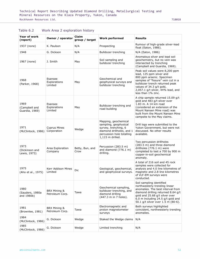
Technical Report Describing Updated Diamond Drilling, Metallurgical Testing and Mineral Resources on the Klaza Property, Yukon, Canada
Rockhaven Resources Ltd. 718018
amcconsultants.com 52
Table 6.2 Work Area 2 exploration history
Year of work (report)
Owner / operator Claim group / target
Work performed Results
1937 (none) K. Paulson N/A Prospecting Rumour of high-grade silver-lead float (Eaton, 1986).
1948 G. Dickson N/A Bulldozer trenching N/A (Eaton, 1986)
1967 (none) J. Smith May Soil sampling and bulldozer trenching
Anomalous silver and lead soil geochemistry, but no vein was intersected by trenching (Campbell and Guardia, 1969).
1968
(Parker, 1968)
Esansee Explorations Limited
May Geochemical and geophysical surveys and bulldozer trenching
Peak soil values were 8,200 ppm lead, 125 ppm silver and 800 ppm arsenic. Specimen samples of “fissure” vein cut in a bulldozer trench returned peak values of 34.3 g/t gold, 2,057.1 g/t silver, 44% lead, and less than 1% zinc.
1969
(Campbell and Guardia, 1969)
Esansee Explorations Limited
May Bulldozer trenching and road building
A chip sample returned 15.09 g/t gold and 483 g/t silver over 1.83 m. A 14 km road (considered an extension of the Mount Nansen Mine road) was built from the Mount Nansen Mine campsite to the May claims.
1971
(McClintock, 1986)
Cyprus Mines Corporation
Wedge
Mapping, geochemical sampling, geophysical survey, trenching, 6 diamond drillholes, and 1 percussion hole totalling 1,115 m drilled.
Drill logs were submitted to the Yukon Government, but were not discussed. No other results available.
1973
(Dickinson and Lewis, 1973)
Area Exploration Company
Betty, Bun, and Crow
Percussion (283.5 m) and diamond (776.1 m) drilling.
Two percussion drillholes (283.5 m) and three diamond drillholes (776.1 m) were completed to test a 700 by 900 m copper-in-soil geochemical anomaly.
1975
(Aho et al., 1975)
Kerr Addison Mines Limited
Dic Geological, geochemical, and geophysical surveys.
A total of 216 soil and 45 rock samples were collected for analysis and 4.0 line kilometres of
magnetic and 2.8 line kilometres of VLF-EM surveys were conducted.
1980
(Sauders, 1980a and 1980b)
BRX Mining & Petroleum Corp.
Tawa
Geochemical sampling, bulldozer trenching, and diamond drilling (447.3 m in 7 holes).
Soil sampling identified northwesterly trending linear anomalies. The best interval from diamond drilling returned 8.64 g/t gold and 25.68 g/t silver over 6.0 m including 24.5 g/t gold and 50.1 g/t silver over 1.5 m (80-6).
1981
(Brownlee, 1981)
BRX Mining & Petroleum Corp.
Tawa Electromagnetic and proton magnetometer surveys
Both surveys highlighted coincident, northwesterly trending anomalies.
1984
(McClintock, 1986) G. Dickson Wedge Staked the Wedge claims N/A
1985
(McClintock, 1986) G. Dickson Wedge Limited trenching N/A

Technical Report Describing Updated Diamond Drilling, Metallurgical Testing and Mineral Resources on the Klaza Property, Yukon, Canada
Rockhaven Resources Ltd. 718018
amcconsultants.com 53
Year of work (report)
Owner / operator Claim group / target
Work performed Results
1986
(McClintock, 1986)
Pearl Resources Ltd.
Wedge 222 soil geochemical samples
Identified several NW trending soil anomalies (Au, Ag, Pb, and Zn).
1986
(Heberlein and Lyons, 1986)
Kerr Addison Mines Ltd.
Vic, VG
Mapping, sampling, geophysical surveys, trenching, and diamond drilling.
Magnetometer survey matched known alteration zones and highlighted possible extensions of these zones. Drilling revealed that quartz veining is discontinuous.
1986
(Eaton, 1986)
Chevron Minerals Limited
Tawa
Mapping, prospecting, bulldozer trenching and an electromagnetic survey.
Deepening historical trenches returned 5.28 g/t gold and 132.0 g/t silver over 2 m. Geophysical and geochemical anomalies extended to 1,900 and 2,000 m, respectively.
1986
(McClintock, 1986)
Pearl Resources Ltd.
Etzel Geological mapping and geochemical sampling.
Geochemical sampling returning gold-in-soil values up to 310 ppb and silver-in-soil values up to 54.5 ppm. The best chip sample returned 0.99 g/t gold over 1 m.
1987
(Eaton and Walls, 1987)
Chevron Minerals Limited
Tawa
Road building, bulldozer trenching and claim staking.
Trench T-11 at the Klaza zone returned 4.22 g/t gold and 47.3 g/t silver over 8.0 m including 4.27 g/t gold and 86.7 g/t silver over 1.0 m. Trenching at the BRX zone intersected 3.12 g/t gold and 46.3 g/t silver over 7.0 m including 6.99 g/t gold and 41.1 g/t silver over 1.5 m (T-14) and 6.86 g/t gold and 160.1 g/t silver over 2.5 m (T-16).
1988
(Eaton and Walls, 1988)
Chevron Minerals Limited
Tawa
Excavator trenching (1,924 m) and six diamond drillholes (377 m).
Trenching exposed a vein in T-22 that returned 16.3 g/t gold and 1,289.1 g/t silver over 1.7 m. A drillhole testing the down-dip continuity of this interval returned 6.03 g/t gold and 129.9 g/t silver over 1.36 m (Hole 88-6).
1988 (Sutherland, 1988)
Chesbar Resources Inc.
Dic
Stream sediment sampling, prospecting and trenching.
Silt sampling returned values up to 1,050 ppb gold, while 75% of values were less than 10 ppb gold. Prospecting yielded a peak value of 220 ppb gold. Historical trenches (7.8 km) were deepened, but hindered by frozen ground.
1989
(Eaton, 1989)
BYG Natural Resources Inc. and Chevron Minerals Ltd.
Tawa Road construction and excavator trenching (580 m).
N/A
1992
(Langdon, 1992)
Aurchem Exploration
Wedge RC drilling
RC drilling confirmed anomalies identified by geophysics, trenching, and soil geochemistry. Some samples returned Cu-Mo anomalies, with minor Au and Ag.
1996
(Dujakovic et al., 1996)
BYG Natural Resources Inc.
Tawa, KR and Dic
Very low frequency electromagnetic,
magnetic (VLF-EM) and geochemical surveys.
Northwesterly trending VLF-EM and magnetic anomalies and soil geochemical values up to

Technical Report Describing Updated Diamond Drilling, Metallurgical Testing and Mineral Resources on the Klaza Property, Yukon, Canada
Rockhaven Resources Ltd. 718018
amcconsultants.com 54
Year of work (report)
Owner / operator Claim group / target
Work performed Results
1,825 ppb gold and 1,049 ppm copper.
1999
(Stroshein, 1999)
BYG Natural Resources Inc.
Gerald and Tawa Overburden stripping and diamond drilling (307.8 m in 3 holes).
Klaza zone drilling returned 3.82 g/t gold and 84.7 g/t silver over 5.05 m (TA-98-8). BRX zone drilling returned 0.24 g/t gold and 1.3 g/t silver over 55.75 m (TA-98-9).
2001
(Stroshein, 2001)
Aurchem Exploration
Vic
Prospecting, soil sampling, 3 trenches exposing Au-bearing quartz veins.
Trenching exposed faults post-dating mineralization.
2001
(Stroshein, 2001)
Aurchem Exploration
Wedge
Mapping, soil sampling, and trenching collecting 42 chip samples.
Silicification was revealed in trenches. Chip samples have anomalous Au and Ag.
2002
(Stroshein, 2003)
Aurchem Exploration
Vic Prospecting, mapping, geochemical sampling, trenching.
Best trench assays were 2.55 g/t Au over 5.4 m.
2003
(Stroshein, 2004)
Aurchem Exploration
Vic, JCS
Prospecting, 816 soil samples on Vic claims, 173 samples on JCS claims, 5 trenches, and 122 chip / grab / float samples.
Trenching revealed quartz breccia vein zone and a quartz stringer zone, both bearing Au.
2003
(Stroshein, 2004)
Aurchem Exploration Ltd.
Etzel Excavator trenching
The best trench result was from a clay-rich zone that graded 6.05 g/t gold and 15.3 g/t silver over 6.0 m.
2004-2006
(Ellemers and Stroshein, 2005; Stroshein, 2008)
Aurchem Exploration
Vic Trenching, RC drilling, and diamond drilling.
2004 drilling found grades of 12.68 g/t Au over 1.22 m and 2.56 g/t Au over 1.07 m in the 28 Main zone. The 28 Extension veining appears to be discontinuous.
2005
(Wengzynowski, 2006)
ATAC Resources Ltd.
Klaza
Staked Klaza 1-24 claims before optioning them to Bannockburn Resources Limited.
N/A
2007
(Stroshein, 2008)
Aurchem Exploration
Vic Soil geochemistry sampling, trenching, and 63 chip samples.
Veins are associated with porphyry dykes and fault zones trending 80-115, steeply
dipping N and S. Average Maverick vein samples graded at 49.89 g/t Au. Average 2,650 vein samples graded 16.01 g/t Au.
2009
(Turner and Tarswell, 2011)
ATAC Resources Ltd. – Rockhaven Resources Ltd.
Klaza ATAC sold the Klaza 1-24 claims to Rockhaven Resources Ltd.
N/A
Includes work carried out by Issuer
2010
(Turner and Tarswell, 2011)
Rockhaven Resources Ltd.
Klaza
Claim staking, geophysical surveying, diamond drilling, excavator trenching, and soil geochemical sampling.
Best drill intercept returned 3.23 g/t gold and 117.7 g/t silver over 36.50 m. Several additional coincident geochemical and geophysical anomalies were identified. Peak soil geochemical values were 856 ppb gold, 5.8 ppm silver, 494 ppm lead and 349 ppm arsenic.

Technical Report Describing Updated Diamond Drilling, Metallurgical Testing and Mineral Resources on the Klaza Property, Yukon, Canada
Rockhaven Resources Ltd. 718018
amcconsultants.com 55
Year of work (report)
Owner / operator Claim group / target
Work performed Results
2011 (Tarswell and Turner, 2012)
Rockhaven Resources Ltd.
Klaza
Geophysical surveying, diamond and reverse circulation drilling, excavator trenching, soil geochemical sampling, and air photo surveys.
Best drill intercept returned 5.43 g/t gold and 50 g/t silver over 14.80 m. Peak soil geochemical values were 320 ppb gold, 61.3 ppm silver, 606 ppm lead and 213 ppm arsenic.
2011
(Great Bear Resource, 2012a)
Great Bear Resources
Ltd.
Etzel
Diamond drilling, excavator trenching, and soil geochemical sampling.
Best drill intercept returned 0.58 g/t gold and 2.4 g/t silver over 40.65 m.
2012
(Great Bear Resource, 2012b)
Great Bear Resources
Ltd.
Etzel Diamond drilling and soil geochemical sampling.
Best drill intercept returned 2.30 g/t gold and 7.0 g/t silver over 1.16 m.
2012 Rockhaven Resources Ltd.
Dic and Eagle Purchased Dic and Eagle claims from J. Dickson
N/A
2012
(Tarswell and Turner, 2013)
Rockhaven Resources Ltd.
Klaza, Dic and Eagle
Diamond drilling, excavator trenching, and soil geochemical sampling.
Best drill intercept returned 5.78 g/t gold and 111 g/t silver over 15.62 m. Peak soil geochemical values were 920 ppb gold, 20.9 ppm silver, 722 ppm lead and 1,750 ppm arsenic.
2012 Rockhaven Resources Ltd.
Etzel Purchased Etzel claims from Ansell Capital Corp.
N/A
2012 Rockhaven Resources Ltd.
VIC, VG, J. Bill#, D, Bull, JBF and Jon-Wedge
Purchased claims from Aurchem Exploration Ltd.
N/A
2013
(Tarswell and Turner, 2014)
Rockhaven Resources Ltd.
Klaza Excavator trenching Best trench result was 5.61 g/t gold and 300 g/t silver over 18.79 m
2014
(Dumala, Tarswell and Turner, 2014)
Rockhaven Resources Ltd.
Klaza
Geophysical surveys, excavator trenching, diamond drilling, and metallurgical testing.
Best drill intercept returned 16.29 g/t gold and 1,435 g/t silver over 1.37 m.
Source: Archer, Cathro & Associates (1981) Limited.
The main exploration programs and results for Work Area 2 are described in more detail in the
technical report entitled “Geology, Mineralization, Geochemical Surveys, Geophysical Surveys,
Diamond and Percussion Drilling, Metallurgical Testing and Mineral Resources on the Klaza Property,
Yukon, Canada” dated 11 March 2015 and amended 19 June 2015 (Wengzynowski et al., 2015).
In 2005, ATAC Resources Ltd. (ATAC) staked the Klaza 1 – 24 claims, which form the core of Work
Area 2. Rockhaven purchased the Klaza claims from ATAC in 2009.
In June 2011, Ansell Capital Corp. (Ansell) purchased the Etzel claims from Aurchem Exploration
Ltd. (Aurchem). Rockhaven purchased the Etzel claims from Ansell in 2012 along with the VG, VIC,
J. Bill#, D, Bull, JBF, and Jon-Wedge claims from Aurchem. These claims now form the eastern edge
of Work Area 2.
In fall 2011, Rockhaven purchased the Dic and Eagle claims from Aurchem. These claims adjoin the
Klaza claims and are the southernmost claims in Work Area 2.

Technical Report Describing Updated Diamond Drilling, Metallurgical Testing and Mineral Resources on the Klaza Property, Yukon, Canada
Rockhaven Resources Ltd. 718018
amcconsultants.com 56
Table 6.3 Work Area 3 exploration history
Year of work (report)
Owner / operator
Claim group / target
Work performed Results
1987
(Hulstein, 1988)
G. Dickson
Nulee, JS, Moon, and Robert
Mapping, trenching, and geochemical sampling.
The Bear zone returned anomalous soil geochemistry. The source of Montgomery Creek zone anomalous float was untraceable.
1989
(Brent, 1991) E. Curley Grizzly
4 bulldozer trenches, hand trenching, and rock samples.
Trench intervals of 7.2 g/t Au over 3.5 m and 15.4 g/t Au over 1.5 m.
1990
(Brent, 1991) E. Curley Grizzly
8 trenches, chip sampling, and mapping.
Located felsic dykes associated with the Grizzly Vein (now the V1 vein). A grab sample graded 42.5 g/t Au, 57.9 g/t Ag, >3% As, 185 ppm Cu, 28 ppm Mo, 979 ppm Pb, 91 ppm Sb,
34 ppm W, and 410 ppb Hg.
1994
(Pautler, 1994)
E. Curley, Teck Corporation
Grizzly Trench mapping and rock sampling.
Trench chip samples graded at 3.52 g/t Au and 8.8 g/t Ag over 1.5 m.
2003
(Hulstein, 2003)
J. Dickson JRW Prospecting, chip samples, and soil sampling to explore V1.
Vein samples ran 1.24 g/t Au, 6,756 ppm As, 68.3 ppm Bi, and 51.2 ppm W over 2.2 m. Soil geochemistry revealed an anomaly containing 31.3 ppb Au, 53.1 ppm As, and 1.5 ppm Bi.
2009
(Smith, 2010) Strategic Dade
Staked the Dade 1-16 claims and ran a small soil geochemistry grid. Dade claims 17-96 were staked after assay results were returned.
Soil anomalies graded up to 113 ppb Au, while samples from trench floors ran 4,280 ppb Au.
2011
(Smith, 2011) Wolverine Dade
CanDig and excavator trenching, soil geochemistry, and geophysical surveys.
Trenching verified V1 and located V2 veining and stockwork.
2012
(Burrell, 2013a)
Strategic Dade
23 diamond drillholes totalling 2,043.39 m and 24 RC drillholes totalling 1,426.47 m.
Diamond holes did not intersect quartz veining, but found some results in alteration zones such as 2.45 g/t Au over 1.37 m. RC drilling had few significant intervals, including 5.32 g/t Au over 1.53 m.
Source: Archer, Cathro & Associates (1981) Limited.
In December 2009, Strategic staked the Dade 1 – 16 claims and sold them to Rockhaven in 2015.
Table 6.4 Work Area 4 exploration history
Year of work (report)
Owner / operator Claim group / target
Work performed Results
1934
(none) G. Dickson Val
Staked the Billy claims (now called Val).
N/A
1958
(Robinson, 1959)
Asbestos Corporation Ltd.
Val Optioned the Billy claims, mapping, trenching, packsack drilling.
Exposed a quartz-feldspar porphyry dyke; alteration with galena and pyrite.
1979 Rex Silver Mines Ltd. (formerly Peso Silver Mines Ltd.)
Val Transferred the Val property to Schweizerische Geselleschaft.
N/A
1981 Mount Nansen Corporation
Val Acquired the Val property. N/A

Technical Report Describing Updated Diamond Drilling, Metallurgical Testing and Mineral Resources on the Klaza Property, Yukon, Canada
Rockhaven Resources Ltd. 718018
amcconsultants.com 57
Year of work (report)
Owner / operator Claim group / target
Work performed Results
1981 BYG Natural Resources
Val Re-staked some of the Val area as DD claims.
N/A
1983 Mount Nansen Corporation
Val Conducted a feasibility study. N/A
1984 BYG Natural Resources
Val Purchased the Val property. N/A
1985 BYG Natural Resources
Val Re-staked some Val claims as ONT claims; Chevron Minerals Ltd optioned some claims.
N/A
1986-1988 BYG Natural Resources
Val
Ran an exploration program including mapping, soil geochemistry, geophysical surveys, trenching, and diamond drilling.
Identified a multi-element anomaly (Au, Ag, Zn, Sb, As, Cd, Bi, Cu, Mo) trending N-NW.
1988 Chevron Minerals Ltd.
Val Dropped its options. N/A
1995
(Carlyle, 1997)
E. Curley Queen Prospecting and surface mapping.
Located quartz-feldspar porphyry dykes.
1997
(Carlyle, 1997)
E. Curley Queen Program included geochemical soil sampling followed by trenching.
Soil geochemistry and trench samples gave low Au values (138 ppb Au and 47 ppb Au, respectively).
2003 Mr. Trerice Val Staked the Val claims. N/A
Includes work carried out by Issuer
2011 Rockhaven Resources Ltd.
Val Signed an option agreement for the Val property.
N/A
2012 Rockhaven Resources Ltd.
Val Carried out geochemical soil sampling.
N/A
2013 Rockhaven Resources Ltd.
Val Ran a two trench program.
Collected 82 samples over 330 m of trenching, locating mineralized veins below soil anomalies. Trenches returned 3.09 g/t Au with 5.93 g/t Ag over 1.00 m and 1.91 g/t Au with 131 g/t Ag over 1.30 m.
Source: Archer, Cathro & Associates (1981) Limited.
The Val claims were staked by Mr Trerice in 2003 in conjunction with placer activities along Back
Creek. 38857 Yukon Inc. currently owns the placer claims on Back Creek. Rockhaven signed an
option agreement with Mr Trerice on 21 September 2011, acquiring the right to earn a 100% interest
in the Val property. In 2015, Rockhaven purchased a 100% interest in the Val property.
Table 6.5 Work Area 5 exploration history
Year of work (report)
Owner / operator Claim group / target
Work performed Results
1996
Conquest Yellowknife Resources Ltd.
Cow (Nor)
Geophysics VLF-EM, magnetometer. (Restaked as Nor claims by Strategic in 2015).
Delineated multiple VLF-EM and magnetic anomalies.
Source: Archer, Cathro & Associates (1981) Limited.

Technical Report Describing Updated Diamond Drilling, Metallurgical Testing and Mineral Resources on the Klaza Property, Yukon, Canada
Rockhaven Resources Ltd. 718018
amcconsultants.com 58
Table 6.6 Work Area 6 exploration history
Year of work (report)
Owner / operator Claim group / target
Work performed Results
1965 Mount Nansen Mines Ltd
Bit Staked Bit claims 1-6 N/A
1966 Mount Nansen Mines Ltd
Bit Mapping and geochemical sampling
N/A
1971 Area Exploration Company Ltd
Bit, Rusk Optioned the Bit claims and staked Rusk claim 1-39
N/A
1972 Area Exploration Company Ltd
Rusk Grid soil sampling N/A
1973 Area Exploration Company Ltd
Rusk Drilled one diamond drillhole N/A
1974 J. Dickson Lone Staking around the Lone porphyry
N/A
1976 G. Dickson LD, Swiss Restaked as LD cl 1-14 N/A
1979 G. Dickson LD, Swiss Restaked as Swiss cl 1-62 N/A
1980 G. Dickson LD, Swiss Trenching N/A
1981 G. Dickson LD, Swiss Trenching N/A
1983 G. Dickson J. Bill Restaked as J. Bill cl 1-32 N/A
1984 G. Dickson Rat, Bull Trenching, added Rat c1 1-24 and Bull cl 1-28
N/A
1984 Kerr Addison Mines Ltd.
Lone Prospecting Rock samples yeilding peak values of 1.65 g/t gold and 14.8 g/t silver.
1985 Kerr Addison Mines Ltd.
Lone Staking the Only claims N/A
1986 Kerr Addison Mines Ltd.
Lone Mapping, soil sampling, and VLF surveys
Identified VLF-EM northwest trending linear anomalies. Peak gold-in-soil of 150 ppb.
1987 E. Curley Dows Dows claims were staked. Hand trenching.
N/A
1988 Noranda Exploration Company Ltd
Dows
Optioned and expanded the Dows claims. Mapping, grid soil sampling, mechanized trenching, and geophysical surveys.
Two best soil samples returned: 1,100 ppb gold, 2.0 ppm silver, 460 ppm arsenic and 1,100 ppb mercury; and, 490 ppb gold, 4.4 ppm silver, 1,100 ppm arsenic, and 13,200 ppb mercury, respectively.
1988 Kerr Addison Mines Ltd.
Lone Soil sampling and hand trenching
The best rock sample retruned 115 ppb gold, 555 ppm copper, and 115 ppb silver.
1989 Noranda Exploration Company Ltd
Dows One diamond drillhole Intersected a quartz breccia, which averaged 2.43 g/t gold over 7.5 m including 10.2 g/t gold over 1.5 m.
1995 Atna Resources Ltd.
Dows
Optioned Dows claims from E. Curley. Mapping, trenching, soil sampling, chip sampling.
N/A
1995 Conquest Yellowknife Resources Ltd.
Dows Optioned the property from Atna. Staked the Dows 119-124 claims.
N/A
1995 Aurchem Exploration Ltd
J. Bill, Rat, Bull Aurchem acquired Dickson’s claims J Bill, Rat, and Bull.
N/A

Technical Report Describing Updated Diamond Drilling, Metallurgical Testing and Mineral Resources on the Klaza Property, Yukon, Canada
Rockhaven Resources Ltd. 718018
amcconsultants.com 59
Year of work (report)
Owner / operator Claim group / target
Work performed Results
1996 Conquest Yellowknife Resources Ltd.
Dows Diamond drilling
Anomalous drill intercepts, 0.51 g/t gold and 13.13 g/t silver over 2.61 m (DDH-96-2); 6.64 g/t with low silver over 5.90 m (DDH-96-6); and 0.34 g/t gold and 5.09 g/t silver over 11.10 m (DDH-96-8).
2003 Aurchem Exploration Ltd
J. Bill Limited soil sample program. Pre-stripping for future trenching.
N/A
2006 R. Hulstein Desk Staked expired, Dows claims as Desk.
N/A
2007 Aurchem Exploration Ltd
J. Bill Trenching and sampling stripped areas from 2003.
N/A
2009 Strategic Metals Ltd.
Sked Stakes Sked claims N/A
2010 Strategic Metals Ltd.
Sked Grid soil sampling
The best results from soil sampling were strongly anomalous arsenic (up to 181 ppm) and copper (up to 140 ppm) and background to weakly anomalous gold (up to 23 ppb), lead (up to 14 ppm) and zinc (up to 85 ppm).
2010 Wolverine Minerals Corp.
Desk, Sked Wolverine purchased Desk and Sked claims.
N/A
Source: Archer, Cathro & Associates (1981) Limited.
In 1983 G. Dickson staked the J. Bill 1-32 and expanded by adding the Rat claims 1 – 24 to the
south in 1983 and the Bull claims 1-8 to the east in 1984. In 1994 the J. Bill, Rat, and Bull claims
were transferred to Dickson's widow, J. Dickson (YGS Minfile 115I 096).
The Desk claims were staked by R. Hulstein in 2006.
In winter 2009, Strategic staked the Sked claims to cover the potential along-strike extension of
the mineralized zone on the Desk claims. In summer 2010, Strategic expanded the property to the
northwest to cover a historical gold anomaly mapped on the west side of an unnamed tributary of
Lonely Creek (Chung, 2011).
In summer 2015, Rockhaven purchased the J.Bill, Rat, Bull, Desk, and Sked claims.
The Lone claims were restaked by Rockhaven in summer of 2017.

Technical Report Describing Updated Diamond Drilling, Metallurgical Testing and Mineral Resources on the Klaza Property, Yukon, Canada
Rockhaven Resources Ltd. 718018
amcconsultants.com 60
7 Geological setting and mineralization
7.1 Regional geology
The area underlain by the Property was visited by J.B. Tyrrell and D.D. Cairnes for the Geological
Survey of Canada (“GSC”) in 1898 and 1914, respectively, and has been mapped by H.S. Bostock
(1936), D.J. Tempelman-Kluit (1974 and 1984) and G.G. Carlson (1987). The geology was revised
in a compilation by Gordey and Makepeace (2000). Most recently, the GSC remapped the Mount
Nansen area in 2016 (Ryan, et al., 2016) The following discussion is primarily based on maps
prepared by Gordey and Makepeace, the Yukon Geological Survey (YGS) website and the most
recent mapping by the GSC.
The Property lies within the Yukon-Tanana Terrane (YTT) approximately 100 km southwest of the
Tintina Fault and 100 km northeast of the Denali Fault (Figure 7.1). YTT comprises a variety of
Proterozoic and Paleozoic metavolcanic, metasedimentary and metaplutonic rocks, and represents
both arc and back-arc environments (Colpron et al., 2006; Piercey et al., 2006). The Tintina Fault
is a transcurrent structure that experienced about 450 km of dextral strike-slip movement during
the Eocene. This movement offset an outlier of YTT in the Finlayson Lake District of south eastern
Yukon from the main body of YTT, which lies southwest of the fault. The Denali Fault is another
major transcurrent structure that has seen hundreds of kilometres of dextral strike-slip movement.
Regional lithologies in the area of the Property are summarized in Table 7.1. The basement rocks
are mainly schists and gneisses, which include metaplutonic, metasedimentary and metavolcanic
rocks (Simpson Range Suite and Snowcap and Finlayson Assemblages) (Ryan et al., 2016).
Basement rocks are cut by weakly foliated plutonic rocks (Long Lake Suite) that were
metamorphosed and uplifted in the Jurassic, along with the schists and gneisses. The youngest
rocks are unfoliated and are represented by five plutonic / volcanic events that occurred in the
Cretaceous and Tertiary (Whitehorse Suite, Mount Nansen volcanics, Prospector Mountain Suite,
Carmacks volcanics and the newly identified, Casino Suite) (Sanchez et al., 2014). The Casino Suite
is of particular significance, because it is associated with most of the epithermal vein and porphyry
deposits in the Dawson Range Gold Belt. Intrusions related to the Casino Suite were emplaced from
72 to 79 million years (Ma).

Technical Report Describing Updated Diamond Drilling, Metallurgical Testing and Mineral Resources on the Klaza Property, Yukon, Canada
Rockhaven Resources Ltd. 718018
amcconsultants.com 61
Figure 7.1 Regional geology and tectonic setting Klaza Property
Source: Archer, Cathro & Associates (1981) Limited.

Technical Report Describing Updated Diamond Drilling, Metallurgical Testing and Mineral Resources on the Klaza Property, Yukon, Canada
Rockhaven Resources Ltd. 718018
amcconsultants.com 62
Table 7.1 Regional lithologies
Upper Cretaceous
uKC: Carmacks Group
A volcanic succession dominated by basic volcanic strata (1), but including felsic volcanic rocks dominantly (?) at the base of the succession (2) and locally, basal clastic strata (3) (70 ma approx):
1 Augite olivine basalt and breccia; hornblende feldspar porphyry andesite and dacite flows; vesicular, augite phyric andesite and trachyte; minor sandy tuff, granite boulder conglomerate, agglomerate and associated epiclastic rocks (Carmacks Gp., Little Ridge Volcanics, Casino Volcanics).
2 Acid vitric crystal tuff, lapilli tuff and welded tuff including feeder plugs and necks; felsic volcanic flow rocks and quartz feldspar porphyries; green and purple massive tuff-breccia with feldspar phyric fragments (Carmacks Gp., Donjek Volcanics, some rocks formerly mapped as Mount Nansen Gp.; the felsic part of the Carmacks Gp. is difficult to distinguish from similar Tertiary and Mid- Cretaceous (Mount Nansen) felsic volcanic strata).
3 Medium bedded, poorly sorted, coarse to fine-grained sandstone, pebble conglomerate, shale, tuff, and coal; massive to thick bedded locally derived granite or quartzite pebble to boulder conglomerate (Carmacks Gp.).
Late Cretaceous to Tertiary
LKgP: Prospector Mountain Suite
Grey, fine to coarse-grained, massive, granitic rocks of felsic (q), intermediate (g) and rarely mafic (d) composition plus related felsic dykes (f):
q. Quartz monzonite, biotite quartz rich granite; porphyritic alaskite and granite with plagioclase and quartz-eye phenocrysts; biotite and hornblende quartz monzodiorite, granite, and leucocratic granodiorite with local alkali feldspar phenocrysts (Prospector Mountain Suite, Carcross Pluton).
g. Hornblende-biotite granodiorite, hornblende diorite, quartz diorite
(Wheaton Valley Granodiorite).
d. Coarsely crystalline gabbro and diorite.
f. Quartz-feldspar porphyry.
LKgC: Casino Suite
Grey fine to coarse-grained, massive granitic rocks of intermediate (g) composition and related felsick dykes (f):
g. hornblende-biotite granodiorite, hornblende diorite, quartz diorite (Wheaton Valley Granodiorite)
f. quartz-feldspar porphyry
Mid-Cretaceous
mKN: Mount Nansen Group
Massive aphyric or feldspar-phyric andesite to dacite flows, breccia and tuff; massive, heterolithic, quartz- and feldspar-phyric, felsic lapilli tuff; flow-banded quartz-phyric rhyolite and quartz-feldspar porphyry plugs, dykes, sills and breccia (Mount Nansen Gp., Byng Creek Volcanics, Hutshi Gp.).
mKW: Whitehorse Suite
Grey, medium to coarse-grained, generally equigranular granitic rocks of felsic (q), intermediate (g), locally mafic (d) and rarely syenitic (y) composition:
q. Biotite quartz-monzonite, biotite granite and leucogranite, pink granophyric quartz monzonite, porphyritic biotite leucogranite, locally porphyritic (K-feldspar) hornblende monzonite to syenite, and locally porphyritic leucocratic quartz monzonite (Mount McIntyre Suite, Whitehorse Suite, Casino Intrusions, Mount Ward Granite, Coffee Creek Granite).
g. Biotite-hornblende granodiorite, hornblende quartz diorite and hornblende diorite; leucocratic, biotite hornblende granodiorite locally with sparse grey and pink potassium feldspar phenocrysts (Whitehorse Suite, Casino Granodiorite, McClintock Granodiorite, Nisling Range Granodiorite).
d. Hornblende diorite, biotite-hornblende quartz diorite and mesocratic, often strongly magnetic, hypersthene-hornblende diorite, quartz diorite and gabbro (Whitehorse Suite, Coast Intrusions).
y. Hornblende syenite, grading to granite or granodiorite (Whitehorse Suite).
LKgC
uKC
LKgP
mKN
mKW

Technical Report Describing Updated Diamond Drilling, Metallurgical Testing and Mineral Resources on the Klaza Property, Yukon, Canada
Rockhaven Resources Ltd. 718018
amcconsultants.com 63
Early Jurassic
EJL: Long Lake Suite
Mostly felsic granitic rocks (q) but locally grading to syenitic (y):
q. Massive to weakly foliated, fine to coarse grained biotite, biotite- muscovite and biotite-hornblende quartz monzonite to granite, including abundant pegmatite and aplite phases; commonly K-feldspar megacrystic (Long Lake Suite).
y. Resistant, dark weathering, massive, coarse to very coarse-grained and porphyritic, mesocratic hornblende syenite; locally sheared, commonly fractured and saussuritized; locally has well developed layering of aligned pink K-feldspar tablets (Big Creek Syenite).
Late Triassic
LTrS: Stikinie Suite
Coarse-grained, foliated, gabbroic hornblende orthogneiss; coarse-grained hornblende-biotite granite and granodiorite with K-feldspar megacrysts; foliated, fine to medium-grained hornblende quartz diorite to diorite with minor biotite (Tally Ho leucogabbro, Friday Creek diorite, King Lake granite).
Upper Devonian to Lower Mississippian
DMF: Finlayson Assemblage
assemblage of mafic (v) to felsic (f) metavolcanic rocks of arc and back-arc affinities; carbonaceous pelite, metachert (bp); minor quartzite, metavolcaniclastic rocks (s); marble (c); ultramafic rocks and metagabbro (um):
v. Medium to dark green intermediate to mafic volcanic and volcaniclastic rocks; fine-grained amphibolite and greenstone (Little Kalzas, Ram Creek, Cleaver Lake, Tutchitua, Fire Lake fms; Big Salmon Complex).
f. Felsic metavolcanic rocks, white quartz-muscovite schist, metaporphyry (Kudz Ze Kayah, Wolverine, Waters Creeek fms).
bp. Dark grey to black carbonaceous metasedimentary rocks, metachert (Nisana, Swift River, Grass Lakes, Wolverine fms).
s. Light green to grey, fine-grained siliciclastic and metavolcaniclastic rocks; arkosic grit and sandstone; chert and minor limestone (Drury, Pelmac, Little Kalzas, Tutchitua fms; Big Salmon).
c. Light grey to white marble, locally crinoidal (Little Kalzas fm).
Um. Ultramafic rocks, serpentinite; metagabbro (Fire Lake fm).
Early Mississippian
MSR: Simpson Range Suite
Foliated granitoid of mainly granodiorite to tonalite compsition (g), locally granite and augen granite (q), rare gabbro (gb):
g. Foliated to strongly foliated, fine to medium-grained, hornblende-bearing metagranodiorite, metadiorite and metatonalite.
q. Foliated metagranite, quartz monzonite and granodiorite; augen granite.
gb. Locally metagabro
Neoproterozoic and Paleozoic
PDS: Snowcap Assemblage
Assemblage of dominantly metasiliciclastic rocks (s), minor marble (c), mafic metavolcanic rocks (v), and ultramafic rocks (um); intruded by Devonian-Mississippian calc-alkaline plutons of the Grass Lakes and Simpson suites; locally metamorphosed to blueschist and eclogite facies (e):
s. Polydeformed and metamorphosed quartzite, psammite, pelite and marble; minor greenstone and amphibolite (Snowcap, Dorsey, part of Big Salmon complexes; North River fm).
c. Light grey to buff weathering marble, generally lenticular and discontinueous.
v. Medium to coarse-grained amphibolite, commonly garnet-bearing; greenstone; minor marble (Snowcap, Dorsey complexes).
Um. Ultramafic rocks, serpentinite; metagrabbro; metapyroxenite (Dorsey complex).
e. Metasiliciclastic and mafic meta-ignewous rocks, locally metamorphosed to eclogite blueshist (Quiet Lake, Faro-Ross River, Simpson Lake).
Source: Archer, Cathro & Associates (1981) Limited. Modified after Gordey and Makepeace (2000).
EJL
DMF
MSR
PDS
LTrS:

Technical Report Describing Updated Diamond Drilling, Metallurgical Testing and Mineral Resources on the Klaza Property, Yukon, Canada
Rockhaven Resources Ltd. 718018
amcconsultants.com 64
7.2 Property geology
Detailed mapping on the Property has been limited by sparse outcrop exposure and extensive
vegetation cover. Cursory mapping has been done on the flank of Mount Nansen and from frost
boils in the Klaza River valley (Aho et al., 1975). The geology map shown in Figure 7.2 has been
interpreted from regional mapping, trenching, drilling and geophysical surveys, conducted on
various parts of the Property. This corresponds to Work Area 2 as discussed in Section 6.
Limited exploration or property mapping has been done by Rockhaven on the newly acquired claims.
The mineral occurrences are briefly discussed below in Section 7.3 but the information presented
has not been verified by either the QP or Rockhaven. The Property geology discussed below pertains
to Work Area 2.
The oldest exposed unit, comprised of Snowcap Assemblage schists, limestones and amphibolites,
underlies a large region to the west of the Property. To the south and east of the Property, large
bodies of orthogneiss belonging to the Simpson Range Suite surround younger Finlayson
Assemblage metavolcanics. Paleozoic units are sporadically intruded by irregular bodies of Stikine
Suite orthogneiss and granite.
The northern and western parts of the Property are mostly underlain by Mid-Cretaceous Whitehorse
Suite granodiorite. This granodiorite contains 30% hornblende and biotite. It is coarse-grained and
non-foliated.
Sub-aerial volcanic and volcaniclastic rocks of the Mount Nansen volcanics are common throughout
the central part of the Property. They include medium green to grey andesite flows and pyroclastic
rocks with occasional buff to tan rhyolitic tuff. These rocks are believed to be extrusive equivalents
of Middle Cretaceous intrusions.

Technical Report Describing Updated Diamond Drilling, Metallurgical Testing and Mineral Resources on the Klaza Property, Yukon, Canada
Rockhaven Resources Ltd. 718018
amcconsultants.com 65
Figure 7.2 Property geology – Klaza Property
Source: Archer, Cathro & Associates (1981) Limited.

Technical Report Describing Updated Diamond Drilling, Metallurgical Testing and Mineral Resources on the Klaza Property, Yukon, Canada
Rockhaven Resources Ltd. 718018
amcconsultants.com 66
A moderate size quartz-rich granite to quartz monzonite stock intrudes granodiorite in the southeast
corner of the map area and is thought to be the main heat source for hydrothermal cells responsible
for mineralization. This pluton, along with feldspar porphyry dykes scattered throughout the
Property, belong to the Casino Suite, which has been dated between Mount Nansen volcanics and
Prospector Mountain Suite formation (Isreal, pers. comm., 2014). Geochronological work indicates
that porphyry dykes, which are spatially and genetically related to porphyry and vein mineralization
on the Property, are Late Cretaceous (78.2 – 76.3 Ma) in age (Mortensen et al., 2016). The Casino
Suite is associated with most porphyry-style mineralization within the Dawson Range.
A series of northwesterly trending feldspar porphyry dykes, emanating from the stock in the south
eastern part of the map area, cut the Whitehorse Suite granodiorite in the main areas of interest.
These porphyry dykes are up to 30 m wide and consist of buff aphanitic groundmass containing up
to 15% orthoclase phenocrysts (1 to 2 millimetre (mm)) with minor biotite and rare quartz
phenocrysts. Commonly the dykes occupy the same structural zones as the mineralized veins, and
they are often strongly fractured. Some veins cross-cut dykes.
Two main fault trends (NW and NE) are present in the map area. The first set strikes northwesterly
and dips between 60 and 80° to the southwest. Although these faults lack strong topographic
expression, they are very important because they host mineralized veins and breccia zones and
appear to control the distribution of porphyry dykes. The second set of faults strike northeasterly,
almost perpendicular to the primary set, and dip sub-vertically. They form prominent topographic
linears and offset the mineralized zones in a number of places, creating apparent left lateral
displacements of up to 80 m in magnitude. The exact relationship between these structures and the
mineralized northwesterly trending structures is still uncertain, but they appear to have been in part
coeval and may have played an important role in ground preparation.
A third set of structures is slightly oblique to the main mineralized faults, striking more westerly.
They are less continuous and are considered to be Riedel shears. High-grade mineralization is
sometimes localized at junctions between these shears and the northwesterly trending structures.
7.3 Mineralization
The Property lies within the northern part of the Mount Nansen Gold Camp (MNGC), a northwest
trending structural belt that hosts more than 30 known mineral occurrences (Figure 7.3), several
of which are categorized as deposits and have produced historically and as recently as 1999 (Hart
and Langdon, 1997).
Mineralization within the MNGC is dominated by gold-silver rich structures associated with a
zonation model ranging from weak porphyry copper-molybdenum centres, outward to transitional
anastomosing sheeted veins, and lastly to more cohesive and continuous base and precious metal
veins. The age of the mineralizing events within the MNGC is now considered to be Late Cretaceous.

Technical Report Describing Updated Diamond Drilling, Metallurgical Testing and Mineral Resources on the Klaza Property, Yukon, Canada
Rockhaven Resources Ltd. 718018
amcconsultants.com 67
Figure 7.3 Mount Nansen Gold Camp – Klaza Property
Source: Archer, Cathro & Associates (1981) Limited.
Technical Report Describing Updated Diamond Drilling, Metallurgical Testing and Mineral Resources on the Klaza Property, Yukon, Canada
Rockhaven Resources Ltd. 718018
amcconsultants.com 68
7.3.1 Mineralization – Work Area 2
The hydrothermal system interpreted to have deposited mineralization in Work Area 2 is centred on
two porphyry centres (Cyprus and Kelly zones) related to Late Cretaceous plutonism. Mineralized
zones identified on and adjacent to the Work Area 2, and the generalized metal zonation model are
shown on Figure 7.4. The larger and better defined porphyry centre (Cyprus zone) is located in the
southeast corner of the map area. It was explored in the late 1960s and early 1970s with
approximately 4,500 m of drilling in 26 holes. Average hypogene grades of 0.12% copper and
0.01% molybdenum were reported at depths exceeding 60 to 90 m below surface. Hypogene copper
grades are approximately double those in the overlying leached cap. There is no significant
supergene enrichment zone. Higher grade zones (0.6% copper and 0.06% molybdenum) and
elevated precious metal values are associated with local areas of intensive fracturing (Sawyer and
Dickinson, 1976). These metal enriched zones are found in weakly potassic altered areas within the
dominantly phyllic altered porphyry system. The potassic altered areas often feature tourmaline
breccias, abundant quartz veining and / or secondary biotite.
The western porphyry centre (Kelly zone) is located on the Property and was explored as early as
1973. The Kelly zone is defined by coincident geochemical and geophysical anomalies, including: 1)
strongly elevated gold, copper and molybdenum soil geochemical response; 2) high chargeabilities
with moderate resistivities; and, 3) a large area of low magnetic susceptibility observed in both
ground and airborne surveys. The coincident anomalies cover a semicircular area approximately
2,500 m across. Trenching and diamond drilling done in 2012 by Rockhaven on the western edge
of the Kelly zone discovered minor chalcopyrite, chalcocite and molybdenum, with rare bornite. The
mineralization is hosted in several, 25 to 100 m wide bands of strongly phyllic altered and heavily
quartz veined granodiorite, which are separated by barren porphyry dykes.
Structurally controlled gold-silver mineralization in the core of the Property is interpreted to be
related to the hydrothermal system that is cored by the Cyprus and Kelly zones. Re-Os dating of
the Cyprus zone has established Late Cretaceous age for the pluton and the associated
mineralization (Mortensen et al., 2003).
The majority of Rockhaven’s exploration activities have been conducted in the distal part of the local
hydrothermal system where copper-deficient precious metal-rich veins predominate. This work has
identified ten main mineralized structural zones in Work Area 2 that are developed northwest of the
porphyry targets. The structural zones collectively form a 4 km long by 3 km wide corridor that cuts
northwesterly through Mid- Cretaceous granodiorite country rocks. Individual zones exhibit
exceptional lateral and down-dip continuity, and all of them remain open for extension along strike
and to depth. From south to north, the zones are named Chevron, Dickson, AEX, BRX, Pika,
Stroshein, Herc, BYG, Klaza, and Pearl. Rockhaven’s exploration has focused mainly on the Klaza
and BRX zones, which have been subdivided into the Western BRX, Central BRX, Eastern BRX,
Western Klaza, Central Klaza, and Eastern Klaza zones. The current Mineral Resource estimate
contains mineralization from the western and central zones.
The eastern portion of the mineralized structural zones comprises multiple, sub-parallel veins, that
include the Eastern Klaza, Eastern BRX, Pika, Stroshein, and part of the AEX zones, all of which are
open to the east, towards the mostly untested Kelly Porphyry.
The western portion of the main mineralized structural zones range from 1 to 100 m wide and are
usually associated with feldspar porphyry dykes. Mineralization occurs within veins, sheeted veinlets
and some tabular breccia bodies. The host granodiorite exhibits pervasive weak argillic alteration
immediately adjacent to, and up to 30 m peripherally from, them. Sericitization and potassic
alteration are developed directly adjacent to hydrothermal channel ways. The granodiorite is
magnetite-bearing except where the magnetite has been replaced by sulphide minerals around and
within mineralized structures.

Technical Report Describing Updated Diamond Drilling, Metallurgical Testing and Mineral Resources on the Klaza Property, Yukon, Canada
Rockhaven Resources Ltd. 718018
amcconsultants.com 69
Figure 7.4 Zones and zonation – Klaza Property
Source: Archer, Cathro & Associates (1981) Limited.
Technical Report Describing Updated Diamond Drilling, Metallurgical Testing and Mineral Resources on the Klaza Property, Yukon, Canada
Rockhaven Resources Ltd. 718018
amcconsultants.com 70
Depth of surface oxidation ranges from 5 to 100 m below surface, depending on fracture intensity,
the type of mineralization and local geomorphology. The deepest weathering occurs in wide, pyritic
veins located along ridge tops or on south facing slopes.
Detailed evaluation of oriented drill core and measurements taken from trench exposures has
identified two main structural orientations that control mineralization. The primary structural set
strikes between 135˚ and 155˚ and dips 60˚ to 80˚ to the southwest. The secondary mineralized
trend strikes between 110˚ and 130˚ and dips 60˚ to 70˚ to the south. The secondary structures
may represent either Riedel shears of the primary structural set or a separate structural event
altogether. The best gold mineralization is sometimes localized in areas where the two structural
trends converge. The plunge of these structural intersections is towards the southeast.
Petrographic work demonstrated veins, veinlets and breccia material hosting disseminated to
semi-massive pyrite, arsenopyrite, galena, sphalerite, stibnite, and jamesonite in quartz, carbonate,
and barite gangue (Payne, 2012). The sulphide minerals typically comprise 1 to 10% of the sample,
often increasing to between 20 and 80% over 25 to 200 cm intervals. The petrographic work also
identified native gold/electrum (Tarswell and Turner, 2012).
Quartz is the dominant gangue mineral in veins in Work Area 2. It occurs in a variety of textures
including chalcedonic, comb, banded, speckled and vuggy. Smoky quartz is the most common colour
variation, but milky and clear quartz are locally abundant. Carbonate occurs mainly as ankerite and
rhodochrosite and typically ranges between 5 and 20% of the veins by volume.
Breccias form tabular bodies consisting of heterolithic wallrock clasts, which include granodiorite
and various volcanic or sub-volcanic lithologies. Matrices are enriched with fine-grained,
disseminated to blebby pyrite, arsenopyrite, sphalerite and galena. Breccias are mostly observed
within drill core from the Klaza zone where they range up to 2 m in width.
Mineralization within most structures is interpreted to be spatially and genetically related to
porphyry dykes, which strike northwesterly and dip steeply to moderately toward the south. The
dykes pinch and swell in three dimensions and are usually unmineralized. Some faults identified to
date likely post-date emplacement of the dykes as they are occasionally cut by mineralized veins.
Two parallel, northeast trending faults have been observed to cut across the north western portion
of the Klaza and BRX zones. The easterly cross-fault appears to offset the western sections of the
mineralized zones about 80 m to the south; however, the exact sense of motion is uncertain.
Detailed exploration has not been conducted yet on the western side of the westerly cross-fault, so
displacement on it has not been determined. The westerly cross-fault appears to be a stronger
structure. The relative timing of movement on these faults has not yet been determined, but they
are thought to be coeval with, or slightly younger than, the vein structures. Some of the better
mineralized sections of the vein structures occur in what appear to be dilatant zones immediately
east of the cross-faults. Drillholes and trenches are aligned subparallel to the orientation of the
cross-faults – therefore only a few holes have intersected them. The extent to which the northeast
trending faults are mineralized is not yet known. In the Klaza zone, the easterly cross-fault marks
a sharp change in mineralogy with increasing arsenopyrite and sulphosalt contents coupled with
higher silver : gold ratios in the Western Klaza zone relative to the Central Klaza zone. At the BRX
zone, the same cross-fault separates bonanza-grade rhodochrosite-facies mineralization in the
Western BRX zone from lower-grade, iron-carbonate facies mineralization in the Central BRX zone.
For a more detailed description of mineralization, mineral paragenesis, alteration facies and gangue
facies, please refer to the technical report entitled “Geology, Mineralization, Geochemical Surveys,
Geophysical Surveys, Diamond and Percussion Drilling, Metallurgical Testing and Mineral Resources

Technical Report Describing Updated Diamond Drilling, Metallurgical Testing and Mineral Resources on the Klaza Property, Yukon, Canada
Rockhaven Resources Ltd. 718018
amcconsultants.com 71
on the Klaza Property, Yukon, Canada” dated 11 March 2015 and amended 19 June 2015
(Wengzynowski et al., 2015).
7.3.2 Mineralization – other work areas
Historical work on Rockhaven’s recently acquired claims identified various mineralized trends, which
warrant further investigation. The most noteworthy of these veins are found in Work Areas 3, 4,
and 6. Rockhaven has conducted limited mapping, prospecting, geochemical sampling, and
geophysical surveys on portions of the property outside of Work Area 2.
The known surface mineralization on the Dade claims (Work Area 3) is hosted in two, sinusoidal
zones of quartz veining and stockwork (V1 and V2) striking about 040° and dipping 60-75° north,
hosted in coarse-grained hornblende-quartz granodiorite to diorite gneiss (Burrell, 2013). V1
(formerly, the Grizzly Vein) and V2 are epithermal quartz vein and stockwork zones that exhibit
pervasive silicification and moderate to strong clay alteration. In 2011, trenching exposed V1 over
widths of 9 to 20 m along a 175 m strike length and V2 over widths of 2 to 12 m along a 125 m
strike length (Burrell, 2013). The veins comprise white to grey quartz with boxwork limonite and
locally 1 – 3% disseminated arsenopyrite and pyrite.
On the Val claims (Work Area 4), mineralization consists of fault-controlled, gold- and silver-bearing
veins, and breccias hosted within one structural zone (Turner, 2014). This zone ranges from 10 to
20 m wide and mineralization occurs within sheeted veins and veinlets. Sulphide minerals on the
Val claims consist of arsenopyrite, pyrite, galena and sphalerite and occur as disseminations and
stringers within quartz and carbonate gangue.
The J Bill, Rat, and Bull claims (Work Area 6) host two types of mineralization located about 500 m
west of the vein proximal to the contact of a silicified porphyry stock. One type of mineralization
consists of pyrite-arsenopyrite-galena-sphalerite-quartz, while the other is composed of finely
disseminated molybdenite and chalcopyrite with minor pyrite and pyrrhotite (YGS Minfile 115I 096).
The mineralized trend was traced for 1,150 m (YGS Minfile 115I 096).

Technical Report Describing Updated Diamond Drilling, Metallurgical Testing and Mineral Resources on the Klaza Property, Yukon, Canada
Rockhaven Resources Ltd. 718018
amcconsultants.com 72
8 Deposit types
8.1 Mineralization style on the Property
The metals of primary interest at the Property are gold and silver. These metals are intimately
associated with lead, zinc and copper in various forms and concentrations throughout the
mineralizing system. Gold and silver enriched mineralization is developed within a northwest
trending structural corridor, which is interpreted to have focused fluid flow away from weak porphyry
centres related to a Late Cretaceous stock in the south eastern corner of the Property. Several of
the mineralized structural zones are continuously mineralized for strike lengths of up to 2,400 m,
and at least one of the structures is mineralized to a depth of 520 m down-dip from the current
geographic surface. The mineralized structures remain open to extension along strike and down-
dip.
Fluid inclusion work reveals that the veins formed at shallow depths (<1 km) and have low to
intermediate sulfidation epithermal fluid characteristics (Main, 2015). Textures and mineralogy
observed at the Property share a number of similarities with Carbonate Base Metal (CBM) deposits
(Tarswell and Turner, 2013).
CBM deposits are a recently recognized sub-class of epithermal deposits that encompass a family
of similar deposits located around the world. CBM deposits have mainly been discovered around the
Pacific Rim and include multi-million ounce gold deposits such as Porgera (New Guinea), Buritica
(Colombia) and Kelian (Indonesia).
The CBM class of deposits has yet to be positively identified in the Yukon, but some researchers
have recognized that mineralization on the Property has some of the characteristics of mineralization
now categorized as CBM deposits (ex. Smuk, 1999). Given the limited academic research on the
Property and the absence of significant syn-mineralization carbonate, more studies need to be
undertaken.
Similarities and differences between CBM deposits and the Klaza mineralization are discussed below.
8.2 Characteristics of carbonate base metal gold deposits
CBM deposits are formed by the mixing of rising mineralized fluids with bicarbonate waters (Corbett
and Leach, 1998). Mineralization styles are highly zoned, depending on the crustal level of the
system, with silver-rich CBMs formed at higher levels. Characteristic zonation of carbonate
compositions develops when upwelling mineralizing fluids are progressively cooled as they mix with
descending bicarbonate groundwater. These carbonate compositions vary from proximal (hot)
calcium (Ca) through magnesium (Mg) and manganese (Mn) to distal (cool) iron (Fe) facies. Gold
mineralization is believed to be preferentially distributed within veins containing Mn / Mg carbonate
facies, notably rhodochrosite.
Key diagnostic features of CBM deposits are compared to features observed at the Property in Table
8.1.

Technical Report Describing Updated Diamond Drilling, Metallurgical Testing and Mineral Resources on the Klaza Property, Yukon, Canada
Rockhaven Resources Ltd. 718018
amcconsultants.com 73
Table 8.1 CBM comparison with BRX and Klaza zones
Diagnostic features of CBM deposits Diagnostic features of Klaza mineralization
Mineralization hosted in veins and breccias Mineralization hosted in veins and breccias
Large vertical extent of mineralization (> 1,000 m) Large vertical extent of mineralization (520 m and open to depth)
Gold and silver generally well liberated (native or in electrum)
Gold and silver generally well liberated (native gold, electrum, and silver in tetrahedrite)
Veins and breccias emplaced adjacent to mineralizing intrusive
Veins and breccias emplaced adjacent to mineralizing intrusive
Carbonate (dominant), quartz, pyrite, sphalerite, and galena gangue
Quartz (dominant), carbonate, pyrite, sphalerite, and galena gangue
Multiple mineralized structures with long strike lengths (> 700 m)
Multiple (eleven) mineralized structures with long strike lengths (> 2,400 m)
Bonanza grade gold mineralization Some bonanza grade intercepts
Source: Archer, Cathro & Associates (1981) Limited.
The CBM model is the geological concept on which exploration is planned. Although further studies
may place the Klaza mineralization into a more general epithermal category, this difference does
not materially affect the exploration strategy.

Technical Report Describing Updated Diamond Drilling, Metallurgical Testing and Mineral Resources on the Klaza Property, Yukon, Canada
Rockhaven Resources Ltd. 718018
amcconsultants.com 74
9 Exploration
Exploration programs performed by Rockhaven between 2010 and 2017 within the main area
of interest, Work Area 2, are described below, except for drilling which is discussed in detail in
Section 10. Work Areas 1 and 3 – 6 are on ground acquired by Rockhaven in the summer of 2015
and summer of 2017. Limited exploration work, comprising soil-geochemical sampling and
ground-based VLF-EM and magnetic surveys,has been conducted by Rockhaven on parts of Work
Areas 4 and 6. No exploration work has been completed on Work Areas 1, 3, and 5 by the issuer.
9.1 Geological mapping
Conventional geological mapping over much of the Property is hampered by the presence of
pervasive overburden and vegetation cover. Data obtained from sparse outcrops, excavator
trenching and drilling have been used in conjunction with information inferred from geophysical
surveys to create geological maps of Work Area 2.
9.2 Soil geochemical surveys
From 1967 to present, various operators collected soil geochemical samples from the eastern part
of Work Area 2. Historical samples were taken on baseline-controlled grids established using hip-
chain and compass. Baselines were marked with one metre high wooden lath and sample sites were
marked with 0.5 m wooden lath; however, very few of these markers are currently standing and
legible. Early soil sampling identified linear gold ± silver ± lead anomalies, which correspond to
some of the known mineralized structural zones, and a large (2,000 by 3,000 m) area of moderately
to strongly anomalous copper-in-soil response, which partially defines the Kelly porphyry target in
the south eastern corner of Work Area 2.
Grid soil sampling was performed within Work Area 2 by Rockhaven from 2010 to 2012, and 2015.
Contour - controlled lines were completed in the northwestern part of Work Area 2 and north eastern
part of Work Area 6. Soil sampling methods, spacing and analytical techniques are described in
Section 11.
Effectiveness of soil sampling is often limited by thick layers of organic material and overburden,
and in many areas, by permafrost. Despite these limitations, soil sampling has been one of the most
effective surface exploration techniques for identifying trenching or drilling targets on the Property.
Results for gold, silver, lead, arsenic, and copper from historical surveys and Rockhaven’s sampling
are illustrated together on Figure 9.1 to Figure 9.5, respectively using gradient contour techniques.
Table 9.1 lists the anomalous thresholds and peak values obtained by Rockhaven’s surveys for these
elements.
Table 9.1 Geochemical data for soil samples from Work Area 2
Anomalous thresholds Peak values
Element Weak Moderate Strong
Gold (ppb) ≥ 5 < 10 ≥ 10 < 20 ≥ 20 920
Silver (ppm) ≥ 0.5 < 1 ≥ 1 < 2 ≥ 2 61.3
Lead (ppm) ≥ 10 < 20 ≥ 20 < 50 ≥ 50 722
Copper (ppm) ≥ 20 < 50 ≥ 50 < 100 ≥ 100 1,870
Arsenic (ppm) ≥ 10 < 20 ≥ 20 < 50 ≥ 50 1,750
Source: Archer, Cathro & Associates (1981) Limited.
The structural corridor hosting the eleven known mineralized zones is defined by linear trends of
moderately to strongly anomalous values for gold, silver, lead, and arsenic. Similar but more

Technical Report Describing Updated Diamond Drilling, Metallurgical Testing and Mineral Resources on the Klaza Property, Yukon, Canada
Rockhaven Resources Ltd. 718018
amcconsultants.com 75
discontinuous anomalies have been identified southwest and northeast of the structural corridor,
where no mineralized zones have been discovered to date. Northwest along strike of the known
mineralized zones, elevated soil values occur as isolated samples or in small clusters. The lack of
continuity in these outlying anomalies may be due in part to more difficult sampling conditions
resulting from lower elevations and increased overburden depths.
Work Area 2 exhibits distinct copper zonation from east to west. Copper is strongest in the south
eastern part of the area, in proximity to the intrusive centre at the Kelly zone. Response across the
remainder of the gridded area is more subdued. The more southerly BRX, AEX, Dickson, and
Chevron zones have weakly elevated copper-in-soil signatures, while the other zones, further to the
north, show only background copper response.
Contour sampling at the Rusk showing, located in the southern corner of Work Area 2 and Northern
edge of Work Area 6, is characterized by coincident, strongly anomalous arsenic, silver, gold, and
lead.

Technical Report Describing Updated Diamond Drilling, Metallurgical Testing and Mineral Resources on the Klaza Property, Yukon, Canada
Rockhaven Resources Ltd. 718018
amcconsultants.com 76
Figure 9.1 Gold soil geochemical values – Work Area 2 Klaza Property
Source: Archer, Cathro & Associates (1981) Limited.

Technical Report Describing Updated Diamond Drilling, Metallurgical Testing and Mineral Resources on the Klaza Property, Yukon, Canada
Rockhaven Resources Ltd. 718018
amcconsultants.com 77
Figure 9.2 Silver soil geochemical values – Work Area 2 Klaza Property
Source: Archer, Cathro & Associates (1981) Limited.

Technical Report Describing Updated Diamond Drilling, Metallurgical Testing and Mineral Resources on the Klaza Property, Yukon, Canada
Rockhaven Resources Ltd. 718018
amcconsultants.com 78
Figure 9.3 Lead soil geochemical values – Work Area 2 Klaza Property
Source: Archer, Cathro & Associates (1981) Limited.

Technical Report Describing Updated Diamond Drilling, Metallurgical Testing and Mineral Resources on the Klaza Property, Yukon, Canada
Rockhaven Resources Ltd. 718018
amcconsultants.com 79
Figure 9.4 Arsenic soil geochemical values – Work Area 2 Klaza Property
Source: Archer, Cathro & Associates (1981) Limited.

Technical Report Describing Updated Diamond Drilling, Metallurgical Testing and Mineral Resources on the Klaza Property, Yukon, Canada
Rockhaven Resources Ltd. 718018
amcconsultants.com 80
Figure 9.5 Copper soil geochemical values – Work Area 2 Klaza Property
Source: Archer, Cathro & Associates (1981) Limited.

Technical Report Describing Updated Diamond Drilling, Metallurgical Testing and Mineral Resources on the Klaza Property, Yukon, Canada
Rockhaven Resources Ltd. 718018
amcconsultants.com 81
9.3 Excavator trenching
Excavator trenching in geochemically anomalous areas has been the most effective tool for
identifying near surface but non-outcropping, mineralized zones. Within the main areas of
exploration, overburden generally consists of 5 to 20 cm of vegetation and soil organics covering a
discontinuous layer of white volcanic ash and 50 to 125 cm of loess and / or residual soil, which cap
decomposed bedrock.
Typical trench exposures within the mineralized vein zones exhibit strong limonite and clay
alteration that is often water saturated and more deeply weathered than the surrounding wallrocks.
These zones are more intensely fractured and have higher porosity as a result of near surface
oxidation. Residual sulphide minerals are rarely present in trenches and, where seen, they are
usually encapsulated in silica. The locations and orientations of lithological contacts in trenches
correspond very well with those predicted from nearby drillholes, indicating little solifluction has
occurred. Outside of the mineralized zones, trench exposures are dominated by blocky, weakly
oxidized granodiorite.
Rockhaven performed 24,231 m of trenching in 101 trenches between 2010 and 2017. Table 9.2
lists the total number and combined lengths of trenches completed by Rockhaven each year during
that period.
Table 9.2 2010 to 2017 Excavator trenching summary
Year Number of trenches Total length (m)
2010 21 8,000
2011 12 4,050
2012 11 4,000
2013 38 5,000
2014 5 880
2015 2 436
2016 8 1,270
2017 4 595
Total 101 24,231
Source: Archer, Cathro & Associates (1981) Limited.
The majority of Rockhaven’s trench locations were selected based on results from historical
programs. Where possible, trenches were excavated in areas that had previously been stripped of
soil and vegetation. The trenches were aligned at about 030°, which is perpendicular to the
anomalous trends of the main soil geochemical anomalies. Figure 9.6 is a plan view map showing
Rockhaven’s trench locations and approximate surface traces of the nine main mineralized structural
zones. Excavator trenching methods and analytical techniques are described in Section 11.
Individual zones and key trench results obtained prior to 2016 are discussed in the technical report
entitled “Technical Report and PEA for the Klaza Au-Ag Deposit, Yukon, Canada for Rockhaven
Resources Ltd.” dated 26 February 2016 (Ross et al., 2016).
In 2016 and 2017, twelve trenches were dug. Locations of Klaza area trenches are shown in Figure
9.6.

Technical Report Describing Updated Diamond Drilling, Metallurgical Testing and Mineral Resources on the Klaza Property, Yukon, Canada
Rockhaven Resources Ltd. 718018
amcconsultants.com 82
Figure 9.6 Trench locations – Klaza Property
Note: 2016 and 2017 trenchs shown in pink. Source: Archer, Cathro & Associates (1981) Limited.

Technical Report Describing Updated Diamond Drilling, Metallurgical Testing and Mineral Resources on the Klaza Property, Yukon, Canada
Rockhaven Resources Ltd. 718018
amcconsultants.com 83
9.4 Geophysical surveys
To date, a number of geophysical surveys have been completed on Work Area 2 by four different
companies:
1 SJ Geophysics Ltd. of Delta, British Columbia conducted ground-based VLF-EM and magnetic
surveys on behalf of BYG Natural Resources Inc. in 1996 (Dujokovic et al., 1996) and
Rockhaven in 2014 (Dumala et al, 2015); and, a Volterra-3D IP survey in 2016 (Turner and
Cruz, 2018).
2 Aurora Geosciences Ltd. of Whitehorse, Yukon conducted a gradient array induced
polarization survey on behalf of Bannockburn Resources Limited in 2006 (Wengzynowski,
2006).
3 New-Sense Geophysics Ltd. (NSG) of Markham, Ontario conducted high sensitivity
helicopter-borne magnetic and gamma-ray spectrometric surveys for Rockhaven during the
2010 (Tarswell and Turner, 2011) and 2011 (Tarswell and Turner, 2012) field seasons.
4 Ground Truth Exploration of Dawson City, Yukon conducted high resolution induced
polarization surveys along two experimental lines in the Central Klaza and Central BRX zones
for Rockhaven during the 2013 field season (Tarswell and Turner, 2014).
The NSG surveys resulted in 326 line kilometres being flown on a grid that covered most of Work
Area 2. Condor Consulting Inc. of Lakewood, Colorado was retained to ensure quality control and
produced a 3D model of the total field magnetics as well as various vertical derivatives.
The magnetic surveys identified a number of prominent, linear magnetic lows in Work Area 2.
Subsequent trenching and drilling have shown that many of the northwesterly trending lows coincide
with mineralized structural zones, while northeasterly trending breaks in the magnetic patterns
correspond to cross-faults. These relationships are consistent with the low magnetic susceptibility
results returned from core samples within the altered structural zones compared to higher values
from surrounding unaltered wallrocks. Several of the magnetic lows extend outside the main areas
of exploration and have not yet been tested by drilling or trenching. Figure 9.7 shows the first
vertical derivative of the magnetic data overlain with the interpreted surface traces of the structural
zones.
Elevated potassic radioactivity is evident in the general area of the main zones in the eastern part
of Work Area 2 but does not specifically coincide with individual mineralized zones. Numerous
porphyry dykes and frost boils containing porphyry fragments lie within this area, and they are the
probable source of the elevated radioactivity. The Klaza River valley generally has a subdued
radiometric response, which is likely due to thick vegetation and water saturation in the flats
adjacent to the river. However, a band of elevated radioactivity that directly correlates with the bed
of the Klaza River may be caused by exposed gravels, which include abundant potassium feldspar
bearing, intrusive material.
The SJ Geophysics VLF-EM and ground-based magnetic surveys covered 330 line kilometres on a
4.5 by 8 km grid in the eastern and central part of Work Area 2. SJ Geophysics interpreted the data
and produced images relating to it. These surveys delineated numerous linear magnetic lows and
VLF-EM conductors that coincide with known mineralized zones. Northerly trending breaks in the
VLF-EM conductors correspond to known or suspected cross-faults. Figure 9.8 shows the results of
the VLF-EM survey overlain with the interpreted surface traces of the mineralized structural zones
and their possible extensions along strike.
A Volterra-3D IP survey was completed by SJ Geophysics in 2016 to the east of the deposit area. A
total of 18.4 line kilometres were completed on a grid with seven survey lines spaced at 400 m.
Survey stations along these lines were set up at 100 m intervals. The work was designed to better

Technical Report Describing Updated Diamond Drilling, Metallurgical Testing and Mineral Resources on the Klaza Property, Yukon, Canada
Rockhaven Resources Ltd. 718018
amcconsultants.com 84
define the Kelly Zone, where porphyry-style mineralization had been inferred from a few
widely-spaced drillholes, strong soil geochemistry and a broad magnetic low. This survey identified
a 2,400 m by 2,200 m sub-circular chargeability anomaly containing greater than
40 millisecond (ms) values, as shown in Figure 9.9. Within this anomaly there is a 1,700 m by
800 m core with greater than 50 ms values. North-trending resistivity lows (less than
100 ohm-metre) coincide with the core of the chargeability anomaly, as shown in Figure 9.9.
The gradient array and pole-dipole IP survey conducted by Aurora Geosciences covered an 1,800 m
by 1,450 m area in the east-central part of Work Area 2. Readings were collected at 25 m intervals
along lines spaced 100 m apart. This survey identified two main anomalies, both of which feature
elevated chargeability with coincident resistivity lows.
The most prominent anomaly is located in the south eastern corner of the grid. It is only partially
defined and currently comprises a 1,000 m diameter, semicircular area characterized by moderate
chargeability and low resistivity, which remains open to the south and east. This anomaly coincides
with an area of weak to strong gold-in-soil geochemistry (25 to 100 ppb) and strong copper
geochemistry (>200 ppm) as well as porphyry style mineralization that is part of the Kelly zone. To
date, only two trenches and one drillhole have tested the northern edge of the anomaly with the
best result coming from hole KL-12-134, which included an interval that averaged 0.15% copper,
0.14 g/t gold, 2.70 g/t silver, and 0.010% molybdenum over 93.15 m.
The second IP anomaly includes three westerly trending chargeability features of weak to moderate
intensity. These chargeability features are 710 to 1,200 m long and are offset 30 to 190 m to the
south from parallel resistivity lows. The IP anomaly also includes three other, smaller chargeability
highs that directly coincide with resistivity lows. These latter features correspond with parts of the
BRX, AEX, and BYG zones.
The experimental IP survey conducted by Ground Truth Exploration collected dipole-dipole
extended, inverse Schlumberger and strong gradient array data on section lines 10+050 mE and
10+600 mE at the Klaza and BRX zones. Each of these lines was 415 m long (a single spread length
for the arrays). Transceivers were placed 5 m apart along the lines, resulting in a very high signal
to noise ratio and thus providing high quality resistivity data. The mineralized vein and breccia zones
tested by the two lines show up as resistivity lows that coincide with chargeability highs.

Technical Report Describing Updated Diamond Drilling, Metallurgical Testing and Mineral Resources on the Klaza Property, Yukon, Canada
Rockhaven Resources Ltd. 718018
amcconsultants.com 85
Figure 9.7 Airborne magnetics first vertical derivative – Work Area 2 Klaza Property
Source: Archer, Cathro & Associates (1981) Limited.

Technical Report Describing Updated Diamond Drilling, Metallurgical Testing and Mineral Resources on the Klaza Property, Yukon, Canada
Rockhaven Resources Ltd. 718018
amcconsultants.com 86
Figure 9.8 VLF-EM data – Work Area 2 Klaza Property
Source: Archer, Cathro & Associates (1981) Limited.
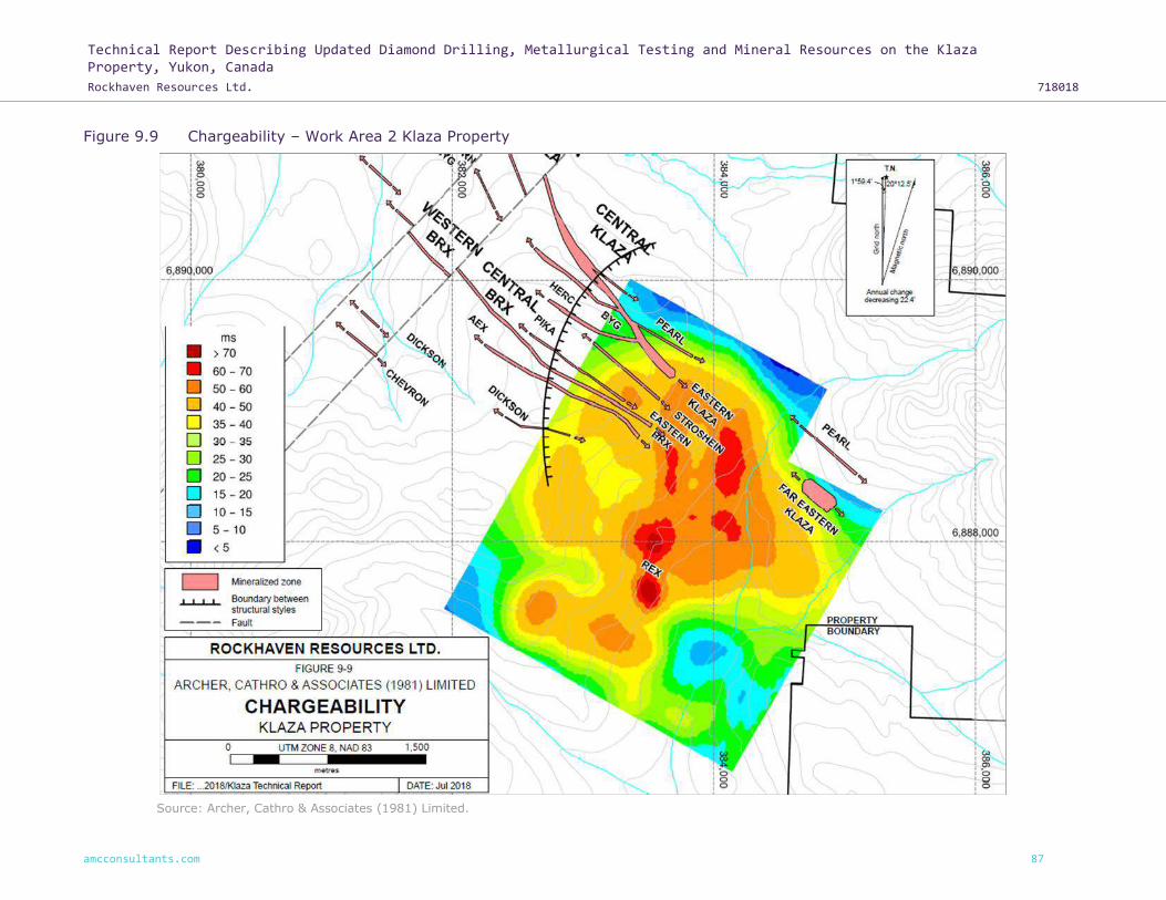
Technical Report Describing Updated Diamond Drilling, Metallurgical Testing and Mineral Resources on the Klaza Property, Yukon, Canada
Rockhaven Resources Ltd. 718018
amcconsultants.com 87
Figure 9.9 Chargeability – Work Area 2 Klaza Property
Source: Archer, Cathro & Associates (1981) Limited.

Technical Report Describing Updated Diamond Drilling, Metallurgical Testing and Mineral Resources on the Klaza Property, Yukon, Canada
Rockhaven Resources Ltd. 718018
amcconsultants.com 88
Figure 9.10 Resistivity – Work Area 2 Klaza Property
Source: Archer, Cathro & Associates (1981) Limited.

Technical Report Describing Updated Diamond Drilling, Metallurgical Testing and Mineral Resources on the Klaza Property, Yukon, Canada
Rockhaven Resources Ltd. 718018
amcconsultants.com 89
10 Drilling
The Mineral Resource estimation discussed in this report was determined using the data provided
by diamond drilling completed by Rockhaven between 2010 and 2017. It does not include any of
Rockhaven’s percussion drill results or any historical drill data. It also does not include assays from
trenching.
10.1 Diamond drilling summary
Between 2010 and 2017, a total of 94,448.71 m of exploration and definition drilling was done by
Rockhaven in 435 diamond drillholes on the Property. Figure 10.1 shows the location of all 435 of
the diamond drillholes.
The majority of diamond drillholes were collared at dips of -50° and had azimuths of 030° to 035°
(north-northeast) as shown on Figure 10.1. Drilling was completed on section lines spaced roughly
50 m apart along much of the lengths of both the Klaza and BRX zones.
Some of the 2015 drilling was done in part for geotechnical and environmental purposes. To monitor
seasonal water levels and frost variations, vibrating wireline piezometers were installed in four holes
and a thermistor was installed in one hole. Five diamond drillholes, totalling 308.76 m, were drilled
vertically, peripheral to the Mineral Resource areas, as water monitoring wells.
Core recovery was good, averaging 96%, excluding the top 10 m of the holes where core recovery
was poor. The holes from the 2010 to 2012 programs were mostly sampled top to bottom (about
99% of core was sampled), while only visually mineralized or altered intervals and adjacent
wallrocks were sampled in 2014 through 2017. No drilling was conducted in 2013.
Final drillhole depths within the Klaza zone averaged 217.28 m, which included a maximum drillhole
depth of 550.77 m. At the BRX zone, final drillhole depths averaged 213.32 m and reached a
maximum of 567.26 m. The number of holes and total metres drilled on the Property each year
between 2010 and 2017 are listed by zone in Table 10.1.
Table 10.1 2010 to 2017 diamond drilling summary
Target – year Holes drilled Total drilled (m)
Klaza zone – 2010 7 1,035.10
BRX zone – 2010 4 606.99
Klaza zone – 2011 39 11,211.85
BRX zone – 2011 9 1,717.25
Klaza zone – 2012 27 8,351.38
BRX zone – 2012 31 9,652.55
Klaza zone – 2014 34 6,709.97
BRX zone – 2014 58 10,140.73
Klaza zone – 2015 28 6,495.91
BRX zone – 2015 22 6,541.01
Klaza zone – 2016 25 4,204.19
BRX zone – 2016 12 2,591.74
Klaza zone – 2017 49 7,404.31
BRX zone – 2017 35 5,227.05
Nearby exploration – 2011 - 2017 55 12,558.68
Note: nearby exploration includes all holes drilled outside the BRX and Klaza zones. Source: Archer, Cathro & Associates (1981) Limited.
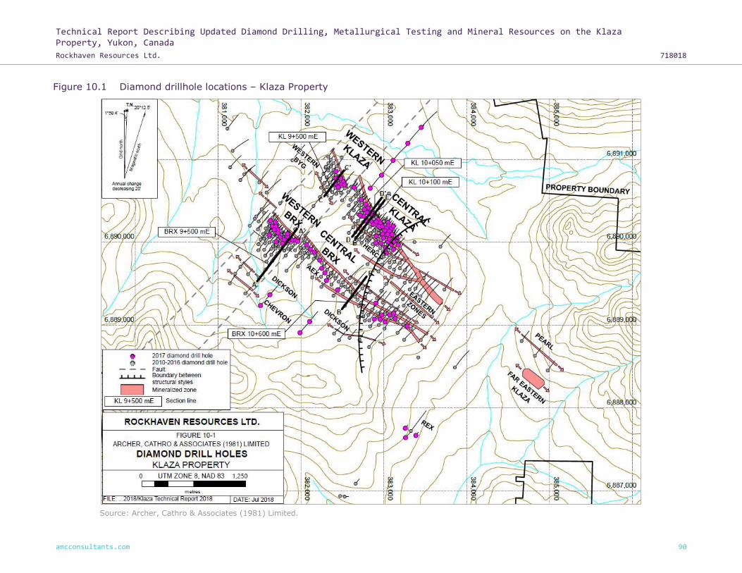
Technical Report Describing Updated Diamond Drilling, Metallurgical Testing and Mineral Resources on the Klaza Property, Yukon, Canada
Rockhaven Resources Ltd. 718018
amcconsultants.com 90
Figure 10.1 Diamond drillhole locations – Klaza Property
Source: Archer, Cathro & Associates (1981) Limited.

Technical Report Describing Updated Diamond Drilling, Metallurgical Testing and Mineral Resources on the Klaza Property, Yukon, Canada
Rockhaven Resources Ltd. 718018
amcconsultants.com 91
Table 10.2 shows the drill confirmed strike length of each of the main zones and the maximum
down-dip intersection depth in each zone.
Table 10.2 Data for main mineralized zones
Zone Mineralized strike length (m) Maximum down-dip drill intersection (m)
Western Klaza 400 250
Central Klaza 800 325
Eastern Klaza 1,100 180
Western BRX 500 520
Central BRX 950 400
Eastern BRX 950 275
Pika 740 250
AEX 1,650 310
BYG 650 150
Dickson 450 100
HERC 460 310
Chevron 250 90
Pearl 450 100
Source: Archer, Cathro & Associates (1981) Limited.
All of the mineralized zones listed above begin at surface and are open to expansion along strike
and to depth.
Although significant drill intersections have been obtained from all of the main mineralized zones,
the focus of the most recent exploration has been the discrete high-grade veins within the BRX and
Klaza zones. For the purposes of deposit modelling and Mineral Resource estimation, the BRX and
Klaza zones have been subdivided as follows:
• BRX zone – Central BRX, and Western BRX zones.
• Klaza zone – Central Klaza, and Western Klaza zones.
The BRX zone has been traced for approximately 2,400 m along strike and been tested to a
maximum depth of 520 m down-dip. Mineralization is associated with a laterally extensive northwest
striking and moderately to steeply southwest dipping feldspar porphyry dyke. Veins occur on the
margins of that dyke and, where the dyke bifurcates, the number of veins increases, which
sometimes results in wider mineralized intervals.
The Western BRX zone consists of quartz veins and vein zones that contain pyrite, arsenopyrite,
galena, sphalerite, chalcopyrite and sulphosalts. Carbonate gangue facies in these veins largely
comprises manganiferous carbonates (rhodochrosite). Figure 10.2 illustrates the geometry of the
mineralization defining this zone.

Technical Report Describing Updated Diamond Drilling, Metallurgical Testing and Mineral Resources on the Klaza Property, Yukon, Canada
Rockhaven Resources Ltd. 718018
amcconsultants.com 92
Figure 10.2 Section 9+500 mE Western BRX zone – Klaza Property
Source: Archer, Cathro & Associates (1981) Limited.

Technical Report Describing Updated Diamond Drilling, Metallurgical Testing and Mineral Resources on the Klaza Property, Yukon, Canada
Rockhaven Resources Ltd. 718018
amcconsultants.com 93
One of the best intersections in the Western BRX zone came from KL-14-238, which intersected
multiple veins within an 18.5 m interval that averaged 2.19 g/t gold and 120 g/t silver. The best of
the veins in that interval graded 16.29 g/t gold and 1,435 g/t silver over 1.37 m. At 520 m down-dip,
this is the deepest intersection to date on the Property.
The Central BRX zone features veins and vein zones that are dominated by quartz, pyrite and
iron-rich carbonates such as ankerite and siderite. Pyrite, sphalerite and galena are the main
sulphide minerals, while arsenopyrite and sulphosalts are absent, or present in only minor
quantities. A type section depicting the geometry of the mineralized veining relative to the dyke is
shown in Figure 10.3.
The mineralogical differences between the Western BRX and Central BRX zones suggest some
degree of vertical off-set along a major cross-fault, which separates the two segments of the zone.
The Klaza zone is on a parallel trend about 800 m northeast of the BRX zone. Drillholes have tested
along the zone on section lines spaced approximately 50 m apart. The Klaza zone has been
subdivided into three subzones - Western Klaza zone, Central Klaza zone and Eastern Klaza zone.
The former two subzones are included in the Mineral Resource estimate and described below. The
Western and Central Klaza zones are off-set by the same cross-fault that separates the
corresponding sections of the BRX zone.
The Western Klaza zone is defined by two narrow high-grade silver-gold veins (extending west from
section KL 9+700). Unlike other zones, these veins are not emplaced alongside a feldspar porphyry
dyke and they are not flanked by the type of sheeted veining seen elsewhere in the Klaza zone. The
mineral assemblages in the Western Klaza zone contain higher proportions of arsenopyrite and
sulphosalts than are common further east in the Klaza zone, and silver to gold ratios are higher.
Mineralization in the Central Klaza zone (east of section KL 9+700 m and west of section KL
10+600 m) is hosted within a laterally extensive complex of steeply dipping veins, breccias and
sheeted veinlets, which are associated with a swarm of feldspar porphyry dykes. The strongest
veins are typically found along dyke margins. Pyrite, arsenopyrite, galena and sphalerite are the
main sulphide minerals in this subzone. The deepest hole at the Klaza zone, KL-12-133, intersected
strong mineralization over 6.70 m suggesting the zone is open at depth.
Type sections for the Western Klaza and Central Klaza zones are shown on Figure 10.4 and Figure
10.5, respectively.
Mineralization within the eastern portions of the BRX and Klaza zones comprises a series of closely
spaced, narrow, sub-parallel veins and vein zones dominated by quartz, pyrite and lesser
chalcopyrite. Unlike the Central and Western zones, sulphide mineralization in the Eastern zones
contains little arsenopyrite, galena, and sphalerite.
Exploration activities up to and including 2017 have assumed mineralization within the eastern
zones behaves similarly to the discrete high-grade veins in the central and western zones. The drill
spacing, and core sampling procedures used were designed for this style of target.
In early 2018, results from metallurgical testing on core collected in 2017 highlighted the low-grade
bulk tonnage potential of the eastern zones. The eastern zones were omitted from the 2018 Mineral
Resource estimate because gaps within the current sampling record and the drill spacing do not
adequately support a Mineral Resource estimate on this bulk tonnage target at this time.
The Qualified Person does not know of any drilling, sampling or recovery factors that could materially
impact the accuracy and reliability of the 2010 to 2017 results.

Technical Report Describing Updated Diamond Drilling, Metallurgical Testing and Mineral Resources on the Klaza Property, Yukon, Canada
Rockhaven Resources Ltd. 718018
amcconsultants.com 94
Figure 10.3 10+600 mE Central BRX zone – Klaza Property
Source: Archer, Cathro & Associates (1981) Limited.

Technical Report Describing Updated Diamond Drilling, Metallurgical Testing and Mineral Resources on the Klaza Property, Yukon, Canada
Rockhaven Resources Ltd. 718018
amcconsultants.com 95
Figure 10.4 Section 9+500 mE Western Klaza zone – Klaza Property
Source: Archer, Cathro & Associates (1981) Limited.

Technical Report Describing Updated Diamond Drilling, Metallurgical Testing and Mineral Resources on the Klaza Property, Yukon, Canada
Rockhaven Resources Ltd. 718018
amcconsultants.com 96
Figure 10.5 Section 10+050 mE Central Klaza zone – Klaza Property
Source: Archer, Cathro & Associates (1981) Limited.

Technical Report Describing Updated Diamond Drilling, Metallurgical Testing and Mineral Resources on the Klaza Property, Yukon, Canada
Rockhaven Resources Ltd. 718018
amcconsultants.com 97
10.2 Diamond drilling specifications
In 2010, diamond drilling on the Property was contracted to Top Rank Diamond Drilling Ltd. of Ste
Rose du Lac, Manitoba, and was done with two skid-mounted, diesel-powered JKS-300 drills using
NTW and BTW equipment.
In 2011, diamond drilling on the Property was contracted to three companies: Swiftsure Diamond
Drilling Ltd. of Nanaimo, British Columbia; Strike Diamond Drilling of Kelowna, British Columbia;
and, Elite Diamond Drilling of Vernon, British Columbia. The work was done using two skid-mounted,
diesel-powered A-5 drills and one skid-mounted, diesel-powered JKS-300 drill. The A-5 drills used
HQ equipment while the JKS-300 used BTW equipment.
In 2012, diamond drilling on the Property was contracted to four companies: Swiftsure Diamond
Drilling Ltd., Strike Diamond Drilling, Elite Diamond Drilling, and Platinum Diamond Drilling Inc. of
Winnipegosis, Manitoba. The work was done using three skid-mounted, diesel-powered A-5 drills
and one skid-mounted, diesel-powered JKS-300 drill. The A-5 drills used HQ and NQ equipment
while the JKS-300 used BTW equipment.
In 2014 through 2017, diamond drilling on the Property was contracted to Platinum Diamond Drilling
Inc. Most of the work was done using two skid-mounted, diesel-powered A-5 drills, with HQ and NQ
equipment. A skid-mounted, diesel-powered Discovery II diamond drill using NQ equipment was
also utilized in 2014.
10.3 Drill collar and down-hole surveys
All drillhole collars were surveyed by Archer Cathro employees using a Trimble SPS882 and SPS852
base and rover Real Time Kinematic (RTK) GPS system. The collars are marked by individual lengths
of drill rod that are securely placed into holes. A metal tag identifying the drillhole number is affixed
to each drillhole marker.
Most drill collars were aligned at surface using a Brunton compass. In 2014, a Reflex North Finder
APS, a GPS based compass, was used to align the later drillholes (KL-14-181 and higher). Beginning
in 2015, all drillholes were aligned using the APS tool.
To determine the deflection of each drillhole, the orientation was measured at various intervals
down the hole. In 2010 only, the dip was assessed by using an acid test taken at the bottom of the
hole, while holes completed in 2011 and 2012 were measured every 50 feet (ft) (15 m) using a
“Ranger Explorer” magnetic multi-shot tool provided by Ranger Survey Systems. Measurements
taken and recorded were azimuth, inclination, temperature, roll angle (gravity and magnetic) plus
magnetic intensity, magnetic dip and gravity intensity (for quality assurance). All readings were
reviewed, and erroneous data were not used when plotting the final drillhole traces.
Drillholes completed during the 2014 through 2017 programs were routinely surveyed every 50 ft
(15 m) using a Reflex EZ-Trac down-hole multi-shot magnetic survey instrument. At each survey
station, this instrument recorded the drillhole azimuth and inclination as well as the magnetic
intensity, temperature and other variables used for validating the readings.
Late in the 2014 season a manufacturing error with the magnetic sensors was discovered in one of
the down-hole survey instruments used in 35 holes. Once identified, the faulty instrument was
immediately replaced. To determine the orientation of the affected drillholes, data from reliable
surveys was plotted on a scatter plot showing the rate of change (°/m) against the down-hole
distance of the survey station. A best fit line was then passed through the data points and the
equation of this line determined. This equation approximates the deviation of the drillholes and was
used to calculate the deflection for the holes surveyed using the faulty instrument. These equations

Technical Report Describing Updated Diamond Drilling, Metallurgical Testing and Mineral Resources on the Klaza Property, Yukon, Canada
Rockhaven Resources Ltd. 718018
amcconsultants.com 98
are presented in the following table, where c is equal to the rate of change (°/m) and d the
down-hole distance.
Table 10.3 Downhole survey correction factor
HQ c=0.00006 x d + 0.0027
NQ2 c=0.00006 x d + 0.0062
Source: Archer, Cathro & Associates (1981) Limited.
To calculate the azimuth at a given depth, the rate of change was calculated for each station. This
was multiplied by the distance to the preceding station and added to the preceding azimuth. The
surface orientation as recorded either by compass or with the APS, if available, was used as the
initial azimuth at 0.00 m depth. The approximated azimuth values calculated using this equation for
the drillholes surveyed only with the faulty instrument were determined to be adequate for further
use and have been included in the drillhole database. While this approximation method is considered
reliable for shallow holes, it should only be used where no other data exists and not be used for
survey stations much beyond 300 m.
For a detailed description and validation of this calculation, please refer to the technical report
entitled “Geology, Mineralization, Geochemical Surveys, Geophysical Surveys, Diamond and
Percussion Drilling, Metallurgical Testing and Mineral Resources on the Klaza Property, Yukon,
Canada” dated 11 March 2015 and amended 19 June 2015 (Wengzynowski et al., 2015).
10.4 Oriented core surveys
A Reflex ACT III downhole digital core orientation system was used in 2014 and 2015 to orient the
core in a total of 46 holes.
In 2015, 18 of the 19 oriented drillholes were drilled using split tubes. The use of split tubes allowed
orientation measurements to be collected across incompetent intervals or intervals with poor
recovery.
Split tube intervals were oriented by Archer Cathro employees at the drill site. The core tube was
first aligned by the driller’s helper using the ACT III tool before the split tube was extracted from
the core tube. Care was taken to not shift the core during this process. A line representing the top
of the hole was marked down the length of the core by the Archer Cathro employees. Structural
orientation measurements within the interval were taken prior to the core being transferred to core
boxes.

Technical Report Describing Updated Diamond Drilling, Metallurgical Testing and Mineral Resources on the Klaza Property, Yukon, Canada
Rockhaven Resources Ltd. 718018
amcconsultants.com 99
11 Sample preparation, analyses, and security
11.1 Introduction
This section describes the sampling methods, sample shipment and security, analytical techniques,
QA / QC and data validation, followed during the 2010 to 2017 exploration programs. All exploration
programs were supervised by Archer Cathro on behalf of Rockhaven.
Results of work completed during 2016 and 2017 are discussed in detail in this report. Results from
2010 – 2015 were discussed by AMC previously in “Technical Report and PEA for the Klaza Au-Ag
Deposit, Yukon, Canada for Rockhaven Resources Ltd.”, dated 26 February 2016.
The Qualified Person is satisfied that the exploration approach and sample data from 2010 – 2017
are of sufficient quality for inclusion in resource evaluation studies. This data has been used for the
Mineral Resource Estimation described in Section 14 of this report.
11.2 Sampling methods
11.2.1 Soil sampling methods
Soil sampling was conducted on the Property between 2010 and 2017. In the deposit area, grid soil
samples were collected at 50 m intervals on lines spaced 100 m apart and oriented at 037°. All soil
sample locations were recorded using hand-held GPS units. Sample sites were marked by aluminum
tags inscribed with the sample numbers and affixed to 0.5 m wooden laths that were driven into
the ground. Soil samples were collected from 30 to 80 cm deep holes dug with hand-held augers.
They were placed into individually pre-numbered Kraft paper bags. Sampling was often hindered by
permafrost on moss-covered, north-facing slopes. Samples were not collected from some locations
due to poor sample quality.
11.2.2 Rock and trench sampling methods
All rock samples collected from the Klaza and BRX zones were taken from excavator trenches,
because there are no naturally outcropping exposures of these zones.
Continuous chip samples were collected from excavator trenches in several parts of the Property
during programs conducted between 2010 and 2017. The collection protocol for chip samples was
as follows:
1 Trenches were excavated.
2 The walls of trenches were cleaned, where necessary, with a shovel.
3 Trenches were mapped, and sample intervals marked at geological breaks or at 1 to 10 m
intervals depending on the intensity of alteration and mineralization.
4 Continuous chip samples were collected along one wall of the trench as close to the floor of
the trench as slumping would allow using a geological hammer. The chips were collected either
in a tub or on a sample sheet. Sample sizes averaged approximately 2.0 kilograms (kg) per
linear metre sampled for intervals containing veins and about 1.5 kg per linear metre sampled
for intervals comprised primarily of altered wallrock.
5 Samples were placed in doubled 6 mm plastic bags along with a pre-numbered sample tag,
then two or three samples were placed in a fiberglass bag sealed with a metal clasp and
sample numbers were written on the outside of that bag with permanent felt pen.
6 From 2011 to 2015, one blank and one Certified Reference Material (CRM standard) sample
were randomly inserted into every batch. No quality control samples were inserted into
batches in 2010.

Technical Report Describing Updated Diamond Drilling, Metallurgical Testing and Mineral Resources on the Klaza Property, Yukon, Canada
Rockhaven Resources Ltd. 718018
amcconsultants.com 100
7 In 2013, samples collected from trenches within the core of the BRX and Klaza zones were
divided into batches comprising 31 trench samples plus one blank sample, one assay standard
and one coarse reject duplicate sample.
11.2.3 Diamond drill core sampling methods
Geotechnical and geological logging was performed on all drill core from the 2010 to 2017 drill
programs. Prior to 2015, all logging data were recorded as a hardcopy during the day and
transcribed to digital format during the evenings. Beginning in 2015, drill logs were entered directly
into a digital database.
Drill core samples were collected using the following procedures:
1 Core was reassembled, lightly washed and measured.
2 Core was wet photographed.
3 Core was geotechnically logged.
4 Magnetic susceptibility measurements were taken at 1 m intervals along the core.
5 Core was geologically logged, and sample intervals were designated. Sample intervals were
set at geological boundaries, drill blocks, or sharp changes in sulphide content.
6 Core recovery was calculated for each sample interval.
7 From 2010 to 2011, visually promising core intervals were sawn in half using a rock saw and
the remainder of the core was split with an impact core splitter. In 2012, all visually promising
core intervals were sawn in half using a rock saw, while selected specimens of altered country
rock were split using an impact core splitter. From 2014 onwards, all marked samples were
cut using a rock saw. In each case, one half of the core was sampled, and the remaining half
was placed back in the core box.
8 All samples were double bagged in 6 mm plastic bags, a pre-numbered sample tag was placed
in each sample bag, then two or three samples were placed in a fiberglass bag sealed with a
metal clasp and sample numbers were written on the outside of that bag with permanent felt
pen. From 2012 onwards, the fibreglass bag was sealed with a numbered security tag.
9 Two blank and two assay standard samples were randomly included with every batch of 30
samples (prior to 2012, batches comprised 31 core samples).
10 One duplicate sample consisting of quarter-split core was included with every batch of 30
samples (prior to 2012, batches comprised 31 core samples).
11 Starting in 2012, one coarse reject duplicate sample was included with every batch of 30 core
samples.
A geotechnical log was filled out prior to geological logging of drill core and included the conversion
of drill marker blocks from imperial to metric plus determinations of core, rock quality designations
(RQD), hardness and weathering. From 2015 onwards, fracture frequency, joint sets, and joint set
roughness, shape and infill were also recorded.
Within oriented intervals, alpha and beta angles were recorded for each joint along with the
roughness, shape, and infill material and thickness.
A total of 172 point load measurements were taken on core in 2015 using an ELE International
digital point load test apparatus (Model 77-0115). Both axial and diametral measurements were
taken intermittently on all rock types except veins. The narrow nature of the veins and volume
requirements of the apparatus prohibited testing of the veins.

Technical Report Describing Updated Diamond Drilling, Metallurgical Testing and Mineral Resources on the Klaza Property, Yukon, Canada
Rockhaven Resources Ltd. 718018
amcconsultants.com 101
Density measurements were systematically taken on core, throughout each of the drill programs
except in 2010. A total of 2,644 density measurements were collected between 2011 and 2017 from
a variety of holes and lithologies. Measurements are mostly from vein, porphyry dyke, fresh
granodiorite and mineralized granodiorite, but also include aplite and mafic dyke material. Sample
densities were determined by cutting a 10 cm long section of core and then determining its weight
dry and its weight immersed in water. The data were then applied to the following formulas, as
applicable, to establish the density of each of these samples:
Density = weight in air ÷ [Pi x (diameter of core ÷ 2)2 x length of core]
For samples that could not be cut, a graduated cylinder (filled with water) was used to calculate the
volume of the core sample and in turn the sample’s density. Employing this technique, each sample
was first weighed in air, and then its displacement was calculated using a volumetric cylinder. A
second formula was then used to determine the density of each sample:
Density = weight in air ÷ (Final Volume – Initial Volume)
In addition to density, the specific gravity was calculated using the following formula for each sample
wherever possible.
Specific Gravity = weight in air ÷ (weight in air – weight in water)
Density calculated using the volumetric method is the preferred value. Where this is unavailable,
the calculated volume value is the second choice. Values derived from each of the three methods
were compared against each other. Any significant discrepancies between methods were
investigated and corrected. If no resolution was determined, the measurement was removed from
the database.
Note that density measurements ignore the potential impact of pore space. As the rock is generally
competent and contains minimal voids, the density measurements are considered to be a good
approximation of bulk density.
Only vein zones and associated peripheral alteration were sampled beginning in 2014. Care was
taken during all drill programs to ensure that the sample split was not biased to sulphide content
and, therefore, the sampling should be reliable and representative of the mineralization.
11.3 Sample shipment and security
In 2010, all drill core was trucked to the Archer Cathro yard in Whitehorse for logging and splitting.
Between 2011 and 2017, drill core was logged and sawn or split at a processing facility on the
Property. Chip samples taken between 2010 and 2017 were collected and labelled at the trenches
on the Property.
In 2010, Archer Cathro personnel were responsible for transporting all samples from Archer Cathro’s
Whitehorse yard to ALS Minerals’ Whitehorse preparation facility. Between 2011 and 2017, Archer
Cathro personnel were responsible for transporting all samples from the Property by truck to ALS
Minerals’ facility in Whitehorse for preparation. ALS Minerals was responsible for shipping the
prepared sample splits from Whitehorse to its North Vancouver laboratory, where they were
analyzed. All samples were controlled by employees of Archer Cathro until they were delivered
directly to ALS Minerals in Whitehorse.
In 2012 through 2017, Archer Cathro ensured that a Chain of Custody form accompanied all batches
of drill core during transportation from the Property to the preparation facility. A unique security
tag was attached to each individual fiberglass bag when the bag was sealed. The bags and security
tags had to be intact in order to be delivered to ALS Minerals. If a security tag or bag arrived at the

Technical Report Describing Updated Diamond Drilling, Metallurgical Testing and Mineral Resources on the Klaza Property, Yukon, Canada
Rockhaven Resources Ltd. 718018
amcconsultants.com 102
laboratory damaged, an investigation into the transportation and handling of that sample bag was
undertaken by ALS Minerals and Archer Cathro and any affected samples were not processed until
a resolution was reached regarding the security of the samples.
Prior to shipping, each individual sample was weighed. These weights were compared to weights
recorded by ALS Minerals upon receiving the samples. Any discrepancies between the two weights
were investigated.
11.4 Sample preparation and analysis
All samples were sent to ALS Minerals’ laboratory in Whitehorse for preparation and then on to its
laboratory in North Vancouver for analysis. ALS Minerals, a wholly owned subsidiary of ALS Limited,
is an independent commercial laboratory specializing in analytical geochemistry services. Both ALS
Minerals’ Whitehorse and North Vancouver laboratories meet requirements of International
Standards ISO/EC 17025:2017.
All soil samples were dried and screened to -180 microns. All rock, core and trench samples were
dried, fine crushed to better than 70% passing -2 mm and then a 250 g split was pulverized to
better than 85% passing 75 microns. Between 2014 and 2017, visually mineralized intervals and
adjoining samples were prepared using a technique designed for samples where coarse gold and
silver could be present. Using this technique, the sample is first dried and crushed to better than
90% passing 2 mm, then a 1,000 g split is taken and pulverized to better than 95% passing
106 microns.
In 2010 and 2011, all core and trench samples were initially analyzed for gold by fire assay followed
by atomic absorption spectrometry (Au-AA24) and 35 other elements by inductively coupled
plasma-atomic emission spectrometry (ME-ICP41). Over limit values for gold were determined by
fire assay and gravimetric finish (Au-GRA22) and silver values were determined using inductively
coupled plasma-atomic emission spectrometry (Ag-OG46). Sample pulps from mineralized intervals
of drill core from 2011 were later reanalyzed for lead and zinc as well as 46 other elements using
four acid digestion followed by inductively coupled plasma-atomic emission spectrometry and mass
spectrometry (ME-MS61). Over limit values for silver, lead and zinc were determined by inductively
coupled plasma-atomic emission spectrometry (Ag / Pb / Zn-OG62).
Beginning in 2012, all core and trench samples were routinely analyzed for gold by fire assay
followed by atomic absorption spectrometry (Au-AA24) and 48 other elements by four acid digestion
(ME-MS61). All over limit values were determined for gold by fire assay and gravimetric finish
(Au-GRA22), and for silver, copper, lead, and zinc by inductively coupled plasma-atomic emission
spectrometry (Ag / Cu / Pb / Zn-OG62).
Soil samples collected in 2010 were analyzed for gold by fire assay with inductively coupled
plasma-atomic emission spectrometry finish (Au-ICP21) and for 35 other elements using aqua regia
digestion and inductively coupled plasma-atomic emission spectrometry. Soil samples collected
between 2011 and 2017, were analyzed for gold by fire assay fusion and atomic absorption
spectrometry (Au-AA24) and for 35 other elements using aqua regia digestion and inductively
coupled plasma-atomic emission spectrometry.
11.5 Quality Assurance and Quality Control
For all of its exploration programs, Rockhaven routinely inserted CRMs, blanks and duplicates into
each batch. In the 2010 and 2011 drill programs, commercially available assay CRM samples for
gold and silver were purchased. Six project specific assay CRMs were prepared from coarse reject
material from the 2011 and 2012 core samples for use during the 2012 through 2017 programs.
These assay standards were prepared, homogenized and packaged by CDN Resource Laboratories

Technical Report Describing Updated Diamond Drilling, Metallurgical Testing and Mineral Resources on the Klaza Property, Yukon, Canada
Rockhaven Resources Ltd. 718018
amcconsultants.com 103
Ltd. of Delta, British Columbia. All assay CRMs were certified by Smee & Associates Consulting Ltd.
of North Vancouver, British Columbia.
Starting in 2012 batches comprised 30 samples. Two CRMs and blanks were inserted into the sample
sequence in each batch. CRMs were placed randomly, while blanks were placed following visually
mineralized intervals where possible. One quarter-core duplicate was also inserted into each batch
at random locations chosen by the geologist while logging. From 2012 forward, one sample in each
batch was selected at random by the geologist and recorded on the sample submittal form as a
coarse duplicate, instructing the preparation laboratory to collect a second sample following
crushing. This coarse duplicate was processed and analyzed at the same time as the rest of the
batch. Prior to 2012, batches comprised 31 samples, and did not include coarse reject duplicates.
The following table summarizes the number of QA / QC samples analyzed each year by Rockhaven.
No drilling was conducted in 2013.
Table 11.1 QA / QC samples by year
Year All samples Core
samples CRMs
(standards) Blanks
Quarter-core duplicates
Coarse reject duplicates
2010 867 746 49 50 22 0
2011 7,469 6,419 423 422 205 0
2012 13,663 11,359 760 789 373 382
2013 0 0 0 0 0 0
2014 7,450 6,201 415 416 195 223
2015 4,998 4,166 277 277 132 146
2016 3,844 3,202 213 216 100 113
2017 5,954 4,959 331 331 157 176
Total 44,245 37,052 2,468 2,501 1,184 1,040
Note: No drilling was conducted in 2013. Coarse reject duplicates, as defined in this report, are a second pulp prepared from the same coarse reject material as the main sample. Source: Compiled by AMC Mining Consultants (Canada) Ltd. from data provided by Archer Cathro.
Results from the QA / QC program were reviewed immediately upon receipt of the assay certificate
and on a regular basis to identify potential biases.
Following core processing, individual samples were segregated based on a visual geological
assessment of mineralization into samples appearing to be mineralized and those appearing un-
mineralized. Samples were then packaged accordingly into separate batches for dispatch to the
laboratory. Mineralized samples were prepared using a different preparation technique, appropriate
for coarse gold and silver as described in Section 11.4. A second coarse reject duplicate was
requested for visually mineralized batches in place of a quarter-core duplicate to preserve core and
enable further studies (i.e. metallurgy) on mineralized intervals.
Rockhaven’s 2016 – 2017 quality assurance / quality control (QA / QC) program comprised
9,798 samples. This comprised 8,161 core samples, 544 CRMs, 547 blanks, 257 quarter-core
duplicates, and 289 coarse reject duplicates.
11.5.1 Assay results of Certified Reference Materials
A total of seven different CRMs was used during Rockhaven’s 2016-2017 program. Six of these
CRMs were prepared by CDN Resource Laboratories from coarse reject material taken from
Rockhaven’s 2012 drill program. One higher-grade CRM was obtained from CDN Resource
Laboratories commercial inventory.

Technical Report Describing Updated Diamond Drilling, Metallurgical Testing and Mineral Resources on the Klaza Property, Yukon, Canada
Rockhaven Resources Ltd. 718018
amcconsultants.com 104
The CRMs contain standard, predetermined quantities of gold, silver, lead, zinc, and copper which
are all monitored in Rockhaven’s QA / QC process. Since gold has the greatest impact on potential
value, the following tables and figures focus on the gold assays.
Table 11.2 tabulates the CRMs used for the 2016 and 2017 programs and the expected values.
Table 11.2 Recommended values of Certified Reference Materials
CRM Au (g/t) Standard deviation
Ag (g/t) Standard deviation
Pb (%) Standard deviation
Zn (%) Standard deviation
KL1 4.46 0.155 119.8 2.15 0.960 0.026 1.590 0.04
KL2 2.23 0.08 25.3 1.05 0.283 0.008 0.544 0.018
KL3 0.766 0.036 9.49 0.475 0.136 0.005 0.300 0.006
KL4 0.355 0.02 4.6 0.35 0.049 0.001 0.087 0.004
KL5 0.880 0.036 11.9 0.55 0.128 0.005 0.236 0.010
KL6 1.72 0.067 38.9 1.05 0.166 0.004 0.332 0.017
CDN-ME-1402 13.9 0.4 131 3.5 2.48 0.055 15.23 0.335
Source: Compiled by AMC Mining Consultants (Canada) Ltd. from data provided by Archer Cathro.
CRMs are inserted to check the analytical accuracy of the laboratory. AMC advocates an insertion
rate of at least 5% of the total samples analyzed. AMC notes that the CRMs used show a range of
values for each economic mineral to monitor analytical accuracy at various metal levels. This is
appropriate given the two sample streams that Rockhaven employs.
CRM performance is typically monitored using control charts. The performance of the CRMs is
measured against the standard deviation (SD) values that are provided with the CRMs. AMC
advocates re-assaying assay batches with two consecutive CRMs occurring outside two standard
deviations, or one CRM occurring outside three standard deviations.
Rockhaven has provided data for CRMs used during the 2016 and 2017 programs. Rockhaven’s
CRMs represent over 5% of the total samples assayed. Rockhaven runs two separate sample
streams based on visual indications of mineralization and has selected CRMs that cover a range of
grades within the typical sample population in each respective sample stream.
Rockhaven monitors CRMs immediately upon receipt of assays. Where a CRM fails (returns a result
±3 times the SD from the expected value), or there are two consecutive warnings (±2 times the
SD from the expected value), the assay batch is re-run.
Table 11.3 shows a summary of the CRM assay results from the 2016 and 2017 programs for gold.

Technical Report Describing Updated Diamond Drilling, Metallurgical Testing and Mineral Resources on the Klaza Property, Yukon, Canada
Rockhaven Resources Ltd. 718018
amcconsultants.com 105
Table 11.3 2016 – 2017 Assay results of CRMs for gold
CRM Expected Au value (g/t)
No. of assays Warnings (±2
SD) Fails (± 3 SD)
Sample switch
True fails
KL1 4.46 54 0 0 0 0
KL2 2.23 32 2 2 0 2
KL3 0.766 74 2 1 0 1
KL4 0.355 101 4 1 0 1
KL5 0.88 121 6 2 1 1
KL6 1.72 148 11 2 0 2
CDN-ME-1402 13.9 14 0 1 0 1
Total - 544 25 9 1 8
Note: A sample switch is when the geologist has inserted a CRM into the sample bag, different from what he / she recorded on the sample sheet. Source: Compiled by AMC Mining Consultants (Canada) Ltd. from data provided by Archer Cathro.
Figure 11.1 and Figure 11.2 show the results of 54 assays on CRM KL1 and 121 assays on CRM KL5.
Figure 11.1 Control chart for 2016 – 2017 KL1
Note: Warning limit is outside two standard deviations. Failure limit is outside three standard deviations. Source: Compiled by AMC Mining Consultants (Canada) Ltd. from data provided by Archer Cathro.

Technical Report Describing Updated Diamond Drilling, Metallurgical Testing and Mineral Resources on the Klaza Property, Yukon, Canada
Rockhaven Resources Ltd. 718018
amcconsultants.com 106
Figure 11.2 Control chart for 2016 – 2017 KL5
Note: Warning limit is outside two standard deviations. Failure limit is outside three standard deviations. Source: Compiled by AMC Mining Consultants (Canada) Ltd. from data provided by Archer Cathro.
AMC considers the CRMs chosen by Rockhaven to be appropriate to monitor laboratory accuracy
within the respective sample streams at this stage of project development.
Rockhaven monitors CRM performance on a batch by batch basis and addresses batch issues using
procedures that match industry standards.
11.5.2 Assay results of blank samples
Coarse blanks test for contamination during both the sample preparation and assay process. In
AMC’s opinion, the “pass mark” requirement for blanks is that 80% of coarse blank assays should
be less than twice the detection limit for that element.
Rockhaven routinely inserts two blanks into each batch sent to the laboratory. Blanks are prepared
from commercially available marble and are kept in bags in the core shack, away from any possible
sources of contamination. Blank samples are prepared in advance and are weighed to ensure the
total mass of each blank is close to the average mass of samples submitted.
A total of 547 blank samples were inserted into the sample sequence during Rockhaven’s
2016 – 2017 programs. A total of 20 blank samples returned values gold values greater than two
times the detection limit. When a blank fails, new pulps are prepared for the whole batch and the
whole batch is re-assayed.
As 96% of the coarse blanks assays were less than twice the detection limit for gold, AMC considers
the assay results of the blank materials to be acceptable.
11.5.3 Assay results of duplicates
Coarse, uncrushed duplicate samples monitor sampling variance (including that arising from
crushing), analytical variance and geological variance.

Technical Report Describing Updated Diamond Drilling, Metallurgical Testing and Mineral Resources on the Klaza Property, Yukon, Canada
Rockhaven Resources Ltd. 718018
amcconsultants.com 107
In AMC's opinion, duplicates should constitute around 5% of the samples submitted to the
laboratory. Unmineralized samples should not be sent as duplicates because assays near the
detection limit are commonly inaccurate.
Duplicate data can be viewed on a scatterplot but should also be compared using the relative paired
difference (RPD) plot. This method measures the absolute difference between a sample and its
duplicate. It is desirable to achieve 80 to 85% of the pairs having less than 20% RPD between the
original assay and check assay if it is a coarse duplicate (Stoker, 2006). Sample pairs should be
excluded from the analysis if the combined mean of the pair is less than 15 times the detection limit
(Kaufman and Stoker, 2009). Removing the low values ensures that there is no undue influence on
the RPD plots due to the higher variance of grades likely near to the detection limit, where precision
becomes poorer (Long et al., 1997).
In 2016 and 2017 drill programs, Rockhaven collected 289 coarse reject duplicates and
257 quarter-core (field) duplicates to test for repeatability. These samples were not based solely on
gold assay results. As a result, only 110 coarse reject duplicates and 45 field duplicates were greater
than the 15 times detection limit. RPD plots are presented in Figure 11.3 for the coarse reject
duplicate dataset.
AMC makes the following observations based on the coarse reject duplicate results:
• 75% of the coarse reject duplicate pairs were less than 20% RPD, which, though less than
desirable, is an acceptable result.
• No significant bias is observed between the original and duplicate assays.
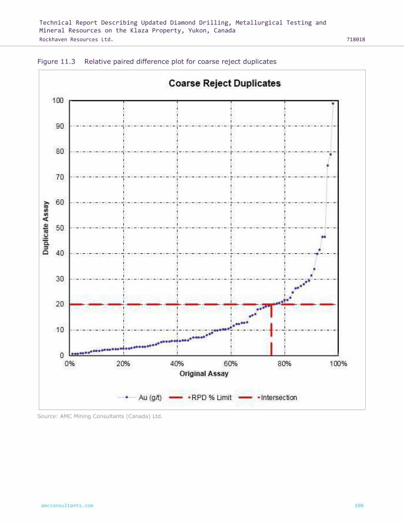
Technical Report Describing Updated Diamond Drilling, Metallurgical Testing and Mineral Resources on the Klaza Property, Yukon, Canada
Rockhaven Resources Ltd. 718018
amcconsultants.com 108
Figure 11.3 Relative paired difference plot for coarse reject duplicates
Source: AMC Mining Consultants (Canada) Ltd.

Technical Report Describing Updated Diamond Drilling, Metallurgical Testing and Mineral Resources on the Klaza Property, Yukon, Canada
Rockhaven Resources Ltd. 718018
amcconsultants.com 109
RPD plots are presented in Figure 11.4 for the field duplicate datasets.
AMC makes the following observations based on the field duplicate results:
• 46% of the field duplicate pairs were less than 20% RPD, which, is understandable given the
inherent variability in field duplicate sampling in gold systems.
• No significant bias is observed between the original and duplicate assays.
• Given the limited number of samples (< 100) that were > 15 x detection limit for the field
duplicates, no conclusions can be drawn from the data.
Figure 11.4 Relative paired difference plot for field duplicates
Source: AMC Mining Consultants (Canada) Ltd.

Technical Report Describing Updated Diamond Drilling, Metallurgical Testing and Mineral Resources on the Klaza Property, Yukon, Canada
Rockhaven Resources Ltd. 718018
amcconsultants.com 110
AMC recommends that additional duplicate samples be taken from mineralized material to provide
sufficient data for future RPD analyses.
11.5.4 Results of external check assays
Umpire laboratory duplicates are pulp samples sent to a separate laboratory to assess the accuracy
of the primary laboratory (assuming the accuracy of the umpire laboratory). Umpire duplicates
measure analytical variance and pulp sub-sampling variance. Umpire duplicates should comprise
around 5% of assays.
A total of 140 core samples analyzed in 2015 by ALS Minerals were randomly selected for check
analysis. These samples represent approximately 3% of the samples analyzed in 2015. Pulp rejects
from these samples were submitted to SGS in Burnaby, BC to be analyzed for gold by fire assay
followed by atomic absorption (GE FAA313) and 33 elements by four acid digestion followed by
inductively coupled plasma-atomic emission spectrometry (GE ICP40B). SGS is an ISO certified
laboratory and is independent of Rockhaven.
Results from the SGS assays are consistent with the assays completed by ALS Minerals (Figure
11.5).
Figure 11.5 Scatterplot showing ALS Minerals versus SGS analysis in 2015
Source: AMC Mining Consultants (Canada) Ltd.
Rockhaven did not complete any umpire laboratory duplicate sample testing of drillhole samples
completed in 2016 and 2017.
AMC recommends that further umpire duplicate sampling be completed.

Technical Report Describing Updated Diamond Drilling, Metallurgical Testing and Mineral Resources on the Klaza Property, Yukon, Canada
Rockhaven Resources Ltd. 718018
amcconsultants.com 111
11.6 Data validation
M.R. Dumala, P.Eng., of Archer Cathro, has supervised the exploration programs at the Property
from 2013 through 2017. He has helped establish the data collection and quality control procedures
used since 2010. At the beginning of each field season, he has provided on-site training to field
personnel. During subsequent visits, he reviewed data collection procedures and inspected selected
drill intervals.
Over the duration of each field program, sample information, drillhole surveys, drill logs and other
collected data were forwarded to Mr Dumala on a daily basis. The data were reviewed, and
corrections immediately made if necessary. Any changes to the collection procedure were made or
additional training was provided as needed.
Drillhole locations, downhole surveys and mineral intersections were plotted as they became
available. These were inspected and compared to the existing geological model. Any discrepancies
identified were investigated further and addressed as needed. In addition to the QA / QC procedures
outlined in Section 11.5 above, assay data stored in the drill database were routinely spot checked
against the original ALS assay certificates.
Prior to commencing the updated Mineral Resource estimate in Fall 2015, geotechnical, geological,
sample, mineralization, and density logs were reviewed by two Archer Cathro employees operating
independently of each other. Intervals were checked for missing data, overlaps and data entry
errors. Spot checks were performed against original paper logs where available. Any erroneous data
were reported, and steps were taken to either correct the errors or remove the affected data from
further use. Data captured after 2015 was validated in real-time by Archer Cathro’s inhouse
database software as described in Section 11.6.1. Data is also reviewed in 3D and cross checked
against the most recent geological interpretation.
The following sub-sections provide details of Archer Cathro’s data validation procedures for data
collection primarily focusing on data associated with the diamond drilling.
11.6.1 Database verification
Prior to 2014, geological and geotechnical logging was initially recorded as a hardcopy and then
transcribed into MS Excel®. In 2014, logging was recorded as hardcopy and then entered into a
MS-SQL Server® database (the Database). Starting in 2015 drill logs were entered directly into the
Database. All of the pre-2014 data has been verified and transferred to the Database.
Algorithms within the database automatically check all data as it is entered to ensure accuracy and
consistency. These checks include interval checks that alert the user if overlapping or missing
intervals are detected. Alerts are also generated if a downhole depth has been entered that is
greater than the final hole depth. Drop-down menus and internal libraries ensure consistency
between users by requiring the use of pre-approved lithological units, minerals and other logging
codes.
11.6.2 Collar location verification
Prior to 2017, all drillhole collars were surveyed by Archer Cathro employees using a Trimble SPS882
and SPS852 base and rover Real Time Kinematic (RTK) GPS system. In 2017, drill collars were
surveyed using a Leica GS15 base and rover RTK GPS.
All drillhole collars were re-surveyed in 2017 using the Leica system and, where necessary, survey
data collected in previous years was corrected. It was found that the differences between surveys
increased as the distance from the base station increased. At the furthest point, approximately

Technical Report Describing Updated Diamond Drilling, Metallurgical Testing and Mineral Resources on the Klaza Property, Yukon, Canada
Rockhaven Resources Ltd. 718018
amcconsultants.com 112
1.75 km from the base station, the horizontal difference averaged approximately 6 m. Nearer to
the base station, the difference averaged approximately 1 – 2 m. Differences between the Leica
surveys and the earlier Trimble surveys are explained by inclusion of an updated scaling factor and
corrected geoid model.
Elevation data obtained during the RTK GPS survey were compared to elevation data calculated
from low level orthorectified photographs. Any discrepancies identified were investigated and
corrected, if possible. If no resolution to a discrepancy was immediately apparent, an additional RTK
GPS survey was conducted.
11.6.3 Down-hole orientation verification
Prior to 2011, no down-hole azimuth measurements were made, and dip deviations were measured
using an acid tube at the bottom of each hole. This practice did not follow industry standards, but
due to the limited number of holes (11), shallow depths (up to 273.12 m) and good ground
conditions, this is not considered to be a significant issue.
Original survey data collected between 2011 and 2017 were obtained from the down-hole survey
tools in CSV format and imported directly into the Database. Data were visually inspected, and
erroneous data were not used during the interpretation process.
11.6.4 Assay verification
Digital assay certificates, for all of the drilling completed between 2010 and 2017, were obtained
from ALS Minerals in CSV format and imported directly into the Database.
Internal algorithms built into the Database ensure that the correct assay data were matched with
the correct sampling data. Errors detected by the Database were inspected and corrected. Spot
checking of data within the Database against hard copy certificates issued by ALS Minerals was also
implemented and did not reveal any issues.
11.7 Conclusions
In the opinion of the QP, the sampling, sample preparation, security, and analytical procedures
adopted by Rockhaven for its exploration programs meet accepted Industry standards. The QA / QC
results confirm that the assay results may be relied upon for Mineral Resource Estimation purposes.

Technical Report Describing Updated Diamond Drilling, Metallurgical Testing and Mineral Resources on the Klaza Property, Yukon, Canada
Rockhaven Resources Ltd. 718018
amcconsultants.com 113
12 Data verification
On 18 and 19 August 2015, full-time AMC employee Dr Adrienne Ann Ross, P. Geo., visited the
Property to undertake the following data verification steps:
Discussion with site personnel regarding:
• Sample collection
• Sample preparation
• Sample storage
• QA / QC
• Data validation procedures
• Survey procedures
• Geological interpretation
• Exploration strategy
Inspections of trenches, core shed, and drill core intersections were conducted. Table 12.1 lists the
inspected drillholes.
Table 12.1 Inspected drillholes
Zone Drillhole No.
Central BRX KL-14-196
Central Klaza KL-15-255
Central Klaza KL-15-270
Central Klaza KL-15-257
Central Klaza KL-11-050
Western BRX KL-14-192
Western BRX KL-15-291
Western Klaza KL-14-178
Western Klaza KL-14-182
Western Klaza KL-14-179
Source: AMC Mining Consultants (Canada) Ltd.
Dr Ross reviewed the processes used in the data collection and handling.
Under the supervision of Dr Ross, Mary Alejo, P.Eng of AMC undertook random cross-checks of 7%
of the 2015 assay results in the database with original assay results on the assay certificates
returned from ALS Laboratories and found no errors. Further details of this verification are described
in the NI 43-101 technical report titled “Technical Report and PEA for the Klaza Au-Ag Deposit,
Yukon Canada for Rockhaven Resources Ltd.” dated 26 February 2016.
Under the supervision of Dr Ross, Simeon Robinson, P.Geo. of AMC undertook random cross-checks
of assay results in the Rockhaven drillhole database provided by Archer Cathro with 2016 and 2017
assay certificates received directly from ALS.
Of the 9,798 samples sent to ALS for analysis in 2016 and 2017, 494 samples representing 5% of
the assay data were reviewed and assay results for Au, Ag, Pb, and Zn in the database were
compared to the original assay certificates.
Technical Report Describing Updated Diamond Drilling, Metallurgical Testing and Mineral Resources on the Klaza Property, Yukon, Canada
Rockhaven Resources Ltd. 718018
amcconsultants.com 114
No errors were detected between the drillhole database and assay certificates. This result was
anticipated as Archer Cathro has in-house software that automatically imports data from the lab
into the database.
AMC makes the following observations based on the data verification that was conducted in 2015
and from discussions on the work since:
• Site geologists are appropriately trained.
• Procedures for data collection and storage are well-established and adhered to.
• QA / QC procedures are adequate and give confidence in the assay results.
• Cross-checking a sample set of the database with the original assay results uncovered no
errors.
The QP considers the database fit-for-purpose and in the QP's opinion, the geological data provided
by Archer Cathro for the purposes of Mineral Resource estimation were collected in line with
industry best practice as defined in the CIM Exploration Best Practice Guidelines and the CIM
Mineral Resource, Mineral Reserve Best Practice Guidelines. As such, the data are suitable for use
in the estimation of Mineral Resources.

Technical Report Describing Updated Diamond Drilling, Metallurgical Testing and Mineral Resources on the Klaza Property, Yukon, Canada
Rockhaven Resources Ltd. 718018
amcconsultants.com 115
13 Mineral processing and metallurgical testing
This report focuses on metallurgical testwork conducted since 26 February 2016. For a detailed
account of the testing completed prior to 26 February 2016, please refer to the following technical
reports:
• “Geology, Mineralization, Geochemical Surveys, Geophysical Surveys, Diamond and
Percussion Drilling, Metallurgical Testing and Mineral Resources on the Klaza Property, Yukon,
Canada” dated 11 March 2015 and amended 19 June 2015 (Wengzynowski et al., 2015).
• “Technical Report and PEA for the Klaza Au-Ag Deposit, Yukon, Canada for Rockhaven
Resources Ltd.” (Ross et al, 2016), dated 26 February 2016.
Three of the metallurgical recommendations from the 2016 PEA were the development of a process
for Eastern BRX mineralized material, advancement of the pre-concentration concept for the project
and investigations into the production of higher grade refractory gold concentrates for possible sale
to third parties instead of on-site treatment.
Since publication of the PEA, progress has been made on each of these areas, with testing mostly
being conducted at Blue Coast Research Ltd (BCR).
Samples were provided by Rockhaven geologists from each of the zones as shown in Figure 13.1
below.
Figure 13.1 2017 metallurgical testing sample locations
Source: Archer, Cathro & Associates (1981) Limited.

Technical Report Describing Updated Diamond Drilling, Metallurgical Testing and Mineral Resources on the Klaza Property, Yukon, Canada
Rockhaven Resources Ltd. 718018
amcconsultants.com 116
13.1 Process development for Eastern BRX
13.1.1 Flotation testing
The sample provided to the laboratory for metallurgical testing assayed 2.06 g/t Au, 26 g/t Ag,
0.11% Pb, 0.12% Cu, and 0.26% Zn. Early testing showed that the copper / lead and zinc could be
placed quite efficiently into separate concentrates, but rougher concentrate grades were poor at a
3% combined copper and lead, and 2.5% zinc. These poor grades reflected the low copper, lead,
and zinc head grades in the tested sample. Cleaning the copper / lead rougher concentrate yielded
a concentrate assaying 15% Pb (copper was not assayed). This is likely still below saleable lead
grade, although the gold grade reached 330 g/t.
However, promising results have been obtained from cyanidation of the flotation products with the
aim of solely producing precious metal doré on site while processing Eastern BRX material. As gold
comprised 80% of the in-situ metal value in the composite, and silver another 11%, with good leach
metallurgy, the production of precious metal-bearing base metal concentrates becomes less
attractive, so this line of testing was curtailed. The pursuit of a flotation flowsheet to create one or
more of copper, lead, and zinc concentrates could be re-started should this become more attractive
in the future.
13.2 Cyanide leaching
The Eastern BRX composite was direct leached using 1 g/L sodium cyanide for 48 hours, yielding
81% gold and 34% silver extraction. Cyanide consumption was 2.3 kg/ton.
The composite was also floated to produce a high grade gold concentrate, gold cleaner tails sample
and a bulk sulphide composite. This approach was tested as it offered a way to process the Eastern
BRX material using, as much as possible, the same equipment as was scoped for the rest of the
project in the 2016 PEA study. The gold concentrate was intensively leached, and the bulk sulphide
concentrate was subjected to a fine regrind and then leached. The rougher flotation tail was not
leached. Floating these concentrates and subsequent leaching of the concentrates yielded 80% gold
and 36% silver extractions, based on the mill feed. Cyanide consumption equated to 1.4 kg/ton of
primary mill feed across the entire flowsheet.
Accordingly, the proposed simplified flowsheet for treatment of Eastern BRX material, arising from
this testwork is as shown in Figure 13.2 below. Nominally (subject to checking on equipment sizing),
all the equipment required for this process scheme would exist in the Klaza mill based on the
flowsheet as developed for the 2016 PEA study.
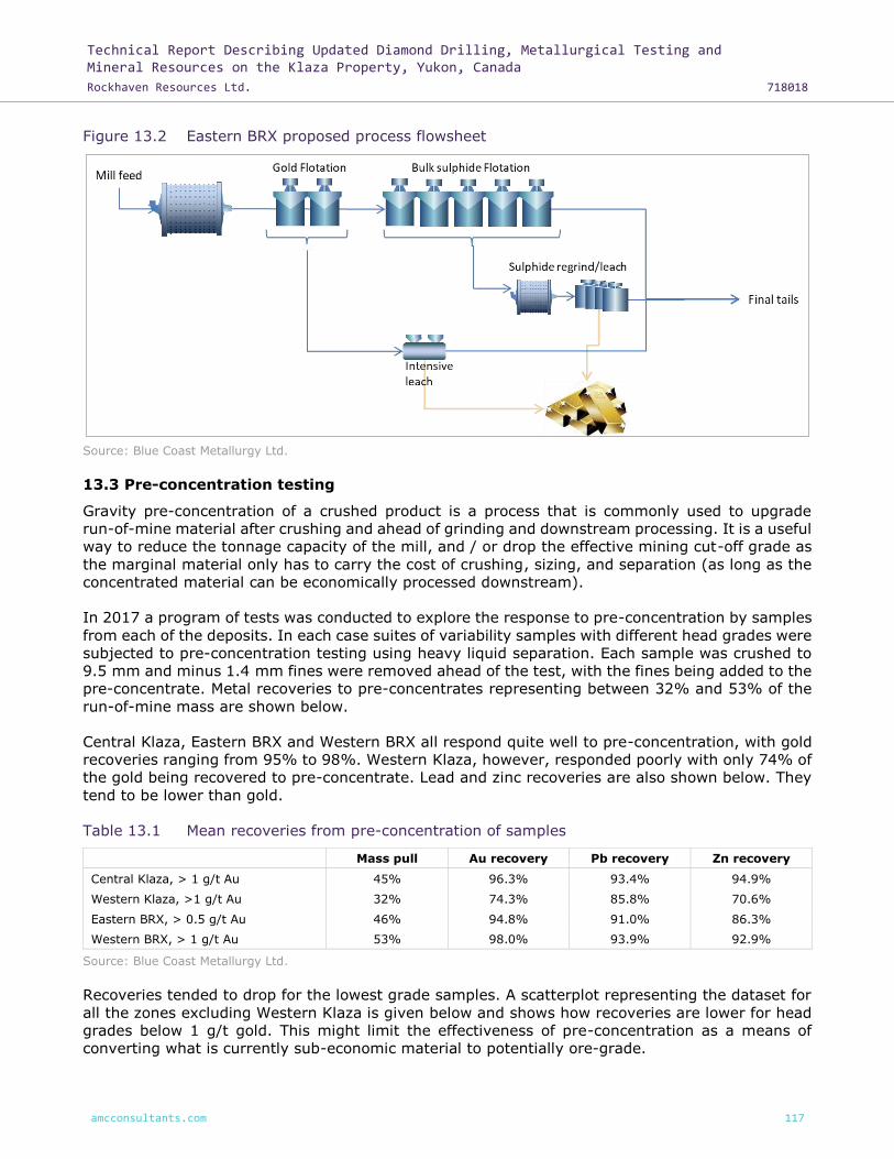
Technical Report Describing Updated Diamond Drilling, Metallurgical Testing and Mineral Resources on the Klaza Property, Yukon, Canada
Rockhaven Resources Ltd. 718018
amcconsultants.com 117
Figure 13.2 Eastern BRX proposed process flowsheet
Source: Blue Coast Metallurgy Ltd.
13.3 Pre-concentration testing
Gravity pre-concentration of a crushed product is a process that is commonly used to upgrade
run-of-mine material after crushing and ahead of grinding and downstream processing. It is a useful
way to reduce the tonnage capacity of the mill, and / or drop the effective mining cut-off grade as
the marginal material only has to carry the cost of crushing, sizing, and separation (as long as the
concentrated material can be economically processed downstream).
In 2017 a program of tests was conducted to explore the response to pre-concentration by samples
from each of the deposits. In each case suites of variability samples with different head grades were
subjected to pre-concentration testing using heavy liquid separation. Each sample was crushed to
9.5 mm and minus 1.4 mm fines were removed ahead of the test, with the fines being added to the
pre-concentrate. Metal recoveries to pre-concentrates representing between 32% and 53% of the
run-of-mine mass are shown below.
Central Klaza, Eastern BRX and Western BRX all respond quite well to pre-concentration, with gold
recoveries ranging from 95% to 98%. Western Klaza, however, responded poorly with only 74% of
the gold being recovered to pre-concentrate. Lead and zinc recoveries are also shown below. They
tend to be lower than gold.
Table 13.1 Mean recoveries from pre-concentration of samples
Mass pull Au recovery Pb recovery Zn recovery
Central Klaza, > 1 g/t Au 45% 96.3% 93.4% 94.9%
Western Klaza, >1 g/t Au 32% 74.3% 85.8% 70.6%
Eastern BRX, > 0.5 g/t Au 46% 94.8% 91.0% 86.3%
Western BRX, > 1 g/t Au 53% 98.0% 93.9% 92.9%
Source: Blue Coast Metallurgy Ltd.
Recoveries tended to drop for the lowest grade samples. A scatterplot representing the dataset for
all the zones excluding Western Klaza is given below and shows how recoveries are lower for head
grades below 1 g/t gold. This might limit the effectiveness of pre-concentration as a means of
converting what is currently sub-economic material to potentially ore-grade.
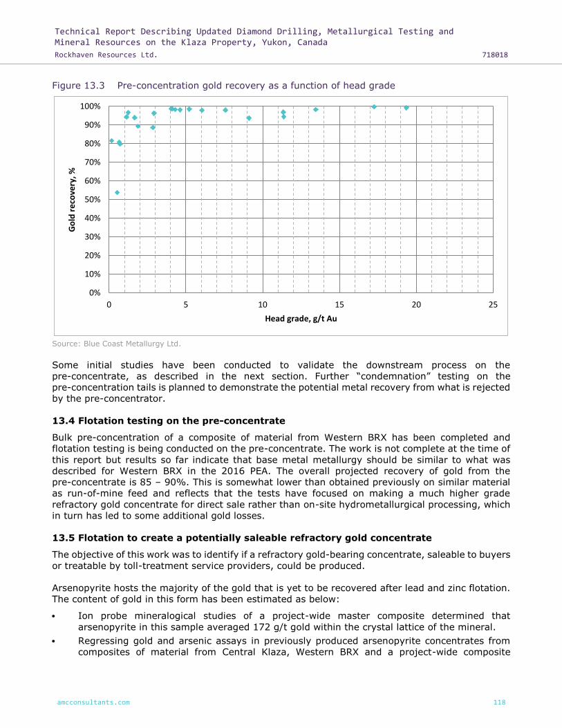
Technical Report Describing Updated Diamond Drilling, Metallurgical Testing and Mineral Resources on the Klaza Property, Yukon, Canada
Rockhaven Resources Ltd. 718018
amcconsultants.com 118
Figure 13.3 Pre-concentration gold recovery as a function of head grade
Source: Blue Coast Metallurgy Ltd.
Some initial studies have been conducted to validate the downstream process on the
pre-concentrate, as described in the next section. Further “condemnation” testing on the
pre-concentration tails is planned to demonstrate the potential metal recovery from what is rejected
by the pre-concentrator.
13.4 Flotation testing on the pre-concentrate
Bulk pre-concentration of a composite of material from Western BRX has been completed and
flotation testing is being conducted on the pre-concentrate. The work is not complete at the time of
this report but results so far indicate that base metal metallurgy should be similar to what was
described for Western BRX in the 2016 PEA. The overall projected recovery of gold from the
pre-concentrate is 85 – 90%. This is somewhat lower than obtained previously on similar material
as run-of-mine feed and reflects that the tests have focused on making a much higher grade
refractory gold concentrate for direct sale rather than on-site hydrometallurgical processing, which
in turn has led to some additional gold losses.
13.5 Flotation to create a potentially saleable refractory gold concentrate
The objective of this work was to identify if a refractory gold-bearing concentrate, saleable to buyers
or treatable by toll-treatment service providers, could be produced.
Arsenopyrite hosts the majority of the gold that is yet to be recovered after lead and zinc flotation.
The content of gold in this form has been estimated as below:
• Ion probe mineralogical studies of a project-wide master composite determined that
arsenopyrite in this sample averaged 172 g/t gold within the crystal lattice of the mineral.
• Regressing gold and arsenic assays in previously produced arsenopyrite concentrates from
composites of material from Central Klaza, Western BRX and a project-wide composite
0%
10%
20%
30%
40%
50%
60%
70%
80%
90%
100%
0 5 10 15 20 25
Go
ld r
eco
very
, %
Head grade, g/t Au
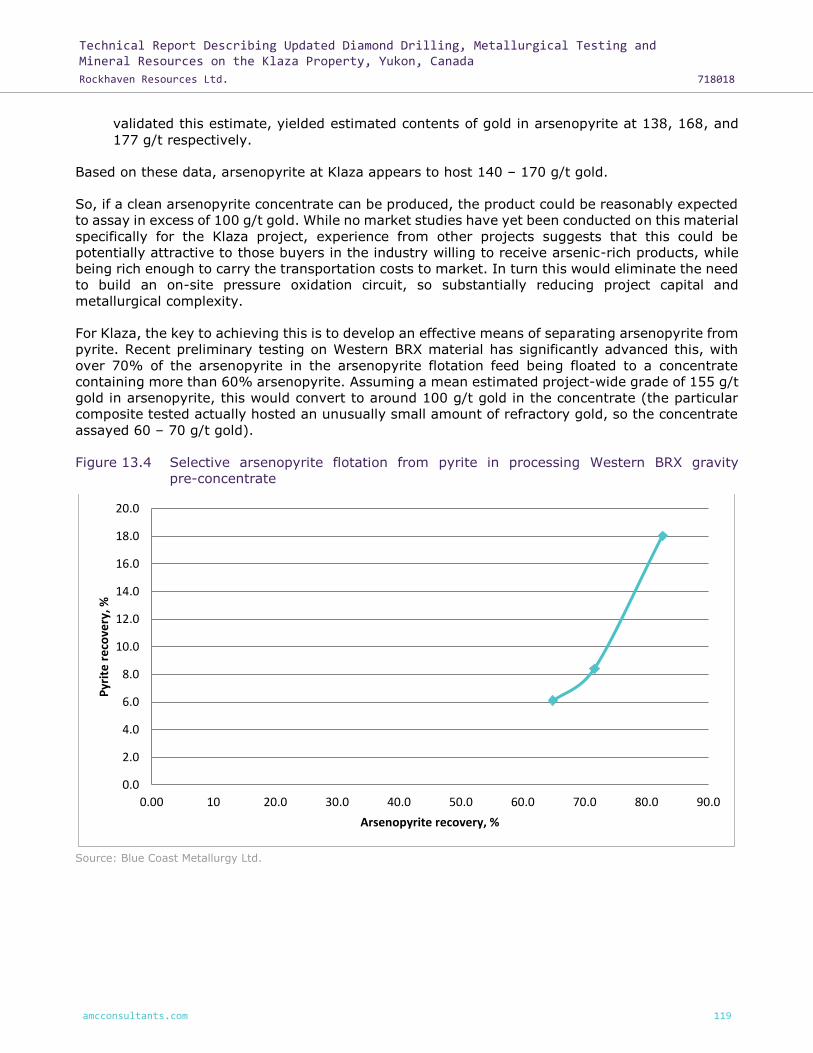
Technical Report Describing Updated Diamond Drilling, Metallurgical Testing and Mineral Resources on the Klaza Property, Yukon, Canada
Rockhaven Resources Ltd. 718018
amcconsultants.com 119
validated this estimate, yielded estimated contents of gold in arsenopyrite at 138, 168, and
177 g/t respectively.
Based on these data, arsenopyrite at Klaza appears to host 140 – 170 g/t gold.
So, if a clean arsenopyrite concentrate can be produced, the product could be reasonably expected
to assay in excess of 100 g/t gold. While no market studies have yet been conducted on this material
specifically for the Klaza project, experience from other projects suggests that this could be
potentially attractive to those buyers in the industry willing to receive arsenic-rich products, while
being rich enough to carry the transportation costs to market. In turn this would eliminate the need
to build an on-site pressure oxidation circuit, so substantially reducing project capital and
metallurgical complexity.
For Klaza, the key to achieving this is to develop an effective means of separating arsenopyrite from
pyrite. Recent preliminary testing on Western BRX material has significantly advanced this, with
over 70% of the arsenopyrite in the arsenopyrite flotation feed being floated to a concentrate
containing more than 60% arsenopyrite. Assuming a mean estimated project-wide grade of 155 g/t
gold in arsenopyrite, this would convert to around 100 g/t gold in the concentrate (the particular
composite tested actually hosted an unusually small amount of refractory gold, so the concentrate
assayed 60 – 70 g/t gold).
Figure 13.4 Selective arsenopyrite flotation from pyrite in processing Western BRX gravity
pre-concentrate
Source: Blue Coast Metallurgy Ltd.
0.0
2.0
4.0
6.0
8.0
10.0
12.0
14.0
16.0
18.0
20.0
0.00 10 20.0 30.0 40.0 50.0 60.0 70.0 80.0 90.0
Pyr
ite
re
cove
ry, %
Arsenopyrite recovery, %

Technical Report Describing Updated Diamond Drilling, Metallurgical Testing and Mineral Resources on the Klaza Property, Yukon, Canada
Rockhaven Resources Ltd. 718018
amcconsultants.com 120
14 Mineral Resource estimates
14.1 Introduction
The Mineral Resource for the Klaza deposit has been estimated by Dr A. Ross., P.Geo. Principal
Geologist of AMC Mining Consultants (Canada) Ltd. (AMC), who takes responsibility for the portions
of the model estimated by ordinary kriging (OK) and Mr Ingvar Kirchner, Principal Geologist of AMC
Mining Consultants Pty Ltd (Perth, Australia) who takes responsibility for the portions of the model
estimated by multiple indicator kriging (MIK), local multiple indicator kriging (LMIK), and restricted
ordinary kriging (ROK).
AMC is not aware of any known environmental, permitting, legal, title, taxation, socioeconomic,
marketing, political, or other similar factors that could materially affect the stated Mineral Resource
estimate.
This estimate is dated 5 June 2018 and supersedes the previous estimate outlined in the “Technical
Report and PEA of the Klaza Au-Ag Deposit, Yukon, Canada” with an effective date of
26 February 2016.
The data used in the 5 June 2018 estimate (AMC 2018 estimate) include results of all drilling carried
out on the Property to 31 December 2017. The estimation work was carried out in Datamine™
software. Grade interpolation was completed using a combination of OK, MIK, LMIK, and ROK. The
interpolation methodology utilized for each area is detailed in Table 14.1.
Table 14.1 Resource by area and estimation method
Zone Area Estimation method
BRX Western BRX OK
Central BRX OK
Klaza Western Klaza OK
Central Klaza OK, LMIK, MIK, and ROK
Source: AMC Mining Consultants (Canada) Ltd.
The results of the AMC 2018 estimate are summarized in Table 14.2 and expanded in Table 14.3.
Table 14.2 Summary of Mineral Resources as of 5 June 2018
Resource classification
Tonnes Grade Contained metal
Au Ag Pb Zn Au EQ Au Ag Pb Zn Au EQ
(Kt) (g/t) (g/t) (%) (%) (g/t) (koz) (koz) (klb) (klb) (koz)
Indicated 4,457 4.8 98 0.7 0.9 6.3 686 14,071 73,268 92,107 907
Inferred 5,714 2.8 76 0.6 0.7 3.9 507 13,901 77,544 89,176 725
Notes: CIM definition (2014) standards were used for the Mineral Resource. Estimate includes drill results to 31 December 2017. Near surface mineral resources are constrained by an optimized pit shell at metal prices of $1,400/oz, $19/oz Ag, $1.10/lb Pb, and $1.25/lb Zn. Cut-off grades applied to the pit-constrained and underground resources are 1.0 g/t AuEQ and 2.3 g/t AuEQ respectively. Gold equivalent values were calculated using parameters outlined in Table 14.4. Numbers may not add due to rounding. All metal prices are quoted in US$ at an exchange rate of US$0.80 to C$1.00. Mineral Resources that are not Mineral Reserves do not have demonstrated economic viability. Source: AMC Mining Consultants (Canada) Ltd.

Technical Report Describing Updated Diamond Drilling, Metallurgical Testing and Mineral Resources on the Klaza Property, Yukon, Canada
Rockhaven Resources Ltd. 718018
amcconsultants.com 121
Table 14.3 Summary of Mineral Resources as of 5 June 2018
Resource classification
Tonnes Grade Contained metal
Au Ag Pb Zn AuEQ Au Ag Pb Zn Au EQ
(Kt) (g/t) (g/t) (%) (%) (g/t) (Koz) (Koz) (Klbs) (Klbs) (Koz)
Indicated
Pit constrained 2,447 5.3 90 0.7 1.0 6.7 414 7,096 39,143 52,935 529
Underground 2,010 4.2 108 0.8 0.9 5.8 272 6,974 34,125 39,172 378
Indicated total 4,457 4.8 98 0.7 0.9 6.3 686 14,071 73,268 92,107 907
Inferred
Pit constrained 1,754 2.6 43 0.4 0.5 3.3 147 2,429 14,897 18,599 187
Underground 3,960 2.8 90 0.7 0.8 4.2 359 11,472 62,647 70,578 538
Inferred total 5,714 2.8 76 0.6 0.7 3.9 507 13,901 77,544 89,176 725
Notes: CIM definition (2014) standards were used for the Mineral Resource. Estimate includes drill results to 31 December 2017. Near surface mineral resources are constrained by an optimized pit shell at metal prices of $1,400/oz Au, $19/oz Ag, $1.10/lb Pb, and $1.25/lb Zn. Cut-off grades applied to the pit-constrained and underground resources are 1.0 g/t AuEQ and 2.3 g/t AuEQ respectively. Gold equivalent values were calculated using parameters outlined in Table 14.4. Numbers may not add due to rounding. All metal prices are quoted in US$ at an exchange rate of US$0.80 to C$1.00. Mineral resources that are not mineral reserves do not have demonstrated economic viability.
Source: AMC Mining Consultants (Canada) Ltd.
Table 14.4 Gold Equivalent (AuEQ) formula
Zone Au Recovery %
AuEQ (g/t) Au Ag Pb Zn
Central Klaza >1.0 g/t 92 86 79 81 AUEQ = 1 x AU + AG/94.40 + PB/3.38 + ZN/3.21
<1.0 g/t 78 76 73 71 AUEQ = 1 x AU + AG/90.56 + PB/3.10 + ZN/3.11
Western Klaza All 96 91 85 85 AUEQ = 1 x AU + AG/93.09 + PB/3.28 + ZN/3.20
Western BRX & Central BRX
>1.0 g/t 94 87 80 79 AUEQ = 1 x AU + AG/95.34 + PB/3.41 + ZN/3.37
<1.0 g/t 64 57 49 42 AUEQ = 1 x AU + AG/99.08 + PB/3.79 + ZN/4.31
Notes: AuEQ values assume metal prices of US$1,400/oz Au, US$19/oz Ag, US$1.10/lb Pb, and US$1.25/lb Zn and payable values of 97% Au, 81% Ag, 62% Pb, and 56% Pb.
14.1.1 Drillhole database
The data used in the AMC 2018 estimate consisted of surface diamond drillhole data held in a MS
SQL Server® database, which was provided to AMC as Microsoft Excel® files. The data type and
number of holes in the resource area are shown in Table 14.5.

Technical Report Describing Updated Diamond Drilling, Metallurgical Testing and Mineral Resources on the Klaza Property, Yukon, Canada
Rockhaven Resources Ltd. 718018
amcconsultants.com 122
Table 14.5 Drillhole data used in the Mineral Resource estimate
Year No. of drillholes No. of assays Metres drilled (m)
2010 6 447 961
2011 48 6,193 12,929
2012 42 6,813 13,462
2014 88 5,296 16,071
2015 40 3,416 10,955
2016 24 1,540 3,830
2017 74 3,561 10,741
Total 322 27,266 68,948
Note: All drillholes are surface diamond drillholes. Source: AMC Mining Consultants (Canada) Ltd.
14.1.2 Bulk density
The collection of density measurements is described in Section 11.2.3. Mineralized veins usually
contain significant concentrations of sulphide minerals, including pyrite and galena which have much
higher specific gravities than normal rock forming minerals. Examination of correlation coefficients
demonstrates a strong relationship between measured density and a sum of the base metal grades.
A scatterplots of density versus combined lead, zinc, copper, and iron assay values was produced
as shown in Figure 14.1.
Figure 14.1 Scatter plot of density versus percentage lead-zinc-copper-iron
Source: AMC Mining Consultants (Canada) Ltd.
y = 0.033x + 2.8449R² = 0.292
0
1
2
3
4
5
6
7
0 10 20 30 40 50 60 70
Den
sity
Pb+Zn+Cu+Fe %
Density vs Pb+Zn+Cu+Fe (%)

Technical Report Describing Updated Diamond Drilling, Metallurgical Testing and Mineral Resources on the Klaza Property, Yukon, Canada
Rockhaven Resources Ltd. 718018
amcconsultants.com 123
For this Mineral Resource estimate the mineralized portions of the block model were assigned a
density based on the combined estimated grades of lead, zinc, copper, and iron using the following
equation:
Density (t/m3) = 0.033 x (Pb%+Zn%+Cu%+Fe%) + 2.85
Barren rock, for the purpose of delineating a pit-constrained resource, was assigned a valued of
2.80 t/m3 (which approximates the average measured density of the granodiorite).
Note that density measurements ignore the potential impact of pore space. As the rock is generally
competent rock that contains minimal voids, the density measurements are considered to be a good
approximation of bulk density.
14.2 Ordinary kriging domaining and estimation parameters
14.2.1 Domain modelling OK
For the purpose of the Mineral Resource estimate, the Klaza deposit has two main zones, the BRX
and Klaza zones. These two zones are further subdivided into the Western BRX, Central BRX,
Western Klaza, and Central Klaza subzones (zones).
Matthew Dumala, P.Eng., of Archer, Cathro & Associates (1981) Limited, built 32 three dimensional
solids to constrain the mineralization within the BRX (Western and Central) zones and Klaza
(Western and Central). Mineralized solids define the better known and higher grade continuous
structures / veins. Dyke intersections were used as a marker to help constrain the orientation and
position of mineralized structures. In the previous estimate, as much as possible, high-grade solids
were built to capture only vein mineralization and often consisted of only one or two samples per
drillhole. In this estimate, the three-dimensional solids were wider and incorporated waste.
The number of mineralization domains varied between the subzones. There were 14 domains at
Western BRX and four domains at Central BRX. In the Klaza zone, Archer Cathro provided two
domains for the Western Klaza and 12 domains for Central Klaza. After reviewing the data, 7
domains in the Central Klaza that represented cross cutting structures were removed from the OK
estimation and included in the MIK-LMIK-ROK estimation.
Domains are summarized in Table 14.6.
Table 14.6 Domain nomenclature
Zone Area No. of domains for OK
BRX Western BRX 14
Central BRX 4
Klaza Western Klaza 2
Central Klaza 5
Source: AMC Mining Consultants (Canada) Ltd.
In total, 25 domains were used for the OK Mineral Resource estimate. On completion of the domain
modelling, visual checks were carried out to ensure that the constraining wireframes respected the
raw data.
Figure 14.2 shows the location of the zones in which the domains were modelled.

Technical Report Describing Updated Diamond Drilling, Metallurgical Testing and Mineral Resources on the Klaza Property, Yukon, Canada
Rockhaven Resources Ltd. 718018
amcconsultants.com 124
Figure 14.2 Zone locations with drillholes
Notes: Cross cutting structures in the Central Klaza area were estimated using MIK-LMIK-ROK estimation. All other areas were estimated by OK. Source: AMC Mining Consultants (Canada) Ltd.
Figure 14.3 shows an isometric view of the mineralized domains in Western BRX. It highlights the
local complexity of the Klaza deposit.
Figure 14.3 Isometric view of the Western BRX zone looking north east
Source: AMC Mining Consultants (Canada) Ltd.

Technical Report Describing Updated Diamond Drilling, Metallurgical Testing and Mineral Resources on the Klaza Property, Yukon, Canada
Rockhaven Resources Ltd. 718018
amcconsultants.com 125
14.2.2 Statistics and compositing OK
AMC selected a compositing interval of 1 m, which is the most common sample length in the
database. The second most common sample length is 3 m. As a result of this the median sample
length is 1.5 m. In some cases, compositing increased the number of samples in a domain. The 1 m
length also gave the appropriate selectivity for the narrow-vein style of this mineralization. Assays
within the wireframe domains were composited as close to 1 m intervals as possible which
approximates the mean sample length. Compositing started at the first mineralized wireframe
boundary from the collar and was reset at each new wireframe boundary.
Composited assay data for gold, silver, lead, zinc, copper, arsenic, and iron were then examined on
probability plots for each of the 25 domains, and outliers examined. This resulted in top cuts as
shown in Table 14.7. The main domains required little to no capping. It is important to note that in
some domains the upper limit of copper, iron, and arsenic was already defined by the upper
detection limit of the analytical method.
Table 14.7 Top cutting ranges by element
Element No. of domains with top cut % of domains with top cut Top cut range
Gold 9 36 1.5 - 60 g/t
Silver 8 32 15 - 700 g/t
Lead 9 36 0.2 – 7%
Zinc 8 32 0.7 – 4%
Copper 9 36 0.01 - 1%
Iron 5 20 10 - 30%
Arsenic 5 20 300 - 12,000 ppm
Notes: Copper and iron were estimated to provide a regression line for the density correlation. Arsenic was estimated for metallurgical assessment. Source: AMC Mining Consultants (Canada) Ltd.
Table 14.8 to Table 14.11 show the statistics of raw, composite and capped assay data from the
main mineralization domains for each zone.

Technical Report Describing Updated Diamond Drilling, Metallurgical Testing and Mineral Resources on the Klaza Property, Yukon, Canada
Rockhaven Resources Ltd. 718018
amcconsultants.com 126
Table 14.8 Statistics of raw, capped, and composite assay data – Western BRX
Raw
Element Au (g/t) Ag (g/t) Pb (%) Zn (%) As (ppm) Cu (% Fe (%)
Number 67 67 67 67 67 67 67
Minimum 0.00 0 0.00 0.01 18 0.00 2.72
Maximum 196.00 919 9.06 8.99 151500 2.02 33.20
Mean 10.90 126 0.82 1.22 14679 0.13 7.85
Std Dev 27.96 216.84 1.57 1.85 31174.41 0.30 6.11
Coeff Var 2.57 1.73 1.91 1.52 2.12 2.27 0.78
Composited
Element Au (g/t) Ag (g/t) Pb (%) Zn (%) As (ppm) Cu (% Fe (%)
Number 56 56 56 56 56 56 56
Minimum 0.01 0 0.00 0.01 18 0.00 2.98
Maximum 131.45 748 5.51 5.45 133500 1.70 29.10
Mean 10.90 126 0.82 1.22 14679 0.13 7.85
Std Dev 21.57 184.94 1.16 1.50 26111.81 0.25 4.97
Coeff Var 1.98 1.47 1.42 1.23 1.78 1.90 0.63
Capped
Element Au (g/t) Ag (g/t) Pb (%) Zn (%) As (ppm) Cu (% Fe (%)
Number 56 56 56 56 56 56 56
Minimum 0.01 0 0.00 0.01 18 0.00 2.98
Maximum 131.45 600 5.51 3.00 133500 1.70 29.10
Mean 10.90 122 0.82 1.02 14679 0.13 7.85
Std Dev 21.57 172.73 1.16 1.06 26111.81 0.25 4.97
Coeff Var 1.98 1.42 1.42 1.03 1.78 1.90 0.63
Notes: Std Dev = Standard Deviation; Coeff Var = Coefficient of Variation. All statistics are length-weighted. Statistics reported for Domain 5310 (wireframe WBRX01). Source: AMC Mining Consultants (Canada) Ltd.

Technical Report Describing Updated Diamond Drilling, Metallurgical Testing and Mineral Resources on the Klaza Property, Yukon, Canada
Rockhaven Resources Ltd. 718018
amcconsultants.com 127
Table 14.9 Statistics of raw, capped, and composite assay data – Central BRX
Raw
Element Au (g/t) Ag (g/t) Pb (%) Zn (%) As (ppm) Cu (% Fe (%)
Number 167 167 167 167 167 167 167
Minimum 0.00 0 0.00 0.00 16 0.00 2.15
Maximum 25.70 1600 12.20 18.10 51600 5.66 38.20
Mean 1.57 83 0.61 0.79 4084 0.11 8.04
Std Dev 2.76 158.75 1.40 1.72 7139.78 0.43 6.85
Coeff Var 1.76 1.92 2.29 2.18 1.75 3.83 0.85
Composited
Element Au (g/t) Ag (g/t) Pb (%) Zn (%) As (ppm) Cu (% Fe (%)
Number 168 168 168 168 168 168 168
Minimum 0.00 0 0.00 0.00 17 0.00 2.44
Maximum 13.05 978 10.10 8.78 32000 4.07 31.15
Mean 1.57 82 0.61 0.79 4075 0.11 8.02
Std Dev 2.16 131.53 1.16 1.28 5335.02 0.36 5.89
Coeff Var 1.37 1.60 1.91 1.62 1.31 3.20 0.73
Capped
Element Au (g/t) Ag (g/t) Pb (%) Zn (%) As (ppm) Cu (% Fe (%)
Number 168 168 168 168 168 168 168
Minimum 0.00 0 0.00 0.00 17 0.00 2.44
Maximum 13.05 700 10.10 8.78 32000 4.07 25.00
Mean 1.57 80 0.61 0.79 4075 0.11 7.94
Std Dev 2.16 120.33 1.16 1.28 5335.02 0.36 5.62
Coeff Var 1.37 1.50 1.91 1.62 1.31 3.20 0.71
Notes: Std Dev = Standard Deviation; Coeff Var = Coefficient of Variation. All statistics are length-weighted. Statistics reported for Domain 5110 (wireframe CBRX01). Source: AMC Mining Consultants (Canada) Ltd.

Technical Report Describing Updated Diamond Drilling, Metallurgical Testing and Mineral Resources on the Klaza Property, Yukon, Canada
Rockhaven Resources Ltd. 718018
amcconsultants.com 128
Table 14.10 Statistics of raw, capped, and composite assay data – Western Klaza
Raw
Element Au (g/t) Ag (g/t) Pb (%) Zn (%) As (ppm) Cu (% Fe (%)
Number 127 127 127 127 127 127 127
Minimum 0.00 0 0.00 0.00 11 0.00 1.69
Maximum 49.50 1890 6.06 9.16 64900 0.42 13.90
Mean 3.17 163 0.48 0.63 5403 0.02 4.36
Std Dev 5.68 340.28 1.01 1.23 10319.75 0.05 2.14
Coeff Var 1.79 2.09 2.09 1.96 1.91 2.36 0.49
Composited
Element Au (g/t) Ag (g/t) Pb (%) Zn (%) As (ppm) Cu (% Fe (%)
Number 106 106 106 106 106 106 106
Minimum 0.00 0 0.00 0.00 17 0.00 2.25
Maximum 23.44 1560 5.95 4.67 55400 0.42 13.90
Mean 3.15 163 0.48 0.63 5376 0.02 4.36
Std Dev 4.55 283.26 0.88 0.96 8478.40 0.05 1.95
Coeff Var 1.44 1.74 1.81 1.53 1.58 2.18 0.45
Capped
Element Au (g/t) Ag (g/t) Pb (%) Zn (%) As (ppm) Cu (% Fe (%)
Number 106 106 106 106 106 106 106
Minimum 0.00 0 0.00 0.00 17 0.00 2.25
Maximum 23.44 1560 5.95 4.67 55400 0.42 13.90
Mean 3.15 163 0.48 0.63 5376 0.02 4.36
Std Dev 4.55 283.26 0.88 0.96 8478.40 0.05 1.95
Coeff Var 1.44 1.74 1.81 1.53 1.58 2.18 0.45
Notes: Std Dev = Standard Deviation; Coeff Var = Coefficient of Variation. All statistics are length-weighted. Statistics reported for Domain 7410 (wireframe WKZA01). Source: AMC Mining Consultants (Canada) Ltd.

Technical Report Describing Updated Diamond Drilling, Metallurgical Testing and Mineral Resources on the Klaza Property, Yukon, Canada
Rockhaven Resources Ltd. 718018
amcconsultants.com 129
Table 14.11 Statistics of raw, capped, and composite assay data – Central Klaza
Raw
Element Au (g/t) Ag (g/t) Pb (%) Zn (%) As (ppm) Cu (% Fe (%)
Number 448 448 448 448 448 448 448
Minimum 0.00 0 0.00 0.00 8 0.00 1.85
Maximum 46.80 1100 15.85 29.80 69300 1.34 26.30
Mean 2.68 40 0.43 0.75 3066 0.05 4.94
Std Dev 5.40 95.08 1.26 2.07 6214.87 0.11 2.79
Coeff Var 2.02 2.40 2.96 2.75 2.03 2.41 0.57
Composited
Element Au (g/t) Ag (g/t) Pb (%) Zn (%) As (ppm) Cu (% Fe (%)
Number 497 497 497 497 497 497 497
Minimum 0.00 0 0.00 0.00 12 0.00 1.90
Maximum 38.00 635 9.80 15.37 40887 0.71 19.30
Mean 2.68 40 0.43 0.75 3069 0.05 4.94
Std Dev 4.52 75.97 1.05 1.66 4905.57 0.09 2.38
Coeff Var 1.69 1.91 2.46 2.20 1.60 1.99 0.48
Capped
Element Au (g/t) Ag (g/t) Pb (%) Zn (%) As (ppm) Cu (% Fe (%)
Number 497 497 497 497 497 497 497
Minimum 0.00 0 0.00 0.00 12 0.00 1.90
Maximum 38.00 635 9.80 15.37 40887 0.20 19.30
Mean 2.68 40 0.43 0.75 3069 0.04 4.94
Std Dev 4.52 75.97 1.05 1.66 4905.57 0.06 2.38
Coeff Var 1.69 1.91 2.46 2.20 1.60 1.50 0.48
Notes: Std Dev = Standard Deviation; Coeff Var = Coefficient of Variation. All statistics are length-weighted. Statistics reported for Domain 7110 (wireframe CKZA01). Source: AMC Mining Consultants (Canada) Ltd.
14.2.3 Block model OK
14.2.3.1 Block model parameters
The parent block size for the model was 25 m by 12.5 m by 5 m with sub-blocking employed.
Sub-blocking resulted in minimum cell dimensions of 0.25 m by 0.5 m by 0.5 m. The block model
is not rotated. The block model extents are shown in Table 14.12.
Table 14.12 Block model parameters
Parameter X Y Z
Origin (m) 381,525 6,888,840 795
Rotation angle (deg.) 0 0 0
No. of blocks 80 180 43
Source: AMC Mining Consultants (Canada) Ltd.
14.2.3.2 Variography and grade estimation
Variography was carried out on the Klaza and BRX zones to ensure sufficient sample density. The
purpose of the variograms was to produce inputs for the estimate.

Technical Report Describing Updated Diamond Drilling, Metallurgical Testing and Mineral Resources on the Klaza Property, Yukon, Canada
Rockhaven Resources Ltd. 718018
amcconsultants.com 130
The OK interpolation method was used for the estimate. The dimensions of the search radius for
the domains are shown in Table 14.13.
A number of passes were employed, each using different search distances and multiples as follows:
• Pass 1 = 1 x search distance
• Pass 2 = 1.5 x search distance
• Pass 3 = 4 x search distance
Parameters used for the pass 1 search are summarized in Table 14.13. Note, there was no rotation
of the search ellipse along the X axis.
Table 14.13 Pass 1 search ellipse parameters
Zone Element X (m) Y (m) Z (m) Z-Axis
rotation (degrees)
Y-axis rotation
(degrees)
Minimum No. of
samples
Maximum No. of
samples
Minimum No. of
drillholes
Klaza
Au 70 50 20 40 60 4 10 2
Ag 65 125 25 30 60 4 10 2
Pb 150 70 70 30 60 4 10 2
Zn 100 60 60 30 60 4 10 2
As 70 60 40 40 60 4 10 2
Cu 180 60 60 30 70 4 10 2
Fe 80 100 80 30 60 4 10 2
BRX
Au 75 90 45 30 50 4 10 2
Ag 85 75 95 40 50 4 10 2
Pb 120 50 40 40 50 4 10 2
Zn 90 35 40 40 50 4 10 2
As 280 60 60 30 40 4 10 2
Cu 90 130 90 40 50 4 10 2
Fe 70 80 70 50 60 4 10 2
Notes:
Z-axis rotation describes the rotation of the ellipse about the Z-axis in a counter clockwise direction. Y-axis rotation describes the rotation of the ellipse about the Y-axis in a clockwise direction. Source: AMC Mining Consultants (Canada) Ltd.
Elements estimated were gold, silver, lead, zinc, copper, iron and arsenic. Gold, silver, lead, and
zinc are of economic importance and are reported in the Mineral Resource tables. Copper and iron
were estimated to provide a regression line for the density correlation. Arsenic was estimated for
metallurgical assessment.
14.2.4 Mineral Resource classification OK
AMC classified the Mineral Resource with consideration of the narrow-vein style of mineralization,
the observed gold grade continuity and the drillhole spacing. Additional confidence in geological
continuity also came from surface mapping and excavator trenches.
The criteria for the Indicated classification were based on 2/3rd of the range of the gold variogram.
This resulted in a required nominal drillhole sample spacing in longitudinal projection of
approximately 30 m by 30 m. Inferred classification was generally constrained by the wireframes.

Technical Report Describing Updated Diamond Drilling, Metallurgical Testing and Mineral Resources on the Klaza Property, Yukon, Canada
Rockhaven Resources Ltd. 718018
amcconsultants.com 131
14.2.5 Block model validation OK
The block models were validated in three ways. First, visual checks were carried out to ensure that
the block grades respected the raw gold assay data and were constrained by the domain wireframes.
Secondly, swath plots were reviewed. Lastly, the results were statistically compared to the
composite gold assay data.
14.3 MIK / LMIK / ROK domaining and estimation parameters
Central Klaza splay-hosted mineralization has complex mineralization and relatively limited drilling
for the style of Au-Ag-Pb-Zn mineralization. Therefore, the resource model for this area was
generated using MIK incorporating change of support (COS) to produce a selective mining unit
(SMU) model for Au and Ag. Restricted ordinary kriging (ROK) was used to estimate other ancillary
elements (Pb, Zn, As, Cu, Fe). The MIK models were converted to simplified, localized versions of
the MIK models (LMIK) that replicate the recoverable panel models on the smaller SMU block
dimensions while incorporating the ROK estimates in the hybrid model as required.
14.3.1 Domain modelling MIK / LMIK / ROK
A new mineralization envelope was constructed by AMC to accommodate both the anticipated
estimation method (MIK / LMIK) and to manage the significant issues related to the geological and
grade continuity of mineralization. The new envelopes were based primarily on the grade
distribution, but also tie in with the general geology. These envelopes are “soft” interpretations as
they are intended to generally capture most of the mineralization in a reasonable manner, while not
using strict criteria for unmineralized material incorporated into the shapes. Coherent zones of
unmineralized material incorporated into the mineralization envelopes are treated in the MIK
estimation process as internal dilution and should be represented as coherent unmineralized zones
in the final LMIK model.
The mineralization envelope was constructed on nominal oblique southwest-northeast (037°) cross
sections using a nominal 0.3 g/t Au (or AuEQ) mineralization boundary on the raw grade data to
define the edges of mineralized zones. Definition of quantities of internal dilution material and
minimum thickness are not relevant to the estimation method. Strings were snapped to drillholes
and used for subsequent wireframes of the mineralization.
At Central Klaza, a broad mineralization envelope was defined. The mineralization envelope and
relation to drilling and other interpreted lodes are shown in Figure 14.4.
Mineralization is not constrained on all margins by drilling (notably at depth and along strike in
some areas).
The DOMAIN values used to flag the mineralization envelopes at Central Klaza are defined in Table
14.14.
Table 14.14 DOMAIN flags used for the Central Klaza LMIK model
DOMAIN (numeric) Area Description
71 Central Klaza Multiple sheeted splay lode-hosted mineralized zones with variable orientations and continuity.
Source: AMC Mining Consultants Ltd.

Technical Report Describing Updated Diamond Drilling, Metallurgical Testing and Mineral Resources on the Klaza Property, Yukon, Canada
Rockhaven Resources Ltd. 718018
amcconsultants.com 132
Figure 14.4 The Central Klaza MIK / LMIK mineralization domain
Notes: Domain 71 is Central Klaza LMIK domain. 7110, 7111, 7112, 7120, 7121 domains were estimated by OK. Source: AMC Mining Consultants Ltd.
14.3.2 Statistics and compositing MIK / LMIK / ROK
The drillhole database, coded with interpreted mineralization zones via the DOMAIN field, was
composited to a regular 3 m downhole composite length as a means of achieving a uniform sample
support. Any missing, unassayed (assumed waste) intervals were patched and given default waste
multi-element grades.
The decision to use 3 m composites considered the common raw sampling intervals in the drillhole
data, the amount of data available for the domains, definition of mineralization, the parent cell sizes
used for modelling, and mining considerations which form decisions regarding the SMU dimensions
and LMIK model block size. Most of the assay data for the mineralized drillhole intersections are
from core samples collected for a range of intervals, with common 0.5 m, 1 m, 2 m, and 3 m
downhole lengths (Figure 14.5). A 3 m composite interval was selected as appropriate and
minimized the decompositing of original sample intervals.
This is a larger composite size than for the OK portions of the model which used 1 m composites.
A residual retention compositing methodology with was used by AMC to prevent loss of data at zone
or domain boundaries.
No composites were generated that crossed DOMAIN boundaries. For Central Klaza (DOMAIN 71),
the compositing process generated 9,489 composites, with all composite intervals having at least
the default waste multi-element values (0.001).
Multi-element data issues during compositing was managed via assignment of the default waste
values for unassayed intervals.

Technical Report Describing Updated Diamond Drilling, Metallurgical Testing and Mineral Resources on the Klaza Property, Yukon, Canada
Rockhaven Resources Ltd. 718018
amcconsultants.com 133
Figure 14.5 Raw sample interval lengths for Central Klaza (DOMAIN 71) drillhole data
Source: AMC Mining Consultants Ltd.
Where the non-linear LMIK estimation method is being used for the Au and Ag model, technically,
high-grade capping of data is not required or used directly. High-grade capped data is used indirectly
for both the Au and Ag grade variography and global estimates (used to calibrate the final SMU
model). High-grade capped data was potentially considered for any portions of the remaining model
that were estimated using ROK (Pb, Zn, Cu, As, Fe). Therefore, assessment of the high-grade
composites was completed to determine the requirement for high-grade cutting.
The approach taken to the assessment of the high-grade composites and outliers is summarized as
follows:
• Detailed review of histograms and probability plots, with significant breaks in populations used
to interpret possible outliers.
• The spatial distribution of high-grade data was reviewed.
High-grade caps were applied only to Au and Ag composites for Central Klaza splay mineralization
and are supplied in Table 14.15. The high-grade caps are light and affect minimal data.

Technical Report Describing Updated Diamond Drilling, Metallurgical Testing and Mineral Resources on the Klaza Property, Yukon, Canada
Rockhaven Resources Ltd. 718018
amcconsultants.com 134
Table 14.15 Statistics of raw, capped, and composite assay data – Central Klaza (DOMAIN 71)
Raw
Element Au (g/t) Ag (ppm) Pb (ppm) Zn (ppm) As (ppm) Cu (ppm) Fe (%)
Number 13,633 13,633 13,633 13,633 13,633 13,633 13,633
Minimum 0.001 0.001 0.001 0.001 0.001 0.001 0.001
Maximum 182 981 195,500 338,100 75,300 18,350 35
Mean 0.29 5.87 726 1,306 385 89 3.3
Std Dev 2.14 28.93 4,144 6,435 1,854 469 1.79
Coeff Var 7.3 4.9 5.7 4.9 4.8 5.3 0.5
Composited
Element Au (g/t) Ag (ppm) Pb (ppm) Zn (ppm) As (ppm) Cu (ppm) Fe (%)
Number 9,489 9,489 9,489 9,489 9,489 9,489 9,489
Minimum 0.001 0.001 0.001 0.001 0.001 0.001 0.001
Maximum 37.1 353 39,159 38,599 12,065 5,844 14
Mean 0.13 2.6 323 586 177 44 2.4
Std Dev 0.60 9.05 1,215 1,620 563 173 1.51
Coeff Var 4.6 3.5 3.8 2.8 3.2 3.9 0.6
Capped
Element Au (g/t) Ag (ppm) Pb (ppm) Zn (ppm) As (ppm) Cu (ppm) Fe (%)
Number 9,489 9,489 9,489 9,489 9,489 9,489 9,489
Minimum 0.001 0.001 0.001 0.001 0.001 0.001 0.001
Maximum 12.0 190 39,159 38,599 12,065 5,844 14
Mean 0.13 2.6 323 586 177 44 2.4
Std Dev 0.47 8.50 1,215 1,620 563 173 1.51
Coeff Var 3.7 3.3 3.8 2.8 3.2 3.9 0.6
Notes: Std Dev = Standard Deviation; Coeff Var = Coefficient of Variation. Pb, Zn, Cu, As, and Cu have been evaluated and initially estimated in units of ppm rather than %. For DOMAIN 71, only Au and Ag data had high-grade-caps applied. Source: AMC Mining Consultants Ltd.
De-clustered zonal statistics are used for both the intra-class (bin) mean grades applied for the MIK
process and the global estimate used to tune the SMU model for the final LMIK resource estimate.
The de-clustering results are only relevant for Au and Ag data from Central Klaza (DOMAIN 71).
The results for a range of declustering cell sizes were compared with the OK Au (capped) results
from the first pass estimates to determine a practical optimal de-clustered mean grade and cell
dimension. The declustering was done using Isatis software.
Conditional statistics were generated for Au and Ag data from Central Klaza (DOMAIN 71).
For this domain and these elements, MIK / LMIK was the appropriate estimation method. The
conditional statistics were used to determine the appropriate indicator thresholds and the intra-class
means, thus allowing post-processing. The indicator thresholds were based on analysis of the
percentile statistics of Au grades, metal, and cumulative metal for the top 50% of the composite
data. Twelve indicator thresholds were selected for the mineralized zones. The indicator thresholds
were selected to discretize both the sample distribution and the metal in key ranges within the
domains investigated.
The indicator thresholds were determined using the 3 m composites and are shown in Table 14.16.

Technical Report Describing Updated Diamond Drilling, Metallurgical Testing and Mineral Resources on the Klaza Property, Yukon, Canada
Rockhaven Resources Ltd. 718018
amcconsultants.com 135
Table 14.16 Indicator thresholds and intra-class grades and probabilities used for the MIK
estimates
Area / domain
Element Indicator Threshold
(g/t or ppm)
Intra-class mean grade1
(g/t or ppm) Number Probability
Cumulative probability
Central Klaza
Au
1 0.10 0.017 7555 79.35 79.35
2 0.20 0.143 729 8.09 87.45
3 0.30 0.246 327 3.55 91.00
4 0.40 0.349 209 2.25 93.24
5 0.50 0.443 130 1.44 94.68
6 0.60 0.543 104 1.04 95.72
7 0.80 0.695 119 1.31 97.03
8 1.00 0.887 73 0.65 97.68
9 1.40 1.193 85 0.80 98.48
10 2.00 1.641 67 0.61 99.08
11 3.00 2.433 47 0.49 99.57
12 5.00 3.857 32 0.31 99.88
Top – 7.9683 12 0.12 100.00
Ag
1 0.50 0.155 5001 52.00 52.00
2 1.00 0.714 1301 14.66 66.66
3 2.00 1.420 1104 12.21 78.87
4 3.00 2.445 546 5.46 84.34
5 4.00 3.440 295 3.05 87.39
6 6.00 4.918 367 3.90 91.30
7 10.00 7.638 314 3.37 94.66
8 15.00 12.154 201 2.13 96.79
9 20.00 17.041 128 1.13 97.92
10 30.00 24.666 98 0.86 98.77
11 50.00 36.626 80 0.67 99.44
12 90.00 67.286 38 0.39 99.84
Top - 115.222 16 0.16 100.00
Notes: 1 Intra-class grades are based on capped de-clustered 3 m composite data. 2 Where specified, the final bin grade used was a median value for the bin. 3 Where specified, the final bin grade used was a mean value for the bin. Source: AMC Mining Consultants Ltd.
14.3.3 Block model MIK / LMIK / ROK
14.3.3.1 Block model parameters MIK / LMIK / ROK
Three-dimensional block models were generated for the Central Klaza deposit to enable grade
estimation via MIK and OK with subsequent conversion to LMIK. The final block model sizes were
selected to represent the available data, the data characteristics (variability as defined by
variography), expected mining selectivity (medium scale open cut), and final LMIK SMU model
dimensions.
SMU dimensions were discussed with the project geologists. Anticipated bench heights are assumed
to be 5 m using moderate sized mining equipment.
Bench heights and mining parameters will need to be tested and finalized during feasibility studies.

Technical Report Describing Updated Diamond Drilling, Metallurgical Testing and Mineral Resources on the Klaza Property, Yukon, Canada
Rockhaven Resources Ltd. 718018
amcconsultants.com 136
Key assumptions and inputs for the LMIK model at Central Klaza are:
• Moderately selective mining by open pit method.
• The MIK model panel block dimensions are 25 mE by 12.5 mN by 5 mRL.
• Change of support in the MIK SMU model utilized a 6.25 mE by 3.125 mE by 5 mRL SMU
dimension.
• The final LMIK SMU block dimension is 6.25 mE by 3.125 mE by 5 mRL.
Mineralized domain coding (DOMAIN) was established in the block model, based on the modelled
mineralization wireframe constraints.
The parent block size was selected to be approximately half of the current resource definition
drillhole data spacing in well drilled areas. The final SMU block dimensions allows for significant
resolution of grade distribution within the mineralized zones. Sub-blocking was used, allowing
effective volume representation of the interpretation based wireframes, incorporation of narrow
lodes in Central Klaza, and definition of surface topography. Model blocks are not rotated for general
ease of use and transfer between different mining software.
The parent cell dimensions, model origins, and model extents are shown in Table 14.17.
Table 14.17 Block model parameters
Deposit Field Easting (X) Northing (Y) RL (Z)
Central Klaza
Model origin coordinates 381,525 6888715 795
Model extent (m) 2,300 2,375 715
Panel – parent cell dimensions (m) 25 12.5 5
Panel – number of parent cells 92 190 143
SMU – parent cell dimensions (m) 6.25 3.125 5
SMU – number of parent cells 368 760 143
Source: AMC Mining Consultants Ltd.
14.3.3.2 Estimation methods MIK / LMIK / ROK
Ordinary kriging
OK, one of the more common geostatistical methods for estimating block grades, has been used for
estimation of the ancillary grade variables (Pb, Zn, Cu, As, and Fe) for the final project models. OK
was used to generate whole block Au and Ag panel estimates utilized for both the data declustering
process and as a check for the MIK-derived E-type mean. OK was also used to generate service
variables estimates for the localization step in the LMIK process.
Multiple indicator kriging
The MIK technique is implemented by completing a series of OK estimates of binary transformed
data. A composite datum, which is equal to or above a nominated cut-off or threshold, is assigned
a value of 1, with those below the nominated indicator threshold being assigned a value of 0.
Variography is computed and modelled on these binary transformed datasets to determine kriging
parameters, with a series of OK estimates then undertaken for each of the nominated indicator
thresholds using the transformed datasets.
The indicator estimates, with an inclusive range between 0 and 1, represent the probability the
point will exceed the indicator cut-off grade. The probability of the points exceeding a cut-off can
also be considered equivalent to the proportion of a nominated block that will exceed the nominated
cut-off grade.

Technical Report Describing Updated Diamond Drilling, Metallurgical Testing and Mineral Resources on the Klaza Property, Yukon, Canada
Rockhaven Resources Ltd. 718018
amcconsultants.com 137
The estimation of a complete series of indicator cut-offs allows the reconstitution of the local
histogram or conditional cumulative distribution function (CCDF) for the estimated block. This allows
the investigation of a series of local or block properties, such as the block mean of the grade (termed
the E-type mean) and proportion (tonnes), above or below a nominated cut-off grade. However,
the primary function of MIK is to produce a CCDF or local histogram for each block, conditional to
or dependent on the data collected in the sample search. The local histogram is constructed by
combining the data from each of the estimates, produced using the range of indicator cut-offs, into
a CCDF representing the entire block. The estimated indicator cut-offs represent the probability (or
proportion) of that block exceeding the nominated cut-off for the given sample support or size.
Order relation corrections are applied to probabilities for individual indicator variable estimates
where those estimates have deviated from logical relative trends between the consecutive indicator
variables. The CCDF results are used to validate the initial MIK estimates prior to change of support.
An important function of the estimation method is that a support correction can be applied to
generate a model with grade-tonnage characteristics representing mining on a level of selectivity
defined by a chosen SMU.
A range of techniques are known to produce a support correction and therefore allow for SMU
emulation. The common features of the support correction are:
• Maintenance of the mean grade of the histogram (E-type mean).
• Adjustment of the histogram variance by a variance adjustment factor (f).
• Assumption of grade distribution shape.
The variance adjustment factor, used to reduce the histogram or CCDF variance, can be calculated
using the determined variogram model from the dataset, and is often adjusted based on similar
deposits for which close-spaced grade control data are available.
In simplest terms, the variance adjustment factor considers the known relationship derived from
the dispersion variance:
• Total variance = variance of samples within blocks + variance between blocks.
The variance adjustment factor is calculated as the ratio of the variance between the blocks and the
variance of the samples within the blocks, with a small ratio (e.g. 0.10) indicating a large adjustment
of the CCDF variance and large ratio (e.g. 0.80) representing a small shift in the CCDF.
The Indirect Lognormal (ILN) support correction incorporating a post adjustment variance correction
was applied for this mineral resource estimate.
Discrete Gaussian models (DGM; global models) have been used to check the MIK support correction
results.
The product, at this stage (prior to localization), is the MIK SMU model incorporating the change of
support.
Local MIK
LMIK has been used for estimation of Au and Ag in the Central Klaza splay-hosted mineralization
domain for the final project model.
Localization of the MIK model results involves conversion of the MIK SMU model panel estimates to
SMU blocks within the panel having incremental fixed tonnages. Grades are allocated to the SMU
blocks on a ranking basis in such a way that the MIK SMU model panel grade-tonnage characteristics
are replicated by the fixed tonnage bins or SMU blocks within the panel.

Technical Report Describing Updated Diamond Drilling, Metallurgical Testing and Mineral Resources on the Klaza Property, Yukon, Canada
Rockhaven Resources Ltd. 718018
amcconsultants.com 138
The ability to replicate the MIK SMU model grade-tonnage characteristics is dependent on the
number of cut-offs used in the MIK SMU model and then the SMUs available within the MIK model
panel.
14.3.3.3 Variography and grade estimation MIK / LMIK / ROK
The variography generated for Central Klaza splay-hosted mineralization was based on the 3 m
composite data coded with the mineralization domains. Variography was generated using Isatis
software. The correlogram was selected as the best spatial measure to deal with the heteroscedastic
characteristics of the data (clustering of data and zonal anisotropy in grades).
For the ancillary elements where ROK was used as the estimation method (Pb, Zn, Cu, As, and Fe),
downhole and directional grade correlograms were generated as appropriate. For the major
elements where MIK / LMIK was used as the estimation method (Au and Ag), both grade and
selected indicator downhole and directional correlograms were generated. Two structure spherical
models were used to model the correlograms. Variogram orientations and anisotropies
approximately reflect geological and visible data trends.
Results of the grade and indicator variography for the following sections are supplied in Table 14.18.
ROK and MIK estimates have been completed for the domains, applying the relevant grade and
indicator variograms. A set of ancillary service variables were used to record estimation statistics
to the block model (e.g. number of samples used per block estimate, minimum distance of data
from block centroid, pass in which the estimate was generated etc.).
For the mineralized zones, a first pass search ellipse of 120 m by 120 m by 20 m (major axis by
semi-major axis by minor axis respectively) was used, reflecting the observed trends for the Au and
Ag mineralization and some average anisotropies indicated by the variogram models. All search
ellipses are oriented according to the variogram model orientations.
The search strategy used in the models is provided as Table 14.19, and is summarized as follows:
• A two-pass estimation strategy was implemented for the mineralized zones wherein each
successive estimate is completed with expanded sample searches and relaxed composite
collection criteria.
• To minimize the effect of data clustering a limit of 7 composites per drillhole was implemented
for any panel-type estimates and 3 for any SMU block estimates.
• For the major mineralization zones estimated using MIK, block discretization of 4 by 3 by 3
points was used for the panel estimates used for indicator variables prior to change of support
and localization. Block discretization for the ancillary grade variables estimated by ROK directly
into the SMU blocks, block discretization of 2 by 2 by 3 points was used.
• Because of the SMU sized blocks, the ancillary grade variables estimated via ROK used a
deliberately restricted neighbourhood with limited composites to retain local variability in the
block estimates.
The estimation process output Au and Ag indicator probability values for the parent cell volumes
(i.e. sub-cells have identical grades to each other and the notional parent cell for that area). The
Au and Ag grades are also estimated via OK in both panel and local SMU models, but these estimates
are used only for validation purposes and service variables at several stages of the MIK process and
are later discarded.
The tables of variogram model and parameters used for the estimates are in Table 14.18 and Table
14.19 respectively.

Technical Report Describing Updated Diamond Drilling, Metallurgical Testing and Mineral Resources on the Klaza Property, Yukon, Canada
Rockhaven Resources Ltd. 718018
amcconsultants.com 139
Table 14.18 Variogram model parameters
Dep
osit
Do
main
Varia
ble
Used
fo
r
Major axis Semi-major
axis Minor axis
Rela
tive
nu
gg
et
(C
0%
)
Sil
l 1
(C
1%
)
Range structure 1 (m)
Sil
l 2
(C
2%
)
Range structure 2 (m)
Dip
(º)
Azim
uth
(º)
Dip
(º)
Azim
uth
(º)
Dip
(º)
Azim
uth
(º)
Majo
r
axis
Sem
i-
majo
r
axis
Min
or
axis
Majo
r
axis
Sem
i-
majo
r
axis
Min
or
axis
Cen
tral K
laza
71 AUCUT MIK 0 125 -50 215 -40 35 75 17 50 60 5 08 180 180 20
71 INDAU1 MIK 0 125 -50 215 -40 35 60 30 50 50 8 10 300 300 40
71 INDAU2 MIK 0 125 -50 215 -40 35 60 30 50 50 8 10 300 300 40
71 INDAU3 MIK 0 125 -50 215 -40 35 60 30 50 50 8 10 300 300 30
71 INDAU4 MIK 0 125 -50 215 -40 35 65 27 50 50 8 08 300 300 30
71 INDAU5 MIK 0 125 -50 215 -40 35 65 27 50 50 8 08 300 300 30
71 INDAU6 MIK 0 125 -50 215 -40 35 70 24 50 50 8 06 250 250 25
71 INDAU7 MIK 0 125 -50 215 -40 35 70 24 50 50 8 06 250 250 25
71 INDAU8 MIK 0 125 -50 215 -40 35 75 15 50 50 6 10 130 130 10
71 INDAU9 MIK 0 125 -50 215 -40 35 75 15 50 50 6 10 130 130 10
71 INDAU10 MIK 0 125 -50 215 -40 35 80 11 50 50 6 09 130 130 10
71 INDAU11 MIK 0 125 -50 215 -40 35 90 06 15 15 5 04 120 120 10
71 INDAU12 MIK 0 125 -50 215 -40 35 90 06 15 15 5 04 120 120 10
71 AGCUT MIK 0 125 -50 215 -40 35 65 25 25 50 7 10 100 150 14
71 INDAG1 MIK 0 125 -50 215 -40 35 55 33 40 40 10 12 220 220 50
71 INDAG2 MIK 0 125 -50 215 -40 35 55 33 40 40 10 12 220 220 50
71 INDAG3 MIK 0 125 -50 215 -40 35 60 30 35 35 8 10 220 220 40
71 INDAG4 MIK 0 125 -50 215 -40 35 60 33 30 30 8 07 220 220 20
71 INDAG5 MIK 0 125 -50 215 -40 35 60 33 30 30 8 07 220 220 20
71 INDAG6 MIK 0 125 -50 215 -40 35 65 30 30 30 6 05 180 180 12
71 INDAG7 MIK 0 125 -50 215 -40 35 65 30 30 30 6 05 180 180 12
71 INDAG8 MIK 0 125 -50 215 -40 35 70 23 30 30 6 07 100 100 12
71 INDAG9 MIK 0 125 -50 215 -40 35 70 23 30 30 6 07 100 100 12
71 INDAG10 MIK 0 125 -50 215 -40 35 75 20 30 30 6 05 80 80 12
71 INDAG11 MIK 0 125 -50 215 -40 35 85 10 20 20 6 05 45 45 12
71 INDAG12 MIK 0 125 -50 215 -40 35 85 10 20 20 6 05 45 45 12

Technical Report Describing Updated Diamond Drilling, Metallurgical Testing and Mineral Resources on the Klaza Property, Yukon, Canada
Rockhaven Resources Ltd. 718018
amcconsultants.com 140
Dep
osit
Do
main
Varia
ble
Used
fo
r
Major axis Semi-major
axis Minor axis
Rela
tive
nu
gg
et
(C
0%
)
Sil
l 1
(C
1%
)
Range structure 1 (m)
Sil
l 2
(C
2%
)
Range structure 2 (m)
Dip
(º)
Azim
uth
(º)
Dip
(º)
Azim
uth
(º)
Dip
(º)
Azim
uth
(º)
Majo
r
axis
Sem
i-
majo
r
axis
Min
or
axis
Majo
r
axis
Sem
i-
majo
r
axis
Min
or
axis
71 PB ROK 0 125 -50 215 -40 35 60 28 30 40 8 12 115 200 20
71 ZN ROK 0 125 -50 215 -40 35 65 27 25 25 7 08 200 200 25
71 CU ROK 0 125 -50 215 -40 35 55 40 25 25 8 05 100 150 20
71 AS ROK 0 125 -50 215 -40 35 65 23 25 25 7 12 170 200 25
71 FE ROK 0 125 -50 215 -40 35 20 60 40 30 20 20 150 220 60
Notes: Orientations for the major, semi-major and minor axes are supplied as dip and azimuths. Spherical models were applied to the experimental correlograms. MIK=multiple indicator kriging into initial 25 mE by 12.5 mN by 5 mRL panels. Converted through localization process to LMIK grades in the SMU blocks.
ROK=restricted ordinary kriging directly into SMU blocks 6.25 mE by 3.125 mN by 5 mRL. Source: AMC Mining Consultants Ltd.
Table 14.19 Search neighbourhood parameters used for estimation of the Central Klaza splay mineralization domain
Domain Variable Used for
Search range (m) First pass Second pass Maximum number of composites per drillhole
Major Semi-major
Minor Min. No. of comps
used
Max. No. of comps
used
Search volume factor
Min. No. of comps
used
Max. No. of comps
used
71
AUCUT MIK 120 120 20 21 28 2.0 7 28 7
AGCUT MIK 120 120 20 21 28 2.0 7 28 7
Au and Ag Indicators MIK 120 120 20 21 28 2.0 7 28 7
PB ROK 120 120 20 9 12 3.0 6 12 3
ZN ROK 120 120 20 9 12 3.0 6 12 3
CU ROK 120 120 20 9 12 3.0 6 12 3
AS ROK 120 120 20 9 12 3.0 6 12 3
FE ROK 120 120 20 9 12 3.0 6 12 3
Notes: Search ellipse axes are oriented in accordance with the major, semi-major and minor variogram model axes in Table 14.18. The MIK estimates are for the large panel blocks and later adjusted to the smaller SMU block sizes through the localization process. AUCUT and AGCUT estimates for the large panel blocks are used for validation purposes only and are not retained in the final LMIK model. All parameters used for the ancillary grade variables above are used for ROK directly into the final SMU block model. Source: AMC Mining Consultants Ltd.

Technical Report Describing Updated Diamond Drilling, Metallurgical Testing and Mineral Resources on the Klaza Property, Yukon, Canada
Rockhaven Resources Ltd. 718018
amcconsultants.com 141
14.3.4 Mineral Resource classification MIK / LMIK / ROK
The criteria used to categorize the Mineral Resource in Central Klaza splay-hosted mineralization
include the robustness of the input data, the confidence in the geological interpretation including
the predictability of both structures and grades within the mineralized zones, the distance from
data, and amount of data available for block estimates within the mineralized zone. An Inferred
Mineral Resource for open pit mining has been defined.
Final resource classification was set in the model using wireframes to flag the blocks for the
mineralized zones within closed 3D solids defining Inferred Resource material. By default, any other
material in these domains is assumed to be unclassified and is not reported as part of the Mineral
Resource.
14.3.5 Block model validation MIK / LMIK / ROK
The primary MIK panel estimates have been validated by comparing the average CCDF of the
domain with the CCDF, based on both the raw and de-clustered composites. Good correlation
between the CCDF (MIK estimates) and the de-clustered composites is evident for the domain, with
satisfactory replication of the de-clustered composite data grades and distribution by the MIK
estimates.
The SMU models (both interim MIK model and final LMIK model) were reported and compared
against global change of support estimates generated using DGM. Trial SMU models with variance
adjustment factors of 1 (essentially no change from point support) were generated as a check for
“fit” with the de-clustered point data used for the DGM global estimates. Actual panel grade
estimates were also used to cross-check the DGM results. The LMIK results were cross checked
against the both the theoretical DGM SMU curves and the MIK SMU model results.
Visual comparison of the LMIK and OK model with the composite data supports the statistical
validation.
14.4 Mineral Resource estimate
The Mineral Resource estimate consists of pit-constrained and underground Mineral Resources for
four zones at the Klaza Deposit (Western BRX, Central BRX, Western Klaza, Central Klaza).
Pit-constrained Mineral Resources are reported between a base-of-weathering surface and a
conceptual pit shell based on parameters as outlined in Table 14.20 and Table 14.21. The base of
weathering was built using a topographic surface and displacing it downwards by 3 m. Assumptions
considered for the conceptual pit shell included mining costs, processing costs and recoveries
obtained from this report and comparable industry situations. These are summarized below in Table
14.20 and Table 14.21
A cut-off of 1.0 g/t gold equivalent was applied for reporting the pit-constrained Mineral Resources.
This overall cut-off grade was derived after reviewing the cut-off grades for each zone.
Representative cross sections through the Klaza deposit are shown in Section 10 of this report in
Figures 10.2 to Figure 10.5.
Table 14.22 and Table 14.25 report the Mineral Resource estimates by zone.
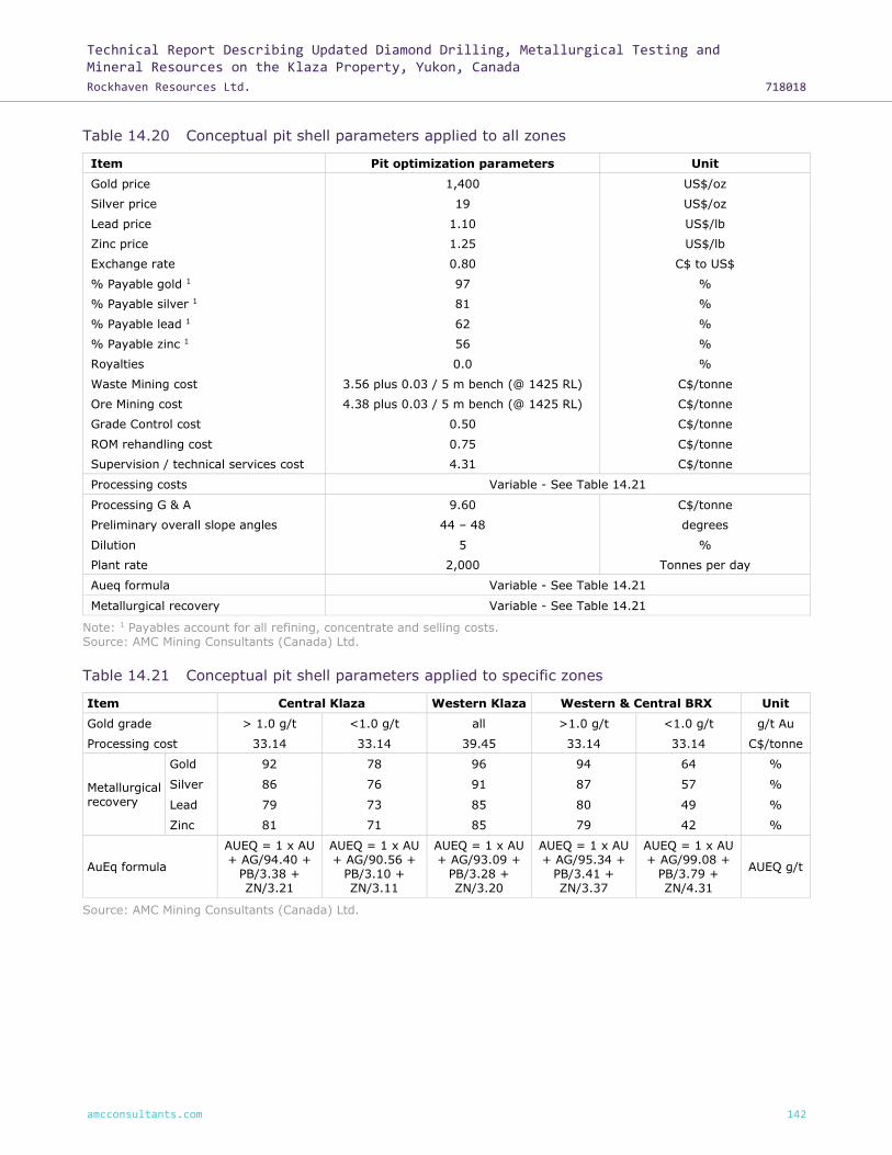
Technical Report Describing Updated Diamond Drilling, Metallurgical Testing and Mineral Resources on the Klaza Property, Yukon, Canada
Rockhaven Resources Ltd. 718018
amcconsultants.com 142
Table 14.20 Conceptual pit shell parameters applied to all zones
Item Pit optimization parameters Unit
Gold price 1,400 US$/oz
Silver price 19 US$/oz
Lead price 1.10 US$/lb
Zinc price 1.25 US$/lb
Exchange rate 0.80 C$ to US$
% Payable gold 1 97 %
% Payable silver 1 81 %
% Payable lead 1 62 %
% Payable zinc 1 56 %
Royalties 0.0 %
Waste Mining cost 3.56 plus 0.03 / 5 m bench (@ 1425 RL) C$/tonne
Ore Mining cost 4.38 plus 0.03 / 5 m bench (@ 1425 RL) C$/tonne
Grade Control cost 0.50 C$/tonne
ROM rehandling cost 0.75 C$/tonne
Supervision / technical services cost 4.31 C$/tonne
Processing costs Variable - See Table 14.21
Processing G & A 9.60 C$/tonne
Preliminary overall slope angles 44 – 48 degrees
Dilution 5 %
Plant rate 2,000 Tonnes per day
Aueq formula Variable - See Table 14.21
Metallurgical recovery Variable - See Table 14.21
Note: 1 Payables account for all refining, concentrate and selling costs. Source: AMC Mining Consultants (Canada) Ltd.
Table 14.21 Conceptual pit shell parameters applied to specific zones
Item Central Klaza Western Klaza Western & Central BRX Unit
Gold grade > 1.0 g/t <1.0 g/t all >1.0 g/t <1.0 g/t g/t Au
Processing cost 33.14 33.14 39.45 33.14 33.14 C$/tonne
Metallurgical recovery
Gold 92 78 96 94 64 %
Silver 86 76 91 87 57 %
Lead 79 73 85 80 49 %
Zinc 81 71 85 79 42 %
AuEq formula
AUEQ = 1 x AU + AG/94.40 +
PB/3.38 + ZN/3.21
AUEQ = 1 x AU + AG/90.56 +
PB/3.10 + ZN/3.11
AUEQ = 1 x AU + AG/93.09 +
PB/3.28 + ZN/3.20
AUEQ = 1 x AU + AG/95.34 +
PB/3.41 + ZN/3.37
AUEQ = 1 x AU + AG/99.08 +
PB/3.79 + ZN/4.31
AUEQ g/t
Source: AMC Mining Consultants (Canada) Ltd.
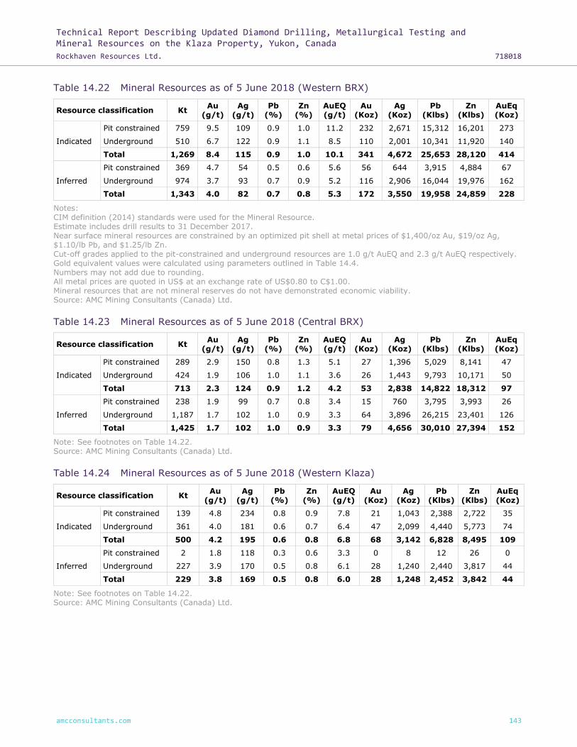
Technical Report Describing Updated Diamond Drilling, Metallurgical Testing and Mineral Resources on the Klaza Property, Yukon, Canada
Rockhaven Resources Ltd. 718018
amcconsultants.com 143
Table 14.22 Mineral Resources as of 5 June 2018 (Western BRX)
Resource classification Kt Au
(g/t) Ag
(g/t) Pb
(%) Zn
(%) AuEQ (g/t)
Au (Koz)
Ag (Koz)
Pb (Klbs)
Zn (Klbs)
AuEq (Koz)
Indicated
Pit constrained 759 9.5 109 0.9 1.0 11.2 232 2,671 15,312 16,201 273
Underground 510 6.7 122 0.9 1.1 8.5 110 2,001 10,341 11,920 140
Total 1,269 8.4 115 0.9 1.0 10.1 341 4,672 25,653 28,120 414
Inferred
Pit constrained 369 4.7 54 0.5 0.6 5.6 56 644 3,915 4,884 67
Underground 974 3.7 93 0.7 0.9 5.2 116 2,906 16,044 19,976 162
Total 1,343 4.0 82 0.7 0.8 5.3 172 3,550 19,958 24,859 228
Notes: CIM definition (2014) standards were used for the Mineral Resource. Estimate includes drill results to 31 December 2017. Near surface mineral resources are constrained by an optimized pit shell at metal prices of $1,400/oz Au, $19/oz Ag, $1.10/lb Pb, and $1.25/lb Zn. Cut-off grades applied to the pit-constrained and underground resources are 1.0 g/t AuEQ and 2.3 g/t AuEQ respectively. Gold equivalent values were calculated using parameters outlined in Table 14.4. Numbers may not add due to rounding. All metal prices are quoted in US$ at an exchange rate of US$0.80 to C$1.00. Mineral resources that are not mineral reserves do not have demonstrated economic viability. Source: AMC Mining Consultants (Canada) Ltd.
Table 14.23 Mineral Resources as of 5 June 2018 (Central BRX)
Resource classification Kt Au
(g/t) Ag
(g/t) Pb
(%) Zn
(%) AuEQ (g/t)
Au (Koz)
Ag (Koz)
Pb (Klbs)
Zn (Klbs)
AuEq (Koz)
Indicated
Pit constrained 289 2.9 150 0.8 1.3 5.1 27 1,396 5,029 8,141 47
Underground 424 1.9 106 1.0 1.1 3.6 26 1,443 9,793 10,171 50
Total 713 2.3 124 0.9 1.2 4.2 53 2,838 14,822 18,312 97
Inferred
Pit constrained 238 1.9 99 0.7 0.8 3.4 15 760 3,795 3,993 26
Underground 1,187 1.7 102 1.0 0.9 3.3 64 3,896 26,215 23,401 126
Total 1,425 1.7 102 1.0 0.9 3.3 79 4,656 30,010 27,394 152
Note: See footnotes on Table 14.22. Source: AMC Mining Consultants (Canada) Ltd.
Table 14.24 Mineral Resources as of 5 June 2018 (Western Klaza)
Resource classification Kt Au
(g/t) Ag
(g/t) Pb
(%) Zn
(%) AuEQ (g/t)
Au (Koz)
Ag (Koz)
Pb (Klbs)
Zn (Klbs)
AuEq (Koz)
Indicated
Pit constrained 139 4.8 234 0.8 0.9 7.8 21 1,043 2,388 2,722 35
Underground 361 4.0 181 0.6 0.7 6.4 47 2,099 4,440 5,773 74
Total 500 4.2 195 0.6 0.8 6.8 68 3,142 6,828 8,495 109
Inferred
Pit constrained 2 1.8 118 0.3 0.6 3.3 0 8 12 26 0
Underground 227 3.9 170 0.5 0.8 6.1 28 1,240 2,440 3,817 44
Total 229 3.8 169 0.5 0.8 6.0 28 1,248 2,452 3,842 44
Note: See footnotes on Table 14.22. Source: AMC Mining Consultants (Canada) Ltd.

Technical Report Describing Updated Diamond Drilling, Metallurgical Testing and Mineral Resources on the Klaza Property, Yukon, Canada
Rockhaven Resources Ltd. 718018
amcconsultants.com 144
Table 14.25 Mineral Resources as of 5 June 2018 (Central Klaza)
Resource classification Kt Au
(g/t) Ag
(g/t) Pb
(%) Zn
(%) AuEQ (g/t)
Au (Koz)
Ag (Koz)
Pb (Klbs)
Zn (Klbs)
AuEq (Koz)
Indicated
Pit constrained 1,260 3.3 49 0.6 0.9 4.3 133 1,987 16,414 25,871 173
Underground 715 3.9 62 0.6 0.7 5.0 90 1,432 9,550 11,309 114
Total 1,976 3.5 54 0.6 0.9 4.5 223 3,419 25,964 37,180 288
Inferred
Pit constrained 1,145 2.1 28 0.3 0.4 2.6 76 1,017 7,176 9,696 94
Underground 1,572 3.0 68 0.5 0.7 4.1 151 3,431 17,948 23,385 206
Total 2,717 2.6 51 0.4 0.6 3.4 227 4,448 25,124 33,081 301
Note: See footnotes on Table 14.22. Source: AMC Mining Consultants (Canada) Ltd.
The results of the pit constrained Mineral Resource estimates for the BRX and Klaza deposits are
shown in Table 14.26 and Table 14.27 at a range of cut-off grades. The base case cut-off grade
derived from parameters outlined in Table 14.20 and Table 14.21 is highlighted in bold.
Table 14.26 Klaza and BRX deposits pit-constrained Indicated Mineral Resource estimate (all
zones) cut-off grade sensitivity
Cut-off grade (g/t
AuEq)
Tonnes (kt)
Au (g/t)
Ag (g/t)
Pb (%)
Zn (%)
AuEq (g/t)
Metal (Au Koz)
Metal (Ag Koz)
Metal (Pb Klb)
Metal (Zn Klb)
Metal (AuEq Koz)
0.00 2,491 5.2 89 0.7 1.0 6.6 414 7,120 39,280 53,171 530
0.50 2,487 5.2 89 0.7 1.0 6.6 414 7,118 39,270 53,150 530
0.75 2,471 5.2 90 0.7 1.0 6.7 414 7,113 39,238 53,082 530
1.00 2,447 5.3 90 0.7 1.0 6.7 414 7,096 39,143 52,935 529
1.25 2,399 5.3 92 0.7 1.0 6.8 412 7,066 38,928 52,665 527
1.50 2,303 5.5 95 0.8 1.0 7.1 409 6,999 38,428 52,029 523
1.75 2,216 5.7 97 0.8 1.1 7.3 406 6,916 37,881 51,418 518
2.00 2,147 5.8 99 0.8 1.1 7.5 403 6,838 37,391 50,838 514
2.50 1,951 6.3 106 0.8 1.1 8.0 393 6,621 36,121 48,570 500
3.00 1,789 6.7 111 0.9 1.2 8.4 383 6,381 34,781 46,493 486
Notes: CIM definition (2014) standards were used for the Mineral Resource. Estimate includes drill results to 31 December 2017. Near surface mineral resources are constrained by an optimized pit shell at metal prices of $1,400/oz Au, $19/oz Ag, $1.10/lb Pb, and $1.25/lb Zn. Cut-off grades applied to the pit-constrained are 1.0 g/t AuEQ.
Gold equivalent values were calculated using parameters outlined in Table 14.4. Numbers may not add due to rounding. Mineral resources that are not mineral reserves do not have demonstrated economic viability. Source: AMC Mining Consultants (Canada) Ltd.
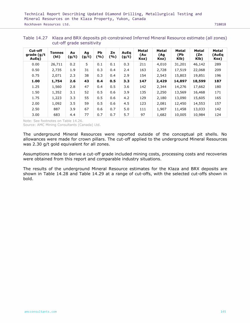
Technical Report Describing Updated Diamond Drilling, Metallurgical Testing and Mineral Resources on the Klaza Property, Yukon, Canada
Rockhaven Resources Ltd. 718018
amcconsultants.com 145
Table 14.27 Klaza and BRX deposits pit-constrained Inferred Mineral Resource estimate (all zones)
cut-off grade sensitivity
Cut-off grade (g/t
AuEq)
Tonnes (kt)
Au (g/t)
Ag (g/t)
Pb (%)
Zn (%)
AuEq (g/t)
Metal (Au Koz)
Metal (Ag Koz)
Metal (Pb Klb)
Metal (Zn Klb)
Metal (AuEq Koz)
0.00 26,711 0.2 5 0.1 0.1 0.3 211 4,010 31,201 46,142 289
0.50 2,735 1.9 31 0.3 0.4 2.4 163 2,728 17,519 22,068 209
0.75 2,071 2.3 38 0.3 0.4 2.9 154 2,543 15,803 19,851 196
1.00 1,754 2.6 43 0.4 0.5 3.3 147 2,429 14,897 18,599 187
1.25 1,560 2.8 47 0.4 0.5 3.6 142 2,344 14,276 17,662 180
1.50 1,352 3.1 52 0.5 0.6 3.9 135 2,250 13,569 16,468 171
1.75 1,223 3.3 55 0.5 0.6 4.2 129 2,180 13,090 15,605 165
2.00 1,092 3.5 59 0.5 0.6 4.5 123 2,081 12,450 14,553 157
2.50 887 3.9 67 0.6 0.7 5.0 111 1,907 11,458 13,033 142
3.00 683 4.4 77 0.7 0.7 5.7 97 1,682 10,005 10,984 124
Note: See footnotes on Table 14.26. Source: AMC Mining Consultants (Canada) Ltd.
The underground Mineral Resources were reported outside of the conceptual pit shells. No
allowances were made for crown pillars. The cut-off applied to the underground Mineral Resources
was 2.30 g/t gold equivalent for all zones.
Assumptions made to derive a cut-off grade included mining costs, processing costs and recoveries
were obtained from this report and comparable industry situations.
The results of the underground Mineral Resource estimates for the Klaza and BRX deposits are
shown in Table 14.28 and Table 14.29 at a range of cut-offs, with the selected cut-offs shown in
bold.

Technical Report Describing Updated Diamond Drilling, Metallurgical Testing and Mineral Resources on the Klaza Property, Yukon, Canada
Rockhaven Resources Ltd. 718018
amcconsultants.com 146
Table 14.28 Klaza and BRX deposits underground Indicated Mineral Resource estimate (all zones)
cut-off grade sensitivity
Cut-off grade (g/t
AuEq)
Tonnes (kt)
Au (g/t)
Ag (g/t)
Pb (%)
Zn (%)
AuEq (g/t)
Metal (Au Koz)
Metal (Ag Koz)
Metal (Pb Klb)
Metal (Zn Klb)
Metal (AuEq Koz)
0.00 2,775 3.3 87 0.6 0.7 4.7 297 7,765 37,805 44,782 416
1.00 2,642 3.5 91 0.6 0.8 4.9 295 7,706 37,471 44,217 413
1.50 2,427 3.7 96 0.7 0.8 5.2 289 7,517 36,609 42,858 404
1.75 2,312 3.8 99 0.7 0.8 5.3 286 7,385 35,937 41,938 398
2.00 2,174 4.0 103 0.7 0.9 5.6 280 7,205 35,170 40,824 389
2.30 2,010 4.2 108 0.8 0.9 5.8 272 6,974 34,125 39,172 378
2.50 1,900 4.4 112 0.8 0.9 6.1 266 6,815 33,248 37,910 370
2.75 1,731 4.6 117 0.8 0.9 6.4 257 6,521 31,830 35,784 355
3.00 1,604 4.8 121 0.9 1.0 6.7 249 6,251 30,369 34,129 344
4.00 1,134 5.9 142 1.0 1.1 8.0 214 5,176 24,126 26,613 291
5.00 854 6.8 160 1.0 1.1 9.1 187 4,397 19,751 21,372 251
6.00 670 7.7 172 1.1 1.2 10.2 165 3,703 15,773 17,232 219
Notes: CIM definition (2014) standards were used for the Mineral Resource. Estimate includes drill results to 31 December 2017. Cut-off grades applied to the underground are 2.3 g/t AuEQ. Gold equivalent values were calculated using parameters outlined in Table 14.4. Numbers may not add due to rounding. Mineral resources that are not mineral reserves do not have demonstrated economic viability. Source: AMC Mining Consultants (Canada) Ltd.
Table 14.29 Klaza and BRX deposits underground Inferred Mineral Resource estimate (all zones)
cut-off grade sensitivity
Cut-off grade (g/t
AuEq)
Tonnes (kt)
Au (g/t)
Ag (g/t)
Pb (%)
Zn (%)
AuEq (g/t)
Metal (Au Koz)
Metal (Ag Koz)
Metal (Pb Klb)
Metal (Zn Klb)
Metal (AuEq Koz)
0.00 121,159 0.2 6 0.1 0.1 0.3 839 23,458 156,306 240,128 1,269
1.00 8,121 2.0 58 0.5 0.6 2.9 510 15,032 81,610 100,318 747
1.50 6,086 2.3 71 0.6 0.7 3.4 449 13,953 76,059 89,789 667
1.75 5,400 2.4 77 0.6 0.7 3.6 423 13,392 73,373 84,942 632
2.00 4,739 2.6 83 0.7 0.8 3.9 395 12,621 69,344 78,921 592
2.30 3,960 2.8 90 0.7 0.8 4.2 359 11,472 62,647 70,578 538
2.50 3,573 3.0 94 0.7 0.8 4.4 340 10,817 59,041 65,336 508
2.75 3,137 3.1 98 0.8 0.9 4.7 318 9,929 54,243 59,255 472
3.00 2,676 3.4 105 0.8 0.9 5.0 289 9,029 49,215 52,537 429
4.00 1,507 4.2 130 1.0 1.1 6.2 204 6,276 33,752 35,669 300
5.00 938 5.0 148 1.2 1.2 7.2 150 4,471 23,860 24,774 219
6.00 612 5.7 163 1.2 1.2 8.2 113 3,212 16,118 16,711 161
Note: See footnotes on Table 14.28. Source: AMC Mining Consultants (Canada) Ltd.
14.5 Comparison with previous Mineral Resource estimate
The previous Mineral Resource estimate on the Property was published AMC report titled “Technical
Report and PEA of the Klaza Au-Ag Deposit, Yukon, Canada” with an effective date of
26 February 2016.

Technical Report Describing Updated Diamond Drilling, Metallurgical Testing and Mineral Resources on the Klaza Property, Yukon, Canada
Rockhaven Resources Ltd. 718018
amcconsultants.com 147
Changes to the Mineral Resource estimate in this report are due predominately to:
• Additional drilling.
• Increased drill density facilitating the upgrade of material from the Inferred to Indicated
category.
• Increase in pit constrained portion of the mineral resource due to revised metallurgy and
processing costs.
• Changes in metal prices, and cut-off grades for pit-constrained and underground portions of
the Mineral Resource.
• The use of MIK / LMOK / ROK to estimate portions of the Central Klaza zone to model
subsidiary structures.
• New wireframing strategy that included wider intervals of mineralization resulted in domains
that were previously unclassified as a result of low sample support to now be estimated and
classified (most significant at WBRX).
Table 14.30 and Table 14.31 show the pit-constrained and underground comparisons respectively.
Table 14.30 Comparison of AMC 2015 and 2018 pit-constrained Mineral Resource estimation
December 2015 AMC Mineral Resource Estimate June 2018 AMC Mineral Resource Estimate
Resource classification Kt Au (g/t) Au (Koz) Resource classification Kt Au (g/t) Au (Koz)
Western BRX
Indicated - - - Indicated 759 9.5 232
Inferred 554 8.2 146 Inferred 369 4.7 56
Central BRX
Indicated - - - Indicated 289 2.9 27
Inferred 283 3.7 33 Inferred 238 1.9 15
Western Klaza
Indicated - - - Indicated 139 4.8 21
Inferred 81 6.7 18 Inferred 2 1.8 0
Central Klaza
Indicated - - - Indicated 1,260 3.3 133
Inferred 1,255 4.0 164 Inferred 1,145 2.1 76
Notes: CIM definition standards were used for the Mineral Resource. Using drilling results to 30 September 2015. Near surface mineral resources are constrained by an optimized pit shell at a gold price of US$1,300 oz. Cut-off grades applied to the pit-constrained and underground resources are 1.3 g/t AuEQ and 2.75 g/t
AuEQ respectively. Gold equivalent values were calculated using the following formula: AuEQ=Au+Ag/85+Pb/3.74+Zn/5.04 and assuming: US$1,300 oz Au, US$20 oz Ag, US$0.90 lb Pb and US$0.90 lb Zn with recoveries for each metal of Au: 96%, Ag: 91%, Pb: 85%, and Zn: 85%. Numbers may not add due to rounding. All metal prices are quoted in US$ at an exchange rate of US$0.80 to C$1.00. Mineral resources that are not mineral reserves do not have demonstrated economic viability. Source: AMC Mining Consultants (Canada) Ltd.
Notes: CIM definition standards were used for Mineral Resource estimates Estimate includes drill results to 31 December 2017. Near surface mineral resources are constrained by an optimized pit shell at metal prices of $1,400/oz, $19/oz Ag, $1.10/lb Pb, and $1.25/lb Zn. Cut-off grades applied to the pit-constrained and
underground resources are 1.0 g/t AuEQ and 2.3 g/t AuEQ respectively. Gold equivalent values were calculated using parameters outlined in Table 14.4. Numbers may not add due to rounding. Mineral resources that are not mineral reserves do not have demonstrated economic viability. Source: AMC Mining Consultants (Canada) Ltd.

Technical Report Describing Updated Diamond Drilling, Metallurgical Testing and Mineral Resources on the Klaza Property, Yukon, Canada
Rockhaven Resources Ltd. 718018
amcconsultants.com 148
Table 14.31 Comparison of AMC 2015 and 2018 underground Mineral Resource estimation
December 2015 AMC Mineral Resource Estimate June 2018 AMC Mineral Resource Estimate
Resource classification Kt Au (g/t) Au (Koz) Resource classification Kt Au (g/t) Au (Koz)
Western BRX
Indicated - - - Indicated 510 6.7 110
Inferred 814 7.9 206 Inferred 974 3.7 116
Central BRX
Indicated - - - Indicated 424 1.9 26
Inferred 1,027 2.6 87 Inferred 1,187 1.7 64
Western Klaza
Indicated - - - Indicated 361 4.0 47
Inferred 461 5.4 80 Inferred 227 3.9 28
Central Klaza
Indicated - - - Indicated 715 3.9 90
Inferred 2,539 3.7 305 Inferred 1,572 3.0 151
Notes: CIM definition standards were used for the Mineral Resource.
Using drilling results to 30 September 2015. Near surface mineral resources are constrained by an optimized pit shell at a gold price of US$1,300 oz. Cut-off grades applied to the pit-constrained and underground resources are 1.3 g/t AuEQ and 2.75 g/t AuEQ respectively. Gold equivalent values were calculated using the following formula: AuEQ=Au+Ag/85+Pb/3.74+Zn/5.04 and assuming: US$1,300 oz Au, US$20 oz Ag, US$0.90 lb Pb and US$0.90 lb Zn with recoveries for each metal of Au: 96%, Ag: 91%, Pb: 85%, and Zn: 85%. Numbers may not add due to rounding. All metal prices are quoted in US$ at an exchange rate of US$0.80 to C$1.00. Mineral resources that are not mineral reserves do not have demonstrated economic viability. Source: AMC Mining Consultants (Canada) Ltd.
Notes: CIM definition standards were used for Mineral Resource estimates
Estimate includes drill results to 31 December 2017. Near surface mineral resources are constrained by an optimized pit shell at metal prices of $1,400/oz, $19/oz Ag, $1.10/lb Pb, and $1.25/lb Zn. Cut-off grades applied to the pit-constrained and underground resources are 1.0 g/t AuEQ and 2.3 g/t AuEQ respectively. Gold equivalent values were calculated using parameters outlined in Table 14.4. Numbers may not add due to rounding. Mineral resources that are not mineral reserves do not have demonstrated economic viability. Source: AMC Mining Consultants (Canada) Ltd.

Technical Report Describing Updated Diamond Drilling, Metallurgical Testing and Mineral Resources on the Klaza Property, Yukon, Canada
Rockhaven Resources Ltd. 718018
amcconsultants.com 149
15 Mineral Reserve estimates
There are no Mineral Reserve estimates to report for the Property.

Technical Report Describing Updated Diamond Drilling, Metallurgical Testing and Mineral Resources on the Klaza Property, Yukon, Canada
Rockhaven Resources Ltd. 718018
amcconsultants.com 150
16 Mining methods
This report discloses the results of an updated Mineral Resource estimate incorporating 2016 and
2017 drilling results, and additional metallurgical studies. It is an update to those Mineral Resources
and metallurgical results reported in a PEA Technical Report prepared by AMC for Rockhaven in
February 2016. The results of the 2016 PEA Technical Report described herein are based on the
earlier Mineral Resource model, and the studies related to the PEA have not yet been updated to
consider the new Mineral Resource model and the modified metallurgical treatment scheme.
This section was taken from the NI 43-101 technical report titled “Technical Report and PEA for the
Klaza Au-Ag Deposit, Yukon Canada for Rockhaven Resources Ltd.” dated 26 February 2016. This
section remains unchanged and is included for completeness and continuity.
The PEA considered vein systems contained in two distinct zones – Klaza and BRX. Each zone can
be further broken down by relative location: West, Central and East. The two zones lend themselves
to open pit mining as the mineralized veins are located close to surface. The surrounding topography
is moderately steep with sufficient flat areas suitable for the placement of waste dumps and
stockpiles. The climate is favourable to open pit mining, with relatively light precipitation,
predominantly in the summer.
Mineralization has been identified through exploration drilling below the potential open pits to a
depth of approximately 450 m below surface; both zones remain open at depth and along strike.
Both the BRX and Klaza vein systems are amenable to mining by underground methods. In the
Central Klaza zone potential exists in the eastern extremity for underground mining. The eastern
extent is naturally separated from the remainder of the Central Klaza zone by low grade
mineralization. The eastern extent of the Central Klaza zone would be accessed by an independent
decline system and for mining purposes is termed Eastern Klaza. The Eastern BRX zone is only
considered as upside potential that warrants further study.
16.1 Hydrological parameters
In anticipation of a future application under the Yukon Environmental and Socioeconomic
Assessment Act (YESAA) and the Waters Act as part of the mine permitting process, Tetra Tech EBA
was retained by Rockhaven to install a groundwater monitoring well network in the area of the
mineralized zones at Klaza and to conduct a preliminary hydrogeological assessment.
A preliminary network consisting of five nested monitoring wells was installed, with well locations
downgradient of the main mineralized zones, including Western, Central, and Eastern BRX and
Western and Central Klaza.
In addition to the monitoring wells, four observations wells were installed with vibrating wire
piezometers (VWPs) to monitor pore pressures at three different depths in each of the wells. These
wells were installed in the Western, Central, and Eastern BRX areas, and Western and Central Klaza.
One shallow piezometer and one deep piezometer were installed at each location. The deep
piezometers target the sub-permafrost aquifer whereas the shallow piezometers were installed
within the anticipated active zone to monitor seasonal supra-permafrost groundwater.
Ground temperatures and permafrost conditions were assessed using subsurface temperature data
from the VWPs and one thermistor cable installed to a depth of about 100 m in the Central Klaza
zone.

Technical Report Describing Updated Diamond Drilling, Metallurgical Testing and Mineral Resources on the Klaza Property, Yukon, Canada
Rockhaven Resources Ltd. 718018
amcconsultants.com 151
The main conclusions of the preliminary hydrogeological assessment can be summarized as follows:
• Permafrost appears to act as a confining layer for the deeper bedrock aquifer. However, some
uncertainty remains with respect to the permafrost temperature, extent, and interaction with
groundwater that requires further data collection.
• The groundwater flow regime at the site is controlled by the steep terrain, with flow from areas
at higher elevations on the mountain slopes toward the valley bottoms and generally
mimicking the topography.
• Hydraulic conductivities of the granodiorite bedrock aquifer were inferred from packer tests
conducted in all four VWP observation wells and hydraulic response tests conducted in select
monitoring wells. Inferred hydraulic conductivities ranged over several orders of magnitude
from about 4 × 10⁻¹⁰ m/s to 1 × 10⁻⁵ m/s, with an average hydraulic conductivity of
2 × 10⁻⁸ m/s. Hydraulic conductivity in bedrock is inferred to be largely controlled by fracture
density and permeability.
• Groundwater samples for chemical analysis were collected from all monitoring wells in
August 2015. The results show a similar hydrogeochemical composition with slight differences
between samples due to sample location. All groundwater samples are of a calcium and / or
magnesium dominant cation type, and bicarbonate and / or sulphate anion type.
• All groundwater samples, including those collected in the area of the mineralized zones,
showed a near neutral to slightly basic pH (between 7 and 8).
Based on the above conclusions, AMC has assumed a relatively low groundwater inflow that can be
adequately pumped from the potential mine workings using submersible pumps and, in the
underground case, a six-inch discharge pipeline. The majority of the discharge water will be service
water for operating equipment with minor inflow from ground water.
16.2 Geotechnical parameters
Rockhaven provided 2010, 2011, 2012, 2014, and 2015 drilling information for the Property. Figure
16.1 shows drilling locations with lithology information. Granodiorite (GRD) represents 90% of the
total drilled length.

Technical Report Describing Updated Diamond Drilling, Metallurgical Testing and Mineral Resources on the Klaza Property, Yukon, Canada
Rockhaven Resources Ltd. 718018
amcconsultants.com 152
Figure 16.1 Drillhole locations and lithological units: Klaza and BRX zones (2010 – 2015)
Source: AMC Mining Consultants (Canada) Ltd.
Based on the available drillhole data, geotechnical design parameters were determined by AMC for
the potential open pit and underground mines, these are summarized in the following sections.
16.2.1 Local lithology
It is evident that the dominant lithological unit in the mineralized areas is granodiorite (90% of the
total drill metres). The other lithologies make up the remaining 10% (Table 16.1).
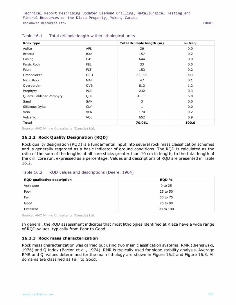
Technical Report Describing Updated Diamond Drilling, Metallurgical Testing and Mineral Resources on the Klaza Property, Yukon, Canada
Rockhaven Resources Ltd. 718018
amcconsultants.com 153
Table 16.1 Total drillhole length within lithological units
Rock type Total drillhole length (m) % freq.
Aplite APL 26 0.0
Breccia BXA 157 0.2
Casing CAS 644 0.9
Felsic Rock FEL 33 0.0
Fault FLT 153 0.2
Granodiorite GRD 63,096 90.1
Mafic Rock MAF 47 0.1
Overburden OVB 812 1.2
Porphyry POR 232 0.3
Quartz Feldspar Porphyry QFP 4,035 5.8
Sand SAN 3 0.0
Siliceous Dyke CLY 1 0.0
Vein VEN 170 0.2
Volcanic VOL 652 0.9
Total 70,061 100.0
Source: AMC Mining Consultants (Canada) Ltd.
16.2.2 Rock Quality Designation (RQD)
Rock quality designation (RQD) is a fundamental input into several rock mass classification schemes
and is generally regarded as a basic indicator of ground conditions. The RQD is calculated as the
ratio of the sum of the lengths of all core sticks greater than 10 cm in length, to the total length of
the drill core run, expressed as a percentage. Values and descriptions of RQD are presented in Table
16.2.
Table 16.2 RQD values and descriptions (Deere, 1964)
RQD qualitative description RQD %
Very poor 0 to 25
Poor 25 to 50
Fair 50 to 75
Good 75 to 90
Excellent 90 to 100
Source: AMC Mining Consultants (Canada) Ltd.
In general, the RQD assessment indicates that most lithologies identified at Klaza have a wide range
of RQD values, typically from Poor to Good.
16.2.3 Rock mass characterization
Rock mass characterization was carried out using two main classification systems: RMR (Bieniawski,
1976) and Q-index (Barton et al., 1974). RMR is typically used for slope stability analysis. Average
RMR and Q’ values determined for the main lithology are shown in Figure 16.2 and Figure 16.3. All
domains are classified as Fair to Good.

Technical Report Describing Updated Diamond Drilling, Metallurgical Testing and Mineral Resources on the Klaza Property, Yukon, Canada
Rockhaven Resources Ltd. 718018
amcconsultants.com 154
Figure 16.2 RMR76 by lithological domain
Source: AMC Mining Consultants (Canada) Ltd.

Technical Report Describing Updated Diamond Drilling, Metallurgical Testing and Mineral Resources on the Klaza Property, Yukon, Canada
Rockhaven Resources Ltd. 718018
amcconsultants.com 155
Figure 16.3 Q’ by lithological domain
Source: AMC Mining Consultants (Canada) Ltd.
16.2.4 Open pit geotechnical considerations
16.2.4.1 Open pit slope design
A number of slope stability analyses were carried out for the proposed open pits:
• Empirical analysis.
• 2D limit equilibrium (LE) analysis using Slide v6 (Rocscience, 2015).
• Probabilistic kinematic assessment.
The design criteria adopted were based on Factor of Safety (FOS) and Probability of Failure (POF)
calculations. Typical values of FOS used in pit design are indicated in Table 16.3.

Technical Report Describing Updated Diamond Drilling, Metallurgical Testing and Mineral Resources on the Klaza Property, Yukon, Canada
Rockhaven Resources Ltd. 718018
amcconsultants.com 156
Table 16.3 Typical FOS and POF acceptance criteria values (Read & Stacey, 2009)
Slope scale Consequence of
failure2
Acceptance criteria1
FOS (min) (static)
FOS (min) (dynamic)
POF (max) P (FOS </= 1)
Bench Low-high 1.1 NA 25 – 50%
Inter-ramp
Low 1.15 – 1.2 1.0 25%
Medium 1.2 1.0 20%
High 1.2 – 1.3 1.1 10%
Overall
Low 1.2 – 1.3 1.0 15 – 20%
Medium 1.3 1.05 5 – 10%
High 1.3 – 1.5 1.1 <5%
Notes: 1 Needs to meet all acceptance criteria. 2 Semi-quantitatively evaluated. Source: AMC Mining Consultants (Canada) Ltd.
16.2.4.2 Empirical analysis
An initial assessment of slope design parameters can be obtained from an empirical analysis based
on rock mass characterization data. The benefit of using empirical methods is that they are based
on experience gained from real cases of stable and failed slopes, with available information on rock
mass quality obtained from the rock mass classification systems.
An empirical slope design technique commonly used in the mining industry is the Haines-Terbrugge
approach (Haines and Terbrugge, 1991). The analysis is based on MRMR rock mass classification
system (Laubscher, 1990), which is a modification of RMR76 (Bieniawski, 1976) with adjustment
factors for joint orientation, weathering potential, blast damage, presence of water, and stress
effects. The adjustments are empirical with the values obtained from multiple observations in the
field. The estimated MRMR values for the host rock (GRD) and the mineralization (QFP) of the
Property are presented in Table 16.4. Estimated slope heights for these geotechnical domains are
also provided.
Table 16.4 MRMR and slope height by geotechnical domain
Domain RMRav Weathering Blasting Joints Water Stress MRMRav Slope height, m
GRD 60 0.96 0.94 0.8 0.9 1 41 100
QFP 56 0.96 0.94 0.8 0.9 1 39 100
Source: AMC Mining Consultants (Canada) Ltd.
The summary values can be plotted on the Haines-Terbrugge chart and pit slope angles determined
(Table 16.5).
Table 16.5 Summary of open pit slope angles based on empirical analyses
Domain Haines-Terbrugge (1990)
FOS=1.5 FOS=1.2
GRD 45 55
QFP 44 54
Source: AMC Mining Consultants (Canada) Ltd.

Technical Report Describing Updated Diamond Drilling, Metallurgical Testing and Mineral Resources on the Klaza Property, Yukon, Canada
Rockhaven Resources Ltd. 718018
amcconsultants.com 157
16.2.4.3 Limit equilibrium analysis
A series of limit equilibrium (LE) analyses by the “method of slices” was carried out for various slope
geometries using Slide software (Rocscience, 2015). The method of slices involves discretizing the
slope geometry into a number of slices. Multiple iterations are carried out analysing different failure
surfaces. For each iteration, force components are calculated based on the slice geometry above
the failure surface, as well as resultant forces from interaction with adjacent slices. A factor of safety
(FOS) is calculated for each failure surface as follows:
𝐹𝑂𝑆 =∑ 𝑅𝑒𝑠𝑖𝑠𝑡𝑖𝑛𝑔 𝐹𝑜𝑟𝑐𝑒𝑠
∑ 𝐷𝑟𝑖𝑣𝑖𝑛𝑔 𝐹𝑜𝑟𝑐𝑒𝑠
Where the resisting forces are related to the rock mass strength components resisting failure, and
driving forces are related to the weight of the slices and resultant forces promoting failure.
The input parameters for LE modelling, UCS – 35 MPa and GSI – 55, were assumed based on the
existing geotechnical data. The results show FOS for slope angles 45°- 55° is 3.4 - 2.8.
16.2.4.4 Kinematic analysis
Kinematic analyses were carried out for open pits to assess the potential for planar, wedge, and
toppling failure. The preliminary pit shells were used as the basis for sectoring. The pits were
sub-divided into the design sectors assumed on the four wall orientations (Figure 16.4).
Figure 16.4 Design sectors of open pit for kinematic analysis
Source: AMC Mining Consultants (Canada) Ltd.

Technical Report Describing Updated Diamond Drilling, Metallurgical Testing and Mineral Resources on the Klaza Property, Yukon, Canada
Rockhaven Resources Ltd. 718018
amcconsultants.com 158
Several assumptions were required for the kinematics:
• The slopes were assumed dry – without water pressure acting on the discontinuity planes.
• The role of tension cracking was ignored.
• The discontinuity planes are assumed persistent (continuous) frictional surfaces.
• The role of cohesion and rock bridging was ignored.
• Friction angle Ø = 30° for the probabilistic analyses.
Probabilistic kinematic assessments were carried out for each design sector to assess the potential
of the various failure mechanisms. The probabilistic assessment used the measured discontinuity
data per feature to assess the cumulative probability of planar or wedge failure.
The probability of failure (POF) can be related to the cumulative frequency (CF) in the kinematic
assessments, whereby POF = 50% would correspond to CF = 50% (since on a bench scale the
acceptable POF is in the range of 25% to 50%). However it should be noted that the CF is based on
kinematic analyses by individual pit sector, and does not consider the overall likelihood of failure
based on other rock mass factors such as major structure or low rock mass strength.
The wall angles associated with the CF of 20% and 50% are given in the kinematic tables below.
The Bench Face Angle (BFA) and Inter-ramp Angle (IRA) criteria are based on the acceptable
maximum POF of 50% (BFA) and 20% (IRA). The IRA criteria in conjunction with a “High” likelihood
of kinematic instabilities will be the control for the overall slope design. The BFA criteria will also
require “constructability” considerations. The results of the analysis for each sector (K1 to K4) are
provided in Table 16.6 (for BRX) and Table 16.7 (for Klaza).
Table 16.6 Probabilistic kinematic assessment results for open pit (BRX)
BFA (°) IRA (°)
Low High Low High
K1 54 75 42 48
K2 60 68 46 50
K3 54 64 39 50
K4 53 61 41 46
Source: AMC Mining Consultants (Canada) Ltd.
Table 16.7 Probabilistic kinematic assessment results for open pit (Klaza)
BFA (°) IRA (°)
Low High Low High
K1 59 74 46 50
K2 59 69 44 50
K3 52 64 39 46
K4 55 62 39 46
Source: AMC Mining Consultants (Canada) Ltd.
16.2.5 Pit wall design parameters
Pit slope design recommendations are shown in Table 16.8 (for BRX) and Table 16.9. (for Klaza).
The design parameters are based on the probabilistic kinematic analyses. The bench height was
limited to 10 m. The berm width of 6.0 m is considered to be sufficient to ensure retention of
bench-scale size failures. BFA exceeds the kinematic design acceptance (POF) criteria for all cases.

Technical Report Describing Updated Diamond Drilling, Metallurgical Testing and Mineral Resources on the Klaza Property, Yukon, Canada
Rockhaven Resources Ltd. 718018
amcconsultants.com 159
Some bench overbreak is projected. Therefore the design strategy will be to maintain adequate
catchment by maximizing berm width.
Identification and characterization of geological structure is one deficiency in the current design that
should be addressed in future work.
Table 16.8 Open pit design parameters for BRX
BFA (°) IRA (°) Bench height (m) Bench width (m)
Weathered Fresh Weathered Fresh
K1 60 75 39 48 10 6.5
K2 60 70 39 50 10 6.5
K3 60 65 39 50 10 6.5
K4 60 65 39 46 10 6.5
Source: AMC Mining Consultants (Canada) Ltd.
Table 16.9 Open pit design parameters for Klaza
BFA (°) IRA (°)
Bench height (m) Bench width (m) Weathered Fresh Weathered Fresh
K1 60 75 39 50 10 6.5
K2 60 70 39 50 10 6.5
K3 60 65 39 46 10 6.5
K4 60 65 39 46 10 6.5
Source: AMC Mining Consultants (Canada) Ltd.
16.2.6 Underground geotechnical considerations
16.2.6.1 Stable stope spans
AMC conducted the stope stability assessment using the empirical Stability Graph Method (SGM)
proposed by Mathews et al. (1981) and Potvin (1988). This approach is widely practiced in Australia
and North America to obtain a first-pass estimate of possible stope spans when little or no local
stoping experience is available. Stability of each stope wall is assessed separately.
Under the SGM, the stability number N' is calculated using the following expression:
𝑁′ = 𝑄′ × 𝐴 × 𝐵 × 𝐶
Where A is the rock stress factor, B is the joint orientation factor, and C is the gravity adjustment
factor.
The derivation of the adjustment factors A, B, and C is based on interpretation of the induced stress
around excavations, the dominant joint set orientation in relation to the face of interest and the dip
of the face. A low to moderate in situ stress regime is assumed. Factor C was calculated based on
an average range of the vein dip values (45° to 65°). The hydraulic radii of stable spans, with and
without support, can be determined from the stability graph (Figure 16.5).

Technical Report Describing Updated Diamond Drilling, Metallurgical Testing and Mineral Resources on the Klaza Property, Yukon, Canada
Rockhaven Resources Ltd. 718018
amcconsultants.com 160
Figure 16.5 Stability graph results for the stope walls: (a) unsupported and (b) supported (Vein
dip-55°)
(a)
(b)
Source: AMC Mining Consultants (Canada) Ltd.
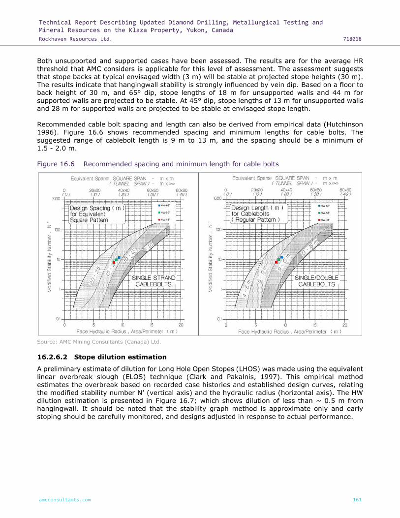
Technical Report Describing Updated Diamond Drilling, Metallurgical Testing and Mineral Resources on the Klaza Property, Yukon, Canada
Rockhaven Resources Ltd. 718018
amcconsultants.com 161
Both unsupported and supported cases have been assessed. The results are for the average HR
threshold that AMC considers is applicable for this level of assessment. The assessment suggests
that stope backs at typical envisaged width (3 m) will be stable at projected stope heights (30 m).
The results indicate that hangingwall stability is strongly influenced by vein dip. Based on a floor to
back height of 30 m, and 65° dip, stope lengths of 18 m for unsupported walls and 44 m for
supported walls are projected to be stable. At 45° dip, stope lengths of 13 m for unsupported walls
and 28 m for supported walls are projected to be stable at envisaged stope length.
Recommended cable bolt spacing and length can also be derived from empirical data (Hutchinson
1996). Figure 16.6 shows recommended spacing and minimum lengths for cable bolts. The
suggested range of cablebolt length is 9 m to 13 m, and the spacing should be a minimum of
1.5 - 2.0 m.
Figure 16.6 Recommended spacing and minimum length for cable bolts
Source: AMC Mining Consultants (Canada) Ltd.
16.2.6.2 Stope dilution estimation
A preliminary estimate of dilution for Long Hole Open Stopes (LHOS) was made using the equivalent
linear overbreak slough (ELOS) technique (Clark and Pakalnis, 1997). This empirical method
estimates the overbreak based on recorded case histories and established design curves, relating
the modified stability number N’ (vertical axis) and the hydraulic radius (horizontal axis). The HW
dilution estimation is presented in Figure 16.7; which shows dilution of less than ~ 0.5 m from
hangingwall. It should be noted that the stability graph method is approximate only and early
stoping should be carefully monitored, and designs adjusted in response to actual performance.

Technical Report Describing Updated Diamond Drilling, Metallurgical Testing and Mineral Resources on the Klaza Property, Yukon, Canada
Rockhaven Resources Ltd. 718018
amcconsultants.com 162
Figure 16.7 Stope dilution estimated for the HW
Source: AMC Mining Consultants (Canada) Ltd.
16.2.6.3 Preliminary ground support estimates
Preliminary ground support requirements have been estimated using the Q-system updated rock
reinforcement design chart (Grimstad and Barton, 1993), which relates rock quality, excavation
span, and service life to support requirements (Figure 16.8). The method converts the width (span)
of the excavation to an equivalent dimension (De), which takes into account the function of the
excavation.
Equivalent Dimension (De)
De = ESR
Span
and ESR = Excavation Support Ratio
Preliminary empirical ground support results are presented in Figure 16.8 It can be seen that all
excavations are located in the ‘unsupported’ category except intersection area. Based on modern
industry practices, such ground conditions will require moderate ground support installations.
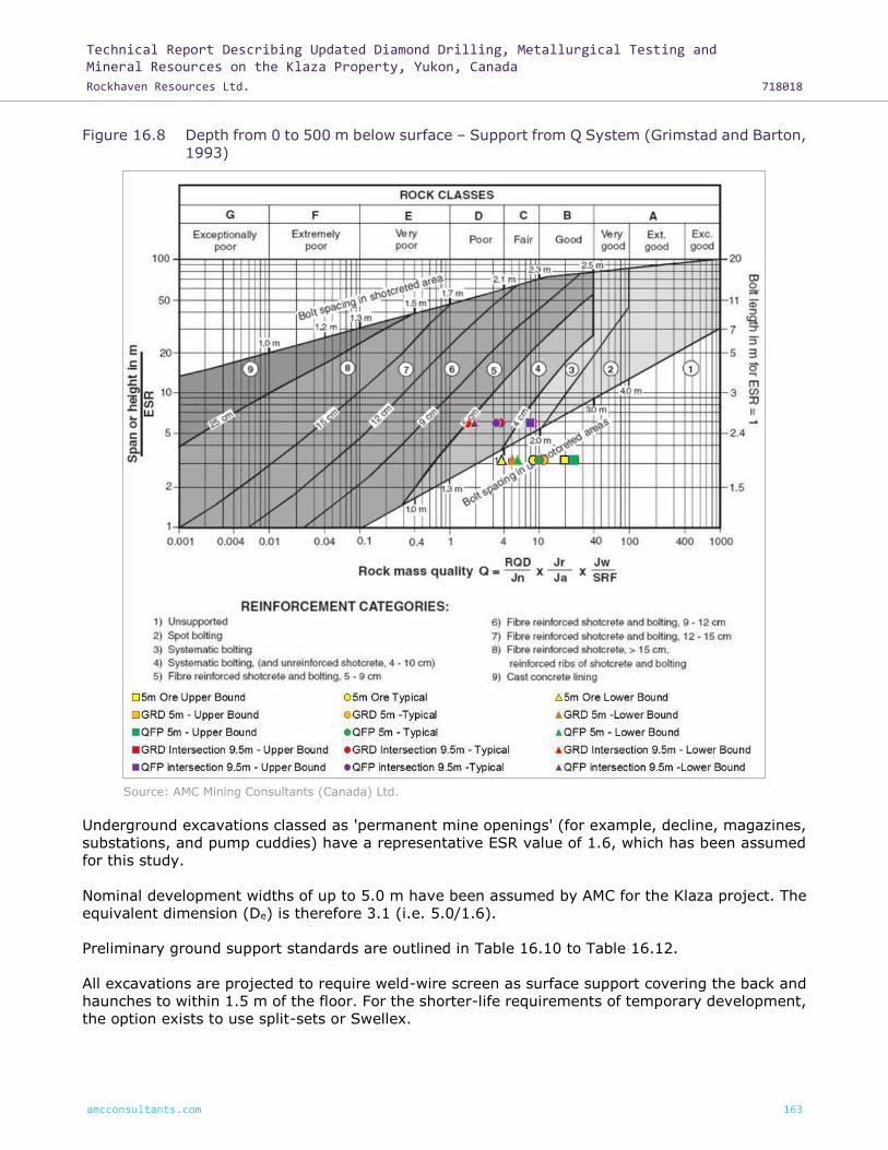
Technical Report Describing Updated Diamond Drilling, Metallurgical Testing and Mineral Resources on the Klaza Property, Yukon, Canada
Rockhaven Resources Ltd. 718018
amcconsultants.com 163
Figure 16.8 Depth from 0 to 500 m below surface – Support from Q System (Grimstad and Barton,
1993)
Source: AMC Mining Consultants (Canada) Ltd.
Underground excavations classed as 'permanent mine openings' (for example, decline, magazines,
substations, and pump cuddies) have a representative ESR value of 1.6, which has been assumed
for this study.
Nominal development widths of up to 5.0 m have been assumed by AMC for the Klaza project. The
equivalent dimension (De) is therefore 3.1 (i.e. 5.0/1.6).
Preliminary ground support standards are outlined in Table 16.10 to Table 16.12.
All excavations are projected to require weld-wire screen as surface support covering the back and
haunches to within 1.5 m of the floor. For the shorter-life requirements of temporary development,
the option exists to use split-sets or Swellex.

Technical Report Describing Updated Diamond Drilling, Metallurgical Testing and Mineral Resources on the Klaza Property, Yukon, Canada
Rockhaven Resources Ltd. 718018
amcconsultants.com 164
It should be noted that additional secondary ground support in the form of cables are projected to
be required in wide spans such as intersections. For permanent mine development, #6 (6/8 inch)
or #7 (7/8 inch) threaded rebar should be used. Poor ground conditions would require systematic
bolting as well as shotcrete support.
AMC notes that the ground-support guidance provided here is preliminary in nature and ultimate
requirements must be determined on-site and in consideration of actual ground conditions
encountered.
Table 16.10 Recommended ground support for Mineralized rock, GRD, and QFP rocks
Ground conditions Support system
Upper Bound (Good) 2.4 m bolts spaced 1.5 m x 1.5 m
Typical and Lower Bound (Fair) 2.4 m bolts spaced 1.2 m x 1.2 m
Source: AMC Mining Consultants (Canada) Ltd.
Table 16.11 Recommended ground support for GRD and QFP rocks (Intersections)
Ground conditions Support system
Upper Bound (Fair) 2.4 m bolts spaced 1.2 m x 1.2 m with shotcrete (4 - 5 cm), minimum cable length 6 m with 2.0 m spacing
Typical and Lower Bound (Poor) 2.4 m bolts spaced 1.2 m x 1.2 m with shotcrete (4 - 5 cm), minimum cable length 6 m with 2.0 m spacing
Source: AMC Mining Consultants (Canada) Ltd.
Table 16.12 Recommended ground support for Fault zones
Ground conditions Support system
Very poor 2.4 m bolts spaced 1.0 m x 1.0 m with fibre-reinforced shotcrete ( >12 cm), minimum cable length 6 m with 2.0 m spacing
Source: AMC Mining Consultants (Canada) Ltd.
16.3 Mineral Resource model for mining
AMC used the Mineral Resource estimate block models for the Klaza and BRX zones (reference:
rxh_brx_grd and rxh_brxe_grd) for evaluation of mining potential. The data used in the evaluation
includes results of all drilling carried out on the Property to 30 September 2015. The evaluation
work was carried out in Datamine™ software.
16.3.1 Gold equivalent
For reporting purposes an AuEQ (gold equivalent) field was calculated in the block model; the
formula used for BRX and Klaza was:
AuEQ = 1 * Au + Ag/106.5 + Pb/7.83 + Zn/14.45
16.4 Cut-off value
The cut-off value is based on NSR, which accounts for all downstream processing costs. A net
payable recovery for each metal was determined by H. M. Hamilton & Associates Inc. (HMH); the
payable recovery is based on marketing research that takes into account likely smelter terms and
penalties, transport, treatment and refining costs. AMC considers the assumptions used for
determining net payable recovery to be reasonable. The NSR cut-off value is based on the
assumptions shown in Table 16.13.

Technical Report Describing Updated Diamond Drilling, Metallurgical Testing and Mineral Resources on the Klaza Property, Yukon, Canada
Rockhaven Resources Ltd. 718018
amcconsultants.com 165
A variable processing cost was determined by Blue Coast Metallurgy (BCM) and validated by AMC
based on the arsenic feed grade for the BRX and Klaza zones. The cost is determined as follows:
Processing cost = 12.76*1650/1500+17.16+(12.3*((100-
12.3/As%0.6)*As%/(As%*4.44+3.37))/12.28*12.1/10.7),
Where throughput driven cost is C$12.76 * throughput ratio, fixed cost is C$17.16 and variable cost
is a function of the As% * C$12.30.
Due to the variable processing cost used for the BRX and Klaza zones, the cut-off value is based on
an adjusted NSR where:
Adjusted NSR Cut-off = NSR - Process Cost (Variable) = Process Cost (Fixed) + Mining Cost +
G&A
This is purely for reporting purposes to allow a fixed value to be reported against, in practice a
variable total cost is used for determining mineralization above cut-off value.
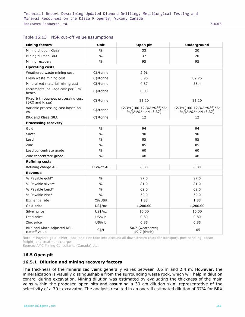
Technical Report Describing Updated Diamond Drilling, Metallurgical Testing and Mineral Resources on the Klaza Property, Yukon, Canada
Rockhaven Resources Ltd. 718018
amcconsultants.com 166
Table 16.13 NSR cut-off value assumptions
Mining factors Unit Open pit Underground
Mining dilution Klaza % 33 20
Mining dilution BRX % 37 20
Mining recovery % 95 95
Operating costs
Weathered waste mining cost C$/tonne 2.91
Fresh waste mining cost C$/tonne 3.96 82.75
Mineralized material mining cost C$/tonne 4.87 58.4
Incremental haulage cost per 5 m bench
C$/tonne 0.03
Fixed & throughput processing cost (BRX and Klaza)
C$/tonne 31.20 31.20
Variable processing cost based on As
C$/tonne 12.3*((100-12.3/As%0.6)*As
%/(As%*4.44+3.37) 12.3*((100-12.3/As%0.6)*As
%/(As%*4.44+3.37)
BRX and Klaza G&A C$/tonne 12 12
Processing recovery
Gold % 94 94
Silver % 90 90
Lead % 85 85
Zinc % 85 85
Lead concentrate grade % 60 60
Zinc concentrate grade % 48 48
Refining costs
Refining charge Au US$/oz Au 6.00 6.00
Revenue
% Payable gold* % 97.0 97.0
% Payable silver* % 81.0 81.0
% Payable Lead* % 62.0 62.0
% Payable zinc* % 52.0 52.0
Exchange rate C$/US$ 1.33 1.33
Gold price US$/oz 1,200.00 1,200.00
Silver price US$/oz 16.00 16.00
Lead price US$/lb 0.80 0.80
Zinc price US$/lb 0.85 0.85
BRX and Klaza Adjusted NSR cut-off value
C$/t 50.7 (weathered)
49.7 (fresh) 105
Note: * Payable gold, silver, lead, and zinc take into account all downstream costs for transport, port handling, ocean freight, and treatment charges. Source: AMC Mining Consultants (Canada) Ltd.
16.5 Open pit
16.5.1 Dilution and mining recovery factors
The thickness of the mineralized veins generally varies between 0.6 m and 2.4 m. However, the
mineralization is visually distinguishable from the surrounding waste rock, which will help in dilution
control during excavation. Mining dilution was estimated by evaluating the thickness of the main
veins within the proposed open pits and assuming a 30 cm dilution skin, representative of the
selectivity of a 30 t excavator. The analysis resulted in an overall estimated dilution of 37% for BRX

Technical Report Describing Updated Diamond Drilling, Metallurgical Testing and Mineral Resources on the Klaza Property, Yukon, Canada
Rockhaven Resources Ltd. 718018
amcconsultants.com 167
and 33% for Klaza. A mining recovery factor of 95% was applied. The mining dilution and recovery
were applied as factors during the pit optimization process and to estimate mill feed tonnes in the
schedule. The dilution material is assumed to have zero value. Dilution and recovery factors are
summarized in Table 16.14.
Table 16.14 Open pit mining dilution and recovery
Mining dilution (%) Mining recovery (%)
BRX 37 95
Klaza 33 95
Source: AMC Mining Consultants (Canada) Ltd.
16.5.2 Mining method
AMC proposes to mine the open pits using a conventional truck and excavator mining method. At
this stage, AMC has assumed that a 5 m bench height would be adopted and mineralized material
mined in two 2.5 m flitches to increase mining selectivity.
Three 30 t excavators would be required to mine waste and mineralized material. The productivity
of one 30 t excavator has been estimated at 396 t/hr in mineralized material, 439 t/hr in oxide
waste and 354 t/hr in fresh waste. The hydraulic excavators are planned to load 30 t articulated
dump trucks. At peak production in Year 1, five trucks are projected to be required.
The majority of the material will require blasting. Only a marginal portion of the material mined
may be free-dug by excavators. Proposed drilling parameters by material type are presented in
Table 16.15. AMC estimates that three top hammer drills would be required for production and
contour drilling along the side of the hills.
Table 16.15 Open pit drilling parameters
Unit Mineralized material Waste fresh Waste weathered
Bench height m 5 5 5
Drillhole diameter mm 75 75 75
Burden m 2.25 2.4 3
Spacing m 2.6 2.8 3.5
Sub-drill m 0.75 0.75 0.75
Charge length m 4.25 4.25 4.25
Stemming m 1.5 1.5 1.5
Powder factor kg/cum 0.6 0.5 0.3
Source: AMC Mining Consultants (Canada) Ltd.
Due to the projected short life of the open pit mines and the shallow mining depth, AMC has assumed
that no pre-split blasting would be required.
16.5.2.1 Stockpile rehandling
AMC assumed that one front-end loader would be required to rehandle material from the Run of
Mine pad (ROM pad) to blend stockpiles and limit grade variability to the mill. The front end loader
would also be used in the pit to provide support to the hydraulic excavators when required.

Technical Report Describing Updated Diamond Drilling, Metallurgical Testing and Mineral Resources on the Klaza Property, Yukon, Canada
Rockhaven Resources Ltd. 718018
amcconsultants.com 168
16.5.2.2 Ancillary equipment
AMC has determined ancillary equipment numbers as a relation to the total production fleet numbers
and based on its experience. Activities considered when estimating the auxiliary equipment fleet
include:
• Pioneering road establishment.
• Clean up of digging and drilling areas.
• Waste dump maintenance.
• Dust suppression and maintenance of haul roads.
• Servicing of the production fleet.
• Topsoil clearing.
The proposed support fleet consists of two 300 horsepower (HP) dozers for clearing topsoil, forming
waste dumps and stockpiles, and creating surface roads to the waste dumps and open pits at the
start of the operation. During the production phase, the dozers will provide support in the pits and
at the waste dumps. One grader and one water truck are planned for road maintenance, re-
contouring of rehabilitated areas and dust prevention.
16.5.3 Pit design and selection
The Lerchs-Grossmann pit optimization algorithm was used to define the ultimate pit shell for the
BRX and Klaza zones. The selected pit shells were then used to produce pit designs and the open
pit mining schedule.
16.5.3.1 Klaza ultimate pit selection
The optimization results for the Klaza zone are shown in Figure 16.9. The pit shell corresponding to
the 100% revenue factor is pit shell 16. Pit shell 15 was selected as the basis for the mining schedule
based on the results of the open pit to underground interface analysis.

Technical Report Describing Updated Diamond Drilling, Metallurgical Testing and Mineral Resources on the Klaza Property, Yukon, Canada
Rockhaven Resources Ltd. 718018
amcconsultants.com 169
Figure 16.9 Optimization results – Klaza
Source: AMC Mining Consultants (Canada) Ltd.
A sensitivity analysis of the selected open pit optimization was conducted at +/-10%, +/-20% for
processing costs, mining costs, dilution and NSR. Overall slope angle sensitivity of +/-3° was also
evaluated; the results are shown in Figure 16.10. The pit size, tonnes of mineralized material and
discounted (5%) cash flow are most sensitive to NSR, followed by mining and processing costs.

Technical Report Describing Updated Diamond Drilling, Metallurgical Testing and Mineral Resources on the Klaza Property, Yukon, Canada
Rockhaven Resources Ltd. 718018
amcconsultants.com 170
Figure 16.10 Pit optimization sensitivity analysis – discounted at 5%
Source: AMC Mining Consultants (Canada) Ltd.
16.5.3.2 Western BRX ultimate pit selection
The optimization results for the Western BRX zone are shown in Figure 16.11. The pit shell
corresponding to the 100% revenue factor is pit shell 17. However, based on the open pit to
underground interface analysis, described in Section 16.6, more value is generated by mining the
fresh mineralization using an underground mining method. Pit shell 3 was therefore selected to
define the limits of open pit mining.

Technical Report Describing Updated Diamond Drilling, Metallurgical Testing and Mineral Resources on the Klaza Property, Yukon, Canada
Rockhaven Resources Ltd. 718018
amcconsultants.com 171
Figure 16.11 Optimization results – Western BRX
Source: AMC Mining Consultants (Canada) Ltd.
16.5.3.3 Pit design
Conceptual pits were designed based on the selected pit optimizations. The conceptual designs for
the Western BRX and Klaza zones are presented in Figure 16.12 and Figure 16.14 respectively.
Representative pit design sections displaying Adjusted NSR (ADNSR) values for the mineralized
material are presented in Figure 16.13 and Figure 16.15.

Technical Report Describing Updated Diamond Drilling, Metallurgical Testing and Mineral Resources on the Klaza Property, Yukon, Canada
Rockhaven Resources Ltd. 718018
amcconsultants.com 172
Figure 16.12 Klaza pit design
Source: AMC Mining Consultants (Canada) Ltd.

Technical Report Describing Updated Diamond Drilling, Metallurgical Testing and Mineral Resources on the Klaza Property, Yukon, Canada
Rockhaven Resources Ltd. 718018
amcconsultants.com 173
Figure 16.13 Klaza pit sections showing ADNSR in C$/t
Source: AMC Mining Consultants (Canada) Ltd.

Technical Report Describing Updated Diamond Drilling, Metallurgical Testing and Mineral Resources on the Klaza Property, Yukon, Canada
Rockhaven Resources Ltd. 718018
amcconsultants.com 174
Figure 16.14 Western BRX pit design
Source: AMC Mining Consultants (Canada) Ltd.

Technical Report Describing Updated Diamond Drilling, Metallurgical Testing and Mineral Resources on the Klaza Property, Yukon, Canada
Rockhaven Resources Ltd. 718018
amcconsultants.com 175
Figure 16.15 Western BRX sections showing ADNSR in C$/t
Source: AMC Mining Consultants (Canada) Ltd.
Indicative tonnes and grades contained within the conceptual pit designs are presented in Table
16.16.
Table 16.16 Open pit projected tonnes and grades
Zone
Mineralized material tonnes
(Mt)
Waste material
tonnes (Mt)
ADNSR (C$)
AuEQ (g/t)
Au (g/t)
Ag (g/t)
Pb (%) Zn (%) Arsenic
(%)
Klaza 1.26 16.9 202 4.0 3.3 52.5 0.7 1.1 0.4
Western BRX 0.04 0.6 382 7.8 6.7 92.3 0.6 0.8 1.7
Total 1.31 17.5 205 4.0 3.4 51 0.7 1.1 0.5
Source: AMC Mining Consultants (Canada) Ltd.

Technical Report Describing Updated Diamond Drilling, Metallurgical Testing and Mineral Resources on the Klaza Property, Yukon, Canada
Rockhaven Resources Ltd. 718018
amcconsultants.com 176
16.5.4 Layout of other open pit mining related facilities
The general site layout for BRX and Klaza is shown in Figure 16.16. Waste dumps have been
designed to accommodate the totality of the waste mined from the pits; a proportion of the waste
material may be used for building the tailings dam wall and backfilling underground workings. The
waste dumps have been designed based on a 37 degree rill angle and to a maximum height of
approximately 55 m. Top soil stockpiles have been designed to handle the volume generated by
removing 30 cm from the surface area of the pits.
Figure 16.16 Layout of open pit infrastructure
Source: AMC Mining Consultants (Canada) Ltd.
16.5.5 Open pit equipment
The open pit operations are projected to work on a four panel, two shift roster. Features of this
roster are:
• 20 hours per day, 365 days per year, two shifts per day
• 12 hours per shift
• 4 days on, 4 days off
The above roster and the projected mining schedules (see Section 16.8) were used to derive peak
equipment requirements. Open pit primary equipment requirement at peak production is
summarized in Table 16.17.

Technical Report Describing Updated Diamond Drilling, Metallurgical Testing and Mineral Resources on the Klaza Property, Yukon, Canada
Rockhaven Resources Ltd. 718018
amcconsultants.com 177
Table 16.17 Equipment selection
Equipment type Peak No. required
30 t Excavator 3
Front-end loader 1
28 t Articulated dump truck 5
Top-hammer drill 3
Dozer (300 HP) 2
Grader (CAT 140 M) 1
Water truck 1
Total 25
Source: AMC Mining Consultants (Canada) Ltd.
16.5.6 Open pit labour and supervision
Contractor personnel numbers were estimated for all mining departments, including management
and supervision, technical staff, operators and maintenance. The total number of personnel required
was estimated based on the production throughput of the operation and the equipment numbers.
Total operator numbers were calculated for the number of machines on site at any given time.
Equipment such as trucks, excavators, drills and dozers were considered to be manned at all times.
The number of maintenance personnel was derived using a maintenance labour factor of 0.5 for the
main pieces of equipment.
Contractor management and senior staff were assumed to work on a 5-day week, Monday to Friday.
Unskilled and some skilled positions are anticipated to be filled by the local workforce. AMC has
assumed that the workforce will be accommodated in nearby Carmacks.
The peak requirements for the open pit workforce are summarized in Table 16.18.
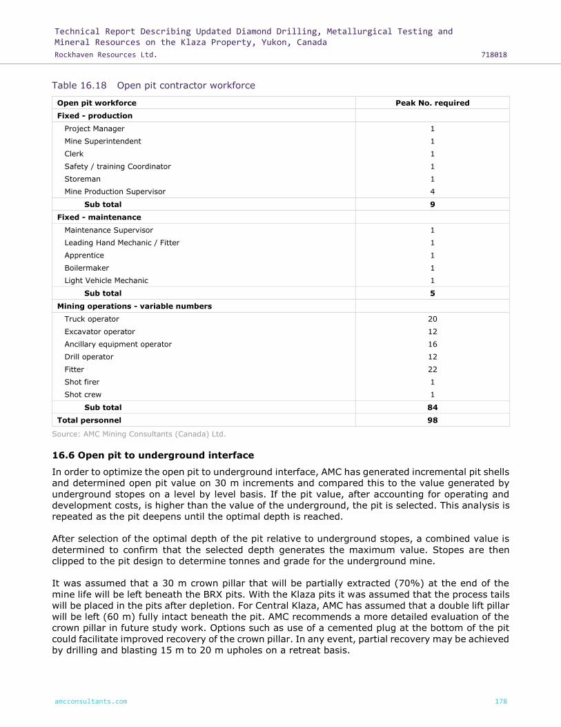
Technical Report Describing Updated Diamond Drilling, Metallurgical Testing and Mineral Resources on the Klaza Property, Yukon, Canada
Rockhaven Resources Ltd. 718018
amcconsultants.com 178
Table 16.18 Open pit contractor workforce
Open pit workforce Peak No. required
Fixed - production
Project Manager 1
Mine Superintendent 1
Clerk 1
Safety / training Coordinator 1
Storeman 1
Mine Production Supervisor 4
Sub total 9
Fixed - maintenance
Maintenance Supervisor 1
Leading Hand Mechanic / Fitter 1
Apprentice 1
Boilermaker 1
Light Vehicle Mechanic 1
Sub total 5
Mining operations - variable numbers
Truck operator 20
Excavator operator 12
Ancillary equipment operator 16
Drill operator 12
Fitter 22
Shot firer 1
Shot crew 1
Sub total 84
Total personnel 98
Source: AMC Mining Consultants (Canada) Ltd.
16.6 Open pit to underground interface
In order to optimize the open pit to underground interface, AMC has generated incremental pit shells
and determined open pit value on 30 m increments and compared this to the value generated by
underground stopes on a level by level basis. If the pit value, after accounting for operating and
development costs, is higher than the value of the underground, the pit is selected. This analysis is
repeated as the pit deepens until the optimal depth is reached.
After selection of the optimal depth of the pit relative to underground stopes, a combined value is
determined to confirm that the selected depth generates the maximum value. Stopes are then
clipped to the pit design to determine tonnes and grade for the underground mine.
It was assumed that a 30 m crown pillar that will be partially extracted (70%) at the end of the
mine life will be left beneath the BRX pits. With the Klaza pits it was assumed that the process tails
will be placed in the pits after depletion. For Central Klaza, AMC has assumed that a double lift pillar
will be left (60 m) fully intact beneath the pit. AMC recommends a more detailed evaluation of the
crown pillar in future study work. Options such as use of a cemented plug at the bottom of the pit
could facilitate improved recovery of the crown pillar. In any event, partial recovery may be achieved
by drilling and blasting 15 m to 20 m upholes on a retreat basis.

Technical Report Describing Updated Diamond Drilling, Metallurgical Testing and Mineral Resources on the Klaza Property, Yukon, Canada
Rockhaven Resources Ltd. 718018
amcconsultants.com 179
16.7 Underground mining
16.7.1 Underground mining method
The mining method selection criteria are based on:
• Vein geometry – Depth, shape, thickness, and plunge.
• Rock quality – Mineralized rock and host rock competency (structures, stress, and stability).
• Vein variability – Vein uniformity, continuity, and grade distribution.
• Economics – Metal recovery, value attributed to mineralization, productivity, capital and
operating costs, and safety.
The BRX and Klaza zones consist of several near vertical veins averaging 0.5 m to 3 m in width.
The strike length averages approximately 1,200 m for both zones and the vertical extent is
approximately 450 m below surface.
The vein geometry is most suited to the following mining methods:
• Longhole or Sublevel Stoping – Medium to steep dip, competent to fair ground.
• Shrinkage – Medium to steep dip, variable ground conditions.
• Cut and Fill – Medium to steep dip, variable ground conditions, high selectivity.
Relative to current overall knowledge of the Klaza deposits, AMC considers that the most appropriate
method is mechanized longhole open stoping. Longhole open stoping methods generally provide
relatively high productivity within reasonable cost limits. It is also the most common method applied
to narrow veins requiring a fair amount of selectivity, whilst maintaining reasonable production
rates.
Based on geotechnical recommendations, an inter-level spacing of 30 m is selected for the longhole
benches. Relative to the anticipated vein width, AMC notes that longhole drilling accuracy will be
very important in mining operations. Figure 16.17 shows the general arrangement of the longhole
mining method.
Access to the underground is via a single ramp (5 m by 5 m). Crosscuts are developed from the
ramp to each level. Development along the strike of the vein is 4 m by 4 m.
Waste sourced from underground development and open pit mining will be used to fill the stopes
as they are mined. A maximum open stope length of 24 m prior to filling with waste rockfill is
assumed for supported stopes.
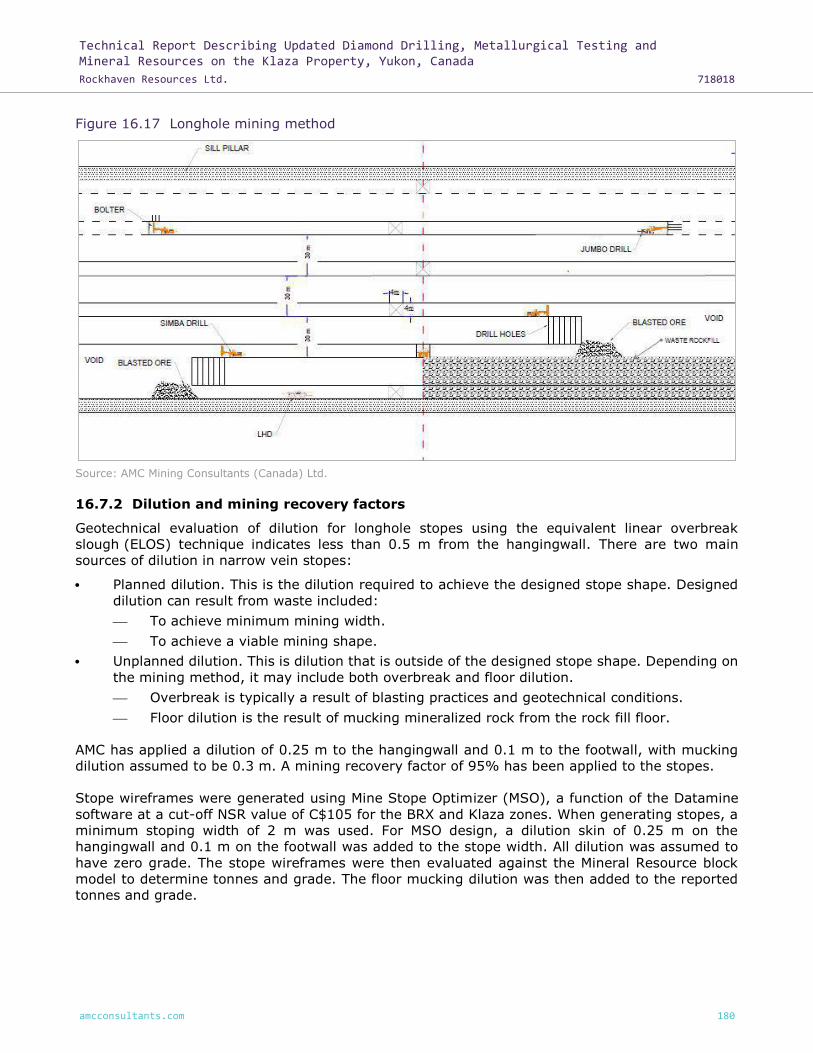
Technical Report Describing Updated Diamond Drilling, Metallurgical Testing and Mineral Resources on the Klaza Property, Yukon, Canada
Rockhaven Resources Ltd. 718018
amcconsultants.com 180
Figure 16.17 Longhole mining method
Source: AMC Mining Consultants (Canada) Ltd.
16.7.2 Dilution and mining recovery factors
Geotechnical evaluation of dilution for longhole stopes using the equivalent linear overbreak
slough (ELOS) technique indicates less than 0.5 m from the hangingwall. There are two main
sources of dilution in narrow vein stopes:
• Planned dilution. This is the dilution required to achieve the designed stope shape. Designed
dilution can result from waste included:
⎯ To achieve minimum mining width.
⎯ To achieve a viable mining shape.
• Unplanned dilution. This is dilution that is outside of the designed stope shape. Depending on
the mining method, it may include both overbreak and floor dilution.
⎯ Overbreak is typically a result of blasting practices and geotechnical conditions.
⎯ Floor dilution is the result of mucking mineralized rock from the rock fill floor.
AMC has applied a dilution of 0.25 m to the hangingwall and 0.1 m to the footwall, with mucking
dilution assumed to be 0.3 m. A mining recovery factor of 95% has been applied to the stopes.
Stope wireframes were generated using Mine Stope Optimizer (MSO), a function of the Datamine
software at a cut-off NSR value of C$105 for the BRX and Klaza zones. When generating stopes, a
minimum stoping width of 2 m was used. For MSO design, a dilution skin of 0.25 m on the
hangingwall and 0.1 m on the footwall was added to the stope width. All dilution was assumed to
have zero grade. The stope wireframes were then evaluated against the Mineral Resource block
model to determine tonnes and grade. The floor mucking dilution was then added to the reported
tonnes and grade.

Technical Report Describing Updated Diamond Drilling, Metallurgical Testing and Mineral Resources on the Klaza Property, Yukon, Canada
Rockhaven Resources Ltd. 718018
amcconsultants.com 181
16.7.3 Production rate analysis
In order to determine an appropriate production rate that can be supported by the deposit, AMC
has used a combination of Taylor`s rule of thumb and vertical tonnes per metre to project
production ranges.
Production rate based on Taylor’s rule of thumb, is estimated at 330 kilotonnes per annum (ktpa)
for BRX and 350 ktpa for Klaza for a combined annual production rate of 680 ktpa.
Annual Production Rate = 5 * Mineable mineralization 0.75
Most successful narrow vein mines do not exceed 30 to 40 vertical metres / annum. Based on the
mineralization by level, this would be equivalent to 200 to 250 ktpa for BRX and 300 to 350 ktpa
for Klaza, for a total annual production rate of 500 to 600 ktpa.
AMC recommends that the BRX and Klaza deposits be considered for mining as two virtually
independent operations at a combined production rate of 550 ktpa. This production rate is well
supported by the detailed production scheduling.
The Eastern BRX zone is located approximately 1 km east and along strike of the Western BRX zone.
The mineralization is different to both the Western and Central BRX and Klaza zones, with higher
grades of copper. Additional work is required to fully define the economics of this zone. The Eastern
BRX zone is not included in the economic assessment of the Western and Central BRX and Klaza
zones.
16.7.4 Stope design and selection
Stope wireframes were generated using MSO on a 3 m increment. Once the stopes were generated,
a check was made to remove any outlying stopes that would not be economic when the cost of
access development was included. Tonnes and grades by level were then used in the determination
of the optimum interface between the open pit and the underground.
The cost of access development was then determined for each level and each level was evaluated
to determine if the value was sufficient to pay for its access. Once the projected economic value
stopes were selected, the wireframes were combined into stopes 24 m in length. Stopes overlapping
with the pit were removed and crown pillars of 30 m and 60 m respectively for BRX and Klaza were
included in the design. For BRX, AMC has assumed that the crown pillar will be partially extracted
(70%) at the end of the mine life.
The Inferred Mineral Resource associated with the projected economic stopes is summarized in
Table 16.19 by zone. The total underground mineralization is estimated to be 5.1 Mt at grades of
3.31g/t Au, 84g/t Ag, 0.7% Pb and 0.8% Zn with an NSR value of C$209.
Table 16.19 Underground Inferred Mineral Resource
Zone Tonnes NSR (C$) AuEQ (g/t)
Au (g/t) Ag (g/t) Pb (%) Zn (%) Arsenic (ppm)
Western Klaza 662,505 205 4.38 3.14 107 0.4 0.5 4,113
Central Klaza 1,446,887 145 3.11 2.44 43 0.5 0.6 3,154
Western BRX 1,872,106 285 6.10 4.93 82 0.8 0.9 6,536
Central BRX 1,157,091 167 3.54 1.87 123 1.0 1.0 4,242
Total 5,138,589 209 4.46 3.31 84 0.7 0.8 4,755
Source: AMC Mining Consultants (Canada) Ltd.

Technical Report Describing Updated Diamond Drilling, Metallurgical Testing and Mineral Resources on the Klaza Property, Yukon, Canada
Rockhaven Resources Ltd. 718018
amcconsultants.com 182
16.7.5 Underground development
The BRX and Klaza veins are approximately parallel and 800 m apart, and as such separate declines
were designed for the Klaza and BRX. Access to the Klaza zone underground mine would be via a
5 m by 5 m decline and crosscuts on each level (West and Central). The Central Klaza zone has
several stopes further east along strike and these are accessed via an independent decline (Eastern
Klaza). Levels are spaced at a vertical distance of 30 m floor to floor. Development (4 m by 4m)
was designed to follow the vein along strike from a central access crosscut. The Klaza decline
commences from the portal on surface and splits into two declines to access the Western Klaza and
Central Klaza areas. Main access to the BRX zone has a similar design with a main (5 m by 5 m)
access decline that splits into two declines accessing the Western and Central BRX zones. The
proposed development required by zone is summarized in Table 16.20.
Table 16.20 Development physicals
Area Decline
(m) Access drives
(m) Ventilation access (m)
Ventilation raises (m)
Mineralized vein development (m)
Waste vein development (m)
Klaza 5,309 1,096 511 588 8,889 2,848
BRX 6,494 1,236 749 767 11,712 2,809
Total 11,803 2,332 1,260 1,355 20,601 5,657
Source: AMC Mining Consultants (Canada) Ltd.
Key underground design parameters are summarized in Table 16.21.
Table 16.21 Key underground design parameters
Parameter Assumption
Waste development dimensions 5 m by 5 m
Vein development dimensions 4 m by 4 m
Decline gradient 15%
Decline radius of curvature 25 m
Minimum stand-off distance to vein 36.5 m
Raises to surface for ventilation 4 m diameter
Allowance for sumps, loading bays 25% of crosscut length
Allowance for passing bays 13% of decline length (15 m every 150 m)
Source: AMC Mining Consultants (Canada) Ltd.
Isometric views of the BRX and Klaza proposed underground mines are provided in Figure 16.8 and
Figure 16.9.

Technical Report Describing Updated Diamond Drilling, Metallurgical Testing and Mineral Resources on the Klaza Property, Yukon, Canada
Rockhaven Resources Ltd. 718018
amcconsultants.com 183
Figure 16.18 BRX underground mine design
Source: AMC Mining Consultants (Canada) Ltd.
Figure 16.19 Klaza underground mine design
Source: AMC Mining Consultants (Canada) Ltd.
Western BRX
Central BRX
Western Klaza
Eastern Klaza
Central Klaza

Technical Report Describing Updated Diamond Drilling, Metallurgical Testing and Mineral Resources on the Klaza Property, Yukon, Canada
Rockhaven Resources Ltd. 718018
amcconsultants.com 184
16.7.6 Proposed infrastructure
The proposed underground mine services will include a small maintenance shop for minor and
urgent repairs, fuel, and lubricant storage, and a small explosives magazine at each mine.
Compressed air will be supplied by mobile electric compressors. The compressors will be relocated
to active mining levels as needed.
During development the decline will be equipped with power for distribution underground as well as
a four inch pipeline for mine service water and a six inch pipeline for dewatering.
Telecommunications will be provided by a conventional leaky feeder system.
16.7.7 Ventilation
AMC has undertaken a preliminary estimate of the ventilation requirements based on the
underground equipment rating and anticipated utilization. This estimate has been checked against
benchmark data for ventilation quantities. The function of the ventilation system is to
dilute / remove airborne dust, diesel emissions, explosive gases, and to maintain temperatures at
levels necessary to ensure safe production throughout the life of the mine.
For both zones, the mine will be ventilated by a “Pull” or exhausting type ventilation system. That
is, the primary mine ventilation fans will be located at the primary exhaust airways of the mine.
Fresh air will enter each mine via the decline portals with exhaust to the surface via a dedicated
return airway. In winter, air will be heated by direct propane gas fired heaters at the portal, with
the heat ducted to the intake airflow.
The proposed ventilation system has been modelled using Ventsim software to check air velocities
and practicality of the overall system. Based upon the equipment projected to be required, a
combined total of approximately 290 m³/s is planned for ventilation of both the BRX and Klaza
underground mines, primarily to provide adequate dilution of exhaust emissions from the planned
underground diesel equipment fleet and ensure sufficient supply of fresh air for personnel.
The primary surface exhaust fans required for the ventilation system are as follows:
• Western BRX exhaust fan – 250 HP.
• Central BRX exhaust fan – 100 HP.
• Western Klaza exhaust fan - 150 HP.
• Central Klaza exhaust fan – 200 HP.
• Eastern Klaza exhaust fan – 50 HP.
The proposed ventilation strategies for BRX and Klaza are shown in Figure 16.20 and Figure 16.21.

Technical Report Describing Updated Diamond Drilling, Metallurgical Testing and Mineral Resources on the Klaza Property, Yukon, Canada
Rockhaven Resources Ltd. 718018
amcconsultants.com 185
Figure 16.20 Proposed BRX ventilation system
Source: AMC Mining Consultants (Canada) Ltd.
Figure 16.21 Proposed Klaza ventilation system
Source: AMC Mining Consultants (Canada) Ltd.
16.7.8 Secondary egress
On all levels the planned main escape route is either the main decline or to the return air
raise (RAR). RARs will be equipped with ladderways for personnel egress. Refuge stations will be
placed strategically in the underground mine. Refuge stations will be portable for flexibility of
location, although lunch rooms will also be equipped as refuge stations.

Technical Report Describing Updated Diamond Drilling, Metallurgical Testing and Mineral Resources on the Klaza Property, Yukon, Canada
Rockhaven Resources Ltd. 718018
amcconsultants.com 186
16.7.9 Underground equipment
AMC has based its equipment selection and estimate of equipment numbers on operations of similar
production rates. AMC has assumed that there will be some synergy between the two independent
operations that will allow for sharing of any spare capacity equipment. The combined total
equipment requirement estimated for BRX and Klaza to support a combined production rate of
550 ktpa is summarized in Table 16.22.
Table 16.22 Equipment selection
Underground mobile equipment No of units
Production drill rig 4
2 Boom jumbo drill - development 4
Diesel LHD - production 3
Diesel LHD - development 3
UG haul truck (40 t) 5
UG water truck 1
Bolter 2
Cable bolter 2
Explosives loader 2
Personnel carrier 4
Scissor lift 4
Boom truck 2
Utility vehicle 5
Grader 1
Lubrication service truck 2
Mobile compressors 5
Source: AMC Mining Consultants (Canada) Ltd.
16.7.10 Underground labour and supervision
Labour will be sourced from the local community and area around Klaza. The mine workforce will
be encouraged to live in Carmacks and a daily bus service will be provided to drive the workforce
73 km to the mine and back.
AMC has estimated labour and supervision requirements at the full production rate. Staff is assumed
to work on a weekly roster while mining labour is assumed to work on a two weeks on one week off
basis. AMC has assumed two 12 hour shifts per day.
AMC has allowed for a combined open pit and underground technical services team in consideration
of the size of the operation as a whole. The technical services team is summarized in Table 16.23.

Technical Report Describing Updated Diamond Drilling, Metallurgical Testing and Mineral Resources on the Klaza Property, Yukon, Canada
Rockhaven Resources Ltd. 718018
amcconsultants.com 187
Table 16.23 Combined open pit and underground technical services
Combined OP and Underground technical services Number
Tech Services Superintendent 1
Scheduling Engineer 1
Mining Technologist (OP) 1
Geotechnical Engineer 1
Design Engineer 2
Production Engineer 2
Ventilation Engineer 1
Senior Surveyor 1
Surveyor 2
Senior Geologist 1
UG Mine Geologist 2
Technicians (OP) 2
Sub-total 17
Source: AMC Mining Consultants (Canada) Ltd.
The total labour and supervision personnel numbers including technical services are summarized in
Table 16.24.
Table 16.24 Underground labour and supervision
Management Number
Mining Manager 1
Administration Assistant 1
Clerk 1
Supervision
Mine General Foreman 2
Shift Supervisor 12
Labour
Workplace Trainer / Safety 3
Jumbo Operator 12
Production Driller 12
Charge / Scale 9
Loader operator 18
Service Crew 15
Grader Driver 3
Truck Driver 15
Nipper 6
Maintenance
Senior Maintenance Engineer 1
Maintenance Planner 2
Mechanical Foreman 2
Electrical Foreman 2
Leading Hand Mechanics 3
Shift Mechanics 9
Electricians 3

Technical Report Describing Updated Diamond Drilling, Metallurgical Testing and Mineral Resources on the Klaza Property, Yukon, Canada
Rockhaven Resources Ltd. 718018
amcconsultants.com 188
Management Number
Millwright 3
Shift Serviceman 6
Electrical Leading Hand 3
Shift Electricians 6
Pump Fitters 3
Electrical Assistant 3
Total staff (including technical services) 41
Total labour 132
Total 173
Source: AMC Mining Consultants (Canada) Ltd.
16.8 Projected life-of-mine development and production schedule
16.8.1 Mine sequence optimization
In order to optimize the overall value of the project and the sequence of mining, AMC has estimated
revenue for each pit and each underground zone. The areas were then ranked in order of value
after accounting for mining costs. The projected revenue from each source and consideration of
practical scheduling constraints provided a basis for the order in which the pits and underground
zones are scheduled. In addition, a focus to get the open pits mined early in the mine life was
maintained in order to enable placement of process tailings in the pits. The pit and underground
areas are ranked by value as shown in Table 16.25.
Table 16.25 Ranking of zone value
Zone Value (C$/t) Ranking
Klaza Pit 1 142 3
Klaza Pit 2 82 4
Klaza Pit 3 39 7
Western BRX pit 254 1
Klaza West UG 72 5
Klaza Central / East UG 14 8
BRX West UG 159 2
BRX Central UG 41 6
Source: AMC Mining Consultants (Canada) Ltd.
Using the rankings shown above and the other referenced considerations, the planned initial
development and mining sequence is to mine out the shallow BRX pits while the main Klaza pit and
main access declines to the underground mines are developed. Underground development will
target opening up the high grade Western BRX and Western Klaza zones as the priority.
Underground mineralization is projected to be mined at a rate that, together with open pit
production, will generally fill the mill from around Year 2 through to Year 10. The Central Klaza
zones and Eastern Klaza zones and the Central BRX zone will be brought into production as the
open pit is depleted so as to maintain full production at 550 ktpa.
16.8.2 Conceptual open pit production schedule
The proposed open pit production schedule extends over a five year period and is summarized in
Table 16.26 and Figure 16.22.

Technical Report Describing Updated Diamond Drilling, Metallurgical Testing and Mineral Resources on the Klaza Property, Yukon, Canada
Rockhaven Resources Ltd. 718018
amcconsultants.com 189
Table 16.26 Conceptual open pit production schedule
OP production YR0 YR1 YR2 YR3 YR4 YR5 OP totals
Waste (Mt) 4.3 4.3 4.0 3.9 1.0 17.5
Mineralized rock (kt) 134 247 419 358 147 1,305
Mill feed (kt) 380 373 245 144 163 1,305
Mill feed AuEQ (g/t) 3.9 4.2 5.0 4.8 1.7 4.0
Mill feed Au (g/t) 3.4 3.6 4.1 3.7 1.5 3.4
Mill feed Ag (g/t) 39 46 69 99 21 51
Mill feed Pb (%) 0.6 0.8 0.9 0.7 0.3 0.7
Mill feed Zn (%) 1.2 1.2 1.2 0.9 0.3 1.1
Mill feed As (%) 0.6 0.5 0.5 0.4 0.2 0.5
Source: AMC Mining Consultants (Canada) Ltd.
Figure 16.22 Projected open pit production
Source: AMC Mining Consultants (Canada) Ltd.
16.8.3 Projected underground development schedule
The projected underground development schedule is summarized in Table 16.27 and Figure 16.23.

Technical Report Describing Updated Diamond Drilling, Metallurgical Testing and Mineral Resources on the Klaza Property, Yukon, Canada
Rockhaven Resources Ltd. 718018
amcconsultants.com 190
Table 16.27 Proposed underground development schedule
Description YR0 YR1 YR2 YR3 YR4 YR5 YR6 YR7
Access development (m) 1,990 2,418 1,468 2,582 3,359 2,624 2,824 932
Vein development (m) 264 1,272 1,314 1,946 2,108 2,796 3,762 2,626
Vertical development (m) 115 199 33 318 251 341 98
Description YR8 YR9 YR10 YR11 YR12 YR 13 Total
Access development (m) 200 1,887 501 9 20,793
Vein development (m) 1,860 1,433 1,100 228 145 34 20,887
Vertical development (m) 10 69 1,435
Source: AMC Mining Consultants (Canada) Ltd.
Figure 16.23 Projected underground development
Source: AMC Mining Consultants (Canada) Ltd.
16.8.4 Conceptual underground production schedule
The projected underground production schedule is summarized in Table 16.28 and Figure 16.24.

Technical Report Describing Updated Diamond Drilling, Metallurgical Testing and Mineral Resources on the Klaza Property, Yukon, Canada
Rockhaven Resources Ltd. 718018
amcconsultants.com 191
Table 16.28 Projected underground production schedule
UG production YR0 YR1 YR2 YR3 YR4 YR5 YR6 YR7
Mineralized rock (kt) 9 89.9 176.7 305.2 405.8 391.4 550.9 550.3
AuEQ (g/t) 7.7 5.7 4.5 5.5 6.7 4.5 5.2 5.1
Au (g/t) 6.6 4.5 3.7 4.5 5.2 3.4 4.0 3.7
Au (g/t) 73 94 52 74 101 72 96 103
Pb (%) 0.8 0.9 0.6 0.5 1.1 0.8 0.6 0.7
Zn (%) 0.8 0.5 0.7 0.8 1.0 0.8 0.7 0.8
As (%) 0.5 0.5 0.7 0.6 0.7 0.5 0.5 0.5
UG production YR8 YR9 YR10 YR11 YR12 YR13 YR14 Total
Mineralized rock (kt) 548.7 509.3 523.8 470.2 310.0 203.5 93.0 5,139
AuEQ (g/t) 4.6 3.7 3.4 3.5 3.3 2.9 2.9 4.5
Au (g/t) 3.4 2.5 2.2 2.3 2.6 2.2 2.5 3.3
Ag (g/t) 95 95 82 86 44 50 24 84
Pb (%) 0.6 0.8 0.8 0.9 0.6 0.3 0.2 0.7
Zn (%) 0.8 0.8 0.9 0.8 0.5 0.6 0.7 0.8
As (%) 0.6 0.4 0.4 0.4 0.3 0.3 0.1 0.5
Source: AMC Mining Consultants (Canada) Ltd.
Figure 16.24 Projected underground production
Source: AMC Mining Consultants (Canada) Ltd.

Technical Report Describing Updated Diamond Drilling, Metallurgical Testing and Mineral Resources on the Klaza Property, Yukon, Canada
Rockhaven Resources Ltd. 718018
amcconsultants.com 192
16.8.5 Waste rockfill
Stopes will be backfilled with waste rock on a sequential basis (stopes blasted nominally 24 m along
strike and then filled). Approximately 1.2 Mt of waste is planned to be produced from underground
over the life of the mine. Where possible, waste rock generated underground will be backfilled
directly into stopes, with excess waste stockpiled underground or transported to surface waste
dumps. The total waste required for backfilling the planned underground stopes is 3.6 Mt over the
life of the mine. Particularly in the latter stages of underground mine production it is planned that
waste will be back-hauled underground from the waste dumps for backfill.
The projected annual backfill requirements are summarized in Table 16.29 and shown in Figure
16.25.
Table 16.29 Projected annual underground waste rock fill schedule
Quantity YR0 YR1 YR2 YR3 YR4 YR5 YR6 YR7
Waste rock fill (kt) 36 107 178 272 240 343 376
Quantity YR8 YR9 YR10 YR11 YR12 YR13 YR14 Total
Waste rock fill (kt) 402 374 395 380 271 170 85 3,627
Source: AMC Mining Consultants (Canada) Ltd.
Figure 16.25 Projected underground waste rock fill requirements
Source: AMC Mining Consultants (Canada) Ltd.

Technical Report Describing Updated Diamond Drilling, Metallurgical Testing and Mineral Resources on the Klaza Property, Yukon, Canada
Rockhaven Resources Ltd. 718018
amcconsultants.com 193
16.8.6 Conceptual combined production schedule
The projected combined life-of-mine (LOM) production schedule for the open pit and underground
is summarized in Table 16.30. The conceptual schedule is shown together with the AuEQ grade in
Figure 16.26. The projected combined open pit and underground mine design is shown in Figure
16.27.
Table 16.30 Conceptual LOM production schedule
Production YR0 YR1 YR2 YR3 YR4 YR5 YR6 YR7
Waste (kt) 4,433 4,398 4,128 4,048 1,176 165 155 45
Mineralized rock (kt) 144 337 596 664 552 391 551 550
AuEQ (g/t) 3.3 4.8 4.1 4.7 6.2 4.5 5.1 5.1
Production YR8 YR9 YR10 YR11 YR12 YR13 YR14 Total
Waste (kt) 8 104 23 1 18,686
Mineralized rock (kt) 549 510 524 470 310 204 93 6,444
AuEQ (g/t) 4.6 3.7 3.4 3.5 3.3 2.9 2.9 4.4
Source: AMC Mining Consultants (Canada) Ltd.
Figure 16.26 Conceptual LOM production schedule and AuEQ grade
Source: AMC Mining Consultants (Canada) Ltd.
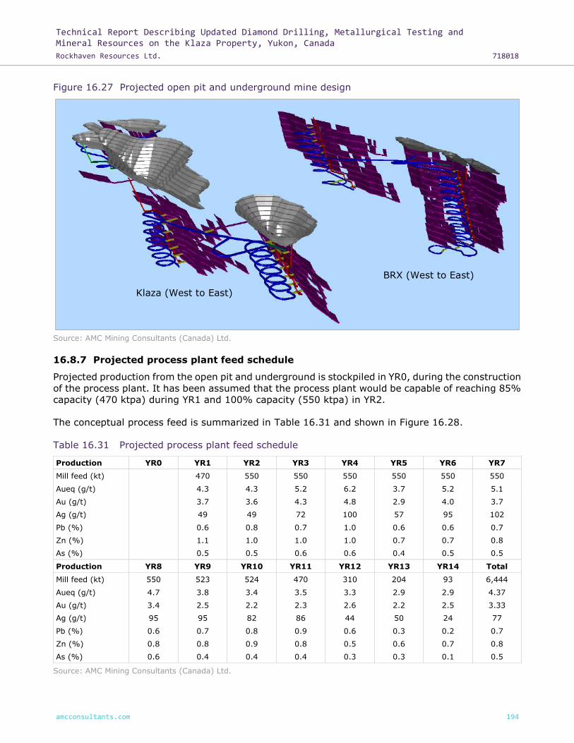
Technical Report Describing Updated Diamond Drilling, Metallurgical Testing and Mineral Resources on the Klaza Property, Yukon, Canada
Rockhaven Resources Ltd. 718018
amcconsultants.com 194
Figure 16.27 Projected open pit and underground mine design
Source: AMC Mining Consultants (Canada) Ltd.
16.8.7 Projected process plant feed schedule
Projected production from the open pit and underground is stockpiled in YR0, during the construction
of the process plant. It has been assumed that the process plant would be capable of reaching 85%
capacity (470 ktpa) during YR1 and 100% capacity (550 ktpa) in YR2.
The conceptual process feed is summarized in Table 16.31 and shown in Figure 16.28.
Table 16.31 Projected process plant feed schedule
Production YR0 YR1 YR2 YR3 YR4 YR5 YR6 YR7
Mill feed (kt) 470 550 550 550 550 550 550
Aueq (g/t) 4.3 4.3 5.2 6.2 3.7 5.2 5.1
Au (g/t) 3.7 3.6 4.3 4.8 2.9 4.0 3.7
Ag (g/t) 49 49 72 100 57 95 102
Pb (%) 0.6 0.8 0.7 1.0 0.6 0.6 0.7
Zn (%) 1.1 1.0 1.0 1.0 0.7 0.7 0.8
As (%) 0.5 0.5 0.6 0.6 0.4 0.5 0.5
Production YR8 YR9 YR10 YR11 YR12 YR13 YR14 Total
Mill feed (kt) 550 523 524 470 310 204 93 6,444
Aueq (g/t) 4.7 3.8 3.4 3.5 3.3 2.9 2.9 4.37
Au (g/t) 3.4 2.5 2.2 2.3 2.6 2.2 2.5 3.33
Ag (g/t) 95 95 82 86 44 50 24 77
Pb (%) 0.6 0.7 0.8 0.9 0.6 0.3 0.2 0.7
Zn (%) 0.8 0.8 0.9 0.8 0.5 0.6 0.7 0.8
As (%) 0.6 0.4 0.4 0.4 0.3 0.3 0.1 0.5
Source: AMC Mining Consultants (Canada) Ltd.
Klaza (West to East)
BRX (West to East)

Technical Report Describing Updated Diamond Drilling, Metallurgical Testing and Mineral Resources on the Klaza Property, Yukon, Canada
Rockhaven Resources Ltd. 718018
amcconsultants.com 195
Figure 16.28 Projected process plant feed
Source: AMC Mining Consultants (Canada) Ltd.

Technical Report Describing Updated Diamond Drilling, Metallurgical Testing and Mineral Resources on the Klaza Property, Yukon, Canada
Rockhaven Resources Ltd. 718018
amcconsultants.com 196
17 Recovery methods
17.1 Process Flow Sheet
The currently perceived flowsheet is summarized in Figure 17.1 below. Processing of the
pre-concentrate mirrors that described in the 2016 PEA, except for the possible option of direct sale
of the sulphide concentrate.
Figure 17.1 Summarized Klaza Project process flowsheet
Source: Blue Coast Metallurgy Ltd.
Since the 2016 PEA, gravity pre-concentration has been included to reduce the tonnage feeding the
grinding and flotation circuits by approximately 50%. Run-of-mine materials from Western, Central
and Eastern BRX, as well as Central Klaza, would be crushed to 9.5 mm and fines screened out at
1.4 mm. Gravity pre-concentration, which could be by jigging or dense media separation, would be

Technical Report Describing Updated Diamond Drilling, Metallurgical Testing and Mineral Resources on the Klaza Property, Yukon, Canada
Rockhaven Resources Ltd. 718018
amcconsultants.com 197
conducted on the coarse fraction. This would yield a high grade concentrate which would be blended
with the fines and fed to the grinding circuit.
Pre-concentration tails, a desulphurized crusher product sized at 1.4 – 9.5 mm and comprising
roughly 50% of the run of mine tonnage, would be stored.
As before, after primary grinding, sequential rougher and cleaner flotation would produce a gold-rich
lead concentrate and a zinc product. The lead concentrate would undergo intensive leaching to
extract most of the gold prior to be being shipped to market. The gold extracted through this leach
would be upgraded to doré. The zinc product is poorer in gold and would be shipped directly.
The zinc circuit tails would be subjected to flotation of the gold-bearing sulphides. These would be
a blend of pyrite and arsenopyrite, the precise mix of which would depend on whether the
concentrate was to be processed on-site using pressure hydrometallurgy or sold to a third party.
Material from Eastern BRX would be treated separately in a process integrating flotation with
concentrate direct cyanidation and using, except for a single regrind mill, equipment already in
place for the rest of the project. No pressure hydrometallurgy would be needed in treating Eastern
BRX and only doré would be produced for sale.
The final flotation tails, comprising about 40% of the original mill feed, would be stored in a tailings
impoundment.
17.2 Tailings management
This report discloses the results of an updated Mineral Resource estimate incorporating 2016 and
2017 drilling results, and additional metallurgical studies. It is an update to those Mineral Resources
and metallurgical results reported in a PEA Technical Report prepared by AMC for Rockhaven in
February 2016. The results of the 2016 PEA Technical Report described herein are based on the
earlier Mineral Resource model, and the studies related to the PEA have not yet been updated to
consider the new Mineral Resource model and the modified metallurgical treatment scheme.
This section was taken from the NI 43-101 technical report titled “Technical Report and PEA for the
Klaza Au-Ag Deposit, Yukon Canada for Rockhaven Resources Ltd.” dated 26 February 2016. This
section remains unchanged and is included for completeness and continuity.
17.2.1 General
The principal design objectives for tailings management are protection of the regional groundwater
and surface waters both during operations and in the long-term (after closure), and to achieve
effective reclamation at mine closure. The design of the tailings management strategy has taken
into account the following requirements:
• Permanent, secure and total confinement of all solid waste materials within engineered
disposal facilities.
• Control, collection and removal of free-draining liquids from the tailings during operations for
recycling as process water to the maximum practical extent.
• Collection and diversion of water from upstream of the tailings storage sites, open pits, and
mill site areas during operations.
• The inclusion of monitoring features for all aspects of the facility to verify performance goals
are achieved and design criteria and assumptions are met.
• Staged development of the facility over the life of the project.

Technical Report Describing Updated Diamond Drilling, Metallurgical Testing and Mineral Resources on the Klaza Property, Yukon, Canada
Rockhaven Resources Ltd. 718018
amcconsultants.com 198
The tailings management strategy has been developed to manage the different tailings streams in
separate facilities based on the tailings geochemical properties. Two tailings streams requiring
disposal will be produced:
• Hydromet residue
• Flotation tailings
The hydromet residue will be managed in a separate facility sized to contain the production schedule
volume. The flotation tailings will be managed using a surface facility with a containment structure
until approximately Year 6, when the open pits will be available to receive tailings. Detailed
descriptions of the facilities are provided in the section below.
The Hydromet Residue and initial Flotation Tailings Facility layouts are shown in Figure 17.2.
Figure 17.2 Hydromet Residue and Flotation Tailings Facilities overall layout
Source: Knight Piésold.

Technical Report Describing Updated Diamond Drilling, Metallurgical Testing and Mineral Resources on the Klaza Property, Yukon, Canada
Rockhaven Resources Ltd. 718018
amcconsultants.com 199
17.2.2 Hydromet Residue Storage Facility
The Hydromet Residue Storage Facility is optimally positioned adjacent to the plant and directly up
gradient from the Flotation Tailings Facility. This location was the most viable and practical based
on a number of economic and operational factors.
The hydromet residues are expected to be relatively stable, but high in arsenic and will be contained
within a lined engineered containment to allow for the tailings solids to settle and consolidate behind
a confining embankment.
A foundation drainage system will be constructed to collect any seepage and dewater any potential
groundwater seeps in the foundation. The foundation drains will comprise a spine drain configuration
of Corrugated Polyethylene Tubing (CPT) pipes installed in a gravelly sand matrix. The foundation
drainage system will flow to a collection manhole at the downstream toe of the tailings embankment,
where it will be pumped into the Flotation Tailings Facility. Flow rates and water quality in the
foundation drain will be monitored to ensure the integrity of the liner system.
The downstream method of embankment construction is proposed. The embankment is planned
with a 2.5-horizontal to 1-vertical (2.5H:1V) upstream slope, and a 2.5H:1V downstream slope.
Development will be in two stages as follows:
• Stage 1 – Elevation 1,225 m – Start-up (tailings storage Years 1 to 5).
• Stage 2 – Elevation 1,230 m - Constructed in Year 5 (tailings storage Years 6 to 14).
The embankment will be constructed and operated as a geosynthetic-faced rockfill dam. The
embankment will comprise a rockfill dam with a geosynthetic liner system installed on the upstream
face of the dam and extended over the entire basin area. The impoundment basin will be re-graded
so that the floor of the impoundment drains towards the north and the side slopes of the facility will
be re-graded to a maximum slope of 3H:1V. The lined area of the facility is 65,000 m2.
The Stage 2 embankment configuration features a dam roughly 20 m high and 400 m in length,
with a total fill volume estimated to be 260,000 m3. Waste rock will be used for the majority of the
construction, as the short overhaul from the waste rock dump will cost less than constructing the
dam with local borrow material. A thin bedding layer will be placed over the rough-graded surface
to prepare the surface to receive geosynthetics.
Minimizing water loss is a key aspect of the conceptual design. This will involve keeping the
supernatant pond surface area to a minimum, controlling the wet beach area, capturing runoff, and
recycling seepage water. The facility is situated up-gradient from the Flotation Tailings Facility
allowing for a simple, safe and environmentally sound site water management plan.
Tailings will be deposited by gravity around the perimeter of the facility by means of sequential
discharge through a series of spigot offtakes using subaerial / subaqueous deposition techniques.
Reclaim water from the supernatant pond will be recycled to the mill from a floating barge located
in the southern portion of the facility closest to the plant site.
Closure of the facility will involve a progressive capping of the facility with a waste rock and
overburden blanket.
17.2.3 Flotation Tailings Facility
The Flotation Tailings Facility is optimally positioned downgradient and adjacent to the plant. This
location was the most viable and practical based on a number of economic and operational factors.

Technical Report Describing Updated Diamond Drilling, Metallurgical Testing and Mineral Resources on the Klaza Property, Yukon, Canada
Rockhaven Resources Ltd. 718018
amcconsultants.com 200
The flotation tailings are expected to be relatively benign and will be contained within a solids
retention facility to allow for the tailings solids to settle and consolidate behind a confining
embankment.
A foundation drainage system will be constructed to collect any seepage and dewater any potential
groundwater seeps in the foundation. The foundation drains will comprise a spine drain configuration
of Corrugated Polyethylene Tubing (CPT) pipes installed in a gravelly sand matrix. This drainage
system will enhance the consolidation of the tailings solids by providing two-way drainage of the
tailings deposit. The foundation drainage system will flow to a collection manhole at the downstream
toe of the tailings embankment, where it will be pumped back to the TSF. Flow rates and water
quality in the foundation drain will be monitored to ensure the integrity of the liner system.
The downstream method of embankment construction is proposed. The embankment is planned
with a 2.5H:1V upstream slope, and a 2.5H:1V downstream slope. Development will be staged in
two year increments as follows:
• Stage 1 – Elevation 1,203 m – Start-up (tailings storage Years 1 and 2).
• Stage 2 – Elevation 1,207 m - Constructed Year 2 (tailings storage Years 3 and 4).
• Stage 3 – Elevation 1,211 m - Constructed Year 4 (tailings storage Years 5 and 6).
The embankment will be constructed and operated as a water-retaining structure. The embankment
will be comprised of a zoned structure having a low-permeability core zone with appropriate filter
and transition zones to prevent downstream migration of the tailings. The core zone will be keyed
into the low- permeability overburden foundation or bedrock.
The Stage 3 embankment configuration features a dam roughly 25 m high and 1 km in length, with
a total fill volume estimated to be 952,000 m3. Waste rock will be used for the majority of the
construction, as the short overhaul from the waste rock dump will cost less than constructing the
dam with local borrow material. Core zone and drainage materials will be sourced from local borrow
areas and the placer-mining workings.
Minimizing water loss is a key aspect of the conceptual design. This will involve keeping the
supernatant pond surface area to a minimum, controlling the wet beach area, capturing runoff, and
recycling seepage water. The facility is down-gradient from all of the other mine site facilities,
allowing for a simple, safe and environmentally sound site water management plan.
Tailings will be deposited by gravity around the perimeter of the facility by means of sequential
discharge through a series of spigot offtakes using subaerial deposition techniques. Reclaim water
from the supernatant pond will be recycled to the mill from a floating barge located in the southern
portion of the facility closest to the plant site.
Closure of the facility will involve a progressive capping of the facility with a waste rock and
overburden blanket.
17.2.4 Open pit flotation tailings disposal
The flotation tailing deposition strategy will be modified in Years 7 to 14 to take advantage of the
available space for tailings solids storage in the mined-out Klaza open pits. The mining sequence
has indicated that the Open Pits designated Klaza 1 and Klaza 2 will be available for tailings storage
starting in Year 7.
The filling capacity of the Klaza 1 and Klaza 2 open pits was evaluated and the results are
summarized as follows:

Technical Report Describing Updated Diamond Drilling, Metallurgical Testing and Mineral Resources on the Klaza Property, Yukon, Canada
Rockhaven Resources Ltd. 718018
amcconsultants.com 201
• Open Pit Klaza 1 - Elevation at haul road daylight 1,290 m, storage capacity = 670,000 m3
(871,000 tonnes).
• Open Pit Klaza 2 – Elevation at haul road daylight 1,320 m, storage capacity = 2,100,000 m3
(2,730,000 tonnes).
The pits would be filled with tailings to the pit rim and supernatant water decanted to the Flotation
Tailings Facility via a reclaim piping system. Excess storm-water flows would be routed along the
haul road collection ditches to the Flotation Tailings Facility for use in the process.
Closure of the pits involves capping the final tailings surface with a waste rock and overburden
blanket
17.2.5 Water management
The key facilities for the water management plan are:
• Open pits.
• Underground mine dewatering.
• Mill (including fresh and process water tanks).
• Tailings storage facility (TSF).
• Diversion and water management structures.
• Fresh water supply.
• Sediment and erosion control measures for the facilities.
The water management strategy utilizes water within the project area to the maximum practical
extent. The plan involves collecting and managing site runoff from disturbed areas and maximizing
the recycle of process water. Site runoff water will be stored on site within the Flotation Tailings
Facility. The water supply sources for the project are as follows:
• Precipitation runoff from the mine site facilities.
• Water recycle from the tailings supernatant ponds.
• Groundwater from open pit and underground dewatering and depressurization.
• Fresh water supply from the Klaza River.
• Treated black and grey water, in small quantities, from the camp.
An overall high-level average monthly site water balance assessment was carried out to determine
the preliminary water management strategy and process makeup water requirements for the
project.
The results from the water balance modelling are summarized below:
• There will be no surface water discharge from the tailings facilities to the environment during
operations.
• Under average precipitation conditions the site will operate in a water-deficit condition with
the need for additional makeup water.
• The average annual runoff into the hydromet and flotation tailings facilities will be
approximately 67,000 m3 per year, which includes runoff from undisturbed catchments, TSF
beaches, and ponds.
• Pit runoff and pit dewatering contributes on average 60,000 m3 of water per year under
average precipitation conditions.
• Mine dewatering provides approximately 50,000 m3 annually.

Technical Report Describing Updated Diamond Drilling, Metallurgical Testing and Mineral Resources on the Klaza Property, Yukon, Canada
Rockhaven Resources Ltd. 718018
amcconsultants.com 202
The average volume of water retained in the tailings voids, and hence not available for water
recycle to the processing plant is approximately 250,000 m3 annually. This volume will be
replaced by pumping from the Klaza River at a rate of 685 m3/d.
• The potable water requirement is approximately 7,000 m3 annually.
• Site road watering utilizes approximately 14,000 m3 annually in the summer months.
• Underground water consumption for the drills and washdown consumes 38,000 m3 annually.

Technical Report Describing Updated Diamond Drilling, Metallurgical Testing and Mineral Resources on the Klaza Property, Yukon, Canada
Rockhaven Resources Ltd. 718018
amcconsultants.com 203
18 Project infrastructure
This report discloses the results of an updated Mineral Resource estimate incorporating 2016 and
2017 drilling results, and additional metallurgical studies. It is an update to those Mineral Resources
and metallurgical results reported in a PEA Technical Report prepared by AMC for Rockhaven in
February 2016. The results of the 2016 PEA Technical Report described herein are based on the
earlier Mineral Resource model, and the studies related to the PEA have not yet been updated to
consider the new Mineral Resource model and the modified metallurgical treatment scheme.
This section was taken from the NI 43-101 technical report titled “Technical Report and PEA for the
Klaza Au-Ag Deposit, Yukon Canada for Rockhaven Resources Ltd.” dated 26 February 2016. This
section remains unchanged and is included for completeness and continuity.
18.1 Surface infrastructure
18.1.1 Mine offices
The mine offices will be an assembly of standard construction industry grade, portable trailers. The
trailer complex will provide for a perimeter of offices, a common area in the center, meeting rooms,
lunch rooms, and training rooms. The structure will be insulated to suit the climate and tie into the
site distribution systems for heating and power.
The offices would be particularly suitable as construction offices for the process plant and such use
would reduce the indirect construction cost of the plant.
18.1.2 Mine dry
The mine dry will also be an assembly of construction industry grade, portable trailers. Space for
200 lockers and baskets will be provided along with showers and laundry facilities. The mine dry
will be connected to the offices. Personnel will be transported from the dry directly to the mine
portals.
18.1.3 Sewage treatment
Sewage treatment at the mine site will consist of a vacuum truck removing sewage from various
locations at the site and delivering to a central facility near the process plant. Grey water will be
handled as part of the tailings stream.
18.1.4 Garbage incineration
Garbage will be sorted into various categories such as clean wood, metals, recyclables, and mixed.
Clean wood and paper may be burnt at site in accordance with the operating permit. All other
garbage will be removed from site to the local municipality and disposed of in accordance with best
environmental practice.
18.1.5 Power
18.1.5.1 Generation
A trade-off study was conducted to investigate providing electric power using diesel generators or
grid power from the territorial utility. The results indicate that grid electrical power provides more
value to the project over the life of the mine.
The diesel generation option would require generators with spare capacity and fuel tanks. The capital
cost of the tanks and generators was estimated from public pricing and unit rates and benchmarked
against other projects. Fuel was assumed to be trucked in from Edmonton. The electrical
consumption over the life of the mine was estimated and used to prepare an operating cost. The

Technical Report Describing Updated Diamond Drilling, Metallurgical Testing and Mineral Resources on the Klaza Property, Yukon, Canada
Rockhaven Resources Ltd. 718018
amcconsultants.com 204
discounted (5%) total cost (capital plus operating) of power over the life of the mine using diesel
generators was estimated to be C$210M.
The grid power option would require a transmission power line to be constructed from Carmacks to
the mine-site along the existing Mount Nansen road and upgraded placer access roads (see Figure
18.1). The cost of the power line was estimated using unit rates, budget quotations, and published
productivities. It was also benchmarked against other projects. A unit cost for electricity was
obtained from the publications of the power utility. This cost was then discounted over the life of
the mine using the same assumptions as the generator option. The discounted (5%) total cost
(capital plus operating) of power over the LOM using the local grid was estimated to be C$100M.
The key power assumptions were:
• Discount rate of 5%.
• Overall cost of utility power C$0.105 per kW-hr (includes allowance for cost of the transmission
line).
• Cost of diesel at C$1.00 per litre.
• Utility capacity exists (or will exist) to supply the mine and process plant.
These results indicate that there is a major economic benefit using electrical power supplied from
the local grid. The transmission line would be provided by the utility and paid off over the LOM as a
surcharge on the unit cost of power.
18.1.5.2 Distribution
The main electrical supply will consist of a 73 km, 138 kV transmission line from the territorial power
grid at Carmacks. The main feeders will be brought to the sub-station and primary disconnect near
the process plant, as this is the location of the largest power load.
Lower voltages tapped from the sub-station will then be distributed via buried cables to the mine
portals, oxygen plant, and open pit mine complex.
Each of the two underground mines will have a local sub-station and disconnect that further reduces
the voltage down to 4,160 V for the mine supply. Buried cables will carry the power to surface
facilities such as exhaust fans. Main feeder cables will distribute power down the declines.
At each mining level there will be a disconnect switch and junction box that will allow a portable
sub-station to provide power on the level. Portable sub-stations will be moved between levels to
support mining activities, with lower voltage tailing cables being moved along with them. These
sub-stations will provide ground fault interruption and voltage reduction to supply mobile equipment
and lighting.
Permanent sub-stations will be used for stationary power loads such as mine dewatering pump
stations or maintenance shops, with a centrally located sub-station using shorter distribution
networks to provide efficient local supply.
18.1.6 Water supply
Water for the mine site and processing plant will be supplied from the Klaza river. Knight Piésold
(KP) has estimated 685 m3/d of make-up water is required. The water will be pumped using a 50 HP
pump housed near the river via a heated and insulated 0.8 km pipeline to the processing plant for
treatment. A modular filtration unit will be used to clean the water for industrial use. Potable water
will be supplied via a potable water treatment plant.

Technical Report Describing Updated Diamond Drilling, Metallurgical Testing and Mineral Resources on the Klaza Property, Yukon, Canada
Rockhaven Resources Ltd. 718018
amcconsultants.com 205
18.1.7 Maintenance shop and warehousing
The underground mines will be supported by a centrally located maintenance facility near the offices,
a heated warehouse, and a cold storage warehouse. The maintenance shop will consist of a
pre-engineered steel structure placed on a slab cast on grade. The building will have three
maintenance bays and one wash bay. Fast-acting vehicle doors will help prevent the loss of heat
from the building during the winter season.
The shop will be sufficient to handle larger, longer, and more complex maintenance repairs that will
be needed by the underground mining operation. Smaller repairs and routine maintenance will be
handled underground.
The maintenance shop will provide administration space and will be attached to the heated
warehouse. Both structures will be fitted with sprinklers and fire alarms. The fire water pumps will
be installed in the wash bay mechanical room.
The maintenance shop will be equipped with carbon monoxide detection equipment that will activate
the high flow ventilation requirement for the shop. Indirect fired radiant heaters will heat the shop
floor and allow for the quick de-icing of equipment. Space for tools and the maintenance asset
management system will also be provided. The waste oil storage facility will be placed near the
shop.
The heated warehouse will provide enough inventory space for daily operations as well as critical
maintenance spares. Stock levels for routine and minor maintenance will be set at a one week
supply, which will provide enough buffer given the direct access to the mine site. Other major stock
items for planned maintenance will be brought in via the Mount Nansen road.
18.1.8 Surface mobile equipment
The mine will designate an emergency vehicle (ambulance) for evacuation to medical care via the
access road. A fire truck will also be located near the ambulance. A vacuum truck, flat deck, and
mechanics vehicles will be also be required.
A telehandler and small forklift for moving equipment and supplies around the processing plant and
warehouse will be provided.
A small 35 tonne crane for maintenance tasks in the processing plant, surface handling, and other
tasks can be procured with an operator on rent as needed for shutdown maintenance tasks. The
low usage of such equipment would not necessitate having a permanent qualified operator on site.
18.1.9 Accommodations
The work force will be encouraged to live in the village of Carmacks and a daily bus service will be
provided to drive them 73 km to the mine and back. There is no allowance for a mine camp in the
project estimates. Kitchen facilities will be available for dispensing tea and coffee in the mine offices.
Washrooms and lockers have been allowed for at the main office. Carmacks has a current population
of approximately 450. AMC has estimated a total site workforce of 255 people and 90 open pit
contractors. Approximately 185 staff on site and 60 contractors are projected during normal
production, including management and technical staff.
18.1.10 Fire detection and suppression systems
Each of the mine ventilation systems will be provided with an ethyl mercaptan (stench gas) system
(activated manually or remotely) in order to warn underground personnel in the event of an
emergency. Radio contact via the leaky feeder system provides an alternative method of

Technical Report Describing Updated Diamond Drilling, Metallurgical Testing and Mineral Resources on the Klaza Property, Yukon, Canada
Rockhaven Resources Ltd. 718018
amcconsultants.com 206
communication. The supply, exhaust, and heater fans can be shut down or adjusted to assist with
fire control systems in the mine. A fire-water supply tank, fire pumps, and distribution system will
feed hydrants and Y-fittings in the surface buildings to provide fire-fighting capability to the process
plant, mine offices, shops, and mine dry. Buildings (particularly warehouses and shops) will be fitted
with alarms and equipped with sprinklers.
18.1.11 Roads
A network of light vehicle roads will be provided to keep personnel vehicles separate from the open
pit and underground mine haul traffic. These roads will be constructed in accordance with applicable
permafrost design requirements. Generally they will have a one metre thick crushed rock layer, a
five metre wide crown, and sloping shoulders on a 3:1 gradient to control snow accumulation.
The final section of the public road to the mine site will be refurbished (approximately 13 km),
however the public road to Carmacks will be maintained by the local rural municipality or territory.
The road shoulders and crown must be maintained in good condition as the entire work-force at the
plant is intended to reside at Carmacks and commute daily. Figure 18.1 shows the Mount Nansen
road from Carmacks to the Klaza project.
Figure 18.1 Klaza project access road
Source: Archer, Cathro & Associates (1981) Limited.
18.1.12 Waste water
Underground mine water from operations, surface water from the open pits, and grey water from
the office and mine dry will be routed via dual wall heat-traced HDPE piping systems, partially or
completely buried, to the plant for processing as part of the tailings system.

Technical Report Describing Updated Diamond Drilling, Metallurgical Testing and Mineral Resources on the Klaza Property, Yukon, Canada
Rockhaven Resources Ltd. 718018
amcconsultants.com 207
18.1.13 Explosives
Explosives will be transported into the underground mines and two shifts of capacity stored in
simple, secure underground facilities. The majority of explosives will be stored on surface as part
of the open pit mine operations. The underground mines will continue to use the open pit explosives
facilities when the open pit phase of the project is completed.
18.1.14 Open pit
The open pit facilities will be provided by the contractor and will consist of offices, maintenance
shop, warehouse, and the explosives magazine. Part of these facilities could be used for the longer
term underground operation and an allowance for this arrangement has been included in the capital
cost estimate for surface infrastructure.
A general layout of the surface infrastructure, process plant, offices, roads, waste dumps and
stockpiles, and the TSF is shown in Figure 18.2.
Figure 18.2 General layout of the surface infrastructure for Klaza
Source: AMC Mining Consultants (Canada) Ltd.
18.2 Underground infrastructure
Underground mine services will include lunchrooms, a small maintenance shop for minor and urgent
repairs, fuel and lubricant storage, and small explosives and caps magazines.
18.2.1 Lunchrooms
The lunchrooms will provide a clean heated space with potable water, tables, and chairs. They will
also be used as mine refuge areas. The mine rescue team will be able to use the space for training

Technical Report Describing Updated Diamond Drilling, Metallurgical Testing and Mineral Resources on the Klaza Property, Yukon, Canada
Rockhaven Resources Ltd. 718018
amcconsultants.com 208
and to store equipment and supplies. A lunchroom will be provided in each of the four main mining
areas.
18.2.2 Workshop
A single bay maintenance shop with a jib crane will be provided in each mine. The intent of this bay
is to enable routine tasks such as lubrication and changing of filters, and minor repairs to keep the
equipment in a serviceable condition and return it quickly into service. Any significant maintenance
will be conducted on surface in the main workshop.
18.2.3 Fuel and lube bay
A fuel and lubrication area will be provided underground in each mine. While most fueling will be
conducted via tankers from surface, some storage via totes will be provided underground. Storage
will also be provided for lubricants and waste oil. A small location equipped with fire doors, fire
detection, and air operated pumps will dispense the products near the maintenance bay.
18.2.4 Explosives magazine
The explosives magazine located in each mine will be a few rounds deep and equipped with a
lockable door and wooden benches covered with rubber matting. The space will be ventilated and
kept cool. The intent is to provide a small stockpile of detonators, cord, and high velocity explosive
for daily task specific activities. Explosives handling and delivery from surface will be accomplished
using mobile loading equipment drawing from the surface magazine.
18.2.5 Compressed air
Compressed air will be supplied by mobile electric compressors. These will be situated on active
levels and at the maintenance bay. The compressors will be relocated to active mining levels as
needed.
18.2.6 Service water
Mine water will be supplied via a four inch steel line down the declines that will be installed as the
decline progresses. At required levels, pressure reducing and isolation valves will be installed to
maintain the system at operating pressures. A two inch distribution system of steel pipe, together
with hoses will be laid out on the operating levels.
18.2.7 Communications
Underground telecommunications will be provided by a conventional leaky feeder system strung
down the decline and feeding the operating levels.
18.2.8 Dewatering
The mine dewatering system will consist of staged 50 HP submersible dirty water pumps at
nominally 60 m vertical intervals. Each sump will have two pumps to provide continual redundancy.
A six inch steel line will carry pumped water from each mine and direct it to the process water
treatment facility.
Mine water is largely expected to be a product of the mining activities (drilling and washing the face
and muck piles). The six inch standard weight steel line is sized so that, with two pumps, a
significant increase to the dewatering volume could be handled; with one pump, a flow that results
in a carrying velocity in the line is still generated.
Dewatering facilities will be installed as the mine development proceeds and pumps will be relocated
as areas are abandoned and the pumps are no longer required. Carrying cost of the pumps is
Technical Report Describing Updated Diamond Drilling, Metallurgical Testing and Mineral Resources on the Klaza Property, Yukon, Canada
Rockhaven Resources Ltd. 718018
amcconsultants.com 209
presumed to be part of sustaining capital in later years and only a portion of the dewatering system
cost is capitalized in this analysis.
18.2.9 Mine escape and rescue
Portable refuge stations will be located appropriately relative to operating levels. Lunchrooms near
the maintenance area will also serve as refuge stations. Self-rescue storage will be provided in the
lunchrooms as well as first aid kits at the refuge stations.
Main egress is provided by the declines and a second means of egress via the ladders in the vent
raises.
18.3 Logistics
The Klaza mine location does not pose significant logistical challenges that may affect the movement
of people to and from the site, supplies inbound, and concentrates outbound. There is an existing
road to the site. This entire road except for the final 13 km to the site is maintained by the Yukon
department of highways year-round. Apart from capital and emergency spares, processing reagents
and fuel, most necessary materials and supplies can be brought to site as required during the year.
A warehouse and cold storage will be constructed to accommodate any critical items.
18.4 Personnel movement
Personnel will travel to and from Carmacks on daily buses. The closest large airport is Whitehorse
International Airport located 175 km south of Carmacks. The airport has capability for large and
small planes and is serviced with scheduled daily flights to larger centres in Canada. The village of
Carmacks has a small municipal airfield that is used for emergency services such as fire-fighting,
and for private aircraft.
18.5 Inbound freight
Freight will be shipped in from Carmacks via the main access road. Public all-weather road access
to tidewater is available at Skagway (5 hours) and Prince Rupert (20 hours). Inland freight access
is also available from Edmonton. No special or unusual freight handling requirements are expected.
Laydown areas will be provided on surface as well as cold storage and in the heated warehouse.
18.6 Outbound concentrate
An area for loading, unloading and servicing concentrate and other trucks will be established at the
plant site. Concentrate will be loaded directly into steel boxes for shipment to markets via the main
road access. Concentrate containers will be handled by forklift. Concentrate will not be stockpiled
at site but will be transported as soon as a container is full.
18.7 Fuel storage
Fuel storage will consist of two tanks that will have the capacity to support two months consumption
at peak production. The tank system will be enclosed by a lined berm of sufficient capacity to contain
110% of the contents of a full tank in the event of a major leak or spillage. Fuel will be trucked to
site on a year-round basis.
18.8 Tailings disposal
Tailings disposal is discussed in Section 17.

Technical Report Describing Updated Diamond Drilling, Metallurgical Testing and Mineral Resources on the Klaza Property, Yukon, Canada
Rockhaven Resources Ltd. 718018
amcconsultants.com 210
18.9 Stockpiles
No large mineralized rock stockpiles are anticipated over the life of the mine. ROM stockpiles will be
located in areas that will allow control of potential run-off. The stockpiles will be affected by
permafrost and, as such, these will be kept to a minimum. Material from the mine will be loaded
from the ROM pad onto a conveyor and fed into the storage bin located at the process plant.

Technical Report Describing Updated Diamond Drilling, Metallurgical Testing and Mineral Resources on the Klaza Property, Yukon, Canada
Rockhaven Resources Ltd. 718018
amcconsultants.com 211
19 Market studies and contracts
This report discloses the results of an updated Mineral Resource estimate incorporating 2016 and
2017 drilling results, and additional metallurgical studies. It is an update to those Mineral Resources
and metallurgical results reported in a PEA Technical Report prepared by AMC for Rockhaven in
February 2016. The results of the 2016 PEA Technical Report described herein are based on the
earlier Mineral Resource model, and the studies related to the PEA have not yet been updated to
consider the new Mineral Resource model and the modified metallurgical treatment scheme.
This section was taken from the NI 43-101 technical report titled “Technical Report and PEA for the
Klaza Au-Ag Deposit, Yukon Canada for Rockhaven Resources Ltd.” dated 26 February 2016. This
section remains unchanged and is included for completeness and continuity.
19.1 Metal prices
The project NSR values have been generated using the metal prices shown in Section 22.2.
For the PEA it is assumed that the metal prices will remain stable over the project life.
19.2 Product grades and volumes
The NSR values were developed using the grades, recoveries, and production volumes described in
Section 16.
19.3 Marketing
19.3.1 Overview
Initial metallurgical tests showed elevated levels of penalty elements in the forecast lead and zinc
concentrates. In addition, the low levels of zinc in zinc concentrates and the high levels of gold in
lead concentrates were seen to be potentially difficult in the marketing of both concentrates.
Although this is a PEA based on Inferred Mineral Resources, Rockhaven decided to undertake an
additional degree of research regarding the marketability of the concentrates. The high percentage
of precious metal reporting to the concentrates would potentially impact marketability and lead to
inclusion of the Acacia leach process. In addition, a concerted effort was made to reduce the
potential deleterious elements present in the concentrates and, thereby, improve the marketability.
Test results from the additional research showed a significant lowering of concentrate impurities,
an increase in the base metal grades of the concentrates and a shift of the recovered gold from the
lead concentrate to doré.
While HMH has investigated possible markets and potential terms, no detailed market study has
been undertaken at this stage of the project.
It is envisaged that the gold-rich zinc concentrate would be sold primarily to smelters in Asia.
The lead concentrate could also potentially be sold to smelters in Asia or other offshore smelters.
If sold to a North American smelter, transportation costs may be reduced, but it is reasonable to
anticipate that these savings, if any, might need to be shared with the smelter.
Both lead and zinc concentrates would be expected to incur some penalties for impurities.

Technical Report Describing Updated Diamond Drilling, Metallurgical Testing and Mineral Resources on the Klaza Property, Yukon, Canada
Rockhaven Resources Ltd. 718018
amcconsultants.com 212
19.3.2 Lead concentrate treatment terms
Treatment terms for the lead and zinc concentrates used to estimate the NSR values have been
advised by HMH and are shown in Table 19.1 and Table 19.2 respectively.
Table 19.1 Projected lead concentrate terms
Treatment terms Value
Gold payment terms (% of contained metal in concentrate) 95%
Minimum deduction from gold grade 1.0 g
Silver payment terms (% of contained metal in concentrate) 95%
Minimum deduction from silver grade 50 g
Lead payment terms (% of contained metal in concentrate) 95%
Minimum deduction from lead concentrate grade 3 units
Lead Concentrate treatment charge $205/dmt
Deduction for penalty elements (per tonne of concentrate) $130.00/dmt
Price participation-threshold price per tonne of lead metal in concentrate $1,700/mt
Price participation for each dollar the metal price is below threshold price $0.065/dmt
Price participation for each dollar the metal price is above threshold price $0.065/dmt
Gold refining charge (% of gold price) applied to payable gold metal 1.7%
Silver refining charge (% of silver price) applied to payable silver metal 9.5%
Source: H. M. Hamilton & Associates Inc.
19.3.3 Zinc concentrate treatment terms
Table 19.2 Projected zinc concentrate terms
Treatment terms Value
Gold payment terms (% of contained metal in concentrate) 70%
Initial deduction from gold grade 1.0 g
Silver payment terms (% of contained metal in concentrate) 70%
Initial deduction from silver grade 3 oz
Zinc payment terms (% of contained metal in concentrate) 85%
Minimum deduction from zinc concentrate grade 8 units
Zinc Concentrate treatment charge $170/dmt
Deduction for penalty elements (per tonne of concentrate) $27.00/dmt
Price participation threshold price per tonne of zinc metal in concentrate $1,000/mt
Price participation for each dollar the metal price is below threshold price $0.10/dmt
Price participation for each dollar the metal price is above threshold price $0.10/dmt
Source: H. M. Hamilton & Associates Inc.
19.3.4 Transportation
19.3.4.1 Overview
Deliveries would be in containers to Asian ports, most likely to Japan, South Korea or Northern
China. The containers would be trucked from the mine site to the port in Skagway, Alaska, barged
from Skagway to Seattle, Washington, and then transferred to a container vessel for shipment to
Asia. These deliveries are assumed to be delivered to the Asian port with the cost of the freight and
insurance (CIF) for the shipper’s account.

Technical Report Describing Updated Diamond Drilling, Metallurgical Testing and Mineral Resources on the Klaza Property, Yukon, Canada
Rockhaven Resources Ltd. 718018
amcconsultants.com 213
19.3.4.2 Total transportation costs
On the basis of a moisture content of 8% and using a C$ : US$ exchange rate of 0.75:1, the total
transportation cost is projected to be US$154.56 per dry metric ton.
19.3.5 Net smelter / mine returns – summary
NSR values are summarized in Table 19.3.
Table 19.3 Projected NSR values for concentrates
NSR Net Return FOB Mine
Lead concentrates (US$/dmt concentrate) US$2,970.77 US$2,807.01
Zinc concentrates (US$/dmt concentrate) US$1,208.61 US$1,050.14
Lead concentrates (US$/t of mineralized material) US$30.30
Zinc concentrates (US$/t of mineralized material) US$18.40
Total (US$/t of mineralized material) US$48.70
Source: H. M. Hamilton & Associates Inc.

Technical Report Describing Updated Diamond Drilling, Metallurgical Testing and Mineral Resources on the Klaza Property, Yukon, Canada
Rockhaven Resources Ltd. 718018
amcconsultants.com 214
20 Environmental studies, permitting, and social or community impact
This report discloses the results of an updated Mineral Resource estimate incorporating 2016 and
2017 drilling results, and additional metallurgical studies. It is an update to those Mineral Resources
and metallurgical results reported in a PEA Technical Report prepared by AMC for Rockhaven in
February 2016. The results of the 2016 PEA Technical Report described herein are based on the
earlier Mineral Resource model, and the studies related to the PEA have not yet been updated to
consider the new Mineral Resource model and the modified metallurgical treatment scheme.
This section was taken from the NI 43-101 technical report titled “Technical Report and PEA for the
Klaza Au-Ag Deposit, Yukon Canada for Rockhaven Resources Ltd.” dated 26 February 2016. This
section remains unchanged and is included for completeness and continuity.
The Section refers to the Study Area which is defined to include those lands within the mineral claim
boundary and Quartz Mining Land Use approval LQ00434, LQ00305, and LQ00305a, and the
alignment of the access road, commencing at the Mt. Nansen Mine Road. The Study Area overlies
multiple Placer Claims held by other claim holders.
The following section summarizes the existing environmental and social studies broadly relevant to
the Study Area or commissioned specifically for the Project, or as part of earlier exploration
activities. This section also identifies any known and / or apparent environmental issues that could
potentially influence Rockhaven’s ability to extract the Mineral Resource.
20.1 Summary of available environmental and socio-economic information
Based on the information reviewed as part of this PEA, much of which is quite general and / or
limited in scope and content, there are no known significant environmental issues or sensitive
receptors / features that could influence project viability, nor affect the major design components
for future mine development.
20.1.1 Government databases
A search was conducted of Yukon government databases to gather existing data on environmental
conditions in the Study Area. Database searches were conducted for both the Klaza and Mt. Nansen
mining area, due to the Project’s proximity to the Mt. Nansen mine and in an effort to try and
capture data that was specific to the Mt. Nansen mine project area (undergoing reclamation). The
following Government databases were reviewed:
• Yukon Fisheries Information System (FISS) and Fish Sampling (FISS, 2015).
• Yukon Lands Viewer including Species at Risk and Wildlife (Yukon Department of Energy, Mines
and Resources, 2015a).
• Yukon Mining Map Viewer (Yukon Department of Energy, Mines and Resources, 2015b).
• Environment Yukon – Water Resources Branch (hydrometric stations).
20.1.2 Existing environmental studies and data
Table 20.1 (overleaf) provides a summary of existing environmental and social studies, either
underway or completed. Studies were undertaken by consultants on behalf of Rockhaven, available
through government databases or were completed for nearby projects in proximity to the Study
Area. The depth of information contained in the existing studies and data varies between areas of
environmental consideration. For example, there is a significant amount of ‘raw’ air quality / climate
data available for the Study Area, but very little analysis and interpretation of this data. Conversely,
for wildlife and species at risk there is significant analysis and interpretation of the (wildlife) raw
data and it is presented in a format that can be easily drawn upon to guide and refine future studies.

Technical Report Describing Updated Diamond Drilling, Metallurgical Testing and Mineral Resources on the Klaza Property, Yukon, Canada
Rockhaven Resources Ltd. 718018
amcconsultants.com 215
In addition to identifying what environmental considerations have available raw data, Table 20.1
also identifies which environmental consideration has undergone some degree of meaningful
assessment / discussion / interpretation. Section 20.1.3 further examines the depth and adequacy
of the meaningful assessment / discussion / interpretation for those identified environmental
considerations.
Table 20.1 Summary of existing environmental studies and data
Environmental consideration
Study name and details Data source Additional information / discussion
Air quality / climate
Klaza Camp continuous meteorological monitoring. Parameters include: Temperature, Precipitation, Wind speed and direction; and Solar.
J. Gibson, 2013
Site specific for all of 2013. It is assumed additional raw data is available for subsequent years.
Carmacks historical climate data – Carmacks Airport Environment Canada
Regional data
Terrain
Klaza Property - Terrain and Geohazard Assessment and Access Route Evaluation Report, including supporting figure.
EBA consultants, May 2013
See Section 20.1.3.1
Surface hydrology and water quality
Baseline Water Quality Assessment / Hydrology Survey (2012-2015), Ten monitoring stations across Study Area identified in raw data sets.
J. Gibson, 2012 - 2015
Site specific and adjoining waterways.
Mt. Nansen 09CA-SC01 Yukon Snow Survey 1976-present; seasonal monitoring; Yukon Snow Survey network.
Environment Yukon, 1976-present.
Hydrometric: Nisling River below Onion Creek; WSC 09CA006; streamflow discharge, surface water level; 1995-present; continuous;
Environment Canada, Water Survey of Canada.
Nisling River at Klaza confluence. WH-DO-NI02; Placer Water Quality Objectives Monitoring; 2008-present; periodic / seasonal water chemistry
Site specific data: 2008-present
Nisling River upstream of Nansen Creek WH-DO-NI04; Placer Water Quality Objectives Monitoring; 2008-present; periodic / seasonal
Site specific data: 2008-present
Klaza River Station YPS-323 2008-present; infrequent; CABIN protocol for FW Quality monitoring (water chemistry; aquatic organisms; invertebrates; nutrients)
Site specific data: 2008-present
Nansen Creek YPS-321 2008-present; infrequent; CABIN – same parameters as Klaza Station.
Yukon Water, 2008 - present
Hydrogeology Preliminary Hydrogeological Assessment, Klaza Property, Yukon
Tetra Tech EBA Inc. December 2015
See Section 20.1.3.2
Fisheries and aquatic resources
Baseline Aquatic Studies, Klaza Project, 2014
Laberge Environmental Services, February 2014
See Section 20.1.3.3
Wildlife and species at risk
Helicopter Wildlife Surveys – Moose and Caribou
November 2012, February 2013, May 2013
Laberge Environmental Services, 2012 - 2013
See Section 20.1.3.4
Class 3 Quartz Exploration- Klaza Property – 2015-0148, YESAB Mayo Designated Office Evaluation Report
YESAB, November 2015.
See Section 20.1.3.4
Technical Report Describing Updated Diamond Drilling, Metallurgical Testing and Mineral Resources on the Klaza Property, Yukon, Canada
Rockhaven Resources Ltd. 718018
amcconsultants.com 216
Environmental consideration
Study name and details Data source Additional information / discussion
Access, land use, mineral tenure, and protected areas
Access:
Klaza Property – Terrain And Geohazard Assessment and Access Route Evaluation Report.
Tetra Tech EBA Inc., May 2013.
Multiple alignment options available.
Land Tenure and Land Use: Preliminary baseline information can be obtained through database interpretation.
Yukon Lands Viewer and Yukon Mining Map Viewer
See Section 20.1.3.5
Mineral Tenure:
• Quartz Claims – Archer Cathro / Rockhaven
• Class III Mining Land Use Approval LQ00434, expiring 6 December 2020
• Placer Claims (creek claims)
Yukon Department of Energy, Mines and Resources, 2015.
See Section 20.1.3.5
Protected Areas: None identified within the Study Area. The nearest protected area is the Nordenskiold Habitat Protection Area, approximately 60 km to the south-east.
Yukon Department of Energy, Mines and Resources, 2015.
Heritage
Heritage Resources Overview Assessment for the Klaza Property.
Matrix Research Ltd, April 2011.
See Section 20.1.3.6
Heritage Resources Impact Assessment for the Klaza Property.
Matrix Research Ltd, June 2013.
See Section 20.1.3.6
Freegold and Mt. Nansen Road Assessment G. Hare, 1995, 1997
See Section 20.1.3.6
Traditional land use
Some traditional land use and traditional knowledge information from Little Salmon Carmacks First Nation is available for the area (pers. comm. S. Wright)
Socio-economic
Very limited data currently available:
• Trapping Concession ID 148
• Outfitting Concession ID 13
Yukon Environmental and Socio-economic Assessment Board (YESAB), November 2015.
Source: Archer, Cathro & Associates (1981) Limited.
20.1.3 Discussion on available environmental information
As summarized in Table 20.1, it is evident that there has been a steady development of
environmental, and to a lesser extent social, studies undertaken for the Project to support
exploratory activities at the Klaza Property. There is also a limited amount of high-level data
available from Government databases that is relevant to the Study Area. It is understood that this
available data will need to be supplemented with detailed and targeted baseline data as the project
progresses and regulatory requirements, including Yukon Environmental and Socio-Economic
Assessment Act (YESAA), are addressed.
The following subsections provide a synopsis of the data available for certain environmental
considerations identified in Table 20.1.

Technical Report Describing Updated Diamond Drilling, Metallurgical Testing and Mineral Resources on the Klaza Property, Yukon, Canada
Rockhaven Resources Ltd. 718018
amcconsultants.com 217
20.1.3.1 Terrain and access
The terrain and access assessment by Tetra Tech EBA was a desktop study undertaken to scope
terrain and geophysical characteristics of a 2 km-wide access corridor for the Project. The
assessment included:
• A high level topographical, hydrological and geological summary of the (reports’) study area.
• An assessment of the terrain including surficial geology, hazards and drainage.
• The existing access route to the mine site including alternative alignment options and sources
for road building material (borrow pits).
The assessment was based solely on aerial photograph interpretation with no ground-truthing or
verification done in the field.
20.1.3.2 Hydrogeology
The purpose of this preliminary hydrogeological assessment was to initiate the collection of
hydrogeological information in the area of the currently understood main mineralized zone at the
Klaza Property. The preliminary hydrogeological assessment involved the successful installation of
a preliminary monitoring well network down-gradient of the main mineralized zone. This assessment
identified the following:
• Permafrost appears to act as a confining layer for the deeper bedrock aquifer.
• The groundwater flow regime at the site is controlled by the steep terrain with groundwater
flow from areas at higher elevations on the mountain slopes toward the valley bottoms and
generally mimicking the local topography.
• Groundwater monitoring results show all groundwater samples are of a calcium- and / or
magnesium-dominant cation type, and bicarbonate and / or sulphate anion type and show a
near neutral to slightly basic pH (between 7 and 8) reading.
• Groundwater chemistry results showed several natural exceedances of the FIG guidelines.
Exceedances included sulphate, fluoride, and the dissolved metals aluminum, cadmium,
copper, iron, lead, selenium, silver, and zinc.
The preliminary hydrogeological assessment states that the information collected as part of the
assessment will be very useful for the design of a comprehensive hydrogeological baseline and
effects assessment that will form part of the environmental assessment. Additional data collection
will be required to satisfy the requirements under YESAA and the Yukon Waters Act if the project
moves ahead toward the environmental assessment and approval process. The preliminary
hydrogeological assessment makes a number of recommendations, including but not limited to:
• A minimum of one year of baseline groundwater data will be required to support future
approval / regulatory requirements.
• Collecting additional ground temperature and hydrogeological data from the existing
observation and monitoring wells to update the preliminary conceptual hydrogeological model
with an emphasis on permafrost-groundwater interaction.
• Additional monitoring wells should be installed in the areas up- and down-gradient of proposed
mine infrastructure.
• The groundwater and surface water baseline data collection should be integrated and both
data sets be interpreted with respect to groundwater-surface water interaction.
Technical Report Describing Updated Diamond Drilling, Metallurgical Testing and Mineral Resources on the Klaza Property, Yukon, Canada
Rockhaven Resources Ltd. 718018
amcconsultants.com 218
20.1.3.3 Fisheries and aquatic resources
Rockhaven commissioned Laberge Environmental Services in September 2014 to conduct aquatic
baseline surveys on sites on the upper Klaza River. Laberge Environmental Services assessed the
water quality, stream sediment geochemistry, benthic invertebrate populations and fish
assemblage. The results of this aquatic baseline survey include:
• Water Quality and Sediment load.
• The abundance, taxonomic richness and distribution of benthic invertebrates at the survey
sites.
• Fish species, aquatic habitat, fish distribution and abundance, and metal contaminants in fish.
20.1.3.4 Wildlife and species at risk
Rockhaven commissioned Laberge Environmental Services for three helicopter wildlife surveys
during November 2012, February 2013, and May 2013. The purpose of these wildlife surveys was
to determine the winter distribution and abundance of large mammals, primarily moose and caribou,
within the Study Area. These studies concluded that there were low densities of Moose and Caribou
observed in the Study Area.
In additional to these helicopter wildlife surveys, the Yukon Environmental and Socio-Economic
Assessment Board (YESAB) Designated Office Evaluation Report (2015) provides a more detailed
assessment of the potential Wildlife and Species at Risk requirements in the Study Area. The YESAB
report is the most comprehensive and complete ‘picture’ of environmental and approval
requirements prepared for the Project to date. Key wildlife and Specifies at Risk findings from the
YSEAB review identified:
• Terrestrial wildlife species of concern that may use the Project Area include, but are not limited
to:
⎯ Little Brown Myotis (Myotis lucifugus) – SARA Schedule 1: Endangered.
⎯ Northern Mountain Population of Woodland Caribou (Rangifer tarandus caribou) - SARA
Schedule 1: Special Concern.
⎯ Gypsy Cuckoo Bumble Bee (Bombus bohemicus) - COSEWIC: Endangered.
⎯ Western Bumble Bee (Bombus occidentalis mckayi) – COSEWIC: Special Concern.
⎯ Collared Pika (Ochotona collaris) – COSEWIC: Special Concern.
⎯ Wolverine (Gulo gulo) – COSEWIC: Special Concern, Western population.
⎯ Grizzly Bear (Ursus arctos) – COSEWIC: Special Concern.
• Migratory birds that are at risk and may be found in the Project Area include:
⎯ Common Nighthawk (Chordeiles minor) – SARA Schedule 1: Threatened.
⎯ Olive-sided Flycatcher (Contopus cooperi) – SARA Schedule 1: Threatened .
⎯ Bank Swallow (Riparia riparia) – COSEWIC: Threatened.
⎯ Barn Swallow (Hirundo rustica) – COSEWIC: Threatened.
• Rare plant species that may be found in the Project Area include:
⎯ Yukon Woodroot (Podistera yukonensis).
⎯ Ogilvie Mountain Spring Beauty (Claytonia ogilviensis).

Technical Report Describing Updated Diamond Drilling, Metallurgical Testing and Mineral Resources on the Klaza Property, Yukon, Canada
Rockhaven Resources Ltd. 718018
amcconsultants.com 219
20.1.3.5 Land use, mineral tenure, and protected areas
While there has not been any form of detailed land use baseline assessment done for the Study
Area, preliminary findings can be deduced through reviewing and interpreting results that are
available through existing government databases. The Yukon Lands Viewer and Yukon Mining Viewer
show all of the existing tenure (surface and subsurface tenure) as well as any active land use permits
in the Study Area. These databases also identify Current Mineral Tenure of the Project and over /
underlying Mineral Tenure including Placer Claims held by Canaan Gold Resources and Kehong Wu.
It is noted that Placer Claims follow the alignment of almost all surface water drainage features on
and adjoining the Study Area.
Existing / Historical Mineral Tenure held by Rockhaven includes:
• Class III Quartz Exploration - Klaza Property – 2008-0086, YESAB Office Evaluation
Report - not reviewed.
• Class III Quartz Mining Land Use Operating Plan Application 2011.
• Class III Quartz Mining Land Use Operating Plan Application 2011 – additional information
request response.
• Class III Quartz Exploration - Klaza Property – 2011-0007, YESAB Office Evaluation Report.
20.1.3.6 Heritage impact assessment
Rockhaven commissioned Matrix Research Ltd. to complete a Heritage Resource Overview
Assessment (2011) and a Heritage Resources Impact Assessment (2013) as required by YESAB for
the project to progress through the regulatory framework.
Typically, heritage resource overview assessments are conducted to determine the potential for
locating heritage / archaeological sites within the Study Area. Where warranted, more detailed
heritage resource impact assessments are then conducted to identify and evaluate the significance
of heritage / archaeological sites within the Study Area, evaluate possible impacts to those sites
from development and recommend appropriate impact management measures where necessary.
The Heritage Resource Overview Assessment found numerous areas associated with hydrological
features or distinct landforms that have been classified as moderate to high heritage resource
potential. The overview assessment recommended that further heritage resource investigations be
conducted within these areas prior to any potentially ground disturbing development activities.
Subsequently the Heritage Resource Impact Assessment found that no heritage resources were
identified within the Study Area. However, one newly identified precontact heritage site was located
outside of the (Heritage Resource Impact Assessment) Study Area and recorded during the
assessment. This assessment also included management recommendations to mitigate potential
impacts to heritage resources and instructions to personnel and contractors should heritage
resources unexpectedly be uncovered.
It must be noted that the Heritage Resource Impact Assessment was not intended to evaluate or
comment on the traditional First Nation land use of the areas in which development is proposed.
20.1.3.7 Available information summary
The level of information contained in the existing environmental and social data is sufficient to
facilitate scoping of a comprehensive environmental baseline study for meeting future approval
requirements. Any future baseline studies would require biophysical and socio-economic
considerations and would build on the information gathered to date with an aim of filling the
identified gaps and supplementing any existing information with more recent data.
Technical Report Describing Updated Diamond Drilling, Metallurgical Testing and Mineral Resources on the Klaza Property, Yukon, Canada
Rockhaven Resources Ltd. 718018
amcconsultants.com 220
Once the initial stages of mine planning have been completed and conceptual level detail is
determined, it will be possible to identify and define a baseline assessment program that is relevant
to the Project, the Study Area and the level of information currently available.
20.1.4 Identified (to date) environmental concerns
While no ‘showstoppers’ or ‘roadblocks’ to the future development of the Project have been identified
as part of the PEA, recent exploratory activities undertaken by Rockhaven Resources have been
assessed by the YESAB through an application for a Class III Quartz Exploration license. This YESAB
assessment accorded to the preliminary findings of this PEA in that the following valued
environmental and socio-economic components required specific attention and warrant further
detailed investigation:
• Wildlife and Wildlife Habitat including Species at Risk, Moose, Caribou and Raptors.
• Environmental Quality including release of deleterious substances, introduction of invasive
plants and the loss of rare plants.
• Heritage Resources.
The following environmental considerations have not been identified in the environmental studies
undertaken to date:
• Traditional Land Use.
• Socio-Economic baseline information.
20.2 Approvals and permitting
20.2.1 Yukon Environmental and Socio-Economic Assessment Board (YESAB)
Before projects proceed to the licensing phase, they are first assessed through an environmental
assessment (EA). The Yukon Environmental and Socio-economic Assessment Board (YESAB)
administers Environmental Assessment (EAs) in the Yukon. The Project will be subject to an EA
under the Yukon Environmental and Socio-economic Assessment Act (YESAA). YESAB is an
independent Board established in 2005 to assess most projects in the Yukon for environmental and
socio-economic effects. The Project will require an assessment under the YESAA because it will
involve the construction of a mine and many of the proposed activities are considered assessable
under the YESAA regulations.
The level of assessment for the Project will be at the Executive Committee Screening level, as
activities proposed as part of the Project exceed the thresholds listed in Schedule 3 of the Activities
Regulations. One of these thresholds is mine production rate, and it is understood that the proposed
Klaza mine is envisaged to operate at a production rate of 1,500 tpd to 1,650 tpd; the threshold in
Schedule 3 is 1,500 t/day.
To adequately identify the potential environmental and socio-economic effects of a project, a project
proposal must be submitted to YESAB that contains sufficient information about the environment
and the proposed project development. Baseline studies will play a key role in the Klaza project for
developing the project proposal, as the review of existing data sources indicated that there is
somewhat limited information available for the area. Rockhaven has already begun to collect site
data (weather, aquatics, and wildlife observations) that will be useful to develop a longer term
baseline of site specific information.

Technical Report Describing Updated Diamond Drilling, Metallurgical Testing and Mineral Resources on the Klaza Property, Yukon, Canada
Rockhaven Resources Ltd. 718018
amcconsultants.com 221
20.2.2 Existing approvals and permits
20.2.2.1 Current exploration activities
Exploration activities are subject to Mining Land Use Regulations of the Yukon Mining Quartz Act
and are assessed under the YESAA. YESAB undertakes an assessment of exploration activities, and
issues its recommendations and a Decision Document. Once a Decision Document is issued, a
Proponent then obtains all necessary permits, including the Mining Land Use approval, before
large-scale exploration is conducted.
Approval for the current exploration activities has been obtained by Rockhaven under:
• Class III Mining Land Use Approval LQ00434, expiring 6 December 2020.
20.2.2.2 Quartz mining license
Under the Quartz Mining Act a Quartz Mine License is issued and administered by the Yukon
Department of Energy, Mines and Resources, and enables the Government of Yukon to regulate
mining developments. Any operator who wishes to construct a facility or do physical work in support
of the commercial production of most minerals (other than placer gold and coal) will require a Quartz
Mining License. This applies to all mines whether or not they have an existing Water License. A
Quartz Mining License is required before development or production can begin. Although permits
and licenses cannot be granted prior to the completion of the YESAB assessment, regulatory
processes can be initiated while the assessment is in progress. The Quartz Mining License contains
terms and conditions regarding reclamation of mining activities as well as financial security for
reclamation and closure activities.
20.2.2.3 Water license
A Type A Water License under the Waters Act will be required for the mining project and is issued
and administered by the Yukon Water Board. This Act regulates the use of, and deposit of waste in,
water in the Yukon.
The Yukon Water Board reviews all applications for Water Licensing, but requires the YESAB Decision
Document in order to proceed with Licensing. Figure 20.1 depicts the process for a Water license
application.
Figure 20.1 Water license application process
Source: Archer, Cathro & Associates (1981) Limited.
The Project will require a Type A Water License; the license will include conditions related to water
use and waste disposal, water control and diversion structures, the submission of studies and plans,
monitoring and surveillance, and the modification and construction of water-related structures. The
detailed information required for Type A Licenses for mining projects can be found on the Yukon
Water Board’s website: http://www.yukonwaterboard.ca/forms_info.html. It is expected that the
licensing process would take up to one year, following submission of the completed license
application.
Technical Report Describing Updated Diamond Drilling, Metallurgical Testing and Mineral Resources on the Klaza Property, Yukon, Canada
Rockhaven Resources Ltd. 718018
amcconsultants.com 222
20.3 First Nation consultation
The Project is located in the traditional territories of Little Salmon Carmacks First Nation (LSCFN)
and Selkirk First Nation (SFN). The following section summarizes the known First Nations and wider
community consultation and engagement activities that Rockhaven has undertaken.
20.3.1 Little Salmon Carmacks First Nation
The Klaza property is primarily located within the traditional territory of the LSCFN, although a small
section of the mineral claim block overlaps with the SFN traditional territory. When Rockhaven
acquired the property in 2009, they contacted LCSFN to provide information about the extent of
exploration work proposed. Rockhaven and LSCFN are in regular communication to ensure that
information about exploration activities, proposed work, and the project is discussed. During a site
visit held with Chief Eric Fairclough in August 2015, Rockhaven and LSCFN formalized their
relationship through an Exploration Benefits Agreement that includes employment, business and
financial opportunities for the LSCFN.
There has been extensive involvement and interaction between Rockhaven and LSCFN over the
course of several years regarding the Project, with ongoing discussions surrounding potential
contract / employment opportunities for LSCFN. It is understood that both parties are working
towards an Impact Benefits Agreement with further details about the scope and content of this
Impact Benefits Agreement still being determined.
During the preparation of this PEA, Morrison Hershfield contacted LSCFN to explore what information
exists (i.e. local indigenous knowledge, traditional land use) that might be accessible to the project
team, or that could be generated.
It was learned that traditional land use information exists, and the First Nation is presently setting
up a land data base for their traditional territory to better organize existing spatial information. It
is anticipated that, provided appropriate agreements are made regarding confidentiality of
information, this information could be made available to Rockhaven as the project advances through
the baseline and project design phases.
20.3.2 Selkirk First Nation
There has been limited contact with the Selkirk First Nation to date based on the understanding that
no project activity is proposed to occur within or in proximity to their traditional territory. Rockhaven
will recommence dialogue with Selkirk First Nation should any activity be planned in their traditional
territory.
20.4 Closure and remediation
20.4.1 Environmental liabilities
Outstanding environmental liabilities relating to the Property are currently limited to progressive
reclamation during seasonal exploration activities and final decommissioning required prior to
expiration of the Class 3 Quartz Exploration Land Use Approval. Progressive reclamation generally
entails backfilling or re-contouring disturbed sites and leaving them in a manner conducive to
re-vegetation by native plant species. Back-hauling of scrap materials, excess fuel and other
seasonal supplies is also done.
Final decommissioning requires that all vegetated areas disturbed by the exploration activities be
left in a manner conducive to re-vegetation by native plant species, all petroleum products and
hazardous substances be removed from the site, all scrap metal, debris and general waste be

Technical Report Describing Updated Diamond Drilling, Metallurgical Testing and Mineral Resources on the Klaza Property, Yukon, Canada
Rockhaven Resources Ltd. 718018
amcconsultants.com 223
completely disposed of, structures be removed, and the site be restored to its previous level of
utility.
Invasive species control is a concern for most disturbed areas in Yukon and it is expected that
stringent management measures will be implemented to limit the spread of invasive plants
(http://www.env.gov.yk.ca/animals-habitat/invasiveplants.php).
20.4.2 Reclamation and closure planning
According to the Reclamation and Closure Planning for Quartz Mining Projects guidance document
published in 2013 by the Yukon Water Board and the Yukon Department of Energy, Mines and
Resources:
A Reclamation and Closure Plan (RCP) describes how a quartz mine will be reclaimed and closed to
return the site to an environmentally stable condition suitable for future land uses. The plan also
provides the basis for estimating the financial liability associated with a mining project.
The RCP is intended to remain a living document and is required to be updated and revised as the
project progresses. A standalone RCP will be developed that will address regulatory requirements
and provide reclamation and closure activities based on the design and layout of mining
infrastructure areas, the location of plant and equipment operating and laydown areas, offices and
camp infrastructure, waste dumps and the chosen method of tailings management. The RCP will
also ensure impacts to wildlife, wildlife habitat and other land uses in the Study Area will be
minimized.

Technical Report Describing Updated Diamond Drilling, Metallurgical Testing and Mineral Resources on the Klaza Property, Yukon, Canada
Rockhaven Resources Ltd. 718018
amcconsultants.com 224
21 Capital and operating costs
This report discloses the results of an updated Mineral Resource estimate incorporating 2016 and
2017 drilling results, and additional metallurgical studies. It is an update to those Mineral Resources
and metallurgical results reported in a PEA Technical Report prepared by AMC for Rockhaven in
February 2016. The results of the 2016 PEA Technical Report described herein are based on the
earlier Mineral Resource model, and the studies related to the PEA have not yet been updated to
consider the new Mineral Resource model and the modified metallurgical treatment scheme.
This section was taken from the NI 43-101 technical report titled “Technical Report and PEA for the
Klaza Au-Ag Deposit, Yukon Canada for Rockhaven Resources Ltd.” dated 26 February 2016. This
section remains unchanged and is included for completeness and continuity.
21.1 Operating cost estimate
The operating cost estimate allows for all labour, equipment, supplies, power, consumables,
supervision, and technical services.
21.1.1 Open pit
AMC estimated open pit mining costs assuming a contractor mining operation. Estimated costs for
the proposed fleet and labour were sourced from AMC’s database and benchmarked against
knowledge of similar sized, local operations as presented in Figure 21.1. The LOM average mining
cost is approximately C$4.5/t mined.
Figure 21.1 Open pit benchmarking costs
Source: AMC Mining Consultants (Canada) Ltd.

Technical Report Describing Updated Diamond Drilling, Metallurgical Testing and Mineral Resources on the Klaza Property, Yukon, Canada
Rockhaven Resources Ltd. 718018
amcconsultants.com 225
A summary of the benchmark cost split and AMC’s estimate for the open pits is provided in
Table 21.1.
Table 21.1 Summary of estimated open pit operating cost
Category % Klaza estimate C$/t
Labour 18 0.8
Power 19 0.8
Consumables 20 0.9
Maintenance 25 1.1
Other 18 0.8
Total C$/t 100 4.5
Note: Totals may not add up exactly due to rounding. Source: AMC Mining Consultants (Canada) Ltd.
21.1.2 Underground mine
Operating costs for mining are based on AMC’s database of underground mine costs and knowledge
of international operations. AMC has referenced the benchmark costs against a number of Canadian
mining operations located either in the Yukon or the Northwest Territories. The benchmark costs for
underground mines in the Yukon and Northwest Territories are shown in Figure 21.2.
Figure 21.2 Yukon and NWT underground benchmark mining costs (C$/t)
Source: AMC Mining Consultants (Canada) Ltd.
AMC has used a benchmark mining cost of C$52.5/t for mineralized material extracted by stoping
and C$100/t when extracted by development (tonnage ratio of 7.5:1 for projected LOM). Cost for
waste development is estimated at C$6,000/m, for an overall mining cost of C$58.40/t. When
considered against comparable local mining costs and accounting for variations in mining method,
the estimated mining cost for Klaza is well supported by the benchmark data. A summary of the
benchmark cost split and AMC’s estimate for Klaza is provided in Table 21.2.

Technical Report Describing Updated Diamond Drilling, Metallurgical Testing and Mineral Resources on the Klaza Property, Yukon, Canada
Rockhaven Resources Ltd. 718018
amcconsultants.com 226
Table 21.2 Summary of estimated underground operating cost
Category Benchmark split $/t % Klaza estimate $/t %
Labour 24.2 46 32.1 55
Power 7.9 15 5.8 10
Consumables 14.7 28 15.2 26
Services 3.7 7 3.5 6
Other 2.1 4 1.8 3
Total C$/t 52.5 100 58.4 100
Source: AMC Mining Consultants (Canada) Ltd.
21.1.3 Processing
This cost estimate was generated by BCM.
The operating costs summaries in Table 21.3 and Table 21.4 show projected average processing
costs over the 14-year LOM, which are variable depending on the average grade of arsenic. Costs
are separated out in two components. Firstly, the mineral processing sections of the Mill: grinding,
milling, flotation concentrate filtration and load-out; and secondly, the hydromet sections, which
include pressure oxidation (POX), hot cure, CCD’s, neutralization, cyanide leach – CIP, and gold
recovery to doré.
Operating costs were determined from both first principles work-up and vendor quotes. They include
all labour and supervision, consumables, reagents and power. Vendor quoted delivered costs were
obtained for the major consumables: power, flotation reagents, lime, limestone, cyanide, and
oxygen. Maintenance costs were determined from similar projects and industry standards.
The mill operations labour complement was set per plant area, and as appropriate for a well
automated, efficient plant. Labour schedules provide to BCM by AMC are based on actual schedules
for similar remote operating mines.
Operating costs are broken down in two separate ways and presented below. Firstly, by labour,
power, consumables and maintenance categories on a per tonne milled basis (Table 21.3).
Secondly, by the fixed cost on both a daily (labour and maintenance) and per tonne (mineral
processing consumables) basis and the POX feed rate driven costs, which is based on arsenopyrite
concentrate mass pull as a function of arsenic grades, shown in Table 21.4.
Table 21.3 Summary of estimated mill operating cost
Category Mineral processing C$/t Hydromet
C$/t Total C$/t
Labour 7.99 6.14 14.12
Power 4.41 0.63 5.03
Consumables and Reagents 8.58 10.70 19.28
Maintenance supplies 1.63 1.40 3.03
Total C$/t 22.61 18.87 41.47
Source: Blue Coast Metallurgy Ltd.
The POX driven processing operating costs have been developed from first principle algorithms, i.e.
estimated based on primarily mill throughput, arsenic head grade and float mass pull of the
arsenopyrite. The arsenopyrite concentrate production rate drives the tonnage throughput in the
hydrometallurgical POX and CIP leach sections. Fixed costs are separated out for both the mineral
processing and hydromet sections.

Technical Report Describing Updated Diamond Drilling, Metallurgical Testing and Mineral Resources on the Klaza Property, Yukon, Canada
Rockhaven Resources Ltd. 718018
amcconsultants.com 227
Table 21.4 Estimated mill operating costs – fixed and POX driven
Category Mineral processing C$/t Hydromet C$/t Total C$/t
Fixed daily costs 9.62 7.54 17.16
Fixed costs per tonne 12.98 12.98
POX feed rate driven costs 11.33 11.33
Total C$/t 22.60 18.87 41.47
Source: Blue Coast Metallurgy Ltd.
The total process operating cost estimate is summarized in Table 21.5. AMC notes the total
processing cost shown in this table is generated using the actual arsenic feed grade and yearly
throughput as provided to BCM by AMC. This results in a variable cost per tonne over the life of the
mine operation.

Technical Report Describing Updated Diamond Drilling, Metallurgical Testing and Mineral Resources on the Klaza Property, Yukon, Canada
Rockhaven Resources Ltd. 718018
amcconsultants.com 228
Table 21.5 Process operating cost estimate
Annual mean daily tons 1471 1288 1500 1500 1500 1500 1500 1500 1500 1433 1435 1288 1500 1115 1115
Production year
LOM 0 1 2 3 4 5 6 7 8 9 10 11 12 13 14
Total mine production
Mill feed kt 6,444 0 470 550 550 550 550 550 550 550 524 524 470 310 204 93
AUEQ g/t 4.37 0 4.31 4.33 5.25 6.16 3.71 5.19 5.06 4.65 3.76 3.35 3.53 3.29 2.87 2.91
Au g/t 3.33 0 3.65 3.65 4.31 4.81 2.88 3.96 3.71 3.43 2.48 2.17 2.31 2.62 2.19 2.47
Ag g/t 77.00 0 48.70 48.90 71.50 100.30 57.10 95.10 102.50 94.90 95.40 82.10 85.70 44.50 50.30 23.90
Pb % 0.70 0 0.64 0.76 0.69 0.97 0.64 0.61 0.72 0.59 0.75 0.76 0.87 0.56 0.29 0.23
Zn % 0.84 0 1.08 1.01 0.69 1.00 0.69 0.71 0.84 0.75 0.80 0.94 0.81 0.48 0.57 0.74
As ppm 4,741 0 5,272 5,487 5,573 6,130 4,317 4,707 4,875 5,700 4,063 3,833 3,985 3,392 3,229 1,345
Mass pull to POX, % 5.90 6.60 6.90 7.00 7.70 5.40 5.90 6.10 7.10 5.10 4.80 5.00 4.20 4.00 1.70
Fixed cost per tonne (C$/t) $12.98 $ $12.98 $12.98 $12.98 $12.98 $12.98 $12.98 $12.98 $12.98 $12.98 $12.98 $12.98 $12.98 $12.98 $12.98
Fixed daily costs (C$/t) $19.24 $ $21.98 $18.87 $18.87 $18.87 $18.87 $18.87 $18.87 $18.87 $19.75 $19.73 $21.97 $18.87 $25.39 $25.39
POX feed rate driven costs (C$/t) $10.33 $ $11.49 $11.96 $12.14 $13.36 $9.41 $10.26 $10.62 $12.42 $8.85 $8.35 $8.68 $7.39 $7.04 $2.93
Total process opex (C$/t) $42.56 $ $46.45 $43.81 $44.00 $45.21 $41.26 $42.11 $42.48 $44.27 $41.59 $41.06 $43.64 $39.25 $45.41 $41.30
Source: Blue Coast Metallurgy Ltd.

Technical Report Describing Updated Diamond Drilling, Metallurgical Testing and Mineral Resources on the Klaza Property, Yukon, Canada
Rockhaven Resources Ltd. 718018
amcconsultants.com 229
21.1.4 Tailings storage
This cost estimate was generated by Knight Piésold.
The operating costs summary in Table 21.6 show annual costs over the 14-year LOM.
Table 21.6 Tailings storage facility operating cost
Description Unit Value Unit cost (C$) Total cost (C$/year)
Power – Reclaim pumping Mwh 200 105 21,000
Power – Seepage pond pumping Mwh 100 105 10,500
Environmental compliance Year 1.00 50,000 50,000
Engineering support and reporting Year 1.00 50,000 50,000
Total operating cost 131,500
Source: Knight Piésold.
21.1.5 General and administration (G&A)
G&A costs generally cover site administration and corporate costs. AMC benchmarked its estimate
of $12/t against knowledge of the G&A cost ($13/t) for a similar operation in northern Canada. It is
anticipated that, on a comparative basis, the Klaza estimate would be somewhat lower because of
the relatively easy access to the site and the assumption that the workforce would be bused to and
from the mine (not a fly-in fly-out with site camp operation as per the benchmark operation).
21.2 Total operating cost
The total operating cost estimate is summarized in Table 21.7.
Table 21.7 Total operating cost estimate
Description LOM average cost (C$/t) Total LOM cost (C$M)
Mining cost 59.65 384
Processing and tailings storage cost 43.37 279
General and administration cost 12.00 77
Total operating cost 115.02 741
Note: Totals may not add up exactly due to rounding.
Source: AMC Mining Consultants (Canada) Ltd.
The capital cost estimate is split into project capital (first four years) and sustaining capital
(remainder of the mine life). Project capital includes the cost of the process plant, underground
equipment and infrastructure, underground development and surface infrastructure.
21.2.1 Open pit
AMC has assumed that, due to the short life of the pits (five years), a contractor will be used to
mine the open pits. Mark-ups on the operating costs have been assumed to cover the contractor’s
mining equipment and infrastructure capital costs and, therefore, no capital has been allowed for
the open pits.
21.2.2 Underground mine
The underground capital cost is comprised of, primarily, underground development (lateral and
vertical), underground mobile equipment and underground infrastructure. Capital costs for
equipment are based on supplier quotes (December 2015). Equipment numbers were estimated to
meet the production target of 550 ktpa. Infrastructure costs are based on estimated quantities and
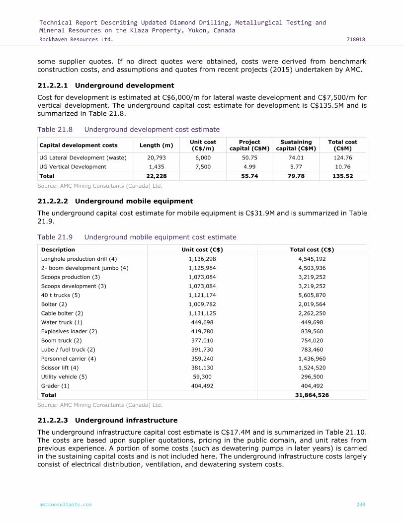
Technical Report Describing Updated Diamond Drilling, Metallurgical Testing and Mineral Resources on the Klaza Property, Yukon, Canada
Rockhaven Resources Ltd. 718018
amcconsultants.com 230
some supplier quotes. If no direct quotes were obtained, costs were derived from benchmark
construction costs, and assumptions and quotes from recent projects (2015) undertaken by AMC.
21.2.2.1 Underground development
Cost for development is estimated at C$6,000/m for lateral waste development and C$7,500/m for
vertical development. The underground capital cost estimate for development is C$135.5M and is
summarized in Table 21.8.
Table 21.8 Underground development cost estimate
Capital development costs Length (m) Unit cost (C$/m)
Project capital (C$M)
Sustaining capital (C$M)
Total cost (C$M)
UG Lateral Development (waste) 20,793 6,000 50.75 74.01 124.76
UG Vertical Development 1,435 7,500 4.99 5.77 10.76
Total 22,228 55.74 79.78 135.52
Source: AMC Mining Consultants (Canada) Ltd.
21.2.2.2 Underground mobile equipment
The underground capital cost estimate for mobile equipment is C$31.9M and is summarized in Table
21.9.
Table 21.9 Underground mobile equipment cost estimate
Description Unit cost (C$) Total cost (C$)
Longhole production drill (4) 1,136,298 4,545,192
2- boom development jumbo (4) 1,125,984 4,503,936
Scoops production (3) 1,073,084 3,219,252
Scoops development (3) 1,073,084 3,219,252
40 t trucks (5) 1,121,174 5,605,870
Bolter (2) 1,009,782 2,019,564
Cable bolter (2) 1,131,125 2,262,250
Water truck (1) 449,698 449,698
Explosives loader (2) 419,780 839,560
Boom truck (2) 377,010 754,020
Lube / fuel truck (2) 391,730 783,460
Personnel carrier (4) 359,240 1,436,960
Scissor lift (4) 381,130 1,524,520
Utility vehicle (5) 59,300 296,500
Grader (1) 404,492 404,492
Total 31,864,526
Source: AMC Mining Consultants (Canada) Ltd.
21.2.2.3 Underground infrastructure
The underground infrastructure capital cost estimate is C$17.4M and is summarized in Table 21.10.
The costs are based upon supplier quotations, pricing in the public domain, and unit rates from
previous experience. A portion of some costs (such as dewatering pumps in later years) is carried
in the sustaining capital costs and is not included here. The underground infrastructure costs largely
consist of electrical distribution, ventilation, and dewatering system costs.

Technical Report Describing Updated Diamond Drilling, Metallurgical Testing and Mineral Resources on the Klaza Property, Yukon, Canada
Rockhaven Resources Ltd. 718018
amcconsultants.com 231
Table 21.10 Underground infrastructure cost estimate
Description Total cost (C$)
Electrical
Underground electrical distribution and equipment 5,100,000
Communications system and hardware 1,000,000
Ventilation
Klaza West exhaust set-up: 150 HP 300,000
BRX West exhaust set-up: 250 HP 500,000
BRX Central exhaust set-up: 100 HP 200,000
Klaza Central exhaust set-up: 200 HP 400,000
Klaza East exhaust set-up: 50 HP 100,000
Distribution fans on six operating levels 1,500,000
Mine air heaters including enclosure (propane) 1,000,000
Dewatering
Western BRX pumps, sumps, switchgear, piping 1,400,000
Central BRX pumps, sumps, switchgear, piping 500,000
Western Klaza pumps, sumps, switchgear, piping 400,000
Central Klaza pumps, sumps, switchgear, piping 900,000
Supply system 300,000
Other underground infrastructure
Workshops 800,000
Magazines 100,000
Fuel / lube storage 400,000
Refuge stations 700,000
Lunch rooms 200,000
Escape way ladders 200,000
Mine rescue equipment 100,000
Lamp / battery rooms 100,000
Underground air compressors 200,000
Portal infrastructure 1,000,000
Total 17,400,000
Source: AMC Mining Consultants (Canada) Ltd.
21.2.3 Process plant
The process plant capital cost estimate is C$91.1M and is summarized in Table 21.11. This cost
estimate was provided by BCM.
The capital costs were developed using vendor quotes, BCM internal files, other project benchmarks,
industry factors, and literature.
These costs represent the direct capital costs, with delivery, construction and installation. Included
are construction labour, civils, electrical, instrumentation, piping, pumps, and control systems. No
EPCM, contingency, and other indirect costs are included.
Package quotes were received for the major equipment suppliers in crushing and grinding, flotation,
autoclave, acacia leach, CIP and carbon handling and refinery. Approximately 69% of the total
equipment costs are based on external quotes and this provides a reasonable level of accuracy for

Technical Report Describing Updated Diamond Drilling, Metallurgical Testing and Mineral Resources on the Klaza Property, Yukon, Canada
Rockhaven Resources Ltd. 718018
amcconsultants.com 232
the estimate. The balance of costs was taken from industry standards, and typical capital cost
estimation factors.
The process plant building cost was estimated by AMC (C$17M). This included the building shell,
HVAC, electrical, and plumbing for the envelope only. The raw mineralized rock bin (structural steel
and plate fabrication) was estimated as part of the process building cost.
Table 21.11 Mill area capital estimate
Description Total cost (C$)
Crushing 3,300,000
Grinding 13,500,000
Flotation 10,400,000
Dewatering 3,200,000
Autoclave, CCD Neutralization 22,700,000
Acacia Leach 2,100,000
Leach and CIP 4,500,000
Carbon handling and refinery 2,400,000
Reagents 4,800,000
Ancillaries 7,200,000
Building 17,000,000
Total 91,100,000
Source: Blue Coast Metallurgy Ltd.
21.2.4 Surface infrastructure
The capital cost estimate for the surface infrastructure is based upon supplier quotations, factored
costs from previous projects, pricing in the public domain, factored published labour productivities,
and experience regarding unit rates.
The capital cost estimate for surface infrastructure is C$13.7M, and is summarized in Table 21.12.
The major component of this cost estimate is site roads and refurbishment of access roads, mine
office, mine dry, and maintenance workshop. Water for the mine site and processing plant will be
supplied from the Klaza river. The cost estimate allows for heated and insulated steel piping, pump
and housing, modular filtration unit, and modular potable water treatment.
As part of the PEA, AMC completed a trade-off study between the cost of diesel generated and grid
electrical power. Over the life of the mine the use of grid power was shown to be advantageous to
the value of the project. The capital cost of the power line (provided by the utility) is included as a
component of the operating costs for electrical power and is, therefore, not included here.

Technical Report Describing Updated Diamond Drilling, Metallurgical Testing and Mineral Resources on the Klaza Property, Yukon, Canada
Rockhaven Resources Ltd. 718018
amcconsultants.com 233
Table 21.12 Surface infrastructure cost estimate
Description Total cost (C$)
Surface ancillary equipment 940,175
Power and communications 1,700,000
Water 300,000
Roads 1,431,040
Buildings, fuel and gas storage 6,600,000
Water supply / treatment 250,000
Fuel and oil storage 500,000
Storage bins 2,000,000
Total 13,721,215
Source: AMC Mining Consultants (Canada) Ltd.
21.2.5 Closure costs
Closure costs are expected to be low and involve re-handle of top soil over waste dumps and
seeding, monitoring of the TSF, removal of buildings, clearing of storage and laydown areas,
plugging the portals and ventilation raises and reclamation costs. Closure of the Hydromet Residue
and Flotation Tailings facilities will involve a progressive capping of the facility with a waste rock
and overburden blanket. Closure of the pits involves capping the final tailings surface with a waste
rock and overburden blanket. These costs are assumed to be covered by the sale of mobile
equipment and processing and surface infrastructure at the end of the LOM.
21.2.6 Sustaining capital
Capital costs for ongoing underground development after the project period (first four years), are
considered to be sustaining costs. These costs have been summarized above in Table 21.8.
Additional sustaining capital is based on 5% of total project capital expenditure to cover equipment
rebuilds / replacement, and repairs to fixed equipment and infrastructure. The sustaining capital
over the LOM is estimated to be C$96M.
21.2.7 Indirect capital
Indirect capital (owners cost and EPCM) is assumed to be 5% of the project capital cost estimate.
Indirect capital costs are estimated to be C$11M.
21.2.8 Contingency
Contingency is applied to the project capital only (not sustaining capital) at 15% of the capital
expenditure. The estimated contingency for the project is C$34M.
21.2.9 Total capital cost estimate
The total capital cost is estimated to be C$358M and is summarized in Table 21.13. The capital cost
estimate is split into project and sustaining capital and detailed by year in Table 21.14.

Technical Report Describing Updated Diamond Drilling, Metallurgical Testing and Mineral Resources on the Klaza Property, Yukon, Canada
Rockhaven Resources Ltd. 718018
amcconsultants.com 234
Table 21.13 Total capital cost estimate
Description Total cost (C$M)
Underground lateral development 125
Underground vertical development 11
Floatation tailings storage & residue tailings storage 10
Underground mine infrastructure 17
Mobile equipment 32
Processing plant 91
Surface infrastructure 14
Capital indirects 11
Contingency 34
Additional 5% sustaining for equipment rebuilds 13
Total capital cost 358
Project capital 262
Sustaining capital 96
Source: AMC Mining Consultants (Canada) Ltd.
Table 21.14 Project and sustaining capital cost estimate
Capital cost estimate Yr0 Yr1 Yr2 Yr3 Yr4 Yr5 Yr6 Yr7 Yr8 Yr9 Yr10 Yr11 Yr12 Yr13 Yr14 Total
Project capital (C$M) 85 102 32 42 - - - - - - - - - - - 262
Sustaining capital (C$M) - - - - 24 21 20 7 2 13 5 1 1 1 1 96
Total (C$M) 85 102 32 42 24 21 20 7 2 13 5 1 1 1 1 358
Source: AMC Mining Consultants (Canada) Ltd.

Technical Report Describing Updated Diamond Drilling, Metallurgical Testing and Mineral Resources on the Klaza Property, Yukon, Canada
Rockhaven Resources Ltd. 718018
amcconsultants.com 235
22 Economic analysis
This report discloses the results of an updated Mineral Resource estimate incorporating 2016 and
2017 drilling results, and additional metallurgical studies. It is an update to those Mineral Resources
and metallurgical results reported in a PEA Technical Report prepared by AMC for Rockhaven in
February 2016. The results of the 2016 PEA Technical Report described herein are based on the
earlier Mineral Resource model, and the studies related to the PEA have not yet been updated to
consider the new Mineral Resource model and the modified metallurgical treatment scheme.
This section was taken from the NI 43-101 technical report titled “Technical Report and PEA for the
Klaza Au-Ag Deposit, Yukon Canada for Rockhaven Resources Ltd.” dated 26 February 2016. This
section remains unchanged and is included for completeness and continuity.
22.1 Assumptions
All currency is in Canadian dollars (C$) unless otherwise stated. Pricing in US dollars (US$) was
converted to C$ using the exchange rate C$1:US$0.75. The cost estimate was prepared with a base
date of Year 0 and does not include any escalation beyond this date. For net present value (NPV)
estimation, all costs and revenues are discounted at 5% from the base date. Metal prices were
selected after discussion with Rockhaven and referencing current markets and forecasts in the public
domain. A corporate tax rate of 30% is applied as the mining income will be earned in the Yukon.
It is assumed that there are no royalties to be paid.
22.2 Economic analysis
AMC conducted a high level economic assessment of the conceptual operation of a combined Klaza
open pit and underground mine. The combined open pit and underground mine is projected to
generate approximately C$150M pre-tax NPV and C$86M post-tax NPV at 5% discount rate, pre-tax
IRR of 20% and post-tax IRR of 14%. Project capital is estimated at C$262M with a payback period
of 7 years (discounted pre-tax cash flow from base date of Year 0). Key assumptions and results of
the Klaza combined open pit and underground mine economics are provided in the Table 22.1 below.
The LOM production schedule, average metal grades, recovered metal, and cash flow forecast is
shown in Table 22.2.
The PEA is preliminary in nature. It includes Inferred Mineral Resources that are considered too
speculative geologically to have the economic considerations applied to them that would enable
them to be categorized as Mineral Reserves. There is no certainty that the PEA will be realized.

Technical Report Describing Updated Diamond Drilling, Metallurgical Testing and Mineral Resources on the Klaza Property, Yukon, Canada
Rockhaven Resources Ltd. 718018
amcconsultants.com 236
Table 22.1 Klaza combined open pit and underground mine – key economic assumptions and
results
Klaza Unit Value
Total mineralized rock kt 6,444
Total waste production kt 18,686
Gold grade 1 g/t 3.3
Silver grade 1 g/t 77
Lead grade 1 % 0.7
Zinc grade 1 % 0.8
Gold recovery 1 % 94
Silver recovery 1 % 88
Lead recovery 1 % 83
Zinc recovery 1 % 84
Gold price US$/oz 1,200
Silver price US$/oz 16.00
Lead price US$/lb 0.80
Zinc price US$/lb 0.85
Gold payable 2 % 97
Silver payable 2 % 81
Lead payable 2 % 62
Zinc payable 2 % 52
Payable gold metal kg 19,606
Payable silver metal kg 353,457
Payable lead metal Tonnes 23,233
Payable zinc metal Tonnes 23,792
Revenue split by commodity (gold) % 74
Revenue split by commodity (silver) % 18
Revenue split by commodity (lead) % 4
Revenue split by commodity (zinc) % 4
Total net revenue C$M 1,365
Capital costs C$M 358
Operating costs (total) 3 C$M 741
Mine operating costs 4 C$/t 59.7
Process and tails storage operating costs C$/t 43.4
Operating costs (total) 3 C$/t 115.0
Operating cash cost (AuEq) US$/oz AuEQ 651.5
Total all in sustaining cost (AuEq) US$/oz AuEQ 965.9
Payback period 5 Yrs 7
Cumulative net cash flow 6 C$M 266
Pre-tax NPV 7 C$M 150
Pre-tax IRR % 20
Post-tax NPV 7 C$M 86
Post-tax IRR % 14
Notes: 1 LOM average. 2 Overall payable % includes treatment, transport, refining costs and selling costs. 3 Includes mine operating costs, milling, and mine G&A. 4 Includes open pit and underground operating costs. 5 Values are pre-tax and discounted at 5%, from base date of Year 0. 6 Pre-tax and undiscounted. 7 At 5% discount rate. Source: AMC Mining Consultants (Canada) Ltd.

Technical Report Describing Updated Diamond Drilling, Metallurgical Testing and Mineral Resources on the Klaza Property, Yukon, Canada
Rockhaven Resources Ltd. 718018
amcconsultants.com 237
Table 22.2 Klaza production and cash flow forecast
Unit/yr 0 1 2 3 4 5 6 7 8 9 10 11 12 13 14 Total
Mine production
Open pit - (Klaza, BRX Central, West) kt - 380 373 245 144 163 - - - - - - - - - 1,305
Underground - (Klaza, BRX Central, West) kt 10 90 177 305 406 391 551 550 549 509 524 470 310 203 93 5,139
Total mined – Mineralized rock kt 10 470 550 550 550 554 551 550 549 509 524 470 310 203 93 6,444
Open pit - waste (Klaza, BRX Central, West) kt 4,306 4,253 4,044 3,892 973 - - - - - - - - - - 17,467
Underground - waste (Klaza, BRX Central, West) kt 127 144 85 157 203 166 155 46 8 104 23 0 - - - 1,219
Total mined - waste kt 4,433 4,398 4,128 4,048 1,176 166 155 46 8 104 23 0 - - - 18,686
Total development - lateral m 2,254 3,690 2,782 4,527 5,467 5,420 6,586 3,558 2,059 3,320 1,601 236 145 34 - 41,680
Total development - vertical m 115 199 33 318 251 341 98 - - 10 69 - - - - 1,435
Stockpile (Klaza, BRX Central, West) kt 10 10 10 10 10 14 15 15 14 - - - - - - 108
Total mill feed kt - 470 550 550 550 550 550 550 550 523 524 470 310 203 93 6,444
Gold g/t - 3.7 3.7 4.3 4.8 2.9 4.0 3.7 3.4 2.5 2.2 2.3 2.6 2.2 2.5 3.3
Silver g/t - 49 49 72 1100 57 98 102 95 95 82 86 44 50 24 77
Lead % 0.6% 0.8% 0.7% 1.0% 0.6% 0.6% 0.7% 0.6% 0.8% 0.8% 0.9% 0.6% 0.3% 0.2% 0.7%
Zinc % 1.1% 1.0% 1.0% 1.0% 0.7% 0.7% 0.8% 0.8% 0.8% 0.9% 0.8% 0.5% 0.6% 0.7% 0.8%
Recoveries
Overall gold recovery % - 94% 94% 94% 94% 94% 94% 94% 94% 94% 94% 94% 94% 94% 94% 94%
Overall silver recovery % - 88% 88% 88% 88% 88% 88% 88% 88% 88% 88% 88% 88% 88% 88% 88%
Overall lead recovery % - 83% 83% 83% 83% 83% 83% 83% 83% 83% 83% 83% 83% 83% 83% 83%
Overall zinc recovery % - 84% 84% 84% 84% 84% 84% 84% 84% 84% 84% 84% 84% 84% 84% 84%
Total payable metal
Gold kg - 1,570 1,834 2,167 2,419 1,450 1,993 1,867 1,724 1,187 1,042 993 742 407 211 19,606
Silver kg - 16,316 19,180 28,033 39,309 22,366 37,261 40,168 37,210 35,559 30,624 28,728 9,822 7,296 1,584 353,457
Lead t - 1,554 2,166 1,955 2,764 1,813 1,736 2,030 1,688 2,020 2,066 2,122 900 308 110 23,233
Zinc t - 2,228 2,423 2,391 2,413 1,663 1,702 2,018 1,815 1,836 2,162 1,677 648 511 304 23,792
Overall gold payable % - 97% 97% 97% 97% 97% 97% 97% 97% 97% 97% 97% 97% 97% 97% 97%
Overall silver payable % - 81% 81% 81% 81% 81% 81% 81% 81% 81% 81% 81% 81% 81% 81% 81%
Overall lead payable % - 62% 62% 62% 62% 62% 62% 62% 62% 62% 62% 62% 62% 62% 62% 62%
Overall zinc payable % - 52% 52% 52% 52% 52% 52% 52% 52% 52% 52% 52% 52% 52% 52% 52%
Total net revenue C$M - 101 118 141 164 98 136 133 123 95 85 80 49 28 13 1,365

Technical Report Describing Updated Diamond Drilling, Metallurgical Testing and Mineral Resources on the Klaza Property, Yukon, Canada
Rockhaven Resources Ltd. 718018
amcconsultants.com 238
Unit/yr 0 1 2 3 4 5 6 7 8 9 10 11 12 13 14 Total
Operating costs
Mining C$M 15 26 32 37 30 25 32 32 32 30 31 27 18 12 5 384
Processing and tailings storage C$M - 22 24 24 25 23 23 23 24 22 22 21 12 9 4 279
General and administration C$M - 6 7 7 7 7 7 7 7 6 6 6 4 2 1 77
Total operating cost C$M 15 53 63 68 62 54 62 62 63 58 59 54 34 24 11 741
Capital costs
Project capital C$M 85 102 32 42 - - - - - - - - - - - 262
Sustaining capital C$M - - - - 24 21 20 7 2 13 5 1 1 1 1 96
Total capital cost C$M 85 102 32 42 24 21 20 7 3 13 5 1 1 1 1 358
Undiscounted cash flows (pre-tax) C$M (100) (54) 23 32 78 23 55 64 57 24 22 25 13 3 1 266
Undiscounted cash flows (post tax) C$M (100) (54) 20 22 59 20 41 50 45 18 18 20 12 3 1 176
Discounted cash flows (pre-tax) C$M (95) (49) 20 26 61 18 39 44 37 15 13 14 7 2 1 150
Discounted cash flows (post-tax) C$M (95) (49) 17 18 46 15 29 34 29 11 11 11 6 2 1 86
Note: Totals may not add up exactly due to rounding. Source: AMC Mining Consultants (Canada) Ltd.

Technical Report Describing Updated Diamond Drilling, Metallurgical Testing and Mineral Resources on the Klaza Property, Yukon, Canada
Rockhaven Resources Ltd. 718018
amcconsultants.com 239
22.3 Sensitivity analysis
AMC has carried out a sensitivity analysis of the projection for combined open pit and underground
mine economics. The sensitivity analysis examined the impact on pre-tax and post-tax NPV (at 5%
discount rate) of a 15% positive or negative change in metal prices, operating costs, capital costs
and corporate tax rate. The results of the pre-tax sensitivity analysis are summarized in Table 22.3
and Figure 22.1. The results of the post-tax sensitivity analysis are summarized in Table 22.4. and
Figure 22.2.
The results show that the pre-tax NPV is robust and remains positive for the range of sensitivities
evaluated. The post-tax NPV is more marginal, but also remains positive for the range of sensitivities
evaluated.
Pre-tax and post-tax NPV is most sensitive to changes in the gold price (as well as grade or
recovery). It is also significantly sensitive to changes in mining operating costs and total capital
costs. The NPV is moderately sensitive to changes in processing operating costs and changes in the
silver price. Sensitivity to changes in the lead price, zinc price and corporate tax rate is minimal.
Note in Figure 22.1 and Figure 22.2, lead price and zinc price follow the same line, and so do mining
operating costs and total capital costs.
Table 22.3 Klaza economic sensitivity analysis (pre-tax)
Item Value Unit Pre-tax NPV (C$M) Pre-tax IRR %
Base case (NPV @ 5%) 150 20
Gold price - fall 15% 1,020 US$/oz 41 9
Gold price - increase 15% 1,380 US$/oz 259 30
Silver price - fall 15% 13.60 US$/oz 125 18
Silver price - increase 15% 18.40 US$/oz 175 22
Lead price - fall 15% 0.68 US$/lb 144 19
Lead price - increase 15% 0.92 US$/lb 156 20
Zinc price - fall 15% 0.72 US$/lb 144 19
Zinc price - increase 15% 0.98 US$/lb 156 20
Mining operating cost - decrease 15% 50.7 C$/t 191 24
Mining operating cost - increase 15% 68.6 C$/t 109 16
Processing operating cost - decrease 15% 36.6 C$/t 179 22
Processing operating cost - increase 15% 49.5 C$/t 121 17
Total Capex - decrease 15% 304 C$M 188 26
Total Capex - increase 15% 411 C$M 111 15
Source: AMC Mining Consultants (Canada) Ltd.

Technical Report Describing Updated Diamond Drilling, Metallurgical Testing and Mineral Resources on the Klaza Property, Yukon, Canada
Rockhaven Resources Ltd. 718018
amcconsultants.com 240
Table 22.4 Klaza economic sensitivity analysis (post-tax)
Item Value Unit Post-tax NPV (C$M) Post-tax IRR %
Base case (NPV @ 5%) 86 14
Gold price - fall 15% 1,020 US$/oz 9 6
Gold price - increase 15% 1,380 US$/oz 163 22
Silver price - fall 15% 13.60 US$/oz 68 12
Silver price - increase 15% 18.40 US$/oz 104 16
Lead price - fall 15% 0.68 US$/lb 82 14
Lead price - increase 15% 0.92 US$/lb 90 15
Zinc price - fall 15% 0.72 US$/lb 81 14
Zinc price - increase 15% 0.98 US$/lb 90 15
Mining operating cost - decrease 15% 50.7 C$/t 116 17
Mining operating cost - increase 15% 68.6 C$/t 55 11
Processing operating cost - decrease 15% 36.6 C$/t 107 16
Processing operating cost - increase 15% 49.5 C$/t 64 12
Total Capex - decrease 15% 304 C$M 116 19
Total Capex - increase 15% 411 C$M 55 10
Corporate tax rate - decrease 15% 25% % 95 15
Corporate tax rate - increase 15% 35% % 76 13
Source: AMC Mining Consultants (Canada) Ltd.
Figure 22.1 Sensitivity analysis – pre-tax NPV at 5% discount rate
Source: AMC Mining Consultants (Canada) Ltd.

Technical Report Describing Updated Diamond Drilling, Metallurgical Testing and Mineral Resources on the Klaza Property, Yukon, Canada
Rockhaven Resources Ltd. 718018
amcconsultants.com 241
Figure 22.2 Sensitivity analysis – post-tax NPV at 5% discount rate
Source: AMC Mining Consultants (Canada) Ltd.

Technical Report Describing Updated Diamond Drilling, Metallurgical Testing and Mineral Resources on the Klaza Property, Yukon, Canada
Rockhaven Resources Ltd. 718018
amcconsultants.com 242
23 Adjacent properties
There are two main types of adjacent properties near the Property – active placer gold operations
and the Mount Nansen lode gold-silver deposit. The qualified person has not verified the information
provide regarding adjacent properties. Mineralization on the adjacent properties is not considered
indicative of the mineralization on the Property.
The most proximal property is an active placer gold operation located about 300 m along strike to
the northwest of the BRX and Klaza zones and another operation lies immediately southeast of the
Property (Van Loon and Bond, 2014). Placer claims have been staked by other parties along all of
the creeks draining and surrounding the known mineralized zones. None of the placer claims
significantly overlap any of the Mineral Resources on the Property.
Production figures for placer gold operations based on royalty reporting are considered a minimum.
Placer gold was discovered in 1899, but early production figures are not available. Total cumulative
gold production from the Mount Nansen area, between 1980 to 2017, is reported to be 41,167 crude
ounces (Bond, pers. comm., 2017). The available figures do not attribute ounces to specific
operations, but rather state production by drainage.
Creeks and tributaries draining the northwest and northern portion of the ridge hosting the
mineralized structural zones on the property, including the Western BRX, have reported a total
cumulative gold production of 3,022 crude ounces. To the southeast, the eastern zones drain into
Summit creek, and portions of Nansen creek. These reported a total cumulative gold production of
1,362 crude ounces and 27,097 crude ounces respectively.
The Mount Nansen lode gold-silver property is located approximately nine kilometres southeast of
the deposit area. The Mount Nansen property covers the former Mount Nansen mine site, including
disused buildings, a tailings facility, and an open pit at the Brown-McDade Deposit and underground
workings at the Huestis Deposit. The Mount Nansen property is under care and maintenance.
The Mount Nansen Property hosts two gold-silver deposits and part of a third deposit (Deklerk and
Burke, 2008). Although mineralization found at the Mount Nansen Property and the adjoining
property owned by 1011308 B.C. Ltd. is similar in tenor to mineralization found at the Property, the
mineralogy and resources at those properties are not considered to be representative of mineralogy
and resources on the Property.
Gold and silver mineralization occurs on the Mount Nansen property in a series of anastomosing
veins within northwesterly trending fault or shear zones. Mineralized structures consist of
quartz-sulphide veins and associated clay-rich alteration zones.
Production from the Mount Nansen property occurred over three periods: the first in 1967 and 1968;
the second in 1975 and 1976; and, the last from 1996 to 1999. The latest operation continued
intermittently until BYG Natural Resources Inc., the owner at the time, was placed into receivership.
Published statistics state total production of 26,685 oz of gold and 214,897 oz of silver between
1967 and 1999. This total does not account for missing data from 1976.
There are a number of other gold-silver showings on properties owned by other parties within five
kilometres of the Property. Although encouraging drill and trench results have been returned from
some of these showings, none of them has a Mineral Resource estimate.

Technical Report Describing Updated Diamond Drilling, Metallurgical Testing and Mineral Resources on the Klaza Property, Yukon, Canada
Rockhaven Resources Ltd. 718018
amcconsultants.com 243
24 Other relevant data and information
There is no other relevant data and information.
Technical Report Describing Updated Diamond Drilling, Metallurgical Testing and Mineral Resources on the Klaza Property, Yukon, Canada
Rockhaven Resources Ltd. 718018
amcconsultants.com 244
25 Interpretation and conclusions
This report discloses the results of an updated Mineral Resource estimate incorporating 2016 and
2017 drilling results, and additional metallurgical studies. It is an update to those Mineral Resources
and metallurgical results reported in a PEA Technical Report prepared by AMC for Rockhaven in
February 2016. The results of the 2016 PEA Technical Report described herein are based on the
earlier Mineral Resource model, and the studies related to the PEA have not yet been updated to
consider the new Mineral Resource model and the modified metallurgical treatment scheme.
This section was taken from the NI 43-101 technical report titled “Technical Report and PEA for the
Klaza Au-Ag Deposit, Yukon Canada for Rockhaven Resources Ltd.” dated 26 February 2016. This
section remains unchanged and is included for completeness and continuity.
25.1 Summary
The results of this PEA suggest that the Project has good economic potential and warrants further
study.
The PEA is preliminary in nature. It includes Inferred Mineral Resources that are considered too
speculative geologically to have the economic considerations applied to them that would enable
them to be categorized as Mineral Reserves. There is no certainty that the PEA will be realized.
25.2 Risk and opportunity management
Standard industry practices, equipment and processes were assumed for the PEA. The authors of
the report are not aware of any unusual risks or uncertainties that could affect the reliability
or confidence in the PEA results relative to the data and information available and the level of study.
Most mining projects are exposed to risks that may impact the economic outlook to varying
degrees. External factors that are largely beyond the control of the project proponents can be
difficult to anticipate and mitigate; although, in many instances, some reduction in risk may be
achieved by regular reviews and interventions over the life of the project. Certain opportunities
that can enhance project economics may also be identified during subsequent studies.
Table 25.1 and Table 25.2 summarize currently perceived project risks and opportunities for the
Klaza Property, including potential impacts, and possible mitigations. A formal review of the
likelihood and consequence ratings and pre- and post-mitigation rankings was not conducted but is
recommended for the next stage of project development.
The Mineral Resource for the Klaza Property used in the economic analysis comprised entirely
Inferred Mineral Resources. An Inferred Mineral Resource is that part of a Mineral Resource for
which tonnage, grade and mineral content can be estimated and reasonably assumed, but not
verified. Conceptual economic projections based on an Inferred Mineral Resource must, therefore,
be regarded with an appropriate degree of uncertainty, recognizing that it cannot be assumed that
all or any part of an Inferred Mineral Resource will be upgraded to an Indicated or Measured Mineral
Resource as a result of continued exploration.
Although the Property is remotely located in the Yukon, this does not pose significant logistical
challenges that may affect the movement of people to and from the site, supplies inbound, and
concentrates outbound. There is an existing road to the site which, except for the final 13 km, is
maintained year-round by the Yukon Department of Highways and Public Works. Necessary
materials and supplies can be brought to site as required throughout the year.

Technical Report Describing Updated Diamond Drilling, Metallurgical Testing and Mineral Resources on the Klaza Property, Yukon, Canada
Rockhaven Resources Ltd. 718018
amcconsultants.com 245
Extreme winter temperatures, possibly between -20° to -30°C, may impact personnel and
equipment productivities during construction and operations.
General risks associated with open pit and underground mining related to aspects such as
geotechnical conditions, equipment availability and productivity, and personnel productivity are
anticipated to be similar to those experienced at other northern operations.

Technical Report Describing Updated Diamond Drilling, Metallurgical Testing and Mineral Resources on the Klaza Property, Yukon, Canada
Rockhaven Resources Ltd. 718018
amcconsultants.com 246
Table 25.1 Significant project risks
Area Description Aspect Impact
Risk mitigation Description Risk
Geology and exploration
Geological model
Accuracy of geological model
Model does not represent the deposit location and grade distribution accurately.
Faults and mineralized zones might not be accurately identified; significant change in mine design required. Mineral Resources are overstated. Project economics reduced.
Infill drilling
Mineral processing and metallurgical test work
Metallurgy Gold recovery
Gold recovery process is not optimized for the mineralogy and variations within it.
Reduced recoveries reduce Project economics. Redesign of the gold recovery process plant might lead to additional capital expenditure.
Additional sampling and metallurgical test work; further review of test work done to date.
Open pit mine
Geotechnical considerations
Pit design and stability
Under estimation of waste in the mine design.
Under estimation of operating costs.
Ongoing geotechnical testwork and mapping to optimize pit wall design.
Geotechnical considerations
Ground conditions
Under-estimation of the zone of weathering and geological structures.
Structure may impact on the pit design, mining assumptions, and economics of the pit.
Ongoing geotechnical testwork and drilling to better define zone of weathering.
Underground mine
Geotechnical considerations
Ground conditions
Under estimation of dilution and mining factors and inadequate crown pillar design.
Under-estimation of operating costs, over estimation of metal grades impact on economics.
Ongoing geotechnical monitoring and mapping; ongoing stope design and rock support review.
Hydrology
Inadequate hydrological modelling of ground water inflow.
Under design of dewatering infrastructure and pit slopes.
Modelling of ground water inflow in the mineralized zones.
Ground conditions
Reduced inter-level spacing.
Under estimation of ground conditions leading to reduced inter-level spacing, increased costs
and lower project economics.
Ongoing geotechnical monitoring and mapping; ongoing review of open pit and
underground scheduling.
Cost estimation
Project economics
Over estimation of project economics.
Benchmark costs used may be too low for remote site, significant changes to mine design and economics.
Advance level of detail for cost estimation,
first principles estimation.
Recovery methods
Crushing Crushing throughput
Two-stage crushing inadequate.
Reduce throughput. Installation of third crusher and resulting increase in capital and operating costs.
Ongoing sampling and metallurgical test work; further review of test work done to date.
Grinding Mill throughput
Final mineralized rock size of 70 microns P80 not achieved or coarser grind size adequate.
Reduction in gold recovery.
Ongoing sampling and metallurgical test work; further review of test work done to date.

Technical Report Describing Updated Diamond Drilling, Metallurgical Testing and Mineral Resources on the Klaza Property, Yukon, Canada
Rockhaven Resources Ltd. 718018
amcconsultants.com 247
Area Description Aspect Impact
Risk mitigation Description Risk
Gold recovery Gold recovery Gold recovery lower than test work indicates.
Reduced revenue and negative impact on Project economics.
Ongoing sampling and metallurgical test work; further review of test work done to date. Mineralized rock batching from specific deposits.
Gold recovery Hot cure Validation of hot cure process stage.
Higher operating costs due to incorrect assumptions on hot cure process.
Additional batch and semi-continuous
metallurgical test work.
On-site infrastructure
Power supply Inadequate supply locally available
Require alternate source of power.
Increased capital and operating cost.
Early engagement with local utility to determine future power expansion capacity.
Human resources
Mine camp Assume travel to and from Carmacks daily.
Unable to establish sufficient housing for mine workforce in Carmacks; inefficient costly operation.
Camp site is a potential alternative, explore availability of resources locally.
Off-site infrastructure
Access road Failure to maintain
Poor road access due to improper maintenance.
Materials and equipment cannot be transported to site as planned or required. Results in loss of production and / or increase in cost of air freighting.
Confirmation of future intent from local rural municipality or territory.
Environmental studies, permitting, and social or community impact
Permitting Regulatory process
Delay or failure to obtain necessary permits.
Delay in commencement of mining operations reduces Project economics and might impact Project financing.
Robust permitting process that addresses all Project requirements within the regulatory timelines.
Manpower Manpower Workforce complement and skills
Inability to attract or retain personnel with appropriate skills.
Increase in operating cost. Explore the availability of workforce locally.
Financial Financing
Securing reasonable capital
Failure to secure funding could slow or stop Project development.
Lower NPV. Explore means to reduce capital.
Source: AMC Mining Consultants (Canada) Ltd.

Technical Report Describing Updated Diamond Drilling, Metallurgical Testing and Mineral Resources on the Klaza Property, Yukon, Canada
Rockhaven Resources Ltd. 718018
amcconsultants.com 248
Table 25.2 Significant project opportunities
Area Description Aspect Impact
Opportunity steps Description Opportunity
Geology and exploration
Geological model
Accuracy of geological model
Model does not represent the deposit location and grade distribution accurately.
Mineral Resources are understated.
Infill drilling
Mineral processing and metallurgical test work
Metallurgy Gold recovery
Gold recovery process is not optimized for the mineralogy and variations within it.
Increased recoveries improve Project economics.
Additional sampling and metallurgical test work; further review of test work done to date.
Mineral Resource estimate
Mineral Resources
Resource expansion
Zones open at depth and laterally.
Inferred Mineral Resources may convert to Indicated Mineral Resources and improve confidence. Significant exploration potential within large land package with multiple greenfield targets.
Infill and exploration drilling.
Mining Production schedule
Optimization
Optimize the open pit to underground interface, sequence and timing of various zones.
Opportunity to explore increased production levels particularly in the early life of the mine, to make use of the full capacity of the mill.
Alternative production plans and assessment of project zones by value considering sequence and timing.
Recovery method
Preconcentration pressure oxidation versus bioleaching
Mill throughput, capital and operating cost
Potential to reduce mill throughput and increase crush size.
Visually, Klaza materials appear to be candidates for pre-concentration at a coarse crush size.
Pressure oxidation tends to be more power-intensive than bioleaching.
Ongoing sampling and metallurgical test work; further review of test work done to date.
Trade-off study
Financial
Capital Costs Cost reductions
Reduce capital requirements through alternate recovery methods.
Refer to recovery method
Refer to recovery method
Operating Costs
Cost reductions
Reduce operating costs through alternate recovery methods.
Refer to recovery method
Refer to recovery method
Source: AMC Mining Consultants (Canada) Ltd.

Technical Report Describing Updated Diamond Drilling, Metallurgical Testing and Mineral Resources on the Klaza Property, Yukon, Canada
Rockhaven Resources Ltd. 718018
amcconsultants.com 249
26 Recommendations
26.1 Geology and Mineral Resources
Work at the Klaza Property has defined significant, high-grade gold-silver-lead-zinc Mineral
Resources. AMC recommends the following:
• Conduct further drilling of the BRX East and other Eastern Zones in order to sufficiently
increase the drillhole density to enable completion of a Mineral Resource estimate.
• Collect samples from previously unsampled drill core intervals within the Eastern Zones in
order to complete the sample record.
• Conduct exploration diamond drilling beneath and along strike of prospective targets identified
by trenching and diamond drilling.
• Update the Mineral Resource estimate on completion of the drill program and additional
sampling within the Eastern Zones.
• Initiate an updated PEA utilizing the updated Mineral Resource and metallurgy.
• Going forward, take duplicate samples only from mineralized material.
26.2 Hydrology
The following Tetra Tech EBA recommendations are made for further hydrogeological assessment
at Klaza:
• Continue seasonal groundwater monitoring for the existing monitoring and observation wells.
• Survey all monitoring wells for their location and elevation of the top of the PVC casing with
an accuracy of about ±1 cm or better.
• Collect additional ground temperature and hydrogeological data from the existing observation
and monitoring wells, and drill additional wells as required. This data will allow updates to the
preliminary conceptual hydrogeological model with an emphasis on permafrost-groundwater
interaction.
• As mine planning progresses, install additional monitoring wells in the areas up and down
gradient of proposed mine infrastructure.
• Intergrate groundwater and surface water baseline data collection and interpret both datasets
to assess groundwater-surface water interaction.
26.3 Geotechnical
Obtain a better understanding of the factors affecting open pit and stope stability and the proposed
mining method from additional data collection, interpretation, and analysis, including the following:
• Developing a series of 3D models that includes lithology, alteration, and major structure.
• Using data from these models develop a 3D geotechnical model.
• Continue collecting geotechnical information during infill and exploration drilling. Preferably
orient core whenever possible to increase confidence and understanding of structures.
• Implement a laboratory testing program on the various lithologies to assist in understanding
rock properties. The following suite of rock property tests is recommended: Uniaxial
compressive strength (UCS) with Young’s modulus (E) and Poisson’s ratio (v), Confined
compressive strength (triaxial), Indirect tensile strength (Brazilian test).
• As the mine is likely to be developed to depth > 300 m below ground level, in-situ stress
testing will likely be needed. This could be carried out once mining has commenced.

Technical Report Describing Updated Diamond Drilling, Metallurgical Testing and Mineral Resources on the Klaza Property, Yukon, Canada
Rockhaven Resources Ltd. 718018
amcconsultants.com 250
26.4 Mining and infrastructure
AMC recommends the following work to be undertaken during the next phase of study:
• Re-evaluate open pit and underground mining opportunities for any updates to the Mineral
Resource estimate.
• Reassess open pit-underground interface and specifics of crown pillar requirements.
• Further investigate underground stope sizing and confirm mining method.
• Further investigate the open pit mining method and bench height to evaluate means of
reducing dilution.
• Develop development and production schedules.
• Project groundwater inflow to the proposed pits and underground mines from updated
hydrogeological modelling.
• Should the hydrogeological modelling and study of the ground water regime indicate potential
for large quantities of inflow into the mine, investigate a non-contact dewatering system.
Water captured prior to entering the mining floor can reduce the cost of water treatment later.
• Undertake cost estimation and obtain contractor quotes for operating costs.
• Increase the level of detail for infrastructure engineering to better define capital costs.
• Undertake further work to support the assumptions that:
⎯ Mine workforce would be based in Carmacks and bused to and from site on a daily basis.
⎯ Sufficient local grid power is available.
26.5 Processing and metallurgical testwork
BCM recommends the following for the Klaza project, ahead of preparation of a revised PEA study:
• Eastern BRX process development: For the flotation-leach process developed using whole ore
material, demonstrate its application to EBRX pre-concentrate together with a projection of
metallurgical recoveries.
• Pre-concentration: Conduct sufficient testing to establish PEA level metallurgical projections
and process design for the use of pre-concentration on all zones except Western Klaza.
• Refractory gold concentrate development: Continue testing aimed at maximizing the gold
grade / recovery relationship for arsenopyrite-hosted refractory gold.
• Conduct a marketing study on the refractory gold concentrate.
26.6 Tailings Storage Facility
• Evaluate additional tailings storage potential within the Klaza open pits KL1 and 2 by
constructing containment dams across the low point of the pit and increasing storage capacity.
• Complete rheology testing and geotechnical testing of the tailings streams.
• Complete geotechnical investigations to evaluate foundation conditions and construction
material sources.
• Complete geotechnical investigations at the Klaza KL1 and 2 open pits to determine suitability
for tailings storage.
26.7 Environmental
Continue ongoing collection and evaluation of baseline data.
26.8 Proposed budget for recommendations
An approximate budget for the recommended work described above is presented in Table 26.1.

Technical Report Describing Updated Diamond Drilling, Metallurgical Testing and Mineral Resources on the Klaza Property, Yukon, Canada
Rockhaven Resources Ltd. 718018
amcconsultants.com 251
Table 26.1 Proposed budget for recommendations
Parameter Cost (C$000’s)
Eastern Zone infill drilling (6,000 m @ $220/m) 1,320
Exploration drilling (6,000 m @ $220/m) 1,320
Hydrological monitoring 50
Geotechnical testwork, modelling, and interpretation 50
Metallurgical studies 60
Marketing study 20
Updated Resource and PEA 400
Environmental baseline studies to stage ready for EA 600
Contingency @ 15% 573
Total (excluding taxes) 4,393
Source: Archer, Cathro & Associates (1981) Limited.

Technical Report Describing Updated Diamond Drilling, Metallurgical Testing and Mineral Resources on the Klaza Property, Yukon, Canada
Rockhaven Resources Ltd. 718018
amcconsultants.com 252
27 References
Section 5
Environment Canada 2015, http://climate.weather.gc.ca/climate_normals/results_1961_1990_e.
html?stnID=1509&prov=YT&lang=e&province=YT&provBut=Go&month1=0&month2=12 76.
Section 6
Archer, A, R. and Onasick, E.P. 1980, NAT Joint Venture Final Report, Internal report prepared by
Archer, Cathro & Associates Limited. for Chevron Canada Limited and Armco Mineral Exploration
Ltd.
Brent, D. 1991, Assessment Report on Grizzly 1-24 claims, Whitehorse Mining Division, Prepared
for E. Curley, Assessment Report #092945.
Brownlee, D.J. 1981, Assessment report on a geophysical survey on the Tawa property, Whitehorse
Mining District, Yukon Territory, Prepared for BRX Mining and Petroleum Corp., Assessment Report
#090909.
Burrell, H. 2013a, Assessment report describing reverse circulation and diamond drilling at the Dade
Property, Prepared by Archer, Cathro & Associates (1981) Limited for Strategic Metals Ltd.,
Assessment Report #096434.
Burrell, H. 2013b, Assessment Report on the BBB property, Prepared for Strategic Metals Ltd. by
Archer, Cathro & Associates (1981) Limited.
Burrell, H. 2014, Assessment Report on the BBB property, Prepared for Strategic Metals Ltd. by
Archer, Cathro & Associates (1981) Limited.
Campbell, D.D. and Guardia, F. 1969, Summary report on the May group claims, Whitehorse Mining
District, Yukon Territory, Prepared for Esansee Explorations Limited, Assessment Report #060737.
Cathro, R.J. 1974, Regional Exploration in the Dawson Range District, Yukon for Klotassin Joint
Venture, Internal report prepared by Archer, Cathro & Associates Limited.
Cathro, R.J. and Culbert, R.E. 1969, Summary report on the 1969 field program, Dawson Range
Joint Venture Project, Yukon Territory.
Cathro, R.J. and Culbert, R.E. 1976 / 1975, Regional Exploration in the Dawson Range District,
Yukon for Klotassin Joint Venture, Internal report prepared by Archer, Cathro & Associates Limited.
Chung, C. 2011, Assessment Report prepared for Strategic Metals Ltd. by Archer, Cathro &
Associates (1981) Limited.
Curley, E. 1987, Prospecting and Exploration Report on the Jam Claims, Assessment Report
#092515.
Deklerk R. and Traynor S. 2005, Yukon MINFILE – A database of mineral occurrences, Yukon
Geological Survey, CD-ROM.
Dickinson, R.A. and Lewis, P.F. 1973, Drillhole logs filed for assessment work, Assessment report
by Area Exploration Company, Assessment Report #091327.

Technical Report Describing Updated Diamond Drilling, Metallurgical Testing and Mineral Resources on the Klaza Property, Yukon, Canada
Rockhaven Resources Ltd. 718018
amcconsultants.com 253
Dujakovic, Z., Visser, S. and Ewen, E. 1996, Assessment report describing Magnetometers, VLF-
EM, and Geochem Surveys on the KR 1-238 Claims, Prepared for BYG Natural Resources Inc. by
SJV Consultants Ltd., Assessment Report #093516.
Eaton, W.D. 1986, Assessment report on geology, geochemistry, geophysics and bulldozer
trenching on the Tawa property, Whitehorse Mining District, Yukon Territory, Report prepared for
Freegold Venture, Assessment Report #091889.
Eaton, W.D. 1989, Tawa Property – 1989 Final Report, Prepared for Chevron Minerals Ltd.
Eaton, W.D., and Walls, M.J. 1987, Assessment report on road construction and trenching on the
Tawa property, Whitehorse Mining District, Yukon Territory, Report prepared for Chevron Minerals
Ltd. and BYG Natural Resources Inc., Assessment Report #092083.
Eaton, W.D., and Walls, M.J. 1988, Assessment report on the Tawa property, Whitehorse Mining
District, Yukon Territory, Report prepared for Chevron Minerals Ltd. and BYG Natural Resources
Inc., Assessment Report #092585.
Ellemers, M. and Stroshein, R. 2005, Assessment report on diamond drilling on the Vic mineral
claims, Discovery Creek Project, Report prepared for Aurchem Exploration Ltd., Assessment Report
#095593.
Great Bear Resource Ltd. 2012a, 26 January 2012 News Release, Retrieved from
http://www.sedar.com.
Great Bear Resource Ltd. 2012b, 10 October 2012 News Release, Retrieved from
http://www.sedar.com.
Heberlein, K. and Lyons, L. 1986, Assessment report on geological, geophysical, geochemical, and
drilling on the Vic and VG claims, prepared for G. Dickson and Kerr Addison Mines Ltd., Assessment
Report #091907.
Hulstein, R. 2003, Assessment report on geological and geochemical work on the JRW 1-4 claims,
Whitehorse Mining District, Yukon Territory, Prepared for J. Dickson, Assessment Report #094425.
Langdon, M. 1992, Assessment report on reverse circulation drilling on Wedge 5-7, 10, Bull 6, Ras
1-2, Discovery Creek Project, Prepared for Aurchem Exploration Ltd., Assessment Report #093059.
Mac Gearailt, D. 2012, Report on the Klaza property: 2011 prospecting and sampling program.
Whitehorse Mining District, Yukon, Canada, Prepared on behalf of Goldstrike Resources Ltd,
Assessment Report #096082.
Main, C.A. 1987, Geological and Geochemical Program on the Toast Property, Assessment Report
#091973.
McClintock, J. 1986, Geological and Geochemical report on the Etzel and Wedge claims, Whitehorse
Mining District, Yukon Territory, Report prepared for Pearl Resources Ltd., Assessment Report
#091870.
Parker, A. 1968, Assessment report on the May claim group, Whitehorse Mining District, Yukon
Territory, Report prepared for Esansee Explorations Limited, Assessment Report #019090.

Technical Report Describing Updated Diamond Drilling, Metallurgical Testing and Mineral Resources on the Klaza Property, Yukon, Canada
Rockhaven Resources Ltd. 718018
amcconsultants.com 254
Pautler, J. 1994, Assessment Report on Grizzly property, Prepared for E. Curley, Assessment Report
#093229.
Robinson, 1959, Dickson Gold option, Carmacks, Yukon, Billy Claim group, Asbestos Corporation
(Exploration) Ltd., Assessment Report #092505.
Saunders, C.R. 1980, Assessment report on the Tawa Property, Whitehorse Mining District, Yukon
Territory, Report prepared for BRX Mining & Petroleum Corp., Assessment Report #090692.
Saunders, C.R. 1980b, Assessment report on the Tawa Property, Whitehorse Mining District, Yukon
Territory, Report prepared for BRX Mining & Petroleum Corp. Assessment Report #062050.
Smith, H. 2010, Assessment report on Dade Property prepared for Strategic Metals Ltd. by Archer,
Cathro & Associates (1981) Limited.
Smith, H. 2011, Assessment report on Dade Property prepared for Wolverine Minerals Corporation
by Archer, Cathro & Associates (1981) Limited.
Stroshein, R. 1999, Exploration report for the overburden stripping and diamond drilling program
on the Tawa-Klaza project, Whitehorse Mining District, Yukon Territory, Assessment Report #
093948.
Stroshein, R. 2001, Assessment report on geology, geochemistry, and trenching on the Vic, Wedge
12, and Bull 4 mineral claims, Discovery Creek Project, Prepared for Aurchem Exploration Ltd.,
Assessment Report #094238.
Stroshein, R. 2003, Assessment report on geology, geochemistry, and trenching on the Vic mineral
claims, Discovery Creek Project, Prepared for Aurchem Exploration Ltd., Assessment Report
#094400.
Stroshein, R. 2004, Exploration report for 2003 geological, geochemical and trenching on the
Discovery Creek Project in the Whitehorse Mining District, Yukon Territory, Assessment Report
#094450.
Stroshein, R. 2008, Assessment report on trenching and sampling on the Vic 30, Bull 4, and J. Bill
16 mineral claims, Discovery Creek Project, Prepared for Aurchem Exploration Ltd., Assessment
Report #094989.
Sutherland, K.S. 1988, Assessment report on stream sediment sample and prospecting on the Dic
property. Report prepared for Chesbar Resources Inc., Assessment Report #092533.
Tarswell, J. and Turner, M. 2012, Assessment report describing diamond and reverse circulation
percussion drilling, excavator trenching, soil sampling and geophysical and air photo surveys at the
Klaza property, Whitehorse Mining District, Yukon Territory, Report prepared for Rockhaven
Resources Ltd.
Tarswell, J. and Turner, M. 2013, Assessment report describing diamond drilling, excavator
trenching, soil sampling, mineralogical studies and metallurgical tests at the Klaza property,
Whitehorse Mining District, Yukon Territory, Report prepared for Rockhaven Resources Ltd.
Tarswell, J. and Turner, M. 2014, Assessment report describing Excavator trenching, geophysical
surveys, and metallurgical tests at the Klaza Property, Whitehorse Mining District, Yukon Territory,
Report prepared for Rockhaven Resources Ltd.

Technical Report Describing Updated Diamond Drilling, Metallurgical Testing and Mineral Resources on the Klaza Property, Yukon, Canada
Rockhaven Resources Ltd. 718018
amcconsultants.com 255
Turner, M. and Tarswell, J. 2011, Assessment report describing diamond drilling, excavator
trenching, soil sampling and geophysical surveys at the Klaza property, Whitehorse Mining District,
Yukon Territory, Prepared for Rockhaven Resources Ltd.
Wengzynowski, W.A. 2006, Assessment report describing line cutting and induced polarization
surveys at the Klaza Property, Whitehorse Mining District, Yukon Territory, Report prepared for
Bannockburn Resources Limited and ATAC Resources Ltd.
Wengzynowski, W.A., Giroux, G.H., Martin, C.J. 2015, NI 43-101 Technical Report describing
Geology, Mineralization, Geochemical Surveys, Geophysical Surveys, Diamond and Percussion
Drilling, Metallurgical Testing and Mineral Resources on the Klaza Property, Yukon, Report prepared
for Rockhaven Resources Ltd.
Yukon Geological Survey 2013, Yukon Geological Survey's Integrated Data System, Occurrence
Number 115I 096. Available at: http://data.geology.gov.yk.ca/Occurrence/14325.
Section 7
Aho, A.E., Mukans, V., and Reamsbottom, S.B. 1975, Geology of the Rico Claim Group, Assessment
Report by Kerr Addison Mines Limited, Assessment Report #091915.
Bostock, H.S. 1936, Carmacks district, Yukon, Geological Survey of Canada, Memoir 189.
Burrell, H. 2013, Assessment report describing reverse circulation and diamond drilling at the Dade
Property, Prepared by Archer, Cathro & Associates (1981) Limited for Strategic Metals Ltd.,
Assessment Report #096434.
Carlson, G.G. 1987, Geology of Mount Nansen (115I/3) and Stoddart Creek (115I/6) map areas,
Dawson Range, central Yukon, Exploration and Geological Services Division, Yukon, Indian and
Northern Affairs Canada, Open File 1987-2.
Colpron, M and Nelson, J.L. 2006, Paleozoic evolution and metallogeny of pericratonic terranes at
the ancient Pacific margin of North America, Canadian and Alaskan Cordillera, Special Paper:
Geological Association of Canada, 45, pp 523.
Ellemers, M. and Stroshein, R. 2005, Assessment Report on diamond drilling on the Vic mineral
claims, Discovery Creek Project, Report prepared for Aurchem Exploration Ltd., Assessment Report
#095593.
Gordey, S.P., and Makepeace, A.J. 2000, Yukon Digital Geology, 2 CD-ROM set, Geological Survey
of Canada, Open File D3826 for Exploration and Geological Services Division (EGSD), Yukon Region,
Indian and Northern Affairs Canada (DIAND) EGSD, Open File 1999-1(D).
Hart, C., and Langdon, M. 1997, Geology and Mineral Deposits of the Mount Nansen Camp, Yukon,
In: Yukon Exploration and Geology 1997, Exploration and Geological Services Division, Yukon,
Indian and Northern Affairs Canada, pp 129-138.
Mortensen, J.K., Appel, V.L. and Hart, C.J.R., 2003, Geological and U-Pb age constraints on base
and precious metal vein systems in the Mount Nansen area, eastern Dawson Range, Yukon, In:
Yukon Exploration and Geology 2002, D.S. Emond and L.L. Lewis (eds.), Exploration and Geological
Services Division, Yukon Region, Indian and Northern Affairs Canada, pp 165-174.

Technical Report Describing Updated Diamond Drilling, Metallurgical Testing and Mineral Resources on the Klaza Property, Yukon, Canada
Rockhaven Resources Ltd. 718018
amcconsultants.com 256
Mortensen, J.K., Hart, C.J.R., Tarswell, J. and Allan, M.M., 2016, U-Pb zircon age and Pb isotopic
constraints on the age and origin of porphyry vein mineralization in the eastern Dawson Range,
Yukon, In Yukon Exploration and Geology 2016. Yukon Geological Survey.
Payne, J. G. 2012, Petrographic Report, Report prepared for Rockhaven Resources Ltd., Assessment
Report #120320.
Piercey, S.J., Nelson, J.L., Colpron, M., Dusel-Bacon, C., Simard, R.-L., and Roots, C.F. 2006,
Paleozoic magmatism and crustal recycling along the ancient Pacific margin of North America,
northern Cordillera, in Colpron, M. and Nelson, J.L. Eds., Paleozoic Evolution and Metallogeny of
Pericratonic Terranes at the Ancient Pacific Margin of North America, Canadian and Alaskan
Cordillera, Geological Association of Canada Special Paper 45, pp 281-322.
Ross, A.A., Borntraeger, B., Martin, C.J., Methven, G., Lebleu, P., Hughes, W. 2016, Technical
Report and PEA for the Klaza Au-Ag Deposit, Yukon, Canada, Prepared for Rockhaven Resources
Ltd. by AMC Mining Consultants (Canada) Ltd.
Ryan, J.J., Westberg, E.E. Williams, S.P., and Chapman, J.B. 2016, Geology, Mount Nansen-Nisling
River area, Yukon; Geological Survey of Canada, Canadian Geoscience Map 292 (preliminary), scale
1:100 000. doi: 10.4095/298835
Sawyer, J.P.B., and Dickinson, R.A. 1976, Mount Nansen, Porphyry Copper and Copper-Molybdenum
Deposits of the Calc-Alkaline Suite, Paper 34, In Porphyry Deposits of the Canadian Cordillera, CIM
Special Volume 15, pp 336 - 343.
Tarswell, J. and Turner, M. 2012, Assessment report describing diamond and reverse circulation
percussion drilling, excavator trenching, soil sampling and geophysical and air photo surveys at the
Klaza property, Whitehorse Mining District, Yukon Territory, Prepared for Rockhaven Resources Ltd.
Tempelman-Kluit, D.J. 1974, Geology of the Carmacks map-area, Yukon Territory, Geological
Survey of Canada, Open File 578.
Tempelman-Kluit, D.J. 1984, Geology of Laberge (105E) and Carmacks (115I), Yukon Territory,
Geological Survey of Canada, Open File 1101.
Turner, M. 2014, Assessment report describing excavator trenching at the Val Property, Report
prepared for Rockhaven Resources Ltd. by Archer, Cathro & Associates (1981) Limited.
Wengzynowski, W.A., Giroux, G.H., Martin, C.J. 2015, NI 43-101 Technical Report describing
Geology, Mineralization, Geochemical Surveys, Geophysical Surveys, Diamond and Percussion
Drilling, Metallurgical Testing and Mineral Resources on the Klaza Property, Yukon, Prepared for
Rockhaven Resources Ltd.
Yukon Geological Survey 2013, Yukon Geological Survey's Integrated Data System, Occurrence
Number 115I 096. Available at: http://data.geology.gov.yk.ca/Occurrence/14325.
Section 8
Corbett, G.J. and Leach, T.M. 1998, Southwest Pacific Rim gold-copper systems: Structure,
alteration and mineralization, Economic Geology, Special Publication 6, pp 238, Society of Economic
Geologists.
Main, D. 2015, Paragenesis and fluid inclusion characteristics of the Klaza gold-silver deposit, Yukon,
Canada, Unpublished Honors Thesis. University of Alberta,pp 31.

Technical Report Describing Updated Diamond Drilling, Metallurgical Testing and Mineral Resources on the Klaza Property, Yukon, Canada
Rockhaven Resources Ltd. 718018
amcconsultants.com 257
Smuk, K.A. 1999, Metallogeny of Epithermal Gold and Base Metal Veins of the Southern Dawson
Range, Yukon Master’s Thesis, Department of Earth Planetary Sciences, McGill University, Retrieved
from http://www.collectionscanada.gc.ca/obj/s4/f2/dsk1/tape8/PQDD_0023/MQ508 83.pdf.
Tarswell, J. and Turner, M. 2013, Assessment report describing diamond drilling, excavator
trenching, soil sampling, mineralogical studies and metallurgical tests at the Klaza property,
Whitehorse Mining District, Yukon Territory, Prepared for Rockhaven Resources Ltd.
Section 9
Dujokovic, Z., Ewen E. and Visser, S. 1996, Assessment report on the magnetometer, VLT-EM and
geochemical survey on the KR 1 to 238 claims, Whitehorse Mining District, Yukon Territory, Report
prepared for BYG Natural Resources Inc., Assessment Report #093516.
Dumala, M., Tarswell, J., Turner, M. 2015, Assessment report describing geology, mineralization,
geophysical surveys, excavator trenching, diamond drilling, metallurgical testing and mineral
resources at the Klaza property, Whitehorse Mining District, Yukon Territory, Prepared for
Rockhaven Resources Ltd.
Tarswell, J. and Turner, M. 2011, Assessment report describing diamond drilling, excavator
trenching, soil sampling and geophysical surveys at the Klaza property, Whitehorse Mining
District, Yukon Territory, Prepared for Rockhaven Resources Ltd.
Tarswell, J. and Turner, M. 2012, Assessment report describing diamond and reverse circulation
percussion drilling, excavator trenching, soil sampling and geophysical and air photo surveys
at the Klaza property, Whitehorse Mining District, Yukon Territory, Prepared for Rockhaven
Resources Ltd.
Tarswell, J. and Turner, M. 2014, Assessment report describing Excavator trenching, geophysical
surveys, and metallurgical tests at the Klaza Property, Whitehorse Mining District, Yukon
Territory, Prepared for Rockhaven Resources Ltd.
Wengzynowski, W.A. 2006, Assessment report describing line cutting and induced polarization
surveys at the Klaza Property, Whitehorse Mining District, Yukon Territory, Prepared for
Bannockburn Resources Limited and ATAC Resources Ltd.
Wengzynowski, W.A., Giroux, G.H., and Martin, C.J. 2015, NI 43-101 Technical Report describing
Geology, Mineralization, Geochemical Surveys, Geophysical Surveys, Diamond and Percussion
Drilling, Metallurgical Testing and Mineral Resources on the Klaza Property, Yukon, Prepared for
Rockhaven Resources Ltd.
Section 10
Wengzynowski, W.A., Giroux, G.H., Martin, C.J. 2015, NI 43-101 Technical Report describing
Geology, Mineralization, Geochemical Surveys, Geophysical Surveys, Diamond and Percussion
Drilling, Metallurgical Testing and Mineral Resources on the Klaza Property, Yukon, Prepared for
Rockhaven Resources Ltd.
Technical Report Describing Updated Diamond Drilling, Metallurgical Testing and Mineral Resources on the Klaza Property, Yukon, Canada
Rockhaven Resources Ltd. 718018
amcconsultants.com 258
Section 11
Kaufman, A and Stoker, P. 2009, Improving quality assurance and quality control practices - Basic
Methodoology using worked examples, The AusIMM New Leaders’ Conference. Brisbane,
Queensland, 29-30 April 2009.
Long, S.D. Parker, H.M. and Françis-Bongarçon, D. 1997, Assay quality assurance quality control
programme for drilling projects at the prefeasibility to feasibility report level, Prepared by Mineral
Resources Development Inc. (MRDI) August 1997.
Stoker, P.T. 2006, Newmont Australia technical services sampling notes, AMC report to Australia
Technical Services. January 2006, pp 3-5.
Section 13
Ahern, N. Lind, P. 2015, AuTek Report: Arsenopyrite POX-CIL Initial Test for Blue Coast, R2015-058,
9 July 2015.
Blue Coast Research Ltd. 2015, Klaza Scoping Metallurgical Testwork Report, PJ 5171, 17 December
2015.
Blue Coast Research Ltd. 2016, EBRX Preliminary Metallurgical Testwork Report, PJ 5184.
Saloojee, F. Crundwell, F. CM – Solutions (Pty) Ltd. 2016, Autoclave Modelling, Mass Balance, Sizing
and Cost Estimate Report, 7 January 2016.
Section 14
Ross, A., Martin, C. J., and Dumala, M.R. 2015, NI 43-101 Technical Report describing Updated
Diamond Drilling, Metallurgical Testing and Mineral Resources on the Klaza Property Yukon,
Canada”, Prepared for Rockhaven Resources Ltd. by AMC Mining Consultants (Canada) Ltd.,
Effective date 9 December 2015.
Ross, A., Borntraeger, B., Martin, C., Methven, G., Lebleu, P., Hughes, W. 2016, Technical Report
and PEA for the Klaza Au-Ag Deposit, Yukon, Canada for Rockhaven Resources Ltd., Prepared for
Rockhaven Resources Ltd. By AMC Mining Consultants (Canada) Ltd., Effective date
26 February 2016.
Section 16
Barton, N. R. Lien, R. and Lunde, J. 1974, Engineering classification of rockmasses for the design
on tunnel support, Rock Mech., Vol. 6, pp 189-236.
Barton, N. R. & Grimstad, E. 1994, The Q system following twenty years of application in NMT
support selection, 43rd Geomechanic Colloquy, Salzburg. Felsbau, 94/6. pp 428-436. 150.
Bieniawski, Z.T. 1976, Rock Mass Classification in Rock Engineering. Proc. Symp. on Exploration for
Rock Engineering, Johannesburg, pp 97-106.
Clark, L, and Pakalins, R. 1997, An Empirical Design Approach for Estimating Unplanned Dilution
from Open Stope Hangingwalls and Footwalls, 99th annual AGM-CIM conference, Vancouver, BC.
Deere, D.U. 1964, Technical Description of Rock Cores for Engineering Purposes. Rock Mech. & Eng.
Geol, Vol 1, No. 1.

Technical Report Describing Updated Diamond Drilling, Metallurgical Testing and Mineral Resources on the Klaza Property, Yukon, Canada
Rockhaven Resources Ltd. 718018
amcconsultants.com 259
Haines, A. and Terbrugge, P.J. 1991, Preliminary Estimation of Rock Slope Stability Using Rock Mass
Classification Systems, Proceedings 7th Int. Congr. Rock Mechanics, ISRM. Aachen, Germany.
Hutchinson, D.J., and Diederichs, M.S. 1996, Cable bolting in underground mines, Richmond, British
Columbia, Canada: BiTech Publishers Ltd.
International Society of Rock Mechanics (ISRM) 1981, Rock Characterization, Testing and
Monitoring, ISRM Suggested Method, Pergamon Press, Oxford, UK.
Mathews, K.E., Hoek, E., Wyllie, D.C., and Stewart, S.B.V. 1981, Prediction of stable excavations
for mining at depth below 1000 metres in hard rock. CANMET Report, Department of Energy, Mines
and Resources, Ottawa.
Potvin, Y. 1988, Empirical Stope Stope Design in Canada. Ph.D Thesis, Department of Mining and
Minerals.
Read, J. and Stacey, P.F. 2009, ‘Guidelines for Open Pit Slope Design’, CSIRO Publishing.
Rocscience. 2014, Dips V6.016. Graphical Analysis of Structural Data, Rocscience Ltd.
Rocscience. 2015, Slide V6.034. 2D Limit Equilibrium Slope Stability Analysis Software, Rocscience
Ltd.
Wyllie, D. and Mah, C. 2004, Rock Slope Engineering, Civil and Mining 4th Edition, Spon Press. New
York.
Preliminary Hydrological Assessment, Klaza Property, Yukon, Tetra Tech EBA, 24 December 2015.
Klaza Property – Terrain and geohazard assessment and access route evaluation, Tetra Tech EBA,
May 2013.
Section 17
Ahern, N. Lind, P. 2015, AuTek Report: Arsenopyrite POX-CIL Initial Test for Blue Coast, R2015-058,
9 July 2015.
Blue Coast Research Ltd. 2015, Klaza Scoping Metallurgical Testwork Report, PJ 5171, 17 December
2015.
Blue Coast Research Ltd. 2016, EBRX Preliminary Metallurgical Testwork Report, PJ 5184.
Saloojee, F. Crundwell, F. CM – Solutions (Pty) Ltd. 2016, Autoclave Modelling, Mass Balance, Sizing
and Cost Estimate Report, 7 January 2016.
Section 20
EBA 2013, Klaza Property - Terrain and Geohazard Assessment and Access Route Evaluation Report
(including supporting figure), EBA Engineering Consultants Ltd. operating as EBA, A Tetra Tech
Company, Whitehorse, YT Y1A 2V3, CANADA.
FISS 2014, DFO Yukon Fisheries Information System (FISS) and Fish Sampling. Viewed on
13 November 2014. Online: http://cmnmaps.ca/FISS_Yukon/.

Technical Report Describing Updated Diamond Drilling, Metallurgical Testing and Mineral Resources on the Klaza Property, Yukon, Canada
Rockhaven Resources Ltd. 718018
amcconsultants.com 260
J.Gibson 2012 - 2015, Rockhaven Resources Klaza Property Baseline Water Quality
Assessment / Hydrology Survey (2012 – 2015, multiple reports), J.Gibson Environmental
Consulting, Whitehorse, Yukon, Canada.
J.Gibson 2013, Rockhaven Resources Ltd. Klaza Property 2013 Weather Data, J.Gibson
Environmental Consulting, Whitehorse, Yukon, Canada.
Laberge 2012 – 2013, Klaza River Wildlife Survey – Rockhaven Resources Ltd., Helicopter Wildlife
Surveys 2012 – 2013, Laberge Environmental Services, P.O. Box 21072, Whitehorse, Y.T. Y1A 6P7.
Laberge 2015, Baseline Aquatic Studies, Klaza Project – Rockhaven Resources Ltd., Laberge
Environmental Services, P.O. Box 21072, Whitehorse, Y.T. Y1A 6P7.
YESAB 2015, Class 3 Quartz Exploration - Klaza Property – 2015-0148, YESAB Mayo Designated
Office Evaluation Report, YESAB Mayo Designated Office, PO Box 297 Mayo, YT Y0B 1M0.
Yukon Department of Energy Mines and Resources 2013, Mine Licensing, last Updated: 8 June 2013,
online: http://www.emr.gov.yk.ca/mining/mine_licensing.html, viewed 26 November 2014.
Yukon Department of Energy, Mines and Resources 2015a, Yukon Lands Viewer, viewed on
November 2015, online: http://mapservices.gov.yk.ca/Lands/WebMap.aspx?.
Yukon Department of Energy, Mines and Resources 2015b, Yukon Mining Map Viewer, viewed on
November 2015, online: http://mapservices.gov.yk.ca/Mining/WebMap.aspx.
Yukon Government 2015. Department of Community Services, Wildland Fire Management Data,
Maps and Bulletins Archive, Wildland Fire Maps Archives, viewed November 2015, online:
http://www.community.gov.yk.ca/firemanagement/wfarchives.html.
Yukon Water Board and the Yukon Department of Energy, Mines and Resources 2013, Reclamation
and Closure Planning for Quartz Mining Projects, August 2013, viewed November 2015, online:
http://www.emr.gov.yk.ca/mining/pdf/mml_reclamation_closure_planning_quartz_mining
_project s_aug2013.pdf.
Section 23
Bond, J. 2014, Yukon Geological Survey, Unpublished Placer Production Statistics.
Deklerk, R. and Burke, M. 2008, Yukon Mineral Property Update 2008, Yukon Geological Survey,
pp 63-65.
Van Loon, S. and Bond, J.D. 2014, Yukon Placer Mining Industry, Yukon Geological Survey.

Technical Report Describing Updated Diamond Drilling, Metallurgical Testing and Mineral Resources on the Klaza Property, Yukon, Canada
Rockhaven Resources Ltd. 718018
amcconsultants.com 261
28 QP certificates
CERTIFICATE OF AUTHOR
I, Adrienne A Ross, P.Geo., P.Geol., of Vancouver, British Columbia, do hereby certify that:
1. I am currently employed as a Principal Geologist and Geology Manager with AMC Mining Consultants (Canada) Ltd., with an office at Suite 202, 200 Granville Street, Vancouver British Columbia, V6C 1S4.
2. This certificate applies to the technical report titled “Technical Report describing Updated
Diamond Drilling, Metallurgical Testing and Mineral Resources on the Klaza Property, Yukon,
Canada” with an effective date of 5 June 2018, (the “Technical Report”) prepared for
Rockhaven Resources Limited.(“the Issuer”).
3. I am a graduate of the University of Alberta in Edmonton, Canada (Bachelors of Science (Hons) in Geology in 1991). I am a graduate of the University of Western Australia in Perth, Australia (Ph.D. in Geology). I am a registered member in good standing with Engineers and Geoscientists British Columbia (License #37418) and the Association of Professional Engineers and Geoscientists of Alberta (Reg. #52751). I have practiced my profession for a total of 24 years since my graduation and have relevant experience in precious and base metal deposits.
I have read National Instrument 43-101 – Standards of Disclosure for Mineral Projects (“NI
43-101”) and certify that by reason of my education, affiliation with a professional
association (as defined in NI 43-101) and past relevant work experience, I fulfil the
requirements to be a "qualified person" for the purposes of NI 43-101.
4. I have visited the Property from 18 to 19 August 2015 for 2 days.
5. I am responsible for Sections 2, 11 and 12, as well as part of Section 1, 14, 25, 26 and 27
of the Technical Report.
6. I am independent of the Issuer and related companies applying all of the tests in Section 1.5
of the NI 43-101.
7. I have had prior involvement with the Property that is the subject of the Technical Report.;
I co-authored the Technical Report entitled “NI43-101 Technical Report describing Updated
Diamond Drilling, Metallurgical Testing and Mineral Resources on the Klaza Property Yukon,
Canada”, dated 9 December 2015 and “Technical Report and PEA for the Klaza Au-Ag
Deposit, Yukon, Canada for Rockhaven Resources Ltd.”, dated 26 February 2016.
8. I have read NI 43-101, and the Technical Report has been prepared in compliance with
NI 43-101 and Form 43-101F1.
9. As of the effective date of the Technical Report and the date of this certificate, to the best of
my knowledge, information and belief, this Technical Report contains all scientific and
technical information that is required to be disclosed to make the Technical Report not
misleading.
Effective Date: 5 June 2018
Signing Date: 1 August 2018
Original signed by
(Signed) “Adrienne Ross”
Adrienne Ross, P.Geo., P.Geol.

Technical Report Describing Updated Diamond Drilling, Metallurgical Testing and Mineral Resources on the Klaza Property, Yukon, Canada
Rockhaven Resources Ltd. 718018
amcconsultants.com 262
CERTIFICATE OF AUTHOR
I, Nicholas Ingvar Kirchner, FAusIMM, MAIG, of Perth, Western Australia, do hereby certify that:
1. I am currently employed as Principal Geologist and Geology and Corporate Manager (Perth) with AMC Mining Consultants Pty Ltd, with an office at Level 1, 1100 Hay Street, West Perth, Western Australia, 6005.
2. This certificate applies to the technical report titled “Technical Report describing Updated
Diamond Drilling, Metallurgical Testing and Mineral Resources on the Klaza Property, Yukon,
Canada” with an effective date of 5 June 2018, (the “Technical Report”) prepared for
Rockhaven Resources Limited.(“the Issuer”).
3. I am a graduate of Monash University in Melbourne, Victoria, Australia (Bachelor of Science (Hons) in Geology in 1988). I am a practicing geologist registered as a Fellow of the Australasian Institute of Mining and Metallurgy (Membership Number 108770) and as a Member of the Australian Institute of Geoscientists (Member ID 4727). I have practiced my profession for a total of 31 years and have relevant experience in precious and base metal deposits and mineral resource estimation.
I have read National Instrument 43-101 – Standards of Disclosure for Mineral Projects
(“NI 43-101”) and certify that by reason of my education, affiliation with a professional
association (as defined in NI 43-101) and past relevant work experience, I fulfil the
requirements to be a "qualified person" for the purposes of NI 43-101.
4. I have not visited the Property, subject of this Technical Report.
5. I am responsible for part of Sections 1 and 14 of the Technical Report.
6. I am independent of the Issuer and related companies applying all of the tests in Section 1.5
of the NI 43-101.
7. I have not had prior involvement with the Property.
8. I have read NI 43-101, and the Technical Report has been prepared in compliance with
NI 43-101 and Form 43-101F1.
9. As of the effective date of the Technical Report and the date of this certificate, to the best of
my knowledge, information and belief, this Technical Report contains all scientific and
technical information that is required to be disclosed to make the Technical Report not
misleading.
Effective Date: 5 June 2018
Signing Date: 1 August 2018
Original signed by
(Signed) “N. Ingvar Kirchner”
N. Ingvar Kirchner, FAusIMM, MAIG

Technical Report Describing Updated Diamond Drilling, Metallurgical Testing and Mineral Resources on the Klaza Property, Yukon, Canada
Rockhaven Resources Ltd. 718018
amcconsultants.com 263
CERTIFICATE OF AUTHOR
I, Christopher J Martin, C.Eng., of Parksville, British Columbia, do hereby certify that:
1. I am currently employed as President and Principal Metallurgist with Blue Coast Metallurgy
Ltd., with an office at Unit 2 - 1020 Herring Gull Way, Parksville British Columbia, V9P 1R2.
2. This certificate applies to the technical report titled “Technical Report describing Updated
Diamond Drilling, Metallurgical Testing and Mineral Resources on the Klaza Property, Yukon,
Canada” with an effective date of 5 June 2018, (the “Technical Report”) prepared for
Rockhaven Resources Limited.(“the Issuer”).
3. I am a graduate of Camborne School of Mines in Cornwall, UK (BSc(Hons).ACSM, in Mineral
Processing Technology, 1984, and McGill University, Montreal, Canada (M.Eng in
Metallurgical Engineering, 1988). I have been a Chartered Engineer and a member in good
standing of the Institution of Materials, Minerals and Mining since 1990 (License #46116). I
have practiced my profession for 32 years. I have experience in mineral processing
operations management, and plant support and flowsheet development from roughly 400
projects located worldwide.
I have read National Instrument 43-101 – Standards of Disclosure for Mineral Projects
(“NI 43-101”) and certify that by reason of my education, affiliation with a professional
association (as defined in NI 43-101) and past relevant work experience, I fulfil the
requirements to be a "qualified person" for the purposes of NI 43-101.
4. I have not visited the Property, subject of this Technical Report.
5. I am responsible for Sections 13 and 19 and parts of Sections 1, 17, 25, 26 and 27 of the
Technical Report.
6. I am independent of the Issuer and related companies applying all of the tests in Section 1.5
of the NI 43-101.
7. I have had prior involvement with the Property that is the subject of the Technical Report.;
I co-authored Technical Reports entitled “Geology, Mineralization, Geochemical Surveys,
Geophysical Surveys, Diamond and Percussion Drilling, Metallurgical Testing and Mineral
Resources on the Klaza Property, Yukon, Canada” dated 11 March 2015 and amended
19 June 2015, “NI 43-101 Technical Report describing Updated Diamond Drilling,
Metallurgical Testing and Mineral Resources on the Klaza Property Yukon, Canada”, dated
9 December 2015, and “Technical Report and PEA for the Klaza Au-Ag Deposit, Yukon,
Canada for Rockhaven Resources Ltd.”, dated 26 February 2016.
8. I have read NI 43-101, and the Technical Report has been prepared in compliance with
NI 43-101 and Form 43-101F1.
9. As of the effective date of the Technical Report and the date of this certificate, to the best of
my knowledge, information and belief, this Technical Report contains all scientific and
technical information that is required to be disclosed to make the Technical Report not
misleading.
Effective Date: 5 June 2018
Signing Date: 1 August 2018
Original signed by
(Signed) “Christopher Martin”
Christopher Martin, C.Eng.

Technical Report Describing Updated Diamond Drilling, Metallurgical Testing and Mineral Resources on the Klaza Property, Yukon, Canada
Rockhaven Resources Ltd. 718018
amcconsultants.com 264
CERTIFICATE OF AUTHOR
I, Matthew R. Dumala, P.Eng., of Vancouver, British Columbia, do hereby certify that:
1. I am currently employed as a Senior Engineer and Partner with Archer, Cathro & Associates (1981) Limited, with an office at 1016-510 West Hastings Street, Vancouver British Columbia, V6B 1L8.
2. This certificate applies to the technical report titled “Technical Report describing Updated
Diamond Drilling, Metallurgical Testing and Mineral Resources on the Klaza Property, Yukon,
Canada” with an effective date of 5 June 2018, (the “Technical Report”) prepared for
Rockhaven Resources Limited. (“the Issuer”).
3. I am a graduate of the University of British Columbia in Vancouver, Canada (Bachelor of Science in Geological Engineering in 2002). I am a member in good standing of the Association of Professional Engineers and Geoscientists of the Province of British Columbia (Reg. # 32783). I have practiced my profession continuously since 2003 and have relevant experience in precious and base metals deposits.
I have read the definition of "qualified person" set out in National Instrument 43-101 (NI 43-101) and certify that by reason of my education, affiliation with a professional association (as defined in NI 43-101) and past relevant work experience, I fulfil the requirements to be a "qualified person" for the purposes of NI 43-101.
4. I have visited the Klaza Property on an ongoing basis since 2013, most recently on
14 October 2017.
5. I am responsible for Sections 4 through 10 inclusively, Section 23, 24 and parts of Sections 1,
3, 25, 26 and 27 of the Technical Report.
6. I am not independent of the Issuer and related companies applying all of the tests in
Section 1.5 of the NI 43-101.
7. I have had prior involvement with the property that is the subject of the Technical Report; I
have been directly involved with the property since 2013.
8. I have read NI 43-101, and the Technical Report has been prepared in compliance with
NI 43-101 and Form 43-101F1.
9. As of the effective date of the Technical Report and the date of this certificate, to the best of
my knowledge, information and belief, this Technical Report contains all scientific and
technical information that is required to be disclosed to make the Technical Report not
misleading.
Effective Date: 5 June 2018
Signing Date: 1 August 2018
Original signed and sealed by
(Signed) “Matthew Dumala”
Matthew Dumala, P.Eng.

Technical Report Describing Updated Diamond Drilling, Metallurgical Testing and Mineral Resources on the Klaza Property, Yukon, Canada
Rockhaven Resources Ltd. 718018
amcconsultants.com 265
CERTIFICATE OF AUTHOR
I, Gary Methven, P.Eng., of Vancouver, British Columbia, do hereby certify that:
1. I am currently employed as a Principal Mining Engineer and Underground Manager with AMC Mining Consultants (Canada) Ltd. with an office located at Suite 202, 200 Granville Street, Vancouver, British Columbia, V6C 1S4.
2. This certificate applies to the technical report titled “Technical Report describing Updated
Diamond Drilling, Metallurgical Testing and Mineral Resources on the Klaza Property, Yukon,
Canada” with an effective date of 5 June 2018, (the “Technical Report”) prepared for
Rockhaven Resources Limited.(“the Issuer”).
3. I graduated from the University of Witwatersrand in Johannesburg, South Africa with a
Bachelor of Science degree in Mining Engineering in 1993. I am a registered member in good
standing with Engineers and Geoscientists British Columbia (License #180019), a member
of Registered Professional Engineers of Queensland (License #06839), and a member of the
Australian Institute of Mining and Metallurgy (CP). I have experience in narrow-vein gold
deposits, flat and steeply dipping, bulk and selective mining methods for base metals, mine
infrastructure, design and planning, mine production and financial evaluation, reserve
estimation, technical reviews, feasibly and pre-feasibility studies, project and construction
management, contracts management and cost estimation.
I have read National Instrument 43-101 – Standards of Disclosure for Mineral Projects
(“NI 43-101”) and certify that by reason of my education, affiliation with a professional
association (as defined in NI 43-101) and past relevant work experience, I fulfil the
requirements to be a "qualified person" for the purposes of NI 43-101.
4. I have visited the Property from 18 to 19 August 2015 for 2 days.
5. I am responsible for Sections 15, 20, 22 and parts of Sections 1, 3, 16, 21, 25, 26 and 27
of the Technical Report.
6. I am independent of the Issuer and related companies as described in Section 1.5 of
NI 43-101.
7. I have had previous involvement with the property that is the subject of the Technical Report;
completed a Scoping Study on the Property. I also co-authored the Technical Report entitled
“Technical Report and PEA for the Klaza Au-Ag Deposit, Yukon, Canada for Rockhaven
Resources Ltd.”, dated 26 February 2016.
8. I have read NI 43-101 and the section of the Technical Report for which I am responsible
has been prepared in compliance with NI 43-101.
9. As of the effective date of the Technical Report, to the best of my knowledge, information
and belief, the section of the Technical Report for which I am responsible contains all
scientific and technical information that is required to be disclosed to make the Technical
Report not misleading.
Effective Date: 5 June 2018
Signing Date: 1 August 2018
Original signed and sealed by
(Signed) “Gary Methven”
Gary Methven, P.Eng.
Technical Report Describing Updated Diamond Drilling, Metallurgical Testing and Mineral Resources on the Klaza Property, Yukon, Canada
Rockhaven Resources Ltd. 718018
amcconsultants.com 266
CERTIFICATE OF AUTHOR
I, Mo Molavi, P.Eng., of Vancouver, British Columbia, do hereby certify that:
1. I am currently employed as a Director, Principal Mining Engineer, and Mining Services Manager with AMC Mining Consultants (Canada) Ltd., with an office located at Suite 202, 200 Granville Street, Vancouver, British Columbia, V6C 1S4.
2. This certificate applies to the technical report titled “Technical Report describing Updated
Diamond Drilling, Metallurgical Testing and Mineral Resources on the Klaza Property, Yukon,
Canada” with an effective date of 5 June 2018, (the “Technical Report”) prepared for
Rockhaven Resources Limited.(“the Issuer”).
3. I graduated with a B Eng in Mining Engineering from the Laurentian University in Sudbury
Ontario in 1979, and an M Eng in Mining Engineering specializing in Rock Mechanics and
mining methods from the McGill University of Montreal in 1987. I am a registered member
in good standing of the Association of Professional Engineers and Geoscientists of
Saskatchewan and Association of Professional Engineers and Geoscientists of British
Columbia. and a Member of the Canadian Institute of Mining, Metallurgy and Petroleum.
I have worked as a Mining Engineer for a total of 38 years since my graduation from
university and have relevant experience in project management, feasibility studies and
technical report preparations for mining projects.
I have read National Instrument 43-101 – Standards of Disclosure for Mineral Projects
(“NI 43-101”) and certify that by reason of my education, affiliation with a professional
association (as defined in NI 43-101) and past relevant work experience, I fulfil the
requirements to be a "qualified person" for the purposes of NI 43-101.
4. I have not visited the Property, subject of this Technical Report.
5. I am responsible for Section 18 and parts of Sections 1, 25 and 26 of the Technical Report.
6. I am independent of the Issuer and related companies as described in Section 1.5 of
NI 43-101.
7. I have not had prior involvement with the Property.
8. I have read NI 43-101 and the section of the Technical Report for which I am responsible
has been prepared in compliance with NI 43-101.
9. As of the effective date of the Technical Report, to the best of my knowledge, information
and belief, the section of the Technical Report for which I am responsible contains all
scientific and technical information that is required to be disclosed to make the Technical
Report not misleading.
Effective Date: 5 June 2018
Signing Date: 1 August 2018
Original signed by
(Signed) “Mo Molavi”
Mo Molavi, P.Eng.

Technical Report Describing Updated Diamond Drilling, Metallurgical Testing and Mineral Resources on the Klaza Property, Yukon, Canada
Rockhaven Resources Ltd. 718018
amcconsultants.com 267
CERTIFICATE OF AUTHOR
I, Philippe Lebleu, P.Eng., of Vancouver, British Columbia, do hereby certify that:
1. I am currently employed as a Principal Mining Engineer and Open Pit Manager with AMC Mining Consultants (Canada) Ltd., with an office located at Suite 202, 200 Granville Street, Vancouver, British Columbia, V6C 1S4.
2. This certificate applies to the technical report titled “Technical Report describing Updated
Diamond Drilling, Metallurgical Testing and Mineral Resources on the Klaza Property, Yukon,
Canada” with an effective date of 5 June 2018, (the “Technical Report”) prepared for
Rockhaven Resources Limited.(“the Issuer”).
3. I am a registered member in good standing with Engineers and Geoscientists British Columbia (registration #41544), and a member of the Australian Institute of Mining and Metallurgy. I graduated from The Royal School of Mines, Imperial College in London, England with a Masters of Mining Engineering with Rock Mechanics in 1999. I have extensive operational experience in iron ore, copper and aggregates in Canada, Australia and Malaysia, with mines moving up to 90 Mtpa. My consulting experience spans various commodities and includes project and site work in the Americas, Africa and arctic environments.
I have read National Instrument 43-101 – Standards of Disclosure for Mineral Projects
(“NI 43-101”) and certify that by reason of my education, affiliation with a professional
association (as defined in NI 43-101) and past relevant work experience, I fulfil the
requirements to be a "qualified person" for the purposes of NI 43-101.
4. I have not visited the Property, subject of this Technical Report.
5. I am responsible for parts of Sections 1, 16, 21, 25, 26 and 27 of the Technical Report.
6. I am independent of the Issuer and related companies as described in Section 1.5 of
NI 43-101.
7. I have had prior involvement with the Property that is the subject of the Technical Report.;
I co-authored the Technical Report entitled “Technical Report and PEA for the Klaza Au-Ag
Deposit, Yukon, Canada for Rockhaven Resources Ltd.”, dated 26 February 2016.
8. I have read NI 43-101 and the section of the Technical Report for which I am responsible
has been prepared in compliance with NI 43-101.
9. As of the effective date of the Technical Report, to the best of my knowledge, information
and belief, the section of the Technical Report for which I am responsible contains all
scientific and technical information that is required to be disclosed to make the Technical
Report not misleading.
Effective Date: 5 June 2018
Signing Date: 1 August 2018
Original signed and sealed by
(Signed) “Philippe Lebleu”
Philippe Lebleu, P.Eng.

Technical Report Describing Updated Diamond Drilling, Metallurgical Testing and Mineral Resources on the Klaza Property, Yukon, Canada
Rockhaven Resources Ltd. 718018
amcconsultants.com 268
CERTIFICATE OF AUTHOR
I, Bruno Borntraeger, P.Eng (BC)., of Vancouver, British Columbia, do hereby certify that:
1. I am currently employed as a Specialist Geotechnical Engineer with Knight Piésold Ltd. with
an office at Suite 1400 – 750 West Pender Street, Vancouver, British Columbia, Canada, V6C
2T8.
2. This certificate applies to the technical report titled “Technical Report describing Updated
Diamond Drilling, Metallurgical Testing and Mineral Resources on the Klaza Property, Yukon,
Canada” with an effective date of 5 June 2018, (the “Technical Report”) prepared for
Rockhaven Resources Limited. (“the Issuer”).
3. I am a graduate of the University of British Columbia in Vancouver, Canada (Bachelor of
Applied Science in Geological Engineering, 1990). I am a member in good standing of the
Association of Professional Engineers and Geoscientists of British Columbia (License
#20926), and a member of the Association of Professional Engineers Yukon. I have practiced
my profession continuously for 28 years. I have been directly involved in geotechnical
engineering, mine waste and water management, mine development with practical
experience from feasibility studies, detailed engineering, construction, operations and
closure.
I have read the definition of "qualified person" set out in National Instrument 43-101 (NI 43-
101) and certify that by reason of my education, affiliation with a professional association
(as defined in NI 43-101) and past relevant work experience, I fulfil the requirements to be
a "qualified person" for the purposes of NI 43-101.
4. I have not visited project site.
5. I am responsible for parts of Sections 1, 17 and 26 in the Technical Report.
6. I am independent of the Issuer and related companies applying all of the tests in Section 1.5
of the NI 43-101.
7. I have had prior involvement with the Property that is the subject of the Technical Report.;
I co-authored the Technical Report entitled “Technical Report and PEA for the Klaza Au-Ag
Deposit, Yukon, Canada for Rockhaven Resources Ltd.”, dated 26 February 2016.
8. I have read NI 43-101, and the Technical Report has been prepared in compliance with NI
43-101 and Form 43-101F1.
9. As of the effective date of the Technical Report and the date of this certificate, to the best of
my knowledge, information and belief, this Technical Report contains all scientific and
technical information that is required to be disclosed to make the Technical Report not
misleading.
Effective Date: 5 June 2018
Signing Date: 1 August 2018
Original signed and sealed by
(Signed) “Bruno Borntraeger”
Bruno Borntraeger, P. Eng. (BC)

Technical Report Describing Updated Diamond Drilling, Metallurgical Testing and Mineral Resources on the Klaza Property, Yukon, Canada
Rockhaven Resources Ltd. 718018
amcconsultants.com
Our offices
Australia
Adelaide
Level 1, 12 Pirie Street
Adelaide SA 5000 Australia
T +61 8 8201 1800
Brisbane
Level 21, 179 Turbot Street
Brisbane Qld 4000 Australia
T +61 7 3230 9000
Melbourne
Level 29, 140 William Street
Melbourne Vic 3000 Australia
T +61 3 8601 3300
Perth
Level 1, 1100 Hay Street
West Perth WA 6005 Australia
T +61 8 6330 1100
Canada
Toronto
TD Canada Trust Tower
161 Bay Street, 27th Floor
Toronto, ON M5J 2S1 Canada
T +1 416 640 1212
Vancouver
200 Granville Street, Suite 202
Vancouver BC V6C 1S4 Canada
T +1 604 669 0044
Singapore
Russia
Singapore
30 Raffles Place, Level 17 Chevron House
Singapore 048622
T +65 6809 6132
Moscow
ul. Bakhrushina 32/1
Moscow 115054 Russian Federation
T +7 495 134 01 86
United Kingdom
Maidenhead
Registered in England and Wales
Company No. 3688365
Level 7, Nicholsons House
Nicholsons Walk, Maidenhead
Berkshire SL6 1LD United Kingdom
T +44 1628 778 256
Registered Office: Ground Floor,
Unit 501 Centennial Park
Centennial Avenue
Elstree, Borehamwood
Hertfordshire, WD6 3FG United Kingdom