techniques and processes for pre-launch characterisation ... · 1 seminar on the use of satellite...
TRANSCRIPT

Seminar on the Use of Satellite Observations in Numerical Weather Prediction, 8 – 12 September 2014, ECMWF, Reading, UK1
TECHNIQUES AND PROCESSES FOR
PRE-LAUNCH CHARACTERISATION
OF NEW INSTRUMENTS
Dieter KlaesEUMETSAT

2 Seminar on the Use of Satellite Observations in Numerical Weather Prediction, 8 – 12 September 2014, ECMWF, Reading, UK
OUTLINE
1.Introduction2.Identification of requirements3.Development activities4.Operations preparation and testing5.Commissioning activities6.Summary and Conclusion

3 Seminar on the Use of Satellite Observations in Numerical Weather Prediction, 8 – 12 September 2014, ECMWF, Reading, UK
TECHNIQUES AND PROCESSES FOR PRE-LAUNCH CHARACTERISATION OF NEW INSTRUMENTS
1.Introduction2.Identification of requirements3.Development activities4.Operations preparation and testing5.Commissioning activities6.Summary and Conclusion

4 Seminar on the Use of Satellite Observations in Numerical Weather Prediction, 8 – 12 September 2014, ECMWF, Reading, UK
Current EUMETSAT satellites
METOP-BJASON-2
METEOSAT-10 METEOSAT-9
METEOSAT-7
METOP-A (98.7° incl.)
EUMETSAT POLAR SYSTEM
Kept in its nominal mid-morning sun synchronous orbit at 817km altitude as part of the EUMETSAT Polar System (EPS)
JASON-2 (66° incl.)
OCEAN SURFACE TOPOGRAPHY
Kept in its nominal non-synchronous low Earth orbit at 1,336km altitude, in support of the Ocean Surface Topography Mission.
METEOSAT-7 (57.5° EAST)
INDIAN OCEAN DATA COVERAGE
Operated in support of the Indian Ocean Data Coverage (IODC) mission, bridging an observational gap in this region
METEOSAT-9 (0°)
METEOSAT FULL DISC IMAGERY
Positioned at 0° in support of the prime Meteosat full disc imagery service over the European continent, Africa and parts of the Atlantic and Indian oceans.
METEOSAT-8 (9.5° EAST)
RAPID SCANNING SERVICE (RSS)
Positioned at 9.5° East delivering the Rapid Scanning Service (RSS) over Europe and adjacent seas.
METOP-A
METEOSAT-8
METOP-B (98.7° incl.)
EUMETSAT POLAR SYSTEM
Successfully launched into low Earth orbit on 17 September. Commissioning activities ongoing at the end of 2012.
METEOSAT-10 (3.4° W-0°)
METEOSAT FULL DISC IMAGERY
Declared operational on 18 December, delivering full disc imagery on its way to 0° longitude.

5 Seminar on the Use of Satellite Observations in Numerical Weather Prediction, 8 – 12 September 2014, ECMWF, Reading, UK
Safety of life, property
and infrastructure…Transport …
...Climate policy and
environment protection
….... ......
Benefit areas of weather forecasting
....Energy, agriculture,
tourism....

6 Seminar on the Use of Satellite Observations in Numerical Weather Prediction, 8 – 12 September 2014, ECMWF, Reading, UK
Socio-
economic
Benefits Diagnotics
ForecastsAdvice
Warnings
Requirements
Support to
decision makingDecisions
From observation to decision making:
EUMETSAT’s role in the value adding chain
Numerical Weather
Prediction and other
NMS Systems
Observation systems
& related services
Delivery and value
EMI: European Meteorological Infrastructure Public & private
decision makers
Citizens

7 Seminar on the Use of Satellite Observations in Numerical Weather Prediction, 8 – 12 September 2014, ECMWF, Reading, UK
Satellite
R&D agency
Operational Agency
Private Enterprises,
Value-Added Services,
End-Users
European National
Meteorological Services
(NMS)
REQUIREMENTS
DELIVERY
Interface with users and definition of user and system
level requirements
Overall system design and development
Procurement of ground segment & launch services
Operation of full satellite systems & ground
infrastructure
Delivery of data, products and support services to
users
How we deliver programmes
European Space
Industry
Design and
manufacturing
Satellite developement &
procurement

8 Seminar on the Use of Satellite Observations in Numerical Weather Prediction, 8 – 12 September 2014, ECMWF, Reading, UK
ESA-EUMETSAT cooperation model
Customer ESAEUMETSAT Industry
Management of interactions
with usersUsers
Operational
service provider
EUMETSAT council
Customer authority
System operations, maintenance & upgrades
Delivery of agreed products and services
Manufacturing
and support
Procurement of rec. Spacecraft
Support to launch campaign

9 Seminar on the Use of Satellite Observations in Numerical Weather Prediction, 8 – 12 September 2014, ECMWF, Reading, UK
• Project phases• In a space project there are several phases which proceed the
project towards operational implementation
• Phase 0 – Mission Analysis/Needs Identification
• Phase A – Feasibility
• Phase B – Preliminary Definition
• Phase C – Detailed Definition
• Phase D – Production/Ground Qualification Testing
• Phase E – Utilisation
• Phase F – Disposal
• ECSS Standard (European Cooperation for Space
Standards)
This is a long process

10 Seminar on the Use of Satellite Observations in Numerical Weather Prediction, 8 – 12 September 2014, ECMWF, Reading, UK
TECHNIQUES AND PROCESSES FOR PRE-LAUNCH CHARACTERISATION OF NEW INSTRUMENTS
1.Introduction2.Identification of requirements3.Development activities4.Operations preparation and testing5.Commissioning activities6.Summary and Conclusion

11 Seminar on the Use of Satellite Observations in Numerical Weather Prediction, 8 – 12 September 2014, ECMWF, Reading, UK
• Long term preparation: Think of new
programmes before the actual one has
been launched its satellites
• That means: need to know
• Applications in the future
• Possible Improvements
• Extended and New Applications
• Possible Technological Developments
• Limits
Identification of Requirements: Long term aspect

12 Seminar on the Use of Satellite Observations in Numerical Weather Prediction, 8 – 12 September 2014, ECMWF, Reading, UK
• Projection of the future
• Adaptation of observations to the
applications e.g.
• Model grid size
• New parameters
• Timeliness
• Performances to get an improvement
• Knowledge of available requirements
• What is possible?
Identification of Requirements: Unknown Terrain

13 Seminar on the Use of Satellite Observations in Numerical Weather Prediction, 8 – 12 September 2014, ECMWF, Reading, UK
• What are the applications?
• Who are the Users? Are there Users?
• What parameters will be needed?
• What are the observation requirements?
• Which missions can satisfy the
requirements?
• Where are gaps?
• Which other developments are there?
Identification of Requirements

14 Seminar on the Use of Satellite Observations in Numerical Weather Prediction, 8 – 12 September 2014, ECMWF, Reading, UK
Find and Assess Sources of Information
• Heritage
• WMO data bases
• RRR
• OSCAR
• CEOS
• Gap analysis for GCOS
• Others
Assess available information

15 Seminar on the Use of Satellite Observations in Numerical Weather Prediction, 8 – 12 September 2014, ECMWF, Reading, UK
• Involve Users
• Involve Experts in the field
• Stakeholders
• Bring them together
• Application Expert Groups – by themes
• Users – from “Customers” related to
applications
• Experts for measurement systems
• Other experts
User Consultation process

16 Seminar on the Use of Satellite Observations in Numerical Weather Prediction, 8 – 12 September 2014, ECMWF, Reading, UK
• Mission requirements
• Observation Requirements
• User Requirements
• Proposal/Payload requirements
• -> Candidate missions
• -> Selected missions
• Illustrated at the example of EPS-SG
Establish the requirements

17 Seminar on the Use of Satellite Observations in Numerical Weather Prediction, 8 – 12 September 2014, ECMWF, Reading, UK
User Requirements Definition Steps (1/5)
Step 1
Initial formulation of potential user requirements in terms of
• List of objective and threshold requirements,
• Objective: Observation goal
• Threshold: Minimum level for usefulness
• Accuracy
• Spatial sampling
• Temporal sampling
• Reporting delay
• Breakthrough level: Expected to make a delta improvement in the targeted service
• Priority
Basis for AEG discussion and subsequent user consultation

18 Seminar on the Use of Satellite Observations in Numerical Weather Prediction, 8 – 12 September 2014, ECMWF, Reading, UK
User Requirements Definition Steps (2/5)
Step 2
Initial assessment of suitable observation techniques
For each potential user requirement:
• Broad identification of observation techniques
• Identification of precursor instruments/missions
• Estimation of performance against threshold-objective range

19 Seminar on the Use of Satellite Observations in Numerical Weather Prediction, 8 – 12 September 2014, ECMWF, Reading, UK
User Requirements Definition Steps (3/5)
Step 3 Generation of Mission Requirements
• Grouping of user requirements in candidate missions
• Definition of data levels
(raw, calibrated, resampled at satellite radiances, level 2 data, ...)
• Derivation of observation requirements
(spatial, spectral resolution, radiometric accuracy, ...)
• Identification of non-observation requirements / user services
Step 4 Technical Requirements (ESA)
• Derivation of technical requirements for sensor/system studies
(e.g. MTF, spectral response, pointing accuracy, ...)

20 Seminar on the Use of Satellite Observations in Numerical Weather Prediction, 8 – 12 September 2014, ECMWF, Reading, UK
User Requirements Definition Steps (4/5)
1. Initial Formulation
2. Observation Techniques
3. Mission Requirements
4. Technical Requirements
User Consultation
Remote Sensing Experts Assessment
Requirements and Mission AnalysisScientific/Technical Studies
Sensor/System/Mission AnalysisTechnical Studies
Delegate BodiesDecisions

21 Seminar on the Use of Satellite Observations in Numerical Weather Prediction, 8 – 12 September 2014, ECMWF, Reading, UK
User Requirements Definition Steps (5/5)
Mission Requirements
Technical Requirements
Requirements and Mission AnalysisScientific/Technical Studies
Sensor/System/Mission AnalysisTechnical Studies
End-User Requirements
System Requirements
from Phase 0 to Phase A
(mission definition) (feasibility)
ProgrammeProposal(Phase B)

22 Seminar on the Use of Satellite Observations in Numerical Weather Prediction, 8 – 12 September 2014, ECMWF, Reading, UK
Initial Scope of Tentative Missions
Initial scope of tentative missions given by requirements based on
– EUMETSAT (MTG) User Consultation - NWC, NWP position papers
– WMO database of requirements
– GCOS
– IGOS Themes
• Ocean - Carbon Cycle
• Atmospheric Chemistry - Water Cycle
– GOOS
– GMES Themes
• Ocean
• Land
• Atmospheric Chemistry

23 Seminar on the Use of Satellite Observations in Numerical Weather Prediction, 8 – 12 September 2014, ECMWF, Reading, UK
Application Experts Groups – Example EPS-SG
• Support of EUMETSAT user consultation towards EPS-SG
• Analysing the needs of EUMETSAT users in the 2020+ timeframe
• Starting with MTG Position Papers
• Global numerical weather prediction
• Regional numerical weather prediction
• Now-casting
• Analysing the evolution of those applications
• Taking account of further applications:
• Operational oceanography
• Atmospheric chemistry and carbon cycle (protocol monitoring and air quality)
• Land surface analysis at large scale
• Climate monitoring
• Formulation of EUMETSAT user needs: Position Papers

24 Seminar on the Use of Satellite Observations in Numerical Weather Prediction, 8 – 12 September 2014, ECMWF, Reading, UK
Requirements from NWP and Climate Monitoring
Numerical Weather Prediction:
Most substantial improvement in global and regional NWP is expected from use of more detailed 3D observations of horizontal wind vector
Wind vector measurements over Europe are currently obtained from radiosonde and aircraft ascent/descent
Strong need to extend the observation network to oceans, tropics, and polar regions
Dynamical aspects of the atmosphere will increasingly require observation of small-scale phenomena in wind fields
Climate Monitoring
Assessment of eventual decadal to century scale changes
Essential to determine causes of change (natural or anthropogenic)

25 Seminar on the Use of Satellite Observations in Numerical Weather Prediction, 8 – 12 September 2014, ECMWF, Reading, UK
Initial list of instruments identified (1/2)
Atmospheric Sounding
Hyper-spectral infrared sounder
Microwave radiometer
Radio occultation sounding
Differential Absorption lidar
Wind Profiling
Doppler wind lidar
Cloud, precipitation, and land surface imaging
Optical high-resolution imager
Microwave imager
Cloud/precipitation radar

26 Seminar on the Use of Satellite Observations in Numerical Weather Prediction, 8 – 12 September 2014, ECMWF, Reading, UK
Initial list of instruments identified (1/2)
Ocean imaging
Optical high-resolution imager
Microwave imager
Scatterometer
Ocean topography
Altimeter
Atmospheric chemistry
High-resolution infrared sounding
Nadir-viewing UV-SWIR spectrometer
Limb-viewing IR sounder
Limb-viewing mm-wave sounder

27 Seminar on the Use of Satellite Observations in Numerical Weather Prediction, 8 – 12 September 2014, ECMWF, Reading, UK
• Heritage instrument, mission continuity
• Mission continuity, but also improvements
and new requirements, challenging
technology
• Complementary mission contributions by
partners
Identification of Missions

28 Seminar on the Use of Satellite Observations in Numerical Weather Prediction, 8 – 12 September 2014, ECMWF, Reading, UKSeminar on the Use of Satellite Observations in Numerical Weather Prediction, 8 – 12 September 2014, ECMWF, Reading, UK
EPS-SG payload complement and targeted applications

29 Seminar on the Use of Satellite Observations in Numerical Weather Prediction, 8 – 12 September 2014, ECMWF, Reading, UK
TECHNIQUES AND PROCESSES FOR PRE-LAUNCH CHARACTERISATION OF NEW INSTRUMENTS
1.Introduction2.Identification of requirements3.Development activities4.Operations preparation and testing5.Commissioning activities6.Summary and Conclusion

30 Seminar on the Use of Satellite Observations in Numerical Weather Prediction, 8 – 12 September 2014, ECMWF, Reading, UK
EPS-SG: Joint EUMETSAT-ESA planning
2005 2006 2007 2008 2009 2010 2011 2012 2013 2014 2015 2016 2017 2018 2019 2020 2021 2022YEAR...
EPS-SG SYSTEM DEVELOPMENT (EUMETSAT)
Phase 0
EPS-SG SATELLITE DEVELOPMENT (ESA)
Phase A Phase B
Phase C/D
Operations
Pre-Phase A Phase A/B1 Phase B2/C/D Phase E support
Launch readiness SAT A
Launch readiness SAT B
We are here

31 Seminar on the Use of Satellite Observations in Numerical Weather Prediction, 8 – 12 September 2014, ECMWF, Reading, UK
• EURD (End User Requirements
Document), owned by Council
• Basis for the development
• Derived: SRD (System requirements), GSRD
(Ground Segment Requirements) etc.
• Specifications for processors
• Instrument development as part of satellite
development (see co-operation model)
• Instruments provided from Partners
End User Requirements

32 Seminar on the Use of Satellite Observations in Numerical Weather Prediction, 8 – 12 September 2014, ECMWF, Reading, UK
• System approach
• Baseline documents, cooperation industry –
partners – EUMETSAT
• SDP – System Development Plan
• Specially for processors
• ATBD – Algorithm Theoretical Basis Document
• PGS / PFS / ADS
• Product Generation Specification
• Product Format Specification
• Auxiliary Data Specification
• Prototype Processors
Development activities and milestones

33 Seminar on the Use of Satellite Observations in Numerical Weather Prediction, 8 – 12 September 2014, ECMWF, Reading, UK
• Instrument Development
• IRS – Instrument Requirements Specifications
• PDS – Payload Data Simulator
• GPP – Ground Processor Prototype
• Instrument and product TEST data
• Testing the System
• Testing the Throughput
• Testing the Performance
Development activities and milestones

34 Seminar on the Use of Satellite Observations in Numerical Weather Prediction, 8 – 12 September 2014, ECMWF, Reading, UK
Atmospheric ProfilingMicrowave and IR Sounding - selected highlights

35 Seminar on the Use of Satellite Observations in Numerical Weather Prediction, 8 – 12 September 2014, ECMWF, Reading, UK
Atmospheric ProfilingMicrowave and IR Sounding - selected highlights

36 Seminar on the Use of Satellite Observations in Numerical Weather Prediction, 8 – 12 September 2014, ECMWF, Reading, UK
Atmospheric ProfilingMicrowave and IR Sounding - selected highlights

37 Seminar on the Use of Satellite Observations in Numerical Weather Prediction, 8 – 12 September 2014, ECMWF, Reading, UK
Atmospheric ProfilingMicrowave and IR Sounding - selected highlights

38 Seminar on the Use of Satellite Observations in Numerical Weather Prediction, 8 – 12 September 2014, ECMWF, Reading, UK
Atmospheric ProfilingMicrowave and IR Sounding - selected highlights

39 Seminar on the Use of Satellite Observations in Numerical Weather Prediction, 8 – 12 September 2014, ECMWF, Reading, UK
• Industrial development supported by
• Simulations (test data etc.)
• SAG, MAG (Science-, Mission Advisory Groups)
• ISSWG (IASI Sounding Science Working Group
• IFCT (Instrument Functional Chain Teams)
• MIST (MTG IRS Science Team)
• LIST (Lightning Imager Science Team)
• Task forces
Development activities

40 Seminar on the Use of Satellite Observations in Numerical Weather Prediction, 8 – 12 September 2014, ECMWF, Reading, UK
• Instrument construction
• Interaction with programmes, SAG, experts
• Instrument characterisation and tests
• Documented in Calibration Handbook
(Calibration Log book)
• Contains all activities and measurements of
the instrument
Development activities

41 Seminar on the Use of Satellite Observations in Numerical Weather Prediction, 8 – 12 September 2014, ECMWF, Reading, UK
• Highlights from a Calibration Log book (example AMSU-A1)• PRT Sensor and Circuit Calibration for in Flight Warm Calibration Targets and AMSU components
• Error Analysis of In-Flight Warm Calibration Target brightness Temperatures
• Error Analysis of Primary Blackbody Calibration Standard Target Brightness Temperature
• Thermal Vacuum Measurement Error Budget
• Non-linearity of the Channels
• Antenna Position data
• Antenna Alignment data
• Antenna Patterns
• In-flight Cold Calibration• Antenna Side Lobe Interference/Earth and Spacecraft Radiation Analysis
• Cosmic Background Temperature Via Planck’s Radiation law
• Bias and Random Errors for the in-flight cold calibration
• Thermal vacuum Radiometric Performance and Calibration• Calibration of In-flight Warm Calibration target
• Radiometer Transfer Function (84K to 330K Thermal/vacuum Measurements)
• Recommended In-flight Transfer Function (3K to 330K)
• Calibration Algorithm Least Squares Linear Fit
• Calibration Curves of Housekeeping Analog Voltages and Temperature Sensors
• Allowable Temperature Ranges
• Channel Frequency and Bandwidth Characteristics
• Radiometric Counts Limits
Calibration Handbook

42 Seminar on the Use of Satellite Observations in Numerical Weather Prediction, 8 – 12 September 2014, ECMWF, Reading, UK
• Instrument
• Documentation
• Calibration algorithms
• Calibration parameters
• Thermal vac data
• Laboratory characterisation
• External calibration
Instrument deliveries

43 Seminar on the Use of Satellite Observations in Numerical Weather Prediction, 8 – 12 September 2014, ECMWF, Reading, UK
Example IASI
Sounder radiometric noise
• L0 NEDT
• IASI-A and IASI-B noise level
have the same order of magnitude
IASI-B slightly lower than IASI-A
(except between 850 and 1150 cm-1)
• Good agreement between IASI-B noise
measured on ground and
in flight
Credit CNES: Jordi Chinaud et al., 2013

44 Seminar on the Use of Satellite Observations in Numerical Weather Prediction, 8 – 12 September 2014, ECMWF, Reading, UK
Example IASI
Sounder radiometric noise
• L0 NEDT (zoom B1)
Credit CNES: Jordi Chinaud et al., 2013

45 Seminar on the Use of Satellite Observations in Numerical Weather Prediction, 8 – 12 September 2014, ECMWF, Reading, UK
• End item data pack (EIDP)
• Delivered with instrument
• Contains all documents including
• Charactrisation data, e.g. Antenna patterns,
antenna corrections
• Calibration handbook
• Thermal vac data from the satellite
• Drawings
• etc.
Instrument delivery

46 Seminar on the Use of Satellite Observations in Numerical Weather Prediction, 8 – 12 September 2014, ECMWF, Reading, UK
Metop-A MHS Data Processing - example
Lunar contamination is flagged for angles smaller than 4°

47 Seminar on the Use of Satellite Observations in Numerical Weather Prediction, 8 – 12 September 2014, ECMWF, Reading, UK
Metop MHS Antenna Correction
Nadir
Flight Direction
Scan
Azimuth
Elevation
SpaceViews
Earth Views
1 90 1 0 2
MHS Signal Simulation
Input: * Antenna pattern* Geometrical model of emitting
and reflecting bodies in the MHS views

48 Seminar on the Use of Satellite Observations in Numerical Weather Prediction, 8 – 12 September 2014, ECMWF, Reading, UK
Metop-A MHS Antenna Correction
SP1 SP0 SP2Bonsignori, 2006, 2007
MHS Signal SimulationOutput: * Antenna correction In-Orbit Verification Results

49 Seminar on the Use of Satellite Observations in Numerical Weather Prediction, 8 – 12 September 2014, ECMWF, Reading, UK
TECHNIQUES AND PROCESSES FOR PRE-LAUNCH CHARACTERISATION OF NEW INSTRUMENTS
1.Introduction2.Identification of requirements3.Development activities4.Operations preparation and testing5.Commissioning activities6.Summary and Conclusion

50 Seminar on the Use of Satellite Observations in Numerical Weather Prediction, 8 – 12 September 2014, ECMWF, Reading, UK
• Acceptance and testing
• Testing the system
• Rehearsals
• Availability of parameters to Users
• Early availability of specifications
• Availability of test data
• Availability of readers
• Global/Local processing
Highlights

51 Seminar on the Use of Satellite Observations in Numerical Weather Prediction, 8 – 12 September 2014, ECMWF, Reading, UK
• Metop-B data were simulated by Metop-A data
• Corresponding Metop-B processing nodes in GS-2 have been configured to
simulate a true Metop-B processing as close as possible.
• This means that the incoming Metop-A Level 0 data stream is processed
with the specifications of the Metop-B instrument suite
• Validation was done as in the Commissioning Phase
• The simulated data cover three orbits starting at about 5:51, 7:33, and 9:15
UTC, respectively, on 25. June 2012.
• Validation was done as in the Commissioning Phase
• Example for ATOVS/AVHRR:
• Calibrated Erath View Radiances
• Geolocation
• Satellite and Solar Azimuth and Elevation
• Surface Type (for AMSU, MHS, and HIRS only)
• Surface Altitude (for AMSU, MHS, and HIRS only)
Rehearsals for Cal/Val in June 2012

52 Seminar on the Use of Satellite Observations in Numerical Weather Prediction, 8 – 12 September 2014, ECMWF, Reading, UK
ATOVS – AMSU-A from rehearsal
• Geolocated Earth View Radiances
• Channel 1 (top)
• Channel 8 (bottom)
• Values for all channels (1-15) in the
expected ranges
• Validation against reference prototype
• Very small differences in all channels
• Differences due to handling of PRTs
and are below noise level
• Issue of PRTs is being investigated
• Geolocation is well within all limits
• All angles are in good agreement
• Surface height and surface type as well as
land/sea mask have been visually
inspected and seem reasonable
* Channel 7 cannot be simulated as it was out
of spec on Metop-A

53 Seminar on the Use of Satellite Observations in Numerical Weather Prediction, 8 – 12 September 2014, ECMWF, Reading, UK
Partner Subject of support POC Status
ECMWF Monitoring and assimilation
- IASI
- ATOVS
- ASCAT
- GRAS
- (GOME)
- Polar winds
Jean-Noel Thépaut
Stephen English
Sean Healy
Agreed
POC: Steve English
MetOffice UK Monitoring and assimilation
- IASI
- ATOVS
- GRAS
- Polar winds
Fiona Hilton agreement expected
MetOffice UK JAIVEx2
(together with NASA/NOAA)
Jonathan Taylor Contacted
No replies received by
MetOfficefrom the US side
NO JAIVex in 2012
Météo-France Monitoring and assimilation
- IASI
- ATOVS
- GRAS
ConcordIASI
Vincent Guidard
Lydie Lavanant
Florence Rabier
Agreement expected
NWP SAF
Météo-France
MetOffice UK
Direct Readout with HRPT
- AAPP
- IASI OPS
Pascal Brunel
Nigel Atkinson
Agreement expected
Potential partners for support to Metop-B Cal/Val and candidates for (early) data access
Contacts established
Agreements and POC
being received

54 Seminar on the Use of Satellite Observations in Numerical Weather Prediction, 8 – 12 September 2014, ECMWF, Reading, UK
Partner Subject of support POC Status
OSI SAF ASCAT winds Ad Stoffelen agreed
O3MSAF GOME L2 products DLR Agreed
POC: Diego Loyola (DLR)
POC: Olaf Tuinder (KNMI)
U Bremen GOME L2 products A Richter Agreed
POC: Andreas Richter
H-SAF Soil Moisture W Wagner Agreed
POC: Sebastian Hahn
GRAS SAF GRAS L2 products Ken Lauritsen (DMI) Agreed
POC: Hallgeir WilhelmsenKristian Rune Larsen
NWC SAF Direct readout products Adam Dybbroe AgreedPOC: Adam Dybbroe
NOAA All instruments Agreement assumed as main
partner, contacts ongoing
ISSWG Members IASI L1/L2 According to list Agreed
POC: Daniel Hurtmans (ULB)POC: Cathy Boonne and Juliette Hadji-Lazaro (LATMOS/IPSL)
Contacts established
Agreements and POC
being received
Potential partners for support to Metop-B Cal/Val and candidates for (early) data access

55 Seminar on the Use of Satellite Observations in Numerical Weather Prediction, 8 – 12 September 2014, ECMWF, Reading, UK
Early product delivery (according to the schedule from launch date L)
• AMSU-A1,A2 < L+ 2 wk
• AVHRR/3 VIS < L+ 2 wk
• MHS < L+ 3 wk
• ASCAT < L+ 5 wk
• AVHRR/3 IR < L+ 4 wk
• HIRS/4 < L+ 4 wk
• GRAS < L+ 5 wk
• GOME-2 < L+16 wk
• IASI first interferogramme < L+ 5 wk
• IASI Early Level 1 spectra < L+16 wk
Slide from LORR

56 Seminar on the Use of Satellite Observations in Numerical Weather Prediction, 8 – 12 September 2014, ECMWF, Reading, UK
Example:
• Coordination with NOAA on Calibration Coefficients for
ATOVS/AVHRR
• Also relevant for AAPP (NWP SAF)
• Publication of coefficients as early as possible on web-page
• Participation in respective Cal/Val activities (ATOVS/AVHRR is
processed in both NOAA and EUMETSAT Ground Segements)
• Assuring coherence of calibration in both ground segments and
also coherence with locally processed data (relevant for EARS)
Coordination with Partners

57 Seminar on the Use of Satellite Observations in Numerical Weather Prediction, 8 – 12 September 2014, ECMWF, Reading, UK
Examples from CPIDS and Antenna Correction files

58 Seminar on the Use of Satellite Observations in Numerical Weather Prediction, 8 – 12 September 2014, ECMWF, Reading, UK
TECHNIQUES AND PROCESSES FOR PRE-LAUNCH CHARACTERISATION OF NEW INSTRUMENTS
1.Introduction2.Identification of requirements3.Development activities4.Operations preparation and testing5.Commissioning activities6.Summary and Conclusion

59 Seminar on the Use of Satellite Observations in Numerical Weather Prediction, 8 – 12 September 2014, ECMWF, Reading, UK
• SIOV (Satellite in Orbit Verification) and
Cal/Val (Calibration/Validation)
• All stakeholders involved
• User participation
• Provide data as early as possible
• Obtain feedback
• Operational as early as possible
• Each step (data release) with a review

60 Seminar on the Use of Satellite Observations in Numerical Weather Prediction, 8 – 12 September 2014, ECMWF, Reading, UK
ATOVS – AMSU-A on Metop-B in Commissioning
• Geolocated Earth View Radiances
• Channel 1 (top)
• Channel 7 (bottom)
• Values for all channels (1-15) in the
expected ranges
• Validation against reference prototype
• Very small differences in all channels
• Differences due to handling of PRTs
and are below noise level
• Issue of PRTs is being investigated
• Geolocation is between 0 and 900m (due to
different orbit propagator handling), well
within all limits
• All angles are in good agreement
• Surface height and surface type as well as
land/sea mask have been visually
inspected and seem reasonable

61 Seminar on the Use of Satellite Observations in Numerical Weather Prediction, 8 – 12 September 2014, ECMWF, Reading, UK
Commissioning Summary Metop-B as example
- Metop-B successfully launched 17 September 2012 from Baikonur Cosmodrome
- LEOP – 3 days by ESOC
- SIOV – 6 weeks, SIOV Handover end October 2012
- Cal/Val Phase in parallel, as status allowed,
- First products to users 4 days after launch
- Phase 1 until Commissioning Handover Review
- Commissioning Handover 29 January 2013 successful
- Cal/Val Phase 2 (included remaining IASI (L1 by CNES, L2 in house) ATOVS L2 and GOME-2 activities)
- Metop-B prime satellite 24 April 2013
- End of commissioning 31 July 2013

62 Seminar on the Use of Satellite Observations in Numerical Weather Prediction, 8 – 12 September 2014, ECMWF, Reading, UKSeminar on the Use of Satellite Observations in Numerical Weather Prediction, 8 – 12 September 2014, ECMWF, Reading, UK
Commissioning Results:
Products Status Metop-B end of July 2013
Special Trial Dissemination Pre-Op Dissemination End of Cal / Val
AMSU-A L1 28/09/12 <L+2w 11/12/12 07/12/12
AVHRR L1 05/10/12 <L+3w 11/12/12 07/12/12
HIRS L1 26/10/12* <L+6w 11/12/12* 07/12/12*
MHS L1 02/10/12 <L+2w 11/12/12 07/12/12
ASCAT L1 23/10/12 <L+5w 04/12/12 15/03/13
GOME L1 12/12/12 <L+12w 13/02/13 06/05/13
GRAS L1 01/10/12 <L+2w 15/11/12 26/10/12
IASI L1 22/01/13 <L+17w 20/02/13 17/04/13
IASI L2 07/03/13 <L+6m 26/06/13 18/07/13
AVHRR Winds L2 18/03/13 <L+6m 26/06/13 26/06/13
ATOVS L2 n/a 04/06/13 19/07/13
ASCAT SOMO L2 13/11/12 <L+2m 11/12/12 15/03/13
*noise degradation since January 2013

63 Seminar on the Use of Satellite Observations in Numerical Weather Prediction, 8 – 12 September 2014, ECMWF, Reading, UK
6 SUMMARY & CONCLUSIONS

64 Seminar on the Use of Satellite Observations in Numerical Weather Prediction, 8 – 12 September 2014, ECMWF, Reading, UK
• Long process
• Thorough preparation
• Instrument development with specialists
• Baseline
• User involvement – Mission Expert Teams
• SAGs
• Data as early as possible to Users
• Lessons learnt applied
Concluding Remarks

65 Seminar on the Use of Satellite Observations in Numerical Weather Prediction, 8 – 12 September 2014, ECMWF, Reading, UK
EUMETSAT mission planning...
03 04 05 06 07 08 09 10 11 12 13 14 15 16 17 18 19 20 21 22 23 24 25 26 27 28 29 30 31 32 33 34 35 36 37 38 39 40YEAR...
METEOSAT FIRST GENERATION
METEOSAT SECOND GENERATION
METEOSAT THIRD GENERATION (MTG)
EUMETSAT POLAR SYSTEM (EPS)
METEOSAT-7
METEOSAT-8
METEOSAT-9
METEOSAT-10
MSG-4/METEOSAT-11*
MTG-I-1
MTG-S-1
MTG-I-2
MTG-I-3
MTG-S-2
MTG-I-4
METOP-A
METOP-B
METOP-C
EPS-SECOND GENERATION (EPS-SG)
METOP-SG SOUNDING & IMAGERY SATELLITES
METOP-SG MICROWAVE SATELLITES
JASON
JASON-2
JASON-3
JASON CONTINUITY OF SERVICES (JASON-CS)
Only the full operational phase of each mission is represented, excluding commissioning.
* MSG-4/Meteosat-11 will be stored in orbit, before replacing Meteosat-10

66 Seminar on the Use of Satellite Observations in Numerical Weather Prediction, 8 – 12 September 2014, ECMWF, Reading, UK
Thank you for your attention !

67 Seminar on the Use of Satellite Observations in Numerical Weather Prediction, 8 – 12 September 2014, ECMWF, Reading, UK
RESERVE SLIDES

68 Seminar on the Use of Satellite Observations in Numerical Weather Prediction, 8 – 12 September 2014, ECMWF, Reading, UK
Post-EPSMission Experts Team
1st Meeting
22 May 2006
User Consultation:
Example from EPS-SG in 2006, then called Post-EPS

69 Seminar on the Use of Satellite Observations in Numerical Weather Prediction, 8 – 12 September 2014, ECMWF, Reading, UK
Initial Scope of Tentative Missions
Introduction of Tentative Missions at MTG 2nd UC Workshop
Atmospheric Sounding & Wind Profiling AEG
Ocean Topography & Imaging AEG
Cloud, Precipitation & Land Surface Imaging AEG
Atmospheric Chemistry AEG
Consolidation of Application Requirements
1st User Cons. Workshop
Observation Mission Req.
Support Mission Req.
Assess METOP Commissioning Results
Programmatic Requirements
Mission Definition Review
RSE Support to AEGs
Sensor Concepts & System Architecture Studies
Studies Review
Pre-Developments TRL-2
J F M A M J J A S O N D J F M A M J J A S O N D J F M A M J J A S O N D J F M A M J J A S O N D
2004 2005 2006 2007
User Consultation
MissionRequirements
ArchitectureConcepts
Introduction to SAF Network
Analysis by Climate Experts
Post-EPS Planning

70 Seminar on the Use of Satellite Observations in Numerical Weather Prediction, 8 – 12 September 2014, ECMWF, Reading, UK
Mission Requirements Document
Mission Requirements will be derived from the User Requirements as expressed in
the Post-EPS Position Papers
Mission requirements will address candidate observation missions related to the geophysical parameters specified in the Position Papers
The requirements will be documented in a Mission Requirements Document (MRD)
The MRD be the basis for industrial studies led by ESA on sensor and system architecture concepts
The industrial studies will provide feedback from a technological viewpoint
The MRD will be updated iteratively aiming at confirmation and validation of requirements in view of remote sensing capabilities in the 2020 time frame
Validation of requirements against programmatic requirements and constraints such as affordability are out of the scope of the present Phase 0

71 Seminar on the Use of Satellite Observations in Numerical Weather Prediction, 8 – 12 September 2014, ECMWF, Reading, UK
Post-EPS Mission Experts Group (1/2)
Analysis of Position Papers towards possible observation missions
Identification of observation missions
Basis are user needs and their priorities
Aim at maximising fulfilment of user needs while minimising
diversity of solutions, risks, and cost
No exclusion of missions on sole cost basis
Solutions must have sufficient level of maturity for an operational
mission
Identify scientific/technical areas that need to be analysed in support of
the definition of mission requirements

72 Seminar on the Use of Satellite Observations in Numerical Weather Prediction, 8 – 12 September 2014, ECMWF, Reading, UK
Post-EPS Mission Experts Group (2/2)
Provision of guidance and support to the definition of mission requirements for the identified missions and review of relevant issues
Review of study results
Assessment of compliance with mission requirements
Assessment of impact on target service in case of incompliance
Advice on acceptable relaxations and trade-offs
Response to queries on technical issues raised by EUMETSAT, ESA or industrial studies
Support of meetings, reviews, and workshops
PMET shall not participate to industrial studies in other frame than foreseen under the TOR

73 Seminar on the Use of Satellite Observations in Numerical Weather Prediction, 8 – 12 September 2014, ECMWF, Reading, UK
Schedule (in 2006)
April/May 2006: Identification of candidate missions
Autumn 2006: Review of technical documentation input to ESA led industrial studies on sensor/system concepts
Mid 2007: Review of output from industrial studies at their mid-term review

74 Seminar on the Use of Satellite Observations in Numerical Weather Prediction, 8 – 12 September 2014, ECMWF, Reading, UK
Reserve slides: Benefits of satellite data and products

75 Seminar on the Use of Satellite Observations in Numerical Weather Prediction, 8 – 12 September 2014, ECMWF, Reading, UK
Diagnosing moist air flow
On 26 August 2012, 09:30 UTC, the high resolution visible (HRV) channel of Meteosat-8 observed the
cold front that terminated the heat wave over Italy. Forecasters could diagnose from imagery the
moist air flow ahead of it (“atmospheric moisture river”), which can, under certain conditions, lead
to heavy rainfall and flash-floods.

76 Seminar on the Use of Satellite Observations in Numerical Weather Prediction, 8 – 12 September 2014, ECMWF, Reading, UK
Storm Ulli
Structure of Storm Ulli as observed on 3 January 2012, by Meteosat-9 (12:00 UTC, water vapour
channel), and Metop-A ASCAT (winds) as it was centred over the North Sea between the British
Isles and Norway. Wind gusts were recorded in Glasgow (78 knots at 08:20 UTC), Edinburgh (70
knots at 08:50 UTC) and in excess of 87 knots in other locations.

77 Seminar on the Use of Satellite Observations in Numerical Weather Prediction, 8 – 12 September 2014, ECMWF, Reading, UK
Comparison of Meteosat products and aircraft radar
EUMETSAT imagery compared
with successive aircraft radar
scopes during flight changes
(about 60 nautical miles) decided
by the pilot to avoid severe
convection.

78 Seminar on the Use of Satellite Observations in Numerical Weather Prediction, 8 – 12 September 2014, ECMWF, Reading, UK
Meteosat-7 observes disastrous rainfall:
11 - 13 Aug. 2002, Elbe flood

79 Seminar on the Use of Satellite Observations in Numerical Weather Prediction, 8 – 12 September 2014, ECMWF, Reading, UK
Typically associated with severe
weather such as heavy rain, hail and
damaging winds
(Meteosat-8 IR10.8 BT RSS - 02/09/10
13:30 - 03/09/10 07:00 UTC)
Cold U-shaped storms over Southern Italy

80 Seminar on the Use of Satellite Observations in Numerical Weather Prediction, 8 – 12 September 2014, ECMWF, Reading, UK
Eyjafjallajökull Ash cloud from 7 to 11 May(Second eruption)
Weather-related dispersion of volcanic ash

81 Seminar on the Use of Satellite Observations in Numerical Weather Prediction, 8 – 12 September 2014, ECMWF, Reading, UK
Klaus, 24 January 2009
Severe storm warning: Klaus, 24 January 2009
(MSG water vapour channel)

82 Seminar on the Use of Satellite Observations in Numerical Weather Prediction, 8 – 12 September 2014, ECMWF, Reading, UK
Source: Meteo-France
Generalisation of convection-resolving models for short
range forecasts and support to nowcasting

83 Seminar on the Use of Satellite Observations in Numerical Weather Prediction, 8 – 12 September 2014, ECMWF, Reading, UK
The benefit of two Metop satellites in orbit
Impact of hurricane Sandy on total ozone, as observed by the GOME-2 instruments of Metop-A
and Metop-B, on 30 October 2012. Only the combination of both instruments can map the full
region impacted by the storm.
84 Seminar on the Use of Satellite Observations in Numerical Weather Prediction, 8 – 12 September 2014, ECMWF, Reading, UK
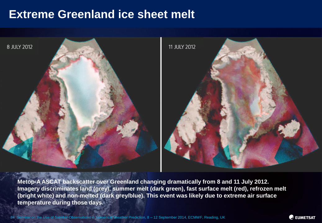
Extreme Greenland ice sheet melt
Metop-A ASCAT backscatter over Greenland changing dramatically from 8 and 11 July 2012.
Imagery discriminates land (grey), summer melt (dark green), fast surface melt (red), refrozen melt
(bright white) and non-melted (dark grey/blue). This event was likely due to extreme air surface
temperature during those days.

85 Seminar on the Use of Satellite Observations in Numerical Weather Prediction, 8 – 12 September 2014, ECMWF, Reading, UK
Winter storm Nicolas
Winter storm "Nicolas": DWD 45-hour forecasts of surface pressure (contour lines) and surface wind
speed (shaded areas - units m/s) for 7 February 2011, 21:00 UTC with (left) and without (right) Metop
observations, compared to operational analysis (best approximation of ground truth, centre)

86 Seminar on the Use of Satellite Observations in Numerical Weather Prediction, 8 – 12 September 2014, ECMWF, Reading, UK
Winter storm “Nicolas”: 45 hour forecasts and operational analysis (best approximation of ground truth) of surface
pressure (contour lines) and 10m wind speed (shaded areas – units M/S) for 7 February 2011
Failing to forecast major storms without Metop-A

87 Seminar on the Use of Satellite Observations in Numerical Weather Prediction, 8 – 12 September 2014, ECMWF, Reading, UK
Hurricane Sandy
Five-day forecast of cyclone Sandy landfall on the US coast by the ECMWF global model, with (left)
and without (right) ingestion of observations from polar orbiting satellites, compared to the
operational analysis (best approximation of ground truth, centre)