technologies and applications of geophysical exploration ... · technologies and applications of...
TRANSCRIPT
Proceedings World Geothermal Congress 2015
Melbourne, Australia, 19-25 April 2015
1
Technologies and Applications of Geophysical Exploration in Deep Geothermal Resources in
China
Long Hui, Zhu Qingjun, Tian Puyuan and Hu Wenguang
Centre for Hydrogeology and Environmental Geology Survey (China Geological Survey)
Qiyi Middle Road 1305, Baoding 071051, CHINA
Keywords: deep geothermal resources; geophysical exploration; combining method; geophysical response
ABSTRACT
According to the geophysical responses of deep geothermal resources, the geophysical techniques of geothermal exploration in
China are categorized into thermal infrared remote sensing, gravity survey, magnetic survey, electrical methods, seismic survey,
and well logging. On the basis of the previous study of geophysical exploration in high temperature geothermal fields and active
geothermal areas in China, the paper summarizes a variety of geophysical methods in geothermal exploration and the relationship
between these methods and the geothermal anomalies. The paper also compares the depths and precision of investigations, the
range of applicability, and the advantages and disadvantages of these methods. To compensate the shortages of using a single
method, the combined method has been proposed for geophysical exploration of deep geothermal resources which can not only
reduce the blindness of deep geothermal explorations effectively, but also improve the accuracy of exploration results, as well as
reduce the risk and cost in explorations at the same time.
1. INTRUDUCTION
Geophysical exploration of geothermal resources is to use specialized equipment to detect the physical fields related to the
geological structures and characteristics of a geothermal system. The temperature-sensitive physical parameters obtained by
geophysical methods are used to find the geothermal prospect areas, evaluate the characteristics of the geothermal system, delineate
the drilling area, locate the aquifers, and provide the basis for locating the borehole position. Compared to other fields, the
geophysical exploration in geothermal resources is focused on the geology and the structure of geothermal fluids or hot dry rocks,
and pays more attentions to some parameters which are particularly sensitive to the temperature. The geological background of
geothermal resources in China is quite complex compared with that in Iceland, New Zealand, and other countries. Therefore, many
things need to be determined before the exploration and the development, including the distribution and occurrence of regional
faults especially those related to geothermal fluids, the distribution, size and nature of the igneous intrusive bodies, the location of
geothermal reservoirs, and so on. Because there are multiple solutions existing in geophysical methods and each method has its
own specific scope, a single method cannot meet the needs of the geothermal exploration. An optimal method or a combining
method based on the different geological backgrounds in China is required in order to carry out the exploration of geothermal
resources economically and effectively.
2. THE PRESENT SITUATION AND MAIN PROBLEMS IN DEEP GEOTHERMAL EXPLORATION IN CHINA
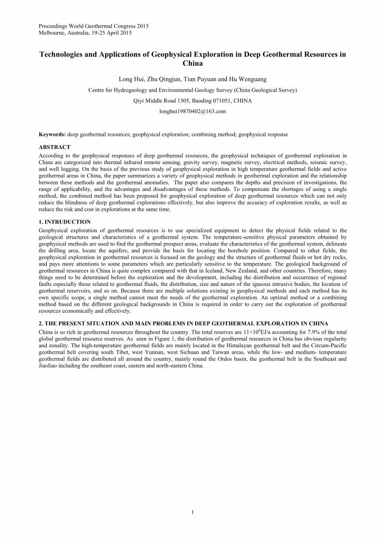
China is so rich in geothermal resources throughout the country. The total reserves are 11×106EJ/a accounting for 7.9% of the total
global geothermal resource reserves. As seen in Figure 1, the distribution of geothermal resources in China has obvious regularity
and zonality. The high-temperature geothermal fields are mainly located in the Himalayan geothermal belt and the Circum-Pacific
geothermal belt covering south Tibet, west Yunnan, west Sichuan and Taiwan areas, while the low- and medium- temperature
geothermal fields are distributed all around the country, mainly round the Ordos basin, the geothermal belt in the Southeast and
Jiaoliao including the southeast coast, eastern and north-eastern China.
Hui et al.
2
Figure 1: The distribution map of geothermal resources in China
China has a large number of geothermal resource reserves whether high-temperature or low- and medium-temperature, most of
which have been speculated or verified the existence of deep heat source and high-temperature geothermal reservoirs, but the
technologies of geophysical exploration and utilization in deep geothermal resources is still low-levelled and inefficient at present.
The Yangbajin geothermal field in Tibet is the only deep high-temperature geothermal reservoir exploited and utilized in China.
The geophysical technology is comparatively more mature in China for the geothermal exploration at a depth within 2000m b.s.l.,
but the country lacks effective and economic methods to explore the geothermal resources at a depth of more than 2000m b.s.l.
under the current economic and technological conditions. The followings are some problems existing in the exploration and the
development of deep geothermal resources.
2.1 The low level of exploration and evaluation of geothermal resources in China
As Chinese government invested too little in the exploration of the geothermal resources nationwide before 2013, most of the areas
were yet carried out the exploration, especially the low-temperature geothermal resources in western China. Though a few areas
had been explored, the geophysical technologies were not suitable for the exploitation and utilization due to the limitation of
economic and technical conditions at that moment. The data published officially by China's Ministry of Land and Resources
showed that the total resource of hot dry rock at the depth of between 3,000 and 10,000 m in mainland China was equivalent to
260,000 times of the whole year energy consumption in 2012(Wang, 2013). Realizing such a huge amount of geothermal resources
and the importance of early exploration and evaluation, the exploration of deep geothermal resources was officially initiated in
2013 by China's Ministry of Land and Resources for the purpose of investigating the thermal-controlled structures and the
distribution of heat-controlled rocks, delineating the potential areas of high-temperature geothermal fields, and drilling a
geothermal borehole with 3000 m depth. The exploration does not only brings dawn for the national geothermal explorations and
provides an opportunity for deep geothermal explorations, but also builds the foundation to realize the sustainable development and
utilization of geothermal resources.
2.2 The deep heat resources exist in most areas of China, a small amount of deep geothermal reservoirs have been validated
Plenty of evidence detected by the measured borehole temperature, geophysical and geochemical methods indicate that most areas
of China own deep heat sources, and a small amount of deep geothermal reservoirs have been verified. For example, the boreholes
ZK4002 with the drilling depth of 2006.8m b.s.l. and ZK4001 with the drilling depth of 1459m b.s.l. were drilled in Yangbajain
geothermal field in 1993 and 1996respectively , the wellhead temperature were 329℃ and 200℃ respectively (Jin, 1996)(Wang
and Chen, 1999). One of the boreholes in Naqu geothermal field in Tibet encountered a blowout when drilling to the depth of 60m
b.s.l. and the fluid temperature was 93℃ in 1984 (Liu and Wu, 1989). A blowout also occurred in one borehole in Rehai
geothermal field at 26m b.s.l. depth, the bottom-hole temperature was 145℃ in July 1976 (Zhang and Duan, 2005). The MT results
showed that an abnormally-high-conductivity layer was present in the geothermal field at the depth of 6,000~25,000m b.s.l.
possibly representing partial melting of magma capsule. Investigation on volcanic cluster in Wudalianchi located in Heilongjiang
Province by MT suggested that the rivet-like, high resistance anomaly body at the depth of a few hundred meters underground to
15,000-20,000m b.s.l. appeared to be a high-temperature volcanic slurry (Zhan et al., 1999). A large number of facts show that most
areas of China are abundant in deep geothermal resources, which will provide the direction to study deep geothermal reservoir and
explore deep geothermal resources.
2.3 The exploration depth is not enough, and the geological structures and resources at deep depth fail to identify
At present, the largest geothermal exploration depth in China is more than 3,600 m. The highest temperature is above 250℃ in
ZK4001 in Yangbajain geothermal field, but other boreholes cannot reach this temperature. Guangdong is one of the provinces that
have abundant geothermal resources and hot springs. The number of hot springs whose temperatures are more than 30℃ found here
Hui et al.
3
is about 320, accounting for 10% of the total national number (Tian, 2012). Only Fengshun County alone has 16 hydrothermal-
active regions where the water flows are large and the depth of burials are shallow. They can be utilized directly without
exploration by the mean of pumping water from shallow boreholes. This is limited to shallow depth in the geological exploration,
as well as makes it difficult to study the deep structures, the existence of deep heat source and the storage form of geothermal
reservoir.
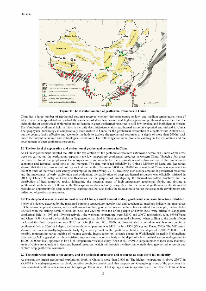
2.4 Fail to adopt cascade utilization pattern, low efficiency of exploitation and utilization cause serious waste of resources
Currently, only Yangbajin, Huitang, Dengwu and Houhaoyao geothermal fields are used to generate electricity, others are used
directly and have many problems, such as low efficiency, irrational structures, serious pollutions and other issues. The adequate,
scientific and efficient utilization pattern is the Icelandic cascade utilization pattern showed in Figure 2 which China has not taken.
For example, Guangdong possess a lot of high-temperature geothermal resources which has a great potential of generating
electricity, but all of them adopt single utilization mode leading to serious waste of the resource.
Figure 2: The cascade utilization pattern of geothermal resources in Iceland
3. GEOPHYSICAL METHODS IN GEOTHERMAL EXPLORATION AND APPLICATIONS IN CHINA
According to the existing form, the deep geothermal resources have hydrothermal type and hot dry rocks. The former is the vapor
and liquid water dominated geothermal resources while the latter is hot dry rock and magma based geothermal resources. The
water-dominated geothermal resources has been exploiting and utilizing widely in China. The geophysical methods of
hydrothermal geothermal resources are relatively mature, including thermal infrared remote sensing technology, gravity survey,
magnetic survey, electrical methods, seismic survey and well logging. Comparatively electrical methods contain more and apply
widely, such as induced polarization, DC sounding, spontaneous potential, magnetotelluric sounding, transient electromagnetic
method and controlled source audio frequency magnetotelluric.
3.1 Thermal Infrared Remote Sensing Technology
Thermal infrared remote sensing technology is a new technology to detect the surface temperature which can obtain the ground
temperature of a large area quickly and provide the location of hot springs and the distribution of thermal anomaly accurately. The
United States is the first country in the world that uses thermal infrared remote sensing technology in geothermal exploration,
followed by New Zealand, Iceland, Mexico, Ethiopia, Japan and China. The method has been carried out in geothermal
investigation in Tianjin, Fujian and Liaoning of China. The facts have been proved that thermal infrared remote sensing technology
is an effective technique in geothermal exploration, but it cannot replace conventional technologies. It must be compatible with
other geophysical methods in order to obtain better results.
3.2 Gravity Survey
As a typical method to identify geological structure, gravity is used for determining the top and bottom interfaces of bedrock,
studying the spatial distribution of fault structure and delineating faults, fractures and intrusions (Zhou, 1998). High accuracy
gravity survey is involved in geothermal exploration in recent years not only because of the improved requirement of accuracy, but
also because it can accurately reflect the fractures based on different density of the underground substance. On the basis of practical
research of high accuracy gravity survey carried out in New Zealand, the United States and Japan, it has been applied in
Yangbajing, Wudalianchi, Tengchong, Beijing and other places in China shows the good corresponding relationship between
geothermal manifestation and gravity anomalies. The increasing density caused by thermometamorphism appears positive gravity
anomalies, but in vapor-dominated geothermal reservoir, the decreasing density and more fissures show negative gravity anomalies.
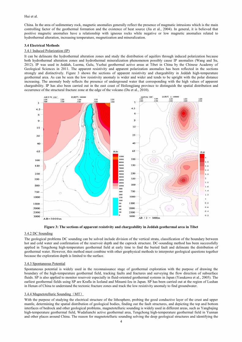
3.3 Magnetic Survey
Magnetic survey is generally used to draw the geological structures together with gravity and seismic surveys, study the faults and
fractures, determine the alteration zone and the fracture zone, as well as classify the distribution of sedimentary, intrusive, extrusive
and metamorphic rocks. Magnetic survey is widely and successfully used in Anqing, Tangshangtun, Qixianwang and other areas in
Water/brine
Steam
20
40
60
80
100
120
140
160
180
200
220
℃
Temperature
Electricity
(flash)
Electricity
(binary)Industrial
(e.g. drying)
Balneo
therapy
Freezing
Space cooling
Soil heating
Snow melting
Space
heatingFish
farming
Green houses
(agriculture)
Hui et al.
4
China. In the area of sedimentary rock, magnetic anomalies generally reflect the presence of magmatic intrusions which is the main
controlling factor of the geothermal formation and the existence of heat source (Jia et al., 2004). In general, it is believed that
positive magnetic anomalies have a relationship with igneous rocks while negative or low magnetic anomalies related to
hydrothermal alteration, increasing temperature, megnetization and mineralization.
3.4 Electrical Methods
3.4.1 Induced Polarization (IP)
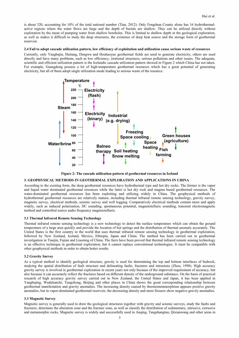
It can be delineate the hydrothermal alteration zones and study the distribution of aquifers through induced polarization because
both hydrothermal alteration zones and hydrothermal mineralization phenomenon possibly cause IP anomalies (Wang and Su,
2012). IP was used in Jeddah, Luoma, Gulu, Yuzhai geothermal active areas at Tibet in China by the Chinese Academy of
Geological Sciences in 2011. The apparent resistivity and apparent polarization anomalies has been reflected in the sections
strongly and distinctively. Figure 3 shows the sections of apparent resistivity and chargeability in Jeddah high-temperature
geothermal area. As can be seen the low resistivity anomaly is wider and wider and tends to be upright with the polar distance
increasing. The anomaly body reflects the presence of underground water that corresponding with the high values of apparent
chargeability. IP has also been carried out in the east coast of Heilongjiang province to distinguish the spatial distribution and
occurrence of the structural fracture zone at the edge of the volcano (Du et al., 2010).
Figure 3: The sections of apparent resistivity and chargeability in Jeddah geothermal area in Tibet
3.4.2 DC Sounding
The geological problems DC sounding can be solved include division of the vertical strata, classification of the boundary between
hot and cold water and confirmation of the reservoir depth and the caprock structure. DC-sounding method has been successfully
applied in Tengchong high-temperature geothermal field at early time to find the buried fault and delineate the distribution of
geothermal water. However, this method must combine with other geophysical methods to interpreter geological questions together
because the exploration depth is limited to the surface.
3.4.3 Spontaneous Potential
Spontaneous potential is widely used in the reconnaissance stage of geothermal exploration with the purpose of drawing the
boundary of the high-temperature geothermal field, tracking faults and fractures and surveying the flow direction of subsurface
fluids. SP is also applied to monitor reservoir especially in fluid-oriented geothermal systems in Japan (Yasukawa et al., 2005). The
earliest geothermal fields using SP are Krafla in Iceland and Minami-Izu in Japan. SP has been carried out at the region of Lushan
in Henan of China to understand the tectonic fracture zones and track the low resistivity anomaly to find groundwater.
3.4.4 Magnetotelluric Sounding(MT)
With the purpose of studying the electrical structure of the lithosphere, probing the good conductive layer of the crust and upper
mantle, determining the spatial distribution of geological bodies, finding out the fault structures, and depicting the top and bottom
interfaces of bedrock and other geological problems, magnetotelluric sounding is widely used in different areas, such as Yangbajing
high-temperature geothermal field, Wudalianchi active geothermal area, Tengchong high-temperature geothermal field in Yunnan
and other places around China. The reason for magnetotelluric sounding solving the deep geological structures and identifying the
Hui et al.
5
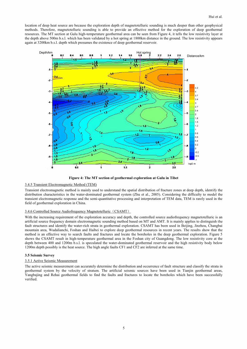
location of deep heat source are because the exploration depth of magnetotelluric sounding is much deeper than other geophysical
methods. Therefore, magnetotelluric sounding is able to provide an effective method for the exploration of deep geothermal
resources. The MT section at Gulu high-temperature geothermal area can be seen from Figure 4, it tells the low resistivity layer at
the depth above 500m b.s.l. which has been validated by a hot spring at 1800km distance in the ground. The low resistivity appears
again at 3200km b.s.l. depth which presumes the existence of deep geothermal reservoir.
Figure 4: The MT section of geothermal exploration at Gulu in Tibet
3.4.5 Transient Electromagnetic Method (TEM)
Transient electromagnetic method is mainly used to understand the spatial distribution of fracture zones at deep depth, identify the
distribution characteristics in the water-dominated geothermal system (Zhu et al., 2005). Considering the difficulty to model the
transient electromagnetic response and the semi-quantitative processing and interpretation of TEM data, TEM is rarely used in the
field of geothermal exploration in China.
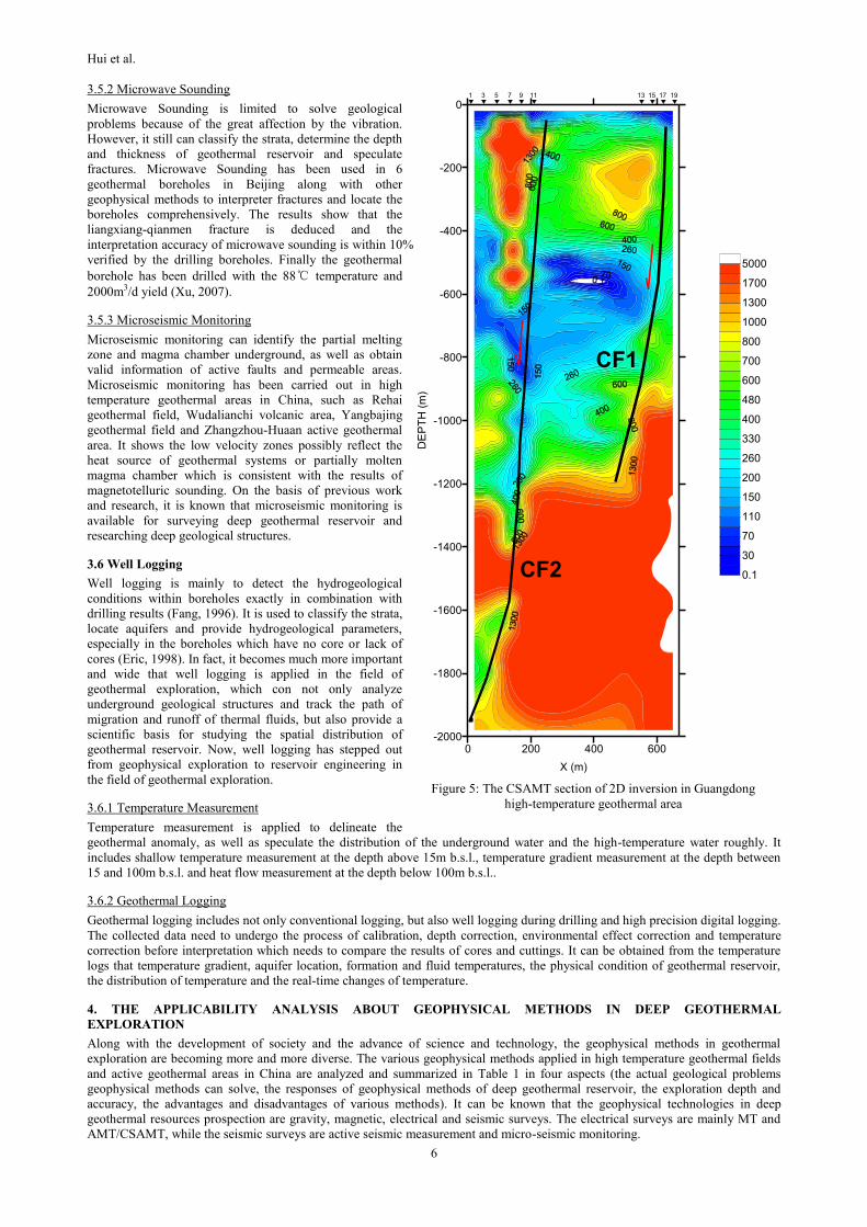
3.4.6 Controlled Source Audiofrequency Magnetotelluric(CSAMT)
With the increasing requirement of the exploration accuracy and depth, the controlled source audiofrequency magnetotelluric is an
artificial source frequency domain electromagnetic sounding method based on MT and AMT. It is mainly applies to distinguish the
fault structures and identify the water-rich strata in geothermal exploration. CSAMT has been used in Beijing, Jinzhou, Changbai
mountain area, Wudalianchi, Foshan and Haibei to explore deep geothermal resources in recent years. The results show that the
method is an effective way to search faults and fractures and locate the boreholes in the deep geothermal exploration. Figure 5
shows the CSAMT result in high-temperature geothermal area in the Foshan city of Guangdong. The low resistivity core at the
depth between 400 and 1200m b.s.l. is speculated the water-dominated geothermal reservoir and the high resistivity body below
1200m depth possibly is the heat source. The high angle faults CF1 and CF2 are inferred at the same time.
3.5 Seismic Survey
3.5.1 Active Seismic Measurement
The active seismic measurement can accurately determine the distribution and occurrence of fault structure and classify the strata in
geothermal system by the velocity of stratum. The artificial seismic sources have been used in Tianjin geothermal areas,
Yangbajing and Rehai geothermal fields to find the faults and fractures to locate the boreholes which have been successfully
verified.
Depth/km Distance/km
Hot spring
Hui et al.
6
3.5.2 Microwave Sounding
Microwave Sounding is limited to solve geological
problems because of the great affection by the vibration.
However, it still can classify the strata, determine the depth
and thickness of geothermal reservoir and speculate
fractures. Microwave Sounding has been used in 6
geothermal boreholes in Beijing along with other
geophysical methods to interpreter fractures and locate the
boreholes comprehensively. The results show that the
liangxiang-qianmen fracture is deduced and the
interpretation accuracy of microwave sounding is within 10%
verified by the drilling boreholes. Finally the geothermal
borehole has been drilled with the 88℃ temperature and
2000m3/d yield (Xu, 2007).
3.5.3 Microseismic Monitoring
Microseismic monitoring can identify the partial melting
zone and magma chamber underground, as well as obtain
valid information of active faults and permeable areas.
Microseismic monitoring has been carried out in high
temperature geothermal areas in China, such as Rehai
geothermal field, Wudalianchi volcanic area, Yangbajing
geothermal field and Zhangzhou-Huaan active geothermal
area. It shows the low velocity zones possibly reflect the
heat source of geothermal systems or partially molten
magma chamber which is consistent with the results of
magnetotelluric sounding. On the basis of previous work
and research, it is known that microseismic monitoring is
available for surveying deep geothermal reservoir and
researching deep geological structures.
3.6 Well Logging
Well logging is mainly to detect the hydrogeological
conditions within boreholes exactly in combination with
drilling results (Fang, 1996). It is used to classify the strata,
locate aquifers and provide hydrogeological parameters,
especially in the boreholes which have no core or lack of
cores (Eric, 1998). In fact, it becomes much more important
and wide that well logging is applied in the field of
geothermal exploration, which con not only analyze
underground geological structures and track the path of
migration and runoff of thermal fluids, but also provide a
scientific basis for studying the spatial distribution of
geothermal reservoir. Now, well logging has stepped out
from geophysical exploration to reservoir engineering in
the field of geothermal exploration.
3.6.1 Temperature Measurement
Temperature measurement is applied to delineate the
geothermal anomaly, as well as speculate the distribution of the underground water and the high-temperature water roughly. It
includes shallow temperature measurement at the depth above 15m b.s.l., temperature gradient measurement at the depth between
15 and 100m b.s.l. and heat flow measurement at the depth below 100m b.s.l..
3.6.2 Geothermal Logging
Geothermal logging includes not only conventional logging, but also well logging during drilling and high precision digital logging.
The collected data need to undergo the process of calibration, depth correction, environmental effect correction and temperature
correction before interpretation which needs to compare the results of cores and cuttings. It can be obtained from the temperature
logs that temperature gradient, aquifer location, formation and fluid temperatures, the physical condition of geothermal reservoir,
the distribution of temperature and the real-time changes of temperature.
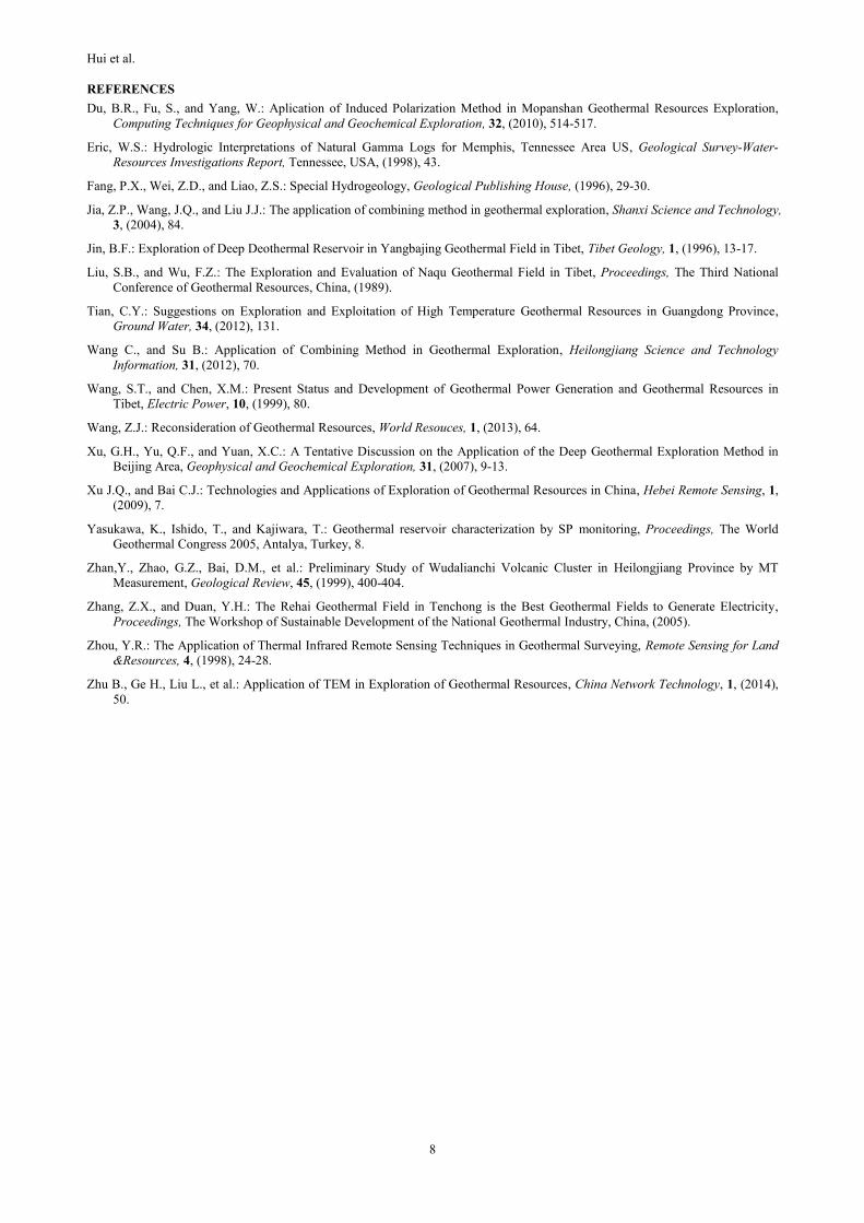
4. THE APPLICABILITY ANALYSIS ABOUT GEOPHYSICAL METHODS IN DEEP GEOTHERMAL
EXPLORATION
Along with the development of society and the advance of science and technology, the geophysical methods in geothermal
exploration are becoming more and more diverse. The various geophysical methods applied in high temperature geothermal fields
and active geothermal areas in China are analyzed and summarized in Table 1 in four aspects (the actual geological problems
geophysical methods can solve, the responses of geophysical methods of deep geothermal reservoir, the exploration depth and
accuracy, the advantages and disadvantages of various methods). It can be known that the geophysical technologies in deep
geothermal resources prospection are gravity, magnetic, electrical and seismic surveys. The electrical surveys are mainly MT and
AMT/CSAMT, while the seismic surveys are active seismic measurement and micro-seismic monitoring.
0 200 400 600
X (m)
-2000
-1800
-1600
-1400
-1200
-1000
-800
-600
-400
-200
0
DE
PT
H (
m)
0.1
30
70
110
150
200
260
330
400
480
600
700
800
1000
1300
1700
5000
1 3 5 7 9 11 13 15 17 19
CF2
CF1
Figure 5: The CSAMT section of 2D inversion in Guangdong
high-temperature geothermal area
Hui et al.
7
Table 1: Adaptability analysis of geophysical methods
Geophysical Methods Geophysical Response Depth Advantages and Disadvantages
Thermal infrared remote
sensing technique
The waveband,
temperature gradient Surface
A: Continuous sampling, large amount of information, good consistency and intuitive
image, high precision, high speed, low cost;
D: Restrictive, disruptive, shallow depth;
Gravity survey Positive or negative
gravity abnormality
>hundreds
of meters
A: Reflect the fracture accurately, deep exploration depth ;
D: Low exploration precision, topographic correction is required, suitable for large area
Magnetic survey Positive or negative magnetic abnormality
>hundreds of meters
A: Deep detecting depth, simple operation, low cost, strong reaction to magnetic anomaly D: Liable to disturb, too many impact factors;
electrical
methods
IP High value 0.5km A: Display aquifers directly, less affected by the terrain;
D: Shallow depth;
DC sounding Low resistivity 0.5km A: Simple operation, display directly, simple interpretation ;
D: Vulnerable to interfere, high resistance to produce shielding;
SP Positive or negative
resistivity abnormality Surface
A: Simple, quick, intuition;
D: Stay in reconnaissance stag, shallow depth;
MT Low resistivity 10~30km
A: Simple data collection, instruments easy to carry, deep depth;
D: Poor anti-noise performance, sensitive to electrical wires, difficult to interpret detailed
(2D or 3D);
TEM Low resistivity 1km
A: Save manpower and cost, little affected by the topography, high resolution, simple
explanation, strong penetrability;
D: Complex instrument operation, data need to be transformed, inaccurate abnormal
location, large electromagnetic interference;
AMT/CSAMT Low resistivity 2km
A: High signal-to-noise ratio, high horizontal resolution, small static distortion, light
equipment, anti-interference, high efficiency;
D: Greatly influenced by the terrain and electrical power, cause static displacement, need
terrain correction in data processing and interpretation;
Seismic
survey
Active
Seismic
Measurement
Low velocity 5km
A: No limit to the high resistance shielding, high precision, high lateral resolution
D: Large equipment, long work periodically, manpower, much more manpower,
investment and materials
Microwave
Sounding Low velocity 0.05~3km
A: Flexible sensors, small electromagnetic interference, high interpretation accuracy and deep exploration depth;
D: Large volume effect, ineffectively two-dimensional interpretation, big influence of
environment;
Micro-seismic
monitoring Low velocity 30km
A: Deep depth, high resolution and low cost;
D: Long duration, complex data processing, time-consuming and laborious;
Well
logging
Temperature
measurement
High temperature
High T gradient Surface
A: Fast, accurate, simple and direct operation ;
D: Shallow depth;
Geothermal
logging real-time measure —
A: High vertical resolution ;
D: High demands on equipment;
5. COMBINING METHOD OF GEOPHYSICAL METHODS
Essentially, the geophysical exploration measures horizontally and vertically the underground geological body by various methods
to understand the internal structure and characteristics. The combining method needs to choose different kinds of geophysical
methods reasonably for different geological tasks. The technical route of the combining method in deep geothermal exploration in
China has been summarized as followings:
Firstly, collect the regional geological data, especially the information about oil fields and coal fields in or near the study area. The
known borehole data can be treated as a reference to divide the stratum.
Secondly, analyze the geological characteristics of geothermal resources, and delineate a wide range of geothermal exploration area
based on the result of thermal infrared remote sensing technology, and then predict the top and bottom interfaces of bedrock and the
spatial distribution of fault structure used gravity and magnetic surveys.
Thirdly, analyze the distribution and occurrence of faults and fractures; infer their position and size; then propose the location of
boreholes based on the interpretation results of electrical and seismic surveys.
Finally, forecast the development of fractures and the location of aquifers using the logged data combined with geothermal
reservoir model and low resistivity anomaly zone in resistivity sections. Moreover, delineate the position and the size of geothermal
reservoir and verify the borehole location. In the end, verify the results of geophysical exploration through drilling geothermal
boreholes.
6. CONCLUSIONS
(1) China is rich in deep geothermal resources, part of which has been confirmed. Insufficiency of the exploration depth and
ambiguity of the geological structures and resources cause a lot of problems, such as low degree of exploration and evaluation, low
utilization efficiency, waste of geothermal resources and other serious issues.
(2) The theory and practice of geophysical exploration methods of geothermal resources in China has gradually matured for the
drilling depth of within 2,000 m b.s.l., while for the depth of over 2,000 m b.s.l. they lack experiences and skills.
(3) It has been analyzed and summarized from various aspects that the geophysical technologies in deep geothermal exploration
mainly include gravity survey, magnetic survey, MT and AMT/CSAMT, active seismic measurement and micro-seismic
monitoring. On the basis of these geophysical methods, the combining method has been concluded and proposed for general
application.
Hui et al.
8
REFERENCES
Du, B.R., Fu, S., and Yang, W.: Aplication of Induced Polarization Method in Mopanshan Geothermal Resources Exploration,
Computing Techniques for Geophysical and Geochemical Exploration, 32, (2010), 514-517.
Eric, W.S.: Hydrologic Interpretations of Natural Gamma Logs for Memphis, Tennessee Area US, Geological Survey-Water-
Resources Investigations Report, Tennessee, USA, (1998), 43.
Fang, P.X., Wei, Z.D., and Liao, Z.S.: Special Hydrogeology, Geological Publishing House, (1996), 29-30.
Jia, Z.P., Wang, J.Q., and Liu J.J.: The application of combining method in geothermal exploration, Shanxi Science and Technology,
3, (2004), 84.
Jin, B.F.: Exploration of Deep Deothermal Reservoir in Yangbajing Geothermal Field in Tibet, Tibet Geology, 1, (1996), 13-17.
Liu, S.B., and Wu, F.Z.: The Exploration and Evaluation of Naqu Geothermal Field in Tibet, Proceedings, The Third National
Conference of Geothermal Resources, China, (1989).
Tian, C.Y.: Suggestions on Exploration and Exploitation of High Temperature Geothermal Resources in Guangdong Province,
Ground Water, 34, (2012), 131.
Wang C., and Su B.: Application of Combining Method in Geothermal Exploration, Heilongjiang Science and Technology
Information, 31, (2012), 70.
Wang, S.T., and Chen, X.M.: Present Status and Development of Geothermal Power Generation and Geothermal Resources in
Tibet, Electric Power, 10, (1999), 80.
Wang, Z.J.: Reconsideration of Geothermal Resources, World Resouces, 1, (2013), 64.
Xu, G.H., Yu, Q.F., and Yuan, X.C.: A Tentative Discussion on the Application of the Deep Geothermal Exploration Method in
Beijing Area, Geophysical and Geochemical Exploration, 31, (2007), 9-13.
Xu J.Q., and Bai C.J.: Technologies and Applications of Exploration of Geothermal Resources in China, Hebei Remote Sensing, 1,
(2009), 7.
Yasukawa, K., Ishido, T., and Kajiwara, T.: Geothermal reservoir characterization by SP monitoring, Proceedings, The World
Geothermal Congress 2005, Antalya, Turkey, 8.
Zhan,Y., Zhao, G.Z., Bai, D.M., et al.: Preliminary Study of Wudalianchi Volcanic Cluster in Heilongjiang Province by MT
Measurement, Geological Review, 45, (1999), 400-404.
Zhang, Z.X., and Duan, Y.H.: The Rehai Geothermal Field in Tenchong is the Best Geothermal Fields to Generate Electricity,
Proceedings, The Workshop of Sustainable Development of the National Geothermal Industry, China, (2005).
Zhou, Y.R.: The Application of Thermal Infrared Remote Sensing Techniques in Geothermal Surveying, Remote Sensing for Land
&Resources, 4, (1998), 24-28.
Zhu B., Ge H., Liu L., et al.: Application of TEM in Exploration of Geothermal Resources, China Network Technology, 1, (2014),
50.