technology enabling -...
TRANSCRIPT

An Overview of NASA Earth Science TechnologySPRING 2018 MEETING OF THECOMMITTEE ON EARTH SCIENCE AND APPLICATIONS FROM SPACE NATIONAL ACADEMIES OF SCIENCE
March 28, 2018 • Washington, DC
Pamela Millar, Program DirectorRobert Bauer, Deputy Program Director
Michael Little, Lead, Advanced Information SystemsEarth Science Technology Office (ESTO)
Technology Enabling

Outline An Overview of the Earth Science Technology Program
Results and Selected Accomplishments Following the 2007 Decadal Survey
Realizing the 2017 Decadal Survey – Technology for New Observations
Emerging Technologies – Advanced Sensors and Information Systems Technologies

OverviewEarth Science Technology Program

SMDOrg
Chart

ESTOOrg
ChartEARTH SCIENCE TECHNOLOGY OFFICE (ESTO)
5
A Flexible, Science-driven Strategy• Competitive, peer-reviewed proposals enable selection of best-of-class technology investments
• Risks are retired before major dollars are invested: a cost-effective approach to technology development and validation
• Successful partnering establishes leveraging opportunities
• This approach has resulted in:
- a portfolio of emerging technologies that will enhance and/or enable future science measurements
- a growing number of infusion successes into science campaigns, instruments, applications, ground systems, and missions
ESTO Enables – Science Selects
6

Instrument Incubator Program (IIP)innovative remote sensing instrument development from concept throughbreadboard and demonstration (average award: $1.5M per year over three years)
Advanced Information Systems Technology (AIST)innovative on-orbit and ground capabilities for communication, processing, and management of remotely sensed data and the efficient generation of data products (average award: $600K per year over two years)
ESTO manages, on average, 120 active technology development projects. Most are funded through the primary program lines below. Nearly 800 projects have completed since 1998.
Advanced Component Technologies (ACT)critical components and subsystems for advanced instruments and observing systems(average award: $300K per year over two/three years)
In-Space Validation of Earth Science Technologies (InVEST)on-orbit technology validation and risk reduction for small instruments and instrument systems that could not otherwise be fully tested on the ground or airborne systems (average award: $1-1.8M per year over three years)
Earth Science Technology Program ElementsAdvanced Technology Initiatives (ATI)
7

($M, FY17 Budget) FY16 FY17 FY18 FY19 FY20 FY21 FY22 FY23Q 1 2 3 4 1 2 3 4 1 2 3 4 1 2 3 4 1 2 3 4 1 2 3 4 1 2 3 4 1 2 3 4
ROSES Solicitations
ATI – ACT & InVEST Solicitation NRA Release
ACT-17 InVEST-17 ACT-20 InVEST-21 ACT-23
Budget 18.1 20.1 17.7 17.0 19.0 21.3 22.0 22.6
IIP SolicitationNRA Release
IIP-16 IIP-19 IIP-22
Budget 28.3 28.6 28.6 28.6 28.5 28.8 30.7 31.5
AIST SolicitationNRA Release
AIST-16 AIST-18 AIST-20 AIST-22
Budget 14.3 14.1 14.1 14.1 14.0 14.1 15.1 15.5
In-Guide Totals ($M) 60.7 62.8 60.4 59.7 61.5 64.2 67.8 69.6
Total ESD Budget ($M) $1,926 $1,907 $1,754 $1,784 $1,784 $1,784 $1,784 $1,784
% of ESD Budget 3.2% 3.3% 3.4% 3.3% 3.5% 3.6% 3.8% 3.9%
Technology Program Budget and Notional Schedule
8

ESTO also manages specific sets of technology development and integration projects on behalf of the ESD Research and Flight programs. Other ESD Technology Activities Managed by ESTO
Airborne Instrument Technology Transition (AITT)provides campaign ready airborne instrumentation to support the objectives of the R&A Program. AITT converts mature instruments into operational suborbital assets that can participate in field experiments, evaluate new satellite instrument concepts, and/or provide calibration and validation of satellite instruments. (average award: $1M)
Rese
arch
& A
nalys
isFl
ight
Ocean Biology and Biogeochemistry: Ocean Color Remote Sensing Vicarious Calibration Instrumentsin situ vicarious calibration instrument systems to maintain global climate-quality ocean color remote sensing of radiances and reflectances (average award: $2.3M)
Earth Venture Instruments – Technologyfunding from the Flight Program’s Earth Systems Science Pathfinder (ESSP) program to further develop promising, highly-rated Earth Venture proposals that require additional technology risk reductions (average award: $5 - 8M)
Sustainable Land Imaging-Technology (SLI-T)new technologies and reduced costs for future land imaging (Landsat) measurementsFirst solicitation released in FY16 (average award: $3-7M )
9

ESTO
FY1
7 Pr
ojec
t Sta
ts
10

26%
41%
35%
52%
39%
28%
39%36%
41%
46%
53%
37%
50%
40%
29%
54%
40%
34%
57%
0%
10%
20%
30%
40%
50%
60%
FY99 FY00 FY01 FY02 FY03 FY04 FY05 FY06 FY07 FY08 FY09 FY10 FY11 FY12 FY13 FY14 FY15 FY16 FY17
25% Goal
ESTO’s all-time infusion success, drawn from 775 completed projects through the end of FY17. In this fiscal year, at least 10 ESTO projects
achieved infusion into science measurements, airborne campaigns, data systems, or follow-on development activities.
FY17 Program Metrics
57% of ESTO technology projects funded during FY17 advanced one or more TRLs over the course of the fiscal year (16 advanced more than one TRL). The average TRL advancement for all years is 41%.
TRL Advancement
TechnologyInfusion
43% Path Identified for Infusion
23% Awaiting Infusion Opportunity
34% Already Infused
11

(Pre)FormulationImplementationPrimary OpsExtended Ops
ISS InstrumentsLIS (2020), SAGE III (2020)TSIS-1 (2018), OCO-3 (2018), ECOSTRESS (2018), GEDI (2018)CLARREO-PF (2020)
NASA Earth Science Missions: Present through 2023
Landsat 9 (2020)PACE (2022)
NI-SAR (2021)SWOT (2021)
TEMPO (2018)GRACE-FO (2) (2018)
ICESat-2 (2018)CYGNSS (8) (2019)
NISTAR, EPIC(DSCOVR / NOAA) (2019)
QuikSCAT(2017)
Landsat 7(USGS) (~2022)Terra (>2021)
Aqua (>2022)
CloudSat (~2018)CALIPSO (>2022)
Aura (>2022)
SMAP (>2022)
Suomi NPP (NOAA) (>2022)
Landsat 8(USGS) (>2022)
GPM (>2022)
OCO-2 (>2022)
Sentinel-6A/B (2020, 2025)MAIA (~2021)
GeoCARB (~2021)TROPICS (12) (~2021)
SORCE,TCTE (NOAA) (2017)
OSTM/Jason-2 (NOAA) (>2022)
JPSS-2 InstrumentsRBI (2018), OMPS-Limb (2018)
InVEST/CubeSatsRAVAN (2016)IceCube (2017)MiRaTA (2017)HARP (2018)TEMPEST-D (2018)RainCube (2018)CubeRRT (2018)CIRiS (2018*)CSIM (2018)
* Target date, not yet manifested
01.18.18

ESTO InVEST 2012 ProgramU-Class Satellites Advancing TRLs for Future Earth Science Measurements
IceCubeGSFC
Launched: March 2017
883 GHz submm-Wave radiometer
Validate sub-mm radiometer for spaceborne cloud ice remote sensing
HARPUMBC
Launch: 2018
Wide FOV Rainbow Polarimeter
Demonstrate 2-4 km wide FOV hyperangularpolarimeter for cloud & aerosol
characterization
MiRaTAMIT / MIT-LL
Launched: July 2017
3 Frequency Radiometer and GPSRO
Validate new microwave radiometer and GPSRO technology for all-weather
sounding
RAVANAPL
Launched: Nov 2016
Vertically Aligned Carbon Nanotubes (VACNTs)
Demonstrate VACNTs as radiometer absorbing material and calibration
standard for total outgoing radiation
Technology demonstrations mitigating risk and bridging the “Valley of Death” 13

ESTO InVEST 2015 Program / Venture TechU-Class Satellites Advancing TRLs for Future Earth Science Measurements
TEMPEST-DColorado State University
Launch: May 2018
5 Frequency mm-Wave RadiometerTechnology demonstrator measuring the
transition of clouds to precipitation
RainCubeJet Propulsion LabLaunch: May 2018
CubeRRTOhio State UniversityLaunch: May 2018
ESTO InVEST 2015 ProgramVenture Tech
CIRiSBall AerospaceLaunch: 2018
Precipitation RadarValidate a new architecture for Ka-band radars on CubeSat platform and an ultra-compact deployable Ka-band antenna
Radiometer RFIDemonstratewideband RFI mitigating backend technologies vital for future space-borne microwave radiometers
Infrared RadiometerValidate an uncooled imaging infrared (7.5 um to 13 um) radiometer designed for highradiometric performance from LEO
Technology demonstrations mitigating risk and bridging the “Valley of Death” 14

Results And Selected Accomplishments Since the 2007 Decadal Survey

Tier I Tier II Tier III
2007
-20
0920
10 -
2012
Instrument Technology Investments
Component Technology Investments
Information Systems Investments – Direct Applicability
Information Systems Investments – Secondary Applicabilityplanned aircraft testing planned balloon testing
(note: component and information systems investments may apply to more than one mission)
Upon publication of the Earth Science Decadal Survey in 2007, ESTO investments already supported all 18 of the recommended mission concepts. Enabling the 2007 Decadal Survey
16

2007 DS – Missions to Measurements
17

Component Technologies Enabling SWOTThe Surface Water Ocean Topography (SWOT) mission, targeted to launch in 2020, is intended to produce a better understanding of the world’s ocean topography and terrestrial surface waters at a much higher spatial resolution than currently available. Several ACT investments have advanced the technologies required for SWOT:
The design for SWOT includes two deployable, 5 meter, Ka-band reflectarrayantennas – part of the Ka-band Radar Interferometer (KaRIn) instrument – that need to be separated by 10 meters, structurally flat and thermally stable to meet demanding pointing requirements. This project built and tested a full-scale deployable reflectarray prototype (left) that has become the current baseline for the SWOT mission. (PI: M. Thompson, JPL, ACT-08, $1M)
A related project has designed and prototyped a precision deployable mast for the two KaRIn antennas, including the hinges and latches needed for precise space deployment. Shown is the mechanical drawing for a 180 degree hinge and latch. (PI: G. Agnes, JPL, ACT-10, $1.2M)
A key challenge for SWOT was a low-power, high bandwidth Ka-band receiver that is capable of making precision measurements over a wide bandwidth. This project has completed design and development of a single-stage Dual Down Converter (or DDC, shown here) that meets SWOT mission concept requirements. (PI: P. Siqueira, University of Mass, ACT-08, $1.1M)
18

Spaceborne microwave radiometers, such as on the Soil Moisture Active Passive (SMAP) mission, are susceptible to radio-frequency interference (RFI) from anthropogenic sources. SMAP utilizes an innovative onboard digital detector with digital signal processing algorithms to characterize received signals. An early technology project, awarded in 2004 under the Instrument Incubator Program (IIP), has helped form the basis for RFI detection on SMAP. The Agile Digital Detector (ADD) for RFI Detection and Mitigation was developed at the University of Michigan by Chris Ruf in partnership with Jeff Piepmeier at NASA GSFC and Joel Johnson at the Ohio State University. The system provided the algorithm theory and prototype software for the SMAP flight systemkurtosis detectors as well as the ground science processing. The SMAP radiometer is the first to enable complex RFI detection and mitigation in the ground software.(C. Ruf, Univ. of Michigan, IIP-04)A prototype brassboard of the Agile Digital Detector
(ADD). The ADD was also adopted and used by the Hurricane and Severe Storm Sentinel (HS3) airborne campaign with the Hurricane Imaging Radiometer (HIRAD) instrument to detect and mitigate RFI.
Technologies Supporting SMAP
Beginning in 2016, the Soil moisture Sensing Controller And oPtimal Estimator (SoilSCAPE) AIST project successfully installed and tested two new networks of in-situ soil temperature and moisture sensor webs at sites
in Alaska. The sensor webs – which have also been installed in California, Arizona, Michigan, and Oklahoma –are autonomous, wireless networks that provide near-real-time data for validation of airborne and spaceborne
instruments, including for the NASA Soil Moisture Active and Passive (SMAP) mission and the Arctic Boreal Vulnerability Experiment (ABoVE) airborne campaign. Several nodes of sensors were placed at the two Alaska sites. Each node contains soil probes at four depths below the tundra, from 5 cm below the surface to near the permafrost table. Data from the probes is gathered, wirelessly transmitted, re-transmits the data via cellular or
communications satellite, and made accessible online, at: http://soilscape.usc.edu(PI: M. Moghaddam, USC; AIST-14)
The SoilScape team installs sensors at the Happy Valley field site. The spongy, uneven surface, known as thermokarst, made walking exceptionally difficult.
19

A new inter-spacecraft laser ranging measurement system could lead to 10x better accuracy than the microwave ranging system currently employed by the Gravity Recovery and Climate Experiment (GRACE) mission.
Since 2002, GRACE has provided gravity measurements of Earth for many applications: from the melting of glaciers and polar ice caps to seasonal rainfall in the Amazon. In addition to the existing microwave ranging technique, the GRACE-Follow-On (GRACE-FO) mission (to launch in 2018) will include a demonstration of laser ranging.
The GRACE-FO mission is directly inheriting from this task a set of mature technologies for the laser ranging instrument.
PI: William Folkner, JPL, IIP-07, $3.4M
Optical cavity made out of ultra-low expansion glass Optical cavity to central ring mounted using flexures Engineering model of prototype
Improving Time-variable Gravity Measurements
20
Earth Venture Infusions
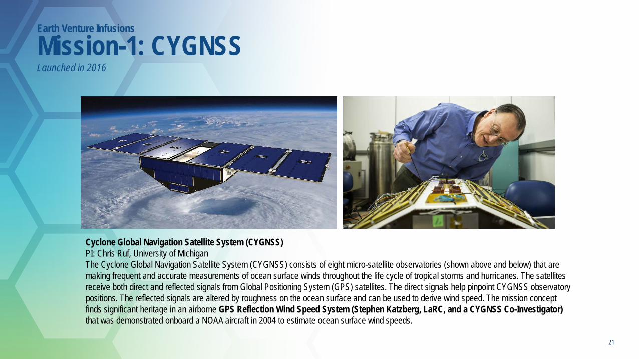
Mission-1: CYGNSSLaunched in 2016
Cyclone Global Navigation Satellite System (CYGNSS)PI: Chris Ruf, University of Michigan The Cyclone Global Navigation Satellite System (CYGNSS) consists of eight micro-satellite observatories (shown above and below) that are making frequent and accurate measurements of ocean surface winds throughout the life cycle of tropical storms and hurricanes. The satellites receive both direct and reflected signals from Global Positioning System (GPS) satellites. The direct signals help pinpoint CYGNSS observatory positions. The reflected signals are altered by roughness on the ocean surface and can be used to derive wind speed. The mission concept finds significant heritage in an airborne GPS Reflection Wind Speed System (Stephen Katzberg, LaRC, and a CYGNSS Co-Investigator) that was demonstrated onboard a NOAA aircraft in 2004 to estimate ocean surface wind speeds.
21

Tropospheric Emissions: Monitoring of Pollution (TEMPO)PI: Kelly Chance, Smithsonian Astrophysical Observatory, Cambridge, MATEMPO, a UV-Vis spectrometer, will provide data on major pollutants in the troposphere. Two ESTO instruments played a pivotal role in developing TEMPO: The Geostationary spectrograph for Earth and Atmospheric Science Applications (GeoSpec - Scott Janz, GSFC), shown below, and the Geostationary Trace Gas and Aerosol Sensor Optimization (GeoTASO - James Leitch, Ball Aerospace). GeoSpec development helped refine the sensor concept necessary for TEMPO, and the GeoTASO algorithm design is guiding TEMPO algorithm requirements. The GeoTASO instrument will also be used as an airborne validation tool for the TEMPO mission.
Earth Venture Infusions
Instrument 1: TEMPOLaunch in 2019
22

ECOsystem Spaceborne Thermal Radiometer Experiment on Space Station (ECOSTRESS) Instrument Delivery 2019 PI: Simon Hook, Jet Propulsion Laboratory (JPL)From the International Space Station, ECOSTRESS will use a high-resolution thermal infrared radiometer to measure plant evapotranspiration, and reveal how ecosystems change with climate. The ECOSTRESS instrument is a direct descendant of the Prototype Thermal Infrared Radiometer for Earth Science (PHyTIR - Simon Hook, JPL), at left.
Global Ecosystem Dynamics Investigation Lidar (GEDI)Instrument Delivery 2019
PI: Ralph Dubayah, University of MarylandFocused on tropical and temperate forests from the vantage point of the International Space
Station, GEDI will use lidar to provide the first global, high-resolution observations of forest vertical structure. GEDI benefits from several ESTO Laser Risk Reduction Program (LRRP),
particularly the work that led to the High Output Maximum Efficiency Resonator (HOMER) Laser (Barry Coyle, GSFC), shown at right, which will be used for the GEDI instrument.
Earth Venture Infusions
Instrument 2: ECOSTRESS & GEDI
23
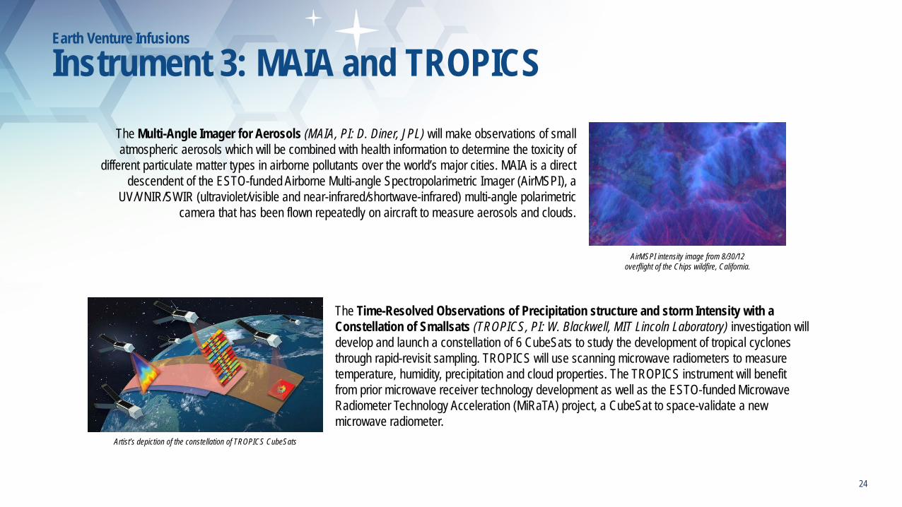
AirMSPI intensity image from 8/30/12 overflight of the Chips wildfire, California.
The Multi-Angle Imager for Aerosols (MAIA, PI: D. Diner, JPL) will make observations of small atmospheric aerosols which will be combined with health information to determine the toxicity of
different particulate matter types in airborne pollutants over the world’s major cities. MAIA is a direct descendent of the ESTO-funded Airborne Multi-angle Spectropolarimetric Imager (AirMSPI), a
UV/VNIR/SWIR (ultraviolet/visible and near-infrared/shortwave-infrared) multi-angle polarimetriccamera that has been flown repeatedly on aircraft to measure aerosols and clouds.
The Time-Resolved Observations of Precipitation structure and storm Intensity with a Constellation of Smallsats (TROPICS, PI: W. Blackwell, MIT Lincoln Laboratory) investigation will develop and launch a constellation of 6 CubeSats to study the development of tropical cyclones through rapid-revisit sampling. TROPICS will use scanning microwave radiometers to measure temperature, humidity, precipitation and cloud properties. The TROPICS instrument will benefit from prior microwave receiver technology development as well as the ESTO-funded Microwave Radiometer Technology Acceleration (MiRaTA) project, a CubeSat to space-validate a new microwave radiometer.
Artist’s depiction of the constellation of TROPICS CubeSats
Earth Venture Infusions
Instrument 3: MAIA and TROPICS
24

Hurricane and Severe Storm Sentinel (HS3)Principal Investigator (PI): Scott Braun, Goddard Space Flight Center (GSFC) HS3 was a five-year airborne mission targeted at understanding the processes that underlie hurricane intensity change in the Atlantic Ocean. Four of the seven instruments carried by the two Global Hawk UAVs for HS3 have ESTO heritage:- High Altitude Monolithic Microwave integrated Circuit (MMIC) Sounding Radiometer (HAMSR), Bjorn Lambrigtsen, Jet Propulsion Laboratory (JPL)- High Altitude Imaging Wind and Rain Airborne Profiler (HIWRAP), Gerry Heymsfield, GSFC- Tropospheric Wind Lidar (TWiLiTE), left, Bruce Gentry, GSFC- An Agile Digital Detector (ADD) for radio frequency interference mitigation used by the Hurricane Imaging Radiometer (HIRAD) instrument, Chris Ruf, University of Michigan
DISCOVER-AQ PI: James Crawford, Langley Research Center (LaRC) - The Deriving Information on Surface Conditions from Column and Vertically Resolved Observations Relevant to Air Quality (DISCOVER-AQ) airborne campaign aimed to improve the interpretation of satellite observations to diagnose near-surface conditions relating to air quality. In 2013, the Geostationary Trace gas and Aerosol Sensor Optimization (GEO-TASO - James Leitch, Ball Aerospace) instrument (at left) joined the campaign to provide aerosol and trace gas measurements.
Airborne Microwave Observatory of Subcanopy and Subsurface (AirMOSS) PI: Mahta Moghaddam, University of Southern CA - The AirMOSScampaign utilized the Uninhabited Aerial Vehicle Synthetic Aperture Radar (UAVSAR - Scott Hensley / Yunling Lou, JPL) instrument, shown below on the NASA Gulfstream III aircraft, to provide high-resolution observations of root-zone soil moisture over regions of North America.
(Three of Five Selected Missions Included ESTO Technology)
Earth Venture Infusions
Suborbital 1: AirMOSS, HS3, and DISCOVER-AQ
25

North Atlantic Aerosols and Marine Ecosystems Study (NAAMES)PI: Michael Behrenfeld, Oregon State University - NAAMES seeks to improve our understanding of how ocean ecosystems might change with ocean warming. NAAMES utilizes the High Spectral Resolution Lidar (HSRL - Johnathan Hair / Chris Hostetler, LaRC) instrument (shown onboard the UC-12 aircraft) to measure the vertical distribution of aerosols within the atmosphere and phytoplankton to three optical depths (~45 m) in the ocean.
ObseRvations of Aerosols above CLouds and their interactions (ORACLES)PI: Jens Redemann, Ames Research Center - the ORACLES campaign, which is investigating how biomass burning in Africa influences cloud cover over the Atlantic, includes the Airborne Second Generation Precipitation Radar (APR-2 - Eastwood Im / Steve Durden, JPL)instrument (Steve Durden with the APR-2 at left) and the Airborne Multiangle SpectroPolarimetric Imager (AirMSPI - David Diner, JPL).
Atmospheric Transport and Carbon-America (ACT-America) PI: Kenneth Davis, Pennsylvania State University - ACT-America is also using the HSRL instrument above as well as the Multi-
Functional Fiber Laser Lidar (MFLL - Michael Dobbs, ITT Excelis) at right to quantify the sources of regional carbon dioxide, methane and other gases, as well as document how weather systems transport these gases in the atmosphere.
(Five of Six Selected Missions Included ESTO Technology)
COral Reef Airborne Laboratory (CORAL)PI: Eric Hochberg, Bermuda Institute of Ocean Science - The CORAL campaign aims to provide critical data and new models to analyze the status of coral reefs and to predict future changes. CORAL is using the Portable Remote Imaging SpectroMeter(PRISM - Pantazis Mouroulis, JPL) instrument (shown) to acquire spectral image data related to reef health.
Oceans Melting Greenland (OMG) PI: Josh Willis, JPL - The OMG campaign is using the Airborne Glacier and Land Ice Surface Topography
Interferometer (GLISTIN-A - Delwyn Moller, Remote Sensing Solutions) instrument to investigate the role of warmer, saltier Atlantic subsurface waters in Greenland glacier melting. (At right: GLISTIN team members with an antenna panel).
Earth Venture Infusions
Suborbital 2: NAAMES, ACT-America, ORACLES, OMG, and CORAL
26

2017 Decadal SurveyTechnologies for New Observations

ESAC 2017 – Implications for ESTO
28
• ESTO is closely involved with ESD planning to translate the recommendations into an executable program over the next 12-18 months
• We have done a preliminary mapping of the targeted observables, and as expected, don’t see many holes
• Decadal has recommended small changes in balance with more resources on technology
• Plans for how to implement the incubation are in formulation, not a big challenge but needs careful consideration – being done in concert with Flight and R&A
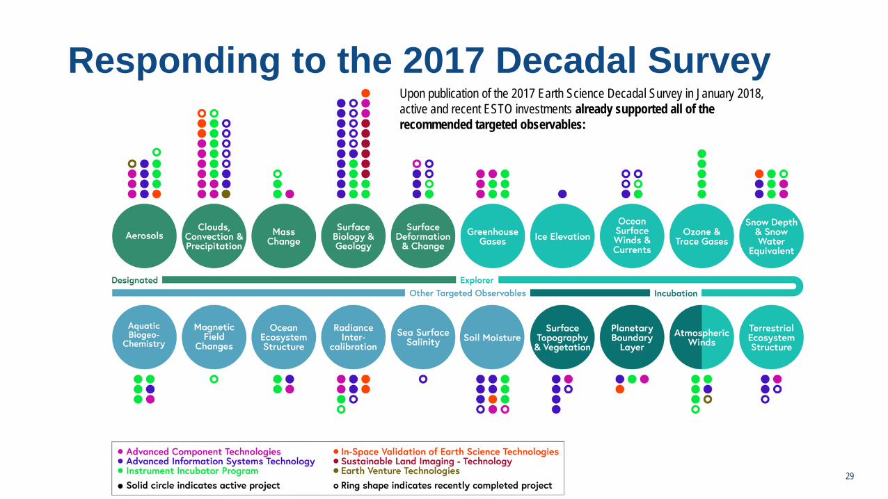
Responding to the 2017 Decadal SurveyUpon publication of the 2017 Earth Science Decadal Survey in January 2018, active and recent ESTO investments already supported all of the recommended targeted observables:
29

Incubation – Atmospheric WindsAward PI / Organization Project
IIP-13 Kevin Maschhoff, BAE Systems
MISTiC Winds: Midwave Infrared Sounding of Temperature and humidity in a Constellation for Winds
IIP-16 Michael Kelly, JHU-APL
Compact Midwave Imaging System
IIP-QRS-16 Michael Kavaya, NASA LaRC
3-D Global Winds: A high pulse rate, lower technology risk coherent wind lidar for airborne science and a global winds pathfinder mission
Directed 2013 Floyd Hovis, Fibertek
High Power UV Laser Lifetime Demonstrator
IIP-13 Sara Tucker,Ball Aerospace
HSRL for Aerosols, Winds, and Clouds using Optical Autocovariance Wind Lidar (HAWC-OAWL)
EVI-14 R. Michael Hardesty, University of CO
Green OAWL Airborne Demonstrator / ATHENA-OAWL: Atmospheric Transport, Hurricanes and ExtratropicalNumerical Weather Prediction with OAWL
AIST-16 Charlie Zender, University of California, Irvine
JAWS: Justified AWS-like data through workflow enhancements that ease access and add scientific value
30

Incubation – Planetary Boundary LayerAward PI / Organization Project
ACT-17 Bill Deal, NGC
Integrated Receiver and Switch Technology (IRaST)
AIST-16 Anne Wilson, University of Colorado, Boulder
HY-LaTiS: Evolving the functional data model through creation of a tool set for hyperspectral image analysis
INV-15 Thomas Pagano, JPL
CubeSat Infrared Atmospheric Sounder (CIRAS)
IIP-16 Matthew Lebsock, JPL
Development and Demonstration of an Airborne Differential Absorption Radar for Humidity Sounding Inside Clouds
HY-LaTiS architecture31

Incubation – Surface Topo & VegetationAward PI / Organization Project
AIST-14 Matthew French, USC/ISI
A Hybrid Multi-core CPU/FPGA/DSP Flight Architecture for Next Generation Earth Science Missions
AIST-16 Matthew French, USC/ISI
SpaceCubeX: On-board processing for Distributed Measurement and Multi-Satellite Missions
AIST-16 Christopher Neigh, NASA/GSFC
Automated protocols for generating very high-resolution commercial validation products with NASA HEC resources
AIST-16 Andy Michaelis, California State University
Framework for Mining and Analysis of Petabyte-size Time-series on the NASA Earth Exchange (NEX)
AIST-16 Anne Wilson, University of Colorado, Boulder
HY-LaTiS: Evolving the functional data model through creation of a tool set for hyperspectral image analysis
ATI-17 Xiaoli Sun, NASA GSFC Evaluating Selex HgCdTe Detectors for Space Lidar
32

CSIM, developed through a grant awarded in 2013, is an ultra-compact, solar spectral irradiance (SSI) monitor covering 200-2400 nm with the required SI-traceable accuracy and on-orbit stability to meet solar input measurement requirements for establishing benchmark climate records. The instrument design and layout marks a significant departure from the previous SIM instruments, achieving large reductions in mass, volume, and power requirements, and enabling a flight-qualified instrument in a 6U CubeSat package. With follow-on funding, this project will finalize and launch CSIM (NET September 2018) to demonstrate its performance in meeting the SSI measurements being made by the SORCE SIM and planned for the TSIS SIM (launches in early 2018). With one year of planned operations, the project team hopes to demonstrate a viable 6U CubeSat SSI instrument that could maintain the SSI climate data record, compare calibration and measurements against SORCE and TSIM, and raise the TRL of several new technologies that could be applicable to other instruments and missions.
Principal Investigator: Erik Richard, LASP
SORCE SIM (launched 2003)- 2-channel instrument - 1st generation absolute ESR detector (NiP bolometer)- Accuracy: 2-10% wavelength dependent (no SI validation)
TSIS SIM (2018 planned launch)- 3-channel instrument - 2nd generation absolute ESR detector (NiP bolometer)- Accuracy: 0.2% (SI-traceable validation)
CSIM (2018 planned launch)- 2-channel instrument - 3rd generation absolute ESR detector with best noise performance to date - Accuracy: 0.2% (SI-traceable validation)
Compact Spectral Irradiance Monitor (CSIM) Flight Follow-On
33Innovation to enable sustained observations in a more cost-effective way

• A multispectral (UV-VIS-NIR) solar occultation imager imager capable of SAGE-quality ozone and aerosol measurements
• Instrument and spacecraft fit inside a 6U form factor• Enables sustainability and a constellation for better coverage
• SAGE IV relevance to 2018 Decadal Survey Report:• Aerosols and ozone are designated as observing system priorities• SAGE IV meets definition of newly-recommended Venture-continuity
missions by “bringing forward innovative approaches to sustain measurements at lower costs”
Principal Investigator: Robert Damadeo, NASA LaRC
SAGE IV Pathfinder IIP-16 Stratospheric Aerosol and Gas Experiment IV
SAGE IV Observational Concept
SAGE IV 6U Spacecraft Design
34Innovation to enable sustained observations in a more cost-effective way

Emerging TechnologiesAdvanced Sensors and Information Systems Technologies

Spectrometer using Free-form Optics• Advancements in manufacturing techniques have enabled free-form optics – optics that lack translational or rotational
symmetry on at least one surface• The use of free-form optics can enable high spectral and spatial resolution on a very small spacecraft bus• In some cases, they can also provide better overall imaging performance for high aspect ratio applications• Compact and lightweight packaging
PI: John Ranson, NASA GSFC 36
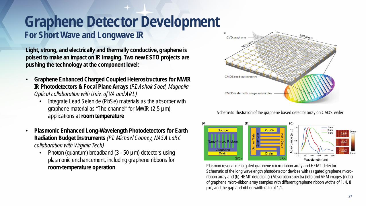
Graphene Detector Development For Short Wave and Longwave IRLight, strong, and electrically and thermally conductive, graphene is poised to make an impact on IR imaging. Two new ESTO projects are pushing the technology at the component level:
• Graphene Enhanced Charged Coupled Heterostructures for MWIR IR Photodetectors & Focal Plane Arrays (PI: Ashok Sood, Magnolia Optical collaboration with Univ. of VA and ARL)
• Integrate Lead Selenide (PbSe) materials as the absorber with graphene material as “The channel” for MWIR (2-5 µm) applications at room temperature
• Plasmonic Enhanced Long-Wavelength Photodetectors for Earth Radiation Budget Instruments (PI: Michael Cooney, NASA LaRCcollaboration with Virginia Tech)
• Photon (quantum) broadband (3 - 50 µm) detectors using plasmonic enchancement, including graphene ribbons for room-temperature operation Plasmon resonance in gated graphene micro-ribbon array and HEMT detector.
Schematic of the long wavelength photodetector devices with (a) gated graphene micro-ribbon array and (b) HEMT detector. (c) Absorption spectra (left) and AFM images (right) of graphene micro-ribbon array samples with different graphene ribbon widths of 1, 4, 8 µm, and the gap-and-ribbon width ratio of 1:1.
Schematic illustration of the graphene based detector array on CMOS wafer
37

Integrated Micro-Photonics for Remote Earth Science Sensing Lidar
Existing Technology ACT-17 Funded Work
Photonic Integrated Circuits (PICs) will enable more frequent and lower cost missions for remote Earth science sensing from small craft and small satellite platforms.
Collaboration between Univ. of California, Santa Barbara and NASA GSFC 38

Metasurface/Metamaterial Technologies
Shared aperture MetasurfaceAntenna with dual beam pattern
Metamaterial Spectrometer (MS)• While the MS technology reduces the demands on several
subsystems through its selectable spectral channels, the most dramatic effect is the elimination of the spectrometer subsystem itself.
• Greatly reduces the size and mass of the spectral instrument and eliminates the most thermally-sensitive subsystem.
Metasurface Antenna• Capable of beam shaping, and pointing, a simple on-surface control pf
the aperture fields in a low profile• Can be readily fabricated using lithography and nanoprinting methods,
and the ultrathin thickness in the wave propagation• Does not require the deployment of a feed, unlike reflectarrays and
mesh reflectors; its planar design provides expandability in size for small spacecraft such as CubeSats/SmallSats.
39

Phenomena measured from all vantage points –In situ, airborne and on-orbit platformsLeverage New Technological Opportunities to reduce cost of NASA investments
- Emergence of smallsats - Commercial and international space platforms- Modern data analysis, including Machine Learning and other Artificial Intelligence
Design an Observing System rather than an individual mission- Envelope: commercial and international, in situ and airborne platforms, models- Resulting NASA Mission makes only the unique measurements that need to be made from space
Observing System- An approach to characterizing a natural phenomenon or physical process using all the data available to understand it. This feeds into one
or more forecast models which support prediction of the evolution and behavior of this physical process.Incorporate a high degree of autonomy and automation
- Reduce cost of operations- Enable Observing System to react quickly to evolving events
AIST Projects- Sensor Web Competed Research Projects (AIST99, AIST05, AISTQRS-06, AIST08, AIST11, AIST14, AIST16) - AIST New Observing Strategy Workshop May 15-16, 2018
40

Estimating the Science Value• Valuation of the Observations enabling a comparison among alternative Observing Systems
- Identify the measurements from space which are the most important to make - Transient and transitional events make some measurements sometimes more important than others- Following Quality definition from NAS Study on Continuity
- Key characteristics suitable for discrimination among measurements- Method for evaluating measurement characteristics- Method for rating a measurement based on characteristics
- Following Benefit Characteristic from NAS Study on Continuity- Scientific Importance: I to the science community- Utility: U to a specified quantified scientific objective- Quality: Q - Success Probability: S, including use of commercial and international partners
- Affordability: cost analysis, including risk• AIST Projects
- NASA Earth Observing Systems Simulation, Tanelli (JPL) (AIST11-0020)- Land Information System OSSE for SMAP and GRACE Follow-on, Peters-Lidard (GSFC) (AIST11-0013)- MISTiC Wind OSSE (With Jack Kaye, Tsengdar Lee, David Considine), McCarty(Goddard Modeling and Assimilation Office) (STUDY16-0004)- Mission Planning Tool for Sensing of Snow (With Jared Entin), Forman, (UMD) (AIST16-0024) - Multi-platform mission planning and operations simulation for adaptive remote sensors, Johnson (Ohio State University) (AIST16-0060)
41

Designing an Observing System to Unify Results• Key Questions for Distributed Spacecraft Mission Design:
- How many Satellites to obtain coverage sufficient to provide science value?- Life Cycle Cost, reliability, launch cost/opportunities, - What happens when there is a node failure?- What other sources of observations are available?- Which measurements need to be made from space?- Which measurements are better from in situ or airborne platforms?
• Integrating different platforms into a single, coherent data product- Intercalibration among instruments is essential to a unified data product
• AIST Projects- Tradespace Analysis Tool for Design of Distributed Missions (TAT-C)
- GSFC (LeMoigne-Stewart) (AIST14-0053)- Multi-platform mission planning and operations simulation for adaptive remote sensors
- Ohio State University (Johnson) (AIST16-0060)
42

Management of the Observing SystemCurrent approach to Mission Operations cannot scale or react quickly
• Lack of interconnectedness impedes integration of measurements• Cannot take advantage of steerable instruments or platform retasking• Labor intensive manual processes increases cost and reaction time to events• Will be difficult to respond to traffic control of Low Earth Orbit• Commercial space and USAF are already leveraging technology to reduce cost
Need autonomy and integration• Must improve Computer Security• Enable Goal Directed Autonomy to react to detected phenomenon and reconfigure assets in real time• Requires dynamic intercalibration• Enable coupling among sensors and models
AIST Projects• AIST New Observing Strategy Workshop (Cole) May 15-16, 2018• SMD Autonomy Workshop, September, 2018• High Performance Spaceflight Computer (with STMD and USAF) (Doyle) AIST-QRS16-0006• Spacecube-X simulator/emulator for onboard processing (French)(USC/ISI) AIST14-0049, AIST16-0031• Onboard dynamic recalibration of NextGen UAV Spectral Systems (Campbell) AIST14-0090• Block-chain concept paper (Dwan) AIST-QRS17-0002• Model Predictive Control Architecture for Optimizing Earth Science Data Collection (Lieber) (Ball Aerospace), AIST14-0110• Fellowship on Theoretical Underpinnings of intercalibration among nodes of a Constellation (TBD)
43

High Volume Science Data ProcessingLarge volumes of data from multiple platforms at different vantage points
• Some data may also come from commercial or non-NASA sources, such as NOAA, USGS, EPA, ESA • Requires Intercalibration among elements of the observing System• Careful uncertainty quantification through the observation and processing stages
AIST Projects• ARIA SAR Science Data Processing Foundry including Cloud Computing
- Rosen, Hua (AIST11-0022, AIST11-0030, AIST14-0109, AIST16-0016)• AIST Managed Cloud Environment, Cole and Duffy (GSFC)
Commercial firms and ESA are using very modern, fast processing workflows to produce products within hours of observations
44

Summary
45
• The Earth Science Technology Program inherently enables the implementation of the decadal surveys
• Continuous pursuit of miniaturization and reducing SWaP translates to:- improving affordability and sometimes simplification- enabling implementation options, such as constellations, that can improve spatial coverage and temporal frequency
• Already investing in Incubation and Continuity areas
• The successful infusion of technologies into Earth Venture program line is expected to expand to the Venture Continuity strand
• Investments to advance components, sensors and information technology will yield affordable observations
• We are looking forward to working closely with R&A and Flight on the implementation of the Incubation line

Upcoming Events
2018 Earth Science Technology Forum
June 12-14 – Silver Spring, MD• Approximately 60 presentations from tech projects• Michael Freilich to give a plenary on Tuesday afternoon (6/12)• Second day, Wednesday 6/13, to include Emerging Tech panel• More at: esto.nasa.gov
AIST New Observing Strategies Workshop
May 15-16 – Washington, DCWorkshop Goal: Advance agile and intelligent constellations that are better equipped to sense and react to science anomalies, to act and react to triggers from models or sensor webs, and to interact among themselves to best achieve their intended commands.
46

Thank you! Questions?