technology options and interoperability for urban … 6 - technology interop draft_for... · mmmll...
TRANSCRIPT
mmmll
Technology options and
interoperability for Urban
Vehicle Access Regulation
(UVAR) Schemes
Non-binding guidance documents
on UVAR schemes N° 6/6
DRAFT
Preparation of EU guidance on Urban Vehicle Access Regulations Contract No. MOVE/C1/SER/2014-371
September 2016 I 2
This draft of non-binding Document is part of a stakeholders consultation process
within the scope of a European Commission (Directorate General for Mobility and
Transport) commissioned study. The consortium responsible for this study is formed
by ISIS and PwC. The document does not express the views of the Commission.
Preparation of EU guidance on Urban Vehicle Access Regulations Contract No. MOVE/C1/SER/2014-371
September 2016 I 3
Table of Contents
Table of Contents ................................................................................. 2 Glossary ............................................................................................... 4 CHAPTER I – Introduction ................................................................... 5 CHAPTER II – The challenges .............................................................. 6
Overview of technological options ..................................................................... 7 Trading off the technological options' characteristics ........................................... 9 Future technological options ............................................................................11
Chapter III - Available options .......................................................... 12 ANPR-based technologies ................................................................................12
London ......................................................................................................12 Milan .........................................................................................................14 Stockholm ..................................................................................................15
DSRC-based technologies ...............................................................................16 Oslo ..........................................................................................................16 Lessons learned from the available options ....................................................17
CHAPTER IV – Potential impacts of a common European approach on technology and interoperability ......................................................... 20 CHAPTER V – Barriers and enablers to a common approach .............. 22
Barriers at local and EU level ...........................................................................22 Enablers at local and EU level ..........................................................................23
VI Recommendations ......................................................................... 25
Preparation of EU guidance on Urban Vehicle Access Regulations Contract No. MOVE/C1/SER/2014-371
September 2016 I 4
Glossary
ANPR Automatic Number Plate Recognition
ASECAP Association Européenne des Concessionnaires d'Autoroutes
CEN Comité Européen de Normalisation
DSRC Dedicated Short Range Communication
EC European Commission
EETS European Electronic Toll Service
EFC Electronic Fee Collection
ETC Electronic Toll Collection
ETSI European Telecommunications Standards Institute
EU European Union
GIS Geographical Information System
GLONASS Globalnaya Navigatsionnaya Sputnikovaya Sistema=RUS version of GPS
GNSS Global Navigation Satellite System
GPRS General Packet Radio Service
GPS Global Positioning System
GSM Global System for Mobile
ICT Information and Communication Technologies
ISO International Organisation for Standardization
ITS Intelligent Transport Systems
OBU On-Board Unit
OCR Optical Character Recognition
RFID Radio Frequency Identification
UVAR Urban Vehicle Access Regulation
V2I Vehicle to Infrastructure
V2V Vehicle to Vehicle
ZTL Zona a Traffico Limitato (Limited Traffic Zone)
Preparation of EU guidance on Urban Vehicle Access Regulations Contract No. MOVE/C1/SER/2014-371
September 2016 I 5
CHAPTER I – Introduction
This NBGD on ‘Technology options and interoperability’ is meant to provide an
overview of technological options and their interoperability. This concerns both current
options and such likely to be developed in the near future with reference to the
implementation of UVAR schemes in Europe. Interoperability may have a technological
as well as a geographical dimension. The technological interoperability of a specific
option addresses the capability of the technological options to adapt to different
scheme design and characteristics For example in terms of vehicle type detection,
payment methods, period of operation, e.g. night or selected day time slot and
enlargement of a UVAR area. The geographical interoperability deals with the
capability of the technological options to operate at different scales (urban, regional,
national, European). In general, the implementation of UVAR schemes is more
concerned with the technological interoperability given the local scale of UVAR
schemes. However, reaching geographical interoperability may reduce implementation
costs and facilitate the movement across borders as well as contribute to completing ,
the Single Market in the area of transport.
The range of technological options supporting UVAR implementation schemes has
broadened considerably in recent years, for instance by the development of global
positioning systems and mobile technologies. It is reasonable to expect that this trend
will continue. Technological options unveil new opportunities in terms of easing
operating characteristics e.g. by the facilitation of methods of payment and the
enlargement of geographical coverage.
However, despite the greater opportunities from technological development the
selection of the most appropriate technology still relies on trading-off a considerable
number of factors.
They range from the extent and types of roads to be covered, the types and numbers
of road users to be charged or enforced and the augmented capability in terms of data
collection to emergent privacy issues. The most sophisticated technological solutions
can maximise compliance, guarantee thereby an acceptable stream of revenues to pay
back investment where charges are applied and can be implemented with low costs of
ownership and maintenance.
The main objective of this NBGD is therefore to review the relevant aspects involved in
the selection of the technological solutions while supporting the different options with
concrete examples on available options.
Preparation of EU guidance on Urban Vehicle Access Regulations Contract No. MOVE/C1/SER/2014-371
September 2016 I 6
CHAPTER II – The challenges
As discussed in the NBGD on Vehicle Types, Exemptions and (Cross-border)
Enforcementi, the role of technology applications adopted in the implementation of the
different types of UVAR schemes is strongly correlated with the type of UVAR schemes
under examination.
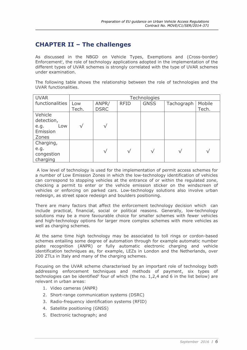
The following table shows the relationship between the role of technologies and the
UVAR functionalities.
UVAR functionalities
Technologies
Low
Tech.
ANPR/
DSRC
RFID GNSS Tachograph Mobile
Tech.
Vehicle detection,
e.g. Low Emission
Zones
√ √
Charging,
e.g. congestion charging
√ √ √ √ √
A low level of technology is used for the implementation of permit access schemes for
a number of Low Emission Zones in which the low-technology identification of vehicles
can correspond to stopping vehicles at the entrance of or within the regulated zone,
checking a permit to enter or the vehicle emission sticker on the windscreen of
vehicles or enforcing on parked cars. Low-technology solutions also involve urban
redesign, as street space redesign and boulders positioning.
There are many factors that affect the enforcement technology decision which can
include practical, financial, social or political reasons. Generally, low-technology
solutions may be a more favourable choice for smaller schemes with fewer vehicles
and high-technology options for larger more complex schemes with more vehicles as
well as charging schemes.
At the same time high technology may be associated to toll rings or cordon-based
schemes entailing some degree of automation through for example automatic number
plate recognition (ANPR) or fully automatic electronic charging and vehicle
identification techniques as, for example, LEZs in London and the Netherlands, over
200 ZTLs in Italy and many of the charging schemes.
Focusing on the UVAR scheme characterised by an important role of technology both
addressing enforcement techniques and methods of payment, six types of
technologies can be identifiedii four of which (the no. 1,2,4 and 6 in the list below) are
relevant in urban areas:
1. Video cameras (ANPR)
2. Short-range communication systems (DSRC)
3. Radio-frequency identification systems (RFID)
4. Satellite positioning (GNSS)
5. Electronic tachograph; and
Preparation of EU guidance on Urban Vehicle Access Regulations Contract No. MOVE/C1/SER/2014-371
September 2016 I 7
6. Mobile communications (GSM and smartphones).
Overview of technological options
1.Video cameras or ANPR (Automatic Number Plate Recognition) are widespread
technologies utilizing fiber optic or broadband to convey information from roadside
cameras to a hub site where information is processed. It does not require on-board
units (OBUs) and costly roadside equipment. In terms of enforcement, a strong limit is
the lack of harmonisation of vehicle license plates which can make the identification of
the vehicle problematic (also in presence of adverse weather conditions). This
technology requires foreign vehicles to be registered before approaching the scheme
area due to national vehicle database issues. Data protection and legal issues may
arise from the application of the technology depending on the Member State. For
example in Germany the picture needs to capture who is driving, while in the
Netherlands the driver may not be identifiediii.It should also be considered that for
ANPR manufacturing there are no CEN standards to date.
Example: Applications in cordon-based or area-based UVAR schemes: e.g.
London, Milan, Stockholm.
2..DSRC (Dedicated Short-Range Communication) can be considered the most widely
adopted technology in Europe, in particular as far as electronic payments are
concerned in both urban areas and nationwide networks. The technology is based on
radio communication between a mobile device inside the vehicle (OBU) and fixed
roadside equipment. The OBU microwave technology (DSRC 5.8 Ghz) allows levying
the tolls electronically as soon as the vehicle approaches the fixed roadside equipment
without stopping it. It is important to stress that the technology benefits from
standardization (CEN standard 15509), geographical interoperability (on some
European motorways networks) and, to a minor extent, technical interoperability
(some OBUs can also be used to pay for parking in certain environments). DSRC
technologies use in general inexpensive OBUs (ranging from €5 to €10) but they
require the installation of costly roadside equipment. In urban areas, the most
appropriate technological version of DSRC applications is the one defined as multi-lane
free flow (MLFF) in which vehicles do not need to slow down to pay the toll. The
association of DSRC with ANPR technologies for enforcement has become a common
standard. The technology is generally not perceived as raising privacy issues despite
the fact that users must save personal data stored in the OBU.
Example: Applications in urban areas such as Singapore, Stockholm, Göteborg
Santiago del Chile, Melbourne, Florence and the Norwegian cities (e.g. Oslo,
Trondheim)
3..RFID (Radio-frequency) represents a technological option with similar performance
levels to DSRC. This technology uses generally ANPR technologies for enforcement as
DSRC technologies. Compared to the DSRC technologies, its main advantage is the
lower cost of OBUs (~€1). The main geographical area of application is the US, with
no significant applications in Europe (except for the access point regulation in the
Mersey Tunnels and Gateway Bridge in the UK). One of the reasons behind the slow
deployment of the technology in Europe is the significant investment required to
replace existing technologies.
Example: Applications on US motorways (e.g. North Carolina)
4..GNSS (Global Navigation Satellite System) technology requires the interplay of
three components:
1) A GNSS OBU module which is the infrastructure that allows users with a compatible
device to determine their position, velocity and local time by processing signals
from satellites in space
Preparation of EU guidance on Urban Vehicle Access Regulations Contract No. MOVE/C1/SER/2014-371
September 2016 I 8
2) A GSM module securing GPRS data communication from the OBU to the back office
and vice versa; and optionally
3) A microwave module (DSRC transceiver) to communicate with fixed and mobile
enforcement points, e.g. control gantries provided with DSRC and/or ANPR
technologies.
From an economic point of view, this option requires cheaper roadside equipment than
DSRC/ANPR options but costs of the GNSS OBU module are higher than DSRC OBU
units in the order of magnitude of a factor ten. However, in the long run, GNSS-based
options may prove cost-effective: common standards for GNSS OBUs may reduce
costs due to a possible integration with car manufacturers and the higher flexibility of
the application (e.g. through maps updating) can change the UVAR's conditions
(position, time, period of day) at virtually no cost.
Furthermore, interoperability of GNSS-based systems has proven to be effective both
geographically and with reference to existing DSRC applications.
Data privacy may be an issue because of the relevant amount of information collected
with the possibility to create movement profiles.
Concerning the urban areas in Europe, there are promising signalsiv from the potential
use of the current improved performance in urban canyons of Galileo (the European
GNSS). Several ongoing trials (e.g. in the Greater Copenhagen area) and in the past
(Eindhovenv) show promising results. On the other hand, in the London trials carried
out between 2004 and 2007 the scale and density of tall buildings and the
configuration of relatively narrow streets, particularly in the City of London, prevented
the level of precision location of vehiclesvi. Singapore is planning to shift the DSRC-
based technology to the new Global Navigation Satellite System (GNSS)-based ERP
system, which will be operational from 2020vii. The urban road operator interest in
such a system, using also the first EGNOS services, lies in the possibility to distinguish
areas where different rules/ pricing schemes are applied, i.e. to select roads in dense
urban areas inside/ outside the UVAR area. Other interesting features are the real-
time monitoring of vehicle itineraries and stops according to permits and the reliable
positioning of urban regulated fleets.
Example: From 1 January 2014, Slovakia’s Skytoll system added additional 1st, 2nd
and 3rd class roads (urban roads) to the GNSS-based charged network, expanding
the total chargeable road network for heavy goods vehicles.
In the period from October 2010 to July 2011, the EGNOS2road (E2R) projectviii
assessed the added value/ economic benefits of EGNOS with respect to the GPS for
the road sector, specifically for two applications: road tolling and tracking & tracing
of professional fleets. EGNOS is operational and provides three services over Europe
augmenting the GPS position in terms of enhanced accuracy and integrity
information: EGNOS Open Service (EGNOS OS) and EGNOS Safety Of Life (EGNOS
SoL) broadcasted via the satellites’ signal, and EGNOS Commercial Service (EGNOS
CS) distributed to professional users through terrestrial networks via a server
named EDAS. E2R key findings are that EGNOS OS generally enhances the position
measured using GPS only in all extra-urban and urban environments. The two
operators involved in E2R, SAT (Italian motorway) and RSM (Rome Mobility Agency)
evaluated the added value of EGNOS with respect to GPS standalone, and concluded
that the benefits rely on enabling a more robust and reliable positioning.
5..Tachograph-based technology is based on an OBU connected to the vehicle
odometer. The technology does not raise privacy issues and limits the roadside
equipment needed to border crossings apart of the use of ANPR technologies for
enforcement. On the other hand, the OBU is expensive. Since the first national
application in Switzerland (2001), a certain degree of partial interoperabilityix has been
reached in accordance with the CEN DSRC 5.8 GHz standards successfully
Preparation of EU guidance on Urban Vehicle Access Regulations Contract No. MOVE/C1/SER/2014-371
September 2016 I 9
implemented in Austria. However, the technology is applied on heavy goods vehicles
only and it is of limited relevance in urban areas.
Example: Application on the Swiss road network
6.. Mobile communication (GSM and smartphones) is a promising technological
option, supported by a continuing technological development even if the current
applications in urban areas are actually limited to the trial or pilot stages. In
combination with ANPR, DSRC, RFID and GNSS technologies, the mobile
communication technologies play an important role as far as payment mechanisms are
concerned. For example, according to the C2S trial in Portugal, the OBU integrated
with the smartphones through a mobile application pays the toll and the enforcement
role is played by ANPR technologies. In general, mobile communication technologies
allow the user to pay the toll being more interoperable (due to the smartphone
technologies) and transparent (the user can see the tolls and charges in real time).
Since recently, it is possible to pay the access fee to the UVAR Milan Area C via
smartphone x.
Having said that, the technology is not mature yet and various issues still need to be
addressed such as the rapid technological obsolescence of some standards. For
example, current systems based on GSM solutions could become obsolete in the near
futurexi.
It is worthwhile to note that the EC Directive on the interoperability of electronic road
toll systemsxii in the Community has indicated DSRC, GNSS and GSM/GPRS as the only
suitable technologies. However, the Directive was not applicable to small, strictly local
road toll systems and its implementation has mainly concerned the tolled interurban
road network.
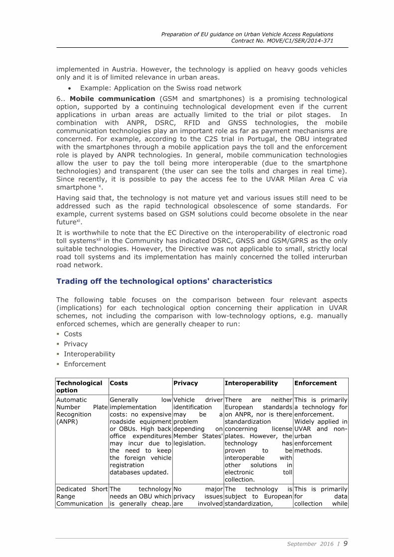
Trading off the technological options' characteristics
The following table focuses on the comparison between four relevant aspects
(implications) for each technological option concerning their application in UVAR
schemes, not including the comparison with low-technology options, e.g. manually
enforced schemes, which are generally cheaper to run:
Costs
Privacy
Interoperability
Enforcement
Technological option
Costs Privacy Interoperability Enforcement
Automatic
Number Plate Recognition (ANPR)
Generally low
implementation costs: no expensive roadside equipment or OBUs. High back office expenditures may incur due to
the need to keep
the foreign vehicle registration databases updated.
Vehicle driver
identification may be a problem depending on Member States' legislation.
There are neither
European standards on ANPR, nor is there standardization concerning license plates. However, the technology has
proven to be
interoperable with other solutions in electronic toll collection.
This is primarily
a technology for enforcement. Widely applied in UVAR and non- urban enforcement
methods.
Dedicated Short
Range Communication
The technology
needs an OBU which is generally cheap.
No major
privacy issues are involved
The technology is
subject to European standardization,
This is primarily
for data collection while

Preparation of EU guidance on Urban Vehicle Access Regulations Contract No. MOVE/C1/SER/2014-371
September 2016 I 10
Technological option
Costs Privacy Interoperability Enforcement
(DSRC) However, roadside equipment
(gantries) for tolling and enforcement are costly in particular where a dense network of equipment is necessary.
given that the position of the
vehicle is not monitored. Personal information may however be needed to fill in the OBU.
notably CEN rules make the technology
interoperable (e.g. for parking and tunnels).
DSRC technologies are
also used for enforcement in the form of mobile enforcement units equipped with DSRC.
RFID (Radio-frequency)
The costs are similar to the DSRC technology except for the cheaper OBU.
No privacy issues raised.
In the US, where the technology is mainly implemented, geographical interoperability has been reached.
This is primarily for data collection while ANPR is still used for enforcement.
Global Positioning System (GPS)/ Global Navigation
Satellite Systems (GNSS)
Implementation costs and back office work for maintenance and map updates make
the technological solution expensive
since the OBU price is higher than in the DSRC solution.
Data protection may be an issue due to the significant required
amount of information
collected from the users.
The technology is interoperable as the examples of the German and Austrian GPS-based systems
show.
Roadside equipment, e.g. gantries or camera required for enforcement
Maybe
operational problems with urban canyons and nearby routes.
Tachograph Despite of part of the maintenance cost being born by the user, the
implementation costs are high (OBUs and roadside
equipment).
No data protection and privacy issues.
Some interoperability with border countries has been realized.
Enforcement gantries are needed.
Mobile communication
The applications require lower
investment in road side systems while no OBUs are required.
Data protection may be an
issue. Potentially, relevant personal information may be collected.
Interoperability of smart phone
applications is high but technological obsolescence of standards may be an issue.
The enforcement in smart phone-
based systems is similar to that of DSRC or GNSS-based systems. DSRC and ANPR technologies are
needed.
The table shows that the final choice of technology for any scheme which aims to be
cost-effective in the long term has to be made after trading off a certain number of
factors.
In urban areas, Automatic Number Plate Recognition (ANPR) has been in service for
many years. In everyday operation, it offers convenience of use and robustness, does
not require OBUs and has proven to be interoperable. The cost to run such systems
relative to other high-technology options is typically low and the technology is well
understood by road operators.
Preparation of EU guidance on Urban Vehicle Access Regulations Contract No. MOVE/C1/SER/2014-371
September 2016 I 11
Schemes combining Dedicated Short Range Communication (DSRC) with ANPR
technologies for enforcement, particularly in motorways, e.g. TELEPASS, have been
implemented in several tolling motorways as well as deployed on strategic routes in a
certain number of European member states. However, in urban areas, the need of
monitoring gantries and the corresponding lack of physical barriers makes the DSRC
implementation not particularly widespread (apart from Singapore and Norwegian
cities and some case in Italy, e.g. the Milan Area C.).
GPS/GNSS solutions in urban areas must face several barriers: Firstly, additional
roadside equipment need to be installed to improve signals where they are weak (e.g.
in urban canyons), augmenting investment costs. Furthermore, compared to the DSRC
equipment, which have the advantage of being cheap to procure and easy to use, the
OBUs required for GPS/GNSS-based schemes are expensive. Another important
barrier is enforcement since in order to avoid additional investments for gantries, the
risk of high non- compliance rates is high.
From the point of view of the cost-efficiency of the technological solutions, mobile
communications systems from trials and research projects may be a promising option:
flexibility to define and modify what and how is to be charged , no significant physical
tolling roadside or infrastructure investment needed, no need for OBUs or costly
enforcement infrastructure. However, uncertain accuracy in detecting vehicles in the
urban context or in certain sections of the network and more importantly the inability
to classify vehicles make their use in urban areas problematic, at least in the near
future. Furthermore, a mobile method's disadvantage is that it requires a smart phone
which discriminates against persons who do not use this appliances.
Future technological options
Other technological developments may in the future support the implementation of
UVAR schemes even if a sufficient number of trials and pilots are not available to draw
preliminary conclusions. Among them, it is worthwhile to mention the followingxiii:
In-vehicle Intelligent Transport Systems (ITS) technology, for example within the
Cooperative Vehicle Information Systems (CVIS) and Communications Access for
Land Mobiles (CALM) areas. Connected Driving (or C-ITS) technologies, which allow
vehicles to become connected to each other, and to the infrastructure and other
parts of the transport network. These technologies can in the future provide
technological functionalities favouring billing fines, vehicle identification and
positioning.
In-vehicle applications such as telematics for vehicle and driver management, eCall,
usage-based insurance (UBI) and different types of Event Data Recorders (EDRs)
Low cost combined GNSS/accelerometer devices to track movements even where
satellite visibility may be poor;
Mapping standards, map quality, highway section asset management and algorithms
for determining when a vehicle has passed a “virtual tolling point” or similar “toid”
(Topographic Identifier); and
Cloud-based storage and processing which reduces operating costs and improves
the speed of calculation of the distance driven, the toll due and the cleaning of
erroneous data.
Preparation of EU guidance on Urban Vehicle Access Regulations Contract No. MOVE/C1/SER/2014-371
September 2016 I 12
Chapter III - Available options
This chapter focuses on the illustration of examples of technological options
implemented in European UVAR schemes. Despite the fact that technological options
usually work in combination, the available options described in this chapter have been
identified according to the prevailing operating technology in order to flag examples of
technological solutions representative of specific types of technologies. Namely, two
types of technological solutions have been identified:
Automatic Number Plate Recognition (ANPR)-based technologies as used in London,
Stockholm and Milan;
Dedicated Short Range Communication (DSRC)-based technologies as used in
Norwegian cities, e.g. Oslo.
The following boxes describe for each urban area the technological characteristics of
the UVAR schemes while the final section focuses on lessons learned.
ANPR-based technologies
London
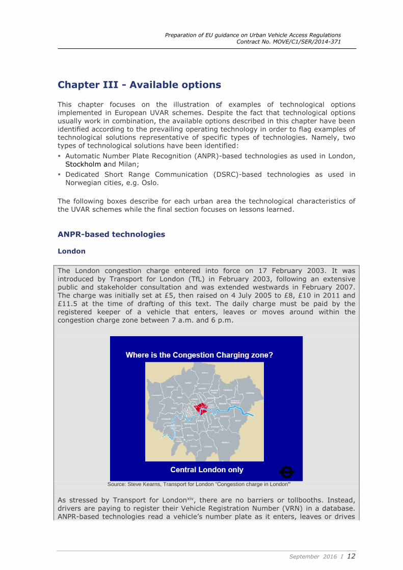
The London congestion charge entered into force on 17 February 2003. It was
introduced by Transport for London (TfL) in February 2003, following an extensive
public and stakeholder consultation and was extended westwards in February 2007.
The charge was initially set at £5, then raised on 4 July 2005 to £8, £10 in 2011 and
£11.5 at the time of drafting of this text. The daily charge must be paid by the
registered keeper of a vehicle that enters, leaves or moves around within the
congestion charge zone between 7 a.m. and 6 p.m.
Source: Steve Kearns, Transport for London “Congestion charge in London”
As stressed by Transport for Londonxiv, there are no barriers or tollbooths. Instead,
drivers are paying to register their Vehicle Registration Number (VRN) in a database.
ANPR-based technologies read a vehicle’s number plate as it enters, leaves or drives
Preparation of EU guidance on Urban Vehicle Access Regulations Contract No. MOVE/C1/SER/2014-371
September 2016 I 13
within the charging zone and check it against the database of those who have paid the
charge or those who do not have to pay (because they are exempt or registered for a
100 per cent discount). Once a VRN has been matched, the photographic images of
the vehicle are automatically deleted from the database.
The daily charge can be paid before or on the day of travel, by telephone, text
message, online and by post. Drivers have up to midnight on the day of travel to pay
the £11.50 charge or £14.00 if they pay the next charging day after travelling in the
zone.
The charge can also be paid via Congestion Charging Auto Pay which is an automated
payment system that has a discounted daily charge rate of £10.50. Drivers need to
register with TfL to pay via Auto Pay and it will automatically record the number of
charging days a vehicle travels within the charging zone each month.
On 2004-2005 several technological trials were carried out by Transport for London in
order to test other technological options based on a) GNSS/ GPS (satellite positioning)
b) GSM (mobile phone) and c) DSRC (tag and beacon).
Vehicles were fitted with On Board Units (OBU) which communicated with GPS
satellites, identifying the location of the vehicle. OBUs needed to be permanently
installed with access to a power supply in a vehicle. The units should ideally be part of
the vehicle build and retrofitting of units is likely to be problematic.
It was found that the scale and density of tall buildings and the configuration of
relatively narrow streets, particularly in the City of London, prevented the level of
precision location of vehicles.
Mobile telephone technology (GSM) is based on a network of cells which form the
framework for communication. Generally, the denser the urban area, the smaller the
cell sizes are. At that time, in London the cells sizes were not refined enough to
facilitate identification of vehicles to the degree of precision that was required.
Dedicated Short Range Communication (DSRC) with tag (Transponder) & Beacon
involve communication between roadside beacons and transponders placed in vehicle
windscreens. Technology can be either microwave or infrared-based. Initial findings
produced when DSRC was originally trialled during Stage 1 at two locations in Inner
London produced encouraging results and it was decided to undertake further trials.
An area was chosen where the local borough council, Southwark, was consistent with
the concept of Congestion Charging. Representatives of Transport for London attended
a number of public meetings to inform major stakeholders such as community and
neighborhood groups about the trials. The major critical aspect of public interest
relating to the trials focused on the installation of roadside equipment in connection
with the DSRC element of the trial. Due to the characteristics of the London roads, it
was concluded that the installation of gantries would not be considered an option.
In conclusion, some of the technological options (mobile communication and the use
of satellite positioning devices) were considered promising, also in the light of
additional trials results, but not yet ready for their widespread implementation.
To the contrary, trials focused on the improvement of ANPR technologies notably by
the replacement of analogue cameras with digital ones and by undertaking the image
processing in roadside cabinets adjacent to the enforcement cameras which provided
benefits in terms of enhanced image quality. There are considerable cost savings
associated with the transfer of data by broadband rather than by fibre optic.
Preparation of EU guidance on Urban Vehicle Access Regulations Contract No. MOVE/C1/SER/2014-371
September 2016 I 14
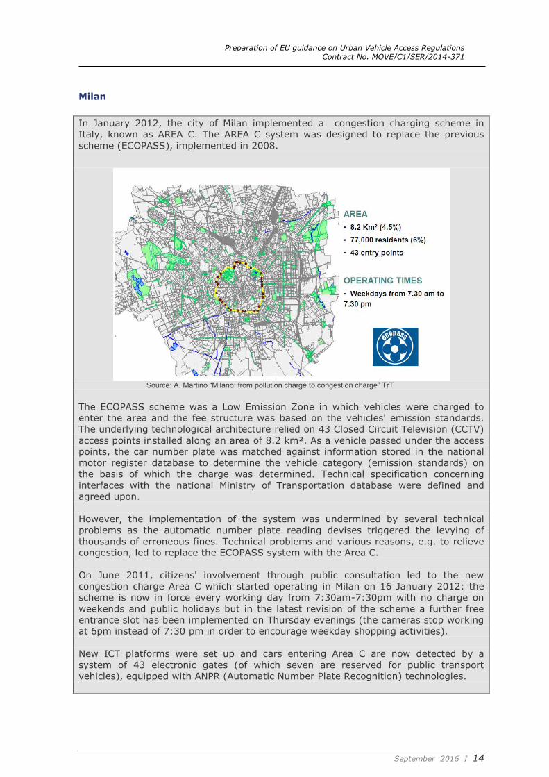
Milan
In January 2012, the city of Milan implemented a congestion charging scheme in
Italy, known as AREA C. The AREA C system was designed to replace the previous
scheme (ECOPASS), implemented in 2008.
Source: A. Martino “Milano: from pollution charge to congestion charge” TrT
The ECOPASS scheme was a Low Emission Zone in which vehicles were charged to
enter the area and the fee structure was based on the vehicles' emission standards.
The underlying technological architecture relied on 43 Closed Circuit Television (CCTV)
access points installed along an area of 8.2 km². As a vehicle passed under the access
points, the car number plate was matched against information stored in the national
motor register database to determine the vehicle category (emission standards) on
the basis of which the charge was determined. Technical specification concerning
interfaces with the national Ministry of Transportation database were defined and
agreed upon.
However, the implementation of the system was undermined by several technical
problems as the automatic number plate reading devises triggered the levying of
thousands of erroneous fines. Technical problems and various reasons, e.g. to relieve
congestion, led to replace the ECOPASS system with the Area C.
On June 2011, citizens' involvement through public consultation led to the new
congestion charge Area C which started operating in Milan on 16 January 2012: the
scheme is now in force every working day from 7:30am-7:30pm with no charge on
weekends and public holidays but in the latest revision of the scheme a further free
entrance slot has been implemented on Thursday evenings (the cameras stop working
at 6pm instead of 7:30 pm in order to encourage weekday shopping activities).
New ICT platforms were set up and cars entering Area C are now detected by a
system of 43 electronic gates (of which seven are reserved for public transport
vehicles), equipped with ANPR (Automatic Number Plate Recognition) technologies.
Preparation of EU guidance on Urban Vehicle Access Regulations Contract No. MOVE/C1/SER/2014-371
September 2016 I 15
Stockholm
The Stockholm congestion charge was introduced as a trial between 3 January 2006
and 31 July 2006. Through a referendum in September 2006, the residents of
Stockholm voted for the reintroduction of the congestion charges in August 2007 and
this has been operational since then.
Source: Jonas Eliasson, KTH Royal Institute of Technology “The Stockholm congestion charges: an overview”
The charging system consists of a cordon with 18 payment gates situated around the
inner city with a time‐differentiated toll being charged in each direction. On 1 January
2016, congestion taxes have been increased in the inner-city parts of Stockholm and
congestion tax has been charged on an additional access pointxv.
Originally the technological framework relied on a combination of RFID technologies
and ANPR for enforcement. Wireless RFID technology was supplied by the Norwegian
company Q-Free. The system worked by using a Q-Free on-board unit and roadside
technology in combination with an operational system. Payments were made via a
number of channels including direct debit triggered by the recognition of the on-board
electronic tag. Q-Free cameras detected and record car number plate images using
Automated Number Plate Recognition (ANPR) software to identify those vehicles
without tags, and were also used to verify tag readings and provide evidence to
support the enforcement of non-payers.
When the charges were reintroduced after the public consultation, the automatic
camera identification ANPR system, originally intended only as a secondary means of
vehicle identification, became the basic technology abolishing the use of transponders,
due to their good performances.
Now vehicles are registered and identified automatically at control points through a
photograph of their number plate. The flow of traffic is not affected as drivers do not
have to stop or slow down. Payment is made in arrears; there is no need to pay at the
roadside.
Preparation of EU guidance on Urban Vehicle Access Regulations Contract No. MOVE/C1/SER/2014-371
September 2016 I 16
DSRC-based technologies
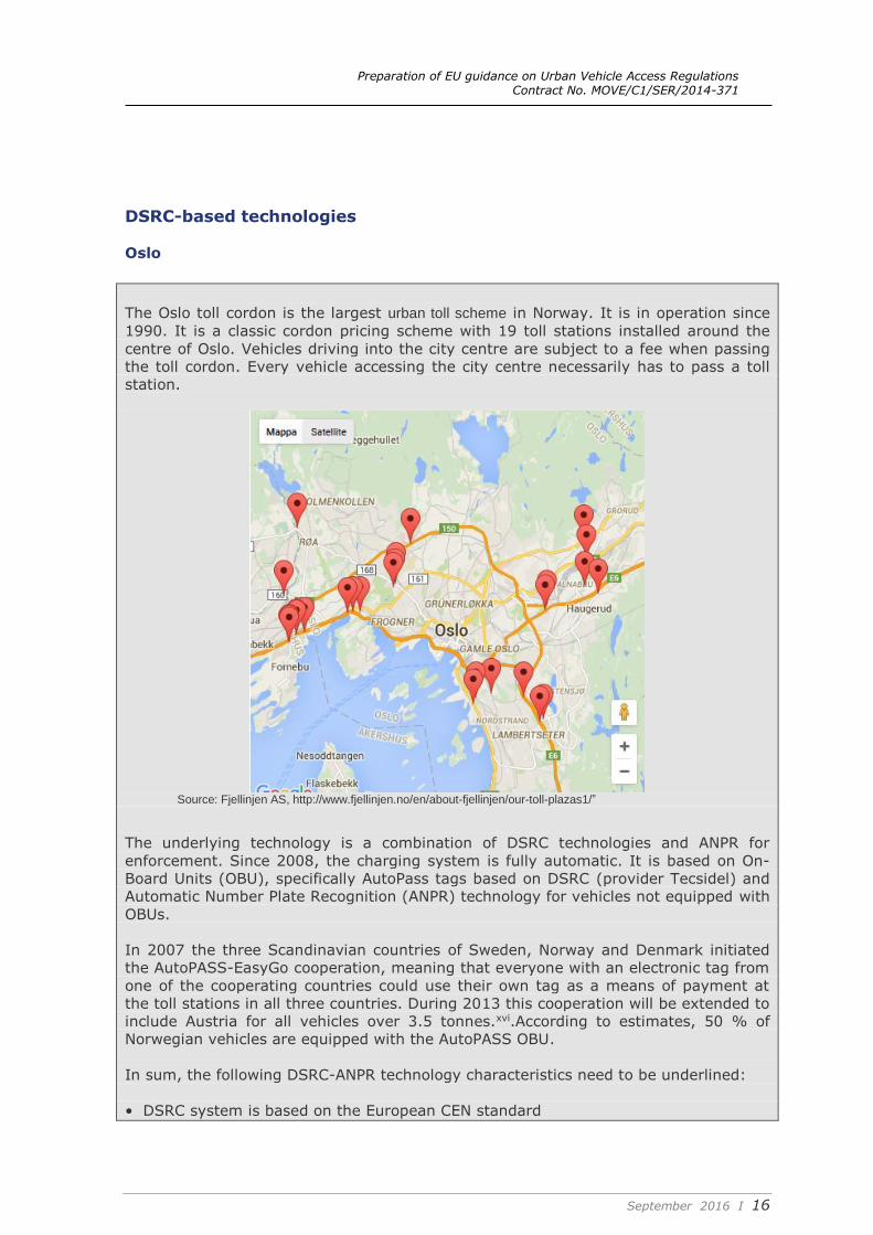
Oslo
The Oslo toll cordon is the largest urban toll scheme in Norway. It is in operation since
1990. It is a classic cordon pricing scheme with 19 toll stations installed around the
centre of Oslo. Vehicles driving into the city centre are subject to a fee when passing
the toll cordon. Every vehicle accessing the city centre necessarily has to pass a toll
station.
Source: Fjellinjen AS, http://www.fjellinjen.no/en/about-fjellinjen/our-toll-plazas1/”
The underlying technology is a combination of DSRC technologies and ANPR for
enforcement. Since 2008, the charging system is fully automatic. It is based on On-
Board Units (OBU), specifically AutoPass tags based on DSRC (provider Tecsidel) and
Automatic Number Plate Recognition (ANPR) technology for vehicles not equipped with
OBUs.
In 2007 the three Scandinavian countries of Sweden, Norway and Denmark initiated
the AutoPASS-EasyGo cooperation, meaning that everyone with an electronic tag from
one of the cooperating countries could use their own tag as a means of payment at
the toll stations in all three countries. During 2013 this cooperation will be extended to
include Austria for all vehicles over 3.5 tonnes.xvi.According to estimates, 50 % of
Norwegian vehicles are equipped with the AutoPASS OBU.
In sum, the following DSRC-ANPR technology characteristics need to be underlined:
• DSRC system is based on the European CEN standard
Preparation of EU guidance on Urban Vehicle Access Regulations Contract No. MOVE/C1/SER/2014-371
September 2016 I 17
• The open standard is owned and managed by the NPRA (Norwegian Public Roads
Administration)
• Standardised hardware and software applies for all the Norwegian urban tolling
projects
• Full national (and Nordic, i.e. Denmark, Sweden and Norway) interoperability
allowing motorists to use the same OBU in all Norwegian and Nordic toll projects;
and
• The AutoPASS system is owned by the NPRA comprising technical specifications,
OBUs and all road side equipment.
In terms of cost effectiveness, approx. 220.000 vehicles pass the toll ring daily (the
road with the most traffic having 46.000 daily). Approx. 40% of all drivers in the Oslo
region pass the toll ring daily. The gross revenue in the last three years (data from
2014) has been more than EUR 80m annually. Operational expenditure is approx.
11% which is significantly less than the cost of administrating taxes. Thus, the toll ring
system might be considered as an effective collection systemxvii.
Lessons learned from the available options
In discussing the technology options available for the implementation of UVAR
schemes, it emerges that the technological options should not be regarded as an
“either-or” but as complementary options.
Among the factors affecting the most appropriate technological combination, it can
also be considered urban topology.
In fact, urban topology matters: in Stockholm and Oslo, where the worst congestion
problems (urban roads) can be located along a natural cordon around the city centre,
the implementation of cordon charging UVAR schemes is viable. In urban areas with
multiple access options such as in Milan or in London, the identification of a cordon is
more difficult.
Cordon charging systems as in Norway or in Stockholm combine Dedicated Short
Range Communication (DSRC) and ANPR technologies. When a vehicle passes a
charging point, it is detected, identified by the on board unit and a charge may be
deducted from the smart card. Vehicles detected without an on board unit or smart
card are photographed for enforcement purposes and Automatic Number Plate
Recognition (ANPR) technology is used to identify exempt vehicles or allow for
enforcement.
However, the roadside equipment (gantries) that needs to be installed to read OBUs in
DSRC solutions may be not compatible with the urban environment as it was
demonstrated in the London trialsxviii.
In dense cities such as Milan or London, using Automatic Number Plate Recognition
(ANPR) technologies is an option. Drivers purchase a permit and their vehicle is then
added to an electronic list; automatic cameras record vehicles crossing cordons (or
entering certain areas) and check number plates against the list.
ANPR-based systems are also appropriate where passenger cars represent the largest
segment of traffic and the number plate identification is reliable according to
technological developments. This solution offers generally low capital and operational
Preparation of EU guidance on Urban Vehicle Access Regulations Contract No. MOVE/C1/SER/2014-371
September 2016 I 18
expenditures. However, back office operation expenditures may grow when the
operation has to deal with a great share of foreign vehicles.
An example of back office activities with an indicative cost estimation is provided in
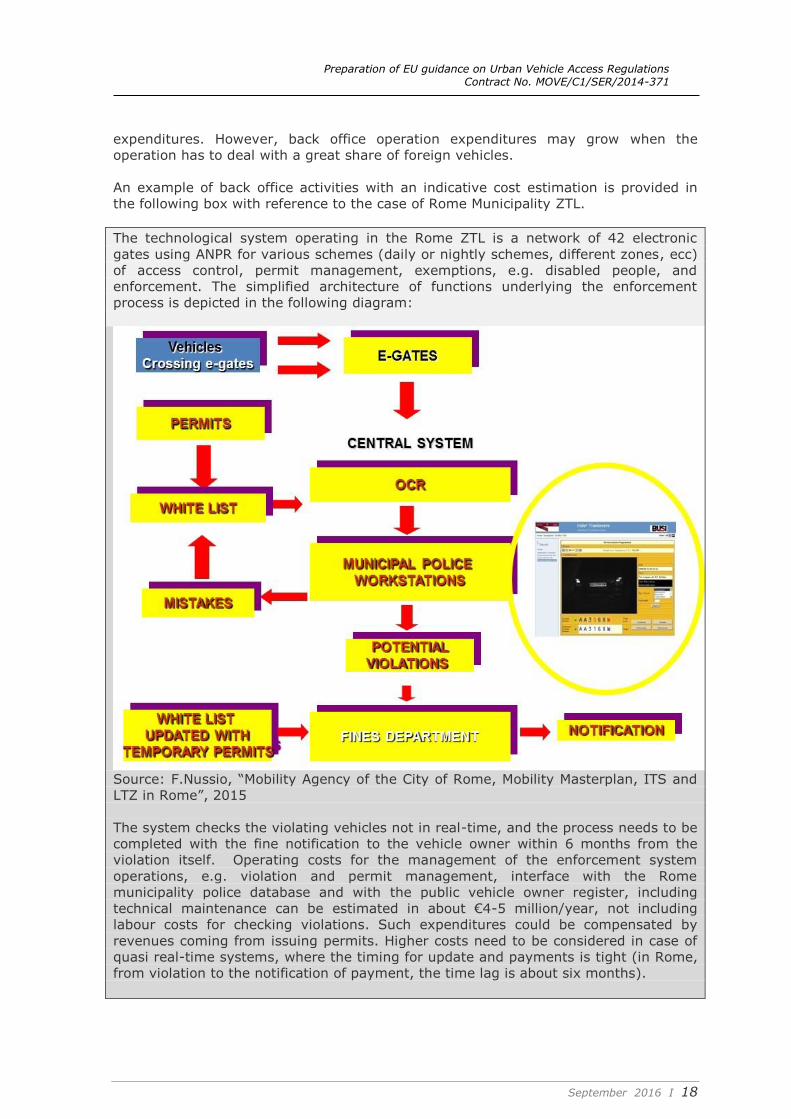
the following box with reference to the case of Rome Municipality ZTL.
The technological system operating in the Rome ZTL is a network of 42 electronic
gates using ANPR for various schemes (daily or nightly schemes, different zones, ecc)
of access control, permit management, exemptions, e.g. disabled people, and
enforcement. The simplified architecture of functions underlying the enforcement
process is depicted in the following diagram:
Source: F.Nussio, “Mobility Agency of the City of Rome, Mobility Masterplan, ITS and
LTZ in Rome”, 2015
The system checks the violating vehicles not in real-time, and the process needs to be
completed with the fine notification to the vehicle owner within 6 months from the
violation itself. Operating costs for the management of the enforcement system
operations, e.g. violation and permit management, interface with the Rome
municipality police database and with the public vehicle owner register, including
technical maintenance can be estimated in about €4-5 million/year, not including
labour costs for checking violations. Such expenditures could be compensated by
revenues coming from issuing permits. Higher costs need to be considered in case of
quasi real-time systems, where the timing for update and payments is tight (in Rome,
from violation to the notification of payment, the time lag is about six months).
Preparation of EU guidance on Urban Vehicle Access Regulations Contract No. MOVE/C1/SER/2014-371
September 2016 I 19
Furthermore, concerning the comparative cost assessment of DSRC and ANPR options,
it should be considered that where DSRC and other methods are used, camera
technology is still also needed to detect those that don’t pay or have OBUs. This gives
another advantage to ANPR enforcement, as it only requires one technology to be
used.
Preparation of EU guidance on Urban Vehicle Access Regulations Contract No. MOVE/C1/SER/2014-371
September 2016 I 20
CHAPTER IV – Potential impacts of a common European approach on technology and interoperability
As mentioned in previous chapters, technological options in UVAR schemes depend on
various factors, notably UVAR functionalities, as well , as city size, traffic conditions,
existing road infrastructures, urban architecture and, last but not least, available
budget.
Depending on the objectives of the UVAR scheme (for instance to limit the access of
certain vehicles to specific areas vs. to reduce congestion vs. to increase the overall
air quality and liveability of the city etc.), technology options and their combination
could also change.
When looking at a common European approach, interoperability more than technology
itself is of the essence.
More interoperability could enable road users to easily obtain access to cities
throughout the EU with a limited a limited number of electronic devices in the vehicle’.
This is more evident in the case of UVAR schemes with similar objectives but it could
also be useful where the objectives are different.
Assuming the common adoption of the “user pays” principle where charges are
directly related to the costs that users impose on the infrastructure, interoperability is
essential to offer road and infrastructure charging policy in a flexible way without
creating obstacles to traffic flows in European cities.
According to the Directive 2004/52/EC and Decision 2009/750/EC, the European
electronic Toll Service (EETS) has to ensure interoperability of tolling services on the
entire European Union road network. With a single service provider, subscription
contract and on-board unit, EETS is supposed to facilitate daily operations for road
users, improve traffic flows and reduce congestion. TOLL2GO and EasyGo are two
current examples in EU. The first is a joint service provided by the German Toll
operator as well as by the Austrian ones. The second is a European partnership
between Denmark, Norway, Sweden and Austria that enables the use of one and the
same OBU at more than 50 toll stations in Denmark, Sweden, Norway and Austria, as
well as many ferry services within Denmark and between Denmark/Sweden and
Denmark/Germany. A similar service could help establish interoperability in European
cities and enable road users to circulate throughout the European Union without
having to be concerned by charging procedures changing from one city to another.
This does not require one single service provider but there should be interoperability
between the different systems so that paying charges would be a seamless operation.
Interoperability could also increase security in the whole of Europe generating useful
information for the relevant law enforcement authorities checking the data against a
common database. In case of no matching data, the recording would automatically be
deleted.
Interoperability could also play a key role for UVARs without a charging scheme. It
should be a part of the EU Directive 2010/40/EU (ITS) and useful integrated services
should be easily be offered and used (e.g. P&R, Rail, public transport system, parking,
car sharing, e-biking, or any smart ticketing system) without having to be concerned
with different procedures, applications and languages.
Preparation of EU guidance on Urban Vehicle Access Regulations Contract No. MOVE/C1/SER/2014-371
September 2016 I 21
In the previous chapters it was demonstrated that ANPR is the most used technology
in European UVARs also due to enforcement reasons, its easy-to-use approach and
relatively lower costs. In addition, the performance and features of ANPR are
continuously improving, enabling new fields of applications. In fact, the global ANPR
system market is expected to grow at a compound annual growth rate (CAGR) of
more than 12% in the next 4-5 yearsxix.
However, the lack of licence plate standardisation and the challenges for Member
State cooperation in setting up a European licence plate database make UVARs' case
for achieving international interoperability weak, other than making interoperability of
cross-border enforcement of penalties problematic.
Preparation of EU guidance on Urban Vehicle Access Regulations Contract No. MOVE/C1/SER/2014-371
September 2016 I 22
CHAPTER V – Barriers and enablers to a common approach
Barriers at local and EU level
ANPR mistakes and license plate standardisation
Demonstrations across Europe show that the technology needed for automatic
number plate recognition (ANPR) is reliable and affordable. It has however an
intrinsic rate of non-recognition in the real operational environment (up to 10%).
Wrong enforcement especially during the launch of the system can create negative
reactions. Non-detection and incorrect reads in ANPR systems can be strongly
reduced by overlapping camera readings and supporting machine systems with
human aid. Hence, the UVAR scheme needs to be supported by a well-tested
operational scheme able to reduce such problems. Furthermore, as mentioned
above, the lack of license plate standardisation at EU level diminishes the
geographical interoperability of ANPR.
GPS/GNSS systems are not yet ready to operate on their own in full-scale UVAR systems.
There are still several problems regarding technology that have to be solved before
a GPS/GNSS system can be implemented in full-scale in UVAR schemes. GPS-based
systems require a OBU installed in all cars crossing the UVAR and such installation
activity is enormous and very costly. Also, much further work needs to be carried
out concerning methodological, software, and technical issues.
UVAR schemes in general and specifically zone charging schemes do not require
continuous monitoring which is a main benefit of GNSS systems. The general
problem with a GPS-based system is that it has to work the whole time the car is in
a charged area. A cordon-based system is much less demanding because the
technology only needs to work when a cordon is crossed which reduces enforcement
to primarily checking vehicles crossing cordons.
Use of GPS/GNSS system for regulated fleet needs to be regulated by contract.
For regulated fleets like coaches for touristic purposes, public transport or delivery
vehicles, the adoption of GPS/GNSS/EGNOS solutions for monitoring and control
purposes need an appropriate regulative framework. A penalty can be applied in
case of non-compliance only in case a law establishing the application of a sanction
is in force and the GPS/GNSS equipment is duly approved.
Equipment could not work properly
Demonstrations in trials and pilot across Europexx have experienced problems with
OBUs regarding loss of battery power, poor quality of GPS reception and loss of
signals notably when the system was set up. Recommendations are to undertake
extensive testing of prototypes before implementing the final product and to check
the quality of the GPS signal received when installing the equipment. For instance,
loss of signals could be compensated by specific technical methods, like dead
reckoning systems and real-time map matching, which are able to calculate the
current position by using a previously determined – or a fixed – position and
updating that position based upon known or estimated speeds over elapsed time
Preparation of EU guidance on Urban Vehicle Access Regulations Contract No. MOVE/C1/SER/2014-371
September 2016 I 23
and trajectory. Running a small-scale pilot that includes analyses of the log data is
also necessary in most cases.
The multi-application functionalities to the on-board unit
The new generation of OBU features long lifetime, compact site and very good
performance at any speed. The user memory can be structured in several elements
and be able to host most common harmonised specifications in tolling as well as for
other applications such as parking, UVAR access, gas stations, logistic management
etc.. This functionality enables interoperability. However, this cannot always be
guaranteed because data structure in the memory has to be defined immediately
after initialization. Afterwards, an update of the software or data of the on-board
unit is subject to multiple requirements. Then the complexity of the system
increases and consequently the sources of errors in all steps of the system
development and operations process may frequently occur. Additional applications
could also interfere with other vehicle features like battery consumption or with
other DRSC/RFID/GPS systems operating in the same environment. Moreover, data
privacy and caution for different application stakeholders sharing OBUs and/or data
need to be considered.
Privacy issues
Despite of the many potential benefits of Intelligent Transport Systems, the
associated increase in vehicle/infrastructure electronics and communications raises
security and privacy issues where ITS technologies must ensure the integrity,
confidentiality and secure handling of data including personal and financial details
ensuring the full protection of citizens’ rights. Concrete guidance on personal data
protection and standards for specific aspects of ITS as in the case of UVAR scheme
application, where path control and full-scale use of GNSS positioning systems could
have wide application for specific fleets and vehicles should be taken into account.
Legal implications for GPS/GNSS/EGNOS position
The attributions to the GNSS position shall be expressed as a “yes/no” values and
not as a percentage in order to have a legal value when associating the detected
vehicle to a specific position. In other words it would be necessary to define a
threshold under which the positioning data are not validated and they have no legal
value. Above the threshold, the data has legal validity as recognised by contract or
law. Such a threshold is a sort of “tolerance” associated to the data and it is related
to the accuracy of the measurement done by the instruments, typically derived from
the testing during the type approval procedure. Currently the type approval process
is based on Member States’ rules and procedures. Specifically for the use of EGNOS
and Galileo features, the definition of European common guidelines to harmonise
the establishment of Member States rules is recommendable, for ensuring
interoperability, compatibility and continuity.
Enablers at local and EU level
ANPR systems work sufficiently well
Due to the intrinsic rate of failure in vehicle recognition, there will probably always
be a small share of vehicles that cannot be identified by the system.
Implementation in London and Stockholm show that after the ANPR system was
implemented, non-compliance diminished drastically. This shows that automatic
systems such as ANPR are more efficient than systems focusing on manual control.
Preparation of EU guidance on Urban Vehicle Access Regulations Contract No. MOVE/C1/SER/2014-371
September 2016 I 24
If the UVAR scheme's objectives call for several zones or time-differentiated fees, it
is advised to use DSRC. Even in this case ANPR should be a necessary complement
for enforcement purposes.
OBUs can integrate ANPR systems
UVAR system can be designed to integrate more technologies. With cordon based
ANPR, the photograph of the non-compliant car's license plate is processed by a
OCR system. Where data reliability does not reach the required threshold, the
photograph is manually controlled and checked against the central database. This
process could be supported by a parallel OBU system where vehicles equipped with
OBUs are automatically authorized removing photo reliability controls and by that
decreasing the operator's workload. Control protocols should in any case be
produced in order to detect incorrect use of the OBU or card and their association to
the license plate.
Use of GPS/EGNOS system to support regulated fleet
For specific fleets subject to regulation in urban areas like public transport, coaches
for touristic purposes or delivery vehicles, a GPS-based system is mostly already
used for monitoring purposes or quality control checks. However, due to the
complex networks and driving environments, other than political or commercial
barriers, a GPS-based system has some limitations like extra costs derived from the
need of visual control and inspections requiring personnel effort in case of claims in
order to verify data reliability.
The possible enhancement of the present GPS-based system is EGNOS OS that
generally improves GPS performances. This development is valid for all extra-urban
and urban environments, for commercial GPS/ EGNOS receivers and antennas with
different enhancements and less valid in cases with dense and tall buildings/ foliage
conditions and of standard antennas. Specific systems like EGNOS CS/EDAS can
provide a higher confidence in the position calculation.
Future adoption of the EGNOS system for regulated fleets could enhance present
applications which are already based on GPS. It could be adopted in present/ future
operations where the use of satellite navigation technology is planned and in order
to develop new applications supporting a more effective regulation of the traffic in
urban and suburban areas and between urban and interurban roads (i.e. urban/
extra-urban interoperability).
Transition to low carbon economy
Transport is the backbone of the economy, essential for the functioning of the single
market and the free movement of goods and people. The global transition towards
a low-carbon economy has started, supported by the Paris Climate Agreement.
Transport will need to play an important role in this transition. In this sense, the EC
communication “A European Strategy for Low-Emission Mobility"1 states that the EC
will propose and create enabling conditions for low-emission mobility, advocating
fair and efficient pricing in transport. Cities account for 23% of transport CO2
emissionsxxi and many urban areas are in breach of air pollution limits. The strategy
will depend on cities and local authorities and UVARs are an important part of a
comprehensive approach towards sustainable urban mobility planning in which
technology choices could support the set-up of flexible areas where applying
different policies to more polluting vehicles.
1 SWD(2016) 244 final.
Preparation of EU guidance on Urban Vehicle Access Regulations Contract No. MOVE/C1/SER/2014-371
September 2016 I 25
VI Recommendations
Taking into consideration the complexity of EU urban areas and the impossibility of
finding a “one size-fits-all” solution, the following recommendations provide indications
on how trading-off the specific characteristics of UVAR technological solutions to
pursue increased interoperability and effectiveness.
When planning UVAR and its associated technology, number plate recognition
(ANPR) technologies should be considered, as they have proven to be reliable
and effective, are cheaper, and easier to implement since they do not require
in-vehicle equipment, though they are probably more expensive to operate, in
terms of back-office expenditures and operational costs. The technology has
also proven to be interoperable with other solutions in electronic toll collection,
e.g. in combination with DSRC technologies. ANPR also has the advantage of
not requiring additional equipment in vehicles, and is also required as an
enforcement method in addition for other technological enforcement methods.
However, the lack of licence plate standardisation and the challenges for
Member State cooperation in setting up a European licence plate database
make UVARs' case for achieving international interoperability weak.
The choice of technology is also influenced by urban topology and UVAR
objectives, e.g. charging. In Stockholm and Oslo, where the worst congestion
problems (urban roads) can be located along a natural cordon around the city
centre, the implementation of cordon charging UVAR schemes is viable. Cordon
charging systems as in Norway or, originally, in Stockholm, combine Dedicated
Short Range Communication (DSRC) and ANPR technologies. The set up of
costly roadside equipment (gantries) in a few important points may be
compatible with specific urban topology. In urban areas with multiple access
options such as in Milan or in London, the identification of cordons is more
difficult. DSRC technologies offer a high level of interoperability with parking
and tunnels, as shown in the Nordic European countries.
Global Positioning System (GPS)/GNSS solutions in urban areas, although
promising in terms of interoperability, face several barriers: in particular,
additional roadside equipment need to be installed to improve signals where
they are weak (e.g. in urban canyons), driving investment costs up. In general,
the appropriate combination of technologies must cope with the everyday
problems, e.g. acceptability, privacy issues, legal problems, technical reliability,
etc. Every combination should be evaluated ex-ante, through an experimental
period where all the particularities of the scheme itself are tested with all the
involved actors and stakeholders.
Preparation of EU guidance on Urban Vehicle Access Regulations Contract No. MOVE/C1/SER/2014-371
September 2016 I 26
i NBGD n° 2 “Vehicle Types, Exemptions and (Cross-border) Enforcement of Successful
Urban Vehicle Access Regulations (UVAR) Schemes across Europe” ii An exhaustive introduction to the key categories, from the point of view of charging
technologies, can be found in “Technology options for the European Electronic Toll
Service”, European Parliament Study 2014 iii Technology options for the European Electronic Toll Service”, European Parliament
Study 2014 iv A review of current development in GNSS applications in Europe is “GNSS Adoption
in Road User Charging in Europe, Issue 1, European GNSS Agency, 2015”. v https://www-03.ibm.com/press/us/en/pressrelease/29507.wss vi S.Kearns, “Congestion charging trials in London”, Trasport for London, 2007 viihttps://www.lta.gov.sg/content/ltaweb/en/roads-and-motoring/managing-traffic-
and-congestion/electronic-road-pricing-erp.html viii TREN/G4/41-2010- SI2.573856 ix Partial, or one way interoperability. happens when a system designed in one country
can be used to pay charges electronically in a second country, but the unit in the
second country cannot be used to pay charges in the first country. xhttp://www.comune.milano.it/wps/portal/ist/it/servizi/mobilita/area_c/modalita_paga
mento xi “Technology options for the European Electronic Toll Service”, European Parliament
Study 2014 xii Directive 2004/52/EC Of The European Parliament and Of The Council of 29 April
2004 on the interoperability of electronic road toll systems in the Community xiii “Technology options for the European Electronic Toll Service”, European Parliament
Study 2014 xiv Trasport for London “Congestion charge factsheet”
http://content.tfl.gov.uk/congestion-charge-factsheet.pdf xv Swedish Transport Administration, “On 1 January 2016, congestion taxes in
Stockholm will be raised and congestion tax will be levied on Essingeleden” xvi, “Road Tolling in Norway – a brief introduction”, Norwegian Public Roads
Administration, Astrid Fortun/Erik Furuseth, 2007 xvii Information from ELTIS database Oslo. Toll ring system
http://www.eltis.org/discover/case-studies/oslo-toll-ring-system xviii S.Kearns, “Congestion charging trials in London”, Trasport for London, 2007 xix Automatic Number Plate Recognition System Market by Type (Mobile, Fixed,
Portable), Application (Traffic Management, Law Enforcement, Toll Collection, Parking
Areas), & Geography - Analysis & Forecast to 2020, December 2015 xx PRogr€SS (Pricing Road Use For Greater Responsibility, Efficiency And Sustainability
In Cities Competitive and Sustainable Growth Programme), at an early stage to
EGNOS2Road (2010) assessing the added value/ economic benefits of EGNOS with
respect to the GPS for the road sector xxi EC communication SWD(2016) 244 Final