temporal rainfall fluctuations in israel and their
TRANSCRIPT

Temporal rainfall fluctuations in Israel and their possible link to urban and air pollution effects
This article has been downloaded from IOPscience. Please scroll down to see the full text article.
2009 Environ. Res. Lett. 4 025001
(http://iopscience.iop.org/1748-9326/4/2/025001)
Download details:
IP Address: 132.66.152.34
The article was downloaded on 24/05/2009 at 08:18
Please note that terms and conditions apply.
The Table of Contents and more related content is available
HOME | SEARCH | PACS & MSC | JOURNALS | ABOUT | CONTACT US
IOP PUBLISHING ENVIRONMENTAL RESEARCH LETTERS
Environ. Res. Lett. 4 (2009) 025001 (12pp) doi:10.1088/1748-9326/4/2/025001
Temporal rainfall fluctuations in Israeland their possible link to urban and airpollution effectsNoam Halfon1,2, Zev Levin2 and Pinhas Alpert2
1 The Porter School of Environmental Studies, Tel Aviv University, 69978, Israel2 The Sackler Faculty of Exact Sciences, Department of Geophysics and Planetary Science,Tel Aviv University, 69978, Israel
Received 25 July 2008Accepted for publication 16 April 2009Published 19 May 2009Online at stacks.iop.org/ERL/4/025001
AbstractIn this paper we analyze spatial variations of the annual rainfall that have taken place in thenon-arid regions of Israel (annual rainfall > 200 mm) during the years 1952–2006,incorporating all available data. The results of the present study over the research area as awhole indicate that no significant temporal change of the annual rainfall occurred in any regionof the study area. However, focusing on spatial rainfall fluctuations between sub-regions in thestudy area, a significant increase was observed between the stations located downwind andthose upwind of the Greater Tel Aviv region.
This increase supports previous reports showing that rainfall enhancement is observeddownwind (and close) to urban centers. In contrast to a few previous reports, no decrease in theratio between the mountain precipitation to that over the coastal region was found. Over theperiod of the present study, the rainfall ratio between the upwind slopes and the seashoreremained unchanged, with a slight increase in the central part of the country.
The only hilly place where a slight decrease in annual rainfall was observed is the lee side(eastern slopes) of the Galilee Mountains. This result is important because the eastern slopes ofthe Galilee Mountains have for years been part of the target area for Israeli artificial cloudseeding for rain enhancement. The results therefore suggest that unless there was a pronouncedchange in the synoptic conditions during rain spells, seeding in Israel had no positive effect onrainfall amounts.
Keywords: urban, rainfall, air pollution, aerosols, Israel
1. Introduction
The effects of aerosols on clouds have been widely studied.It is clear that increased aerosol concentrations, especiallythose that serve as cloud condensation nuclei (CCN) leadto smaller and higher concentrations of cloud drops. Inwarm clouds these effects slow down the development ofprecipitation due to the slower growth of hydrometeors bycollection. The effects on clouds that contain both waterdrops and ice (mixed-phase clouds) are not yet clear, althoughthere are observations and modeling studies suggesting thatice formation would occur higher up in the clouds, leading tohigher or lower precipitation depending on the environmental
conditions and on the interaction with the surroundingenvironment.
Measurements downwind of sugarcane fires first sug-gested a suppression of precipitation (Warner and Twomey1967, Warner 1968) that was thought to be associated with thereduced efficiency of precipitation development due to an in-crease in CCN from the fires. However, Warner (1971) couldnot rule out the possibility that the decrease in rainfall wascaused by changes in meteorological conditions. Hobbs et al(1970), on the other hand, observed increases in precipitationdownwind of paper mills in Washington State. Although thepresence of giant CCN was thought to be responsible for theobserved increases, Hindman et al (1977) concluded that giant
1748-9326/09/025001+12$30.00 © 2009 IOP Publishing Ltd Printed in the UK1
Environ. Res. Lett. 4 (2009) 025001 N Halfon et al
CCN by themselves could not fully account for the observa-tions and that other factors related to the environmental mete-orological parameters are the dominant factors.
Analyses of precipitation downwind of urban areas carriedout in the USA (Changnon et al 1976, 1977, 1981, Hjemfelt1982, Huff 1977) showed increases in precipitation over theyears especially in the summer season when rain is moreconvective. All the studies attributed these increases to urbaneffects, such as the urban heat island as well as changes in soilmoisture and in roughness parameters affecting wind speed andconvergence. More recent papers reached similar conclusions(Thielen et al 2000, Shepherd et al 2002, Shepherd and Burian2003).
Most of the rain in Israel occurs in the winter due to thepassage of cold fronts from the west. In addition, rainstormsfrom the Red Sea Trough sometimes bring local heavy rains,but their contribution to the total water budget of the region issmall (Goldreich et al 2004).
Investigations conducted in Israel over the past fewdecades observed increases in precipitation in winter stormsdownwind of the two major urban areas in the country, Tel Avivin the center of the country and Haifa in the north (Goldreich1981, 1990, 1995, 2003, Goldreich and Manes 1979, Goldreichand Kaner 1991). Shafir and Alpert (1990) showed positiveurban effects on rainfall over Jerusalem. Goldreich (1995)stated that although the statistical significance of each of thesefindings was not so high, the fact that all the reports reachedsimilar conclusions using different techniques is a goodindication that urbanization plays a role in the enhancementof rainfall downwind.
A hypothesis that a negative correlation exists betweenpollution levels and amounts of orographic precipitation dueto the microphysical effects of aerosols on clouds has recentlybeen proposed by Givati and Rosenfeld (2004, 2005, 2007). Inthese reports similarities were found between the suppressionof orographic precipitation in winter storms in California andIsrael. The results are based on temporal trends of the annualratio, Ro, between mountainous stations and stations upwind(west) of the mountain. These findings are not supported byprevious findings in Israel that showed only changes in thegradient of precipitation between the north and the south ofthe country (Ben-Gai et al 1994, 1998, Steinberger and Gazit-Yaari 1996, Zangvil et al 2003, Krichak et al 2002). Alpertet al (2008), utilizing the same method of orographic ratioanalysis used by Givati and Rosenfeld (2004, 2005), but withmore representative stations, found no real changes in the ratiobetween the amounts of annual rainfall in the mountains and atthe seashore.
In the light of these conflicting results, it was decided toconduct a comprehensive climatological investigation of therainfall, making use of all the available data in the study area(∼500 rainfall measurements per year), including some newlyavailable data from over 50 stations in the West Bank. Inthis way, one can objectively evaluate the temporal changesin precipitation in Israel, with a special emphasis on the effectsof the upwind urban regions on the rainfall downwind in theplains and the mountains.
2. Methods
Because of the inhomogeneous distribution of rain gaugestations in the study area, we analyzed the data and comparedthe results using four different methods: (1) a geographicalinformation system (GIS) for computing annual rainfall maps,(2) a multivariable regression method, (3) computation of themean regional measured rainfall, (4) temporal rainfall ratiotrends between individual stations. These methods permit theuse of all the available data from the studied period and thusavoid dealing with the question of which rain gauge stationsbetter represent the studied area. It should be emphasizedthat in order to be as objective as possible, rain gauge stationswith incomplete data records were not modified and were notcompleted (filled in) with data from neighboring stations.
2.1. Method 1—GIS computed annual rainfall maps
In this method we mapped all the available annual precipitationdata in the non-arid regions of Israel (i.e. central and northernareas) and compared the amount of rain over the mountainswith that over the seashore (see the detailed procedure infigure 1).
The analysis period was chosen to be from 1952 to 2006(54 years) because it corresponds to a period in which datafrom a high density of rain gauge stations are available. Thismeans that the procedure outlined in figure 1, mapping andcomputing annual means, was repeated 54 times, separatelyfor each year.
More than 25 000 annual rainfall values were mapped(about 500 per year) over an area of 14 000 km2 (seethe research area in figure 2), a high density of about1 station/30 km2. The data were received from theIsraeli Meteorological Service which routinely maintains andcalibrates the rain gauges. Almost all the data were measuredby standard gauges which have an accuracy of 1–2%. A fewper cent of the measurements were done by ‘tipping bucket’rain gauges which have an accuracy of 7%.
In order to improve the accuracy of the maps we definetwo parameters: (1) the mean annual rainfall, which reflectsthe effects of station elevations, latitudes and distances fromthe seashore on the amount of rainfall and (2) the actualamount of rainfall in each station in a specific year, whichreflects the interaction between the geographical position ofthe stations and the synoptic conditions during specific rainyspells. Dividing the actual amounts of rainfall by the longterm averages allows us to neutralize the average influence ofgeography on precipitation and to interpolate only the spatiallyrandom deviations from the mean. Another advantage ofmapping relative amounts (actual amounts divided by the meanannual rainfall) is that the spatial mean of the mapped region isnot strongly affected by occasional changes in the distributionof rain gauges in the study area.
The definition of the areas that were compared to eachother was based on the topography (see figure 2(a)) and thewind direction during rainy spells (figure 2(b)). The mountainregion in the north of Israel included all the areas above an
2
Environ. Res. Lett. 4 (2009) 025001 N Halfon et al
Figure 1. Flowchart of the mapping procedure and the computing process of the annual mean precipitation for each of the six zones ofinterest. ∗ The weight of the inverse distance weighted (IDW) interpolation method was defined objectively by the ‘Geostatistical Analyst’tool (ESRI 2004) according to the spatial distribution of the stations and their values in each year. The number of neighbors to include in theinterpolation was set at 10. ∗∗ The central downwind slope region was not used in the analysis because of its sparse rain gauge network andbecause most of it is located in the semi-arid and arid zones (all the other zones of interest are characterized by a Mediterranean climate).∗∗∗ In the central strips only, after cropping the rainfall maps and computing the annual spatial mean for each of the three zones (seefigures 6(d)–(f)) we subdivided each of them into two parts: the northern part which contains the Greater Tel Aviv urban area and itsdownwind region, and the southern part which is characterized by a more open and rural area (see their geographic extent in figure 2(a)).Then, we computed the annual spatial mean for each of the new sub zones (see figure 7).
altitude of 400 m,3 and was divided into two parts: northernupwind slopes (Nu) that also included the stations at themountain top, and northern downwind slopes (Nd) that arelocated more than 1 km east of the watershed line4. In thisstudy, precipitation on both Nu and Nd were compared withthe northern coastal region (Ns); a narrow strip of land alongthe coast (<5 km from seashore) located upwind of the UpperGalilee Mountains.
The criterion used for the mountains in central Israel wasthe same as the one in the north; however, only the upwindslopes and mountain top stations were used (Cu), because of
3 In all analyses referring to the height criterion we placed smooth heightvalues instead of using single point height because the orographic enhancementof precipitation responds predominantly to increase in general elevation.Smoothing was performed for an average height with an area of 16 km2 aroundeach cell following the procedure of Halfon and Kutiel (2004), who foundthat this type of averaging gives the highest correlation between altitude andamounts of annual precipitation at stations in northern Israel.4 Data from the Golan Heights are only available since 1968, therefore, thisregion has not been included in the present analysis.
the insufficient number of rain gauge stations on the downwindslopes and the arid nature of this region. The central coastalregion (Cs, central shore) was defined as a narrow strip, similarto the one in the north. Parallel to it, we defined anotherstrip located about 10–15 km inland (Cp, central plain), mostlydownwind of the Greater Tel Aviv urban region. The separationinto Cs and Cp was required in order to better identify anypotential urban effects in the central plain.
The central coastal plain is not urbanized homogeneously.The northern portions of the central mountains (the SamariaMountains) are located downwind of the main urban areasof Israel while the southern portions (the Judean Mountains)are located downwind of a less urbanized region, althoughpolluted to some extent. For this reason the central regionwas subdivided into two parts. The analysis was carried outonce for the region as a whole and then repeated for each partseparately (see all the study regions in figure 2(a)).
In addition to evaluating the ratio of the average annualprecipitation between the different regions, we also mapped
3

Environ. Res. Lett. 4 (2009) 025001 N Halfon et al
a b.
Figure 2. The study area. (a) Physical map and zones of interest for this research. (b) Annual precipitation map and mean wind direction at850 hPa level during rain5 . (c) Temporal trend of annual rainfall during the study period.
the temporal trend of precipitation in each cell of the annualrainfall maps. This was done by sorting the 54 annual rainfallgrids chronologically (figure 2(c)).
2.2. Method 2—multi-parameter regression
The method of multi-parameter regression also permitted acomprehensive analysis of the data and served as a backupand validation for the mapping analysis (Method 1) describedabove. In this method the spatial variation of the amounts ofannual precipitation in the rainfall stations was described as afunction of geographical parameters such as latitude, distancefrom the seashore (equivalent to longitude) and topographicalheight (averaged over 16 km2 around each station).
Using all the stations in the research area over northernIsrael (see figure 3(a)) we calculated by regression analysis themain rainfall controlling factors for all 54 years of the study.
The two most important variables that were obtained in theregression analysis were the topographical height (significantin all the years) and the distance from the seashore (significantin 52 out of 54 years). The orographic enhancement ofprecipitation and the decline of precipitation with distancefrom the seashore both depend on the precipitation in eachspecific year. We therefore tested the temporal variations ofthese two factors in relation to the mean annual amount of
5 Mean wind direction for central and southern coastal plain was computedby the sounding data of Bet Dagan (marked by a black square) during rainydays within the period 1957–2004 (using two measurements per day: 11zand 23z). The mean data were weighted separately by the mean daily yieldsin the southern stations (marked by blue) and in the central stations (markedby yellow). The wind direction during rain in northern Israel was computedafter averaging the sounding measurements in Bet Dagan and Beirut airport(location 33, 50′N 35′29E) during days with parallel measurements in bothsites within the period 1957–2004. The sounding data were weighted by themean daily rainfall yields in 11 northern stations (marked by red).
precipitation in all the northern seashore stations (0–4 km fromthe sea) in each year (see figures 3(b)–(e))6.
In addition to the general evaluation of the variation inorographic precipitation in northern Israel, we also evaluatedmore specifically the changes in the orographic contribution torainfall amounts on the upwind slope (western) and downwindslope (eastern) of the Galilee Mountains. For this purposewe sampled all the rain gauge stations on both slopes of theUpper Galilee that are over 350 m above sea level (asl). Foreach year, the residuals between the measured and calculatedamounts based on the regression formula were determined,leaving out the coefficient of the orographic influence. Theannual orographic enhancement was calculated by dividing theresiduals in each station by the station’s height. This annualvalue was then averaged separately for the stations locatedon the upslope (including the crest) and downslope of themountains. The annual values for each of the slopes weredivided by the mean annual rainfall in the northern coast for thereason explained in the paragraph above (figures 3(d) and (e)).
2.3. Method 3—mean regional observed rainfall
Method 2 could not be used in the central part of Israel becausethe mountain, the coast and the seashore regions have differentdistributions of rain gauge stations. Most of the stations arelocated in the coastal and seashore regions and there are onlya very few stations on the east side of the watershed line. Thismakes it difficult to develop a reliable regression formula toexplain the spatial variation of rain by geographical factors(topography, latitude, and distance from the seashore) as donein the north of the country (less than 50% of the annualexplained variance in comparison to 65–75% in the north). We
6 The shoreline is a good indicator for annual potential of precipitationbecause almost all the rainfall in the study area comes from maritime cloudstraversing the coastline on their way inland (Goldreich et al 2004).
4

Environ. Res. Lett. 4 (2009) 025001 N Halfon et al
Figure 3. (a) Location of rain gauges used in multi-regression equations fitted in order to describe the annual rainfall distribution by threegeographical factors: altitude, distance from shore and latitude. (b) Annual orographic enhancement for 100 m of altitude in comparison to theannual precipitation of the northern coastal stations (marked in yellow). (c) Annual precipitation decline with distance from the shoreline(compared to the mean annual precipitation in the coastal stations). (d) As in (b) but only for Galilean downwind stations (marked in darkblue). (e) As in (b) but only for Galilean upwind stations (marked in pale blue). See method in section 2.
therefore used a different method for this region. For eachyear all measurements in the central coastal strip (0–4 kmfrom shore), the inner coastal plain (8–16 km from shore)and the Samaria Hills (>350 asl) were averaged separately.Annual ratios between these three regional averages werecomputed and temporal trends of these ratios were recorded(see figure 4)7.
Since some of the stations have been relocated from oneplace to another during the study period, and it was impossibleto neutralize this effect with regression calculations, pre-evaluation of the stations was performed. This was done bycalculating the annual geographical center of gravity of thestations (the mean altitude, longitude, and latitude of all activestations in a certain year) in each of the three clusters. Fromfigure 4(a) it is clear that the shift in the location of the centerof gravity in the three clusters is minor, especially on the east–west axis, which is the most important factor in determining theprecipitation in the central coastal plain of Israel. This impliesthat the small changes are not obstacles for using the methodto evaluate the ratio of the mean spatial annual precipitation.
7 Because of the scattered distribution of the annual ratios, trend lines inthis figure and in figures 6 and 7 are calculated based on the least absolutedeviations method which is more robust and less sensitive to extreme valuescompared to the least squares method.
Evaluation of the mean elevation of the mountainouscluster stations during the study period revealed that there wasa shift downward (during the years more stations appeared ormoved to lower elevation; see figure 4(b)). Since there wasno change in the observed mean annual precipitation in themountainous region it implies that a slightly greater orographicenhancement factor occurred. This is because the same meanprecipitation is obtained with stations located lower down.
The stations in Samaria with long records stoppedreporting rainfall data in 1998, after 46 years of continuousmeasurements from 1952.8 The analysis for this region wastherefore, limited to this period. The ratio between the seashoreand the inner plane strips was calculated up to 2006.
2.4. Method 4—temporal rainfall ratio trends betweenindividual stations with a long record
This last method consisted of an individual inspection of thetemporal trends of the precipitation ratios between each long-lived station in each of the three geographical strips and eachstation in the other strips. The aim of using this method was
8 There are a number of new stations in the Israeli settlements in Samariawhich are still operating, but their spatial distribution is totally different thanthe distribution prior to 1998.
5

Environ. Res. Lett. 4 (2009) 025001 N Halfon et al
Figure 4. Time series of the ratio between mean annual rainfalls in three strips located next to the most populated area of Israel. (a) Locationsof rain gauges. (b) Altitude changes along the study period of the center of gravity of the hilly stations10 . (c)–(e) Annual ratios between themean precipitation amounts in hilly and coastal bands stations, hilly and inland bands, and inland and coastal bands, respectively. Thetemporal trend lines in this figure and in figures 6 and 7 (which also deal with annual ratios) are calculated based on the least absolutedeviations method. This method is appropriate for use with such a scattered distribution of the annual ratios because it is more robust and lesssensitive to extreme values than the least squares method.
to increase confidence in the results obtained by the otherthree methods. In order to evaluate temporal trends, onlystations with data from over9 30–45 years were used, providedthat this minimal threshold was obtained almost consecutively(not more than a 2 year break). The rainfall ratio betweentwo stations was calculated only when their simultaneousmeasurements fitted the above criterion.
After evaluating the precipitation ratios between thedifferent stations (separately for the north and the center ofthe country), the average slopes and the standard deviation foreach region were calculated. Following these calculations, theresults were stratified for each station, based on the percentageof cases in which the slopes exceeded one half of the standarddeviation above (below) the mean (positive (negative) slopes)and the percentage of slopes that fell within one half of thestandard deviation above and below the mean (neutral slopes).The percentage of the ratios in each slope category is presentedin figure 5.
9 In order to obtain a similar number of stations in the three strips in northernand central Israel, we chose a flexible criterion for selecting stations. In theplains, where more rain gauges were available, a station was selected if datawere available from a period of at least 45 years. In the mountainous regionthe minimum number of years was set at 30 in the northern mountains and 40in the central ones.10 Most of the Samaria Hills stations stopped reporting rainfall in 1998. Forthis reason except for (e) (which does not involve the data from Samaria) allthe other time series in figure 4 end in 1998.
3. Results
Before discussing in detail the results for each region, onegeneral observation emerges from figure 2(c): almost all of theresearch area is characterized with minor temporal correlationcoefficients (−0.1–0.2), implying that no significant temporalchange of the annual rainfall had occurred at any place in thestudy area.
In the light of these results we should now focus on thedifferent regions using the methods discussed above.
3.1. Northern Israel
In northern Israel the temporal trend of the rainfall is generallypositive over the coastal plain and the western Galilean slopes.The positive values decline eastward, turning to negativeover the lee side of the Galilee Mountains (see the temporaltrend map in figure 2(c)). Another important fact exposedin figure 2(c) is that the highest positive temporal changewas registered a few kilometers downwind of the Haifa Bayurbanized zone and not onshore.
Evaluation of the annual rainfall ratio between thedifferent topographical regions in northern Israel is illustratedin figure 6, which shows that during the years there was nosignificant change in the ratios between the upslope of theGalilee Mountains (western Galilee) and the coastline strip(figure 6(a)). Similarly, no significant trend was observed in
6
Environ. Res. Lett. 4 (2009) 025001 N Halfon et al
Figure 5. Temporal trend frequencies of the ratio between annual rainfall in long record stations and each of the stations in the parallel bandsin northern Israel (a) and central Israel (b). For instance, for each map, a station marked with a full red circle indicates that ALL the slopes ofthis station’s rainfall ratio with ALL the indicated stations are negative. Outstanding stations relative to the trends in their neighborhood(numbered 1, 2 and 3) are referred to in the text and are named Baram (6a), Shomrat (6a) and Mazrat e-Sharqia (6b), respectively. Such casescould result from measurement problems or from occasional mesoscale storms that coincidentally precipitated more over this station than overits surrounding areas. It worth noting that randomly sampling these stations in order to represent the regional rainfall regime can causemisleading interpretations of the climatic situation in the respective area.
Figure 6. Time series of the ratio between the mean annual rainfall of geographical bands in Israel: (a) northern upwind slopes (Nu)/northernshore (Ns); (b) northern downwind slopes (Nd)/northern shore; (c) northern upwind slopes/northern downwind slopes; (d) central upwindslopes (Cu)/central shore (Cs); (e) central upwind slopes/central plain (Cp); (f) central plain/central shore (see exact location in figure 2(a)).In (a) and (b), the year 1968 stands out with a very high value illustrating the high spatial variability of precipitation even in regions locatedvery close to each other and on the same track of the precipitating clouds.
the ratio between the annual precipitation on the lee side of theGalilee Mountains (eastern Galilee) and the northern coastalstrip (figure 6(b)). A slight and insignificant increasing trend
in the annual precipitation ratio is observed in Galilee itself,between the western slopes of the Galilee Mountains and thelee slopes (figure 6(c)).
7
Environ. Res. Lett. 4 (2009) 025001 N Halfon et al
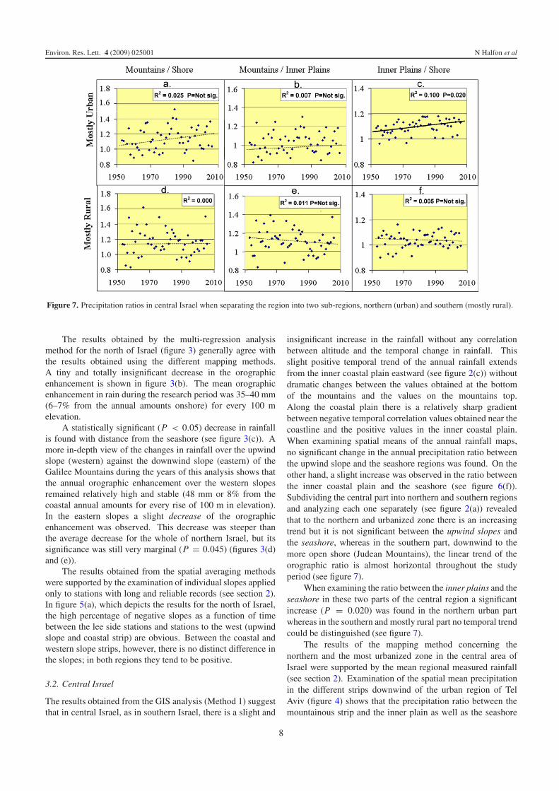
Figure 7. Precipitation ratios in central Israel when separating the region into two sub-regions, northern (urban) and southern (mostly rural).
The results obtained by the multi-regression analysismethod for the north of Israel (figure 3) generally agree withthe results obtained using the different mapping methods.A tiny and totally insignificant decrease in the orographicenhancement is shown in figure 3(b). The mean orographicenhancement in rain during the research period was 35–40 mm(6–7% from the annual amounts onshore) for every 100 melevation.
A statistically significant (P < 0.05) decrease in rainfallis found with distance from the seashore (see figure 3(c)). Amore in-depth view of the changes in rainfall over the upwindslope (western) against the downwind slope (eastern) of theGalilee Mountains during the years of this analysis shows thatthe annual orographic enhancement over the western slopesremained relatively high and stable (48 mm or 8% from thecoastal annual amounts for every rise of 100 m in elevation).In the eastern slopes a slight decrease of the orographicenhancement was observed. This decrease was steeper thanthe average decrease for the whole of northern Israel, but itssignificance was still very marginal (P = 0.045) (figures 3(d)and (e)).
The results obtained from the spatial averaging methodswere supported by the examination of individual slopes appliedonly to stations with long and reliable records (see section 2).In figure 5(a), which depicts the results for the north of Israel,the high percentage of negative slopes as a function of timebetween the lee side stations and stations to the west (upwindslope and coastal strip) are obvious. Between the coastal andwestern slope strips, however, there is no distinct difference inthe slopes; in both regions they tend to be positive.
3.2. Central Israel
The results obtained from the GIS analysis (Method 1) suggestthat in central Israel, as in southern Israel, there is a slight and
insignificant increase in the rainfall without any correlationbetween altitude and the temporal change in rainfall. Thisslight positive temporal trend of the annual rainfall extendsfrom the inner coastal plain eastward (see figure 2(c)) withoutdramatic changes between the values obtained at the bottomof the mountains and the values on the mountains top.Along the coastal plain there is a relatively sharp gradientbetween negative temporal correlation values obtained near thecoastline and the positive values in the inner coastal plain.When examining spatial means of the annual rainfall maps,no significant change in the annual precipitation ratio betweenthe upwind slope and the seashore regions was found. On theother hand, a slight increase was observed in the ratio betweenthe inner coastal plain and the seashore (see figure 6(f)).Subdividing the central part into northern and southern regionsand analyzing each one separately (see figure 2(a)) revealedthat to the northern and urbanized zone there is an increasingtrend but it is not significant between the upwind slopes andthe seashore, whereas in the southern part, downwind to themore open shore (Judean Mountains), the linear trend of theorographic ratio is almost horizontal throughout the studyperiod (see figure 7).
When examining the ratio between the inner plains and theseashore in these two parts of the central region a significantincrease (P = 0.020) was found in the northern urban partwhereas in the southern and mostly rural part no temporal trendcould be distinguished (see figure 7).
The results of the mapping method concerning thenorthern and the most urbanized zone in the central area ofIsrael were supported by the mean regional measured rainfall(see section 2). Examination of the spatial mean precipitationin the different strips downwind of the urban region of TelAviv (figure 4) shows that the precipitation ratio between themountainous strip and the inner plain as well as the seashore
8
Environ. Res. Lett. 4 (2009) 025001 N Halfon et al
did not decrease at all. In fact, just the opposite, where theratio between the Samaria upwind slope and the seashore stripshows a significant increase (P = 0.016 see figure 4(c)). It isworth noting that figures 4(c) and 7(a) show that the orographicratios have short term nonlinear fluctuations during the studyperiod that are not correlated with anthropogenic effects suchas the continuous increase in the population of the Greater TelAviv region during the study period.
A more linear and statistically significant increase wasfound in the ratio between the annual precipitation in the innercoastal strip against the seashore stations (figure 4(e)). Thiscorroborates the results obtained with the mapping method(Method 1), but with even higher statistical significance (p =0.005).
The negative temporal changes of the rainfall on theshoreline in comparison with the plains and mountainsdownwind of the Greater Tel Aviv urban area is also evidentfrom the slopes method (figure 5(b)). Most of the slopes of therainfall ratios between coastal stations and inland strips (innerplain and Samaria) were negative. Positive slopes in the coastalstrip were obtained just in the southern edge of the centralregion south of the Greater Tel Aviv area (figure 5(b)). Thisexplains the positive tendency of the temporal rainfall ratiosbetween stations in both mountainous and inner plain stripsand stations in their adjacent strips (figure 5(b)).
4. Discussion
The main findings of this study are in agreement with previousworks over the past few decades. The weak positive (increase)trends in rainfall that we observed in the southern area are inagreement with similar findings in the south-western part ofthe research area by Ben-Gai et al (1994, 1998), Steinbergerand Gazit-Yaari (1996), Zangvil et al (2003) and Alpert et al(2008), although these investigations were conducted overperiods that are somewhat different from the present one.On the other hand, the reported decrease in precipitation innorthern Israel (Ben-Gai et al 1994, 1998, Steinberger andGazit-Yaari 1996, Givati and Rosenfeld 2005) was foundonly in the eastern part of the Galilee Mountains, and noton the western slopes or in the northern coastal strip. Thedifference between the above studies and the present one couldbe related to the different periods analyzed or to the fact thatin these studies the Galilee region was analyzed as if it is onehomogeneous region, thus smoothing local variations that werefound in the present work. Furthermore, since the easternGalilee has a high concentration of rain gauges, previousstudies have given it a higher weight than other northernregions.
The present results confirm, with higher resolution, theresults of Alpert et al (2008) and strengthen their conclusionthat contradicts the works of Givati and Rosenfeld (2004,2005), suggesting that suppression of precipitation occurredand that it is attributed to the effects of air pollution onorographic precipitation.
The decrease in rainfall over the lee slopes of the GalileeMountains that was reported by Givati and Rosenfeld (2005,2009) was also observed here but is not significant. According
to Givati and Rosenfeld (2004) lee slopes should have receivedsome increases in precipitation as a compensation for thesuppression that should occur on the upwind slopes. However,in this study no decrease in rainfall ratio between the upwindslopes of the mountains against the coastal regions was found.It is shown here that downwind of the main urban regionof Israel (Tel Aviv) an increase in the ratio of mountainprecipitation to the coastal region occurred (significant by onemethod and insignificant by others),
One of the main reasons that Givati and Rosenfeld (2004)found the opposite trends in the central part of Israel isrelated to the choice of stations to represent the upwindregion of the mountain. They chose stations located in andslightly downwind of the urban region, stations that have beenshown here and by Alpert et al (2008) to have an increasedprecipitation ratio against the seashore stations. Southwardto the Greater Tel Aviv urbanized area the rainfall ratiobetween the inner plains and the coast remained unchanged,supporting the urban rainfall enhancement. These findings arein agreement with earlier reports by Goldreich (1981, 1995,2004) and Goldreich and Manes (1979) who also suggestedthat urban effects could be responsible for an increasing trendin precipitation downwind of the Tel Aviv urban sprawl.
Downwind of Haifa Bay we also observe a narrow stripwith a relatively higher temporal rainfall change with respect toits surrounding area. This is also in line with Goldreich (1990)who argued that this specific area had undergone the strongestpositive change between the rainfall averages of 1931–1960and those of 1961–1990, suggesting that it was the resultof urban enhancement. It should be stated, however, thataccording to the present findings, the rainfall enhancementdownwind of the Haifa urban area is insignificant.
Most reports about urban effects on precipitation aroundthe world were related to summer convective precipitation. Thefact that similar effects are shown to be operating in winterstorms in the eastern Mediterranean is in agreement with thework of Altaratz et al (2001) who showed that in this regionconvective activity and the development of thundercloudsreach their maximum intensity in the winter season.
In addition to the urban explanation of the rainfall trendbetween inner plains and the coast (increasing instability,changes in friction and mechanical convection, etc) there couldalso be other dynamical explanations such as variations inthe interaction of synoptic flows with coastal convergence.The south-eastern coast of the Mediterranean creates a regionof convergence that enhances convection (Rosenfeld 1986,Sharon and Kutiel 1986, Alpert and Getenio 1988, Khainet al 1993, 1996). Although the increase in precipitationappears near the coast (Rosenfeld 1986), there is a shorttime lag until the rainfall enhancement caused by theconvergence is seen at the ground. Thus, the maximum rainfallappears a few kilometers downwind of the coast (Goldreich1994). Strengthening of the convergence zone in the easternMediterranean due to thermal or dynamical changes (that havenothing to do with local anthropogenic effects) can increasethe difference in precipitation between the inner coast and thesea. On the other hand, the fact that this increasing ratio trendreaches its peak downwind of the major urbanized areas and is
9
Environ. Res. Lett. 4 (2009) 025001 N Halfon et al
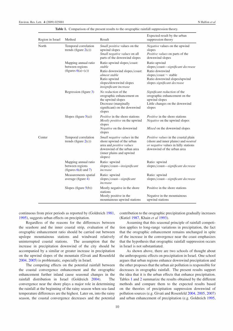
Table 1. Comparison of the present results to the orographic rainfall suppression theory.
Region in Israel Method ResultExpected result by the urbansuppression theory
North Temporal correlationtrends (figure 2(c))
Small positive values on theupwind slopesSmall negative values on allparts of the downwind slopes
Negative values on the upwindslopesPositive values on parts of thedownwind slopes
Mapping annual ratiobetween regions(figures 6(a)–(c))
Ratio upwind slopes/coast:stable
Ratio upwindslopes/coast—significant decrease
Ratio downwind slopes/coast:almost stable
Ratio downwindslopes/coast ∼ stable
Ratio upwindslopes/downwind slopesinsignificant increase
Ratio downwind slopes/upwindslopes significant decrease
Regression (figure 3) No reduction of theorographic enhancement onthe upwind slopesDecrease (marginallysignificant) on the downwindslopes
Significant reduction of theorographic enhancement on theupwind slopesLittle changes on the downwindslopes
Slopes (figure 5(a)) Positive in the shore stationsMostly positive on the upwindslopes
Positive in the shore stationsNegative on the upwind slopes
Negative on the downwindslopes
Mixed on the downwind slopes
Center Temporal correlationtrends (figure 2(c))
Small negative values in theshore upwind of the urbanarea and positive valuesdownwind of the urban area(inner plains and upwindslopes)
Positive values in the coastal plain(shore and inner plains) and neutralor negative values in hilly stationsdownwind of the urban area
Mapping annual ratiobetween regions(figures 6(d) and 7)
Ratio: upwindslopes/coast—insignificantincrease
Ratio: upwindslopes/coast—significant decrease
Measurements spatialaverage (figure 4)
Ratio: upwindslopes/coast—significantincrease
Ratio: upwindslopes/coast—significant decrease
Slopes (figure 5(b)) Mostly negative in the shorestations
Positive in the shore stations
Mostly positive in themountainous upwind stations
Negative in the mountainousupwind stations
continuous from prior periods as reported by (Goldreich 1981,1995), suggests urban effects on precipitation.
Regardless of the reasons for the differences betweenthe seashore and the inner coastal strip, evaluation of theorographic enhancement ratio should be carried out betweenupslope mountainous stations and windward relativelyuninterrupted coastal stations. The assumption that theincrease in precipitation downwind of the city should beaccompanied by a similar or greater increase in precipitationon the upwind slopes of the mountain (Givati and Rosenfeld2004, 2005) is problematic, especially in Israel.
The competing effects on the potential rainfall betweenthe coastal convergence enhancement and the orographicenhancement further inland cause seasonal changes in therainfall distribution in Israel (Goldreich 2004). Theconvergence near the shore plays a major role in determiningthe rainfall at the beginning of the rainy season when sea–landtemperature differences are the highest. Later on, into the rainyseason, the coastal convergence decreases and the potential
contribution to the orographic precipitation gradually increases(Kutiel 1987, Khain et al 1993).
Assuming that this seasonal principle of rainfall competi-tion applies to long-range variations in precipitation, the factthat the orographic enhancement remains unchanged in spiteof the increase in the convergence near the coast emphasizesthat the hypothesis that orographic rainfall suppression occursin Israel is not substantiated.
As shown above, there are two schools of thought aboutthe anthropogenic effects on precipitation in Israel. One schoolargues that urban regions enhance downwind precipitation andthe other proposes that the urban air pollution is responsible fordecreases in orographic rainfall. The present results supportthe idea that it is the urban effects that enhance precipitation.Tables 1 and 2 summarize the results obtained by the differentmethods and compare them to the expected results basedon the theories of precipitation suppression downwind ofpollution sources (e.g. Givati and Rosenfeld 2004, 2005, 2007)and urban enhancement of precipitation (e.g. Goldreich 1995,
10
Environ. Res. Lett. 4 (2009) 025001 N Halfon et al
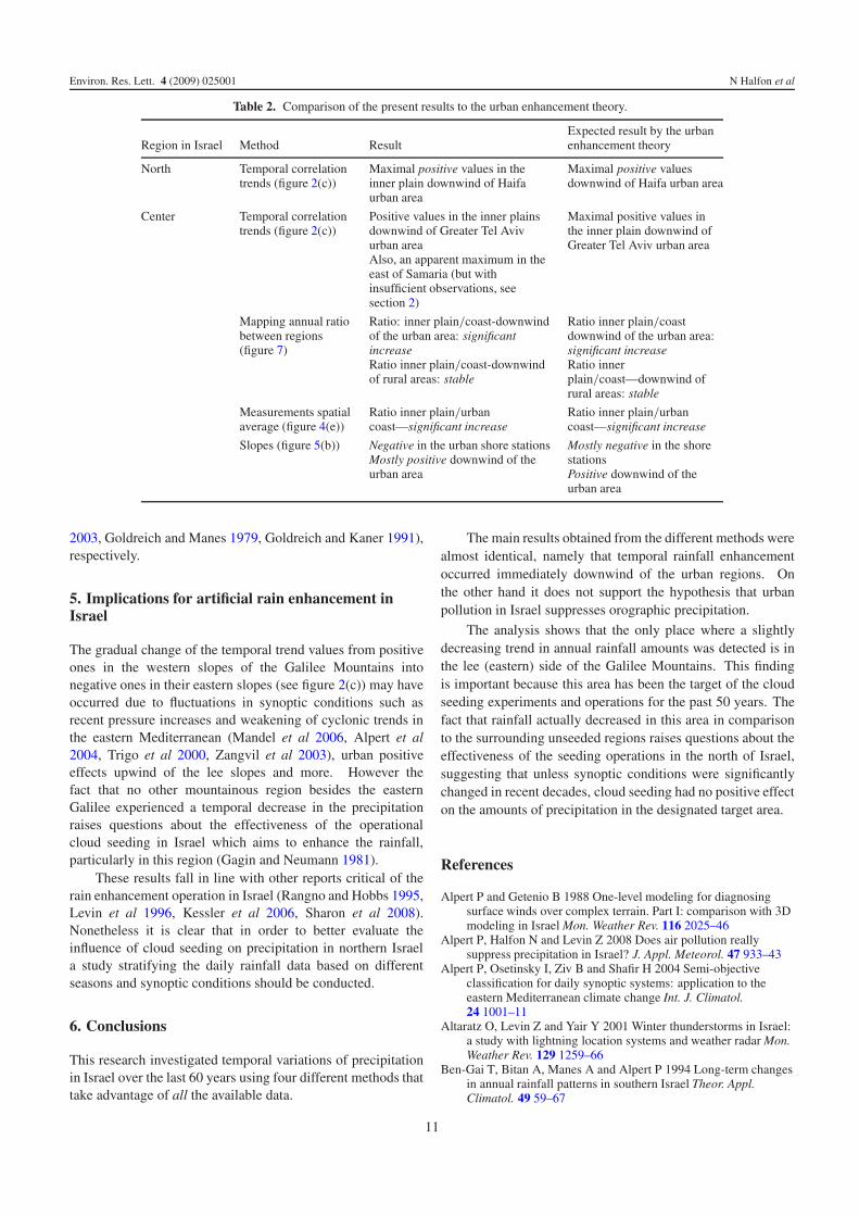
Table 2. Comparison of the present results to the urban enhancement theory.
Region in Israel Method ResultExpected result by the urbanenhancement theory
North Temporal correlationtrends (figure 2(c))
Maximal positive values in theinner plain downwind of Haifaurban area
Maximal positive valuesdownwind of Haifa urban area
Center Temporal correlationtrends (figure 2(c))
Positive values in the inner plainsdownwind of Greater Tel Avivurban areaAlso, an apparent maximum in theeast of Samaria (but withinsufficient observations, seesection 2)
Maximal positive values inthe inner plain downwind ofGreater Tel Aviv urban area
Mapping annual ratiobetween regions(figure 7)
Ratio: inner plain/coast-downwindof the urban area: significantincreaseRatio inner plain/coast-downwindof rural areas: stable
Ratio inner plain/coastdownwind of the urban area:significant increaseRatio innerplain/coast—downwind ofrural areas: stable
Measurements spatialaverage (figure 4(e))
Ratio inner plain/urbancoast—significant increase
Ratio inner plain/urbancoast—significant increase
Slopes (figure 5(b)) Negative in the urban shore stationsMostly positive downwind of theurban area
Mostly negative in the shorestationsPositive downwind of theurban area
2003, Goldreich and Manes 1979, Goldreich and Kaner 1991),respectively.
5. Implications for artificial rain enhancement inIsrael
The gradual change of the temporal trend values from positiveones in the western slopes of the Galilee Mountains intonegative ones in their eastern slopes (see figure 2(c)) may haveoccurred due to fluctuations in synoptic conditions such asrecent pressure increases and weakening of cyclonic trends inthe eastern Mediterranean (Mandel et al 2006, Alpert et al2004, Trigo et al 2000, Zangvil et al 2003), urban positiveeffects upwind of the lee slopes and more. However thefact that no other mountainous region besides the easternGalilee experienced a temporal decrease in the precipitationraises questions about the effectiveness of the operationalcloud seeding in Israel which aims to enhance the rainfall,particularly in this region (Gagin and Neumann 1981).
These results fall in line with other reports critical of therain enhancement operation in Israel (Rangno and Hobbs 1995,Levin et al 1996, Kessler et al 2006, Sharon et al 2008).Nonetheless it is clear that in order to better evaluate theinfluence of cloud seeding on precipitation in northern Israela study stratifying the daily rainfall data based on differentseasons and synoptic conditions should be conducted.
6. Conclusions
This research investigated temporal variations of precipitationin Israel over the last 60 years using four different methods thattake advantage of all the available data.
The main results obtained from the different methods werealmost identical, namely that temporal rainfall enhancementoccurred immediately downwind of the urban regions. Onthe other hand it does not support the hypothesis that urbanpollution in Israel suppresses orographic precipitation.
The analysis shows that the only place where a slightlydecreasing trend in annual rainfall amounts was detected is inthe lee (eastern) side of the Galilee Mountains. This findingis important because this area has been the target of the cloudseeding experiments and operations for the past 50 years. Thefact that rainfall actually decreased in this area in comparisonto the surrounding unseeded regions raises questions about theeffectiveness of the seeding operations in the north of Israel,suggesting that unless synoptic conditions were significantlychanged in recent decades, cloud seeding had no positive effecton the amounts of precipitation in the designated target area.
References
Alpert P and Getenio B 1988 One-level modeling for diagnosingsurface winds over complex terrain. Part I: comparison with 3Dmodeling in Israel Mon. Weather Rev. 116 2025–46
Alpert P, Halfon N and Levin Z 2008 Does air pollution reallysuppress precipitation in Israel? J. Appl. Meteorol. 47 933–43
Alpert P, Osetinsky I, Ziv B and Shafir H 2004 Semi-objectiveclassification for daily synoptic systems: application to theeastern Mediterranean climate change Int. J. Climatol.24 1001–11
Altaratz O, Levin Z and Yair Y 2001 Winter thunderstorms in Israel:a study with lightning location systems and weather radar Mon.Weather Rev. 129 1259–66
Ben-Gai T, Bitan A, Manes A and Alpert P 1994 Long-term changesin annual rainfall patterns in southern Israel Theor. Appl.Climatol. 49 59–67
11
Environ. Res. Lett. 4 (2009) 025001 N Halfon et al
Ben-Gai T, Bitan A, Manes A, Alpert P and Rubin S 1998 Spatialand temporal changes in rainfall frequency distribution patternsin Israel Theor. Appl. Climatol. 61 177–90
Changnon S A, Huff F A, Schickedanz P T and Vogel J L 1977Summary of METROMEX, vol I: weather anomalies andimpacts Illinois State Water Survey Bull. 62 264 pp
Changnon S A, Semonin R G, Auer A H, Braham R R and Hales J M1981 METROMEX: A Review and Summary (MeteorologicalMonograph vol 40) (Boston: American Meteorological Society)p 181
Changnon S A, Semonin R G and Huff F A 1976 A hypothesis forurban rainfall anomalies J. Appl. Meteorol. 15 544–60
ESRI Inc. 2004 ArcMap™9.0 Environmental Systems ResearchInstitute Inc., Redlands, CA
Gagin A and Neumann J 1981 The second Israeli randomized cloudseeding experiment: evaluation of the results J. Appl. Meteorol.20 1301–11
Givati A and Rosenfeld D 2004 Quantifying precipitationsuppression due to air pollution J. Appl. Meteorol. 43 1038–56
Givati A and Rosenfeld D 2005 Separation between cloud seedingand air pollution effects J. Appl. Meteorol. 44 1298–314
Givati A and Rosenfeld D 2007 Possible impacts of anthropogenicaerosols on water resources of the Jordan River and the Sea ofGalilee Water Resources Res. 43 W10419
Givati A and Rosenfeld D 2009 A comment on ‘Does air pollutionreally suppress precipitation in Israel?’ J. Appl. Meteorol. 48 atpress
Goldreich Y 1981 The urban effect as an additional factordetermining rainfall spatial distribution in Israel Isr. Meteorol.Res. Pap. 3 193–202
Goldreich Y 1990 The 1961–1990 rainfall normals, their annualmarch and relevance to the urban climate in Israel Isr. J. EarthSci. 39 85–92
Goldreich Y 1994 The spatial distribution of annual rainfall inIsrael—a review Theor. Appl. Climatol. 50 45–59
Goldreich Y 1995 Urban climate studies in Israel—a review Atmos.Environ. 29 467–78
Goldreich Y 2003 The Climate of Israel. Observation, Research andApplications (New York: Kluwer Academic/Plenum) p 298
Goldreich Y 2004 Spatial distribution of mid-season rainfall date inIsrael—a review Horiz. Geogr. 60/61 177–82
Goldreich Y and Kaner M 1991 Advertent/inadvertent effect on‘Rainfall Center’ displacement in the Northern Israel Atmos.Environ. B 25 301–9
Goldreich Y and Manes A 1979 Urban effect on precipitationpatterns in the Greater Tel-Aviv area Arch. Meteorol. Geophys.Bioclimatol. B 27 213–24
Goldreich Y, Moses H and Rosenfeld D 2004 Radar analysis ofcloud systems and their rainfall yield in Israel Isr. J. Earth Sci.53 63–76
Halfon N and Kutiel H 2004 Precipitation mapping in a mountainoustopography: the case of northern Israel Horiz. Geogr. 62 33–49(in Hebrew—English abstract)
Hindman E E, Hobbs P V and Radke L F 1977 Cloud condensationfrom a paper mill. Part II: calculated effects on rainfall J. Appl.Meteorol. 16 753–5
Hjemfelt M R 1982 Numerical simulation of the effects of St Louison mesoscale boundary-layer airflow and vertical air motion:simulations of urban versus non-urban effects J. Appl. Meteorol.21 1239–57
Hobbs P V, Radke L F and Shumway S E 1970 Cloud condensationnuclei from industrial sources and their apparent influence onprecipitation in Washington State J. Atmos. Sci. 27 81–9
Huff F A 1977 Urban effects on storm rainfall in Midwestern UnitedStates Proc. Amsterdam Symp., IAHS-AISH 123 pp 12–9
Kessler A, Cohen A and Sharon D 2006 Assessment of the effect ofoperational cloud seeding in northern Israel Abstract (inEnglish) of the Full Report Entitled: Analysis of the Cloud
Seeding Effectiveness in Northern Israel, Report to the IsraeliWater Authority, Environmental & Water Resources Eng. (2006)(Haifa) p 117 (in Hebrew)
Khain A P, Rosenfeld D and Sednev I 1993 Coastal effects in theeastern Mediterranean as seen from experiments using a cloudensemble model with detailed description and ice microphysicalprocesses Atmos. Res. 30 295–319
Khain A P, Sednev I and Khvorostyanov V 1996 Simulation ofcoastal circulation in the eastern Mediterranean using a spectralmicrophysics cloud ensemble model J. Clim. 9 3298–316
Krichak S O, Kishcha P and Alpert P 2002 Decadal trends of mainEurasian oscillations and the eastern Mediterraneanprecipitation Theor. Appl. Climatol. 72 2002–20
Kutiel H 1987 Rainfall variations in the Galilee (Israel).I—variations in the spatial distribution in the periods1931–1960 and 1951–1980 J. Hydrol. 94 331–44
Levin Z, Ganor E and Gladstein V 1996 The effects of desertparticles coated with sulfate on rain formation in the easternMediterranean J. Appl. Meteorol. 35 1511–23
Mandel M, Alpert P and Osetinsky I 2006 Assessing the easternMediterranean mesoscale circulation by clustering the dailyweather The Annual Mtg of Israel Meteorological Society (TelAviv, March 2006) p 5 (Available at: http://ims.huji.ac.il/abstracts2006/MosheMandel1.pdf)
Rangno A L and Hobbs P V 1995 A new look at the Israeli cloudseeding experiments J. Appl. Meteorol. 34 1169–93
Rosenfeld D 1986 The dynamic characteristics of cumuliform cloudsand cloud systems and their effect on the rainfall precipitated bythem A Thesis Submitted for the Degree Doctor of PhilosophyHebrew University in Jerusalem, Jerusalem, p 143
Shafir H and Alpert P 1990 On the urban orographic rainfall anomalyin Jerusalem—a numerical study Atmos. Environ. B 24 365–75
Sharon D, Kessler A and Cohen A 2008 The history and recentrevision of Israel’s cloud seeding program Isr. J. Earth Sci.57 65–9
Sharon D and Kutiel H 1986 The distribution of rainfall intensity inIsrael, its regional and seasonal variations and its climatologicalevaluation J. Climatol. 6 277–91
Shepherd J M and Burian S J 2003 Detection of urban-inducedrainfall anomalies in a major coastal city Earth Interact. 7 4
Shepherd J M, Pierce H F and Negri A J 2002 Rainfall modificationby major urban areas: observations from spaceborne rain radaron the TRMM satellite J. Appl. Meteorol. 41 689–701
Steinberger E H and Gazit-Yaari N 1996 Recent changes in thespatial distribution of annual precipitation in Israel J. Clim.9 3328–36
Thielen J, Wobrock W, Gadian A, Mestayer P G and Creutin J D2000 The possible influence of urban surfaces on rainfalldevelopment: a sensitivity study in 2D in the meso-gamma scaleAtmos. Res. 54 15–39
Trigo I F, Davies T D and Bigg G R 2000 Decline in Mediterraneanrainfall caused by weakening of Mediterranean cyclonesGeophys. Res. Lett. 27 2913–6
Warner J 1968 A reduction in rainfall associated with smoke fromsugar-cane fires—an inadvertent weather modification J. Appl.Meteorol. 7 247–51
Warner J 1971 Smoke from sugar-cane fires and rainfall Proc. Int.Conf. on Weather Modification (Canberra: AmericanMeteorological Society) pp 191–2
Warner J and Twomey S 1967 The production of cloud nuclei bycane fires and the effect on cloud droplet concentration J. Appl.Meteorol. 24 704–6
Zangvil A, Karas S and Sasson A 2003 Connection between easternMediterranean seasonal mean 500 hPa height and sea-levelpressure patterns and the spatial rainfall distribution over IsraelInt. J. Climatol. 23 1567–76
12