ten years of mapping and monitoring intact forest
TRANSCRIPT

Ten Years of Mapping and Monitoring Intact Ten Years of Mapping and Monitoring Intact Forest Landscapes in the TropicsForest Landscapes in the Tropics
Ilona ZhuravlevaGreenpeace Russia
2011
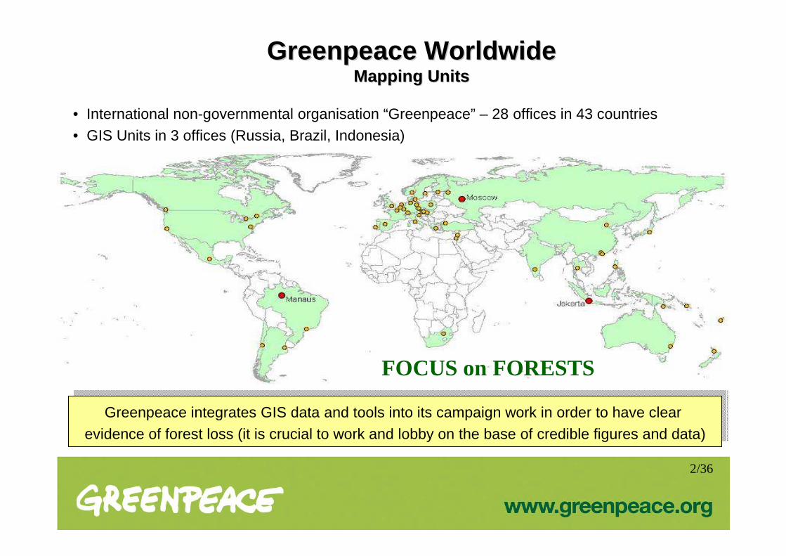
Greenpeace WorldwideGreenpeace WorldwideMapping UnitsMapping Units
• International non-governmental organisation “Greenpeace” – 28 offices in 43 countries• GIS Units in 3 offices (Russia, Brazil, Indonesia)
FOCUS on FORESTS
2/36
Greenpeace integrates GIS data and tools into its campaign work in order to have clear
evidence of forest loss (it is crucial to work and lobby on the base of credible figures and data)Greenpeace integrates GIS data and tools into its campaign work in order to have clear
evidence of forest loss (it is crucial to work and lobby on the base of credible figures and data)

Forests of the World Forests of the World
Vegetation Continuous Fields, 2000(Global 500m Tree Cover Product from MODIS)
Starting Point in 2000
3/36

Why are Large Intact Forests Important ?Why are Large Intact Forests Important ?
The United Nation’s Convention on Biological Diversity (CBD) has realised the importance of large intact forests and other intact ecosystems (see, e.g. Tech Series 41). In the UN Framework Convention on Climate Change (UNFCCC) discussions on Reducing Deforestation and Degradation in developing countries (REDD), emerges the importance of preserving natural forests and IFLs are the backbone of the world’s natural forests.
“In largely intact forest landscapes where there is currently little deforestation and degradation occurring, the conservation of existing forests, especially primary forests, is critical both for preventing future greenhouse gas emissions through loss of carbon stocks and
ensuring continued sequestration, and for conserving biodiversity.”- (CBD 2009)
- Better recovering from disturbances (resistance and resilience)
- Important for the preservation of all strata of biological diversity (especially for large animals)
- Maintaining ecological processes and supplying ecos ystem services like water and air purification, nutrient cycling, carbon sequestration, erosion, and flood control
- High conservation value + low economic value = easy to protect
4/36

Intact Forest Landscape (IFL)
An unbroken expanse of natural ecosystems within the zone of current forest extent, showing no signs of significant human activity and large enough that all native biodiversity, including viable populations of wide-ranging species, could be maintained.
IFL DefinitionIFL Definition
Source: Potapov, P., A. Yaroshenko, S. Turubanova, M. Dubinin, L. Laestadius, C. Thies, D. Aksenov, A. Egorov, Y. Yesipova, I. Glushkov, M. Karpachevskiy, A. Kostikova, A. Manisha, E. Tsybikova, and I.Zhuravleva. 2008. Mapping the world’s intact forest landscapes by remote sensing. Ecology and Society 13(2): 51. [online] URL: http://www.ecologyandsociety.org/vol13/iss2/art51/
5/36

IFL Size CriteriaIFL Size Criteria
Areas within today's global extent of forest cover which contains forest and non-forest ecosystems minimally influenced by human economic activity:
• Larger than 50,000 ha
• At least 10 km wide at the broadest place (measured as the diameter of the largest circle that can be fitted inside the patch)
• At least 2 km wide in corridors or appendages to areas that meet the above criteria
Indonesia, Riau province. 2010Landsat-7 ETM+ slc-off,
6/36

Disturbed Areas Exclusion AlgorithmDisturbed Areas Exclusion Algorithm
* Basis: Vegetation Continuous Fields, 2000(Global 500m Tree Cover Product from MODIS)
>40%, close forests20-40%, open forests
Forests, Tree canopy density*
Forest zone
Forest zone: all forests with tree canopy density greater than 20% if the distance between them is less than 2 km and all non-forest plots which are fully surrounded by forests. Fragments of the forest zone smaller than 50,000ha were not considered in the analysis
Small fragments
Patches larger then 50,000 haUSA, 2000TIGER dataset,
Scale 1 : 100 000
“Negative” approach . Exclusion of deforested areas and small fragmented patches based on infrastructure maps
Step 1. Forest Zone Step 1. Forest Zone DefiningDefining
Step 2.Step 2. DDeveloped Areaseveloped AreasAnalysisAnalysis
7/36

“Inverse" logic. Checking large forested areas for indications of active or recent use (clearing for agriculture, logging, and infrastructure development) based on satellite images
Disturbed Areas Exclusion AlgorithmDisturbed Areas Exclusion AlgorithmStep 3. Step 3. FragmentationFragmentation Analysis Analysis
What was excluded:
- Populated places
- Infrastructure line objects (buffer of 1km on each side was applied): roads, railways, navigable waterways,
seashore, pipelines and power transmission lines
- Areas used for agriculture and timber production
- Areas affected by industrial activities during the last 30-70 years (logging, mining, oil and gas, peat exploration, etc)
Yellow line – IFL border
Indonesia. 2005Landsat-7 ETM+
IFL IFL
Logging Navigate River
Yellow line – IFL border
Republic of the Congo. 2010Mosaic of Landsat-7 ETM+ slc-off
8/36

History of IFL MappingHistory of IFL Mapping
IFLs of North European part of Russia (2001)
IFLs of Russia(2002)
Boreal IFLs of Russia, Canada,
USA, Sweden, Finland, north parts of Japan
and China(2003)
9/36

The WorldThe World ’’s IFLss IFLs (200(20066)).. Key FindingsKey Findings
• IFLs exist in 66 of the 149 countries within the forest zone. Most of IFLs (90%) occur in 13 countries , and three of them – Canada, Russia and Brazil – contain 63.8% of the world's entire IFL area
• Less then 19% of IFLs have some form of protection, 9.7% – are strictly protected (according to IUCN categories I-III of protected areas). The protection percentage is the highest for Temperate forests and lowest for Boreal forests (less than 4.4%). Comparing continents, the protection percentage is lowest in Asia . Some Asian countries – China, Cambodia, Laos, Vietnam – have placed little or none of their IFL area under protection
• IFL area – 13.1 million km 2 (23.5% of the forest zone)
• Most of the IFL consist of closed forests (64.5%), with the remainder spread over open forests and woodlands (20.5%), and non-forest ecosystems (15.0%)
• The vast majority of IFL – in two biomes: Humid Tropical and Boreal forests . The lowest proportion of IFLs – in Temperate forests
10/36

IFLs MonitoringIFLs Monitoring
…TropicsTropics Non-boreal EuropeNon-boreal Europe
Northern European Russia
Northern European Russia
IFLs in Northern European Russia, Russia, 2007
Country IFLs. Democratic Republic of the Congo, 2011
Retezat Nationla park, Retezat-Godeanu-Tarcu IFL, Romania, 2009
IFL fragmentation and degradation
11/36

World IFLs Monitoring World IFLs Monitoring –– Focus on TropicsFocus on Tropics
Congo Basin Paradise ForestsBrazilian Amazon Brazil Democratic republic of the Congo
Republic of CongoGabonCameroonCentral African RepublicEquatorial Guinea
IndonesiaPapua – New Guinea
19% 4%8%
12/36

Monitoring Focus on Tropics Monitoring Focus on Tropics -- ReasonsReasons
• 30% world IFLs in 9 tropical countries
• Humid tropical biome is one of two (the second is Boreal biome) where IFLs mostly are concentrated
• Tropical forests do have a higher biodiversity than other forests
• The lowest chance of survival where economies are predominantly based on export
• The highest rate of deforestation (Paradise forests)
• Deforestation of peatforests (Indonesia) is releasing a huge amount of carbon emissions
13/36

CCycle of IFL ycle of IFL DDestructionestruction
Fragmentation Degradation Deforestation
Roads Selective logging Agro-industrial clearing
14/36

Main Drivers of IFLs Degradation in TropicsMain Drivers of IFLs Degradation in Tropics
• Palm Oil Industry• Pulp & Paper Industry
• Industrial Logging• Upcoming Commercial
Plantations• Population Growth
• Soy Industry• Cattle Farming
Brazilian Amazon Congo Basin Paradise Forests
Lack of Governance, Transparency, Control and Monit oring; CorruptionWeak forest policies, laws and/or law enforcement
Export-oriented Economics
Lack of Governance, Transparency, Control and Monit oring; CorruptionWeak forest policies, laws and/or law enforcement
Export-oriented Economics
15/36

Monitoring ProcessMonitoring Process
200016/36

Monitoring ProcessMonitoring Process
200517/36

Monitoring ProcessMonitoring Process
201018/36

IFL Loss 2000-2005
IFL Loss 2005-2010
IFL Area 2010
Monitoring ProcessMonitoring Process
19/36

Current State of Tropical IFLsCurrent State of Tropical IFLs20102010
371,135 ha * 1000(equal ½ Australia)
BrazilianAmazon
63%
CongoBasin
24%
ParadiseForests
13%

Tropical IFLs Loss 2000/2005/2010Tropical IFLs Loss 2000/2005/2010% IFL change
2000-2005% IFL change
2005-2010IFL change
trend% IFL change
2000-2010
TOTAL TROPICS 4.0 2.0 2 5.9
Brazil (Amazon) 4.1 1.1 3 ¾ 5.2
Congo Basin 3.5 2.0 1 ¾ 5.5
Paradise forests 4.9 5.7 1 ½ 10.4
Ha*10002
395,000 371,000379,000
24,000 ha*1000 (≥ Israel area)
IFL loss in absolute areas 2000-2010
21/36

22/36
IFL Change Proportions inIFL Change Proportions in 20002000--20102010
15%31%
27%
24%
2% 1%Republic of the Congo
Gabon
Democratic Republic of the Congo
Cameroon
Central African Republic
Equatorial Guinea
100%
Brasilia (Amazon)
33%
67%
Indonesia
Papua New Guinea
Brazil (Amazon)Congo Basin Paradise Forests
54%22%
24%
Brazil(Amazon) Congo
Basin
Paradise Forests• More then half of all IFL
change occurred in Brazil (Amazon)
• Paradise Forests and Congo basin lost approximately one and the same IFL area –quarter of all IFL changes
• More then 80% of all change in Congo Basin is located in 3 countries (Republic of the Congo, Gabon, Democratic Republic of the Congo)
• Approximately 70% of all changes in the Paradise Forests are located in Indonesia - the other 30 % are located in Papua New Guinea

IFL IFL Loss Rates Loss Rates –– Country AnalysisCountry Analysis
- Countries with more then 10% IFL loss during 2000-2010
23/36
Brazil (Amazon) 4.1 1.1 3 ¾ 5.2
Democratic Republic of Congo 1.0 0.9 = 1 1.9
Republic of Congo 8.4 3.3 2 ½ 11.4
Gabon 8.7 4.8 1 ¾ 13.1
Cameroon 10.2 5.2 2 14.9
Central African Republic 2.4 12.4 5 14.5
Equatorial Guinea 11.7 2.5 4 ¾ 13.9
Indonesia 4.3 5.9 1 ¼ 10.0
Papua-New Guinea 6.4 5.3 1 ¼ 11.4
% IFL loss2000-2005
% IFL loss2005-2010
IFL ChangeTrend
% IFL loss2000-2010

IFL Loss in Tropics: Brazilian AmazonIFL Loss in Tropics: Brazilian Amazon
- IFL loss (deforestation or degradation) in 2000-2005
- IFL loss (deforestation or degradation) in 2005-2010
- IFL area 2010
BRASIL24/36

IFL Loss in the Tropics: Paradise ForestsIFL Loss in the Tropics: Paradise Forests
INDONESIA
- IFL loss (deforestation or degradation) in 2000-2005
- IFL loss (deforestation or degradation) in 2005-2010
- IFL area 2010
PAPUA NEW GUINEA
25/36
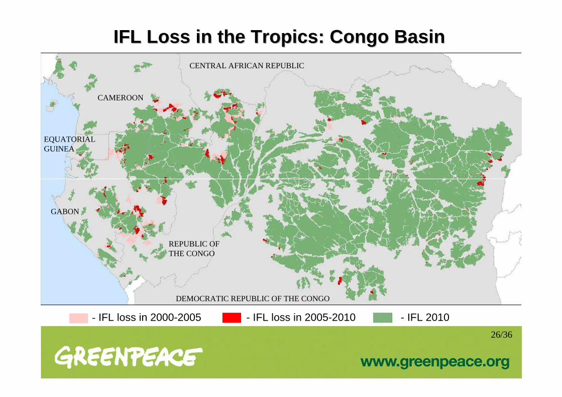
IFL Loss in the Tropics: Congo BasinIFL Loss in the Tropics: Congo Basin
DEMOCRATIC REPUBLIC OF THE CONGO
- IFL loss in 2000-2005 - IFL loss in 2005-2010 - IFL 2010
REPUBLIC OF THE CONGO
EQUATORIAL GUINEA
CAMEROON
CENTRAL AFRICAN REPUBLIC
GABON
26/36

IFL loss in the Tropics: Paradise ForestsIFL loss in the Tropics: Paradise ForestsCase study Case study –– province analysis in Paradise Forests, 2000province analysis in Paradise Forests, 2000 --20052005
Indonesia Papua New Guinea
- In 3 provinces of Indonesia (Maluku Utara, Riau, Sumatera Utara) and 2 provinces of Papua New Guinea (Gulf, West New Britain), the rate of IFL loss (deforestation and degradation) in 2000-2005 is higher than 10%
% of IFL change in 2000-2005 in Provinces
No changesLess then 1%1-5%5-10%10-20%More then 20%
27/36

IFL Mapping and Monitoring Implementation: IFL Mapping and Monitoring Implementation: The Forest Stewardship Council (FSC) Certification ProcessThe Forest Stewardship Council (FSC) Certification Process
- The Definition of High Conservation Value Forest category 2 (HCVF2) used in Principles and Criteria for Forest Stewardship (FSC 2004) is similar to that of Intact Forest Landscapes. The Principles claim intactness values to be preserved as a condition for getting certified.
- In the FSC Controlled Wood standard (FSC 2006) IFL are directly mentioned among other categories of High Conservation Value Forests
- Some regional FSC standards like the Russian one incorporated IFLs (in addition to HCVF)
Canada. Agreement between 9 NGOs and Forest Products Association of Canada. 2010
Russia. Komi Republic. The scheme for NROs and “IlimSeverLes” agreement. 2008
Russia. Karelia Republic. Moratorium agreement between NRO “SPOK” and “Ledmozerskoe” timber company. 2009
28/36

IFL Loss in the Tropics: Congo BasinIFL Loss in the Tropics: Congo BasinCase Study Case Study -- IFLs and Industrial Logging Titles in Congo Basin C ountries, 20IFLs and Industrial Logging Titles in Congo Basin C ountries, 20 1010
Democratic Republic of the Congo
29/36

IFL Loss in the Tropics: Congo BasinIFL Loss in the Tropics: Congo BasinCase study Case study -- IFLs Losses and Industrial Logging Titles in IFLs Losses and Industrial Logging Titles in
the Democratic Republic of Congo, 2000the Democratic Republic of Congo, 2000 --20102010
No changesLess then 5%5-10%10-50%50-90%90-100%
No changesLess then 5%5-10%10-50%50-90%90-100%
Concession titlesIFLs outside of concessions
Change (2000-2010) per each IFL patch
Rate of loss of areas in IFLs (2000-2010) within concession title area
IFLs inside concession
30/36
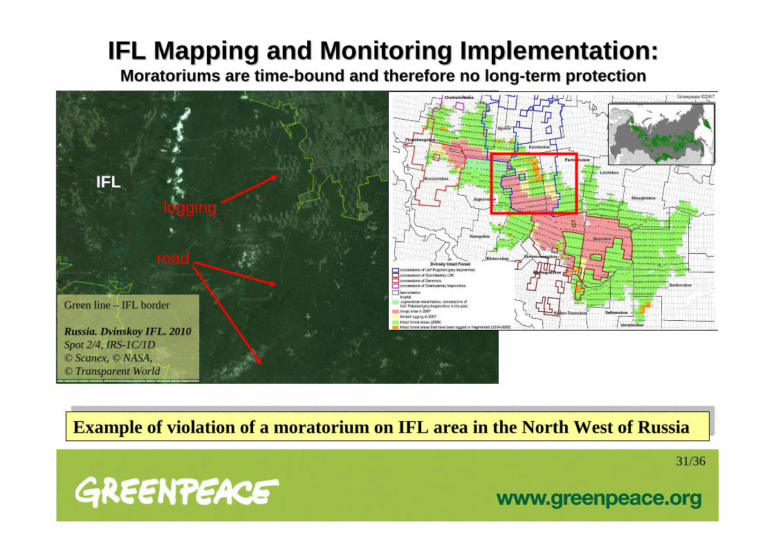
IFL Mapping and Monitoring Implementation: IFL Mapping and Monitoring Implementation: MoratoriumsMoratoriums are timeare time --bound and therefore no longbound and therefore no long --term protection term protection
Example of violation of a moratorium on IFL area in the North West of RussiaExample of violation of a moratorium on IFL area in the North West of Russia
road
logging
IFL
Green line – IFL border
Russia. Dvinskoy IFL. 2010Spot 2/4, IRS-1C/1D© Scanex, © NASA, © Transparent World
31/36

IFL Mapping and Monitoring Implementation: IFL Mapping and Monitoring Implementation: Protected Area exampleProtected Area example
National ParkUdegeiskaya Legenda
Example of IFL Conservation in the Far East of RussiaExample of IFL Conservation in the Far East of Russia
Green line – IFL borderRed line – National Park border
Russia. Primorsky kray. 2007Spot 2/4, IRS-1C/1D© Scanex, © NASA, © Transparent World
Half of National Park “Udegeiskaya Legenda” is IFL
The north part of the Park is given for local communities (the Udegheis) for forestry
Part given to the Udegheis
32/36

IFL Mapping and Monitoring Implementation: IFL Mapping and Monitoring Implementation: Protected Areas in TropicsProtected Areas in Tropics
• While the average figure of IFLs under strict protection* is 9.7%, the average figure in the
Tropics is lower, only 6.7%
• 11.5% of Paradise Forest’s, 8% of the Congo Basin’s, 5% of the Brazilian Amazon’s IFL
area are strictly protected
• Only 0.03% of Gabon IFLs are strictly protected. There are no Protected Areas in Papua
New Guinea
• The largest portion of IFL protected areas are in Equatorial Guinea – more then 40% of IFL
area are strictly protected; in Cameroon , Indonesia and Republic of the Congo , more
than 10% are protected
* IUCN categories I-III according to UNEP/IUCN World Database on Protected Areas (which in most countries doesn’t gurantee strict implementation on the ground)
33/36
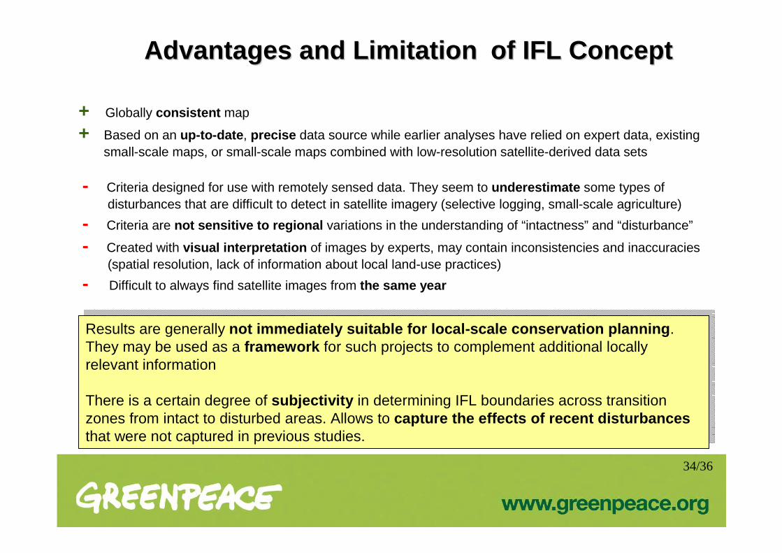
Advantages and Advantages and LimitationLimitation of IFL Conceptof IFL Concept
+ Globally consistent map
+ Based on an up-to-date , precise data source while earlier analyses have relied on expert data, existing small-scale maps, or small-scale maps combined with low-resolution satellite-derived data sets
- Criteria designed for use with remotely sensed data. They seem to underestimate some types of disturbances that are difficult to detect in satellite imagery (selective logging, small-scale agriculture)
- Criteria are not sensitive to regional variations in the understanding of “intactness” and “disturbance”
- Created with visual interpretation of images by experts, may contain inconsistencies and inaccuracies (spatial resolution, lack of information about local land-use practices)
- Difficult to always find satellite images from the same year
Results are generally not immediately suitable for local-scale conservati on planning . They may be used as a framework for such projects to complement additional locally relevant information
There is a certain degree of subjectivity in determining IFL boundaries across transition zones from intact to disturbed areas. Allows to capture the effects of recent disturbances that were not captured in previous studies.
34/36

• The concept is not known everywhere - how to better distribute it beyond Greenpeace channels?
• How to get IFL protection into legally binding policies and regulations at different levels (including appreciating and implementation IFL concept by international conventions and processes)?
• How to better integrate and use synergies with other conservation concepts?
• How to deal with the fact that the majority of remaining IFLs are situated in just a few countries and they’ll be against complete protection of them
Open Questions and DiscussionOpen Questions and Discussion
35/36

Ilona ZhuravlevaGIS Lab Head of Greenpeace Russia
[email protected]+7 (495) 988-74-60
Skype: zhilonaMoscow, Leningradskiy prospekt, 26, b.1
www.greenpeace.org www.intactforests.org
Thank you for attention!Thank you for attention!
36/36