terracing as a measure of soil erosion control and its effect on … · 2018-09-25 · farming...
TRANSCRIPT

14
Terracing as a Measure of Soil Erosion Control and Its Effect on Improvement
of Infiltration in Eroded Environment
Marcin K. Widomski Lublin University of Technology
Poland
1. Introduction
Soil erosion by water is commonly recognized as the one of main reasons of land degradation worldwide (e.g. Ananda & Herath, 2003; Beskow et al., 2009; Valentin et al., 2005). Most of the involved areas are occupied by various agricultural activities but pastures, forestry, unpaved roads as well as construction sites are also endangered by water erosion (Ananda & Herath, 2003; Arnanez et al., 2004; Harbor, 1999; Jungerius et al., 2002). Exemplary, in Europe, excluding European part of Russia, human-induced soil erosion develops on approximately 114 milion hectrares, which is 17 % of total land area (Gobin, 2004). According to information presented by Pimentel and Kounang (1998) more than 80% of world’s agricultural land suffers soil erosion, from moderate to severe level. The mean noted yearly soil erosion rate on cropland worldwide reaches the level of approx. 30 Mg ha-1, while reported values vary from 0.5 to over 400 Mg ha-1 yr-1 (Pimentel & Kounang, 1998). Soil erosion rates, caused by water, are highest in agrosystems located in hilly or mountainous regions of Asia, Africa and Southern America, especially in less developed countries. According to studies reported by Kuhlman et al. (2010) construction sites in Europe are endangered by soil erosion rate higher than 2.0 Mg ha-1 yr-1, while soil erosion rate noted on approx. 70% of European arable lands is lower than 0.5 Mg ha-1 yr-1 or ranges from 0.5 to 2.0 Mg ha-1 yr-1. Several factors influencing the rate of soil erosion by water were reported (e.g. Amore et al. 2004; Askoy and Kavvas, 2005; Basic et al., 2004; Zhang et al., 2008): - Climatic conditions: precipitation, frequency of extreme rainfall events and thickness of
snow cover as well as rate of its melting; - Terrain surface morphology determining the rate of surface runoff generation and flow
velocity: hillside slopes’ length, inclination and exposure; - Soil characteristics: its particle size composition and erodibility; - Soil usage: manner of agricultural, forestry, engineering or constructional activities. Soil erodibility is understood as a measure of its susceptibility to detachment and transport by water (Hammad et al., 2006). Among soil characteristics several properties influencing erodibility may be determined: aggregate stability, organic matter and clay particles content. Various types of soil erosion may be triggered by rainfall, thaw and runoff water: sheet, rill, and gully erosion (Askoy & Kavvas, 2005; Grønsten & Lundekvam, 2006; Valentin et al.,
www.intechopen.com

Soil Erosion Issues in Agriculture 316
2005). Sheet erosion occurs when detached by impact of rain drop approximately uniform layer of soil particles is being transported downslope in unconcententrated flow, as a sheet. Rill and gully erosion are triggered by small concentrated flows along initially ephemeral rills or channels, which may, in time, involving higher rates of concentrated surface flows, develop larger morphological forms, even, in addition to soil crusts, slope inclination and tunneling creating erosional gullies (e.g. Askoy & Kavvas, 2005; Valentin et al., 2005). Thus, soil erosion by water may trigger various negative changes in soil cover of eroded basin. According to literature reports, these effects of soil erosion may be divided into several main groups: changes in mechanical and mineral compositions of soil, changes and transformations of ground surface morphology, amendments in water balance of eroded catchments and reduction of soils’ fertility (e.g. Fullen et al., 1998; Lado & Ben-Hur, 2004; Pimentel & Kounang, 1998; Valentin et al., 2005; Widomski et al., 2010; Widomski & Sobczuk, 2007). The reported changes in mechanical and mineral compositions of soils are reflected by decreased content of organic matter and alerted content of all soil fractions (i.e. removal of clay fraction and increase of coarse ones), which in turn may be reflected in decreased water permeability and water capacity of eroded slope and increased volume of generated surface runoff. The volume of infiltration rate of surface water into deeper layers in the eroded profile may be reduced. Thus, the water balance of eroded basin may be significantly changed, generally shortened - the resultant water balance of eroded catchment usually presents reduced inflow of water into underground aquifer, thus limiting water availability for plants (Valentin et al., 2005; Widomski et al., 2010). Increased run-off may also result in increased removal of nutrients form top layer of soil, thinning and even, partial or complete, removal of top soil layer. The noticeable site effects of soil erosion such as rills and erosional gullies together with changes in soils fertility and water-storage capacity may drastically reduce its agricultural or forestry productivity. Removal of erosion effects covering repairing works, workload and materials is often costly (e.g. Kuhlman et al. 2010; Valentin et al., 2005). Therefore, the development and practical application of soil erosion control systems is obvious. Literature reports show that soil erosion control system should (e.g. Govers et al., 2004; Nyssen et al., 2004; Valentin et al., 2005): - Reduce destructive processes occurring in top soil; - Improve infiltration of surface water into soil profile, thus improving water balance of
eroded basins and increasing the amount of water available to plants; - Limit the soil fertility deterioration caused by soils’ composition changes and removal
of nutrients and organic matter from soil. Many techniques of soil conservation and erosion control have been developed in agricultural areas, starting from various types of soil tillage and vegetation cover (Basic et al., 2004; Cerdan et al., 2002; Robinson, 1999; Zheng, 2006), to different types of terraces, check dams and stone bunds (e.g. Govers et al., 2004; Valentin et al., 2005). This chapter covers presentation of terracing as a method of soil erosion control and its efficiency assessment based on literature reports and numerical prediction of soil erosion rate for non-terraced and terraced system. The effects of various types of terraces on soil moisture and infiltration rate were also discussed. Special attention was paid to numerical modeling of infiltration rate for terraces-based system of erosion control on steep slopes developed and tested in Olszanka, Poland, where improvement of infiltration was secured by additional drainage elements filled with sand.
www.intechopen.com

Terracing as a Measure of Soil Erosion Control and Its Effect on Improvement of Infiltration in Eroded Environment 317
2. Terracing – types and brief description
Terracing is an agricultural technique for collecting surface runoff water thus increasing infiltration and controlling water erosion known from an ancient history and used to transform landscape to steeped agrosystems in many hilly or mountainous regions of the world (Zuazo et al., 2005). The well known regions of frequent application of terraces in Europe cover Spain, Italy, France, Portugal, Hungary (basically for vineyard cultivation) but they are also employed in such countries like Norway and Poland (Cots-Folch et al.,2006; Widomski et al. 2010). Terracing is also commonly used in agriculture in Northern and Southern America, Asia (e.g. Chinese Loess Plateau, Thailand, India etc.) and in developing countries in arid environment in Africa, i.e. Ethiopia, Rwanda, Tanzania and others (e.g. Dabney et al., 1999; Fu et al., 2003; Nyssen et al., 2000; Ramos et al., 2007; Sang-Arun et al., 2006; Tenge et al. 2005). Terraces are usually used to cultivate, manually or with mechanization application, different plants – from grains to grapes and various fruit trees e.g. apples, avocado, mango, loquat, litchi and others (Zuazo et al., 2005). The main purpose of terracing application was to improve the usefulness of steep slope and to increase its agricultural potential. This function is realized by creating the level surfaces according to contour lines of transformed slope (Cots-Folch et al., 2006). The level, bench platform allows to spread the surface runoff water, decreases its speed and thus allows more time for water infiltration into soil profile. Terraces are usually reported as a successful soil erosion control manner in regions endangered by soil erosion by combinations of steep slopes, climatic conditions and erodible soils. But in some cases this effectiveness is limited, especially with combination of sparse vegetation (Zuazo et al., 2005). They are also, in some cases, found to be expensive to construct and maintain (Ramos et al., 2007). The main, worldwide known types of terraces are: various bench terraces, back-sloping bench terraces, stone-wall terraces and Fanya juu terraces (e.g. Tenge et al., 2005). Bench terraces (Fig. 1) usually consist of a series of level or nearly level platforms constructed along the contour lines of terraced slope (e.g. Ramos et al., 2007; Tenge et al., 2005.) Platforms are separated by embankments known as risers. The main task of level platforms (also known as benches) is to reduce the length of the slope and its steepness, so the amount and velocity of surface runoff is also being reduced and the nearly level platforms retain surface water and allow infiltration into top soils. Thus the erosion control and increased infiltration of rain water as well as limiting soil fertility loss are possible. Bench terraces also allow mechanized farming operations and improvement water management (irrigation). The main observed disadvantages are construction and maintenance costs as well as observed reduction of cropping area (Ramos et al., 2007).
Fig. 1. Scheme of typical bench terraces
www.intechopen.com

Soil Erosion Issues in Agriculture 318
Generally bench terraces may be used on slopes up to 55% steep, with deep slopes and stable soils (landslides risk). Ramos et al. (2007) give more precise construction limits for lad slope – circa 20° for terraces constructed by machinery and 25° for terraces build by hand. Benches usually have width of 2,5-5 m for handmade and 3-8 m for terraces constructed by machinery, and slope gradient of the riser should be equal to 0.75:1 or 1:1. Increase of infiltration rate on traditional bench terraces may be achieved by the additional infiltrational elements filled by permeable material e.g. sand (Widomski et al., 2010). The novel system of terracing increasing infiltration rate and improving the water balance of eroded catchment was developed by Rubaj (2002) on loess soils at fruit farm in Olszanka, Poland (Fig. 2). The system built on 6 to 15% upland slopes consists of terraces equipped with sand-filled ditches. Geometrical dimensions of constructed platforms are 4.0 m width, inclination downslope approx. 1% and 0.3 – 0.5 m of risers height, while sand filled ditches are 0.30 m wide and 0.80 m deep. Riser inclination is close to 70%. The level platform span was adjusted to the dimensions of tractors and other agricultural equipment used in farming operations. Draining ditches dimensions were determined by Rubaj (2002) based on estimations utilizing water capacity of sand filling and mean rainfall amounts contributed per precipitation event. Bench terraces in Olszanka are used to mechanically cultivate apple trees (Malus domestica Borkh) with platforms’ surface strengthen by cover of the natural mixture of grasses. Despite numerous reports presenting information that prolonged infiltration resulting in increased saturation of loess soils may trigger geotechnical slope instability (Derbyshire, 2001; Wang & Sassa, 2003; Zhao et al., 2000), installation of draining ditches at Olszanka has not altered slope stability in the treated area (Widomski et al., 2010).
Fig. 2. Scheme of bench terraces with sand-filled ditches
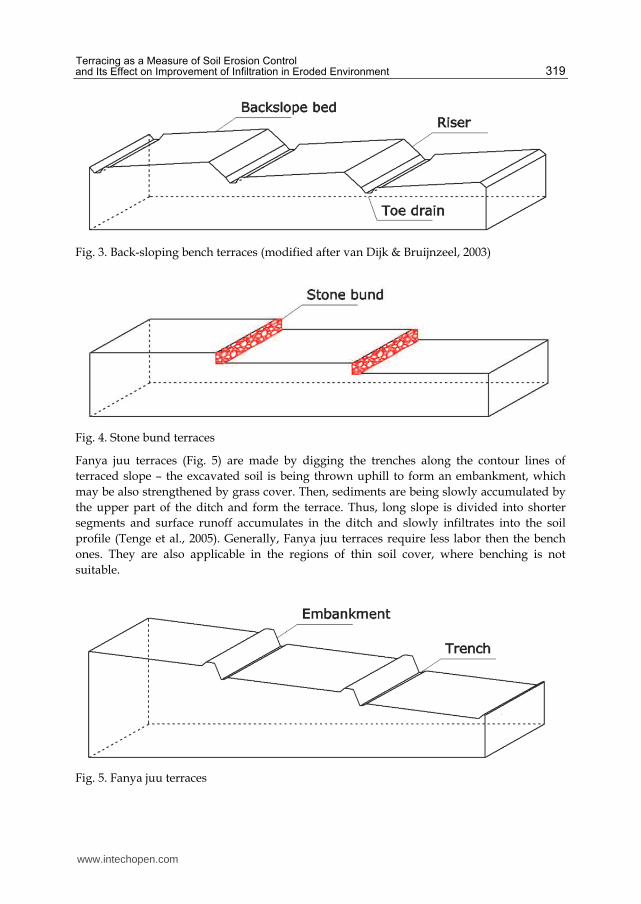
Back-sloping bench terraces, presented at Fig. 3, are consisting of a riser, a compacted toe drain, located close to the riser, and a bed sloped back towards the toe drain (van Dijk & Bruijnzeel, 2003). The reported terrace risers have slopes of 35-50°, with terrace bed reaching the back-slope of 12°. The toe drain of approx. width of 0.3-0.4 m is usually slightly inclined (1-3°) towards the end of the terrace. Thus, the surface runoff water is redirected – the parallel flow, through the central drain, parallel to the contour line of the slope is possible. This type of terracing is usually suggested for regions of heavy precipitation. Sone wall terraces (Fig. 4) are usually level or nearly level terraces based on stone walls (or stone bunds) reinforcing the risers. Stone walls or bunds are deployed along the slope. Then, with time, sediments deposition creates the terraces (Nyssen et al., 2000). Stone terraces may be used on steeper slopes, with more shallow soil cover. Moreover they have more permanent structure then ordinary bench terraces, with the ability of self-stabilizing but their construction costs are higher. These constructions are generally linked with regions of Mediterranean or Africa.
www.intechopen.com
Terracing as a Measure of Soil Erosion Control and Its Effect on Improvement of Infiltration in Eroded Environment 319
Fig. 3. Back-sloping bench terraces (modified after van Dijk & Bruijnzeel, 2003)
Fig. 4. Stone bund terraces
Fanya juu terraces (Fig. 5) are made by digging the trenches along the contour lines of terraced slope – the excavated soil is being thrown uphill to form an embankment, which may be also strengthened by grass cover. Then, sediments are being slowly accumulated by the upper part of the ditch and form the terrace. Thus, long slope is divided into shorter segments and surface runoff accumulates in the ditch and slowly infiltrates into the soil profile (Tenge et al., 2005). Generally, Fanya juu terraces require less labor then the bench ones. They are also applicable in the regions of thin soil cover, where benching is not suitable.
Fig. 5. Fanya juu terraces
www.intechopen.com

Soil Erosion Issues in Agriculture 320
3. Terracing as a measure of soil erosion control
3.1 Reported efficiency of terracing in soil erosion control
Terracing is generally reported as successful in limiting the soil erosion by water rate. Its efficiency in limiting the soil erosion rate is connected to reducing the volume and speed of rain surface runoff because the amount of lost soil is directly related to surface water flow (Zuazo et al., 2005). There are available several literature reports concerning the efficiency of terracing in limiting soil erosion compared to erosion rate for untransformed slopes in the same soil and climatic conditions for various regions of the world. Researchers conducted by Hotta et al. (1967, as cited by Nakao, 2000) on Japanese fruit farm cultivating Satsuma mandarin seedlings compared clean culture and five different methods of soil erosion control: grass cover, straw mulch, grass strips, terraces with bare soil and stone wall terraces for the same slope, soil and climatic conditions for period of 23 months during 1963-1965. The results of the studies are presented in Table 1.
Conservation measure Soil loss, Mg ha-1 Observed total precipitation: 1902 mm
Clean culture (no control) 157.08 Grass cover 11.32 Straw mulch 1.18 Grass strips 81.63 Bare soil bench terraces 18.49 Stone wall bench terraces 11.98
Table 1. Different soil control measures tested in Japan (modified from Nanko, 2000)
The results of in-situ measurements presented in Table 1 show that tested terracing methods were a successful measure of erosion control, resulting in reduction of soil los rate by approx. 88.2% for bare soil bench terraces and 92.4% for stone wall terraces. The higher obtained reduction for stone wall terraces may be explained by the fact that the steeper elements in terracing systems, the risers, are made of stones, not soil. The presented results also indicate the high efficiency of grass cover, grass stripe and straw mulch application, which, combined with terracing, may increase its capability in reduction of soil erosion. Exhaustive studies concerning soil erosion control by bench terracing application in Kerinci uplands of Sumatra, Indonesia were conducted by Siebert and Belsky (1990). Terracing located on complex red-yellow podzolics soils is used to plant Setaria grass. The observed annual precipitation in the region reached the level of 1945 mm, most of which falls in rainy season between September and May. Observed sediments loss, generated during the rainy season of 1987-88, reached the level of 3.81 Mg ha-1 for uncontrolled sampling site and 1.13 Mg ha-1 for bench terracing. The reduction of soil loss by approx. 70.3% obtained by terracing application is visible. Tests of different types of terraces were conducted in African conditions by Tenege, De Graff and Hella (2005). Studies of erosion control system in Kawalei region, West Usambra, Tanzania, covered bench terraces, Fanya juu terraces and grass stripes as the most effective in local farmers’ opinion. This region is characterized by an annual mean precipitation of 1000 – 1200 mm during two rainy seasons (March – May and September – November). The results of in-situ measurements conducted in 2002 and 2003 are presented in Table 2.
www.intechopen.com

Terracing as a Measure of Soil Erosion Control and Its Effect on Improvement of Infiltration in Eroded Environment 321
Soil loss, Mg ha-1 Soil erosion control measure
Short rains - season 2002 Long rains – season 2003
None 9.6 15.0 Bench terraces 3.0 3.1 Fanya juu 1.9 0.8 Grass stripes 6.0 8.3
Table 2. Erosion control methods tested in Tanzania (modified from Tenge et al., 2005)
According to the presented results (Tab. 2) Fanya juu terraces showed the highest efficiency in limiting soil erosion rate – the observed decrease of soil loss reached the level of 80.2% for 2002 season and 94.7% for season 2003. Slightly lower effectiveness of erosion control was observed for traditional bench terraces – 68.6% and 79.3%. Implementation of both terracing methods should be assessed as successful. Very interesting information concerning efficiency of stonewalled terracing in Palestine, Mediterranean, according to various rainfall events categories and different types of erosion, was reported by Hammad et al. (2006). Tests were conducted for 50 years old stone wall terraces constructed on silt loam topsoil and silt clay loam subsoil, with annual mean precipitation of 580 mm, of which 90% occurs during the period of October – April. The selection of the most interesting reported results is presented in Table 3. Rainfall events category, mm
0-10 10-20 20-30 30-40 40-50 50-60 60-70
Non-terraced system
Interrill erosion, Mg ha-1
0.0056 0.1391 0.1929 0.3418 0.2675 0.3695 1.0177
Splash erosion, Mg ha-1
0.0749 0.1974 0.2838 0.3122 0.2816 0.5065 0.4898
Stone wall terracing
Interrill erosion, Mg ha-1
0.0009 0.0404 0.0384 0.099 0.1375 0.2024 0.3092
Splash erosion, Mg ha-1
0.0687 0.1823 0.2476 0.2857 0.2612 0.4379 0.4449
Reduction Interrill erosion, % 83.9 71.0 80.1 71.0 48.6 45.2 69.6
Splash erosion, % 8.3 7.6 12.8 8.5 7.2 13.5 9.2
Table 3. Interrill and splash mean erosion for non-terraced system and stone wall terraces (modified after Hammad et al., 2006)
The results reported by Hammad et al. (2006) show that, according to variable rainfall event category, the share of two observed different types of soil erosion is also variable. Generally, the lower height of observed precipitation, the higher share of splash erosion in total observed soil loss is. Splash erosion is dominant up to 50-60 mm of precipitation in non-terraced environment and in all ranges of presented rainfall events categories for stone wall terraces. Application of terracing allowed reducing soil loss by splash erosion by 7.2-13.5%, while interrill erosion was successfully reduced by 45.2-83.9%. These results prove the ability of stone wall terraces to significantly reduce soil loss rate, even after very long period of operation – 50 years.
www.intechopen.com

Soil Erosion Issues in Agriculture 322
The above presented exemplary results of various types of terracing tests proved their efficiency in limiting soil erosion rate in local soil and climatic conditions. The highest level of soil loss reduction was achieved by Fanya juu and stonewalls terraces. This achievement is directly resulting from construction of these models of terraces – creating the embankments and enforcing the risers by stone walls. Traditional bench terraces, although also successful in significant reduction of soil loss, appeared to be less effective, according to the high rate of water erosion on short but steep risers. High efficiency of all presented types of terracing may be additionally improved by application of proper vegetation cover. Various literature reports present high potential of different plants in limiting soil erosion rate, e.g. Poaceae and Asteraceae family, Sarcopoterium spinosum and Sarcopoterium vercurosum, Avena sterilis, Lactuta virosa, Trifolium stellatum, Crupina crupinastrum, Vetiveria zizaniodes and Pennisetum purpureum of various types of local grass (Kosmas et al., 2000; Mohammad & Adam, 2010; Sang-Arun et al., 2006).
3.2 Modeling of soil erosion on bench terraces
The efficiency of terracing in limiting soil erosion rate was presented by exemplary numerical calculations by WEPP model (Water Erosion Prediction Project) developed by EPA USDA (Environmental Protection Agency, US Department of Agriculture), for selected Polish soils, various vegetation cover types and local climatic conditions. WEPP is a well known and frequently positively verified model allowing soil erosion rate prediction basing on several groups of input data: soil properties e.g. particle composition, organic matter content, saturated hydraulic conductivity, mechanical properties and erodibility; climatic conditions e.g. daily precipitation, minimum and maximum air temperature; geometric characteristics of slope or catchment and, finally, vegetation cover description e.g. plant type or species, cover degree, plants height and leaf area (e.g. Amore et al., 2000; Beskow et al., 2009; Bhuyan et al., 2002; Grønsten & Lundekvam, 2006; Pandey et al., 2008; Van Lier et al., 2005). Exemplary modeling calculations of soil loss prediction were conducted for traditional bench terraces constructed in 1980 - 90s in fruit farm in Olszanka, Poland on slope of 6-15 % inclination and Alfisols soil cover (e.g. Widomski et al., 2010). Required input data covering soil characteristics used in numerical prediction of soil loss on terracing system are presented in table 4.
Particle size distribution,
% Organic matter,
% Saturated hydraulic
conductivity, m day-1 Depth, cm Sand Silt Clay
0-10 21 69 10 0.5 0.479 10-50 27 59 16 0.5 0.480
50-100 25 61 14 0.5 0.480
Table 4. Properties of soils used in prediction of water erosion for terraces in Olszanka, Poland
Input data covering climatic conditions were based on multiannual climatic measurements of daily precipitation and air temperature in the closest meteorological station, in Zamość, Poland. Numerical calculations were conducted for a section of terraces located in the top part of the slope (accordingly to WEPP limitations concerning the amount of points
www.intechopen.com

Terracing as a Measure of Soil Erosion Control and Its Effect on Improvement of Infiltration in Eroded Environment 323
describing the slope) and non-terraced slope in the same conditions, 5 years time of simulation and three types of soil cover: bare soil, 50% and 100% grass cover. Modeled climatic conditions showed total precipitation of 2761.10 mm during 862 rainfall events and mean yearly precipitation equal to 552.22 mm. The obtained results of predicted soil loss for non-terraced and terraced slope are presented in Table 5.
Conservation measure Mean annual soil
loss, Mg ha-1 Soil loss reduction,
%
Non-terraced Bare soil 4.576 -
50 % grass cover 2.054 55.1 100% grass cover 1.397 69.5
Bench terraces Bare soil 2.211 51.7
50 % grass cover 1.531 70.5 100% grass cover 1.033 77.4
Table 5. Modeled efficiency of bench terraces constructed in Olszanka, Poland
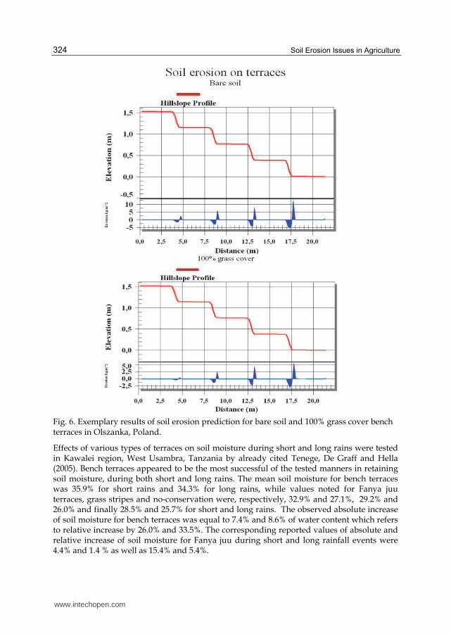
Predicted rates of soil loss showed considerable reduction of sediments yield after application of bench terraces on modeled slope. But one should note that implementation of vegetation cover on untransformed slope may be also very effective – e.g. 50% grass cover gives comparable results than terracing with bare soil surface, 55.1% vs. 51.7%. Thus, combination of terracing and 100% cover allowed to obtain the highest level of soil loss reduction – 77.4% predicted. Presented calculations also showed specific characteristics of soil erosion by water on bench terraces. Figure 6 shows slope profile and relative soil erosion for modeled section of bench terraces. As it was described before, risers appeared the most prone element of terrace to soil erosion – calculated soil loss reached level of 3.124 kg m-2 per year for the last, fourth riser in the section. On the other hand, the nearly level platforms trigger deposition of transported sediments. The predicted values of deposition were in range from 0.439 to 5.387 kg m-2 per year. However, the presented predictive calculations lack empirical validation.
4. Soil moisture and infiltration on terraces
4.1 Reported effects of terracing on soil moisture and infiltration
Limiting surface runoff generation and speed resulting in increased infiltration and soil moisture content of soil profiles located on eroded slopes is one of the main tasks fulfilled by terracing (e.g. Tenge et al., 2005). Gathering rain water is accomplished by several constructional elements of various types of terracing: level, nearly level or back slope platforms, embankments, draining ditches or other draining elements. Exemplary report by Li et al. (1994, as cited by Lü et al., 2009) describing efficiency of terracing as soil conservation measure in selected watershed at Loess Plateau, China presented an increase of soil moisture by 20.7%, a decrease of soil removal and nutrients loss by 57.9%-89.9% and 89.3% - 95.9%, respectively, as the most important indicators of terracing effects. Another studies conducted at Danangou catchment, Loess Plateau in China, by Fu et al. (2003) covered five land use structures and seven land use types, including terracing. Reported results of studies showed that mean soil water content for cropland on terraces was higher than that on slope orchard, fallow land, grassland and cropland on almost uniform slope – 15.2% vs. 11.15%, 11.09%,10.82% and 11.1%, respectively.
www.intechopen.com
Soil Erosion Issues in Agriculture 324
Fig. 6. Exemplary results of soil erosion prediction for bare soil and 100% grass cover bench terraces in Olszanka, Poland.
Effects of various types of terraces on soil moisture during short and long rains were tested in Kawalei region, West Usambra, Tanzania by already cited Tenege, De Graff and Hella (2005). Bench terraces appeared to be the most successful of the tested manners in retaining soil moisture, during both short and long rains. The mean soil moisture for bench terraces was 35.9% for short rains and 34.3% for long rains, while values noted for Fanya juu terraces, grass stripes and no-conservation were, respectively, 32.9% and 27.1%, 29.2% and 26.0% and finally 28.5% and 25.7% for short and long rains. The observed absolute increase of soil moisture for bench terraces was equal to 7.4% and 8.6% of water content which refers to relative increase by 26.0% and 33.5%. The corresponding reported values of absolute and relative increase of soil moisture for Fanya juu during short and long rainfall events were 4.4% and 1.4 % as well as 15.4% and 5.4%.
www.intechopen.com

Terracing as a Measure of Soil Erosion Control and Its Effect on Improvement of Infiltration in Eroded Environment 325
Interesting studies concerning various soil and water conservation techniques for cashew (Anacardium occidentale L.) cultivation were conducted in Puttur, Karnataka, India by Rejani and Yadukumar (2010) during the period of 2004-2010. Tested soil and water conservation techniques covered crescent bunds, coconut husk burial, reverse (back slope) terraces, catch pits and contour plot without any manner of conservation. Despite the fact, that according to the cited report, crescent bunds and coconut husk burial appeared to be the most effective in increasing soil moisture, terracing also showed some significant potential. The mean value of soil moisture for tested terraces system observed at three various depths (0-30 cm, 30-60 cm and 60-90 cm) during long-lasting experiment was equal to 14.6 % while soil moisture for system without any means of soil and water conservation was 11.6% (Rejani & Yadukumar, 2010). Thus, mean soil moisture of eroded slope with terraces was approx. 25.9 % higher than on non-terraced plot. All the presented above, exemplary, scientific reports showed a significant potential of various types of terraces in increasing infiltration rate and resultant soil moisture content. Observed increases of soil moisture were dependant on slope inclination, local soil conditions, vegetation cover, terraces construction and climatic conditions.
4.2 Modeling of infiltration on terraces with sand-filled draining ditches
Modeling of infiltration efficiency on terraces was conducted for soil control system developed and tested on loess soils in Olszanka (Rubaj, 2002; Widomski et al., 2010) – Fig. 2. Numerical calculations were conducted to assess the increase of infiltration resultant from application of additional sand-filled drainage ditches to traditional level bench terraces. Commercial software FEFLOW by Wasy Ltd., Germany, based on finite elements method (FEM) was used in the numerical calculations. FEFLOW is a well known and repeatedly successfully verified model of groundwater movement, mass and heat transport in saturated or unsaturated porous media (Diersch & Kolditz, 2002; Mazzia & Putti, 2006; Trefry & Muffeles, 2007; Zhao et al., 2005). Numerical calculations were conducted on model consisting of a line of contiguous terraces (Fig. 2), with and without draining ditches, thus calculations were conducted for two various variants allowing to compare infiltration rate for ordinary bench terrace and terrace equipped with sand-filled draining ditch for two different locations on slope. Numerical calculations of water movement in soil profile were based on standard form of Darcy’s and Richard’s equations (e.g. Pachepsky et al., 2003; Raats, 2001; Richards, 1931):
圏 = −計岫肯岻稿 (1)
弟提弟痛 = 稿岫計岫肯岻稿岻 − 鯨岫肯岻 (2)
where: q – groundwater flux, - volumetric water content, t – time, 計岫肯岻 – hydraulic conductivity, - water potential, 鯨岫肯岻 – sink or source term. The mathematical description of water retention curve shape adapted to presented calculations was presented by Mualem (1976):
肯 = 提濡貸提認岷怠袋岫底朕岻韮峅尿 + 肯追 (3)
where: s – saturated volumetric water content, r – residual volumetric water content, h – soil matric suction pressure, , n, m – fitting parameters, m = 1-n-1.
www.intechopen.com

Soil Erosion Issues in Agriculture 326
The above formula may be also presented in degree of saturation based form (i.e. Diersch 2005):
鯨 = 聴濡貸聴認岷怠袋岫底泥岻韮峅尿 + 鯨追 , 岫閤 < ど岻 (4)
where: – groundwater pressure potential. Relative hydraulic conductivity of unsaturated soils was calculated in the presented model according to van Genuchten’s formula (1980):
計 = 計鎚銚痛鯨鎮 釆な − 岾な − 鯨 迭尿峇陳挽態 (5)
where: K – relative unsaturated conductivity, Ksat – saturated conductivity, S – saturation fraction , l – fitting parameter, l = 0.5 (Diersch, 2005). The presented numerical calculations required the following set of input data: geometric characteristics of slope, terracing and draining ditches; soil physical and water-transport characteristics, vegetation cover data and initial and boundary conditions. Required input data were obtained by in-situ and laboratory measurements and literature studies.
4.2.1 Input data
Soil physical and transport characteristics were studied in three layers at two different locations. Saturated hydraulic conductivity of soils was measured in situ by double-ring infiltrometer and in laboratory by soil permeameter, both manufactured by IMUZ, Poland. Water retention curves for tested soils were obtained by sand and plaster box, IMUZ, Poland. According to literature reports (Stauffer & Kinze, 2001; Werner & Lockington, 2003) single-valued mean retention curves were applied as adequate to time-average soil moisture profiles. Soil anisotropy ratio was obtained by cubic samples method (Iwanek, 2008). Input data covering characteristics of tested soils are presented in Table 6.
Loc
atio
n
Depth, cm
Saturated conductivity
Ks, m d-1
Ani
sotr
opy
rati
o
Saturated water contents, m3 m-3
Residual water
content r, m3 m-3
Fitting parameter , cm-1
Fitting parameter
n
Top
of
slop
e
0–10 0.479 2.770 0.3667 0.065 0.0029 1.8902
10–50 0.480 1.150 0.3844 0.050 0.0039 1.3644
50–100 0.480 1.150 0.406 0.050 0.0048 1.3816
Bot
tom
of
slop
e
0–10 0.492 2.302 0.3895 0.07 0.0051 1.4245
10–50 0.620 0.870 0.4428 0.051 0.0082 1.3664
50–100 0.620 0.870 0.4434 0.051 0.009 1.3572
Sand
in
dit
ch 10–80 7.690 1.000 0.42 0.010 0.0100 1.9600
Table 6. Characteristics of soils accepted to numerical studies
www.intechopen.com

Terracing as a Measure of Soil Erosion Control and Its Effect on Improvement of Infiltration in Eroded Environment 327
The following initial and boundary conditions were assumed to modeling: - initial conditions covering soil moisture distribution in the tested terraces profile based
on soil moisture in-situ measurements by manually operated TDR by Easy Test, Poland with accuracy of 2.0% of measuring scale;
- bottom boundary Dirichlet condition covering time dependent groundwater head obtained by water retention curves and volumetric soil moisture measurements;
- upper boundary Neumann condition describing inflow and outflow to the model, covering observer rainfall as well as runoff and evapotranspiration calculated by SWAP (Ben-Asher et al., 2006; Eitzinger et al., 2004; Sawar & Feddes, 2000);
- side Neumann gradient-type boundary condition allowing free movement of ground water.
Additional input data, such as climatic conditions covering air temperature and humidity, wind speed and precipitation, required to calculate mean daily evapotrnaspiration, were obtained by local weather station. Grass cover’s roots distribution was measured in-situ, while value of Leaf Area Index (LAI) was based on literature studies (Mitchell et al., 1998). Values of measured precipitation and calculated evapotranspiration applied to numerical modeling are shown on a bar chart presented on Fig. 7.
Fig. 7. Daily evapotranspiration and precipitation used as input data in modeling
4.2.2 Results of infiltration modeling
Modeling of infiltration on bench terraces and bench terraces with additional sand-filled draining ditches in soil and climatic conditions of Olszanka, Poland field site was conducted for the period of 74 days in summer of 2003 (17th June to 29th August). This period of simulation was selected according to various observed rainfall events – 24 events, precipitation from 0.5 mm to 34.8 mm. Assessment of infiltration was conducted for the elemental horizontal cross section located 1.0 below the ground surface and with span equal to the length of level platform of terrace, thus dimensions of the virtual surface were 1.0 m width and 4.0 m length. Fig. 8 shows curves presenting accumulated infiltration for two tested terraces, with and without sand-filled draining ditch, for two various locations on the tested slope (top and bottom). In both tested cases the higher calculated infiltration was noted for the terraces equipped with draining ditch. This result may be explained by location of the tested terraces
www.intechopen.com

Soil Erosion Issues in Agriculture 328
along the slope – terrace located at the base of the slope shows lower total infiltration because of different soil characteristics, higher run off speed and higher initial moisture content. In both cases the presented calculations indicate the proper reaction on rainfall appearance. The total volume of infiltrated water for all tested cases during the whole period of simulation is presented in Table 7.
Fig. 8. Calculated accumulated infiltration for two tested bench terrace locations, with and without sand-filled ditches
The calculated total volume of infiltration for two studied types of bench terrace, with and without sand draining ditch, reached the values of 0.217 m3 – 0.188 m3 for top part of the slope and 0.093 m3 – 0.082 m3 for bottom part of slope. Thus, mean daily infiltration rate
www.intechopen.com

Terracing as a Measure of Soil Erosion Control and Its Effect on Improvement of Infiltration in Eroded Environment 329
calculated for terrace located at top part of the slope for observation period was equal to 2.94 dm3 day-1 for terrace with sand-filled ditch and 2.54 dm3 day-1 without it. Results of the conducted calculations obtained for terrace located at bottom part of the slope showed daily mean infiltration rate of 1.26 dm3 day-1 and 1.11 dm3 day-1 for terraces with additional draining elements and without it. Despite the fact that total accumulated volume of infiltrated water and daily mean infiltration rate varies significantly for the two tested terraces, with and without sand ditches, located at different parts of the slope, the observed increase of calculated infiltration in both cases reaching the level of 15.60% – 14.08% is similar and clear.
Location Terracing type Total infiltration
volume, m3 Infiltration volume
increase, %
Top part of slope
Standard bench terrace
0.188041
15.60 Bench terrace with sand-filled draining
ditch
0.216909
Bottom part of the slope
Standard bench terrace
0.081575
14.08 Bench terrace with sand-filled draining
ditch
0.093059
Table 7. Calculated infiltration volume for tested terraces in two various on-slope locations
Empirical validation of presented numerical model was conducted by comparison of daily measured (19.00 p.m.) and calculated values of soil volumetric water content for the whole period of simulation (74 days), for four measurements locations – at the depth of 35 and 50 cm below the ground surface for each tested terrace. However, equipment failures and days off of the measuring staff resulted in reducing the number of applicable observations to 58 pairs. The observed coefficients of determination derived from linear regression of measured values of volumetric soil moisture vs. calculated ones were in range of R2=0.702-0.799 (P=0.05). Thus, the values of soil moisture obtained by numerical modeling are in good agreement with the values measured in situ.
5. Summary
Various types of terracing are a common, worldwide known, method of soil erosion control. Among all described tasks of terraces the most important are: limiting the soil erosion rate and improving water balance of eroded basins by increased infiltration of surface water into deeper layers of soil profile. Presented literature reports proved that different types of terracing, in various local soil and climatic conditions, with different vegetation cover, are successful in decreasing soil removal by water erosion. The maximum level of soil loss decrease observed in the cited studies was equal to approx. 90%. Additionally, conducted numerical prediction of mean annual soil erosion for bench
www.intechopen.com

Soil Erosion Issues in Agriculture 330
terraces constructed in fruit farm in Olszanka, Poland showed a significant decrease of calculated soil loss obtained due to terracing application. Moreover, numerical calculations showed the importance of vegetation cover strengthening the soil surface in limiting soil removal by surface run-off. Various studies reported in literature also proved the importance of terracing, especially additionally equipped with elements limiting run-off speed, in increasing the infiltration of surface water into the soil. Maximum reported increase of mean soil volumetric water content was approximately equal to 20%. The presented numerical assessment of efficiency of sand-filled ditches installed on bench terraces in Olszanka, Poland showed that total volume of infiltration increase in the tested terracing system was approx. 15% higher than for traditional bench terraces. Advantages of various types of terracing should entrant to their wider application, but one should also remember that terraces are relatively costly in construction and maintaining, especially terraces equipped with various elements redirecting surface run-off and increasing infiltration.
6. References
Amore, E.; Modica, C.; Nearing, M.A. & Santoro, V.C. (2004). Scale effect in USLE and WEPP application for soil erosion computation from three Sicilian basins. Journal of
Hydrology 293, pp.100–114 Ananda, J. & Herath, G. (2003). Soil erosion in developing countries: a socio-economic
appraisal. Journal of Environmental Management 68, pp. 343-353 Arnanez, J.; Larrea V. & Ortigosa, A. (2004). Surface runoff and soil erosion on unpaved
forest roads from rainfall simulation tests in northeastern Spain. Catena 57, pp. 1 –14
Askoy, H. & Kavvas, M.L. (2005). A review of hillslope and watershed scale erosion and sediment transport models. Catena 64, pp. 247-271
Basic, F.; Kisic, I.; Mesic, M.; Nestroy, O. & Butorac, A. (2004). Tillage and crop management effects on soil erosion in central Croatia, Soil & Tillage Research 78, pp. 197–206
Ben-Asher, J.; van Dam, J.; Feddes, R.A. & Jhorar, R.K. (2006). Irrigation of grapevines with saline water. II. Mathematical simulation of vine growth and yield. Agricultural
Water Management 83, pp. 22–29 Beskow, S.; Mello, C.R.; Norton, L.D.; Curi, N., Viola, M.R. & Avanzi, J.C. (2009). Soil erosion
prediction in the Grande River Basin, Brazil using distributed modeling. Catena 79, pp. 49–59
Bhuyan, S.J.; Kalita, P.K.; Janssen, K. A. & Barnes, P.A. (2002). Soil loss predictions with three erosion simulation models. Environmental Modelling & Software 17, pp. 137–146
Cerdan, O.; Le Bissonnais, Y.; Couturier, A.; Bourennane, H. & Souchere, V. (2002). Rill erosion on cultivated hillslopes during two extreme rainfall events in Normandy, France. Soil Tillage Res. 67, pp. 99–108
Cots-Folch, R.; Martinez-Casasnovas, J.A. & Ramos, M.C. (2006). Land terracing for vineyard plantations in the north-eastern Spanish Mediterranean region: Landscape effects of the EU Council Regulation policy for vineyards’ restructuring. Agriculture, Ecosystems ad Environment 115, pp. 88-96
www.intechopen.com

Terracing as a Measure of Soil Erosion Control and Its Effect on Improvement of Infiltration in Eroded Environment 331
Dabney, S.M.; Liu, Z.; Lane, M.; Douglas, J.; Zhu, J. & Flanagan, D.C. (1999). Lendscape benching from tillage erosion between grass hedges. Soil & Tillage Research 51, pp. 219-231
Derbyshire, E. (2001). Geological hazards in loess terrain, with particular reference to the loess regions of China. Earth-Science Reviews 54, pp. 231–260
Diersch, H.J.G. & Kolditz, O. (2002). Variable-density flow and transport in porous media: approaches and challenges. Advanced Water Resources 25, pp. 899–944
Diersch, H.J.G. (2005). FEFLOW 5.2 Finite Element Subsurface Flow and Transport Simulation System, Reference Manual. WASY Ltd. Berlin
Eitzinger, J.; Trnka, M.; Hösch, J.; Žalud, Z. & Dubrovský, M. (2004). Comparison of CERES, WOFOST and SWAP models in simulating soil water content during growing season under different soil conditions. Ecological Modelling 171, pp. 223–246
Fu, B.; Wang, J.; Chen, L. & Qiu, Y. (2003). The effects of land use on soil moisture variation in the Danangou catchment of the Loess Plateau, China. Catena 54, pp. 197-213
Fullen, M.A.; Zhi, W.B. & Brandsma, R.T. (1998). A comparison of the texture of grassland and eroded sandy soils from Shopshire, UK. Soil & Tillage Research 46, pp. 301-305
Gobin, A.; Jones, R.; Kirkby, M.; Campling, P.; Govers, G.; Kosmas, C. & Gentile, A.R. (2004). Indicators for pan-European assessment nad monitoring of soil erosion by water. Environmental Science & Policy 7, pp. 25-38
Govers, G.; Poesen, J.; Goossens, D. & Christensen, B.T. (2004). Soil erosion-processes, damages and countermeasures. In Managing Soil Quality, Challenges in Modern
Agriculture, Schjonning P., & Elmholt, S. pp. 199–217, CABI Publishing. Wallingford Grønsten, H.A. & Lundekvam, H. (2006). Prediction of surface runoff and soil loss in
southeastern Norway using the WEPP Hillslope model. Soil & Tillage Research 85, pp. 186–199
Hammad, A.H.A.; Borresen, T. & Haugen, L.E. (2006). Effects of rain characteristics and terracing on runoff and erosion under Mediterranean. Soil & Tillage Research 87, pp. 39-47
Harbor, J. (1999). Engineering geomorphology at the cutting edge of land disturbance: erosion and sediment control on construction sites. Geomorphology 31, pp. 247–263
Iwanek, M. (2008). A Method of Measuring Saturated Hydraulic Conductivity in Anisotropic Soils. Soil Science Society of America Journal. 72, pp. 1527–1531
Jungerius, P.D.; Matundura, J. & van de Ancker, J.A.M. (2002). Road construction and gully erosion in West Pokot, Kenya. Earth Surface Processes and Landforms 27 (11), pp. 1237–1247
Kosams, C.; Gerontidis, St. & Marathianou, M. (2000). The effect of land use change on soils and vegetation over various lithological formations on Lesvos (Greece). Catena 40, pp. 51-68
Kuhlman, T.; Reinhard, S. & Gaaff, A. (2010). Estimating the costs and benefits of soil conservation in Europe. Land Use Policy 27, pp. 22–32
Lado, M. & Ben-Hur, M. (2004) Soil mineralogy effects on seal formation, runoff and soil loss, Applied Clay Science 24, pp. 209–224
www.intechopen.com

Soil Erosion Issues in Agriculture 332
Lü, H.; Zhu, Y.; Skaggs, T.H. & Yu, Z. (2009). Comparison of measured and simulated water storage in dryland terraces of the Loess Plateau, China. Agricultural Water
management 96, pp. 299-306 Mazzia, A. & Putti, M. (2006). Three-dimensional mixed finite element-finite volume
approach for the solution of density-dependent flow in porous media. Jour. Comp. and Appl. Math. 185, pp. 347–359
Mitchell, R.B.; Mosser, L.E.; Moore, K.J. & Redfearn, D.D. (1998). Tiller demographics and Leaf Area Index of four perennial pasture grasses. Agron. J. 90, pp. 47–53
Mohammad, A.G. & Adam, M.A. (2010).The impact of vegetative cover type on runoff and soil erosion under different land uses. Catena 81, pp. 97-103
Mualem, Y. (1976). A new model for predicting the hydraulic conductivity of unsaturated porous media. Water Resources Research, 12(3), pp. 513-522
Nakoa, S. (2000). Soil Conservation on Sloping Orchards in Japan, In: Soil and Water
Conservation and Management, 13.02.2011, Avaliable from: http://www.agnet.org/library/eb/451/
Nyssen, J.; Poesen, J.; Haile, M.; Moeyersons, J. & Deckers, J. (2000). Tillage erosion on slopes with soil conservation structures in the Ethiopian highlands. Soil & Tillage Research 57, pp. 115-127
Nyssen, J.; Veyret Picot, M.; Poesen, J.; Moeyersons, J.; Mitiku, H.; Deckers, J. & Govers, G. (2004). The effectiveness of loose rock check dams for gully control in Tigray, northern Ethiopia. Soil Use and Management 20, pp. 55–64
Pachepsky, Y.; Timlin, D. & Rawls, W. (2003). Generalized Richards’ equation to simulate water transport in unsaturated soils, Journal of Hydrology 272, pp. 3-13
Pandey, A.; Chowdary, V.M.; Mal, B.C. & Billib, M. (2008). Runoff and sediment yield modeling from a small agricultural watershed in India using the WEPP model. Journal of Hydrology 348, pp. 305-319
Pimentel, D. & Kounang, N. (1998). Ecology of soil erosion in ecosystems. Ecosystems 1, pp. 416-246
Raats, P. A. C. (2001). Development in soil-water physics since the mid 1960s. Geoderma 100, pp. 355-387
Ramos, M.C.; Cots-Folch, R. & Martinez-Casasnovas, J.A. (2007). Sustainability of modern land terracing for vineyard plantation in a Mediterranean mountain environment – The case of the Priorat region (NE Spain). Geomorphology 86, pp.1-11
Rejani, R. & Yadukumar, N. (2010). Soil and water conservation techniques in cashew grown along steep hill slopes. Scientia Horticulturale 126, pp. 371-378
Richards, L.A. (1931). Capillary conduction of liquids through porous mediums. Physics 1, pp. 318-333
Robinson, D.A. (1999). Agricultural practice, climate change and the soil erosion hazard in parts of southeast England. Applied Geography 19, pp. 13–27
Rubaj, J. (2002). Manner of surface and gully erosion control of soils and equipment of surface and gully erosion control of soils. (In Polish.) Polish Patent No. 188870
Sang-Arun, J.; Mihara, M.; Horaguchi, Y. & Yamaji, E. (2006). Soil erosion and participatory remediation strategy for bench terraces in northern Thailand. Catena 65, pp.258-264
www.intechopen.com

Terracing as a Measure of Soil Erosion Control and Its Effect on Improvement of Infiltration in Eroded Environment 333
Sawar, A. & Feddes, R.A. (2000). Evaluating drainage design parameters for the Fourth Drainage Project, Pakistan by using SWAP model: Part II – modeling results. Irrigation and Drainage Systems 14, pp. 281–299
Siebert, S.F. & Belsky, J.M. (1990). Bench terracing in the Kerinci uplands of Sumatra, Indonesia. Journal of Soil and Water Conservation 45, pp. 559-562
Stauffer, F. & Kinze, W. (2001). Cyclic hysteretic flow in porous medium column: model, experiment, and simulations. J. Hydrol. 240, pp. 264–275
Tenge, A.J.; De Graff, J. & Hella, J.P. (2005). Financial efficiency of major soil and water conservation measures in West Usambra highlands, Tanzania. Applied Geography 25, pp. 348-366
Trefry, M.G. & Muffels, Ch. (2007). FEFLOW: a finite-element ground water flow and transport modeling tool. Ground Water 45 pp. 525–528
Valentin, C.; Poesenm J. & Li, Y. (2005). Gully erosion: Impacts, factors and control. Catena 63, pp. 132–153
Van Dijk, A.I.J.M. & Bruijnzeel, L.A. (2003). Terrace erosion and sediment transport model: a new tool for novel soil conservation planning in bench terraced steeplands. Environmental Modelling & Software 18, pp. 839-850
van Genuchten, M.Th. (1980). A closed-form equation for predicting the hydraulic conductivity of unsaturated soils. Soil Science Society of America Journal 44, pp. 892-898
Van Lier, Q. de J.; Sparovek, G.; Flanagan, D.C.; Bloem, E.M. & Schnug, E. (2005). Runoff mapping using WEPP erosion model and GIS tools. Computers and Geosciences 31, pp. 1270-1276
Wang G., & Sassa K. (2003). Pore-pressure generation and movement of rainfall-induced landslides: effects of grain size and fine-particle content. Eng. Geol. 69, pp. 109–125
Werner, A.D. & Lockington, D.A.. 2003. Influence of hysteresis on tidal capillary fringe dynamics in a well-sorted sand. Advances in Water Resources 26, pp.1199–1204
Widomski, M. & Sobczuk, H. (2007). Retentional abilities of soils in eroded environment, In Environmental Engineering, Pawłowski L., Dudzińska M. & Pawłowski A., pp. 459 – 464, Taylor & Francis, New York – Singapore
Widomski, M.; Sobczuk, H. & Olszta, W. (2010) Sand-Filled Drainage Ditches for Erosion Control: Effects on Infiltration Efficiency, Soil Science Society of America Journal 74 (1), pp. 213-220
Zhang, K.L.; Shu, A.P.; Xu, X.L.; Yang, Q.K. & Yu, B. (2008). Soil erodibility and its estimation for agricultural soils in China. Journal of Arid Environments 72, pp. 1002–1011
Zhao, Ch.; Wang, Y.; Chen, X. & Li, B. (2005). Simulation of the effects of groundwater level on vegetation change by combining FEFLOW software. Ecological Modelling 187, pp. 341–351
Zhao, T.; Sun, B.; Gibo, S.; Wang, X. & Zhou, J. 2000. Loess landslide in China and its mechanism. Science Bulletin of the Faculty of Agriculture, University of the Ryukyus 47, pp. 113–121
www.intechopen.com

Soil Erosion Issues in Agriculture 334
Zuazo, V.H.D.; Ruiz, J.A.; Raya, A.M. & Tarifa, D.F. (2005). Impact of erosion in taluses of subtropical orchard terraces. Agriculture, Ecosystems ad Environment 107, pp. 199-210
www.intechopen.com

Soil Erosion Issues in AgricultureEdited by Dr. Danilo Godone
ISBN 978-953-307-435-1Hard cover, 334 pagesPublisher InTechPublished online 21, October, 2011Published in print edition October, 2011
InTech EuropeUniversity Campus STeP Ri Slavka Krautzeka 83/A 51000 Rijeka, Croatia Phone: +385 (51) 770 447 Fax: +385 (51) 686 166www.intechopen.com
InTech ChinaUnit 405, Office Block, Hotel Equatorial Shanghai No.65, Yan An Road (West), Shanghai, 200040, China
Phone: +86-21-62489820 Fax: +86-21-62489821
The book deals with several aspects of soil erosion, focusing on its connection with the agricultural world.Chapters’ topics are various, ranging from irrigation practices to soil nutrient, land use changes or tillagemethodologies. The book is subdivided into fourteen chapters, sorted in four sections, grouping different facetsof the topic: introductive case studies, erosion management in vineyards, soil erosion issue in dryenvironments, and erosion control practices. Certainly, due to the extent of the subject, the book is not acomprehensive collection of soil erosion studies, but it aims to supply a sound set of scientific works,concerning the topic. It analyzes different facets of the issue, with various methodologies, and offers a wideseries of case studies, solutions, practices, or suggestions to properly face soil erosion and, moreover, mayprovide new ideas and starting points for future researches.
How to referenceIn order to correctly reference this scholarly work, feel free to copy and paste the following:
Marcin K. Widomski (2011). Terracing as a Measure of Soil Erosion Control and Its Effect on Improvement ofInfiltration in Eroded Environment, Soil Erosion Issues in Agriculture, Dr. Danilo Godone (Ed.), ISBN: 978-953-307-435-1, InTech, Available from: http://www.intechopen.com/books/soil-erosion-issues-in-agriculture/terracing-as-a-measure-of-soil-erosion-control-and-its-effect-on-improvement-of-infiltration-in-erod

© 2011 The Author(s). Licensee IntechOpen. This is an open access articledistributed under the terms of the Creative Commons Attribution 3.0License, which permits unrestricted use, distribution, and reproduction inany medium, provided the original work is properly cited.