test wells, gubik area alaska - usgs wells, gubik area alaska by florence m. robinson with...
TRANSCRIPT

Test Wells, Gubik Area AlaskaEXPLORATION OF NAVAL PETROLEUM RESERVE NO 4
AND ADJACENT AREAS, NORTHERN ALASKA, 1944-53
PART 5, SUBSURFACE GEOLOGY AND ENGINEERING DATA
GEOLOGICAL SURVEY PROFESSIONAL PAPER 305-C
Prepared and published at the request of and
in cooperation with the U. S. Department of
the Navy, Office of Naval Petroleum and
Oil Shale Reserves


Test Wells, Gubik Area AlaskaBy FLORENCE M. ROBINSON
With Micropaleontologic Study of the Gubik Test Wells, Northern AlaskaBy HARLAN R. BERGQUIST
EXPLORATION OF NAVAL PETROLEUM RESERVE NO. 4 AND ADJACENT AREAS, NORTHERN ALASKA, 1944-53
PART 5, SUBSURFACE GEOLOGY AND ENGINEERING DATA
GEOLOGICAL SURVEY PROFESSIONAL PAPER 305-C
Prepared and published at the request of and
in cooperation with the U. S. Department of
the Navy, Office of Naval Petroleum and
Oil Shale Reserves
UNITED STATES GOVERNMENT PRINTING OFFICE, WASHINGTON : 1958

UNITED STATES DEPARTMENT OF THE INTERIOR
FRED A. SEATON, Secretary
GEOLOGICAL SURVEY
Thomas B. Nolan, Director
For sale by the Superintendent of Documents, U. S. Government Printing OfficeWashington 25, D. C.

CONTENTS
Abstract.__________________________________________Introduction. ______________________________________
Acknowledgments. ______-_--__--__--____________Structure __________________________________________Purpose of tests.__ ____--__-_______________________Stratigraphy. ______________________________________Quaternary deposits_______________________________
Alluvium. _____________________________________Cretaceous rocks______-_-_-_____-________--_______
Colville group (Upper Cretaceous)________________Schrader Bluff formation.___________________Prince Creek formation______________________Seabee formation ___________________________
Nanushuk group (Lower and Upper Cretaceous) ____Chandler and Ninuluk formations undifferen-
tiated ___-__--__--_____---_---__--______.Grandstand formation_______________________
Topagoruk formation.___________________________Heavy-mineral studies.._____________________________Gubik test well 1___________________________________
Description of cores and cuttings-______--_--_____Core analyses._-__-_____---__--__-_-___________Oil and gas.___________________________________
Oil and gas shows___________________________Formation tests. ___________________________Gas analyses.__-___-___--_-__-_--_-_--_____
Logistics _____________________________________Transportation.____________________________Housing-_________________ _________________Personnel. _________________________________Vehicles and drilling equipment_____________Fuel, water, and lubricant consumption________
Drilling operations._____________________________Rig foundation.____________________________Drilling notes.-___--_--_--_-__--___-_______Drill and core bits._______--___--__--_______Drilling mud_______________________________Hole-deviation record_______________________Electric logging___________________________
Page 207 207 207207208209209209209209209210210211
211211212212212214227228228228229229229229229229229229229229230230231231
Page Gubik test well 2_ _____________-__ _-_______-__-__ 231
Description of cores and cuttings.________________ 231Core analyses____________-_-_____---___-_--_--_ 251Oiland gaB___---_.-------_-__-_-__-_-___-__- 252
Oil and gas shows_________________________ 252Formation tests. ___________________________ 253Significance of oil and gas shows and tests.____ 254
Logistics. __ _ ___---_-____--___---------_-------_ 255Drilling operations._.____-____-____-____-_-___-_ 255
Rig foundation___-___-___--___-____--__-___ 255Drilling notes._____________________________ 255Blowout-__-_-_---__------------_---_-_--__ 255Drill and core bits._________________________ 256Drilling mud_____________________________ 256Hole-deviation record,______________________ 256Electric logging___________________________ 256
Literature cited___________________________________ 257Mieropaleontologic study of the Gubik test wells, northern
Alaska, by Harlan R. Bergquist------.---.-.-.--,.-- 259Gubik test well l--_-_-_-___-_-_-___-______-___- 259
Schrader Bluff formation (67-890 feet) _ _ _ _ _ _ 259Tuluvak tongue of the Prince Creek formation
(890-1,760 feet)___________________ 260Seabee formation (1,760-3,305 feet)___________ 260Ninuluk formation and Killik tongue of the
Chandler formation (3,305-3,735 feet) ___ 260 Verneuilinoides borealis faunal zone (3,735 feet
to total depth)______.____________________ 260Gubik test well 2___________________________ 260
Schrader Bluff formation (160-1,135 feet)____ 260 Tuluvak tongue of the Prince Creek formation
(1,135-2,010 feet) ____________.-.___ 260Seabee formation (2,010-3,585 feet) _______ 261 Ninuluk formation and Killik tongue of the
Chandler formation undifferentiated (3,585- 4,025 feet)_________________....__.. 261
Verneuilinoides borealis faunal zone (4,025 feet to total depth)_.___________1_______ 261
Bibliography of the micropaleontologic study___-_-_ 261 Index. ____._______-.___.________________ 263
ILLUSTRATIONS[Plates 13,15,16 are in pocket]
Page
PLATE 13. Map showing the location of test wells on the Gubik anticline.
14. Gubik test well 1, camp, and drilling rig Faces 21215. Graphic log of Gubik test well 1.16. Graphic log of Gubik test well 2.
Page FIGURE 11. Index map of northern Alaska_________ 208
12. Cretaceous section penetrated on the Gubikanticline_ _ _--_--_--_-______.__-_____ 209
13. Relative abundance of heavy minerals in theGubik test wells__-__________________ 213
in


EXPLORATION OF NAVAL PETROLEUM RESERVE NO. 4 AND ADJACENT AREAS, NORTHERN ALASKA, 1944-53
TEST WELLS, GUBIK AREA, ALASKA
By FLORENCE M. ROBINSON
ABSTRACT
From 1944 to 1953 the U. S. Navy, through its contractor and assisting Government agencies, explored the petroleum possibil ities of Naval Petroleum Reserve No. 4 and adjoining areas in northern Alaska. In the course of this exploration, seismic, magnetic, and gravimetric geophysical surveys and field geologic surveys were made, and a test-well drilling program was under taken.
Two tests were drilled on the Gubik anticline, which is about 180 miles southeast of Point Barrow. The two wells were little more than a mile apart, and the same Upper and Lower Cretaceous rocks were penetrated. Gas was discovered at two horizons: in the Tuluvak tongue of the Prince Creek formation, and in the Chandler and Ninuluk formations undifferentiated. Gubik test well 1 was drilled to 6,000 feet then plugged and abandoned; Gubik test well 2 was drilled to 4,620 feet; it then blew out, caught fire, and was subsequently abandoned.
INTRODUCTION
In the course of the exploration of Naval Petroleum Reserve No. 4, northern Alaska (Robinson, 1956, p. 1-3), two test wells were drilled on the Gubik anticline, 180 miles southeast of Barrow and approxi mately 16 miles northeast of Umiat near latitude 69°26' N. and longitude 151°28' W. (See fig. 11.) The Gubik anticline extends eastward between the Anak- tuvuk and Colville Rivers across the mouth of the Chandler River. The presence of the anticline was reported in 1945 by a reconnaissance geologic field party, and its structural features were later defined by geologic mapping and reflection seismograph work. The name "Gubik" is a variant of the Eskimo word for "Big River," the native name applied to the lower Colville River.
The test wells are on a low gravel terrace 10-12 feet above the normal river level on the west side of the Chandler River a short distance above its mouth. (See pi. 13.) In general, the area near the confluence of the Colville, Chandler, and Anaktuvuk Rivers is one of low rolling hills at the northern edge of the northern foot hills of the Brooks Range. Close to its mouth, the
Anaktuvuk River flows through a broad valley with low bluffs. The valley of the Chandler is narrower and has steeper walls, which are 50 to several hundred feet high.
The test wells were drilled into Upper and Lower Cretaceous strata. Gas in commercial quantities was found in two separate sandstone beds 1,500 feet apart stratigraphically. A detailed description of the rocks examined and the logistic, engineering, drilling, and production data are assembled in this paper.
ACKNOWLEDGMENTS
Engineering information presented here is taken largely from the weekly, completion, and final reports made to the U. S. Navy by Arctic Contractors. United Geophysical Co. did most of the geophysical work, and the Schlumberger Well Surveying Corp. recorded all but one of the electric log runs. Gas analyses were made by the U. S. Bureau of Mines at Bartlesville, Okla., and some core analyses were made by Core Laboratories, Inc., of Dallas, Tex. The help of persons connected with these organizations is gratefully acknowledged.
Lithologic descriptions and other core analyses were made by the author in the Fan-banks laboratory of the U. S. Geological Survey. Members of the Geological Survey whose work is included are Harlan R. Bergquist, who identified the microfossils; Ralph W. Imlay, who identified the Lower Cretaceous megafossils, and George Gryc, who identified the Upper Cretaceous megafossils; Robert H. Morris, who established heavy-mineral zones; and Roland W. Brown, who identified plant fossils. The stratigraphic distribution of microf ossils in the test wells of northern Alaska will be presented by H. R. Bergquist in another chapter of this series.
STRUCTURE
The Gubik anticline was first noted by a Geological Survey reconnaissance field party descending the
207

208 EXPLORATION OF NAVAL PETROLEUM RESERVE NO. 4, ALASKA, 1944-53
148*
1 SOUTH BARROW TEST WELL 12 SOUTH BARROW TEST WELL 23 SOUTH BARROW TEST WELL 34 SOUTH BARROW TEST WELL 45 AVAK TEST WELL t6 NORTH SIMPSON TEST WELL 1
7 SIMPSON TEST WELL 18 TOPAGORUK TEST WELL 19 EAST TOPAGORUK TEST WELL 1
10 FISH CREEK TEST WELL 111 KAOLAK TEST WELL 112 MEADE TEST WELL 1
13 OUMALIK TEST WELL 114 EAST OUMALIK TEST WELL 115 SQUARE LAKE TEST WELL 116 TITALUK TEST WELL I17 WOLF CREEK TEST WELL 118 WOLF CREEK TEST WELL 2
19 WOLF CREEK TEST WELL 320 GUBIK TEST WELL. 121 GUBIK TEST WELL 222 KNIFEBLADE TEST WELL 123 KNIFEBLADE TEST WELLS 2 AND 2A24 GRANDSTAND TEST WELL 125 UMIAT TEST WELLS 1-11
FIGURE 11. Index map of northern Alaska, showing location of test wells and oil fields.
Anaktuvuk River in 1945. In 1947 another Geo logical Survey party found that the anticline plunges west near the Colville River. In 1945 and 1946 an airborne magnetometer survey was made of part of the Reserve and adjoining areas by the Geological Survey in a joint effort with the U. S. Navy. This survey included the area around the Gubik anticline. The Gubik test wells are at the northwestern end of an elongate magnetic high, which parallels the much larger high associated with the Umiat anticline to the southwest.
As a followup of the surface geologic mapping, a seismograph crew in 1950 shot two lines on the west end of the Gubik anticline. East closure was mapped during the same summer by a Survey party, and a detailed seismic survey to completely delineate the Gubik structure was made the following year. No gravity work was done in the Gubik area.
The area of closure on seismic horizon "A," a phantom horizon in the Grandstand formation of Cretaceous age, extends eastward; it is about 12 miles long and has a minimum width of a little over 2% miles. (See pi. 13.) Closure is at least 400 or 500 feet and average dip on the flanks is about 3°. Seismic reflections were good on the flanks of the anticline, but poor on the crest. Below a depth of 4,000 feet, no satisfactory reflections were obtained; apparently most of the section is shale. No seismic evidence of faulting was noted.
PURPOSE OF TESTS
Gubik test well 1 was drilled near the apex of the Gubik anticline to test the oil and gas possibilities between the surface and the bottom of the sands that are productive on the nearby Umiat anticline (Collins, 1958). Gas in commercial quantities was found at a depth of 890 to 1,750 feet in the sandstones of the Tuluvak tongue in the Prince Creek formation (Upper Cretaceous) and at a depth of 3,350-3,700 feet in the sandstones of the Chandler and Ninuluk formations undiff erentiated.
The producing strata at Umiat, the upper and lower sandstone beds of the Grandstand formation, ap parently become finer grained eastward and in Gubik test well 1 are represented only by siltstone with a few thin beds of sandstone. Surprisingly good cuts were obtained from the silty clays in cores 42-44 and in core 50 of Gubik test well 1, considering the "tight" nature of these rocks.
Gubik test well 2 was drilled on the south flank of the anticline to test for oil in sands which were gas bearing or showed reservoir properties in Gubik test well 1, to determine the extent of the gas deposit in each gas-bearing sand, and to determine the depths of any gas-oil, gas-water, or oil-water contacts that might be penetrated. Both gas and oil shows were found. A discussion of these shows by C. L. Mohr, chief of
TEST WELLS, GUBIK AREA, ALASKA 209
exploration, Arctic Contractors, can be found on page 254. Unfortunately, the well blew out and was abandoned before the testing was completed. -
STRATIGRAPHY
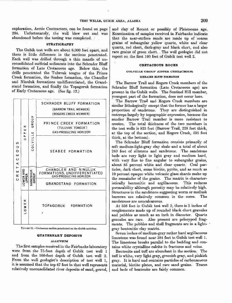
The Gubik test wells are about 6,000 feet apart, and there is little difference in the sections penetrated. Each well was drilled through a thin mantle of un- consolidated sufficial sediments into the Schrader Bluff formation of Late Cretaceous age. Below this, the drills penetrated the Tuluvak tongue of the Prince Creek formation, the Seabee formation, the Chandler and Ninuluk formations undifferentiated, the Grand stand formation, and finally the Topagoruk formation of Early Cretaceous age. (See fig. 12.)
enID
OUl
0
H-
Ul
o:o
oc.UJ
a.a.ID
aza: ujLU O.
o 3
irUl
0
a.13OccO
Ul
^>
Ou
^ *_
3^
^0Z^
Z
SCHRADER BLUFF FORMATION
(BARROW TRAIL MEMBER)
(ROGERS CREEK MEMBER)
PRINCE CREEK FORMATION(TULUVAK TONGUE)
GAS-PRODUCING HORIZON
SEABEE FORMATION
FORMATIONS, UNDIFFERENTIATEDGAS-PRODUCING HORIZON
GRANDSTAND FORMATION
TOPAGORUK FORMATION
x
FIGURE 12. Cretaceous section penetrated on the Gubik anticline.
QUATERNARY DEPOSITS
ALLUVIUM
The first samples received in the Fairbanks laboratory were from the 75-foot depth of Gubik test well 1 and from the 160-foot depth of Gubik test well 2. From the well geologist's description of test well 1, it is assumed that the top 67 feet in that well represents relatively unconsolidated river deposits of sand, gravel,
and clay of Recent .or possibly of Pleistocene age. Examination of samples received in Fairbanks indicate that the near-surface sands are made up of coarse grains of subangular yellow quartz, white and clear quartz, red chert, dark-gray and black chert, and also rare grains of green chert. The well geologist did not report on the first 160 feet of .Gubik test well 2.
CRETACEOUS BOCKS
COLVILLB GROUP (UPPER CRETACEOUS)
SCHRADER BLUFF FORMATION
The Barrow Trail and Rogers Creek members of the Schrader Bluff formation (Late Cretaceous age) are present in the Gubik wells. The Sentinel Hill member, youngest part of the formation, does not occur here.
The Barrow Trail and Rogers Creek members are similar lithologically except that the former has a larger proportion of sandstone. They are distinguished in outcrops largely by topographic expression, because the sandier Barrow Trail member is more resistant to erosion. The total thickness of the two members in the test wells is 823 feet (Barrow Trail, 228 feet thick, at the top of the section, and Rogers Creek, 595 feet thick, at the bottom).
The Schrader Bluff formation consists primarily of soft medium-light-gray clay shale and a total of about 240 feet of siltstone and sandstone. The sandstone beds are very light to light gray and medium hard, with very fine to fine angular to subangular grains, about 85 percent white and clear quartz. Coal par ticles, dark chert, some biotite, pyrite, and as much as 10 percent opaque white volcanic glass shards make up the remainder of the grains. The matrix is character istically bentonitic and argillaceous. This reduces permeability although porosity may be relatively high. Structures in the sandstone suggesting worm or mollusk burrows are relatively common in the cores. The sandstones are noncalcareous.
At 336 feet in Gubik test well 2, there is 3 inches of conglomerate made up of rounded black chert granules and pebbles as much as an inch in diameter. Quartz granules are rare. Also present are pelecypod frag ments. The pebbles and shell fragments are in a light- gray bentonitic clay matrix.
Seven inches of medium-gray rather hard argillaceous limestone was found near 384 feet in Gubik test well 1. The limestone breaks parallel to the bedding and con tains white crystalline calcite in fractures and veins.
Bentonite and tuff are abundant in the section. The tuff is white, very light gray, greenish gray, and pinkish gray; It is hard and contains particles of carbonaceous material, biotite plates, and rare sand grains. Traces and beds of bentonite are fairly common.

210 EXPLORATION OF NAVAL PETROLEUM RESERVE NO. 4, ALASKA, 1944-53
The Schrader Bluff formation has a few microfossils and is probably marginal marine. A thick-shelled InoceramuSj possibly /. lundbreckensis McLearn, is present.
PRINCE CREEK FORMATION
The Tuluvak tongue of the Prince Creek formation underlies the Schrader Bluff formation in the Gubik area. It is 870 feet thick and is made up mostly of sandstone with some conglomerate, clay shale, coal beds, and bentonite.
The sandstone is light gray to medium light gray, soft and friable to moderately hard, and thin bedded to massive. Sandstone in the Tuluvak tongue is coarser grained than any of the older sandstones drilled in the Reserve. The grains are subangular to sub- rounded and range in size from very fine to very coarse, with a preponderance of the coarser material, including granules and pebbles. Generally, the larger sizes are better rounded. Fifty to eighty-five percent of the sand grains is white and clear quartz, and as much as 40 percent of the total is dark-gray and black chert. The coarser-grained sandstones have the larger propor tion of dark chert and consequently have a salt-and- pepper appearance in the hand specimen. Biotite, coal, ironstone, and white feldspar (?) particles, rare yellow quartz (?), pyrite, and rock fragments are the other constituents of the sandstone. The matrix ranges from argillaceous and sideritic to very calcareous. In a few beds the sandstone grades to silts tone. Rare tiny worm burrows similar to those in the Schrader Bluff formation are in the uppermost 50 feet of these beds. The effective porosity of the sandstone in the Tuluvak ranges from 4.4 to 25.4 percent, averaging about 15 percent, and the permeability, from imper meable to 3,780 millidarcys. Gas is present in the Tuluvak tongue.
Conglomeratic layers in the Tuluvak tongue are not common nor very thick. The conglomerate consists of rounded granules and pebbles of black chert and white quartz in a coarse sand matrix.
Twelve percent of the tongue is clay shale which is medium light gray to medium gray and ranges from soft to hard. Most of the clay shale has good cleavage except in the lower part of the section where some claystone is found. Bentonite is common throughout in beds as much as 2 feet thick and is also finely dis seminated in the clay shale. This bentonite is soft, white, very light gray, light gray, greenish gray, and bluish gray. The bentonitic shales are softer and of lighter color than the nonbentonitic clay shale. Ben tonite is rarely found in the matrix of the sandstones in contrast to the sandstone in the Schrader Bluff formation above, but is, in many places, closely asso ciated with coaly or carbonaceous layers. Carbona
ceous laminae, partings, and plajnt fragments are common hi both the clay shale and the sandstone. Coal, mostly in thin beds, is also common. It is shiny to dull and black and is rather brittle. Small amounts of clear yellow amber occur in the coal beds. The clay shale is much darker where associated with carbonaceous material. Thin hard medium-gray limestone layers are very rare. Calcite and aragonite in tiny veinlets in the limestone and clay shale were noted. Clay ironstone nodules and lenses are common in the forma tion. The Tuluvak section is mostly nonmarine as suggested by the abundance of carbonaceous material, coal, and plant fossils. However, some pelecypods (including Inoceramus) Foraminifera, and Radiolaria were found.
SEABEE FORMATION
In the Gubik test wells, 1,545 feet of marine clay shale and a small amount of silty sandstone make up the Seabee formation. In the subsurface the lithologic break between the Prince Creek and the Seabee forma tions is placed at the base of the major sandstone group and above a distinctive microfauna. (See p. 261.) In the type section (Detterman, in Gryc and others, 1956), the Ayiyak member, 360 feet of marine silts tone and sandstone, is described at the top of the Seabee forma tion. In the Gubik test wells the upper part of the section assigned to the Seabee formation is also partly sandy and probably represents the Ayiyak member. However, regional correlations in the subsurface suggest that there may be a small unconformity at the top of the Seabee formation, and because the boundaries of this member cannot be clearly defined lithologically in the subsurface at Gubik, the term "Ayiyak member" is not used here.
The 100 feet or so of sandy beds in the uppermost part of the Seabee formation contains marine pelecypods and some microfossils. The sandstone is light to me dium light gray, rather hard, and silty to fine grained and shows fair porosity but very low permeability; some has very calcareous cement. The sandstone contains 80 percent of white and cle^r quartz, and 20 percent of dark chert, rock fragments, coal particles and mica. The sandstone grades downward into silty and argillaceous beds.
Below this clastic unit is 900 feet of clay shale with scattered thin beds of siltstone. In the upper third of the Seabee formation the clay shale is medium light gray but becomes medium gray lower in the section; on the whole the shale is darker than the shale of other Upper Cretaceous formations. Slightly silty beds are common. White bentonite and light-colored benton itic shale are also found.
In certain parts of the 900-foot shaly Seabee forma tion, the clay shale is medium dark gray, breaks easily

TEST WELLS, GUBIK ABBA, ALASKA 211
parallel to the bedding, and characteristically is associ ated with thin beck and partings of light-colored bentonite, laminae of limestone and aragonite, thin- shelled Inoceramus Idbiatusf fragments and prisms, and fishbone fragments. These beds are probably correlative with the dark "paper shales" that crop out in the Umiat area and are lithologically distinctive in the Cretaceous section. The section between 3,040 and 3,100 feet in Gubik test well 2 is a good example of these beds.
Silty clay shale, siltstone, and sandstone make up the lowest 500 feet of the Seabee formation. The lower sandstone beds of this formation are light gray, hard, massive, and very fine to medium grained. The grains are subangular to subround, and 70-95 percent are white and clear quartz. Other constituents are chert, coal particles, rock fragments, and mica. Over a wide area these beds rest unconformably upon the Nanushuk group and closely resemble the sandstone of that group; they may represent reworked material from the older rocks. They can be differentiated from the sandstones of the Nanushuk group by the abundance of biotite plates, rock particles, and generally a very "dirty" matrix. A large part of the sandstone is silty and grades into siltstone. Argillaceous beds are the same as those described above in the 900-foot shaly part of the Seabee. Bentonite and limestone beds and fish fragments are rare. Inoceramus prisms and frag ments are common in both the core and cuttings. Mollusklike borings appear in the siltstone. "Swirly" beds present are the result of slump or deformation at the time of deposition. In one core a broken Inocera mus shell is embedded vertically in the distorted beds. The beds are noncalcareous to moderately calcareous, and porosity is fab", but permeability is very low. They are not good reservoir rocks and have very few shows of gas or oil.
NANUSHUK GROUP (LOWER AND UPPER CRETACEOUS)
CHANDLEB AND NINULUK FORMATIONS UNDIFFERENTIATED
Below the Seabee formation is 440 feet designated as the Chandler and Ninuluk formations undifferenti ated. The marine Ninuluk formation is the time equivalent of the upper part of the nonmarine Chandler formation (Kobinson, 1956, fig. 3). The upper 60 feet is definitely marine and could be assigned to the Ninu luk formation as both marine megafossils and micro- fossils typical of the Ninuluk formation were found. However, in the rest of the section the proportion of marine to nonmarine rocks cannot be determined; so the entire 440 feet has not been divided.
The sandstones of the Nanushuk group are similar to those of the Seabee formation above; sandstones of the Nanushuk, however, contain a smaller amount of
429370 58 2
argillaceous material in the matrix and are less cal careous. The grain size is also slightly coarser than that in the Seabee formation. Carbonaceous material and .clay ironstone are more common. The break between the Colville and Nanushuk groups is picked on the basis of lithologic evidence, as well as on a major change in microfauna and a change in heavy-mineral zones.
The Chandler and Ninuluk section, the lower of the two gas-producing beds in the Gubik anticline, is 86 percent of sandstone and siltstone and 14 percent of clay shale. The sandstone is light gray to medium light gray, hard, and mostly massive with irregular fracture. The grains range from silt to medium sand and are composed of 75-90 percent of white and clear quartz and varying amounts of dark-colored chert, coaly particles, mica, and rock fragments. Chalky white-weathered chert or feldspar particles, pyrite, and garnet are rare. The matrix is argillaceous and locally calcareous. At 3,603 feet in Gubik test well 1, the carbonate content is 38.3 percent by weight, but this high percentage is unusual.
The effective porosity of the sandstone beds ranges from 1.6 to 15.1 percent, and the permeability, from impermeable to 265 millidarcys. The sandstone at about 3,500 feet in Gubik test well 1 and at about 3,800 feet in Gubik test well 2 has the best porosity stone and permeability.
The siltstone is similar in composition to the sand stone but is medium light gray and more regularly bedded. Crossbedding, ripple marks, and "swirly" bedding were noted. Carbonaceous partings and very rare thin shiny black coal beds are present. Nodules and laminae of olive-gray and yellowish-gray clay iron stone are typical of the section.
The clay shale is medium to medium dark gray and moderately hard, has good cleavage, is finely micaceous, and has micaceous and carbonaceous partings. A small amount of the shale could be called claystone as it has poor or no cleavage.
A foot of hard medium-gray limestone occurs at 3,890 feet in Gubik test well 2. This limestone contains a thin vein of white calcite. The only occurrence of bentonite (very light gray) is in the well cuttings at about 3,655 feet in Gubik test well 1. A 3-inch bed containing abundant white oolites was found in Gubik test well 2 at 3,734 feet. The matrix and some of the oolites are very calcareous; other oolites appear to be composed of weathered chert and still others are coated with pyrite.
GRANDSTAND FORMATION
The transition from Chandler and Ninuluk forma tions undifferentiated to the Grandstand formation is gradational. The top of the predominantly marine

212 EXPLOBATION OF NAVAL PETROLEUM RESERVE NO. 4, ALASKA, 1944-53
Grandstand formation is marked approximately by the first appearance of the microfossils and megafossils of the Verneuilinoides borealis faunal zone.
. The Grandstand formation is 580 feet thick and composed of clay shale with about 30 percent of silt- stone and sandstone. The clay shale is medium to medium dark gray and moderately hard and has fairly good cleavage. A small proportion of it has poor cleavage. It is finely micaceous and has rare micaceous-carbonaceous partings as in the formation above. It is interbedded and gradational with silt- stone beds.
The remaining beds are silty clay shale, siltstone, and silty sandstone. The color ranges from light to medium gray, depending on the amount of sand; the more sand the lighter the color. The sand grains range from very fine to fine. Eighty-five percent or more is composed of subangular to subrounded white and clear quartz grains. The sandy, silty beds range from noncalcareous to calcareous. All beds tested were impermeable or had a permeability of less than 1 millidarcy. Effective porosity ranges from 3.9 to 11.1 percent. Good oil cuts were obtained from the more clastic beds. The sandstone of the Grandstand forma tion can be correlated with the producing beds at Umiat (Collins, 1958), but reservoir conditions, where tested on the Gubik anticline, are much poorer. The sandstones become finer grained northeast from Umiat.
There is a trace of bentonite or bentonitic clay shale in the upper part of the Grandstand formation. Thirty percent of a ditch sample at 4,130 feet in Gubik test well 2 is light-bluish-gray bentonite containing numerous plates of biotite and scattered subangular grains of quartz. Clay ironstone is very rare in the section, and carbonaceous or coaly partings are uncommon.
TOPAGORUK FORMATION
The oldest rocks reached by the Gubik test wells are in the Topagoruk formation. Gubik test well 1 was drilled through 1,685 feet, which was almost entirely clay shale; the bottom of the formation was not reached. Much of the clay shale is silty, but less than 75 feet is siltstone. Sandstone beds are very rare. The con tact between the Topagoruk and Grandstand forma tions is arbitrarily drawn where a much higher per centage of siltstone and sandstone is noticeable. There is no sharp break between the two formations.
The clay shale of the Topagoruk formation is mostly medium to medium dark gray, although lighter gray beds containing bentonite are present. The shale is moderately hard and has fair to excellent cleavage. It is silty and interbedded with numerous thin beds
and partings of medium-light-gray siltstone. The proportion of silt in the clay shale decreases with depth, and in the lowest part of the formation pene trated, silt is essentially absent. The few massive siltstone beds found are medium light gray and resemble those of the Grandstand formation.
White bentonite and bentonitic clay shale are quite common in the upper half of the formation drilled. Traces of coal also occur in this formation. Except for a calcareous matrix in a few silty beds, a trace of aragonite, and a trace of clay ironstone, carbonates are lacking in the Topagoruk formation.
A slight show of oil and gas was obtained from silty beds in this formation in core 50 at 5,441 feet of Gubik test well 1. Megafossils and microfossils of the Verneu ilinoides borealis faunal zone are present and the forma tion is marine in origin.
HEAVY-MINERAL STUDIES
Sixty-two heavy-mineral samples were taken from the two Gubik test wells and were analyzed by R. H. Morris as a part of his study of the heavy minerals of Naval Petroleum Reserve No. 4. He concludes that biotite and hornblende heavy-mineral zones are repre sented in the holes. The method of preparing samples and a short description of the various heavy-mineral zones (written before the Gubik wells were drilled) may be found in Morris and Lathram (1951). In Gubik well 1 the biotite zone ranges from 360 to 3,280 feet, and the hornblende zone, from 3,340 to 3,600 feet. In Gubik well 2 the biotite zone ranges from 320 to 3,540 feet, and the hornblende zone, from 3,620 to 4,080 feet. The biotite zone coincides with the Colville group, and the hornblende zone, with the upper part of the Nanushuk group. Figure 13 shows the range and abundance of biotite and hornblende and the other heavy minerals which were used to define the zones.
GUBIK TEST WELL 1
Location: Lat 69°26'46" N., long 151°28'06" W. Elevat'ftm: Ground, 144 feet; kelly bushing, 156 feet. Spudded: May 20, 1951.Completed: August 11, 1951, plugged and abandoned. Total depth: 6,000 feet.
Gubik test well 1 was drilled on the west side of the Chandler River (see pi. 14) a little more than a mile above its junction with the Colville River. The latitude and longitude given for this well and for Gubik test well 2 are subject to correction, because detailed topographic surveys had not been made of the area at the time the holes were located.

GEOLOGICAL SURVEY PROFESSIONAL PAPER 305 PLATE 14
A. WELL AND CAMP BESIDE CHANDLER RIVER
B. DRILLING RIG
GUBIK TEST WELL 1


TEST WELLS, GUBIK AREA, ALASKA 213
GUBIK TEST WELL 1
EXPLANATION
A
Rare, less than 10 percent Angular
Common, 10 to 40 percent Rounded
Abundant, 40 to 80 percentGUBIK TEST WELL 2
ROBERT H. MORRIS 1964
FIGURE 13. Relative abundance of heavy minerals in the Gubik test wells.

214 EXPLORATION OF NAVAL PETROLEUM RESERVE NO. 4, ALASKA, 1944-53
The formations in this well are given in the following table:
Formations present in Gubik test well 1
Depth (feet below ketty bushing) 12-67
Formation Gubik...___________________Sehrader Bluff:
Barrow Trail member- _______ 67-295Rogers Creek member. _______ 295-890
Prince Creek, Tuluvak tongue___ 890-1, 760 Seabee..-._____________ 1,760-3,305Chandler and Ninuluk undiffer- 3,305-3,735
entiated. Grandstand...__________________ 3,735-4,315Topagoruk_.__________________ 4,315-6,000 (total depth)
As could be expected near the crest of an anticline, the dip of the beds, as determined by cores from the Barrow Trail member of the Sehrader Bluff formation down through the Grandstand formation, averages less than 2°. Many of the beds are flat lying. One notable exception is near 1,717 feet, where dips of 25°-30° are associated with slickensides. Another exception is the dip of 43° recorded at 2,513 feet, where steep slicken sides were also noted.
Dips in the Topagoruk formation are much steeper, averaging 10° or more. The rocks at 5,107 feet were fractured and have polished slickensided surfaces and steep dips. A few poorly developed slickensides were noted at 5,446 and 5,448 feet. Dip and hole deviations are recorded on plate 1.
DESCRIPTION OF CORES AND CUTTINGS
All depths are measured from the top of the rotary drive bushing, which was 12 feet above the surface of the ground. The material in this test and in Gubik test well 2 was described dry; colors were determined by comparison with the Rock Color Chart distributed by the National Research Council (Goddard and others, 1948). The term "trace" as used here means less than 3 percent and in most places less than 1 percent. Clay ironstone is a dense and rather hard sideritic mudstone that generally effervesces very slowly in cold dilute hydrochloric acid.
The abundance of microfossil specimens listed at the beginning of each core description is defined as follows: 1-4 very rare, 5-11 rare, 12-25 common, 26-50 abun dant, and over 50 very abundant.
Well cuttings above 75 feet were not received by the Fairbanks laboratory, but contamination of the highest samples received indicate that near-surface sands are made up of coarse grains of subangular yellow quartz, white and clear quartz, red chert, dark-gray and black
chert, and rare green chert. The well geologist re ported the following rock depths:
Rotary drive bushing above ground___________________ 0-12Sand and gravel_______________-_____________-____ 12-52Clay...._.._._._..__._.__..____________ 52-55Coarse sand________________________________.___ 55-67Shale The contact between the Gubik formation and the
Barrow Trail member of the Sehrader Bluff formation is placed at 67 feet_____________________. 67-75
The following well log description was made by the author in the Fairbanks laboratory:
Lithologic description
[Where no core is listed, description is based on cutting samples]
Core
____
___
_ __ _
_ __ _
_ ___
_ ___
Depth (feet)
75-95
95-125
125-135
135-165
165-195
195-235
235-265
265-295
295-345
Description
Clay shale, medium-light-gray, with tracesof light-gray siltstone and white benton-ite; rare Inoceramus priems.
Sandstone, very light-gray, dirty, veryfine-grained to silty; subangular grains;contains 75 percent (estimated) whiteand clear quartz, 10 percent opaquewhite volcanic glass shards, also darkrock fragments, chert, biotite and scattered yellow quartz, argillaceous benton-itic cement.
Siltstone and some very fine-grained sandstone, very light-gray, rather hard;
" coaly particles in sand and coaly partings; trace bentonite.
Silty clay shale or argillaceous siltstone,light- to medium-light-gray, rather hard;with biotite, coal particles, trace bentonite.
Clay shale, medium-light to medium-dark-gray; trace siltstone at top of unit.
Sandstone, very light- to light-gray, finegrained, soft; subangular grains, 85 percent white and clear quartz; also darkchert, coal particles, biotite, rare volcanic shards; argillaceous bentoniticmatrix. Inoceramus fragment at 205-215ft.
Clay shale, medium-dark-gray, particularly at base of unit, plus sandstone asabove. Inoceramus at 245 255 ft.
Siltstone, light- to medium-light-gray,soft; black carbonaceous partings; Inoceramus prisms at 275-295 ft.
Clay shale, medium-light- to medium-gray,trace siltstone at 295-325 ft and 335-345ft plus 40 percent very light- to light-gray siltstone at 325-335 ft. Top ofRogers Creek member of Sehrader Bluffformation placed at 295 ft.

TEST WELLS, GUBIK ABBA, ALASKA 215
Lithologic description Continued
Core Depth (feet)
345-355
355-365
365-385
385-395
395-545
545-555
Description
Tuff, light-greenish-gray, hard, dense; speckled with tiny particles of black car bonaceous material.
Sandstone, light-gray, fine-grained; 90 percent quartz; some dark chert; car bonaceous particles.
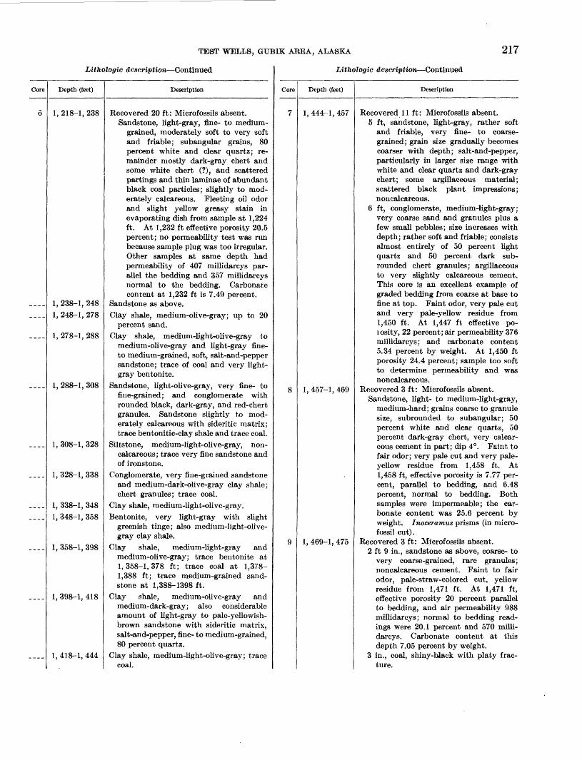
Recovered 17 ft: Microfossils very rare. 7 ft 9 in., sandstone, very light- to light-
gray, fine-grained, medium-hard, mas sive; mostly subangular grains, 85 percent white and clear quartz, also coal particles, dark chert, and a very small amount of pyrite and fluted opaque white volcanic glass shards. Matrix made up of soft light-colored bentonitic clay containing abundant brown biotite plates. Very slightly calcareous; dip undetermined; no shows. At 371 ft effective porosity 14.88 percent parallel to bedding and 14.93 percent normal to bedding. Samples impermeable.
7 ft 9 in., interbeded sandstone, 85 per cent, and clay shale. Sandstone same as described above. Clay shale is medium light to medium gray and medium hard; contains numerous particles of carbona ceous material and biotite plates, and occurs as laminae a few inches thick in the sandstone; laminae are irregular, lenticular, and have erratic dips with a slight tendency toward swirly bed ding in spots. A small piece of a thick-shelled Inoceramus cf. I. lund- breckensis McLearn found at 381 ft; dip 7° (?); noncalcareous; no shows.
11 in., clay shale, medium-light-gray, slightly silty; medium-soft, fair cleav age; part of the shale contains multi ple, small, elongated (flat and parallel to bedding) fragments of medium-gray clay; very rare carbonaceous partings.
7 in., limestone, medium-gray, argillace ous and medium hard; fractures paral lel to bedding; contains white crystal line calcite in a vein or fracture plane.
Sandstone, light-gray, and medium-grayclay shale.
Clay shale, medium-light to medium-gray; trace siltstone at 395-415 and 435-445 ft; trace white aragonite at 515-525 ft; mollusk shell fragment at 415-425 ft; chunk of thick Inoceramus prisms at 445-455 ft.
Sandstone, very light-gray, very fine grained; subangular grains, 90 percent white and clear quartz, also rock frag ments, dark chert, some volcanic shards; argillaceous bentonitic matrix.
Lithologic description -Continued
Core
____
____________
___ _____
_ _ _ -
2
_ ___
_ ___
_ - _ _
____
____
Depth (feet)
555-565565-575
575-585585-595595-605
605-655655-665
665-731
731-751
751-845
845-890
890-920
920-94&
940-950
Description
Siltstone, light-gray, bentonitic matrix.Siltstone, light-gray, and medium-light-
gray clay shale.Siltstone, light-gray, bentonitic matrix.Clay shale, very light-to light-gray, silty.Siltstone and very fine-grained sandstone;
considerable amount of biotite, bentonitic matrix.
Clay shale, medium-light-gray.Clay shale, medium-light-gray, and very
light-gray siltstone, with bentoniticmatrix.
Clay shale- medium- to medium-dark-gray;trace pyrite at 665-695 ft; trace light-gray siltstone at 705-71 5 and 725-735 ft;thick-shelled Inoceramus at 675-685 ft.
Recovered 20 ft: Microfossils abundant.10 ft 9 in., claystone, medium-gray,
slightly silty, hard; no cleavage butfractures roughly parallel to bedding;very rare light-gray bentonitic partings, but texture and color mostly uniform; rare vermicular pyritic streaks;noncalcareous; dip 1°.
7 in., bentonite, very light-gray, medium-soft when dry, irregular fracture.
2 ft 11 in., claystone, as above.2 in., bentonite, light-gray with slight
greenish cast.5 in., claystone as above.10 in., bentonite, ligbt-greenish-gray;
medium-soft when dry; fractureseasily.
4 ft 4 in., claystone, as in first part ofthis core.
Clay shale, medium-light- to medium-gray;trace of light-gray siltstone at 785-795and 815-825 ft.
Clay shale, medium-light- to medium-gray; rare round black-chert granulesnoted at 845 ft; trace siltstone at 865-875 ft.
Sandstone, light-gray, fine-grained, rathersoft; 95 percent white and clear quartz;rare rock fragments, chert; pyrite fairlycommon, slightly calcareous; matrixargillaceous but not bentonitic. Raremedium sand grains, and rare sub-rounded black-chert granules; 10 percentclay shale at base of sandstone. Topof the Tuluvak tongue of Prince Creekformation placed at 890 ft.
Clay shale, medium-gray; also fairly largeamount of very fine- to fine-grained light-gray sandstone, slightly to moderatelycalcareous.
Sandstone, light-gray, fine-grained; sub-angular grains, 90 percent white and

2lO EXPLORATION OF NAVAL PETROLEUM RESERVE NO. 4, ALASEA, 1944-53
Lithologic description Continued
Core
____
___-
____
____
3
.___
Depth (feet)
950-960
960-1, 060
1, 060-1, 070
1, 070-1, 086
1, 086-1, 106
1, 106-1, 155
Description
clear quartz; also dark chert and rockfragments; exceedingly rare very coarserounded dark-chert grains, pyrite verycommon; argillaceous matrix, slightlycalcareous.
Siltstone and very fine-grained sandstone,mediuno-light-gray
Clay shale, medium-gray and rare inedlum-light-gray; trace siltstone at 970-980 ft.
Coal, dull to subvitreous, black; platycleavage.
Clay shale, medium-gray; trace of medium-light-gray siltstone; about 10 ft of coal.
Recovered 20 ft: Microfossils absent.19 ft, sandstone, light-gray with very
light-gray streaks, medium-grained,hard, partly massive; 85 percent whiteand clear quartz; also some dark-graychert, rare coal grains; grains sub-angular; slightly to very calcareouscement. Very light-gray streaks represent laminae in which the calcareousmaterial is concentrated; very rare,thin partings of black carbonaceousmaterial. Slickensides of 17° and 30°noted at 1,100-1,101 ft. Beds dip asmuch as 15° in the vicinity of theseslickensides; dips elsewhere are variable, averaging about 6°. Faint odor,very pale cut and pale-yellow residuefrom 1,087 and 1,096 ft. At 1,087 ft,effective porosity 21.1 percent; airpermeability 166 millidarcys, and carbonate content, 9.3 percent by weight.At 1,096 ft the determinations parallelto bedding are as follows: 7.93 percent,impermeable, and 22.04 percent byweight. At 1,096 ft, normal to bedding, they are 7.88 percent and impermeable.
1 ft, conglomerate with matrix of sandstone of same type as described above.Pebbles and granules consist entirely ofblack chert and white quartz with aslightly larger proportion of theformer. They are well-rounded, andrange from % to J4 in. in diameter.Constituents of this conglomerate arewell sorted, primarily medium-sizedsand grains and pebbles of the sizementioned above, with very little ofintermediate grades. Cemented bycalcareous material.
Conglomerate and sandstone, light-gray,medium-grained; pebbles and some granules of black chert and white quartz,rounded; some of the sandy matrix iscoarse grained.
LitJioloffic description Continued
Core
4
5
_ __ _
_ ___
_ _ _ _
Depth (feet)
1, 155-1, 163
1, 163-1, 175
1, 175-1, 185
1, 185-1, 195
1, 195-1, 205
1, 205-1, 218
Description
Recovered 8 ft : Microfossils absent.8 in., coal, shiny to dull black, platy
cleavage.2 ft 7 in., clay shale, light-gray, medium
soft, very bentonitic; fair cleavage.Ac about 1,157 ft., 2 in. of shale impregnated with prismatic crystals ofwhite calcite or aragonite in laminaeparallel to bedding plane. Rest of theclay shale is noncalcareous and gradesdown into bentonite.
2 ft 9 in., bentonite, light-gray, argillaceous; similar to clay shale immediately above; contains minute brown-biotite plates.
2 ft, sandstone, medium-light-gray, veryfine- to fine-grained, very hard andtight; probably has siliceous ratherthan calcareous cement; mostly quartz;a few dark minerals including a littlebiotite; noncalcareous; dip 1°.
Recovered 12 ft: Microfossils absent.8 in., bentonite, very light-gray with
slight greenish cast; soft and crumblywhen dry; swells to unctuous masswhen moistened with water; containsnumerous biotite plates.
4 ft 10 in., sandstone, medium-light-gray,similar to sandstone of core 4 butsofter, very bentonitic, and containsmore biotite; grade? into clay shale inplaces; dip 5°.
2 ft, clay shale, medium-light-gray, faircleavage, medium-soft; contains streakof light-gray bentonite; noncalcareous; dip 3°.
1 ft 9 in., bentonite or very bentoniticclay, very light-gray, poor cleavage,with subconchoidal fracture; biotiteplates abundant.
2 ft 9 in., clay shale, medium- to medium-dark gray, noncalcareous, slightlybentonitic; fair cleavage.
Clay shale, medium- to medium-dark-gray;trace sandstone and clay ironstone.
Bentonite^ white, and very light-gray; verybentonitic clay shale; also medium-light-gray clay shale; trace yellowish-gray-clayironstone.
Clay shale, light-olive-gray, about a quarterof sample is subvitreous black coal; tracelight-gray bentonite.
Sandstone, medium-light-gray, medium-grained, rather soft and friable; salt-and-pepper, noncalcareous; 80 percent whiteand clear quartz; rest dark chert androck fragments, coal particles, whitechalky material, rare biotite. Also tracecoal and medium-dark-gray clay shale.
TEST WELLS, GUBIK AREA, ALASKA 217
Lithologic description Continued
Core
6
____
____
____
____
____
_ __ _
____
____
_ __ _
___ _
____
Depth (feet)
1, 218-1, 238
1, 238-1, 248
1, 248-1, 278
1, 278-1, 288
1, 288-1, 308
1, 308-1, 328
1, 328-1, 338
1, 338-1, 348
1, 348-1, 358
1, 358-1, 398
1,398-1,418
1, 418-1, 444
Description
Recovered 20 ft: Microfossils absent.Sandstone, light-gray, fine- to medium-
grained, moderately soft to very softand friable; subangular grains, 80percent white and clear quartz; remainder mostly dark-gray chert andsome white chert (?), and scatteredpartings and thin laminae of abundantblack coal particles; slightly to moderately calcareous. Fleeting oil odorand slight yellow greasy stain inevaporating dish from sample at 1,224ft. At 1,232 ft effective porosity 20.5percent; no permeability test was runbecause sample plug was too irregular.Other samples at same depth hadpermeability of 407 millidarcys parallel the bedding and 357 millidarcysnormal to the bedding. Carbonatecontent at 1,232 ft is 7.49 percent.
Sandstone as above.
Clay shale, medium-olive-gray; up to 20percent sand.
Clay shale, medium-light-olive-gray tomedium-olive-gray and light-gray fine-to medium-grained, soft, salt-and-peppersandstone; trace of coal and very light-gray bentonite.
Sandstone, light-olive-gray, very fine- tofine-grained; and conglomerate withrounded black, dark-gray, and red-chertgranules. Sandstone slightly to moderately calcareous with sideritic matrix;trace bentonitic-clay shale and trace coal.
Siltstone, medium-light-olive-gray, non-calcareous; trace very fine sandstone andof ironstone.
Conglomerate, very fine-grained sandstoneand medium-dark-olive-gray clay shale;chert granules; trace coal.
Clay shale, medium-light-olive-gray.
Bentonite, very light-gray with slightgreenish tinge; also medium-light-olive-gray clay shale.
Clay shale, medium-light-gray andmedium-olive-gray; trace bentonite at1, 358-1, 378 ft; trace coal at 1,378-1,388 ft; trace medium-grained sandstone at 1,388-1398 ft.
Clay shale, medium-olive-gray andmedium-dark-gray; also considerableamount of light-gray to pale-yellowish-brown sandstone with sideritic matrix,salt-and-pepper, fine- to medium-grained,80 percent quartz.
Clay shale, medium-light-olive-gray; tracecoal.
Lithologic description Continued
Core Depth (feet)
1, 444-1, 457
1, 457-1, 469
1, 469-1, 475
Description
Recovered 11 ft: Microfossils absent.5 ft, sandstone, light-gray, rather soft
and friable, very fine- to coarse grained; grain size gradually becomes coarser with depth; salt-and-pepper, particularly in larger size range with white and clear quartz and dark-gray chert; some argillaceous material; scattered black plant impressions; noncalcareous.
6 ft, conglomerate, medium-light-gray; very coarse sand and granules plus a few small pebbles; size increases with depth; rather soft and friable; consists almost entirely of 50 percent light quartz and 50 percent dark sub- rounded chert granules; argillaceous to very slightly calcareous cement. This core is an excellent example of graded bedding from coarse at base to fine at top. Faint odor, very pale cut and very pale-yellow residue from 1,450 ft. At 1,447 ft effective po- losity, 22 percent; air permeability 376 millidarcys; and carbonate content 5.34 percent by weight. At 1,450 ft porosity 24.4 percent; sample too soft to determine permeability and was noncalcareous.
Recovered 3 ft: Microf ossils absent.Sandstone, light- to medium-light-gray,
medium-hard; grains coarse to granule size, subrounded to subangular; 50 percent white and clear quartz, 50 percent dark-gray chert, very calcar eous cement in part; dip 4°. Faint to fair odor; very pale cut and very pale- yellow residue from 1,458 ft. At 1,458 ft, effective porosity is 7.77 per cent, parallel to bedding, and 6.48 percent, normal to bedding. Both samples were impermeable; the car bonate content was 25.6 percent by weight. Inoceramus prisms (in micro- fossil cut).
Recovered 3 ft: Microf ossils absent.2 ft 9 in., sandstone as above, coarse- to
very coarse-grained, rare granules; noncalcareous cement. Faint to fair odor, pale-straw-colored cut, yellow residue from 1,471 ft. At 1,471 ft, effective porosity 20 percent parallel to bedding, and air permeability 988 millidarcys; normal to bedding read ings were 20.1 percent and 570 milli darcys. Carbonate content at this depth 7.05 percent by weight.
3 in., coal, shiny-black with platy frac ture.

218 EXPLORATION OF NAVAL PETROLEUM RESERVE NO. 4, ALASKA, 1944-53
Lithologic description Continued
Core
10
-
____
___-
____
Depth (feet)
1,475-1,495
1, 495-1, 525
1, 525-1, 535
1, 535-1, 545
1, 545-1, 555
1, 555-1, 585
1, 585-1, 645
Description
Recovered 20 ft: Microfossils absent.5 ft, clay shale, medium-gray to dark-
gray, medium-hard; poor cleavage;scattered lighter colored silty streaks;dark color of some portions is due toabundance of finely disseminatedcarbonaceous material and a few blackplant impressions.
2 ft, sandstone, light-gray, as describedin lowest segment of this core; rareplant impressions. Slight petroliferous odor.
3 ft 4 in., clay shale as in first part ofthis core. The plant Credneria elegansHollick found at 1,484 ft.
9 ft 8 in., sandstone, light-gray, medium-grained, hard, massive, irregular fracture ; salt-and-pepper with light quartzand dark chert; other minerals rare;slightly calcareous cement; dip undetermined. Faint to fair odor, pale-straw-colored cut and pale-yellowresidue from 1,491 ft. At 1,491 fteffective porosity 16,37 percent and airpermeability 19 millidarcys parallel tobedding. Normal to bedding readingsare 14.85 percent and 13 millidarcys.Carbonate content 13.9 percent byweight.
Sandstone, light- to medium-light-gray, fine-grained, very porous, noncalcareous;mostly white and clear quartz grainswith rare chert granules; conglomeraticfrom 1,505-1,515 ft with very coarsesand, and subangular to rounded granules of black chert, yellow chert, and white quartz.
Clay shale, very light-gray, bentonitic, andwhite bentonite.
Sandstone, light-gray, fine-grained; 90percent white and clear quartz grains;slightly calcareous; 5 percent of thissample is coal.
Clay shale, dark-gray, and 20 percent coal.
Coal, dull to subvitreous, black, flaky,some dark-gray siltstone, and trace medium-grained dark-gray sandstone at1,555-1,565 ft; trace light-gray finegrained sandstone and medium-dark-gray clay shale at 1,575-1,585 ft.
Sandstone, light-gray, very fine- to verycoarse-grained; 60 percent white andclear quartz grains, 30 percent dark-graychert and coal particles; the grainssubangular to subrounded, largest areroundest; noncalcareous, very soft, friable and porous. Trace coal at 1,605-1,615 and 1,625-1,635 ft.
Lithologic description Continued
Core
___-.
_ __ _
11
_ __ _
12
Depth (feet)
1, 645-1, 655
1, 655-1, 665
1,665-1,711
1,711-1,718
1,711-1,723
1, 723-1, 738
Description
Sandstone as above, 20 percent dull tosubvitreous black coal and 15 percentwhite bentonite; trace medium-gray clayshale.
Clay shale, medium-dark-gray; trace sandstone.
Sandstone, light-gray, fine- to very coarsegrained; fine grains mostly white quartz,as much as 50 percent dark chert insample at 1,685-1,695 ft.
Recovered 7 ft: Microfossils absent.1 ft 3 in., sandstone, light-gray, con
glomerate, medium-soft and friable.The sand grains are medium-sized andsubangular; 80 percent white and clearquartz grains; some mica, coal particles, and dark chert; sandstone contains angular fragments of shiny-blackcoal as much as 2 in. in diameter, rarerounded black-chert pebbles and angular medium-gray clay fragments; argillaceous cement; noncalcareous. At1,712 ft, effective porosity 29 percent,but sample was too soft for permeability tests. Kerosenelike odor, yellowcut, and brownish-yellow residue from1,712 ft.
4 ft 11 in., clay shale, dark-gray, medium-hard; good cleavage; dark colorapparently due to finely disseminated carbonaceous material; also minuteflakes of mica, some pyrite; verticalfracture; contains rare thin laminae ofpale-yellowish-brown clay ironstoneand very rare fishbone fragments;noncalcareous. Slickensides at base; dip of beds just above slickensides 25°;dip at top of 8°.
10 in., sandstone, light-gray; similar tofirst unit of this core, with scatteredpebbles of black chert only; non-calcareous; dip 30°; petroliferous odor.Inoceramus prisms in microfossil cut.
Sandstone, fine- to coarse-grained, also 20percent coal.
Recovered 11 ft: Microfossils absent.Sandstone, light-gray, fine- to rarely
medium-grained, hard, massive; grains subrounded to angular, 95 percentwhite and clear quartz; some mica,coal, and dark chert; rock has slightyellowish stain in spots; noncalcareous; dip 1°. At 1,730 ft parallelto bedding, effective porosity 19.55percent, and air permeability 39millidarcys. It is 18.7 percent and8 millidarcys normal to bedding.Kerosenelike odor, yellow cut, andbrownish-yellow residue from 1,730 ft.Inoceramus prisms in microfossil cut.

TEST WELLS, GUBIK AEEA, ALASKA. 219
description Continued
Core
____
________
____
____
13
14
____
___ _
Depth (feet)
1, 738-1, 760
1, 760-1, 770
1, 770-1, 7901, 790-1, 830
1, 830-1, 840
1, 840-1, 856
1, 856-1, 877
1, 877-1, 897
1,897-1,970
1, 970-1, 980
1, 980-2, 040
Description
Sandstone, medium-light-gray, fine- tocoarse-grained, very soft; 95 percentwhite and clear quartz grains, with biotite and coal particles; noncalcareous.Trace coal and dark-gray clay shale.
Siltstone, medium-light-gray, and light-gray sandstone; contains biotite; moderately to very calcareous. Top of Sea-bee formation placed at 1,760 ft.
No sample.Clay shale, medium-light-gray; trace sand
stone at 1,800-1,810 ft; trace coal at1,810-1,820 ft.
Clay shale, medium-light-gray, and approximately 40 percent very calcareoussandstone.
Sandstone, medium-light-gray, fine-grained,porous, very soft; grains subrounded tosubangular, mostly white arid clearquartz, some chert and biotite; slightlycalcareous.
Recovered 10 ft: Microfossils absent.3 ft, sandstone, light-gray, fine-grained,
slightly calcareous, medium-soft; excellent cleavage parallel to bedding;subangular grains composed of 70 percent white and clear quartz; biotiteand chlorite common; dark chert androck fragments also present; dip 1° orless.
7 ft, sandstone and siltstone, light-gray,medium-soft; of same composition asabove; no cleavage. This part ofrecovery is broken into pieces averaging about 2 in. in diameter. Slightlycalcareous.
Recovered 10 ft: Microfossils absent.Siltstone and sandstone, light-gray with
fairly good cleavage in part; sandstonevery fine-grained and 50 percentquartz. Biotite and other mica minerals extremely abundant; coal particles also present; some dark-carbonaceous partings; slightly calcareous; dip 1°.
Clay shale, medium-light-gray, micaceous;contains traces of sandstone and silt-stone throughout.
Sandstone, medium-light-gray, fine- tomedium-grained; angular to subangulargrains, 85 percent white and clear quartz,15 percent dark-gray to black chert(salt-and-pepper), very small amount ofyellow quartz; trace medium-gray clayshale.
Clay shale, medium-light-gray trace veryfine-grained sandstone and siltstone at2,000-2,040 ft; sandstone slightly tomoderately calcareous at 2,010-2,020 ft.
Lithotoffic description Continued
Core
15
16
Depth (feet)
2, 040-2, 050
2, 050-2, 185
2, 185-2, 200
2, 200-2, 250
2, 250-2, 400
2, 400-2, 420
2, 420-2, 450
2, 450-2, 480 2, 480-2, 499 2, 499-2, 519
2, 519-2, 610
Description
Clay shale, medium-light to medium-gray about 40 percent light-gray very fine- to fine-grained sandstone; contains scat tered biotite and coal particles and is slightly calcareous; trace very light-gray bentonite with biotite plates.
Clay shale, medium-gray. Trace sand stone at 2,130-2,150 ft and 2,160-2,180 ft. Trace siltstone at 2,060-2,070 ft, 2,080-2,130 ft (moderately calcareous at 2,110-2,130 ft), and 2,150-2,160 ft. Trace to 10 percent bentonite or ben- tonitic clay, light gray at 2,080-2,090 ft, 2,110-2,120 ft and 2,150-2,160 ft. Trace coal at 2,070-2,080 ft.
Recovered 10 ft: Microfossils absent. Clay shale, medium-gray, noncalcareous,
medium-hard, fair to good cleavage with subconchoidal fracture; lighter colored silty laminae which show small scale crossbedding; very rare scattered brown fish fragments noted; dip 0.5°.
Clay shale, medium-gray. Trace siltstone and very fine-grained sandstone at 2,200-2,220 ft and 2,230-2,240 ft.
Clay shale, medium- to medium-dark- gray; chunk Inoceramus prisms at 2,290-2,300 ft; trace very fine-grained sandstone at 2,300-2,310, 2,340-2,350, and 2,360-2,370 ft; 5 percent slightly calcareous siltstone, contains biotite, at 2,320-2,330 ft, trace siltstone at 2,330-2,350 ft, trace light-gray clay shale at 2,390-2,400 ft.
Silty clay shale, medium-light- to medium- gray.
Siltstone, medium-light-gray, noncalcar eous; also medium-gray clay shale.
Clay shale, medium-gray; trace siltstone. Clay shale, medium- to medium-dark-gray. Recovered 20 ft: Microfossils absent.
Clay shale, medium-gray, medium-hard, with good cleavage, thin-bedded with light-colored silty laminae. Pelecypod fragments at 2,506, 2,510, 2,511, and 2,515 ft. Three of these are a thin- shelled Inoceramus, cf. I. labiatus Schlotheim of the Seabee formation. Brown fishbone fragments rare; non- calcareous; dip \%° in upper part of core, uniformly increasing to 43° at 2,513 ft where steep slickensides were noted, decreases to 9° at base.
Clay shale, medium-gray; 10 percent medium-light-gray siltstone, moderately calcareous; chunk Inoceramus prisms at at 2,520-2,530 ft. Trace very calcareous siltstone at 2,540-2,550 ft; also trace aragonite and trace coal at 2,600-2,610 ft.
429370 58

220 EXPLORATION OF NAVAL PETROLETJM:RESERVE NO. 4, ALSAKA, 1944-53
LitholQffic description Continued
Core
17
18
----
____
- ., --.
----
19
Depth (feet)
2, 610-2, 620
2, 620-2, 639
2, 639-2, 659
2, 659-2, 670
2, 670-2, 680
2, 680-2, 690
2, 690-2, 700
2, 700-2, 723
2, 723-2, 743
Description
Siltstone, light-gray, also about 40 percentclay shale, trace coal.
Recovered 10 ft: Microfossils absent.Clay shale, medium-gray, medium-hard,
noncalcareous, with good cleavage; approximately 10 percent medium-light-gray siltstone in very thin laminae andlenses in shale. Inoceramus shell fragment noted at 2,638 ft. Fish fragmentsvery rare; dip less than 1°.
Recovered 19 ft: Microfossils absent.Clay shale as above but with approxi
mately 15 percent siltstone; some sub-conchoidal fracture; poor to good cleavage; parts of lowest 8 ft of core havegood poker-chip cleavage and areslightly softer than rest of core.Inoceramus found at 2,649 and 2,655ft; shale noncalcareous; dip less than1°.
Clay shale, medium-gray; trace siltstone, chunks of Inoceramus prisms.
Clay shale, medium- to medium-dark-gray; trace light-gray clay shale; trace silt-stone.
Clay shale, medium-gray; 20 percent ofsample light-gray moderately calcareoussiltstone.
Clay shale, medium-gray; trace finegrained slightly calcareous sandstone;trace ironstone.
Clay shale, medium-gray and dark-gray;25 percent light-gray dirty micaceous slightly calcareous sandstone.
Recovered 19 ft: Microfossils absent.Interbedded sandstone, 92 percent, and
clay shale, 8 percent. Sandstone lightgray, hard, very fine to mediumgrained; moderately to very calcareous;subangular grains, 85 percent whiteand clear quartz. Ten percent darkchert and rock fragments and approximately 5 percent fairly large biotiteplates speckled throughout. Clayshale is medium to medium darkgray, hard, and interbedded in thinlaminae with sandstone. In part ofcore sand and clay show well gradedbeds, each cycle about 2 in. thick.Carbonate content at 2,739 ft 15.4percent by weight. Dip \%°. Noshows. All samples in following tableimpermeable to air.
Litholoffio description Continued
Core
____
_ _ _ _
----
____
20
____
____
!____
Depth (feet)
2, 743-2, 760
2, 760-2, 770
2, 770-2, 780
2, 780-2, 810
2, 810-2, 820
2, 820-2, 830
2, 830-2, 840
2, 840-2, 860
2, 860-2, 910
2, 910-2, 930
2, 930-2, 940
2, 940-2, 954
Description
»
Carbon-Effective ate con-
Depth (feet) porosity tent (per-(percent) cent by
weight)
2,725 parallel.. - 10.31 7.62,725 normal------------------ 9.53 ------------2,739parallel ----------- 10.70 15.42,739 normal ----------- 9.62 .... __ ...
Sandstone, light-gray, fine-grained withsome medium grains; grains subangular,60 percent white and clear quarts, remainder mostly dark chert, coal fragments, and biotite; moderately to verycalcareous. Also some clay shale,medium-dark-gray.
Clay shale, medium to medium-dark-gray,and 15 percent sandstone as above.
Clay shale, medium-gray; approximately30 percent of sample is light-gray fine grained and silty only very slightly calcareous sandstone.
Clay shale, medium- to medium-dark-gray; slightly silty at 2,790-2,800 ft.
Bentonite, white, and medium -dark-grayclay shale.
Clay shale, medium-gray, very smallamount of white aragonite.
Clay shale, medium-dark-gray; trace whitebentonite.
Recovered 7 ft: Microfossils absent.Clay shale, medium-gray, hard, fair
to good cleavage; scattered verylight-gray bentonitic partings; 2 in. bentonite at very top of core is lightgray and rather hard when dry andcontains numerous plates of brownbiotite. About 1*4 ft from bottomis 6 in. of light-bluish-gray bentonite, laced throughout with veins ofwhite prismatic aragonite or calcite;dip 2°.
Siltstone, medium-light-gray; small amountof white-vein calcite or aragonite. Tracevery light-gray bentonitic clay, 2,890-2,900 ft. Rare Inoceramus prisms 2, 870-2,880 and 2,900-2,910 ft.
Clay shale, medium-gray and some silt-stone.
Sandstone, light-gray, fine-grained; grainssubangular to subrounded, 85 percentwhite and clear quartz, also dark chert;very calcareous.
Clay shale, 40 percent, medium-dark-

TEST WELLS, GUBIK ABBA, ALASKA 221
Lithologic description Continued
Core Depth (feet)
21 2, 954-2, 974
22
2. 974-3, 000
3. 000-3, 040
3, 040-3, 051
3, 051-3, 070
3, 070-3, 090
3, 090-3, 100 3, 100-3, 120 3, 120-3, 130
3, 130-3, 150
Description
gray, and 40 percent medium-light-gray siltstone, rest light-gray very calcareous' sandstone with trace bluish-gray clay shale. '
Recovered 15 ft: Microfossils rare.5 ft, siltstone, 90 percent, very argil-;
laceous, and silty clay shale. Color 1 varies from light to medium gray. The central part shows an excellent' pattern of slump or swirly bedding., Impression of a small pelecypod at very top of unit. Siltstone slightly calcareous.
10 ft, clay shale, medium-gray, hard, with fair cleavage; interbedded with; approximately 6 percent irregular laminae and lenses of medium-light- gray siltstone. Carbonaceous frag ments rare; beds very nearly flat lying; a sma)l unidentified pelecypod at 2,962 ft. Inoceramus prisms in microfossil cut.
Sandstone, medium-light-gray, very fine grained, and siltstone; noncalcareous, also some medium-gray clay shale. Inoceramus fragments and prisms at 2,970-2,980 and 2,990-3,000 ft.
Siltstone, medium-light-olive-gray, and asmuch as 50 percent silty clay shale.
Clay shale, medium-gray, silty, and smallamount of siltstone.
Recovered 5 ft: Microfossils rare.Siltstone and claystone, all gradations
between these two "types but pre dominantly medium-light- to medi um-gray hard siltstone with irregular fracture; micaceous; scattered dark carbonaceous fragments; fractured Ino ceramus embedded vertically through out bottom foot of recovery. Non- calcareous; beds approximately flat lying.
Sandstone, light-gray, fine-grained, rather soft, noncalcareous; subangular to sub- rounded grains, 90 percent white and clear quartz; remainder mostly dark chert; biotite fairly common; very rare Inoceramus prisms. Trace medium-gray clay shale.
Sandstone and siltstone. No sample.Siltstone, medium-light-gray; trace medi
um-dark-gray silty limestone. Sandstone, light-gray, fine-grained, very
slightly calcareous; 90 percent white and clear quartz grains, also dark chert, rock and coal particles, fairly common biotite; very rare Inoceramus prisms.
Lithologic description Continued
Core
23.__-
_ __ _
24
Depth (feet)
3, 150-3, 169
3, 169-3, 1863, 186-3, 200
3, 200-3, 220
3, 220-3, 230
3, 230-3, 240
3, 240-3, 261
3, 261-3, 281
3, 281-3, 342
Description
Siltstone, medium-light-gray, noncalcareous. Trace medium-gray clay shale.
No recovery.Sandstone, light-gray, very fine-grained,
silty, noncalcareous. Trace silty clayshale; Inoceramus prisms fairly commonat 3,186-3,190 ft.
Siltstone, medium-light-gray; biotiteS verycommon.
Sandstone, light-gray, noncalcareous, soft;grains subangular to subrounded, 90 percent white and clear quartz; rest darkchert and coal particles; biotite not socommon.
Clay shale, medium-dark gray; 40 percentmedium-light-gray siltstone.
Sandstone and siltstone; sandstone moderately calcareous; some clay shale; onechunk of Inoceramus prisms 3,250-3,260ft.
Recovered 19 ft: Microfossils absent.7 ft. 6 in., interbedded sandstone, 60
percent, siltstone, 25 percenl , and clayshale, 15 percent. Sandstone is lightgray, fine to medium grained, hard;60 percent white and clear quartz; restmostly dark chert and coal particles;chloritoid and glaucophane noted;very calcareous cement. Siltstonesimilar to sandstone but medium lightgray. Clay shale is medium darkgray, hard, good cleavage. Sandstoneand siltstone contain rare gray ironstone nodules; certain sections containrare small fragments of clay shaleparallel to bedding; coaly, carbonaceous partings present; moderately tovery calcareous; dip low but some indication of cross bedding with dips inthe siltstone as much as 27°; faintpetroliferous odor, very pale cut andyellowish greasy stain in evaporatingdish at 3,266 ft. At 3,266 ft effectiveporosity 7.96 percent parallel to bedding, and 9.8 percent normal to bedding. Both sample plugs impermeable.
11 ft 6 in., clay shale, siltstone, and allgradations, very thin beds. Clayshale is medium gray, and siltstone ismedium light gray. Fair cleavage;moderately hard; moderately to verycalcareous; dip %°.
Clay shale, medium-dark-gray; one chunkInoceramus prisms 3,290-3,300 ft. Traceto 10 percent siltstone at 3,310-3,340 ft.Top of Chandler and Ninuluk formationsundifferentiated placed at 3,305 ft.

222 EXPLORATION OF NAVAL PETROLEUM RESERVE NO. 4, ALASKA, 1944-53
lAthoWgic description Continued
Core
25
26
Depth (feet)
3, 342-3, 362
3, 362-3, 370
3, 370-3, 380 3, 380-3, 390
3, 390-3, 400
3, 400-3, 410
3, 410-3, 420 3, 420-3, 435 3, 435-3, 455
Description
Recovered 19 ft: Microfossils abundant. 3 ft, clay shale, medium-dark-gray, very
slightly micaceous, medium-hard, with rare carbonaceous fragments; fair cleavage, and some subconchoidal fracture.
5 ft 10 in., siltstone and silty cla> shale, medium-light-gray, hard, with rare slightly sandy streaks. Part of the siltstone occurs as lenses in silty clay shale; rare carbonaceous partings; beds approximately flat lying. A 6-in. segment between siltstone and under lying sandstone marked by rare small rounded black-chert pebbles.
10 ft 2 in., sandstone, light-gray, fine grained, silty, noncalcareous, tight, massive, hard; grains subrounded to subangular; 90 percent white and clear quartz; rest mostly dark chert and rare coal particles plus mica. Un identified pelecypods (two types) as much as 1 in. in diameter preserved as brownish-coated casts at 3,356 and 3,362 ft. A pelecypod found at 3,360 ft is Arctica sp. Faint odor, no cut, greasy stain in evaporating dish at 3,361 ft. At 3,361 ft effective porosity 10.75 percent parallel to bedding and 10.54 percent normal to bedding. Both samples impermeable.
Sandstone, light-gray, fine-grained; sub- angular to subrounded grains, 85 per cent white and clear quartz; rest dark chert, carbonaceous particles, and com mon biotite.
No sample. Clay shale, medium-light-gray, very rare
chips of coal. Sandstone, light-gray, and siltstone; 20
percent medium-light-gray clay shale. Siltstone, medium-light-gray, very slightly
calcareous. Trace very fine-grained sandstone and clay shale.
No sample.Siltstone and trace of silty clay shale. Recovered 20 ft: Microfossils absent.
Siltstone, medium-light-gray, hard, with fair cleavage parallel to bedding; scattered streaks of medium-dark- gray clay shale and very fine-grained sandstone, carbonaceous partings; rare light-yellowish-gray clay ironstone nodules; slightly calcareous to non- calcareous; dip 1°, irregularities of some beds suggest small-scale local deformation at time of deposition by slumping and (or) current action. No shows.
Lithotogic description Continued
Core
27
28
Depth (feet)
3, 455-3, 466
3, 466-3, 485
3, 485-3, 502
Description
Recovered 11 ft: Microfossils absent. 7 ft., siltstone as described in core im
mediately above; rare laminae of medium-dark-gray slightly carbona ceous clay shale. Siltstone grades downward into sandstone.
3 ft. 9 in., sandstone, light-gray, very fine- to fine-grained, massive, hard; irregular fracture: grains 85 percent white and clear quartz; rest dark chert, mica, and coaly particles. Carbonate content at 3,464 ft 8.64 percent by weight; dip 2°; no ir regular bedding. Fair petroliferous odor, very pale cut and yellowish greasy stain in evaporating dish at 3,464 ft. At 3,464 ft effective po rosity 10.24 percent parallel to bedding and 10.46 percent normal to bedding. Both samples impermeable; carbonate content at that depth 8.24 percent by weight.
3 in., clay shale, medium-dark-gray, hard, with fair cleavage and numerous carbonaceous and micaceous particles.
Sandstone, light-gray, fine-grained, non- calcareous; grains subangular to sub- rounded, 85 percent white and clear quartz; rest dark chert, coal particles, and mica; probably has carbonaceous partings. Trace ironstone at 3,480- 3,485 ft.
Recovered 17 ft: Microfossils absent. Sandstone, light- to medium-light-gray,
fine-grained, silty, massive, hard, tight, subangular to subrouiided grains 85 percent white and clear quartz; remainder coal particles and dark chert; mica rarely common; argil laceous matrix, very rare brownish- gray clay-ironstone nodules in lowest 3 ft core. Beds approximately flat lying; faint odor, very pale cut, and greasy stain from 3,489 ft and very faint odor, no cut, and greasy stain from 3,500 ft. Following porosity and permeability determinations were made:
Depth (feet)
3,489 parallel. 3,489 normal.. 3,500 parallel. 3,500 normal..
Effec tive po rosity
(percent)
9.569.44
11.5210.02
Airpermea bility (mffli-
dareys)
Carbon ate con
tent (percent
by weight)
4.34

TEST WELLS, GUBIK AREA, ALASKA 223
Lithologic description Continued
Core Depth (feet)
29 3, 502-3, 519
30 3, 519-3, 535
31 3, 535-3, 555
Description
Recovered 17 ft: Microfossils absent. Sandstone, light-gray, fine- to medium-
grained, medium-hard, breaks parallel to bedding; subangular to subrounded grains (mostly subangular); 85 percent white and clear quartz; rest mostly black-coal particles and dark-gray chert. Sandstone is slightly softer and more porous than that above; bedding poorly defined but probably approximately flat lying, fair to good sour crude-oil odor, straw-colored cut and yellow residue from 3,503 and 3,518 ft. Following porosity and per meabilities were determined:
Depth (feet)
3,503 parallel. 3,503 normal.. 3,518 parallel. 3,518 normal-
Effec tive po rosity
(percent)
15.1415.1513.7413.35
Airpermea
bility (milli-
darcys)
265704335
Carbon ate con
tent (percent
by weight)
1.86
5.77
Recovered 16 ft: Microfossils absent. Sandstone, light-gray; essentially same
as that in core 29 but very fine to fine grained and slightly harder and tighter particularly toward base. Car bonate content 6.57 percent by weight at 3,522 ft and 6.12 percent at 3,532 ft; beds approximately flat lying; no odor or cut but yellowish greasy stain in evaporating dish at 3,523 and 3,532 ft. Porosity and permeability deter mined as follows:
Depth (feet)
3,522 parallel. 3,522 normal.. 3,532 parallel. 3,532 normal-
Effec tive po rosity
(percent)
11.0512.9412.2011.94
Airpermea bility (milli-
darcys)
15.015.03.1
Carbon ate con
tent (percent
by weight)
6.57
6.12
Recovered 20 ft: Microfossils absent. Sandstone, light-gray, fine-grained, hard,
massive; has irregular fracture approx imately at right angles to side of core; subangular to subrounded grains, 90 percent white and clear quartz; rest dark chert, coal particles, rare mica, and rare chalky white weathered chert particles; a few laminae have a larger proportion of dark minerals. Bedding obscure but beds probably flat lying.
Lithologic description Continued
Core
32
33
Depth (feet)
3, 555-3, 567
3, 567-3, 586
Description
No odor or cut but a greasy film as residue in evaporating dish at 3,542 and 3,548 ft. Porosity and perme ability determinations made at same depths:
Depth (feet)
3,542 parallel.. 3,542 normal.- 3,548 parallel.. 3,548 normal..
Effec- tive po rosity
(percent)
13.1113.3414.1013.10
Airpermea bility (milli-
darcys)
29.020.027.018.5
Carbon ate con
tent (percent
byweight)
5.67
Recovered 12 ft: Microfossils absent.Sandstone, light- to medium-light-gray,
very fine- to fine-grained, hard, mas sive ; tighter than in core above; grains subangular to subrounded; most con stituents as in core above. Quartz, 85 percent; rare dark carbonaceous-mica ceous partings; very rare slightly yel lowish-gray ironstone concretions; a few thin medium-gray clay shale lam inae in last iy2 ft of core; essentially noncalcareous. Beds flat lying; no odor or cut, but a greasy film residue in evaporating dish, at 3,559 ft. At 3,559 ft effective porosity 13.65 per cent parallel to bedding and 13.32 per cent normal to bedding; air permea bility 32 and 24 millidarcys respec tively, and carbonate content 7.5 percent by weight.
Recovered 19 ft: Microfossils absent.3 ft, sandstone, light-gray, massive,
hard, same constituents as above but more argillaceous material; noncal careous; beds flat lying.
16 ft, sandstone, light-gray, fine- to medium-grained, noncalcareous to slightly calcareous, medium-hard; has tendency to fracture roughly parallel to bedding giving a pseudo poker- chip effect; 75 percent white and clear quartz grains; rock fragments and dark chert, 15 percent (salt-and-pepper) in part); rest is white weathered chert, mica, garnet, and a small amount of other minerals; very rare coaly part ings; beds approximately flat lying. Faint odor, no cut, greasy film from 3,571 ft and faint odor, very pale cut, and greasy film from 3,580 ft. Follow ing porosity and permeability deter minations made:

224 EXPLORATION OF NAVAL PETROLEUM RESERVE NO. 4, ALASKA, 1944-53
LitholOffic description Continued
Core
34
35
Depth (feet)
3, 586-3, 602
3, 602-3, 608
3, 608-3, 623
3, 623-3, 633
3, 633-3, 643
3, 643-3, 653
Description
Depth (feet)
3,571 parallel. ...
3,580..-----. ._
Effective porosity
(percent)
11.9011.3812.30
Airpermeability (milli-
darcys)
8.5.. ........... .<1 .... ... ....
able.
Carbonate con
tent (percent
byweight)
7.41
11.60
Recovered 15 ft: Microfossils absent. Sandstone, light-gray, fine-grained,
/slightly calcareous to noncalcareous, hard, massive; not as soft and does not have the distinctive fracture as in core above; grains subangular to sub- rounded, 85 percent white and clear quartz; rest is dark chert, rock frag ments, weathered white chert, biotite (quite common), and very rare car bonaceous partings. Becomes finer grained toward the base; dip 1°. Fair to good kerosenelike odor, pale-straw- colored cut and yellow residue from 3,594 and 3,598 ft. All samples in the following table were impermeable to air.
Depth (feet)
3,594 parallel. 3,594 normal.. 3,598 parallel. 3,598 normal..
Effective porosity (percent)
11.1010.7510.2010.45
Carbon ate con tent (per cent by weight)
18.45
15.10
Recovered 4 ft: Microfossils absent.Sandstone, medium-light-gray, very fine-
to fine-grained, very calcareous, very hard; irregular fracture; constituents similar to above; biotite quite com mon; nearly a sandy limestone. Dip 1°; no shows. Carbonate content at 3,603 ft 38.3 percent.
Sandstone, light-gray, very fine- to fine grained; 85 percent white and clear quartz; grains subangular to subrounded; also dark-gray chert, coal particles, and biotite. Very calcareous but softer and noncalcareous in bottom 10 ft. Trace medium-dark-gray clay shale.
Siltstone, medium-light-gray, and slightlycalcareous sandstone.
Clay shale, medium- to medium-dark-gray; 20 percent siltstone; trace subvitreous black coal.
Siltstone, medium-light-gray, argillaceous, slightly calcareous, and medium-gray clay shale; trace coal.
Lithologic description Continued
Core
36
37
38
Depth (feet)
3, 653-3, 663
3, 663-3, 680
3, 680-3, 685 3, 685-3, 702
3, 702-3, 707
3, 707-3, 735
3, 735-3, 762
3, 762-3, 782
3, 782-3, 783
3, 783-3, 795
3, 795-3, 810
3, 810-3, 820
Description
Siltstone, medium-light-gray, argillaceous; rare pebbles, granules and very coarse grains of rounded black chert. Also 30 percent very light-gray bentonite.
Siltstone, medium-light-gray, noncal careous, and trace to 10 percent light- gray fine-grained very calcareous sand stone.
Sandstone, very fine-grained, and siltstone. Siltstone, medium-light-gray, argillaceous,
and some soft light-gray clay 3,790- 3,795 ft. (nonbentonitic).
Recovered 1 ft: Microfossils absent.Clay shale, medium-light-gray, noncal
careous, medium-hard, with good cleavage; very thin silty laminae; me dium-gray slightly micaceous-carbo naceous partings; dip 2°.
Clay shale, medium-gray; trace of siltstone 3,710-3,715 ft and 3,730-3,735 ft; trace coal at 3,710-3,715 ft.
Siltstone, medium-gray- very fine-grained; sand streaks toward base; as much as 40 percent medium- to medium-dark- gray clay shale. Top of Grandstand formation placed at 3,735 ft.
Recovered 20 ft: Microfossils absent. 14 ft, claystone, medium-light- to
medium-gray, hard, incipient or no cleavage; contains much micaceous and some carbonaceous material; silty toward base. Suggestion of swirly bedding at 3,770 ft, slickensides of 50° at 3,770^ ft; slightly calcareous; dips reach a maximum of 6°.
6 ft, clay shale and siltstone, medium- light- to medium-gray, very silty; essentially as in upper part of this core, but with slightly better cleavage and with better defined alternation of silty and clayey beds. Silty layers slightly calcareous.
Recovered 1 ft: Microfossils absent.Siltstone, medium-light- to medium-gray,
hard, has poor cleavage; micaceous- argillaceous partings and laminae; slightly calcareous. Maximum dips of 10° suggest crossbedding. No shows.
Siltstone, medium-light-gray, sandy, and 20 percent medium- to medium-dark- gray clay shale.
Silty clay shale, medium-gray; trace coal and trace white vein aragonite or calcite.
Sandstone, light-gray, fine-grained, rather soft; grains subangular to subrounded; 85 percent white and clear quartz; rest is dark chert, rare coal particles, and some pyrite; also siltstone and some clay shale, with very rare Inoceramus prisms.

TEST WELLS, GUBIK AREA, ALASKA 225
Lithologie description Continued
Core
____
39
____
____
____
____
____
____
____
40
____
____41
Depth (feet)
3, 820-3, 840
3, 840-3, 900
3, 900-3, 920
3, 920-3, 935
3, 935-3, 940
3, 940-3, 955
3, 955-3, 965
3, 965-3, 975
3, 975-3, 990
3, 990-4, 020
4, 020-4, 034
4, 034-4, 110
4, 110-4, 1304, 130-4, 143
Description
Siltstone, slightly sandy; as much as 60percent medium- to medium -dark-grayclay shale.
Clay shale, medium- to medium-dark-gray,partly silty; trace dull to subvitreousblack coal 3,840-3,845, 3,850-3,860, and3,885-3,895 ft; worm tube, Ditrupa sp;and a chunk of Inoceramus prisms at3,840-3,845 ft.
Recovered 20 ft: Microfossils very abundant.
Clay shale, medium-dark-gray, calcareous, micaceous, medium-soft; poor tofair cleavage; some subeoncjioidalfracture; rare small dark carbonaceousfragments; dip 1J£°.
Clay shale, medium- to medium-dark-gray,slightly silty.
Clay shale, medium-gray, plus about 40percent light-gray flaky very bentoniticclay shale.
Clay shale, medium-gray, very silty, withtrace medium-light-gray slightly calcareous siltstone.
Sandstone, light-gray, very fine-grained,slightly calcareous; subangular to sub-rounded grains, 90 percent white andclear quartz; rest is dark-colored chert,very rare pyrite.
Clay shale, medium-gray, 10 percent sandstone and siltstone.
Siltstone, light- to medium-light-gray,sandy, and as much as 50 percent medium-gray clay shale.
Clay shale, medium- to medium-dark-gray;trace siltstone at 3,995-4,000 ft.
Recovered 11 ft: Microfossils rare.8 ft, clay shale, medium-dark-gray, mod-
rately calcareous, finely micaceous,with fair cleavage; contains scatteredthin lenses and laminae of medium-light-gray siltstone; moderately calcareous; dip 3°.
3 ft, claystone, medium-dark-gray, similar to upper part of core but lackscleavage and silty laminae. Irregularfracture; minor slickensides at base ofcore.
Clay shale, medium-gray, silty to verysilty, and 50 percent of argillaceousmedium-light-gray siltstone at 4,050-4,060 ft.
Clay shale, medium-gray.Recovered 11 ft: Microfossils absent.
Clay shale, medium.- to medium-dark-gray, noncalcareous, medium-hard;excellent pokerchip cleavage; very rarevery thin silty laminae; dip 2°-4°.
Lithologic description Continued
Core
42
43
44
45
Depth (feet)
4, 143-4, 210
4, 210-4, 230
4, 230-4, 250 4, 250-4, 261 4, 261-4, 281
4, 281-4, 290
4, 290-4, 305
4, 305-4, 352
4, 352-4, 372
4, 372-4, 410
4, 410-4, 450
4, 450-4, 460
Description
Clay shale, medium- to medium-dark- gray; trace siltstone at 4,150-4,160 and 4,200-4,210 ft; trace calcareous med ium-light-gray clay shale at 4,200-4,210 ft.
Siltstone, medium-light-gray, slightly to very calcareous, also some medium-gray clay shale.
Clay shale, silty, and argillaceous siltstone. Clay shale, medium-gray; trace coal. Recovered 17 ft: Microfossils very rare.
Claystone, medium- to medium-dark- gray, noncalcareous, hard, micaceous; silt disseminated throughout: very rare lighter colored silty laminae; no cleavage, irregular fracture; low dip; good fleeting odor on fresh fracture; pale-straw-colored cut and pale-yel low residue from 4,279 ft. Pelecypod, Entolium sp., found at 4,277 ft.
Recovered 9 ft: Microfossils absent.Claystone, silty, and argillaceous silt-
stone, medium-light- to medium-gray, gradational; siltier laminae lighter colored, hard, micaceous; noncal careous; poor or no cleavage; dip 0°- 2°; good kerosenelike odor; pale- straw-colored cut and pale residue from 4,283 ft.
Recovered 15 ft: Microfossils absent. Claystone, silty, and argillaceous silt-
stone as in core above; some slity clay shale with poor cleavage; Ditrupa sp. and Nucula cf. N. dowlingi McLearn found at 4,302 ft, a fragment of an unidentified pelecypod at 4,292 ft, and Entolium? at 4,294 ft; noncalcareous; beds flat lying; fair kerosenelike odor, pale-straw-colored cut and yellow residue from 4,292 and 4,301 ft.
Clay shaje, medium-gray and medium- light-gray; silty streaks throughout; slightly micaceous. Top of Topagoruk formation placed at 4,315 ft.
Recovered 10 ft: Microfossils very abun dant.
Clay shale, medium-gray, noncalcareous, mostly medium-soft; fair to good cleavage; very rare slightly harder slightly silty streaks; the pelecypod Pleuromya sp. found at about 4,360 ft; beds flat lying.
Clay shale, medium-gray, slightly silty;much pyrite at 4,400-4,410 ft.
Clay shale, medium-gray.
Clay shale, medium-gray; much pyrite; trace of siltstone.

226 EXPLOKATION OF NAVAL PETKOLEUM RESEKVE NO. 4, ALASKA, 1944-53
Litholoyic description Continued
Core
____
, .46
____
___-
47
48____
Depth (feet)
4, 460-4, 480
4, 480-4, 510
4, 510-4, 5434, 543-4, 563
4, 563-4, 610
4, 610-4, 640
4, 640-4, 650
4, 650-4, 670
4, 670-4, 680
4, 680-4, 700 4, 700-4, 735
4, 735-4, 746
4, 746-4, 7564, 756-4, 920
Description
Clay shale, medium-light-gray, silty, andsome light-gray fine-grained sandstone;80 percent white and clear quartz, alsodark chert, some biotite.
Clay shale, medium- to medium-dark-gray;trace of medium-light-gray siltstonealso trace light-gray clay with biotite(nonbentonitic) 4,490-4,510 ft.
Clay shale, medium-gray.Recovered 20 ft: Microfossils absent.
Clay shale, silty, and some argillaceoussiltstone, medium-gray, medium-hard,slightly micaceous, with fair to poorcleavage; Modiolusf sp. found at 4,546ft, and a small pelecypod at 4,559 ft isidentified as Nemodon cf. N. mccon-nelli McLaren: noncalcareous; localdips as much as 10° but beds almostflat lying (?).
Clay shale, medium- to medium-dark-gray; trace to 5 percent medium-light-graysiltstone at 4,590-4,600 ft.
Clay shale, medium-gray; trace to 10 percent medium-light-gray noncalcareoussiltstone; also trace very light-graybentonite; a few flakes of brown biotite;trace coal at 4,620-4,640 ft.
Clay shale, medium- to medium-dark-gray,with varying amounts of silt; tracesiltsone and sandstone.
Clay shale, medium-gray, also some light-gray and some dark-gray; fish scalepresent. Trace very light-gray bentonite.
Clay shale, medium- to medium-dark gray,also some light-gray clay shale with uluisn cast.
Clay shale, medium-gray; trace siltstone. Clay shale, medium-gray, plus trace to
40 percent medium -light-gray siltstone; trace fine-grained sandstone; noncal careous; trace bentonite.
Recovered 8 ft: Microfossils absent.Clay shale, medium-dark-gray, silty,
medium-hard; good to excellent cleavage; very rare thin siltstone laminae;noncalcareous; dip 10°-11°.
No recovery.Clay shale, medium-gray, some siltstone
or silty clay at 4,770-4,780, 4,860-4,870,4,880-4,890, and 4,910-4,920 ft. Fivepercent coal 4,800-4,810 ft and trace ofcoal 4,870-4,890 ft; 5 percent whitebentonite or bentonitic clay shale 4,780-4,790, 4,820-4,830, and 4,870-4,880 ftplus numerous other traces of bentonite
Lithologie description Continued
Core
49
____
50
Depth (feet)
4, 920-5, 100
5, 100-5, 115
5, 115-5, 160
5, 160-5, 200
5, 200-5, 210
5, 210-5, 441
5, 441-5, 458
Description
Clay shale, medium- to medium-dark-gray;trace very calcareous siltstone, 4,980-5,000, 5,020-5,040, and 5,050-5,060 ft.Five to ten percent white bentonite5,030-5,040, 5,050-5,060, and 5,090-5,100 ft plus several other traces ofbentonite. Trace shiny black coal at4,950-4,960 ft.
Recovered 10 ft: Microfossils abundant.Clay shale, medium-dark-dray, non-
calcareous, medium-hard, with poorto fair cleavage; rare slightly siltypartings; bottom half of core brokeninto pieces many of which havepolished slickensided surfaces; dip ofslickensides 30° to nearly vertical; dipof beds 25°-35° throughout core.
Clay shale, medium- to medium-dark-gray;5 percent grayish-brown clay ironstone at 5,120-5,130 ft; 5 percent aragonite at 5,140-5,150 ft; trace coal at 5,115-5,120ft; some bentonitic clay.
Clay shale, medium- to dark-gray, plustrace soft light-olive-gray siltstonethroughout; trace aragonite at 5,160-5,170 ft; trace light-bluish-gray bentonitic clay shale, and trace whitebentonite at 5,190-5,200 ft.
Bentonite, white, with few brown biotiteplates, approximately 40 percent ofsample; also 30 percent bentonitic light-bluish-gray clay shale with brownbiotite plates; 30 percent medium-dark -gray clay shale.
Clay shale, medium-dark-gray, 5 percentwhite bentonite, and (or) very light-gray bentonitic shale 5,210-5,220 and 5,290- 5,300 ft; several traces of bentonite above 5,370 ft. Trace aragonite at 5,220-5,230 ft; trace coal and pyrite at5,360-5,370 ft; trace siltstone at 5,410-5,420 ft.
Recovered 9 ft: Microfossils very rare.Clay shale, medium-dark- to (rarely)
dark-gray, medium-hard, with goodcleavage; numerous thin laminae andpartings of medium-gray siltstone,rare slightly micaceous partings.About a foot of swirly bedding;poorly developed slickensides atapproximately 5,446 and 5,448 ft;straw-colored cut and pale-yellowresidue from 5,441 ft. Noncalcareous;dip 10°.

TEST WELLS, GTJBIK ABBA, ALASKA 227
Litholoffio description Continued
Core
51
52
53
Depth (feet)
5, 458-5, 463
5, 463-5, 480
5, 480-5, 510
5, 510-5, 530
5, 530-5, 610
5, 610-5, 748
5, 748-5, 768
5, 768-5, 982
5, 982-6, 000
Description
Recovered 4 ft: Microfossils rare.Claystone and clay shale, medium-dark-
gray, noncalcareous, hard; some me dium-gray silty laminae; poor cleav age; very small amount of irregular bedding; dips range between 3° and 20?,
Clay shale, medium-dark-gray; tracemedium-gray siltstone.
Clay shale, medium-dark-gray; 30-50 per cent medium-gray siltstone; noncal careous.
Clay shale, medium-dark-gray; 40 percent medium-light-gray noncalcareous to very calcareous sandy siltstone.
Clay shale, medium-dark-gray; 20 percent medium-gray moderately calcareous silt- stone at 5,550-5,560 ft; traces of medium-light-gray noncalcareous silt- stone throughout; trace coal at 5,560- 5,570 ft.
Clay shale, medium-dark-gray; trace medium-gray noncalcareous siltstone at 5,650-5,660 ft.
Recovered 19 ft: Microfossils common. Clay shale, medium-dark-gray, noncal
careous, medium-hard, slightly mi caceous; silt essentially absent; fair to good cleavage; dip 13°-16°.
Clay shale, medium-dark-gray; trace medium-light-gray siltstone at 5,790- 5,810 and 5,910-5,920 ft; 5-10 percent white bentonite or very light-gray bentonitic clay shale, and coal at 5,850-5,860 and 5,960-5,970 ft.
Recovered 14 ft: Microfossils rare.Clay shale, medium- to medium-dark-
gray, nonsilty, noncalcareous, moder ately hard; excellent poker-chip cleav age; dip 9°-15°.
CORE ANALYSES
Core analyses were run on sandstone cores to deter mine effective porosity, air permeability, and carbonate content. (See following table.) The Barnes (vacuum) method was used to measure porosity. A permeameter, the general requirements of which are detailed in API Code No. 27, second edition, April 1942, was used to determine the permeability.
Analyses of core samples] Gktbik test well 1
Cere
1
3.... ...... .......
6
7
8 ... -
9 -----
10
11
12
10
24 . -
25
27
28
29 ___ -
30 -
31
32 -
00
34.
35 -
Depth (feet)
[371P i [371N2 1,087 1.096P - 1 096N[1,232 1,232P [1,232N jl.447 11,450 Jl,458P.-.
fl,471P [1.471N fl,491P |1,491N 1,712 1,730P [1,730N _ 2,726P 2.725N- |2,739P... 2 739N3,266P_ -
faaelP ~ ' :
fq ARAT>
3,489P 3,489N. _
3,500N 3,503P -3,503N
3,518N_ 3,522P 0 KOO'M'
o fiOoXT
3,642P 3,542N
3 548N\3,559P.- ....... ... ..l3,559N 3.571P - -
|3,671N. 3,680 - [3,6»4P 3 594N
3.598N __ .... _3,603... -
Effective porosity (percent)
14.88 14.93 21.1 7.93 7.88
20.5 ff> (3)
22.0 24.4
7.77 6.48
20.0 20.1 16.37 14.85 29.0 19.55 18.7 10.31 9.53
10.70 9.62 7.96 9.80
10.75 10.54 10.24 10.46 9.56 9.44
11.52 10.02 15.14 15.15 13.74 13.35 11.05 12.94 12.20 11.94 13.11 13.34 14.10 13.10 13.65 13.32 11.90 11.38 12.30 11.10 10.75 10.20 10.45
Not tested
Air perme ability
(millidarcys)
0 0
166 0 0
<*> 407 357 376
(') 0 0
988 570
19 13
(») 39 8'
0 0 0 0 0 0 0 0 0 0 0 0 0
<1265
70 43 35 15 15 3.1 .5
29 20 27 18.5 32 24 8.5
<1 (3)
0 0 0 0
Not tested
Carbonate content (per
cent by weight)
Not tested Not tested
9.3 22.04
7.49
5.34 Trace 25.6
7.05
13.9
Trace Trace Trace
7.6
15.4
Not tested
Not tested
8.24
8.18
4.34
1.86
5.77
6.57
6.12
5.67
6.14
7.50
7.41
11.6 18.45
15.10
33.8
1 P- parallel to bedding.2 N normal to bedding.3 Sample unsuitable.
429370 5S

228 EXPLORATION OF NAVAL PETROLEUM RESERVE NO. 4, ALASKA, 1944-53
OIL AND GAS
OIL AND GAS SHOWS
The following table presents the oil and gas shows as logged by the contractor's well geologist, C. A. Everett, at the time the hole was drilled.
Oil and gas shows, Gubik test well 1
Depth (feet)
1,2151, 438-1, 495
1, 585-1, 7381,840-1,8973, 435-3, 455
3,5023,519-3,702
4, 261-4, 543
Showing
Gas odor and very slight fluo rescence in cores.
Slight show of oil and very slight show of gas.
Pfilp put in ptlipr
Shaly cores bled traces of gas and oil from fractures.
Remarks '
Formation tests 1 and 2, 1,438- 1,495 ft.
Formation test 3, 1,681-1,738 ft.
Formation tests 4 and 5, 3,435- 3,519 ft.
Formation test 6, 3,488-3,519 ft.
3,608 ft.
1 See list of formation tests in following column for additional information.
The cuts listed in following table were made with carbon tetrachloride in the Fairbanks laboratory after the cores had been shipped from Naval Petroleum Reserve No. 4.
Test for oil stain in CCU, Gubik test well 1
Core
3
6789
101112242527
28
29
30
31
32
33
34
4243
44
50
Depth(feet)
f 1,0871 1,096
1,2241,4501,4581,4711,4911,7121,7303,2663,3613,464
f 3,4891 3,500f 3,5031 3, 518I 3,5221 3,532f 3,5421 3r548
3,5591 3,5711 3,580| 3,5941 3,598
4,2794,283
( A 9QO
4,3015,441
Cut
do - _ -
-do. . ...................... ......
.... .do Yellow . .do
None
. do N^one
-do
do do. - --do ----do
do - -
do.. do . -------------------- do -- -do . do.
Residue
Pale yellowTV»
YellowPale yellow
TV*
T>n
YellowDo.
Do.
Do.Do.Do.Do.
YellowT>n
Pale yellowDo.Do.
YellowP&IG vcllow
One oil-saturation test was made: a sample from core 3 at a depth of 1,096 feet contained a trace of petro
leum, and 15.7 percent of basal sediment and water by volume. A chloride test with silver nitrate was positive.
FORMATION TESTS
Test 1, 1,438-1,495 feet A. Johnston formation tester was run with a H-inch bean, 57 feet of tailpipe, and a 9%-inch packer set at 1,438 feet. There was no blow in one-half hour. The tester was closed for 15 minutes and then pulled. The fluid rose 100 feet. The pressure chart showed that the retaining valve did not open and was leaking. No test was obtained.
Test 2, 1,438-1,495feet The bean was removed and test 2 was run with the packer, as above. Gas reached the surface in 13 minutes, and there was a fair flow for 17 minutes. The tester was closed 30 minutes. Re covery consisted of 120 feet of drilling fluid, and the closed-ia pressure was 740 psi at 80°F.
Test 3, 1,681-1,738 feet The formation tester was run with 57 feet of tailpipe, two pressure recorders, and a %-inch opening (no bean). The 9%-inch packer was set at 1,681 feet. The valve was opened, and gas came to the surface in a few seconds. The tester was open tor 112 minutes and closed for 25 minutes. One sample of gas was taken for analysis. The gas volume was calculated to be 2,060,000 cubic feet per day. The valve seat leaked, and a reliable buttom-hole pressure was not obtained. The closed-in pressure was 450 psi.
Test 4, 3,435-3,519 feet A tester was run in with a 9%-inch packer, 84 feet of tailpipe, and two pressure recorders. The packer failed to hold at 3,435 feet.
Test 5, 3,440-3,519 feet A tester was run in with a 9%-inch packer and 79 feet of tailpipe. The packer failed to hold at 3,440 feet.
Test 6, 3,488-3,519 feet A 5%-inch packer was set at 3,488 feet with a %6-inch bean, 31 feet of tailpipe, and two pressure recorders on the bottom. The flow rates by critical flow provers were:
K-in. orifice, 2,046,000 cu ft per day at 347 psig and 65°F. %-in. orifice, 2,444,000 cu ft per day at 178 psig and 64.5°F. 1-in. orifice, 2,561,000 cu ft per day at 100 psig and 63°F.
Test 7, 3,491-3,608 feet The tester was run with a 5%-inch packer set at 3,491 feet, 117 feet of tailpipe and two pressure recorders. The packer did not hold.
Test 8, 8,521-8,608 feet A packer was set at 3,521 feet and a tester run with a %-inch bean, 86 % feet of tailpipe, and two pressure recorders on the bottom. The gas flow rates were:
K-in. orifice, 388,700 cu ft per day at 271.4 psig and 46.5°F. K-in. orifice, 798,100 cu ft per day at 125 psig and 52.5°F. %-in. orifice, 823,200 cu ft per day at 50 psig and 52°F.

TEST WELLS, GUBIK ABEA, ALASKA 229
GAS ANALYSES
The gas analyses in the following table were made by the U. S. Bureau of Mines at Bartlesville, Okla.
Gas analyses, Gubik test well 1
Depth (feet)
Ethane
1,495
97.051.251.57.13
100.00
1,738"
97.05» 2. 95
100.00
3,519
94.724.5
.8
100.00
1 Insufficient sample for complete analysis. * Ethane plus.
Arctic Contractors (written communication, 1953) report that Drill stem tests at 1,681 to 1,738 ft. and 3,488 to 3,519 ft. gave volumes of gas in excess of 2 million cubic feet per day from sands of sufficient thickness, porosity, and areal extent to be considered commercial provided a pipe line and market were to be made available.
LOGISTICS
TRANSPORTATION
Gubik test well 1 was drilled with a rig which was moved from the site of Fish Creek test well 1 (fig. 11). Early in 1951 two thousand tons of equipment was moved by tractor train to Gubik. During drilling operations an airstrip was maintained near the well site, but no heavy hauling was done by air.
HOUSING
Two quonsets, sixteen jamesway huts and six wani- gans were used. The quonsets housed the galley and messhall and the warehouse and storeroom. The other buildings were for sleeping quarters, recreation, geology- engineering office, utility, latrine, machine shop, water storage, boiler, and cement and chemical storage and were a few hundred feet southeast of the rig site.
PERSONNEL,
A drilling foreman, a petroleum engineer, and a geologist made up the supervisory personnel. The rig crew consisted of 2 drillers, 2 derrickmen, 6 rotary-equipment helpers, 2 firemen, 2 heavy-duty- equipment mechanics, and an oiler. Other permanent employees were 2 cooks, a kitchen helper, a bull cook, a laborer, a tractor operator, an electrician, and a ware houseman-timekeeper. Rig builders, carpenters, a cementer, a Schlumberger engineer, and a stoveman were brought in from Umiat or Barrow as the occasion demanded.
AND DRELLJOSTG EQUIPMENT
During drilling operations 2 weasels, 1 TD-9 crane (cherrypicker), 1 D8 Caterpillar tractor with dozer blade, and 1 Northwest crane were employed. The major items of drilling equipment used by Arctic Contractors were:
1 122-ft Ideco derrick with racking platform and finger.1 Emsco type NC-36-4 traveling block.1 Ideco type CB-200 crown block.1 Ideal National 50 drawworks with Parkersburg hydro-
matic brake.3 Caterpillar D-l 3,000 diesel engines.1 Ideal type D swivel.1 Ideal FE-17 }f in. rotary table.1 Ideal C-250 7 1/* x 15-in. circulating pump.1 General Motors quad 6 diesel engine.1 Gardner-Denver 7^ x 10-in. circulating pump.1 Marlow, model 445 with 5 hp electric motor cellar pump.2 Mud tanks, 140-bbl capacity.1 Kewanee 35 hp boiler.1 Shaffer blowout preventer.
FUEL., WATER, AND L.UBRICANT CONSUMPTION
The materials used while drilling the test were as follows: 602,900 gallons of water, 63,759 gallons of diesel fuel, 1,322 gallons of 72-octane gasoline, 813 gallons of lubricating oil, 445 gallons of thread lubri cant, and 160 pounds of grease.
DRILLING OPERATIONS
RIG FOUNDATION
The derrick and drawworks were mounted on pilings driven into the permafrost. After about 2 months of drilling, the substructure supporting the rotary table sank approximately three-fourth inch due to the weight of the drill column. Steel shims were made, inserted under the points of bearing, and rigidity was restored.
While drilling, some difficulty was experienced in keeping the rotary table alined with the drive chain, causing excessive wear of the latter.
DRILLING NOTES
The following table is composed of selected notes from the drilling records.
Notes from drill records Depth (feef) Remarks0___ Well spudded in May 20, 1951.70__-_ Casing set; 68 ft of 16-in. welded casing with guide
shoe; 22.9 ft of casing jacketed to 23 in. Cementedwith 70 sacks of Cal-Seal.
675_-_ A 4-in. pump hose to standpipe parted; replaced hosewith 4-in. steel pipe.

230 EXPLORATION OF NAVAL PETROLEUM RESERVE NO. 4, ALASKA, 1944-53
Notes from drill records Continued
Remarks890__. Casing set; 890 ft of 11 %-in. 47 lb, grade J-55, range 2,
seamless 8-round thread-coupled casing. Displaced mud with 34 bbl of diesel fuel and 10 bbl salt-water solution followed by a neat slurry of 210 sacks Hi- Early cement. Top 43 ft of casing was cemented with 25 sacks of Cal-Seal through 1-in. pipe between muck string and 11 %-m. casing. Cement was dis placed through guide shoe and float collar.
5,982_ Main clutch bearing burned out. Shut down 2 days for repairs.
6, 000_ Completed drilling Aug. 7, 1951. Suspended operations Aug. 11, 1951. Completion status: all casing was left in hole. Pumped cement into hole at 3,625, 1,650, 900, 870, and 800 ft. Tested top plug at 800 psi with no measurable drop in pressure in 15 min. The
,well head hook-up was left as follows: 11% in casing about 12 in. above cellar floor; a steel plate welded on top of 11%-in. casing with 2-in. nipple 9 in. long welded on top; capped with a 2-in. Nordstrom plug valve. The hole was left full of thin mud above the plug.
One small mishap occurred while the well was being drilled the aircraft-warning light on the crown block shorted and caused a minor fire in the canvas covering of the rig. The maximum outdoor tempera ture was 79° on July 26th, and the minimum was 22° on May 24th.
DRILL, AND CORE BITS
To the total depth of 6,000 feet, 50 drill bits (three 15-in. and forty-seven 10%-in.) were used to drill 5,135 feet (including 35-ft rathole) and 812 feet was reamed. Fifteen percent (900 ft) of the total depth of the hole was cored, employing 50 core bits. Total recovery was 715.4 feet or 79.6 percent. See graphic log (pi. 15) for further information on drill and core bits.
DRILLING MUD
The Contractor's petroleum engineer (written com munication, 1951) states:A water base mud was used to drill to the total depth. A 75 pound per cubic foot water-Aquagel drilling fluid was mixed initially. The shale formations drilled dispersed sufficiently to maintain the required quantity as drilling progressed. Small amounts of Aquagel were added to maintain desirable wall building properties. Baroid was used to increase mud weight as gas bearing sands were encountered.
Formations drilled contained high percentages of bentonite. The viscosity-increasing characteristics of bentonite required the use of considerable quantities of chemical thinners to keep viscosities at workable values. Anticipated short drilling time indicated the use of dehydrated phosphates for thinning agents and acid pyrophosphate and pyrophosphate were used. Que bracho and Driscose were used to reduce water loss.
No difficulties were encountered on the mud control. The hole drilled clean and at no time was any difficulty experienced in running in or out. Tests show the native clays produce a good filter cake of medium permeability. Gas flow during the tests did not increase appreciably with time indicating no serious mudding off of the permeable formations.
The mud-treating materials used were:Aquagel----------- ______-.__---'-- -'.'.. 115 sacks.Baroid- ___- - - -- - ' 627 sacks.Quebracho-.----.------- ------------------ 3,085 lb.Sodium acid pyrophosphate-___________________ 735 lb.Tetrasodium pyrophosphate ________________ 3,740 lb.Driscose- _______-_ _ _ _--_- - - 160 lb.Caustic soda_ _____ ____ -_ - _-- - _ 370 lb.
The following table gives the approximate amounts of materials used at the various depths.
Drilling-mud characteristics and additives, Gubik test well 1
Depth(feet)
15 75 _105 -.*M»KOOO_- -___
650755835890
1,090. 1,245 _ . 1,460--..
1,500. 1,655 __1,735, 1,855- 2.O95- .2,225 2,445 _ .2,550....2,660. 2,705-...2,770. 2,840 .2,930. 2,950- 3,050. 3,105....3,185.,-.3,285 3,345. 3,430 -3,480 .3,520. 3,560 .3,585. 3,610- 3,665-..3,710 -3,765--..3,800- 3,895 ..3,985 .4,085 .4,170 4.260- 4,280- 4,330 4,395 .4 505.4,575....4,655....4,740 -4,775. 4,835.,..4,930 .
Weight (Ib/cuft)
8181.579 1 &
77787877
7579 79
879595 95959595959595949494939393CM srt
94949493.59494.594.594.594.595919593.59595919493939494949594949394
Viscosity (seconds
API)
4840
4548474745
424547
455659 60596060606056585557505960575354555960605656575748506055606060535756eo Ou
555656574954
Filtra tion loss
(cc/30 min)
5.53.52.55.5
65,5 3.5
43.54
3.52.533.5333333.5333.5
33.533.53.53.52.533.'5
3334.533.53.55.5
555.55.55544.54.5
Drilling fluid tem perature
. --)--- 454668596270' '80
7270 64
626862787272808075847979828480.
848584858880707070717080828284848980808889
868685859298
Remarks
Added 280 lb tetrasodium pyrophosphate, 200 lb quebracho,100 sacks Aquagel,. and 30sacks Baroid. .
Added 530 lb tetrasodium pyro phosphate, 250 lb quebracho,9 sacks Aquage], and 192 sacks Baroid.
Added 675, lb tetrasodium pyro phosphate, 200 lb quebracho,and 90 sacks Baroid.
Added 225 lb tetrasodium pyrophosphate.
Added 345 lb tetrasodium pyrophosphate and 140 lb quebracho.
Added 245 lb tetrasodium pyrophosphate and 110 lb quebracho.
Added 825 lb tetrasodium pyrophosphate, 295 lb quebracho,and 174 sacks Baroid.
Adde'd 100 lb tetrasodium pyrophosphate, 380 lb sodiumacid pyrophosphate, 330 lbquebracho, 160 lb Driscose,20 lb caustic soda, and 71sacks Baroid.

TEST WELIS, GUBIK AREA, ALASKA 231
Drilling-mud chracteristics and additives, Gubik test welll Con.
Depth(feet)
5,040-...5,100.---5,150...-5,205....5,300--.5,360.-.-5,410-..-5,465...-5,515.-.5,580..-.5,645.-..5,720 __ 5,770.-- 5,845-... 5,905-... 5,970--.5,980-.--6,000-
Weight (Ib/cuft)
939394949494939494.593.59393 93 93 97 949493.5
Viscosity (seconds
API)
565856595458595959586259 57 69 59 626358
Filtra tion loss
(cc/30 min)
5555.55.555665.555 5 5.5 6 665.5
Drilling fluid tem perature(°F)
989895969896989898979898 96
100 98 989098
Remarks
Added 120 Ib sodium acid pyro-phosphate, 560 Ib quebracho,135 Ib caustic soda, and 10sacks Baroid.
Added 135 Ib sodium acid pyro-phosphate, 500 Ib quebracho,and 150 Ib caustic soda.
Added 365 Ib tetrasodium pyro- phosphate, 100 Ib sodium acid pyrophosphate, 150 Ib quebracho, and 15 Ib causticsodci.
Added 150 Ib tetrasodium pyrophosphate, 350 Ib quebracho,50 Ib caustic soda, and 60sacks Baroid.
HOLE-DEVIATION RECORD
No hole-deviation check was made above 2,675 feet (see pi. 15), but from that depth to 2,800 feet the deviation was 1° or more. From 2,800 to 3,900 feet the deviation was less than 1° with one notable excep tion at 3,009 feet where 2°15/ was recorded. From 3,900 to 5,690 feet the deviation was 1° to 2°, and below that depth it was less than 1°.
ELECTRIC LOGGING
The first electric log run (see following table) from 830 feet was made with a Widco (Well Instrument Developing Co.) Logger. This instrument did not provide a long normal curve. The rest of the surveys were made by the Schlumberger Well Surveying Corp.
Electric-log runs, Gubik test well 1Run Date 1951 Depth (feet)
!_--___ May27-___-__ 70-8302_,____ July 20________ 890-5,1003___.._ Aug. 8_-___._. 5,100-6,000
GUBIK TEST WELL 2
Location: Lat 69°25'10" N., long 151°27'26" W. Elevation: Ground, 151 feet; kelly bushing, 163 feet. Spudded: September 10, 1951.Completed: December 14,1941; junked and abandoned. Total depth: 4,620 feet.
Gubik test well 2 also was drilled on the west bank of the Chandler River 4,469 feet east and 3,458 feet south
of Gubik test well 1. It is on the south flank of the Gubik anticline, 240 to 270 feet structurally lower than Gubik test well 1. The stratigraphic section drilled is identical with that in Gubik test well 1 except for an additional 250 feet of younger Cretaceous, rocks (Barrow Trail member of the Schrader Bluff formation) at the top.
The formations drilled in Gubik test well 2 are as follows:
Formation Depth (feet) below kelly bushing
Schrader Bluff:Barrow Trail member. ________ 160?-555Rogers Creek member_____-___ 555-1,135
Prince Creek:Tuluvak tongue. _____________ 1,135-2,010
Seabee. ------------------------- 2,010-3,585Chandler and Ninuluk undifferenti- 3,585-4,025
ated. Grandstand____------------------ 4,025-4,395Topagoruk___ _ _______ __ ______ 4,395-4,620 (total depth)
The average dip of the beds from the top of the hole to the bottom of the Seabee formation is 6°-7°. In the Chandler and Ninuluk formations undifferentiated the dip is 3°. This lower dip may be only apparent, due to the excessive hole deviation of 4° (see pi. 16) recorded at 3,825 feet. Dip in the Grandstand formation averages 4°, but may be affected by the normal fault described below. Although only 200 feet of the Topa- goruk formation was penetrated in Gubik test well 2, the lowest two cores show an increase in dip to 13° similar to that of the Topagoruk formation in Gubik test well 1 .
Excessively high dips are not present in Gubik test well 2. Slickensides were noted at 1,916, 4,252, and 4,415 feet. Approximately 200 feet of section in the middle of the Grandstand formation present in Gubik test well 1 is missing in Gubik test well 2. In Gubik test well 2 the section may have been cut out by a normal fault at 4,270 feet; another possibility is that the missing section represents an unconformity. Region ally, however, there is no evidence for an unconformity within the Grandstand formation.
DESCRIPTION OF CORES AND CUTTINGS
No samples were received from the first 160 feet of the hole. The quality of the well cuttings was good. The following description of the cores and well cuttings was made after the material was dried.

232 EXPLORATION OF NAVAL PETROLEUM RESERVE NO. 4, ALASKA, 1944-53
Lithologic description
[Where no core is listed, description is based on cutting samples]
Core Depth (feet)
0-1212-160
160-180
180-200
200-240
240-250 250-310
310-320
320-340
Description
Elevation, rotary drive bushing. No samples received.Clay shale, medium-gray, slightly mottled
with medium light gray. Yellow and black chert (probably contamination from surface materials), very coarse grains. The first sample received was from 160 ft and represented the Barrow Trail member of the Schrader Bluff for mation.
Sandstone, very light-gray, very fine grained, "tight"; grains subangular to subrounded; 85 percent white and clear quartz; rest dark chert, rare coal parti cles, mica; white argillaceous, slightly bentonitic matrix. Noncalcareous. Chunk Inoceramus prisms imbedded in sandstone.
Siltstone, light-gray, slightly bentonitic; trace to 30 percent medium-gray clay shale.
No sample.Clay shale, medium-gray; trace to 40 per
cent light-gray siltstone. Sandstone, light-gray, very fine- to fine
grained, noncalcareous; grains subangular; 85 percent white and clear quartz; rest dark chert, rock fragments, mica, very rare volcanic glass shards; bentonitic, argillaceous matrix. One chip of sand stone with medium sized grains, noncal careous.
Recovered 18 ft: Microfossils absent. Sandstone and siltstone 80 percent of
core, very light- to light-gray, med ium-hard; cleaves parallel to bedding; sandstone is fine to (rare) medium grained but very "dirty" with much silty and argillaceous material; grains angular to subangular, approximately 75 percent white and clear quartz, 15 percent dark chert, coal, and rock fragments, 3 percent opaque white volcanic glass shards, and 3 percent mica; matrix argillaceous and ben tonitic. Partings, flakes, and tiny particles of black coal are relatively common. Sandstone and siltstone closely interbedded with medium- light- to medium-gray clay shale with fair cleavage. Certain sections of core show broken laminae suggesting re working at time of deposition. Three or four cylinders about a half inch in diameter cut vertically or at various angles through the bedding, suggest ing mollusk or worm burrows which were later filled with sediment. Large
Lithologie description Continued
Core
___-
___-_.__
Depth (feet)
340-350
350-380
380-400400-450
450-500
500-510
510-520
520-530
530-560
Description
parts of the core are mottled withrounded masses of dark clay surrounded by lighter silt. The massesare Y\^~Y% inch wide and seldom longerthan one-half inch in one plane.These blotches or specks in generalhave a random orientation ,but tendto be elongate parallel to the bedding.The origin of these structures is obscure but could be small worm burrows, organic remains, reworked sediments, or the result of chemical actionaround a foreign nucleus. About 3 in.of conglomerate at 336 ft is made upof rounded black chert granules andpebbles as much as an inch in diameter; quartz granules rare, includedalso are numerous fragments of anunidentified mollusk plus one piece ofa thick-shelled Inoceramus, all pebblesand shells are in a light-gray bentonitic clay matrix; sand and silt areslightly to moderately calcareous; dipranges from 3° to 8°, probably nearerthe latter; no shows.
Siltstone, medium-light-gray, 50 percent;sandstone, as above but very finegrained, 30 percent; and medium-grayclay shale, 20 percent.
Sandstone as in interval 310-320 above,very fine- to fine-grained, very slightlybentonitic, rather hard.
Siltstone, light- to medium-light-gray.Clay shale, medium-light-gray, silty; as
much as 10 percent very light-graybentonitic siltstone.
Sandstone, very light- to light-gray, veryfine- to fine-grained, noncalcareous ; grainssubangular, 75-85 percent white andclear quartz; rest dark chert, mica, rockfragments, coal particles; white argillaceous, very slightly bentonitic matrix.Thick-shelled Inoceramus chunks at 470-480 ft; trace to 10 percent clay shale nearbase.
Siltstone, medium-light-gray, also 15 percent light-gray sandstone.
Sandstone, light-gray, fine-grained, slightlycalcareous; trace medium-gray clayshale.
Clay shale, medium-gray, 50 percent; andlight-gray siltstone.
Siltstone, light- to medium-light-gray; asmuch as 40 percent medium-gray clayshale; some sandstone; rare carbonaceous partings at 530-540 ft; veryslightly bentonitic at 550-560 ft. Topof the Rogers Creek member of SchraderBluff formation placed at 555 ft.

TEST WELLS, GUBIK AREA, ALASKA 233
Litholoffic description Continued
Core
________
________
_ _ __
2
..__
___ _
____
__ __
_ _ _ _
_ _ . _
__-_____
Depth (feet)
560-590
590-610
610-620620-630
630-640640-650
650-800
800-820
820-850
850-860
860-870870-880
880-900
900-910
910-970
970-980
980-990
990-1, 0001, 000-1, 020
Description
Clay shale, medium-gray and, where silty,medium-light-gray.
Tuff, light-gray with slight greenish castand very light-gray, rather hard; contains particles of carbonaceous materialand biotite; a few sand grains at 600-610 ft.
Clay shale, medium-gray.Sandstone, medium-light-gray, fine
grained; subangular to subroundedgrains, 80 percent white and clear quartz;rest dark chert, rock and coal particles,small amount of mica, also 15 percentmedium-gray clay shale, Inoceramusprisms.
Clay shale, medium-gray.Sandstone, light-gray, fine-grained, non-
calcareous; like sandstone at 620-630 ft;20 percent medium -gray clay shale;trace tuff.
Clay shale, medium-light- to medium-gray; silty at 650-670 and 730-760 ft,sandy at 760-770 ft.
Recovered 17 ft: Microfossils common.Clay shale and siitstone, gradations from
one to the other but the whole is verysilty; mostly light gray with somemedium gray and medium dark graylaminae, medium hard; poor to faircleavage. Siltstone contains finelydisseminated carbonaceous material,mica, and pyrite; bentonitic matrix.Blotches of the type described in core1 are rare; noncalcareous to slightlycalcareous in the siitier streaks; dip
Siltstone, medium-light-gray, bentoniticmatrix, trace sandstone.
Clay shale 80 percent and siitstone 20percent.
Siltstone, light-gray, sandy.Tuff, very light- to light-gray, hard; con
tains biotite plates.Clay shale, medium-light- to medium-
gray; and 10-30 percent very light-gray tuff; much biotite.
Tuff, white to very light-gray, rather hard;trace medium-gray clay shale.
Clay shale, medium-light- to medium-gray;5 percent white tuff; some bentoniticmaterial at 940-950 ft.
Clay shale, very light- to medium-gray;trace bentonitic siitstone.
Clay shale, medium-light-gray; 5 percentvery light-gray tuff.
Clay shale, medium-gray.Clay shale, medium-gray, 50 percent, and
50 percent pinkish-white tuff; rather softand porous.
Litholoffic description Continued
Core
____
_ __ _
____
_ ___
_-_ _
_ ___3
4
5
Depth (feet)
1, 020-1, 040
1, 040-1, 050
1, 050-1, 060
1, 060-1, 070
1, 070-1, 080
1, 080-1, 100
1, 100-1, 110
1, 110-1, 120
1, 120-1, 140
1, 140-1, 1421, 142-1, 149
1, 149-1, 153
1, 153-1, 161
Description
Clay shale, medium-gray; 5 percent light-gray tuffaceous clay.
Clay shale, medium-gray; 40 percent whitetuff.
Tuff, white, hard; a few biotite plates; as'much as 60 percent soft white bentonite;some medium-gray clay shale.
Clay shale, medium- to medium-dark-gray,silty; 10 percent tuff.
Sandstone, light-gray, very fine-grained,silty; largely white and clear quartzgrains, some dark chert, coal particles:biotite common; bentonitic matrix; 15percent medium -gray clay shale.
Siltstone and clay shale, medium-light-gray, bentonitic.
Clay shale, medium -gray (some medium -light-gray), silty; biotite present in tinyflakes; 5 percent white tuff.
Siltstone, light-gray, slightly sandy; carbonaceous particles; fairly large amount ofbiotite; nonbentonitic; also a fairlylarge amount of clay shale.
Clay shale, medium-gray; biotite plates;trace siitstone. Top of the Tuluvaktongue of Prince Creek formation isplaced at 1,135 ft.
Sandstone, light gray.Recovered 1 ft 6 in.: Microfossils absent.
Sandstone, light-gray, fine-grained,slightly to very calcareous, very hard;80 percent white and clear quartzgrains; rest dark-gray and black chert,rock fragments, and rare coaly particles; biotite surrounded by a brownishmaterial, fairly common; irregular thinstreaks of black coal extend nearlyvertically through the core; dip notdetermined; no shows.
Recovered 4 ft: Microfossils absent.1 ft 9 in., sandstone, light- to medium-
light-gray, very fine-grained, non-calcareous; cleaves parallel to bedding;constituents as in core above; argillaceous cement; dip 5°-9°; no shows.At 1,150 ft effective porosity 20.6 percent, and air permeability, 18 milli-darcys parallel to bedding.
2 ft 3 in., clay shale, 50 percent, inter-bedded with sandstone and siitstone.Sandstone as above. Clay shale i»medium gray, medium hard, slightlymicaceous and has fair cleavage; tinyblotches (worm burrows?) as describedin core 1 are common; noncalcareous.
Recovered 6 ft 6 in.: Microfossils absent.1 ft 4 in., clay shale interbedded with
siitstone and sandstone as above.

234 EXPLORATION OF NAVAL PETROLEUM RESERVE NO. 4, ALASKA, 1944-53
lAthologic description Continued
Core
6
7
8
9
Depth (feet)
1, 161-1, 171
1, 171-1, 181
1, 181-1, 191
1, 191-1, 201
Description
5 ft 2 in., sandstone, light-gray, very finegrained, noncalcareous, medium-hard;good cleavage parallel to bedding;grains subangular, 90 percent whiteand clear quartz; rest is biotite, darkchert, and scattered ironstone particles; brownish-sideritie cement inlowest 3 inches; dip 4°-8°; no shows.At 1,158 ft effective porosity 23.9percent, and air permeability, 150millidarcys parallel to bedding.
Recovered 10 ft: Microfossils absent.Sandstone as above, very fine-grained,
silty, noncalcareous; good cleavageparallel to bedding in upper half ofcore but becomes less distinct withdepth; argillaceous cement. A smallwhite mollusk fragment plus a fewInoceramus prisms at 1,161 ft; dip8°-12°; no shows. Effective porosityand air permeability parallel to bedding at 1,162 ft are 19.9 percent and7.5 millidarcys, respectively.
Recovered 10 ft: Microfossils rare.Clay shale, 60 percent, sandstone, 30
percent, and siltstone, 10 percent.Clay shale is medium gray, mediumsoft, and thin bedded; has good cleavage; alternates with slightly micaceous siltstone, containing rare wormburrow "masses"; sandstone is light-gray, silty, noncalcareous; dip 4°-10°.
Recovered 10 ft: Microfossils very rare.Sandstone, light-gray, moderately soft,
noncalcareous to moderately calcareous; good cleavage parallel to bedding;mostly very fine-grained but withsome larger sizes; grains subangular,85 percent white and clear quartz;rest is dark-colored chert and mica;rare black carbonaceous partings andscattered laminae of medium-gray clay shale; very rare tiny "worm bur rows"; dip 5°-10°; no shows. At 1,189 ft effective porosity 12.2 per cent, and air permeability, 25 milli darcys parallel to bedding; carbonatecontent 17.55 percent by weight.
Recovered 10 ft: Microfossils absent.Sandstone light-gray, fine-grained, me
dium-hard; fair to no cleavage; fractures irregularly; contains ironstoneparticles; rare thin laminae and irregular lenses of medium-gray clay shale.Two or three rounded nodules asmuch as 2 in. in diameter of medium-light-gray clay ironstone at 1,197 ft.Dip 5°-10°, dips as much as 30°probably represent crossbedding. At
Lithologie description Continued
Core
10
11
12
Depth (feet)
1, 201-1, 211
1, 211-1, 218
1, 218-1, 236
Description
1,197 ft effective porosity 6.8 percentparallel to bedding. Sample plug isimpermeable, and carbonate content28.2 percent by weight. Well geologist reports of cores 3-9 "some gasbreaking mud sheath." No showsnoted in laboratory.
Recovered 10 ft: Microfossils absent.8 ft 4 in., sandstone, light-gray, very
fine-grained, silty, calcareous, medium-soft; good cleavage, mostly parallel tobedding; grains subangular, 85 percentwhite and clear quartz; rest is darkchert, and carbonaceous particles;pyrite common; dip 5°; cross-beddingdips as much as 55°; well geologistreports slight odor, none when corearrived in laboratory.
8 in., limestone, medium-gray, argillaceous, hard; irregular fracture; contains a few thin white calcite ve inlets;some evidence of fracturing; smallslickensided surfaces.
1 ft, siltstone, medium-gray, hard, verycalcareous; fair cleavage parallel tobedding; micaceous-carbonaceouspartings. At 1,207 ft effective porosity 20 percent, and air permeability10.5 millidarcys parallel to bedding.Carbonate content 20 percent byweight.
Recovered 5 ft: Microfossils very rare.Siltstone, 60 percent, and clay shale, 40
percent. Siltstone is medium-light-gray, slightly calcareous, and argillaceous; has good cleavage and rare darkcarbonaceous partings: grades downinto medium-gray medium-soft clayshale with fair cleavage; noncalcareous; dip 3°-5°.
Recovered 18 ft: Microfossils absent.
4 ft 6 in., clay shale, medium- to medium- dark-gray, silty, noncalcareous; poor cleavage contains scattered small dark carbonaceous plant fragments and several medium-light-gray silt laminae.
2 ft 8 in., sandstone, medium-light-gray,very fine-grained, silty, hard; irregularfracture, subangular grains, 85 percent white and clear quartz, also darkchert, mica and a small amount ofpyrite; sandstone becomes light grayand very calcareous in lower 3 in.
10 ft 10 in., clay shale, medium-gray,silty, medium-hard; poor cleavage;numerous siltstone laminae; clay shaleis noncalcareous, and siltstone isslightly calcareous; dip 3°-5°.

TEST WELLS, GUBIK AREA, ALASKA 235
LitJwlogic description- Continued
Core
13
____
14
1516
17
Depth (feet)
1, 236-1, 256
1, 256-1, 305
1, 305-1, 315
1, 315-1, 3201, 320-1, 340
1, 340-1, 351
Description
Recovered 5 ft: Microfossils absent.Clay shale, medium-gray; fair cleavage;
scattered black carbonaceous or coalyfragments; rare slightly lighter coloredsilty laminae; clay shale is noncal-careous, but silty laminae are verycalcareous; dip 6°-7°.
Clay shale, medium-light- to medium-gray,very silty; 15 percent pinkish- white veincalcite 1,300-1,305 ft.
Recovered 6 ft 6 in.: Microfossils rare.3 ft 7 in., clay shale, medium-gray,
medium-hard, very slightly silty, non-calcareous; fair cleavage; dip 5°-6°.
1 ft 11 in., sandstone, light-gray, fine- tomedium-grained; hard; irregular fracture; subangular grains, 90 percentwhite and clear quartz; rest nearly alldark chert plus some pyrite; argillaceous cement; noncalcareous.
1 ft, coal, dull, black, soft, brittle;badly broken.
No recovery.Recovered 20 ft: Microfossils absent.
7 ft, interbedded sandstone, 50 percentand clay shale, 50 percent. Sandstoneas described below in this core. Medium-gray hard clay shale; fair cleavage;very finely micaceous.
13 ft, sandstone, light- to medium-light-gray, very fine-grained, noncalcareousto very calcareous, hard; massivein part ; 75-90 percent white and clearquartz; rest is mostly dark-gray chert,some coal particles and pyrite, andsome clay shale laminae at 1,336 ft; dip7°; no shows. At 1,329 ft effectiveporosity 13.8 percent, and air permeability 8.5 millidarcys. Sample essentially noncalcareous. At 1,335 ftporosity is 5.81 percent, and samplewas impermeable, with a carbonatecontent of 30.35 percent by weight.The sample plugs tested were parallelto bedding.
Recovered 10 ft: Microfossils very abund-dant.
4 ft, sandstone, light- to medium-light-gray; mostly fine-grained but somelaminae with coarse grains; fine grainssubangular; coarse grains subroundedto subangular; fine grains mostlywhite and clear quartz, but coarserstreaks are a salt-and-pepper sandwith as much as 50 percent dark-colored chert; at 1,341 ft are very rarerounded black-chert and white-quartzpebbles as much as one-fourth inchin diameter, also one flat ironstonenodule 1 in. wide; noncalcareous; dip
lAthologic description Continued
Core
_ _ -_18
19
Depth (feet)
1, 351-1, 3531, 353-1, 373
1, 373-1, 392
Description
5°-7°; exceedingly faint and fleetingodor, very pale cut and very pale-yellow residue from 1,342 ft. At1,342 ft effective porosity 21.6 percent, and air permeability 215 millidarcys parallel to bedding.
6 ft, clay shale, medium-dark-gray,medium-hard; rare black coaly orcarbonaceous flecks. Plant Credneriasp. found.
No sample.Recovered 20 ft: Microfossils absent.
6 in, clay shale, medium-light- to medium-dark-gray, sandy and silty lenses;rather soft; core broken.
1 ft, coal, shiny to dull, black, platy,brittle.
18 ft 6 in., sandstone, light-gray, fine- tomedium-grained, noncalcareous, medium-hard, slightly friable; grains sub-angular, 80 percent white and clearquartz; rest mostly dark chert, coalparticles, rare rock fragments, andsome biotite. Fairly abundant partings and thin laminae of coal; someyellow resinous material found in oneof these coaly laminae at 1,372 ft;dip 9°, with dips of 22° probablyrepresenting crossbedding; faint tofair odor, yellow cut and brown residueat 1,359 and 1,367 ft. At 1,359 fteffective porosity 22.7 percent, andair permeability 51 millidarcys; at1,367 ft porosity 21.3 percent, andpermeability 117 millidarcys. Allsample plugs were taken parallel tobedding.
Recovered 19 ft: Microfossils absent.Sandstone color and composition as
above, grain size varies approximatelyas follows : 1,373-1,378 ft, mediumgrained, with coaly partings containing resinous material as in core above;1,378-1,383 ft, sandstone is very fine
- grained and silty with core bleedingoil through a 6-in. segment at about1,381 ft; 1,383-1,388 ft, fine to medium grained, massive, faint oil stainat about 1,384 ft; 1,388-1,392 ft, sandstone is very fine grained and silty,about 1% ft of medium-gray clayshale, very rare very thin laminae ofyellowish-gray clay ironstone; noncalcareous; dip 3°-l2°; fair odor, olivestain, amber cut, and brown residuefrom 1,381 ft and 1,384 ft. At 1,381ft effective porosity 19.35 percent, andair permeability 4.5 millidarcys. At1,384 ft porosity 19.4 percent, andpermeability 160 millidarcys. Both

236 EXPLORATION OF NAVAL PETROLEUM RESERVE NO. 4, ALASKA, 1944-53
Lithologic description Continued
Core
20
____
____
21
Depth (feet)
1, 392-1, 402
1, 402-1, 420
1, 420-1, 430
1, 430-1, 445
Description
sample plugs tested were parallel tobedding.
Recovered 10 ft: Microfossils absent.1 ft 1 in., sandstone, light-gray, very
fine-grained and silty, noncalcareous,hard; mostly white and clear quartzgrains, with rare partings containingmedium-sized dark chert grains.
2 ft 1 in., coal, dull to shiny, black,brittle, flaky.
4 ft, clay shale, light-gray, bentonitic,medium-soft; very silty and sandytoward base; biotite plates very common; a few plant fragments at top;about 4 in. of clay shale at 1,397 ftimpregnated along bedding planeswith white crystalline aragonite; gradesinto sandstone below.
2 ft 10 in., sandstone, light-gray, fine-to medium-grained, medium-hard, massive; angular to subangular grains; 75percent white and clear quartz; 10-20percent biotite; rest mostly coal particles and dark chert; cement partlyargillaceous or calcareous; dip 5°-7°;no shows. At 1,400 ft effective porosity is 5.6 percent parallel to bedding;impermeable; carbonate content 14.6percent by weight.
Sandstone, light-gray, fine- to medium-grained, noncalcareous; composition asabove but less biotite; also some medium-light- to medium-gray clay shale;trace bentonite, coal, and light-olive-gray clay ironstone.
Clay shale, medium-light- to medium-gray;trace to 5 percent coal; moderate-yellowish-brown clay ironstone.
Recovered 13 ft: Microfossils absent.2 in., bentonite, light-bluish and green
ish-gray, medium-soft when dry;swells tremendously when moistened.
1 ft 10 in., clay shale and claystone,medium-gray, medium-hard; poorcleavage; subconchoidal to irregularfracture.
7 in., bentonite, light-gray, rather soft,argillaceous, also slightly sandy; contains much biotite.
7 ft, clay shale, light- to dark-gray, softand crumbly, ranges from carbonaceous and coaly to very bentonitic.
3 ft 5 in., sandstone, light-gray, medium-grained, noncalcareous, medium-hardto soft and friable; subangular grains,75 percent white and clear quartz ; restmostly dark chert and coal particles,biotite common; dip 4°-8°; no shows.At 1,440 ft parallel to bedding, effective porosity 18.26 percent, and airpermeability 88 millidarcys.
Lithologic description Continued
Core
22
23
24
25
Depth (feet)
1, 445-1, 462
1, 462-1, 482
1,482-1,502
1, 502-1, 512
Description
Recovered 11 ft: Microfossils absent.Sandstone, light- to medium-light-gray,
medium-grained, noncalcareous tovery slightly calcareous, medium-hard to rather soft and friable; tendsto break parallel to bedding; grainssubangular, 75 percent white and clearquartz; rest dark chert, rock fragments, coal particles, scattered whitechert (?) particles, and some biotite;argillaceous cement; rare carbonaceous partings; no shows. Effectiveporosity 19 percent, and air permeability 105 millidarcys parallel tobedding at 1,446 ft.
Recovered 20 ft: Microfossils absent.Sandstone, light- to medium-light-gray,
medium-grained, medium-hard, slightly friable, massive; composition as incore immediately above; noncalcareous to very calcareous cement; noshows; dip undetermined. At 1,463ft effective porosity 18.56 percent, andair permeability 32 millidarcys parallelto bedding.
Recovered 17 ft; Microfossils abundant.3 ft 7 in., sandstone as above.2 ft 2 in., clay shale, medium-dark- to
grayish-black, hard; poor to goodcleavage; becomes fissile and verycoaly toward base; rare pyrite nodules; slickensided surface dipping 50°near top of segment.
2 in., bentonite, grayish-green, flaky.5 in., coal, grayish-black to black, shiny
to dull, thin sand interbeds.10 ft 8 in., sandstone, light- to medium-
light-gray, fine- to medium-grained,noncalcareous to very calcareous, hard,slightly friable; grains subangular, 75percent white and clear quartz; restdark chert, rock fragments, andchalky-white particles which may beweathered chert; scattered dark carbonaceous partings; lighter-coloredstreaks of sandstone with very calcareous matrix; dip 7°; no shows. At1,493 ft effective porosity 14.63 percent, and air permeability <Cl milli-darcy; at 1,495 ft porosity 20.66 percent, and permeability 430 millidarcys; all readings were made onsample plugs cut parallel to bedding.
Recovered 9 ft: Microfossils absent.1 ft, clay shale, medium-gray, medium-
hard, slightly micaceous; fair cleavage. 8 ft, sandstone, light-gray, veryfine- to fine-grained, slightly to verycalcareous, medium-hard; cleaves parallel to bedding; grains subangular,75-90 percent white and clear quartz;

TEST WELLS, GUBIK AREA, ALASKA 237
Lithologic description Continued
Core
26
27
28
29
Depth (feet)
1, 512-1, 522
i
1, 522-1, 532
1, 532-1, 542
1, 542-1, 552
Description
rest dark chert, rock fragments, andsome biotite; argillaceous and calcareous cement; dark carbonaceouspartings common; rare clay shalelaminae; dip 3°-7°; no shows. At1,508 ft effective porosity is 8.65 percent; sample was impermeable; carbonate content not tested. At 1,509ft porosity 18.5 percent; sample unsuitable for permeability test, carbonate content 22.65 percent by weight.
Recovered 10 ft; Microfossils absent.Interbedded clay shale, 40 percent,
siltstone, 30 percent, and sandstone,30 percent. Clay shale is mediumgray and medium hard; good cleavage. Sandstone is medium light gray,very fine grained, medium soft andfriable; good cleavage parallel to bedding; vertical fracture; 85 percentwhite and clear quartz grains, somewith yellowish tinge; rest is darkchert, coal, rock particles, and mica;grades into siltstone; rare carbonaceous partings, suggestion of swirlybedding at 1,513 ft, very rare darkplant impressions near top; noncal-careous; dip 4°-7°; no shows. Effective porosity 21.62 percent, and airpermeability, 43.5 millidareys (sample cracked) parallel to bedding.
Recovered 5 ft: Microfossils absent. Interbedded clay shale, 80 percent and
siltstone, 20 percent. Clay shale is medium gray, medium hard, andslightly micaceous; fair cleavage. Siltstone is medium light gray and medium hard; has fair cleavage; grades from clay to silt; very thin laminae of shiny black coal at bottom of core; very slightly sideritic streaks; no shows.
Recovered 1 ft 6 in.: Microfossils absent.Siltstone, light-gray, sandy, noneal-
careous, soft to hard; bentonite instreaks; fair cleavage; also laminae ofsoft medium-gray clay shale and light-bluish-gray bentonite; dip undetermined; no shows.
Recovered 8 ft: Microfossils absent.Sandstone, medium-light-gray, very fine
grained, silty, medium-soft and friableto medium-hard; tends to cleaveparallel to bedding; vertical fracture;grains subangular, 80 percent whiteand clear quartz; rest coal particles,rock fragments, and common chertand mica; slightly bentonitic partingsat 1,544 ft, light-olive-gray flat ironstone nodules as much as 1^ in. in
Litfioloffic description Continued
Core
30
31
32
33
34
Depth (feet)
1, 552-1, 554
1, 554-1, 558
1, 558-1, 568
1,568-1, 578
1, 578-1, 580
Description
diameter at 1,546-1, 547 ft; mostlynoncalcareous but very calcareous at1,547 ft; dip 9°; no shows.
Recovered 2 ft: Microfossils absent.Sandstone, very fine-grained, silty (as
above) , noncalcareous, micaceous, one-half in. medium-gray hard limestoneat bottom of core; dip 7-19°; no shows.At 1,553 ft, effective porosity 11.87percent parallel to bedding, andsample plug is impermeable.
Recovered 3 ft: Microfossils absent.4 in., limestone, medium-gray, hard,
vertical fracture.2 ft 8 in., sandstone, medium-light-gray,
very fine-grained and silty, noncalcareous, medium-hard; grains subangular,largely white and clear quartz; goodcleavage parallel to bedding; carbonaceous-micaceous partings; dip 9°;no shows. At 1,557 ft effectiveporosity 11.12 percent, and sampleplug is impermeable.
Recovered 10 ft: Microfossils absent.Sandstone and siltstone, as in core 31
above, very fine-grained, noncalcareous, medium-hard; good to excellentcleavage; carbonaceous-micaceouspartings; yellowish-gray ironstone laminae as much as 2 in. thick at 1,561 and 1,565 ft; scattered medium-grayclay shale laminae; dip 4°-9°; no shows. At 1,560 ft effective porosity 16.71 percent, and air permeability 6.96 millidareys parallel to bedding.
Recovered 10 ft: Microfossils absent.Interbedded siltstone, 80 percent and
clay shale, 20 percent. Siltstone is medium light gray, hard, slightly sandy, also argillaceous; tends to cleave parallel to bedding; grains almost entirely white and clear quartz ;small amount of crossbedding. Clayshale is medium gray, noncalcareous,and moderately hard; fair cleavage;closely interbedded with the silt-stone; finely micaceous, exceedinglyrare bentonitic partings; yellowish-gray ironstone nodules at 1,570 ftand 1,577 ft; dip 6°; no shows. At1,574 ft effective porosity 14.90 percent, and sample plug is impermeable.
Recovered 2 ft.: Microfossils common.Interbedded clay shale, 70 percent, and
30 percent finely micaceous siltstone;crossbedding on a small scale; 2inches of yellowish ironstone in aboutthe middle of the core; noncalcareousexcept for sideritic concretion; dip 6°.At 1,580 ft effective porosity 12.15percent and sample plug impermeable.
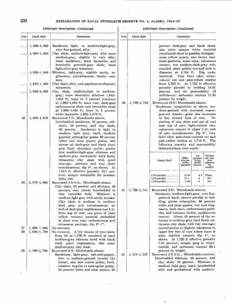
238 EXPLOBATION OF NAVAL PETBOLEUM RESEBVE NO. 4, ALASKA, 1944-53
Lithologic description Continued
Core
____
____
____
35
36
3738
39
Depth (feet)
1, 580-1, 600
1, 600-1, 630
1, 630-1, 640
1, 640-1, 650
1, 650-1, 669
1, 669-1, 676
1, 676-1, 686
1, 686-1, 6961, 696-1, 700
1, 700-1, 706
Description
Sandstone, light- to medium-light-gray,very fine-grained, silty.
Clay shale, medium-light-gray with somemedium-gray, slightly to very silty;trace sandstone; trace bentonite andbentonitic greenish-gray shale; tracelight-olive-gray ironstone.
Siltstone, light-gray, slightly sandy, argillaceous, noncalcareous; biotite common.
Clay shale, silty, and argillaceous siltstone;micaceous.
Clay shale, medium-light to medium-gray; trace bentonitic siltstone 1,645-1,655 ft; trace to 5 percent ironstoneat 1,660-1,669 ft; trace coal; dark-graycarbonaceous shale and bentonitic shaleat 1,660-1,669 ft; trace to 5 percentwhite bentonite 1,665-1,670 ft.
Recovered 7 ft. Microfossils absent.Interbedded sandstone, 40 percent, silt-
stone, 30 percent, and clay shale,30 percent. Sandstone is light tomedium light gray, hard, mediumgrained; subangular grains 80 percentwhite and clear quartz grains; restalmost all dark-gray and black chertplus fairly abundant pyrite; gradesinto medium-light-gray siltstone andmedium-gray moderately hard finelymicaceous clay shale with goodcleavage; siltstone and clay shalenoncalcareous; dip 6°; no shows. At1,673 ft effective porosity 15.7 percent; sample unsuitable for permeability test.
Recovered 4 ft 6 in.: Microfossils absent.Clay shale, 60 percent and siltstone, 40
percent, very closely interbedded inthin varvelike beds. Siltstone ismedium light gray with sandy streaks.Clay shale is medium to mediumdark gray and noncalcareous; aninch of dark-gray argillaceous coal 6 in.from top of core; one piece of clearyellow resinous material embeddedin shale near coal; carbonaceous andmicaceous partings; dip 3°-7°.
No recovery.No recovery. A few chunks of core taken
from bit at 1,700 ft consisted of hardmedium-gray siltstone laced with blackcoaly plant impressions; also somemedium-gray clay shale.
Recovered 6 ft: Microfossils absent.Sandstone, light-gray, salt-and-pepper,
fine- to medium-grained (mostly thelatter), also rare coarse grains; hard,massive; angular to subangular grains,65 percent white and clear quartz, 20
Lithologic description Continued
Core
40
41
42
Depth (feet)
1, 706-1, 722
1, 722-1, 731
1, 731-1, 737
Description
percent dark-gray and black chert,also some opaque white material(weathered chert or possibly feldspar)some yellow quartz, rare brown ironstone particles, some mica; calcareouscement; one medium-dark-gray sub-rounded chert pebble one-half inch indiameter at 1,704 ft. Dip undetermined. Very faint odor, straw-colored cut and pale-yellow residuefrom 1,702 ft. At 1,702 ft effectiveporosity parallel to bedding 16.61percent, and air permeability 13millidarcys; carbonate content 17.55percent by weight.
Recovered 16ft: Microfossils absent.Sandstone, composition as above, me
dium-grained with scattered coarsegrained streaks; grain size decreasesto fine toward base of core. Onparting of ciay shale and one of coalnear top of core; light-colored verycalcareous cement in upper 2 ft; restof core noncalcareous; dip 5°; veryfaint odor, pale-straw-colored cut andpale-yellow residue at 1,710 ft. Thefollowing porosity and permeabilitydeterminations were made:
Air Carbon-Effec- permea- ate con-
Depth (feet) tive po- bility tentrosity (milli- (percent
(percent) darcys) byweight)
1,710 parallel-- ----- 14.65 9.5 Trace.1,715 parallel . ----- 15.4 6 Do.1, 719 parallel ----- 9.82 0 Do.
Recovered 8 ft: Microfossils absent:Sandstone, medium-light-gray, very fine
grained, hard; cleaves parallel to bedding; grains subangular, 85 percentwhite and clear quartz; rest rock fragments, dark chert, carbonaceous particles, and common biotite; argillaceouscement. About 10 percent of the recovery is medium-gray hard finely micaceous clay shale, with fair cleavage;noncalcareous to slightly calcareous inupper few feet of core where there issome sideritic cement; dip 4°; noshows. At 1,725 ft effective porosity7.62 percent; sample plug is impermeable, and carbonate content 28.4percent by weight.
Recovered 3 ft 6 in. : Microfossils common.Interbedded siltstone, 60 percent, and
clay shale, 40 piercent. Siltstone ismedium light gray, hard; interbeddedwith and gradational with medium-

TEST WELLS, GTJB1K AREA'/ ALASKA 239
Lifhologic description Continued
Core
____
____
____
"
____
-__.
____
____
4344
Depth (feet)
1, 737-1, 745
1, 745-1, 750
1, 750-1, 765
1, 765-1, 770
1, 770-1, 780
1, 780-1, 795
1, 795-1, 806
1, 806-1, 8131, 813-1, 820
Description
gray hard finely micaceous clay shalewith fairly good cleavage; noncalcar-eous; dip 5°; no shows. At 1,730 fteffective porosity 4.89 percent, andsample plug impermeable.
Clay shale, 60 percent, medium-light-gray;30 percent light-gray siltstone; and 10percent light-gray medium-grained sandstone; trace very light-gray bentoniticclay shale; coal and ironstone.
Sandstone, light-gray, very fine-grained,noncalcareous, hard; subrounded to sub-angular grains, 85 percent white andclear quartz, also black carbonaceousfragments, dark chert, and mica; 5 percent medium-gray clay shale.
Bentonite, white; also medium-dark-grayclay shale; trace grayish-black carbonaceous shale and coal; trace slightly calcareous very fine- to fine-grained sandstone.
Clay shale, medium-light-gray; trace sandstone, bentonite, and coal.
Sandstone, light-gray, medium-grained;subangular to (rarely) subroundedgrains, 85 percent white and clear quartz;rest mostly dark-gray and black chert,some coal particles; trace clay shale andcoal.
Clay shale, medium-light-gray; trace carbonaceous shale, bentonite, and ironstone; 15 percent sandstone at 1,790-1,795 ft.
Sandstone, light-gray, salt-and-pepper,very fine- to very coarse-grained, non-calcareous, soft; 65 percent white andclear quartz, 30 percent dark-gray andblack chert, some coal particles and mica,rare rounded black chert granules; traceto 10 percent medium-light-gray clayshale; 10 percent shiny black coal at1,800-1,805 ft; trace very light-graybentonitic clay shale at 1,805-1,810 ft.
No recovery.Recovered 7 ft: Microfossils absent.
1 ft 6 in., interbedded siltstone, 90 percent, and clay shale; medium-light-gray and medium-gray, noncalcareous,hard, sandy, with fair cleavage; dip 9°.
5 ft 6 in., sandstone, light-gray, medium-to coarse-grained, noncalcareous, medium-hard but slightly friable; good,nearly poker-chip cleavage; grains sub-angular; salt-and-pepper sandstone; 55percent white and clear quartz grains,40 percent rock fragments and dark-gray, brownish, and black chert;other minerals rare; argillaceous cement; numerous coaly partings; quitecoaly in the lowest 6 in. of recovery;
lAtnologic description Continued
Core
45
46
47
48
49
Depth (feet)
1, 820-1, 826
1, 826-1, 836
1, 836-1, 841
1, 841-1, 848
1, 848-1, 868
Description
rare clay shale laminae; drop test indicates moderate porosity; dip 9°; noshows.
Recovered 6 ft: Microfossils absent.Sandstone, light-gray, clean, coarse
grained, soft to nearly unconsolidated;friable although upper 2 ft of recoverywas hard; cleaves approximately parallel to bedding; subangular, salt-and-pepper sandstone, 50 percent whiteand clear quartz grains, 45 percentdark-gray and brown chert, rock fragments, and coaly particles; mica andother minerals rare; loosely cementedwith argillaceous material and insome places with calcite. Rare carbonaceous partings in upper foot ofrecovery; very calcareous in upper 2ft and noncalcareous below; dip 10°;no shows.
Recovered 6 ft 6 in.: Microfossils absent.Sandstone, color and composition as
above, soft, coarse, rarely very coarse,noncalcareous; dip undetermined.
Recovered 4 ft. : Microfossils absent.Sandstone, color and composition as
above, nearly unconsolidated, coarse-to very coarse-grained, noncalcareous;55 percent dark minerals and rockfragments, 45 percent light-coloredquartz; dip undetermined; no shows.
Recovered 7 ft: Microfossils absent.Sandstone, light-gray, coarse- to very
coarse-grained, noncalcareous, salt-and-pepper, soft, friable, clean, poker-chip cleavage; subangular to sub-rounded grains, 55 percent dark-gray,brown, and black chert, dark-coloredrock fragments and coaly particles, 45percent white and clear quartz, veryrare rounded black chert granules andpebbles; also brown flat pebbles or nodules of clay ironstone as much as 2 in.in diameter particularly at 1,847 ft;one 2-in. medium-gray clay shale pebble at 1,845ft; argillaceous cement; dip9°; faint odor, straw-colored cut, yellow residue from 1,843 ft; faint odor,pale-straw-colored cut, and yellowresidue from 1,846 ft. At 1,843 ft effective porosity 25.2 percent, and airpermeability 3,780 millidarcys parallelto bedding.
Recovered 20 ft: Microfossils absent.Sandstone as above, but slightly more
consolidated; cleavage not developedquite as well; brown ironstone nodulesas much as 1-in. thick at 1,848, 1,849,1,850, 1,858, 1,861, 1,862, and 1,865ft. Black carbonaceous plant frag-

240 EXPLORATION OF NAVAL PETROLEUM RESERVE NO. 4, ALASKA, 1944-53
Litliologie description Continued
Core Depth (feet)
50 1, 868-1, 880
51 1, 880-1, 885
Description
ments and black coaly laminae at 1,855, 1,861, and 1,864 ft; clear yellow resinous material in the coal; very calcareous in upper foot of core and rarely in other spots, nonealeareous elsewhere; dip 8°; faint odor, pale- straw-colored cut, yellow residue from 1,852 ft; faint odor, pale-yellow cut, brownish-yellow residue from 1,856 ft; faint odor, yellow cut and yellow- brown residue from 1,861 and 1,865 ft. Following porosity and permeability determinations were made.
Depth (feet)
1,852 parallel---- 1,861 parallel .- 1,865 parallel ...
Effec tive po rosity
(percent)
25.418.3519.5
Airpermea bility (milli-
darcys)
Not suitable 61 95
Carbon ate con
tent
Trace. Do. Do.
Recovered 12 ft: Mierofossils absent.5 ft 6 in,, sandstone, light-gray, medium-
to (rare) coarse-grained, medium-soft; cleaves parallel to bedding; subangular grains, 60 percent white and clear quartz; rest mostly brown and gray chert; other minerals rare; argillaceous cement except for 6 in. with light- colored very calcareous cement at 1,873 ft; scattered dark carbonaceous partings; dip 9°; faint odor, yellow cut and yellowish-brown residue at 1,872 ft. At 1,871 ft effective porosity 19.64 percent, and air permeability 270 millidareys (plug cracked); essen tially nonealeareous. At 1,873 ft porosity 5.45 percent, and sample plug impermeable; carbonate content 24.8 percent by weight. Abrupt change to unit below.
5 ft, siltstone, medium-light-gray, me dium-hard; excellent cleavage in part; much finely disseminated carbona ceous material and scattered partings with black broken plant fragments; rare irregular sandy lenses; dip 4°-7°; grades into unit below.
1 ft 6 in., clay shale, medium-light-gray, nonealeareous, rather hard and brittle, thin-bedded; uniform in color and tex ture; fair cleavage; }£-in. layer of yellowish-gray clay ironstone and Yz-in. layer light-gray soft bentonitic shale near base.
Recovered 5 ft: Mierofossils absent.Clay shale, medium-light- to medium-
gray, nonealeareous, medium-soft to
Litholoffic description Continued
Core
52
Depth (feet)
1, 885-1, 900
1, 900-1, 910
1, 910-1, 915 1, 915-1, 935
Description
medium-hard; poor to fair hackly cleavage; possibly slightly bentonitie; medium-light-gray siltstone laminae as much as 2 in. thick also present; dip 7°.
Clay shale, medium-light- to medium-gray; trace siltstone and ironstone; also trace very calcareous medium- to coarse grained sandstone as below.
Sandstone, light-gray, salt-and-pepper, fine- to coarse-grained granule; grains suban gular to subrounded; granules rounded; quartz and chert grains; very calcareous cement in part, loose sand grains in part; 10 percent medium-light-gray clay shale and 5 percent clay ironstone.
Clay shale, medium-light- to dark-gray. Recovered 20 ft: Mierofossils absent.
2 ft, elaystone, medium-dark-gray, non ealeareous, hard, dense; hackly or no cleavage; subeonchoidal fracture; al most vertical sliekensides at 1,916 ft; excellent small black leaf impressions throughout the core. These leaves identified by Roland W. Brown, U. S. Geological Survey, as Trapa? micro- phylla Lesquereux, which ranges in age from Late Cretaceous to Paleoeene; grades down into unit below.
8 ft, interbedded siltstone, 70 percent, and very fine-grained sandstone; light- to medium-light-gray, hard, argilla ceous; some small scale crossbedding; impression of large leaf at 1,923 ft, shiny black coal fragments 2 in. long embedded in the sandstone at 1,924 ft; sandstone very slightly calcareous; dips variable, average about 7°; grades into unit below.
10 ft, sandstone, light-gray, medium- to (very rare) coarse-grained, medium- hard, massive; irregular fracture; sub- angular to subrounded grains, 50 per cent white and clear quartz; rest is dark-gray, brown, and black chert, rock fragments, and scattered coaly particles; very rare ironstone nodules; dip undetermined; no odor, no cut, very pale-yellow residue from 1,932 ft.
Depth (feet)
1,924 paralleL 1,928 parallel. 1,932 parallel-
Effec tive po rosity
(percent)
12.2418.7 5.5
Airpermea bility (milli
dareys)
222
Carbon ate con
tent (percent
by weight)
Trace.13.5.30.5.

TEST WELLS, GUBIK ABEA, ALASKA 241
LAthologic description Continued
Core Depth (feet)
53 1, 935-1, 955
54 1, 955-1, 960
55 1, 960-1, 980
Description
Recovered 20 ft: Microfossils absent. Sandstone color and composition as
above, grain size variable, very fine- to fine-grained in the upper 6 ft; also numerous partings with broken black leaf impressions. Rest of core medium grained; no odor, no cut, greasy film in evaporating dish, from 1,948 ft.
Depth (feet)
1,939 paralleL 1,944 parallel. 1,948 paralleL
Effec- tive po rosity
(percent)
4.4414.815.0
Airpermea bility (milll-
darcys)
012.514
Carbon ate con
tent (percent
by weight)
53.8. Trace.
Do.
Recovered 5 ft: Microfossils absent.4 ft, sandstone, light-gray, fine- to (rare)
coarse-grained, hard; irregular frac ture; subangular grains; constituents as above but with 75 percent white and clear quartz; very rare silty lami nae; noncalcareous to very calcareous in thin light-colored streaks; dips as much as 15° probably indicate cross- bedding; no shows. At 1,957 ft effec tive porosity 16.8 percent, and air permeability 12.5 millidarcys parallel to bedding.
1 ft, coal, shiny to dull, black, blocky fracture, a few inches of carbonaceous sandstone at base.
Recovered 20 ft: Microfossils absent.Sandstone, light-gray, hard, fine- to
medium-grained; massive in upper half of core, subangular to subrounded grains, 75 percent white and clear quartz, 20 percent dark-gray and black chert, dark-colored rock frag ments, and coal particles; some dark carbonaceous coaly partings particu larly in lower half of core, some clear resinous material with the coal; two small rounded black-chert pebbles (three-fourths inch in diameter) at 1,972 ft. Six inches of paper-thin lam inae of clay shale topping at 1,973 ft, medium-light-greenish-gray, contains abundant black carbonaceous par ticles, also much biotite and large (one-sixteenth inch) plates of white mica; matrix resembles bentonite but does not swell when moistened; non- calcareous to very calcareous cement; dip 5°-7°; no shows. Porosity and
Lithologic description Continued
Core
56
57
58
Depth (feet)
1, 980-1, 984
1, 984-1, 995
1. 995-2, 000
2. 000-2, 030
2, 030-2, 069
2, 069-2, 079
2, 079-2, 089
Description
permeability determinations were made as follows:
Depth (feet)
1,964 parallel -------
1 Q77 narallpl
. Effective por
osity(percent)
16.74.8
18.6
Airpermeability(milli-
darcys)
500
22.5
Carbonate con
tent(percent
by weight)
8.2430.3517.71
Recovered 4 ft: Microfossils absent. Sandstone, light-gray, fine-grained, non-
calcareous, hard; breaks parallel to bedding; some very fine-grained and silty layers; 85 percent white and clear quartz grains; rest is mostly dark chert, carbonaceous particles, and some mica; rare thin laminae of light- gray clay shale; dip 3°; no shows.
Sandstone, light-gray, very fine-grained, soft, noncalcareous; 95 percent white and clear quartz grains, rare dark chert and biotite.
Clay shale, 70 percent, medium-light-gray,and sandstone as above.
Sandstone, light-gray, salt-and-pepper; fine- to medium-grained, 75 percent white and clear quartz grains; white, very calcareous matrix at 2,020-2,030 ft. The top of the Seabee formation is placed at 2,010 ft.
Clay shale, 50-80 percent, medium-light- gray and light-gray, fine- to medium- grained sandstone; trace brownish-gray cJay ironstone at 2,050-2,060 ft.
Recovered 10 ft: Microfossils absent. 4 ft, claystone, medium-gray, hard,
dense; irregular fracture; finely dis seminated mica gives a sheen to the fracture surfaces.
6 ft, interbedded clay shale, 85 percent, and siltstone, 15 percent. Clay shale is medium gray; alternates with very thin beds of medium-light-gray hard siltstone, with good cleavage, and rare carbonaceous flecks: yellowish- gray ironstone concretions fairly com mon; noncalcaredus; dip 7°.
Recovered 10 ft: Microfossils rare.Interbedded clay shale as above, 65 per
cent, and siltstone, as above, 35 per cent, contacts between the two mostly quite sharp; small amount of grada tion; rare carbonaceous partings; iron stone lenses and laminae present; noncalcareous; dip 5°-7°.

242 EXPLORATION OF NAVAL PETROLEUM RESERVE NO. 4, ALASKA, 1944-53
Lithologic description Continued
Core
59
60
61
62
____
____
Depth (feet)
2, 089-2, 109
2, 109-2, 129
2, 129-2, 145
2, 145-2, 146
2, 146-2, 155
2, 155-2, 170
Description
Recovered 20 ft: Microfossils common.10 ft 6 in., interbedded siltstone, as
above, 75 percent and clay shale asabove; 6 inches of light-gray medium-grained sandstone at 2,090 ft; yellowish-gray ironstone nodule at 2,093ft; a few very small white pelecypodsand gastropods at 2,095 ft; some pyritestringers; noncalcareous; dip 5°-7°.
9 ft 6 in., sandstone, light-gray, finegrained, hard, massive; subangulargrains, 80 percent white and clearquartz, some with yellowish tinge;rest is dark chert, rock fragments, coalparticles and mica; some calcareouscement; no shows. At 2,100 ft effective porosity 14.32 percent, air permeability 3.5 millidarcys and carbonate content 12.85 percent by weight.At 2,107 ft porosity 15.4 percent, permeability 6.1 millidarcys, and carbonate content 16.51 percent.
Recovered 17 ft: Microfossils absent.Sandstone, light- to medium-gray, very
fine- to fine-grained, silty, hard tovery hard; irregular fracture; composition as in core above; upper6 ft of core extremely calcareous,nearly a silty limestone; at 2,113 ft a116-in.-thick white-calcite vein extends at an angle of 70° through thecore; one small poorly preserved pele-cypod at 2,127 ft; dip 5°; no shows.At 2,110 ft effective porosity 0.75 percent, sample impermeable, and carbonate content 49.6 percent by weight.At 2,125 ft porosity 15.2 percent, permeability 4.5 millidarcys, and carbonate content 21.05 percent.
Recovered 16 ft: Microfossils rare.Siltstone and very fine-grained sand
stone, light- to medium-light gray,medium-hard; excellent cleavage; numerous partings containing black carbonaceous plant particles; 5-10 percent thin medium-gray laminae ofclay shale; noncalcareous; dip 6°; noshows. At 2,132 ft effective porosity11.39 percent, and at 2,140 ft 7.3 percent. Both samples impermeable.
Recovered 1 ft: Microfossils rare.Siltstone with clay shale streaks as
above; dip 5°.Clay shale, 80 percent, medium-light-gray;
and light-gray fine- to medium-grainedsandstone.
Siltstone and very fine-grained sandstone,light- to medium-light-gray, noncalcareous; trace to 10 percent medium-light-gray clay shale.
Lithologie description Continued
Core
63
64
65
66
67
.__.
____
- ». _ _
-__ _
Depth (feet)
2, 170-2, 180
2, 180-2, 190
2, 190-2, 200
2, 200-2, 210
2, 210-2, 218
2, 218-2, 370
2, 370-2, 400
2, 400-2, 470
2, 470-2, 510
2, 510-2, 520
2, 520-2, 680
2, 680-2, 690
Description
Recovered 7 ft: Microfossils abundant.Interbedded siltstone, 60 percent, and
clay shale, 40 percent, medium-light-and medium-gray, noncalcareous, medium-hard; excellent cleavage; micaceous-carbonaceous partings; dip 6°.
Recovered 9 ft: Microfossils very abundant.
Interbedded siltstone as above, 50 percent, and clay shale, as above, 50 percent; dip 5°.
Recovered 10 ft: Microfossils abundant.Clay shale, medium-dark-gray, medium-
hard, good cleavage; about 25 percentmedium-light-gray thin siltstone laminae; carbonaceous and micaceous partings; fragment of unidentified dicotyledonous leaf; noncalcareous; dip 6°.
Recovered 8 ft: Microfossils abundant.4 ft, clay shale, medium-dark-gray, non-
calcareous, hard; 5 percent silty laminae; one tiny white mollusk fragment attop of core; poor to fair cleavage.
1 ft 3 in., limestone, medium-light- tomedium-gray, hard, argillaceous; irregular fracture.
2 ft 9 in., clay shale as in upper part ofcore; carbonaceous and micaceouspartings; dip 6°.
Recovered 2 ft: Microfossils abundant.Clay shale as immediately above.
Clay shale, medium-light- to medium-dark-gray, primarily medium-gray; asmuch as 10 percent medium-light-graycalcite at 2,315-2,325 ft.
Clay shale, medium-light- to medium-dafk-gray, micaceous; trace siltstone.
Clay shale, medium-light- to medium-gray;trace siltstone at 2,420-2,460 ft.
Clay shale, medium-light- to medium-gray;trace to 5 percent siltstone, one-third ismedium light to light gray at 2,490-2,510ft; 30 percent bentonitic light-grayshale 2,470-2,480 ft; trace of medium-light-gray limestone and aragonite at2,470-2,480 ft; trace of bentonitic clayshale; and 5 percent very calcareous silt-stone at 2,480-2,490 ft.
Siltstone, 90 percent, light-gray, slightlycalcareous; and medium-gray clay shale.
Clay shale, medium-light- to medium-gray;10 percent shiny to dull black coal at2,520-2,530 ft; 10 percent medium-light-gray siltstone; some medium-dark-grayshale; clump of Inoceramus prisms at2,540-2,550 ft; pieces of Inoceramus shelland fish fragments at 2,670-2,680 ft.
Siltstone, medium-light-gray, argillaceous,noncalcareous, and medium-gray clayshale; clump of Inoceramus prisms.

TEST WELLS, GUBJK AREA, ALASKA Z*?
LWwlogie description -Continued
Core
____
-___
____
__._
_.__
--__
____
____
-,.-
____
----
* _ - _
Depth (feet)
2, 690-2, 700
2, 700-2, 760
2, 760-2, 770
2, 770-2, 780
2, 780-2, 790
2, 790-2, 800
2, 800-2, 810
2, 810-2, 840
2, 840-2, 870
2, 870-2, 900
2, 900-2, 930
2, 930-2, 940
2, 940-2, 950
2, 950-3, 040
Description
Clay shale, medium- to medium-dark-gray;one piece of Inoceramus shell; trace silt-stone and trace light-gray bentonite containing biotite plates.
Clay shale, medium-light- to medium-gray,silty; trace coal at 2,740-2,750 ft;chunks of Inoceramus prisms at 2,700-2,710 and 2,740-2,750 ft; some medium-dark-gray clay shale and fish fragmentsat 2,750-2,760 ft.
Clay shale, medium-light-gray; trace light-gray bentonitic clay shale; trace coal,Inoceramus chunks.
Clay shale, medium-gray; trace brownish-gray limestone.
Clay shale, medium-gray; trace whitebentonite and shiny black coal; Inoceramus chunk.
Clay shale, medium-gray; some medium-light-gray siltstone; slightly calcareous;trace medium-dark-gray limestone; smallcalcite vein; trace white bentonite;Inoceramus chunks.
Siltstone, 70 percent, medium-light- tomedium-gray, very calcareous; medium-dark-gray limestone and clay shale asmuch as 30 percent; trace very light-gray bentonitic clay shale and whitebentonite; trace shiny black coal.
Clay shale, medium-gray, silty; trace whitearagonite and bentonitic clay; Inoceramus prisms at 2,810-2,820 ft.
Clay shale, medium-gray, and as much as30 percent medium-light-gray siltstone;trace sandstone at 2,860-2,870 ft.
Clay shale, medium- to medium-dark-gray;trace coal; trace very light- and greenish-gray clay shale; trace limestone andwhite calcite crystals at 2,890-2,900 ft;Inoceramus chunks.
Clay shale, medium- to medium-dark-gray; trace coal at 2,900-2,920 ft; tracevery fine-grained sandstone at 2,910-2,920 ft., contains biotite.
Sandstone, light- to medium-light-gray, soft, very fine- to (rarely) medium- grained; 85 percent white and clear quartz grains; rest dark-colored chert, rock fragments, and some biotite; harder chips of sandstone very slightly calcareous; trace medium-gray clay
Clay shale, medium-gray; 30 percent sand stone as above.
Clay shale, light- to medium-dark-gray,mostly medium-gray; trace siltstone at2,980-2,985 ft and 3,010-3,020 ft; Inoceramus prisms at 2,970-2,975 ft and2,985-2,990 ft.
LithfAogic description Continued
Core
68
69
70
____
_ _ _ _
Depth (feet)
3, 040-3, 100
3, 100-3, 110
3, 110-3, 120
3, 120-3, 126
3, 126-3, 155
3, 155-3, 160
Description
Clay shale, medium-dark-gray; trace to 15percent very light-gray to white bentonite or bentonitic shale; bentonitecontains brown biotite plates. Tracewhite aragonite at 3,090-3,095 ft;Inoceramus prisms, fish fragments, andRadiolaria also present. This may becompared to the black fissile shale ofUmiat area.
Recovered 10 ft: Microfossils abundant.4 ft 6 in., clay shale, medium-dark-gray,
moderately hard; fair cleavage; biotitecommon; 2 in. light-gray bentoniticshale at 3,102 ft and 1 in. at 3,104 ft.Shale includes much white aragoniteextending 5 in. along the beddingplanes and terminating upward at3,103% ft; also a few thin verticalveins of aragonite. Clay shale gradesinto unit below.
5 ft 6 in., sandstone, light-gray, veryfine-grained (grading to siltstone),slightly to moderately calcareous,massive, hard; irregular fracture;grains subangular, 75 percent white andclear quartz; rest is rock fragments,dark chert, biotite, and carbonaceousparticles; dip undetermined; no showsin laboratory, but well geologist reported core bled slight amount of gas.At 3,106 ft effective porosity 11.31 percent, sample plug impermeable, andcarbonate content 8.63 percent byweight.
Recovered 10 ft: Microfossils absent.Sandstone, very silty, noncalcareous to
slightly calcareous; 90 percent whiteand clear quartz; dips as high as 15°probably indicate crossbedding; regular dip about 4° (?); no shows. At3,112 ft effective porosity 10.6 percent, sample impermeable, and carbonate content 9.79 percent by weight.
Recovered 6 ft: Microfossils absent. 5 ft 6 in., very fine-grained sandstone, as
above, and siltstone; a few inches of medium-light-gray clay shale at 3,120 ft. Clay shale contains very light- gray silty slightly bentonitic partings; dip undetermined, probably low: juon- calcareous; no shows.
6 in., limestone, medium-gray, silty, argillaceous, medium-hard.
Clay shale, medium-light- to medium-dark-gray, silty; trace bentonite.
Siltstone 60 percent, medium-light-gray,argillaceous, and medium-gray clayshale.

244 EXPLORATION OF NAVAL PETROLEUM RESERVE NO. 4, ALASKA, 1944-53
Lithologic description Continued
Core
____
___ _
___ _
____
____
____
____
____
_-,_
____
__-_
71
Depth (feet)
3, 160-3, 175
3, 175-3, 185
3, 185-3, 200
3, 200-3, 220
3, 220-3, 225
3, 225-3, 240
3, 240-3, 245
3, 245-3, 250
3, 250-3, 260
3, 260-3, 285
3, 285-3, 300
3, 300-3, 320
3, 320-3, 324
3, 324-3, 333
Description
Clay shale, medium- to medium-dark-gray, silty; trace to 15 percent bluish-gray bentonite; trace aragonite; chunkof Inoceramus prisms.
Clay shale, medium- to medium-dark-gray; 10 percent white and very light-gray bentonite with biotite plates; traceshiny black coal, pyrite, and fish fragments; Inoceramus prisms.
Clay shale, medium-light- to medium-gray; trace medium-light-gray siltstone.
Sandstone, light-gray, fine-grained, non-calcareous; grains subangular and sub-rounded, 85 percent white and clearquartz; rest mostly dark chert, rock fragments, and biotite; also 40 percentmedium-light-gray clay shale.
Siltstone, 80 percent, medium-light-gray;and medium-gray noncalcareous clayshale.
Clay shale, medium-gray, silty, and asmuch as 30 percent siltstone.
Siltstone, light- to medium-light-gray, veryargillaceous; trace medium-gray clayshale.
Clay shale, medium-light- to medium-gray,and 30 percent of medium-light-graysiltstone.
Sandstone, light-gray, very fine-grained,and 5 percent medium-dark-gray silt-stone.
Clay shale, medium-light- to medium-dark-gray; trace to 5 percent white bentoniteand bentonitic shale; as much as 50 percent siltstone; trace very fine-grainedsandstone; trace white aragonite at3,275-3,280 ft; 20 percent light-greenish-gray bentonitic shale at 3,280-3,285 ft;chunk of Inoceramus prisms and fishfragments at 3,265-3,270 ft.
Sandstone and siltstone. Sandstone islight gray, very fine grained, noncalcareous; grains subangular to sub-rounded, 95 percent white and clearquartz; trace to 5 percent medium-gray-clay shale; chunk of Inoceramus prismsat 3,290-3,295 ft.
Siltstone, medium-light-gray, and 10-50percent medium-gray clay shale; tracecoal and bentonite at 3,310-3,315 ft,trace of very fine-grained sandstone at3,315-3,320 ft. Inoceramus chunks andprisms at 3,310-3,320 ft.
Sandstone, light-gray, noncalcareous; 90percent white and clear quartz grains,some biotite; also siltstone and clay shale.
Recovered 3 ft. Microfossils absent.Clay shale, medium-light- to medium-
gray, noncalcareous, medium-hard;fair cleavage; Inoceramus shell frag-
Litholoffic description Continued
Core
72
73
74
75
76
77
Depth (feet)
3, 333-3, 343
3, 343-3, 353
3, 353-3, 363
3, 363-3, 368
3, 36S-3, 380
3, 380-3, 400
Description
ments firmly embedded in the shale;some thin laminae of siltstone; pyritenodules; dips as much as 10°.
Recovered 10 ft: Microfossils absent.Siltstone, medium-light-gray, sandy,
medium-hard; nearly poker-chip cleavage in upper 7 ft of recovery; lower 3ft somewhat harder siltstone with nocleavage; slightly micaceous; noncalcareous except lower siltstone whichis slightly calcareous. Inoceramusprisms in microfossil cut.
Recovered 8 ft. Microfossils absent.3 ft, siltstone, medium-light-gray, non-
calcareous, medium-hard; near poker-chip cleavage.
5 ft, siltstone, medium-light-gray, non-calcareous to moderately calcareous,hard, massive, and some very finegrained micaceous sandstone, composed almost entirely of white andclear quartz grains; dip approximately5°; no shows.
Recovered 10 ft. Microfossils absent.Siltstone, medium-light-gray, argilla
ceous; poor to fair cleavage; micaceous(biotite) partings. Bladelike inclusions of silty medium-dark-gray clayare 1 in. wide, Ys-% in. thick, andgenerally several inches long with variable orientation; possible mollusk borings; noncalcareous to moderately calcareous; dip 5°.
Recovered 4 ft. Microfossils rare.Claystone, medium-gray, silty, mica
ceous, noncalcareous, moderately-hard; irregular fracture approximatelyparallel to bedding; dip undetermined.Inoceramus prisms in microfossil cut.
Recovered 12 ft: Microfossils common.Siltstone, medium-light-gray, argilla
ceous; and medium-gray silty clayshale, interbedded and grading fromone to the other; upper half of coregenerally more argillaceous and lowerpart more silty and micaceous (notbiotite) ; poorly preserved small pele-cypod impression at 3,372 ft; lowerhalf of core has "borings" as describedin core 74 above some as much as 2in. wide; noncalcareous; dips as muchas 12°; average about 5°. Inoceramusprisms in microfossil cut.
Recovered 20 ft: Microfossils absent.15 ft, siltstone, medium-light-gray and
some medium-gray clay shale laminae;noncaleareous to moderately calcareous; essentially as in cores above;"borings" present; some irregular bedding suggests local disturbance prob-

TEST WELLS, GUBIK ABBA, ALASKA 245
Litholoffic description Continued
Core
_--_
----
____
_ _ _ _
----
78
79
Depth (feet)
3, 400-3, 425
3, 425-3, 435
3, 435-3, 445
3, 445-3, 460
3, 460-3, 475
3, 475-3, 480
3, 480-3, 490
3, 490-3, 500
Description
ably close to time of deposition; brokenInoceramus shells distributed irregu*larly in swirly beds at 3,379ft; dips asmuch as 15°; general dip probably3°-5°; sandier toward base and gradesinto sandstone below.
5 ft, sandstone, light-gray, veiy finegrained, silty, noncalcareous to veryslightly calcareous, hard, massive; sub-angular to subrounded grains, 95 percent white and clear quartz; rest carbonaceous particles and mica; dip undetermined; no shows. At 3,395 fteffective porosity 9.45 percent, andsample plug impermeable.
Sandstone, light gray, very fine- to finegrained, slightly to very calcareous; contains biotite plates and trace of siltstone ;20 percent of light-olive-gray clay iron stone at 3,410-3,415 ft; trace greenish- gray bentonite with biotite plates at3,415-3,425 ft.
Siltstone and very fine-grained sandstonecontaining biotite, very slightly calcar eous; trace medium-gray clay shale.
Clay shale, 60 percent, medium-gray; andmedium-light-gray siltstone, with biotite; 5 percent white bentonite, andtrace of white aragonite at 3,440 ft.
Siltstone,. medium-light- to medium-gray, very argillaceous, noncalcareous; tracemedium-gray clay shale and fish fragments at 3,445-3,460 ft.
Sandstone, light-gray, fine-grained, non-calc&reous; grains subangular to sub-rounded, 90 percent white and clearquartz, also dark chert and carbonaceous particles, some biotite and white mica.
Siltstone, medium-light-gray, and 15 per cent white bentonite.
Recovered 10 ft: Microfossils absent. Interbedded clay shale, 75 percent, and
siltstone. Clay shale is medium darkgray to dark gray, medium soft, micaceous (not biotite) ; good cleavage; numerous laminae and lenses as muchas 3 in. thick of medium-light-gray siltstone; very rarely slightly sandy; noncalcareous; dip 3°-7°.
Recovered 9 ft: Microfossils absent.Sandstone, medium-light-gray, very fine
grained, silty, noncalcareous, hard;tends to cleave normal to sides of core;subangular grains, 85 percent whiteand clear quartz; rest dark chert, rockfragments, and rare carbonaceous andchalky white particles; rare medium-gray clay shale partings; small amountof irregular bedding; dip 3°; no shows.
Lithologic description Continued
Core
80
81
82
83
84
Depth (feet)
3, 500-3, 510
3, 510-3, 518
3, 518-3, 528
3, 528-3, 537
3, 537-3, 540
Description
Recovered 3 ft: Microfossils absent.Ihterbedded siltstone, 80 percent, and
clay shale, 20 percent. Siltstone ismedium light gray, medium hard, andslightly micaceous; has good cleavage;contains many laminae and partingsof medium-gray clay shale; noncalcareous; dips range from 3°-10°.Inoceramus prisms in microfossil cut.
Recovered 4 ft: Microfossils absent.Interbedded clay shale, as above, 75
percent, and siltstone, as above, 25percent; gradation from one to theother; undulatory surfaces on siltstonesuggest ripple marks; slightly micaceous; noncalcareous; dip 7°. Inoceramus prisms in microfossil cut.
Recovered 10 ft: Microfossils absent.Sandstone, light-gray, medium-hard, fine
grained; excellent, nearly poker chip cleavage; subangular salt-and-peppergrains; 65 percent white and clearquartz, nearly 35 percent black chert,rock fragments, and coaly particles, some chalky white particles; otherminerals rare; rare medium-gray clayshale laminae and very rare clay chipsin the sandstone; slightly to moderately calcareous; dip 8°; no shows;well geologist reported slight odor. Effective porosity at 3,526 ft 12.62percent, at 3,527 ft 13.11 percent. Inboth samples air permeability <1 millidarcy. Carbonate content at3,526 ft 18.64 percent by weight;other sample not tested.
Recovered 9 ft: Microfossils absent.Sandstone, as above, very rare medium
grains; poker chip cleavage; 5 in. ofmedium-dark-gray claystone at very bottom of core; slightly to moderately calcareous; dip 4° (?) ; no shows; wellgeologist reported slight odor. At 3,529 ft effective porosity 13.46 per cent, air permeability 2.3 millidarcys;carbonate content not tested. At 3,530 ft porosity 13.28 percent, perme ability *O millidarcy, and carbonatecontent 16.62 percent by weight.
Recovered 2 ft 6 in.: Microfossils absent.Interbedded clay shale 70 percent, me
dium-gray; and light-gray, hard, slightly micaceous sandstone with faircleavage; rare dark carbonaceous partings in the sandstone; irregular bedding at top; sandstone has very calcareous cement, and shale is moderately calcareous; dip 9°; no shows.

246 EXPLORATION OF NAVAL PETROLEUM RESERVE NO. 4, ALASKA, 1944-53
Lithologic description Continued
Core
____
85
86
Depth (feet)
3, 540-3, 575
3, 575-3, 620
3, 620-3, 640
3, 640-3, 660
-
Description
Clay shale, medium-gEay, rarely medium-dark-gray, moderately calcareous; tracesiltstone and sandstone; 10 percentlight-gray bentonitic shale at 3,550-3,555 ft; chunk of Inoceramus prisms3,565-3,570 ft.
Clay shale, medium- to medium-dark-gray.Top of Chandler and Ninuluk formationsundifferentiated placed at 3,585 ft.
Recovered 19 ft 6 in.: Microfossils abundant.
11 ft, clay shale, medium-dark- to dark-gray, micaceous; medium-hard; goodcleavage; some medium-light-gray siltypartings; light-olive-gray clay ironstone nodule at 3,625 ft; noncalcare-ous; dip 4°-6°.
8 ft 6 in., sandstone, medium-light- tomedium-gray, silty and fine-grained,hard; cleaves parallel to bedding;subangular to subrounded grains,80 percent white and clear quartz;rest dark-colored rock fragments andchert, also pyrite, garnet, and otherrare minerals; some mica and soft.white particles; argillaceous cement; rare carbonaceous and coaly partings, also rare finely micaceous medium-gray clay shale laminae as much as2 in. thick, very thin iight-olive-gray ironstone laminae at 3,636 ft; non-calcareous; dip 4°-7°; fleeting odor, no cut, slight greasy stain in evaporat ing dish at 3,632 ft. At 3,632 ft effective porosity 9.45 percent, and sample impermeable.
Recovered 18 ft: Microfossils absent.10 ft, sandstone, light-gray, very fine- to
fine-grained, hard, massive; composi tion as in core above; 2 feet of medium-grained, salt-and-pepper sandstone at 3,644 ft is slightly softer, with a slightly higher proportion of dark grains than the rest of core ; rare smallmedium-gray clay chips embedded insandstone at 3,651 ft with flat axesparallel to bedding. Numerous brownish-coated pelecypod casts found at3,643 ft. These casts similar in typeand preservation to those at approximately 3,360 ft in Gubik test well 1;non calcareous to slightly calcareous;dip 3°; very fleeting odor, very slightcut and greasy stain in evaporatingdish at 3,645 ft. At 3,645 ft effectiveporosity 10.36 percent, and sampleimpermeable to air.
8 ft, interbedded, hard, very fine-grainedsandstone as above, 50 percent, andmedium-dark-gray, finely micaceous
Lithologic description Continued
Core
87
88
89
90
Depth (feet)
3, 660-3, 669
3, 669-3, 672
3, 672-3, 682
3, 682-3, 684
3, 684-3, 692
Description
hard clay shale; sandstone has somecrossbedding; some laminae and lensesof silt in clay shale; noncalcareous tomoderately calcareous; dip 4°; cross-bedding dips 2°-16°; fleeting odor,pale straw colored cut and very paleyellow residue from 3,651 ft. At 3,651 fteffective porosity 7.19 percent, sampleimpermeable, and carbonate content17.06 percent by weight.
Recovered 7 ft: Microfossils absent.Claystone and clay shale, medium-
gray, medium-soft to medium-hard;cleavage poor where present subcon-choidal fracture; some medium-light-gray siltstone laminae and lenses asmuch as 6 in. thick; first 6 in. of clayshale is soft and laced with whiteveins of aragonite; siltstone is moderately to very calcareous; part of clay-stone is slightly calcareous; dip 2°-20°, average probably nearer 2°.
Siltstone and sandstone, light- to medium-light-gray.
Recovered 9 ft: Microfossils absent. Siltstone and sandstone with a little clay
shale, grading into clay shale with alittle siltstone in lower 5 ft of core.Siltstone and sandstone are light to medium light gray, medium hard;have fair to good cleavages. Sand stone is very fine grained and silty; composed mostly of white and clear quartz, but also contains quite a few coal particles and abundant mica. Clay shale is medium gray, finely micaceous; siltstone is in thin laminae or lenticles in the clay shale; noncal careous to slightly calcareous; dip 2°;good gasolinelike odor, pale-straw- colored cut and yellow residue from 3,674 ft. At 3,674 ft effective porosity 11.5 percent, and sample impermeable.
Recovered 2 ft: Microfossils absent.Interbedded clay shale, as above, 60
percent, and siltstone, as above; silt-stone is slightly calcareous; dip 3°-6°;no shows.
Recovered 8 ft: Microfossils absent.Clay shale, medium- to medium-dark-
gray, moderately hard, finely micaceous; good cleavage; some carbonaceous and micaceous partings; asmuch as 30 percent medium-light-graysiltstone in laminae and lenses; somesmall-scale crossbedding indicated inthe siltstone; siltstone is moderatelycalcareous; clay shale is noncalcareous; dip 4°-7°; no shows.

TEST WELLS/ GUfelK ABBA, ALASKA 247
IMholegic description Continued
Core
91
92
93
94
95
Depth (feet)
3, 692-3, 702
3, 702-3, 708
3, 708-3, 714
3, 714-3, 734
3, 734-3, 748
Description
Recovered 2 ft: Microfossils absent.Clay shale, medium-dark-gray, finely
micaceous, medium-hard; fair to goodcleavage; some medium- to medium-light-gray silty laminae and lenses;one small unidentified pelecypod notedin middle of recovery; silty streaks areslightly calcareous; dip 6°-9°.
Recovered 1 ft: Microfossils absent.Clay shale, as above; rare carbonaceous
plant impressions; noncalcareous;dip 3°.
Recovered 2 ft: Microfossils absent.Clay shale, silty, and argillaceous silt-
stone grade from one to the other,medium-light to medium-gray, hard,finely micaceous; poor to fair cleavage;noncalcareous; dip 5°.
Recovered 18 ft: Microfossils absent.6 ft, sandstone, medium-light-gray, very
fine-grained, silty, noncalcareous, hard,subangular grains, 90 percent whiteand clear quartz, also rock fragments,dark chert, carbonaceous particles,and mica; dip undetermined; no shows.At 3,718 ft effective porosity 2.91 percent, and sample impermeable to air.
12 ft, interbedded siltstone, 80 percent,and clay shale, 20 percent, gradationsof each. Siltstone is medium lightgray and clay shale is medium gray;some lenticular and irregular bedding,crossbedding, and ripple marks (?);scattered very fine-sandy streaks, finelymicaceous; ^-in.-thick, shiny coal lensesat 3,733 ft. Last 1% in. of core islight olive gray and filled with whiteoolites. The matrix and some of theoolites are very calcareous. Otheroolites appear to be partially replacedwith rather soft (tripolitic?) whitechert. Many of the oolites are coatedwith pyrite. Slickensides noted incore at 3,732 ft, 3,733 ft, and 3,734 ft;noncalcareous; dip 0°-3°.
Recovered 2 ft: Microfossils absent.Sandstone (and some siltstone), light- to
medium-light-gray, fine-grained, silty,slightly calcareous, hard; first inch ofrecovery is oolitic as in core immediately above; subangular grains, 85 percent white and clear quartz; rest darkchert, rock fragments, and coal particles; numerous dark-colored partingscontaining micaceous and coaly particles; dip 3°; no shows. At 3,735 fteffective porosity 6.37 percent, andsample impermeable.
Lithologie description Continued
Core
96
97
98
99100
Depth (feet)
3, 748-3, 768
3, 768-3, 777
3, 777-3, 787
3, 787-3, 7963, 796-3, 809
Description
Recovered 20 ft. Microfossils absent.Interbedded sandstone, 85 percent, and
clay shale, mostly with sharp breaksbetween the two. Sandstone is lightgray, hard, very fine to fine grained;grades to siltstone in places; composition similar to core above; rare carbonaceous-micaceous partings; somevery small-scale crossbedding in siltylayers. Clay shale is medium darkgray to dark gray, medium hard, finelymicaceous, has good cleavage; sandstone is noncalcareous to slightly calcareous; clay shale is noncalcareous;dip 3°; exceedingly faint fleeting odor;no cut and greasy film in evaporatingdish from 3,750 and 3,759 It. At 3,750ft effective porosity 11.75 percent andat 3,759 ft 12.5 percent. Both samples impermeable and essentially non-calcareous.
Recovered 9 ft. Microfossils absent.Sandstone, light-gray, fine-grained (with
rare medium grains), noncalcareous,hard, massive; grains subangular to(rarely) subrounded, 80 percent whiteand clear quartz; rest dark-coloredchert, rock fragments, and carbonaceous particles, chalky-white particles and other rare minerals; siliceousor argillaceous cement; dip undetermined; exceedingly faint odor, nocut, greasy stain from 3,771 ft. At3,771 ft effective porosity 11.30 percent, and sample impermeable.
Recovered 1 ft: Microfossils absent.Sandstone, light-gray, fine-grained (or
slightly smaller), noncalcareous, hard,massive; subangular to (rarely) sub-rounded grains, 90 percent white andclear quartz; rest dark-colored rockfragments, chert, and rare carbonaceous particles; dip undetermined butprobably low; no shows. Sample from3,777-3,787 ft has an effective porosityof 5.28 percent and is impermeable.
No recovery.Recovered 12 ft 6 in. Microfossils absent.
Sandstone, light-gray, fine-grained (withrare medium grains), noncalcareous,hard, massive, slightly friable; sub-angular to rare subrounded grains, 85percent white and clear quartz; restdark chert, carbonaceous particles, androck fragments; trace garnet; raresoft chalky-white particles (tripoliticchert or feldspar?); dip 0°-3°; noshows. At 3,798 ft effective porosity

248 EXPLORATION OP NAVAL PETROLEUM RESERVE NO. 4, ALASKA, 1944-53
Lithologie description Continued
Core
101
102
103104
Depth (feet)
3, 809-3, 829
3, 829-3, 848
3, 848-3, 8583, 858-3, 872
Description
14.41 percent, and air permeability 60millidarcys; at 3,803 ft they are 14.15percent and 49 millidarcys, respectively. Both samples essentially non-calcareous.
Recovered 20 ft: Microfossils absent.Sandstone, light-gray, fine- to (rare)
medium-grained, noncalcareous, hard,massive; composition as in core above;thin irregular dark-yellowish-brownclay ironstone laminae at approximately 3,814 and 3,818 ft. One lens ofhard shiny black coal one-third inchthick at 3,823 ft; a few irregular clayeypartings in bottom half of recovery;dip as much as 10°; very fleetingodor, no cut, and no residue from 3,818ft. At 3,818 ft effective porosity 14.03percent, and air permeability 11.5 millidarcys; at 3,822 ft they are 14.07 percent and 22 millidarcys, respectively.Both samples essentially noncalcareous.
Recovered 19 ft. Microfossils absent.Interbedded sandstone and siltstone, 90
percent, and clay shale, 10 percent.Sandstone and siltstone are light tomediiim light gray, very fine to medium grained, silty; composition approximately as in cores above; someyellowish-gray particles of ironstonepresent. Clay shale is medium darkgray, micaceous, medium hard; faircleavage; shale in laminae as much as 3in. thick but mostly as partings in thesandstone. Rare laminae of yellowish-gray clay ironstone, also carbonaceous-micaceous partings; noncalcareous; dip 3°; no shows. At 3,835 ft,parallel to bedding effective porosity9.06 percent; at 3,839 ft, normal tobedding, 11.06 percent. Both samples impermeable and essentially non-calcareous.
No recovery.Recovered 14 ft: Microfossils absent.
Interbedded sandstone and siltstone, 95percent, and clay shale as in core 102above; lowest 5 ft of core has no clay,some irregular bedding; rare carbonaceous and coaly partings; clay iron stone nodules; noncalcareous; dip 1°- 3°; faint to fair fleeting odor, no cut, pale-yellow residue from 3,860 and3,871 ft. At 3,860 ft, normal tobedding effective porosity 13.17 percent, and at 3,871 ft, parallel tobedding, 12.14 percent. Both samples impermeable and essentially non-calcareous.
Lithologie description Continued
Core
105
106
107-
108
----
_ ___
____
Depth (feet)
3, 872-3, 892
3, 892-3, 912
3, 912-3, 933
3, 933-3, 950
3, 950-3, 960
3, 960-3, 967
Description
Recovered 20 ft: Microfossils absent.Sandstone, light-gray, very fine- to fine
grained, moderately to very calcareous, hard, massive; subangular to (rare)subrounded grains, 85 percent whiteand clear quartz; rest dark-coloredchert, rock fragments, coaly particles,and mica; grades into about a foot ofhard medium-gray silty limestone topping at 3,890 ft; thin vein of whitecaleite in the limestone; dip 3°; fairodor, pale-straw-colored cut, yellowresidue from 3,874 ft; faint fleetingodor, no cut, pale-yellow residue from3, 892 ft. See page 253 for a quantitative test for petroleum at 3,883 ft.At 3,874 ft effective porosity 8.97percent, and carbonate content 18.74percent by weight. At 3,892 ft theyare 11.22 percent and 16.31 percent,respectively. Both samples impermeable and parallel to bedding.
Recovered 20 ft: Microfossils absent.Sandstone as above; common carbo
naceous and micaceous partings; somemedium-gray clay shale streaks in thelowest \}i feet of recovery; slightly tononcalcareous; dip 2°; no shows. At3,895 ft effective porosity 6.04 percent,and carbonate content 13.42 percentby weight. At 3,903 ft porosity 11.9percent, and carbonate content 14.4percent by weight. Both samples impermeable.
Recovered 16 ft: Microfossils absent.Siltstone, sandstone, and clay shale,with gradations of each; primarilysilty; color varies with sand contentfrom light-gray sandstone to medium-dark-gray clay shale. Siltstone ismassive; clay shale is bedded; sandstone has silty carbonaceous partingsand erossbedding dips as much as15°; sandier layers moderately tovery calcareous; general dip very low;no shows. Effective porosity at 3,915ft 5.89 percent, and carbonate content21.91 percent by weight. At 3,927ft determinations are 1.65 percentand 19.61 percent, respectively.
Siltstone, medium-light-gray, and mediu in to medium-dark-gray clay shale; trace sandstone; 5 percent shiny black coal.
Clay shale, medium- to medium-dark-gray ;10 percent medium-light-gray silt-stone; noncalcareous.
Siltstone and very fine-grained sandstone,light- to medium-light-gray; 5 percent medium-gray clay shale.

TEST WELLS, GUBIK AREA, ALASKA 249
LUhologio description Continued
Core
109
110
.___
________
*
111
112
113
Depth (feet)
3, 967-3, 987
3, 987-3, 995
3, 995-4, 000
4, 000-4, 0104, 010-4, 031
4, 031-4, 048
4, 048-4, 058
4, 058-4, 059
Description
Recovered 5 ft: Microfossils absent.Siltstone, medium-light-gray, noncal-
careous, hard, with fair cleavage;made up mostly of white quartzgrains; contains numerous partingsand laminae of medium-dark-gray clayshale; small amount of crossbedding;dip 5°; no shows.
Recovered 7 ft: Microfossils absent.Siltstone with abundant clay shale
partings, as in core above, also carbonaceous and micaceous partings.
Siltstone and very fine-grained sandstone;10 percent medium-gray clay shale.
Siltstone and clay shale.Clay shale, medium-gray, very silty;
trace brownish-gray ironstone at 4,010-4,015 ft; sandston,e at 4,031 ft as in corebelow. Top of Grandstand formationplaced at 4,025 ft.
Recovered 16 ft: Microfossils very rare.Interbedded sandstone and siltstone, 80
percent, and clay shale, 20 percent.Sandstone and siltstone are light tomedium light gray, hard; has faircleavage parallel to bedding; sandstone is very fine grained; grains sub-angular to (rarely) subrounded, 90percent white and clear quartz; restis rock fragments, dark chert, andrare carbonaceous particles; micarare; some crossbedding. Clay shaleis medium dark gray, medium hard,and finely micaceous, in beds as muchas 5 inches thick; has fairly goodcleavage; rare unidentified pelecy-pods at 4,031}'2 and 4,037 ft; noncal-careous; dip 3°-l5°; fair to good oilodor, pale-straw-colored cut and yellow residue from 4,036 ft, fair oilodor, pale-straw-colored cut and verypale-yellow residue from 4,047 ft.At 4,036 ft effective porosity 8.19percent, and air permeability 1 milli-darcyj'at 4,047 ft porosity 8.66 percent, and sample impermeable.
Recovered 1 ft: Microfossils absent.Sandstone, light-gray, very fine-grained,
noncalcareous, hard; composition asabove; dip 7°; fair oil odor; traceof a cut and very pale-yellow residuefrom middle of recovered core. At4,048 ft effective porosity 8.96 percent,and sample impermeable.
Recovered 1 ft: Microfossils absent.Siltstone and sandstone, medium-light-
gray, silty and fine-grained, slightlycalcareous, hard; irregular fracture;subangular to subrounded grains 90percent or more white and clear
Litliologio description Continued
Core
114
115
_ _ - _
_ _ _ _
_ _ _ _
_ _ _ _
_ _ _ _
116
Depth (feet)
4, 059-4, 060
4, 060-4, 075
4, 075-4, 110
4, 110-4, 115
4, 115-4, 1254, 125-4, 130
4, 130-4, 135
4, 135-4, 230
4, 230-4, 243
Description
quartz; rest dark-colored minerals; dipundetermined; no cut, yellowish greasystain from 4,058 ft.
Recovered 1 ft: Microfossils absent.Siltstone, medium-light- to medium-
gray, noncalcareous medium-hard; excellent cleavage; numerous carbonaceous-micaceous partings; very smallamount of cross-bedding; dip 5°. cross-beds dip as much as 10°; no shows.Ditrupa sp. in microfossil cut.
Recovered 10 ft: Microfossils abundant.Interbedded sandy siltstone, 85 percent,
and clay shale. Siltstone is mediumlight gray, hard, with poor to faircleavage; shows small amount ofsmall-scale crossbedding; some lenticular beds in the clay shale; rarecarbonaceous and micaceous partings;one coaly parting contains a smallyellowish-amber aggregate, and scattered plant impressions. Clay shaleis medium dark gray, moderatelyhard, micaceous and has fair cleavage;noncalcareous to slightly calcareous;dip 2°; no shows. At 4,063 ft effectiveporosity 3.96 percent, sample impermeable, and carbonate content 19.2percent by weight.
Siltstone, medium-light-gray; as much as20 percent very fine-grained sandstone;trace clay shale toward base.
Clay shale, medium-light to medium-gray,silty; trace medium-dark-gray shale.
Siltstone, clay shale, and some sandstone.Sandstone, 50 percent, medium-light-gray,
very fine-grained, noncalcareous;grains subangular; 80 percent whiteand clear quartz; rest dark chert, rockfragments, and rare mica; silty argillaceous material in matrix; also silt-stone and clay shale.
Bentonite, 30 percent, light-bluish-gray;contains numerous plates of biotite andscattered subangular grains of quartz;also clay shale and siltstone; Inoceramusprisms.
Clay shale, medium-light- to medium-dark-gray, as much as 30 percent siltstoneand sandstone in upper 30 ft; tracesiltstone at 4,170-4,190 ft; trace ben-tonite at 4,200-4,205 ft; trace light-olive-gray ironstone at 4,150-4,160 ft.
Recovered 10 ft: Microfossils abundant.Sandstone, 85 percent, and clay shale,
15 percent. Sandstone is light tomedium light gray, fine grained, hard;grains subangular to subrounded, 85percent white and clear quartz; restmostly dark-gray chert, rock particles,

250 EXPLORATION OF NAVAL PETROLEtlM RESERVE NO. 4, ALASKA, 1944-53
Litholoffic description Continued
Core Depth (feet)
117 4, 243-4, 261
118
4, 261-4, 275
4, 275-4, 280
4, 280-4, 300
4, 300-4, 303
4, 303-4, 323
Description
and mica; rare carbonaceous or coaly partings. Clay shale is medium to medium dark gray, moderately hard, fair cleavage; noncalcareous; dip 3°; good to excellent oil odor throughout core, yellow cut and brownish-yellow residue from 4,232 ft. Following samples were impermeable to air and had only a trace of carbonate.
Depth (feet)
4,230 parallel. 4,232 parallel. 4,235 parallel. 4,237 parallel.
Effective porosity (percent)
10.729.269.769.74
Recovered 15 ft: Microfossils absent.11 ft, sandstone, light- to medium-light-
gray, as above; but becomes very fine grained and silty at base, rare argil laceous laminae and lenses.
4 ft, clay shale or claystone, medium- dark-gray, noncalcareous, finely mica ceous, moderately hard; has partly fair cleavage; rare dark carbonaceous plant fragments, Solecurtus n. sp. found at 4,255 ft; several slickensided surfaces between 4,252 and 4,255 ft; dip 2°-4°; good odor, yellow cut, brownish-yellow residue from 4,243 ft. Following samples were impermeable to air and had only trace of carbonate.
Depth (feet)
4,243 parallel. 4,245 parallel. 4,249 parallel.
Effective porosity (percent)
10.358.922.52
Clay shale, 60 percent, medium-gray, and light-gray very fine- to fine-grained non- calcareous sandstone.
Silts tone, medium-light-gray, and 10 per cent clay chale.
Clay shale, 70 percent, medium-gray, andsiltstone and sandstone.
Sandstone, 70 percent, light gray, 20 percent siltstone and 10 percent clay shale.
Recovered 18 ft: Microfossils absent. Interbedded siltstone, 45 percent, sand
stone, 40 percent, and clay shale. Siltstone and sandstone are light to medium light gray, hard, dirty, silty, very fine grained with rare fine grains; subangular to subrounded grains; 85
Lithologfo description Continued
Core
119
120
121
Depth (feet)
4, 323-4, 336
4, 336-4, 350
4, 350-4, 370
Description
percent white and clear quartz; rest rock fragments and dark-gray chert, scattered carbonaceous or coaly par ticles, and mica. Clay shale is medi um to medium dark gray, finely micaceous; rare micaceous and car bonaceous partings; some gradation from siltstone to clay shale; about 3 ft of swirly bedding in the lowest part of core; essentially noncalcareous; dip 5°; no shows. At 4,305 ft effective porosity 9.10 percent, at 4,318 ft 9.65 percent. Samples impermeable.
Recovered 11 ft: Microfossils absent. Sandstone, medium-light-gray, silty,
very fine- to fine-grained, hard; constituents as in core above; massive except for a few irregular thin laminae of clay shale in upper 2 ft of recovery; noncaleareous to moderately calcare ous at base of core; dip 6°; fairly good but fleeting gasoline odor, very pale- straw-colored cut, very pale-yellow residue from 4,330 ft. At 4,330 ft effective porosity 11.1 percent, sample impermeable, and carbonate content 17.94 percent by weight.
Recovered 15 ft: Microfossils absent. Sandstone, very fine- to fine-grained,
hard, tight; massive as in core above; composition as above; a few laminae of clay shale in lower foot of recovery; cement calcareous; dip 1^°; fair fleeting odor, very pale-straw cut, very pale-yellow residue from 4,337 ft, fair fleeting odor, trace of a cut, and yellowish greasy stain from 4,342 ft. At 4,337 ft effective porosity 9.15 percent, and carbonate content 19.30 percent by weight. At 4,342 ft porosity 9.50 percent, and carbonate content 20.06 percent. Both samples impermeable.
Recovered 18 ft: Microfossils rare.Interbedded clay shale, 40 percent, silt-
stone, 40 percent, and sandstone, 20 percent. Sandstone, light- to medium- light-gray, very fine-grained, hard; primarily white and clear quartz grains, with quite a few yellowish siderite or calcareous grains. Silt- stone is medium light gray similar to sandstone; has rare micaceous and carbonaceous partings. Clay shale is medium gray, moderately hard; small amount is gradational with siltstone but most is in well-defined laminae; bed ding is rather irregular and in some places the silt appears lenticular in the clay shale; dip 1°; no shows. At

TEST WELLS, GUBIK AREA, ALASKA 251
Lithologic description Continued
Core
122
123
124
Depth (feet)
4, 370-4, 383
4, 383-4, 399
4, 399-4, 418
4, 418-4, 430
4, 430-4, 460
4, 460-4, 480
4, 480-4, 502
4, 502-4, 522
4, 522-4, 535
4, 535-4, 540
4, 540-4, 560
4, 560-4, 590
4, 590-4, 600
Description
4,351 ft effective porosity 9.1 percent, and carbonate content 26.01 percent by weight. Sample impermeable.
Recovered 12 ft: Microfossils very rare. Interbedded siltstone, 50 percent, and
clay shale, 50 percent, mostly sharp contacts; medium-light- to medium- dark-gray, moderately hard; lenses of siltstone in the clay shale; some ripple marks (?); finely micaceous; siltstone is slightly calcareous; dip 5°; no shows.
Siltstone and clay shale; trace very fine grained sandstone. Top of Topagoruk formation placed at 4,395 ft.
Recovered 19 ft: Microfossils rare.Clay shale, medium-dark-gray, finely
micaceous, moderately hard; contains as much as 5 percent very thin beds and partings of medium-light-gray silt- stone; lower 10 ft of recovery has numerous shiny slickensMed surfaces with dips in all directions; small dis placement of beds as much as one- half in. was noted; siltstone is slightly calcareous; dip 3°-7°.
Clay shale, medium-dark-gray, and 40 per cent sandstone and siltstone.
Clay shale, medium-light- to medium-dark- gray; some siltstone.
Siltstone, medium-light- to medium-gray, argillaceous; 5-50 percent medium-gray clay shale.
Clay shale, medium-gray; as much as 40 percent siltstone; trace light- to very light-gray bentonite.
Recovered 20 ft: Microfossils absent. Clay shale, medium-gray, medium-hard,
with good lo excellent cleavage; num erous medium-light-gray silty part ings; finely micaceous; dip 13°.
Clay shale, medium-light- to dark-gray;some siltstone.
Clay shale, medium- to medium-dark- gray; trace of siltstone; trace very light- gray bentonite.
Clay shale, medium-gray; 10-25 percent siltstone and sandstone, medium-light- gray, very slightly calcareous.
Clay shale, medium-light- to medium-dark- gray; trace very light-gray, white, and greenish-gray bentonite; trace siltstone and very rare bentonitic siltstone.
Clay shale, medium-light- to medium-gray, 50 percent; very fine-grained sandstone and siltstone, medium-gray, moderately calcareous, 50 percent.
Lithologic description Continued
Core
125
Depth (feet)
4, 600-4, 620
Description
Recovered 17 ft: Microfossils absent. Clay shale with silty partings, as in core
124; some gradations between silt and clay; excellent cleavage parallel to bedding; dip 12°-14°.
CORE ANALYSES
Porosity and permeability were determined by the same methods as were used for samples from Gubik test well 1. (See page 227.) All samples in following table were cut parallel to the bedding planes of the rock except two, which were cut normal to the bedding and are indicated by "N."
Analyses of core samples, Gubik test well 2
Core
4..5 6 -----
9 10 - 16 . 16 17 18 18 19 19. 20 21 22 . ..23 24 . 24 25 25 26. ________28 30 - 31 32 .33 34 35 39 _ .-40 40 _______ .--40 41 42 . .........484949 49
Depth (feet)
1,150 1,158 1,162 1,189 1,197- 1,207 1,329- 1,335- 1,343 1,359 1,367.. 1,381 1,384 1,400. 1,440. _ . . .1,446 __ _ ..1,463 1,493 1,495 __ ..... 1,608 __ - 1,509- 1,520 1,533. 1,553 1,557 -1,560. _ .1,574.. 1,580 1,673 1,702. 1,710-. 1,715. 1,719 1,725.. 1,730.. 1,843 1,852- 1,861- 1,865
Effective porosity (percent)
20.6423.9019.9022.246.84
20.0013.85.81
21.6022.7021.3519.3519.405.60
18.2619.0818.5614.6320.668.65
18.5021.6217.7511.8711.1216.7114.9012.1515.716.6114.6515.49.287.624.89
25.225.418.3519.5
Air perme ability
(millidarcys)
18150
7.5250
10.58.50
21551
1174.5
1600
8810532<1
4300
0)43.5 (cracked)
5.67006.9600
(')
139.56000
3,7800)
6195
Carbonate content (per
cent by weight)
Trace.Do.Do.
17.5.28.2.20.0.Trace.30.3.Trace.
Do.Do.Do.Do.
14.6.Trace.
Do.Do.Do.Do.
Trace.22.6.
Do.Do.Do.Do.Do.Do.Do.Do.
17.5.Trace.
Do.Do.
28.4.Trace.
Do.Do.Do.Do.
See footnotes at end of table.

252 EXPLORATION OF NAVAL PETROLEUM RESERVE NO. 4, ALASKA, 1944-53
Analyses of core samples, Gubik test well 2 Continued
Core
50
50 52 52 52 63 63 - 53 53 53 64 55 --------55
59 59 -------60 60 --------61 61 --------68 ---------69 -------77 --------82 --------82 83 83 85. 86 ------9fi
88 94 95 ---------Qfi
96 97 98 ----------100100 ------101 --------101 102 102 104 104 105 ------105 ----------106 ---------106 ----------107-108 107-108 ..___..Ill -- 111 112 . ------115 116 116 ----------116 116 117 117 -----------117 118 -----------118 -----------119 - .120 -.- --120 121
Depth (feet)
1,871.. -------
1,873.- -----------1,924.. _-_ . ____1,928 1,932 1,939. ---------1,944-.--- ------1,948.. --------1,951.- ------1,953 .1,957.. --------1,964.. --------1,972,. __----1,977.- ----------2,100.. -____-__-2,107.. --------2,110 2,125.. --------2,132.. ---------2,140 3,106. ----------3,112 3,395.. ----------3,526- _- ___3,527. ... 3,529 3,530.-.. 3,632 3,645.. ---------3,651... ------3,674-. --__---_-.. ...3,718.. ---------3,735 --------3,750 3,759-. ---------3,771. ---------3,777-3,787-. -3,798.. --------3,803 3,818 3,822. ......3,835.. ---------3.839N ».- . ---3.860N.- --------3,871 3,874.. -----------3,892.- ---------3,895.. .. -------3,903.. --------3,915.. 3,927-- -------4,036.- -___--__.--4,047- --------4,048 ------_ 4,063. .. -4,230---. ____________4,232- --_-_-4,235-. ----.---___4,237-- .- 4,243-. ----------4,245-- ___--_ 4,249..-. .... .4,305-----_-__--.-..4,318. -------4,330.- -__-_-_-___4,337.- 4,342.. ..-.__..-__-_-4,351--.-_-__--__--
Effective porosity (percent)
19.64
5.4512.2418.75.54.44
14.8
6.8416.116.816.74.8
18.6143215.40.75
15.211.397.3
11.3110.613.612.6213.1113.4613.289.45
10.367 10
11.502.916.37
11.7512.5011.305.28
14.4114.1514.0314.079.06
11.0613.1712.148.97
11.226.04
11.905.891.668.19
8.963.96
10.729.269.769.74
10.358.»22.549.109.65
11.109.159.509.10
Air perme ability
(millidarcys)
270 (slightlycracked)
03
22200
12.5
<19
12.550
022.53.56.104.500000<1<1
2.3<1
0-0
00000000
604911.522.00000000000<1
0000000 000000000
Carbonate content (per
cent by weight)
fT|.QfMl
O4 0
on c
CO 0
TnicoDo.
t)K n
19 *\
Traceft 9on o
17.7.19 ft
16.5.49 621.0.TVnoA
Do.8.6.Q ft
ft 3
1ft R
Not tested.
16.6.
Do.17.
Do.Do.Do.Do.Do.Do.Do.Do.Do.Do.Do.Do.Do.Do.
18.7.16.3.13.4.14.4.21.9.1Q fi
Do.Do.
19.2.Tr&cf
Do.Do.Do.
Do.Do.Do.Do.
17.9.10 1
20.1.26.01.
1 Sample unsuitable. Cut normal to bedding.
Several samples were sent by Arctic Contractors to Core Laboratories, Inc., for analysis. The following table presents their determinations.
Core and saturation analyses, Gubik test well 2
[Core Laboratories, Inc.]
Depth (feet) 1
4,035a--. ------ -4,035b_ ....... -4,238a.. ---4,238b4,238c- - --..
Porosity(percent)
11.513.111.712.714.0
Permea bility (mil lidarcys)
0.1.2.1.1.1
Saturation (percent
pore)
10.419.221.418.924.3
Total water (percent
pore)
37.431.334.126.115.7
Sodium chloride (ppm)
10,05010,20011,00012,75012, 570
1 Letters in column distinguish samples taken at the same depth.
OIL AND GAS
OIL AND GAS SHOWS
The following table is a list of the oil and gas shows as recorded by the Contractor's well geologists C. A. Everett and C. W. Fleming at the time the hole was being drilled. Ether was used in making these deter minations.
Oil and gas shows, Gubik test well 2
Depth (feet)
1,142-1,149. 1,152-1,218. 1,353-1,392. 1,669-1,676. 1,700-1,737. 1,813-1,841. 1,841-1,880- 1,915-1,987. 3,620-3,660- 3,672-3,682- 3,840-3,848. 3,872-3,886. 4,031-4,058- 4,230-4,248. 4,248-4,261- 4,290-4,303. 4,303-4,323- 4,323-4,336. 4,336-4,383. 4,395-4,418-
Showing
Very slight flow gas.________..._...Very faint odor, very slight fluorescence ----------Good cut and fluorescence ---------------------Pale cut, slight fluorescence...--------------------Bled slight amount of gas; slight fluorescence -___ Bled slight amount of gas; slight fluorescence Cores bled oil and gas. _._.____________Bled slight amount of gas; oil cut-___-____ _ Slight odor..-.-_....__------------------------Bled small amount of gas--.- Rare specks of fluorescence; fleeting odor. _ __ Oil odor, shght fluorescence...-----_- __ Cores bled oil and gas_-----_-__.._ Strong fluorescence; slight amount of gas... . Oil stain; spotty fluorescence________ _ _ Slight fluorescence and odor..___.... -.___.Core bled gas; fluorescent streaks_____ _-_.___ Slight oil odor___...... _._.. .Cores bled gas; rare free oil on parting faces. _--_. Slight fluorescence and odor; bled gas_ __
Forma tion test number'
10
1519
20,21, 2220, 21,22
1 See list of formation tests, page 253, for additional information.
The oil cuts from Gubik test well 2, made after the cores were shipped to the Fairbanks laboratory, were generally similar to those obtained from Gubik test well 1. The best odors and cuts came from the thin siltstone and sandstone beds below the thickest sand stone beds in the Nanushuk group. Carbon tetra- chloride was used instead of ether in processing the porosity-permeability plugs and in making cuts because it reduced the fire hazard. The cuts are described in the following table.

TEST WELLS, GUBIK AREA, ALASKA 253
Test for oil stain in CCU, Gubik test well
Core
17- 18- _18- 19 19- 39- 40- 48- . 48- 49- 4949- 49 50- 5253--. .85- 86.. 36- 88 96-. 96--97- 101- 104.- 104.- 105 106.- Ill 111 112.-- .--.113-- 116. 117-- 119 120-- 120.-- .
Depth(feet)
1,3421,3591,367i;3811,3841,7021,7101,8431,8461,8521,8561,8611,8651,8721,9321,9483,6323,6453,6513,6743,7503,7693,7713,8183,8603,8713,8743,8924,0364,047
4, 048-4, 0684,0584,2324,2434,3304,3374,342
Cut
Yellow do....
do... ...
do.....
Yellow do .do ...
do-. . . do ..... ... _
..do --------
-.-do -------- -do... do .... .do .. - _ .do
.do
Yellow __ _ - do .
Trace
Residue
Do.Do.Do.
Do.
Do.Do.
Do.Do.
Yellow.
Do.Do.
Do.Yellow.
Yellow.
Do.
Do.
Do.
One sample sealed in paraffin at the well was tested in the laboratory for oil saturation in a Ruska still, but the results were negative. A sample, from core 105 at 3,883 feet, contained no petroleum and con tained 5.74 percent basal sediment and water by volume.
No samples of gas were taken in either of the two tests made on the only sandstone in Gubik test well 2 in which sufficient gas was present to reach the surface.
FORMATION TESTS
Test 1, 1,145-1,201 feet. A Johnston formation tester was run with a 7%-uich open-hole packer set at 1,145 feet with a %-inch bean and two pressure recorders on the bottom. The tester was open 30 minutes with no measurable gas flow. Two hundred feet of uncut drilling fluid was recovered. No bottom-hole pressure was recorded. Bottom-hole temperature was 78°F.
Test 2, 1,808-1,351 feet A tester was run with a 7%-inch open-hole packer set at 1,308 feet, a %6-inch bean, and two pressure recorders on the bottom. The tester was open 33 minutes with no measurable gas flow. The recovery consisted of 175 feet of gas- and water-cut drilling fluid. No bottom-hole pressure was
recorded. The salinity of the recovered fluid was 300 ppm.
Test 8, 1,355-1,402 feet. A tester was run with a 5%-inch open-hole packer set at 1,355 feet and with a %6-inch bean. There was one pressure recorder on the bottom. The tester was open 59 minutes with no measurable gas flow. The recovery consisted of 497 feet of slightly gas-cut water. No bottom-hole pres sure was recorded. The salinity of the recovered fluid was 275 ppm.
Test 4, 1,431-1,502 feet. A tester was run with a 5%-inch open-hole packer set at 1,431 feet and a K-inch bean. Two pressure recorders were set on the bottom. The tester was open 58 minutes with no measurable flow of gas. Five hundred feet of uncut water was re covered. The salinity of the recovered fluid was 290 ppm. The bottom-hole pressure recorded was 300 psi.
Test 5, 1,504-1,554 feet. A 7^-inch open-hole packer was set at 1,504 feet with a K-inch bean and two pressure recorders on the bottom. The tester was open 27 minutes with no measurable gas flow. The recovery consisted of 115 feet of uncut drilling fluid. The salinity of the recovered fluid was 300 ppm. The bottom-hole pressure recorded was 500 psi, and the bottom-hole temperature was 75°F.
Test 6, 1,674-1,787 feet. A 7K-inch open-hole packer was set at 1,674 feet with a X-inch bean and two pressure recorders on the bottom. The tester was open 31 minutes and recovered 113 feet of uncut drilling fluid. No bottom-hole pressure was recorded. The salinity of the recovered fluid was 285 ppm, the same as the salinity of the circulated drilling fluid.
Test 7, 1,792-1,841 feet. A 9%-inch open-hole packer was set at 1,792 feet with a K-inch bean and two pressure recorders on the bottom. The tester was open 42 minutes. There was a very strong blow of gas estimated in excess of 8,000,000 cubic feet per day. Frozen connecting lines of the critical flow prover prevented accurate measurement of the volume. The tester was closed 11 minutes, and a bottom-hole pressure of 1,050 psi was recorded with a bottom-hole tem perature of 80°F.
Test 8, 1,844-1,885 feet. A 5%-inch open-hole packer was set at 1,844 feet with a K-inch bean and two pressure recorders on the bottom. The tester was open 58 minutes. There was an initial blow of 400 psi behind a 1-inch orifice in a 4-inch critical flow prover. Frozen connecting flow prover lines prevented an accurate gas-volume determination. No bottom- hole pressure was recorded. The flowing pressure was 950 psi.
Test 9, 1,876-1,885 .feet. A 5-%inch open-hole packer was set at 1,876 feet with a %-inch bean and two

254 EXPLORATION OF NAVAL PETROLEUM RESERVE NO. 4, ALASKA, 1944-53
pressure recorders on the bottom. The tester was open 69 minutes and there was a weak flow of gas of insufficient volume for a critical flow-prover measure ment. The recorded bottom-hole pressure was 825 psi. The recovery consisted of 7 gallons of gas, oil, and water cut mud. This test was made because oil appeared in cores of this segment.
Test 10, 1,928-1,984 feet. A 5%-inch open-hole packer was set at 1,928 feet with a K-inch bean and two pressure recorders on the bottom. The tester was open 110 minutes with no detectable flow of gas. Four hun dred feet of gas, oil, and water-cut mud was recovered. The salinity of the circulated mud was 400 ppm. The salinity of the recovered fluid was 2,475 ppm. No bottom-hole pressure was recorded; bottom-hole tem perature was 75° F.
Test 11, 2,096-2,146 feet A 5%-inch open-hole packer was set at 2,096 feet with a K-inch bean and two pressure recorders on the bottom. The packer failed to hold.
Test 12, 2,103-2,146 feet A 5%-inch open-hole packer was set at 2,103 feet with a %-inch bean and two pressure recorders on the bottom. The packer failed to hold.
Test 13, 3,496-3,450 feet. A. 7&inch open-hole packer was set at 3,496 feet with a %-inch bean and two pressure recorders on the bottom. The tester was open 60 minutes with no detectable flow of gas. The recovery consisted of 195 feet of water-cut mud. The salinity of the circulated mud was 540 ppm. The salinity of the recovered fluid was 7,000 ppm. No bottom-hole pressure was recorded; bottom-hole tem perature was 83° F.
Test 14, 3,781-3,809 feet A 7^-inch open-hole packer was set at 3,781 feet with a %-inch bean and two pressure recorders on the bottom. The tester was open 119 minutes with no gas coming to the surface. Then the tester was closed 15 minutes. The'recovery consisted of 1,910 feet of water. The salinity of the circulated mud was 218 ppm. The salinity of the recovered fluid was 7,755 ppm. The bottom-hole pressure recorded was 1,400 psi.
Test 15, 3,872-3,892 feet. A 5%-inch open-hole packer was set at 3,872 feet with a %-inch bean and two pressure recorders on the bottom. The tester was open 152 minutes with no gas coming to the surface. Re covered 10 feet of water-cut mud. The salinity of the cir culated mud was 236 ppm, and the salinity of the re covered fluid was 1,031 ppm. No bottom-hole pressure was recorded; bottom-hole temperature was 81 °F.
Test 16, 4,034-4,060 feet. A 5%-inch open-hole packer was set at 4,034 feet with a K-inch bean and two pressure recorders on the bottom. The packer failed.
Test 17, 4,038-4,060 feet. A 5%-inch open-hole
packer was set at 4,038 feet with a K-inch bean and two pressure recorders on the bottom. The packer failed.
Test 18, 4,033-4,060 feet. A 7%-uich open-hole packer was set at 4,033 feet with a K-inch bean and two pressure recorders on the bottom. The packer failed.
Test 19, 4,039-4,060 feet. A 7K-inch open-hole packer was set at 4,039 feet with a K-inch"bean and two pressure recorders on the bottom. The tester was open 180 minutes and 12 feet of water-cut mud was recovered. The salinity of the circulated mud was 214 ppm. The salinity of the recovered fluid was 330 ppm. No bottom-hole pressure was recorded; the bottom-hole temperature was 82°F.
Test 20, 4,233-4,261 feet A. 5%~inch open-hole packer was set at 4,233 feet with a K-inch bean and two pressure recorders on the bottom. The packer failed.
Test 21, 4,233-4,261 feet. A 7%-mch open-hole packer was set at 4,233 feet with a %-inch bean and two pressure recorders on the bottom. The packer failed.
Test 22, 4,232-4,261 feet. A 7K-inch open-hole packer was set at 4,232 feet with a K-inch bean and two pressure recorders at the bottom. The tester was open 165 minutes. Sixty feet of oil-cut mud was recovered. The salinity of the circulated mud was 338 ppm, and the salinity of the recovered fluid was 392 ppm. No bottom-hole pressure was recorded. Bottom-hole tem perature was 84°F.
SIGNIFICANCE OF OIL, AND GAS SHOWS AND TESTS
The following evaluation of the shows and tests of Gubik test well 2 was made by C. L. Mohr, chief of exploration for Arctic Contractors (written communi cation, 1952):
Gas deposits discovered in 6 sands between 1,066 and 1,875 feet in the Gubik 1 were found to extend down the structural dip to some undetermined points beyond Gubik 2. Assuming that gas extends down the dip to a uniform sea-level elevation on all parts of the anticline in each of these sands, the areal extent of the gas deposits would exceed 7,000 acres A seventh gas sand of "the Tuluvak tongue" in Gubik 1 does not carry gas as far down the structure as well 2, where it is found to be water bearing. An eighth gas sand, at 1,905 feet to 1 945 feet in Gubik 1, becomes impervious and nonproductive somewhere between 1 and 2.
A tight sand, which might yield some gas if further tested,was topped at 3,242 feet in 1 and 3,513 feet in 2.
An important gas sand at 3,460 to 3,615 feet in 1 is water bearing in 2 at 3,781 to 3,903 feet. An untested belt, or zone, of this sand extending from 1 to 2 and covering 4,800 acres of the structure, might yield gas, water, or oil over an extensive area of the anticline; but a third well about halfway down the dip be tween 1 and 2 would be required to test the fluid content in this belt. The fact that good oil saturation was found within a few hundred feet below this sand in the 2 well is a strong suggestion that this sand might carry an oil deposit between 1 and 2.
The oil saturation found in the 2 well at 4,031 to 4,060 feet, and 4,233 to 4,254 feet, also signifies the possibility that these sands might be better developed and capable of oil production at some

TEST WELLS, GUBIK ABBA, ALASKA 255
other location on the Gubik anticline. Their stratigraphic posi tion corresponds roughly to that of the Umiat pay sands.
A significant feature of the basal part of the gas sand at 1,810 to 1,880 feet in Gubik 2 is the presence of true oil saturation and some free oil below the highly porous and permeable, gas-bear ing part of the sand. If this represents a true gas-oil contact, as seems to be the case, then by drilling somewhat farther down the dip, the highly porous and permeable part of the sand should be found at the level of the oil and should yield prolific oil pro duction.
LOGISTICS
A large working force was used to move the drilling rig about \% miles southeast from Gubik test well 1 to the site of Gubik test well 2. The rig was not unitized, and the season was bad for moving. However, Gubik test well 2 was ready to spud within a month after the completion of 1. One thousand and eight hundred tons of material, hauled by cat train, was used in drill ing Gubik test well 2; 200 tons was flown in using the large airstrip at Gubik test well 1. An additional strip for bush planes was constructed near Gubik test well 2.
The camp setup was similar to that of the first well 2 quonset huts, 10 jamesway huts on sled runners, and 6 wanigans were used. The personnel, vehicles, and drilling equipment remained the same.
The following materials were consumed during the drilling of Gubik test well 2: 564,000 gallons of water, 89,821 gallons of diesel fuel, 7,517 gallons of 72-octane gasoline, 960 gallons of lubricating oil, 295 gallons of thread lubricant, and 358 pounds of grease.
DRILLING OPERATIONS
RIG FOUNDATION
The derrick and drawworks were mounted on piling. The remainder of the equipment such as tanks, and pumps were mounted on timbers laid on the river gravel.
DRILLING NOTES
The following table is composed of selected notes from the drilling records.
Notes from drill records Depth (feet)
0 Well spudded in on Sept. 11, 1951.120 Ran 101 ft of 16^-in. 47 Ib slip-joint welded casing.
Top 40 ft jacketed with 23-in. casing. Cemented casing to surface with 100 sacks Cal-Seal.
810 Ran 810 ft of 6 joints, range 3, and 28 joints, range 1, 11%-in. 47 Ib, 8-round thread-coupled casing. Ce mented casing with 8 bbl 15 percent by weight salt biine, 40 bbl diesel oil, and 200 sacks Hi-Early cement.
4, 620 Hole plugged with cement from 2,300 to 2,260 ft and 2,260 to 2,200 ft, approximately. Started out of hole intending to run in with 10%-in. bit and clean out to approximately 2,200 ft.' Well started to flow mud and immediately went out of control with three stands in the slips. Closed blowout preventers around drill pipe in attempt to control well. After estimated 5 min of
Notes from drill records Continued gas blow, the well ignited and burned for approxi mately 4 days, resulting in the destruction of the rig. Hole bridged itself near J,800 ft and was filled with water above the bridge and allowed to freeze. Owing to the circumstances it was impossible to set plugs between the various gas sands above 1,800 ft; there fore, there is nothing but a bridge of sand or cavings to prevent the movement of high-pressure gas from the 1,800-ft sand upward to any of the various shal lower permeable sands beginning at 1,134 ft. Com pletion status: at the cellar floor there are an 11%-in. landing base, 11%-in. landing spool, 12-in. series 900, 10%-in. to 3-in. sewage, and 3-in. Hamer plug valve, 6,000-lb test.
BLOWOUT
After the first cement plug was placed at 2,260 feet, a second plug of 40 sacks was placed at 2,251 feet. After the second plug was in place, the drill pipe was pulled above the estimated top of the cement, and the circula tion system was run for about 3 hours to clean up the mud. While pulling pipe to change bit, preparatory to running in to feel for top of plug, mud started to blow out when all but three stands were out of the hole. Efforts to close rams around drill pipe failed as mud and gas were blowing out at such a rate that it was impos sible to see results. After the well sanded up it was found that the drill pipe had been lifted enough to free the slips and had dropped down the hole. The well blew wild and ignited in about 5 minutes. In only 3 or 4 minutes the rig collapsed. The well sanded up in a few hours, but enough gas from an upper sand was escaping from the casing to flame about 4-6 feet high.
Two days after the original blowout, the well again blew out with volume and force about the same as the first time, but it again sanded up within a few hours and continued to burn with a flame about 4 or 5 feet high. Wreckage was cut away with a torch before extinguishing the blaze, in order to remove the Shaffer gates which were still usable. After the blaze was extinguished with carbon dioxide, the hole was filled with water. The 204 barrels of water required to fill the hole indicated that the top of the bridge was ap proximately at 1,800 feet.
The only zone in this well which showed by forma tion test to have high-pressure, large volume gas was between 1,810 and 1,858 feet. This zone was also the only one on the electric log about which there could be no question of the content being oil or gas. The long normal and lateral resistivities were a great deal higher than the short normal.
The volume of fluid required to fill up the hole after it had bridged over following the blowout was the amount required to fill it from 1,802 feet to the surface.
There can be little doubt that the gas blowout came from the sand between 1,810 feet and 1,858 feet.

256 EXPLORATION OF NAVAL PETROLEUM RESERVE NO. 4, ALASKA, 1944-53
DRILL AND CORE BITS
A total of 1,445 feet was cored (see pi. 16) using 68 bits, with 82.1 percent core recovery. Thirty-five drill bits were used, three 15-inch bits, thirty-one 10%-inch bits, and one 7%-inch bit, with an average of 90.5 feet drilled per bit.
DRILLING MUD
Arctic Contractor's petroleum engineer (written communication 1952) states that A water-base mud was used to drill to total depth. A 75 pound- per-cubic-foot water-Aquagel drilling fluid was mixed initially; Baroid was used as the mud-weighting agent. Sodium tannate was used to maintain viscosity at a desirable value; sodium bicarbonate to combat cement contamination; and carboxy- methyl cellulose to control water loss and stabilize the drilling fluid.
A total drilling time of 86 days was required to complete the well. This treatment maintained an excellent drilling fluid throughout the period. The mud and tanks were cleaned while the well was standing cemented at 810 ft, and only the mud remaining in the tanks at this time was dumped.
In treating the mud, 945 sacks of Baroid, 118 sacks of Aquagel, 1,510 pounds of quebracho, 190 pounds of sodium bicarbonate, 430 pounds of Driscose, and 150 pounds of tetrasodium pyrophosphate were used. Following table shows the approximate amounts used, by depth.
Drilling-mud characteristics and additives, Gubik test well 2
Depth(feet)
120 160- .320 410 620 700 800 945 1,095 .1,180 .1,200. ._-1,280. 1,350- 1,400. 1,480. 1,505 -1,550. 1,670. 1,725 .1,750- 1,840 . 1,8701,975- 2,010. 2,070 .2,145- 2,170- 2,220. 2,360 .
Weight (Ib/cu ft)
7878787675767676808690878888888888 88 888790
95929391929291
Viscosity (seconds
API)
4040555155555555605952475655585553 57 505556 5755565557556057
Filtra tion loss
(cc/30 min)
8.08.08.0Q ft o. U
6.36.26.15.87.06.75.65.05.04.84.44.64.4 4.6 4.84. 24.6 4.44.04.24.04.04.03.84.0
Drilling fluid tem perature(°F)
45
onOi
82828282888680808074686670 76 867887 7480748084868088
Remarks
Added 100 Ib quebracho, 15 Ibcaustic soda, 56 sacks Aqua-gel, 50 Ib tetrasodium pyrophosphate, and 70 Ib Driscose
Added 215 Ib quebracho, 15 Ibcaustic soda, 41 sacks Aqua-gel, 192 sacks Baroid, and 350Ib sodium bicarbonate.
Added 95 Ib quebracho, 6 sacksAquagel, 30 Ib Driscose, and.120 sacks Baroid.
Added 90 Ib quebracho, 5 Ib caustic soda, 5 sacks Aquagel50 Ib tetrasodium pyrophosphate, 20 Ib Driscose, and 141 sacks Baroid.
Added 75 Ib quebracho, 5 Ib caustic soda, 30 Ib Driscose,
and 93 sacks Baroid.
Drilling-mud characteristics and additives, Gubik test well 2 Con.
Depth(feet)
2,495-...2 5902,630-... 2,810....2,910. 2,980 -3,095 .3,125--..3,180-...3,250 .3,310. 3,350 .3,395. 3,430....3,500. . . .3,540-
3,605. 3,640- 3,670-...3,695-... 3,710 - 3,750 .3,805 .3,830 .3,860....3,890 -3,920 - 3 9303,975.--.4,000. 4,040_--.4,060 .4,100---.4,185 .4,245....4,265....4,295....4,320
4,3704,3804,420....4,500--..4,530 . 4,600...-
Weight Ob/cuft)
90
8990 909089908992939292908787919191919190 90 908989898989 89898888878888898890
908990 89
Viscosity (seconds
API)
565657 605555545858585658565858575858565856 56 585458585555 5655565556555855575255
555558 54
Filtra tion loss
(cc/30 mla)
4.4
4.0 4.04.24.24.25.44.44.44.44.44.44.74.7
4.24.64.4
5.0 4.5 4.55.55.0fi.45.05.2 4.86.25.86.05.85.86.06.16.06.26.0
5 0. 8
6. 26.06.26.0 6.3
Drilling fluid tem perature
90
96 9696
100102928894949488908588
84848080 80 808080807474
8280847676
86767682
7777848684 84
Remarks
Added 25 Ib'quebracho, and 50 Ib Driscose.
Added 240 Ib quebracho, 5 Ibcaustic soda, 50 Ib Driscose,and 180 sacks Baroid.
Added 125 Ib quebracho, 15 Ibcaustic soda, 100 Ib Driscose, and 60 sacks Baroid.
Added 65 Ib. quebracho, 20 Ib caustic soda, 10 sacks Aqua- gel, 80 Ib Driscose, and 93sacks Baroid.
Added 35 Ib quebracho, 10 Ibcaustic soda.f and 21 sacks Baroid.
Added 145 Ib quebracho, 60 Ib caustic soda, and 12 sacksBaroid.
Added 200 Ib quebracho, 50 Ibtetrasodium pyrophosphate,40 Ib caustic soda, 33 sacks Baroid, and 50 Ib sodiumbicarbonate.
Later added, 100 Ib quebracho, and 50 Ib sodium bicarbonate
HOLE-DEVIATION RECORD
The deviation for the first 1,200 feet was less than 1%°, but at 1,300 feet it was 2°. This straightened to 0°50' at 1,355 feet. From 1,480 to 3,272 feet the devi ation was close to 2° and dropped gradually to 1°30' at 3,560 feet. However, at 3,825 feet the deviation was 4° and was reduced to 2° at 4,400 feet. (See pi. 16 for complete record.)
ELECTRIC LOGGING
The following table gives the electric log runs made by Schlumberger. Well Surveying Corp.

TEST WELLS, GUBIK AREA^ ALASKA 257
Electric-log runs Gubik test well 2
Bun'
1.2.. -.- -.3. - --- .4-.-.-.-__ ...........
Date
1951 Sept. 19Oct. 17
Dec. 4
Depth(feet)
116-800810-2, 260
2, 260-3, 6203, 620-4, 598
LITERATURE CITED
Detterman, Robert L., 1956, New and redefined nomenclature of Nanushuk group, in Gryc, George, and others, 1956, Mesozoic sequence in Colville River region, northern Alaska: Am. Assoc. Petroleum Geologists Bull., v. 40, no. 2, p. 209- 254.
Goddard, E. N., and others, 1948, Rock color chart: Natl. Re search Council, Washington, D. C.
Morris, Robert H., and Lathram, Ernest H., 1951, Heavy-mineral studies, in Payne, Thomas G., and others, 1951, Geology of the Arctic Slope of Alaska: U. S. Geol. Survey Oil and Gas Invs., Map OM 126.
Robinson, Florence M., 1956, Introduction to Subsurface geology and engineering data, pt. 5 of Exploration of Naval Petroleum Reserve No. 4 and adjacent areas, northern Alaska, 1944-53: U. S. Geol. Survey Prof. Paper 305-A p. 1-3.
Collins, Florence Rucker, 1958, Test wells, Umiat area, Alaska: U. S. Geol. Survey Prof. Paper 305-B.
Whittington, Charles L., 1956, Revised stratigraphic nomen clature of Colville group, in Gryc, George, and others, 1956, Mesozoic sequence in Colville River region, northern Alaska: Am. Assoc. Petroleum Geologists Bull., v. 40, no. 2, p. 209-254.


MICROPALEONTOLOGIC STUDY OF THE GUBIK TEST WELLS, NORTHERN ALASKA
By HARLAN R. BERGQUIST
Beneath thin surficial deposits of Pleistocene age, a sequence of about 3,300-3,500 feet of beds of the Col- ville group of Late Cretaceous age was penetrated in the two test wells drilled on the Gubik anticline. Under lying these beds are approximately 2,700 feet of sedi mentary rocks of the Nanushuk group of Early Cre taceous age penetrated in test well 1 and a little more than 1,000 feet of beds of the same group hi test well 2. Foraminifera and some Radiolaria occur at inter vals throughout the Colville group in both wells, but were abundant hi only a few samples. Foraminifera are more common hi the Nanushuk group but are poorly preserved. Many of the species of Foraminifera are new and have been recently described by Mrs. Helen Tappan Loeblich (Tappan, 1951, 1957). Others have been identified as species described from beds of Ceno- manian and Turonian age in western Canada by C. R. Stelck and J. H. Wall (1954, 1955) and A. W. Nauss (1947, p. 329-434).
Both Gubik test well 1 and Gubik test well 2 started in the Schrader Bluff formation of Senonian age, as determined from certain diagnostic species of Forami nifera. Three of these are Anomalinoides pinguis (Jennings), Nonionella austinana Cushman, and Prae- bulimina venusae (Nauss). The first two species are known in beds of Austin to Navarre age hi Texas and the last-mentioned was described from the Belly River formation in Alberta. A few other Foraminifera and Radiolaria found in the Schrader Bluff formation are species that range throughout the Colville group.
Below the Schrader Bluff formation and above the Seabee formation is a section which in test well 1 is composed of 870 feet of nonfossiliferous beds and in test well 2 of 885 feet of beds that are largely nonfos siliferous, but interbedded with them are some thin beds containing Foramimfera and Radiolaria. These beds are apparently part of the Tuluvak tongue of the nonmarine Prince Creek formation.
Strata identified as the Seabee formation of Turonian age are about the same thickness (1,545 and 1,575 ft) hi the two wells yet they are quite dissimilar in fossil content. In test well 1 the cores were barren, and only Inoceramus prisms were found. Specimens of Haplo- phragmoides rota Nauss were common hi two ditch
samples. In test well 2, specimens of Pseudoclaiwlina hastata (Cushman) and Arenobvlimina torula Tappan at the top of the section identify these beds as the upper part of the Seabee formation. Associated species are Haplophragmoides rota and Praebulimina seabeensis Tappan. Some other species of Foraminifera and a few species of Radiolaria were found in core and ditch samples, but these are species that range throughout the Colville group, and none are diagnostic of the Seabee formation.
In the Gubik wells an abrupt change hi microfossils to a thin zone of Gaudryina canadensis Cushman and Trochammina rutherfordi Stelck and Wall indicates the change from the Seabee formation to the Ninuluk for mation of the Nanushuk group. These species are known to be characteristic of the Ninuluk formation in other areas. Furthermore, since T. rutherfordi is de scribed from Cenomanian beds in the lower part of the Kaskapau formation in western Canada, its relative abundance in the Ninuluk formation supports the Cenomanian age ascribed to it.
A distinctive faunal zone of Albian age underlies the Cenomanian strata. This is the VerneuUinoides borealis faunal zone, so named from the distinctive fossil that is abundant within it. In some areas the associated Foramimfera number a great many species, and some are the same as species known in Albian beds hi Eu rope. In the Gubik wells, however, the species are limited to 3 or 4 in the upper part of the zone and a half dozen or so species hi the lower part of the faunal zone. Approximately 2,265 feet of beds of the Ver neuUinoides borealis zone was penetrated hi test well 1, but the zone is poorly developed in the lower few hun dred feet of the section. Specimens of Ammobacidites fragmentarius Cushman and Trochammina umiatensis Tappan found in test well 2 are the same as those found in the Umiat area.
QUBIK TEST WELL 1
SCHRAJDER BLUFF FORMATION (67-890 FEED
A few scattered Foraminifera occurred in the upper 500 feet of beds. Inoceramus prisms were found in samples from 495-595 feet and 785-865 feet. Three
259

260 EXPLOEATION OF NAVAL PETEOLEUM EESEEVE NO. 4, ALSAKA, 1944-53
species of Radiolaria were common in a sample from 525-535 feet, and a few Radiolaria occurred in samples from 815-885 feet. Two or three species of Foraminifera were found in the lower beds. In the core from 731-741 feet, Verneuilinoides Jischeri Tappan was abundant, and Trochammina diagonsisf (Carsey) was common. A few tests of Nonionella austinana Cushman and Praebu- limina venusae (Nauss) occurred in ditch samples.
TULUVAK TONGUE OF THE PRINCE CREEK FORMATION (890-1,760 FEET)
The cores were unfossiliferous except for Inoceramus prisms found in three. Scattered Foraminifera and a few Radiolaria were found in some ditch samples. None of the fossils were diagnostic, for the species range throughout the Colville group of sedimentary rocks.
SEABEE FORMATION a»76O-3,305 FEET)
Most of the cores were barren except for Inoceramus prisms. The only ditch samples having any degree of abundance of Foraminifera were from 1,910-2,000 feet; Haplophragmoides rota Nauss was common in two samples.
NESTJLUK FORMATION AND KILLTK TONGUE OF THE CHANDLER FORMATION (3,305-3,735 FEET)
Fossils were found in only 1 sample, a core from 3,342-3,352 feet, in which were 4 species of Foram inifera and 1 species of Radiolaria; Saccammina sp. and Gaudryina canadensis Cushman were common.
VERNEUILINOIDES BOREALIS FAUNAL ZONE (3,735 FEET TO TOTAL, DEPTH)
Specimens of the Verneuilinoides borealis fauna were relatively abundant throughout much of the interval from 3,805-4,100 feet. Verneuilinoides borealis Tappan, the species for which the fauna is named, occurred most frequently and was common in several samples. A core from 3,900-3,920 feet was very fossiliferous, having common to abundant specimens of V. borealis, Saccammina sp., Miliammina ischnia Tappan, Trocham mina rutherfordi Stelck and Wall, Trochammina umiat- ensis Tappan, Reophax sp., Valvulineria loetterlei Tappan, and Zonodiscus sp., plus a few specimens of a half dozen other species. The fauna is sparse in samples from 4,100-4,190 feet, and the lower beds are barren except for 2 or 3 occurrences of Inoceramus prisms in ditch samples and a fragment of Ditrupa sp. 1 in a core from 4,295-4,305 feet.
Occurrences of Foraminifera below 4,000 feet were scattered through beds to a depth of 5,100 feet, and in only 2 or 3 samples were specimens of 1 species common.
' Curved tubular shells from the Cretaceous beds of northern Alaska were for merly referred to Laevidentalium sp. or Dentalium sp. Determinations by Ralph W. Imlay show that these shells are not scaphopods but are worm tubes of the genus Dttrupa.
Haplophragmoides topagorukensis Tappan was very abundant in a core from 4,352-4,372 feet. This species and specimens of Trochammina rutherfordi Stelck and Wall were common in a ditch sample from 4,410-4,415 feet. T. rutherfordi was also the most frequently occur ring species in many of the ditch samples, but there were very few specimens in each one. A core from 5,100- 5,115 feet had common specimens of Haplophragmoides topagorukensis and Verneuilinoides borealis and 1 or more specimens each of 10 other species; 8 specimens of Gaudryinella irregularis Tappan were foremost of this secondary group.
Only a few Foraminifera, generally V. borealis and T. rutherfordi, occurred in most of the samples through out the underlying beds from 5,115 feet to the bottom of the hole. Very few specimens were found in the lower cores. Haplophragmoides topagorukensis was common, and V. borealis very abundant in a ditch sample from 5,270-5,280 feet, and T. rutherfordi was very abundant in a sample from 5,510-5,520 feet. Of the few calcareous Foraminifera, Nanushukella umiat- ensis Tappan and Globorotalites alaskensis Tappan each occurred in five samples. A core sample from 5,758- 5,768 feet had common specimens of Theocampef sp. and a few other specimens of Radiolaria, but only four specimens of Foraminifera were found in it. In a bottom core a few specimens of T. rutherfordi and Nan ushukella umiatensis were identified, and a few others were questionably referred to three species.
GUBIK TEST WELL 2
SCHRADER BLUFF FORMATION (160-1,135 FEET)
No microfossil samples were received for the upper 160 feet of section. Scattered Inoceramus prisms, a few specimens of Haplophragmoides rota and Verneuilinoides jischeri, and a very few specimens of Anomalinoides pinguis (Jennings) constitute the fauna found in the upper 700 feet of section in this well. In the lower beds of the Schrader Bluff formation, V. Jischeri was found in several samples and was common in a core from 810- 820 feet. Tests of Nonionella austinana Cushman and Praebulimina venusae (Nauss) occurred in samples below 720 feet. Radiolaria were common in several samples. In a sample from 780 feet, Cenosphaera sp. and Spongodiscus sp. were common; in samples from 1,000 feet through 1,060 feet, the same species were common, plus a few other Radiolaria.
TULUVAK TONGUE OF THE PRINCE CREEK FORMATION (1,135-2,010 FEET)
Most of the cores were unfossiliferous, but in some of the continuously cored intervals rare occurrences of fossils are conspicuous. The fauna of the Tuluvak is slightly different from that of the overlying Schrade

TEST WELLS, GUBIK AREA, ALASKA 261
Bluff formation. Specimens of Trochammina rib- stonensis Wickenden and Gaudryina irenensis Stelck and Wall were scattered through samples from the section. Both of these species and Verneuilinoides fischeri Tappan were common in a core from 1,340-1,351 feet. In a core sample from 1,482-1,502 feet, T. rib- stonensis was common to abundant. A few Forami nifera of the same species occurred in a core from 1,578- 1,580 feet. In a core-from 1,731-1,737 feet, Saccam- mina sp. and Trochammina, whittingtoni? Tappan were both common. The continuously cored section from 1,813 feet through 1,984 feet was unfossiliferous except for some plant imprints at 1,915 feet.
SEABEE FORMATION (2,010-3,585 FEET)
In the upper part of the Seabee formation from 2,129 feet to 2,218 feet is a conspicuous fauna in which Haplophragmoides rota is abundant and Pseudoclavulina hastata (Cushman) and Arenobulimina torula Tappan occur. Because regional studies seemingly indicate that these two species are limited to the upper part of the Seabee formation, I have designated that part of the section as the Pseudoclavulina-Arenobulimina faunal zone. A few specimens of Praebulimina seabeensis Tappan and a few Radiolaria were associated with the fauna in this well. In one sample (2,180-2,190 feet) Zonodiscus sp. was common.
Throughout most of the rest of the Seabee formation below the Pseudoclavulina-Arenobulimina zone, species of Foraminifera and Radiolaria are rare, and only a few specimens were found exceptions to this follow. A ditch sample from 3,030-3,040 feet in which there were no Foraminifera but Spongurus sp. was common. A core sample from 3,100-3,110 feet had common speci mens of Gaudryina irenensis? and an abundance of Trochammina diagonisf. Zonodiscus sp. was common in a ditch sample from 3,150-3,155 feet, and Inoceramus prisms were found in several core and ditch samples low in the section. In a core sample from 3,368- 3,380 feet, Gumbelitria cretacea albertensis Stelck and Wall was common.
FORMATION AND KILLIK TONGUE OF THE CHANDLER FORMATION UNDIFFERENTIATED (3,585-4,025 FEET)
The section was unfossiliferous excepting a core sample near the top from 3,620-3,630 feet, which had common specimens of Saccammina sp. and Trochammina rutherfordi, abundant specimens of Gaudryina cana- densis, and a few specimens of Mttiammina ischnia and Zonodiscus sp.
VERNT3UILINOIDES BOREALIS FAUNAL ZONE (4,025 FEET TO TOTAL DEPTH)
The top of the Verneuilinoides borealis fauna occurs in a sample from 4,025-4,030 feet. Only a few Foram inifera were present in the sample, but in a core sample from 4,060-4,075 feet, Haplophragmoides topagoruk- ensis Tappan was common. Ditrupa sp. occurred in a core from 4,058-4,060 feet. Verneuilinoides borealis was common in a sample from 4,150 feet, and a few specimens of Ammobaculites fragmentarius Cushman were found in a sample from 4,210 feet. Specimens of Trochammina umiatensis were common in samples from 4,180, 4,210, and 4,225-4,230 feet. Few Foram inifera occurred in the samples from lower beds in the test well, and several of the cores were barren.
BIBLIOGRAPHY OF THE MICBOPALEONTOLOQICSTUDY
Nauss, A. W., 1947, Cretaceous fossils of Alberta; Jour. Paleon tology, v. 21, no. 4, p. 329-434.
Stelck, C. R., and Wall, J. H., 1954, Kaskapau Foraminiferafrom Peace River area of western Canada: Prov. of Alberta,Res. Council Rept. no. 68.
Stelck, C. R., and Wall, J. H., 1955, Foraminifera of the Ceno-manian Dunveganoceras zone from Peace River area ofwestern Canada: Prov. of Alberta, Res. Council Rept.no. 70.
Tappan, Helen, 1951, Northern Alaska Index Foraminifera,Contrib. Cushman Foundation Foram. Research, v. 2,pt. 1, p. 1-8, pi. 1.
Tappan, Helen, 1957, New Cretaceous Foraminifera fromnorthern Alaska: U. S. Natl. Mus. Bull. 215.
Wickenden, R. T. D., 1932, New species of Foraminifera fromthe Upper Cretaceous of the Prairie Provinces: Royal Soc.Canada. Proc. and Trans. 3d ser., v. 26, sec. 4, p. 85-92, pi. 1.


INDEX
Abstract. -. ....-_ ...._. __. ......_ ..._... ......-.. 207Acknowledgments________________________________ 207 alaskemis, Globorotalites....................................................... 260albertemis, Qtimbelitriacretacea................................................ 261Albianage_____________________________________ 259 Alluvium, Quaternary______________________________ 209 AmmobacuUtesfragmentarius ............................................. 259,261Arwmalinvidespinguis...................................................... 259,260Arctic Contractors, quoted...____._..___....._._.____ 229,230,256Arctieasp-................................................................... 222Arenobutimina tarula....................................................... 259,261ATencbulimina-Pseudoclavulina faunalzone....________________ 261auttinana, honionttta....................................................... 259,260Ayiyak member_________________________________ 210
Barrow Trail member, Schrader Bluff formation.._________ 209,214,231,232 Belly River formation, Alberta___._....____.________._._ 259Bibliography to geologic and engineering data section_____________ 257 Bibliography to micropaleontology study__________ _________ 261 Blowoat, Qubik test well 2. _____. __. _. _____. _____.. __ 255 borealis, Vernewlinoideg................................................. 212,260,261barealto faunal zone, Verne uilinoides......................................... 259,261
canadewis, Gaudryina................................................... 259,260,261Cenomanianage..________________________________ 259 Cenosphaera sp .......______________________________ 260Chandler and NInuluk formations undiflerentiated.._.--..--. 211,214,221,231,246 Chandler River....__...__.____._____.._.____.___. 212,231ColvJlle group (Upper Cretaceous)._..___.____.___._ 209-211,259,260 Colville River.__________________________________ 212 Core analyses, Qubik test well 1_________________________ 227
Gubik test well 2. _____.__.___._________. ___ 251-252,260-261 Cores and cuttings, description, Qubik test well 1.._____________ 214-227
Qubik test well 2.___.____......._......___.___.__... 231-251Core and drill bits, Qubik test well 1. ___.....___..___.___.___ 229
Qubik test well 2.___________.._...__________._.... 256 Credneria elegans............................................................. 218
sp_....................... ............................................. 235cretacea albertentis, GH-mbelitria................................................ 261Cretaceous- .__.______________________________ 259 Cretaceous rocks_- ______________________________ 209-212
Denialiumsp................................................................. 260diagonis, Trochammina..................................................... 260,261Ditrupa sp.. .. __.....__.___._._____._... 225, 249, 260, 261Drill and core bits, Gubik test well 1......................................... 229
Qubik test wen 2___._______._...._._.__._____.. 256Drilling equipment, Qubik test well 1......--..-----..--.___.______ 229Drilling fluid, Qubik test well I.....____._..___._.___._... 230-231
Qnbik test well 2__.______.__...____.___._._____. 256 Drilling notes, Qubik test well 1.............................................. 229
Qubik test well 2.._.___..____.____......_.___........ 255Drilling operations. (See Qubik test well 1 and Qubik test well 2.)
Electric logging, Qubik test well 1_______.........._._____.__ 231Qubik test well 2._______.__._.._._____._______ 256-257
Entoliumsp.................................................................. 225
ftseheri, I erneuilinoides..................................................... 260,261Foraminifera......_....________....__.___.___...__. 259,260, 261Formation tests, Qubik test well 1.___.___._._._........_.___ 228
Qubik test well 2...__._______._.__....._____...__ 253-254significance of....._________...__...____.____.. 254-255
fragmentarius, Ammobaculites............................................... 259,261Fuel consumption._______________________________ 229,255
Qas and oil, Qubik test well 1_________________________ 228-229 Qubik test well 2....................................................... 252-255
Page Qaudryinet canadenais......~ ......................................... 259,260,261
irenensis.................................................................. 261Gaitdryinettairregularis....................................................... 260Globorotalites alaskemis....................................................... 260Grandstand formation.. -. . . . 211-212,214, 224,231,249Qubik anticline.............................. ..... ... ....- 211,212,231, 259Qubik formation____.....__._______. ....... ...._ 214, 231Qubik test well 1 .--......-...... ... . ... . 212-231, 259-260
core analyses _ ______________________ ___ 227 cores and cuttings^ description..______________.___..._ 214-227 drill and core bits...-...-...-..-.. ...... . -..... ..... 230drill and core bits. ..... . ........ . - 256drilling notes............................................. ........... 229-230drilling operations............. ....-. _-... .. - 229-231electric logging__.---_------.._____________.___.___ 231hole-deviation record..._______._________.__..___ 231 mud..... . - _ '....................... 230-231oil and gas. ......................................................... 228-229
Qubik test well Z........................................................... 231-257blowout._____________________________..___ 255 core analyses........_______.___________ ..__ 251-252cores and cuttings, description_______________.___..._ 231-251 drilling operations_____________________________ 255-257 electric logging...... __------_...___.. _.. . 256-257formation tests.. __.._......__.___-.--.---.-.-____-.._ 253-254formation tests, significance of _______________________ 254-255 hole-deviation record.. ____________________________ 256 logistics- ..___ ___........___... ..._ . -. 255micropaleontology of _________________.____. __ 260-261 oil and gas..____.....________...___--__...--___.._ 252-255rig foundation. ________________________________ 255 shows..___._.___._____....________._...___.. 252-253
significance of_____________________________ 254-255 G&mbelitria cretacea albertensis.......................____ __ . 261
Haplophragmoides rota.................................................. 259,260,261topagorukensis............... ......................................... 260,261
hastata, Pseudodaaulina..................................................... 259,261Heavy-mineral studies _____________________.__-___ 212 Hole-deviation record, Gubik test well 1...------_-___._.....____ 231
Qubik test well 2.. ........ .......... ........ ... ..-. 256Housing, Qubik test well I..... ..... .... . .... .. 229
InoceramuslaMatus......................................................... 211,219lundbreckensis.-......................................................... 210,215sp..-.-. _ .__..- ................... . -214,215,
217,218,219,220,221,223,225,232,234,242,243,244,245,246,249,259,260,261 Introduction- ___. .________.____ __ __ 207 irenensis, Gaudryina.......................................................... 261irreguJaris, Gaudryinetta....................................................... 260ischnia, Miliammina.................. ................. ................. 260,261
Kaskapau formation, Canada_ __ ________ ____.___.___ 259 Killiktongueof the Chandler formation... ................... 211,214,221,231,246
labiatut,Inoceramus......................................................... 211,219Laevidentalium sp __ __......_ . .. 260loetterlei, Valaulineria......................................................... 260Logistics, Qubik test well I-.. . -. . - 229
Qubik test weH2_______.___-----__-____....___-___ 255 Lubricant consumption, Qubik test well 1_____ ______________ 229
Qubik test well 2 _.. _................. _., . 255lundbreckensis, Inoceramws...................... .......................... 210,215
Micropaleontology study, by Harlan Bergquist _ ___ _ 259-261 Qubik test well l._._......._._.__..... ..._._ ....._.. . - 259-260Qubik test well 2 . .. - 260-261
Miliammina ischnia.-....................................................... 260,261Mohr, C. L., of Arctic Contractors, quoted__________________ 254-255
263

264 INDEX
Nanushuk group...___..-._____________________ 211-212,259 Nanushukella umiatemis...................................................... 260Ninuluk formation, micropaleontology of in Gubik test well 1. _______.. 260
micropaleontology of in Gubik test well 2_________________ 261Ninuluk and Chandler formations undifferentiated_.. 211,214,221,231,246,259,261Nonionella austinana ......- ___---._-.-___-______________ 259,260Nucula dowlingi................___...______.____.________ 225
Oil and gas, Gubik test well 1._.--.- ..---....---.-.---.....-......... 228-229Gubik test well2 formation tests......._..._______.__-__ 253-254
shows.._____________-_--__---.__--___...........__ 252-253significance of.._______________--------___-__ 254-255
Personnel..._______....-- .__....._-.-.....---....__..__ 229,255pinguis, Anomalinoides...... ___..__-...-.____..._...__.___ 259,260Pleistocene age.._____--..._____--.__.......____.____.___ 259Pleuromyasf.--.. ___....---..-.--.-.-.-.-...-...-.........___......... 225Praebuliminaseabeensis.................... _____--___-_-----___--.__-__. 259,261
venusae ......___.._____-. .-..______.____....___. 259,260Prince Creek formation.-.......-.-... ................. 210, 214, 231, 233,259,260
Tuluvak tongue, micropaleontology of, Gubik test well 1..________ 260 Gubik test well 2--.---_.......................................... 260,261
Pseudoclavulina hastata.......... ................._........_..--...-.-... 259,261Pseudodavulina-Arenobvliminataunal zone_-_.__...__.____.......___ 261Purpose of tests---.-....,-----._-.---__---__-----_----._._--__-----.__-_-__. 208-209
Quaternary deposits.-_--_____.-____-__-.-__________________ 209
Radlolarla .--. .---------...---.- --- .-...-.-.--...._. 259,260.261ribstonensis, Trochammina..... _____---.______......__________ 261Rig foundation Gubik test well 1........................................__ 229
Gubik test well 2. ........ ... .._.. ___- .._..........__ 255Rogers Creek member, Schrader Bluff formation..-_......_-__ 209,214,231,232rota, Haplophragmoides.................................................. 259,260,261rutherjordi, Trochammina................ -...-.-..--.._........___ 259,260,261
Saccammina sp............................................................. 260.261Schrader Bluff formation..-------.---.__--_-_-----_... 209-210,214.231,232,259,260
micropaleontology, Gubik test well 1 . _ _ _ ___________. _ 259-260Gubik test well 2.--------_. .-. -. -.-.... .-.......-. ._ 260
Page Seabee formation...-.....-.....-..-..-.-...-..._ 210-211,214,219,231,241,259,261
micropaleontology, Gubik test well I......____.___.._____._ 260Gubik test well 2..................................................... 261
seabeensis, Praebulimina................................................ .... 259,261Senonianage...._______________....______.____... 259Sentinel Hill member, Schrader Bluff formation..._....._...... ........ 209Solecurtus sp..... .......................................................... 250Spongodiscus sp__________._...__-..._______..._ 260 Spongurus sp._______...________________ __. . ._ 261 Stratigraphy.............................._.-....-.-. .....--.. -. 209-212Structure.................................................................. 207-208
Theocampe sp._______..__._-______.__.________.____ 260 Topagoruk formation........-..._--.-_--.---------_................. 212,214,225topagorukensis, Haplophragmoides... ....._________..........._.... 260,261torula, Arenobulimina.----............. --------_------.--.---------. 259,261Transportation, Gubik test well l__________________.._______ 229 Trapamicrophylla................... -...._______._.__....._____ 240Trochammina diagnosis....-.......................................... ....... 260,261
ribstonensis--....................__.__-.._____._______ 261nOherfordi.......................................................... 259,260,261umiatemis.......................................................... 259,260,261whittingtoni............................................................... 261
Tuluvak tongue, Prince Creek formation-......... -. ...... 210,215,231,233,259micropaleontology, Gubik test well 1. __ ___.........__..____ 260
Gubiktestwell2-.... . ..... . .. . ...-. 260-261Turonianage__________._._____.___.__.___.__.... 259
umiateims, Nanushukella................. ---------- --------- -.. 260Trochammina-................-_..._______________-_ 259,260,261
Valvulinerialoetterlei ....................................................... 260Vehicles, Gubik test well 1........................... .-................... 229venusae, Praebulimina.................. ..- ... . . 259,260VerneuUinoidesborealis---......... .._.__........__-... .. ... . 212,260
&orea&'sfaunaljsone_--___...__._.___.._________ 259,260,261 fiscluri. . --->. 260,261
Water consumption-.__.__________.______.___._____ 229,255whittingtoni, Trochammina............ ... _.......... ... _ ... 261
Zonodiscm sp_.__.___...__ . . -------- .. _ ... 261
o