test wells, gubik area alaska
TRANSCRIPT
Test Wells, Gubik Area Alaska By FLORENCE M. ROBINSON
With Micropaleontologic Study of the Gubik Test Wells, Nerthern Alaska By HARLAN R BERGQUIST -
EXPLORATION OF NAVAL PETROLEUM RESERVE NO. 4 AND ADJACENT AREAS, NORTHERN ALASKA, 1944-53
PART 5, SUBSURFACE GEOLOGY A N D E N G I N E E R I N G DATA
G E O L O G I C A L S U R V E Y P R O F E S S I O N A L P A P E R 3 0 5 - C
Prepared and publi~hed at the reguest of and
in cooperation with the U. S. Department of
the N a y , OJce of Naval Petroletlm and
Oil Shale Reserves
UNITED STATES GOVERNMENT PRINTING OFFICE, WASHINGTON : 1958
FRED A. SEATON, Secretary '
Thomas B. Nolan, Director
For sale by the Superintendent of Documents, U. S. Government Printing Office Washington 25, D. C.
CONTENTS
A b s t r a c t - - - - - - - - - - - - - - - - - - - - - - - - - - - - - - - - - - - - - - - - - - - In trod~c t ion - - - - - - - - - - - - - - - - - - - - - - - - - - - - - - - . . - - - - - - -
Acknowledgments- _- - - - - - - - - - - - - - - - - - - - - - - - - - - - - Structure--------------- .-------------------------- Purpose of tests- - - - - - - - - - - - - . . . . . . . . . . . . . . . . . . . . - - - Stratigraphy - - - - - - - - - - - - - - - - - - - - - - - - - - - - - - - - - - - - - - - Quaternary deposits ---_ -- - - - - - - _-- - - - - - - - - - - - - - - - - - - -
Alluvium-------_-------------------- . . --------- Cretace~usrocks- - - - - - - - - - - - - - - - - - - - - - - - - - - - - - - - - - - -
Colville group (Upper Cretaceous) - - - - - - - - - - - - - - - .. Schrader Bluff formation- - - - - - - - - - - - - - .. - - - - - Prince Creek formation . . . . . . . . . . . . . . . . . . . . . . Seabee fornation---------------------------
Nanushuk group (Lower and Upper Cretaceous) -- - - Chandler and Ninuluk formations undifferen-
t iated----------------------------------- Grandstand formation--- - _ _ _ - _ _ _ - _ - _ - - - _ - - - -
Topagoruk formation ----- - - _ - - - - - - . - . - - - - - - - - - - - Heavy-mineral studies ---- - - - - - - - - - - - - - - - - - - - - - - - - - - - Gubik test well 1- . . . . . . . . . . . . . . . . . . . . . . . . . . . - - - - - - -
~ e s c r i ~ t i o n of cores and cuttings- - - - - - - - - - - - - - - - - Core analyses- - - - ------- - - - - - - - - - - - - - - - - - - - - - - - O'iand gas - - - - - - - - - - - - - - - - - - - - - - - - - - - - - - - - - - - -
Oil and gas shows ---- - - - - - - - - - - - - - - - - - - - - - - - Formation tests- - - - - -- _ - - - - - - - - - - - - - - - - - - - - Gas analyses- - - - - - - - - - - - - - - - - - - - - - - - - - - - - - - . . Logst1cs_ _ - - - - - - - - - - - - - - - - - - - - - - - - - . - - - - - - - - - - - Transportation----------------------------- Housing----------------------------------- Personnel---------------------------------- Vehicles and drilling equipment ------_ - _ - - - - - - Fuel, water, and lubricant consumption ___- - - - -
Drilling operations-- - - - - - ---- -- - - - - - - - - - - - - - - - - - Rig foundstion----------------------------- Drill ingnotes------------------------------ Drill and core bits- . . . . . . . . . . . . . . . . . . . . . . . . . Drilling mud------------------------------- Hole-deviation record- - - - - - - - - - - - -- - - - - - - - - - Electric logging ---- - - - - - - - - - - - - - - - - - - - - - - - - -
Page 207 207 207 207 208 209 209 209 209 209 209 210 210 21 1
21 1 211 212 212 212 214 227 228 228 228 229 229 229 229 229 229 229 229 229 229 230 230 231 231
Gubik test well 2- . . . . . . . . . . . . . . . . . . . . . . . . . . . . . . . . . . Description of cores and cuttings- - _ - - - - - - .. - - _ - - - - Core analyses- - -..--- - - - - - - - - - - - - - - - - - - - - - - - - - - - Oil and gas- - - - - - - - - - - - - - - - - - - - - - - - - - - - - - - - - - - -
Oil and gas shows .--_ -- _ - - - - - - _ _-- - - - - - - - - - - - Formation tests- - - .. - - - - - - - - - - - - - - - - - - - - - - - - Significance of oil and gas shows and tests- - - - - . . Loglstlcs- -- - - - - - - - - - - - - - - - - - - - - - - - - - - - - - - - - - - - -
Drilling operations- _ - - - - - - - - - - - - - - - - - - - - - - - - - - - - Rig foundation- - - - - - - - - - - - - - - - - - - - - - - - - - - - - Drilling notes- - - - - _ _ _ - _ - ____. _ _ _ - - _ - _ _ _ - - - -
Blowout- - - - _ - _ _ _ _ - _ - - - - -. -. - - - - - - - - - - - - -- - Drill and core bits- - - - - - - - - - - - - _ - --------.-- D r i l l i n g m u d - - - - - - _ _ _ _ _ - _ _ _ _ _ _ _ _ - - _ _ _ _ _ _ - - _ Hole-deviation record- _ _ - _ _ _ _ _ _ _ - - - - - _ _ _ - .. - - Electric logging _--_ - - - - _ - - - _ _ _ _ _ - - - _ - _ _ _ _ - - -
Literature cited------------------------------------- Micropaleontologic study of the Grlbik test wells, northern
Alaska, by Harlan R. Bergquist . . . . . . . . . . . . . . . . . . . . Gubik test well 1 . . . . . . . . . . . . . . . . . . . . . . . . . . . . . . .
Schrader Bluff formation (67-890 feet) - - - - - - - - Tuluvak tongue of the Prince Creek formation
(89+1,760 feet) - - - - - - - - - - - - - - - - - - - - - - - - - - Seabee formation (1,760-3,305 feet) - - - - - - - - - - - Ninuluk formation and Killik tongue of the
Chandler formation (3,3053,735 feet) - - - - - - - Verneuilinoides borealis faunal zone (3,735 feet
to to ta ldepth)- - - - - - - - - -_-_-_- , - - - - - - - - - - Gubik test well 2- - _ - - - _ - - - - - - - _ - _ - - - - - - - - - - - - - -
Schrader Bluff formation (160-1,135 feet) --- - - - Tuluvak tongue of the Prince Creek formation
(1,135-2,010 feet) . . . . . . . . . . . . . . . . . . . . . . . . . Seabee formation (2,010-3,585 feet) --- --- - -- -- Ninuluk formation and Killik tongue of the
Chandler formation undifferentiated (3,585- 4,025 feet) - -- --- - - - - - - - - - - - - ---- -- - - - - - - -
Verneuilinoides borealis faunal zone (4,025 feet to total depth)- - - - - - - - - - - - - - - - - -__-- - - - - -
Bibliography of the micropaleontologic study--__ - _ - I n d e x - - - - - - - - - - - - - - - - - - - - - - - - - - - - - - - - - - - - - - - - - - - - -
Page 231 231 25 1 252 252 253 254 255 255 255 255 255 256 256 256 256 257
ILLUSTRATIONS Plates 13,16,16 are in pocket]
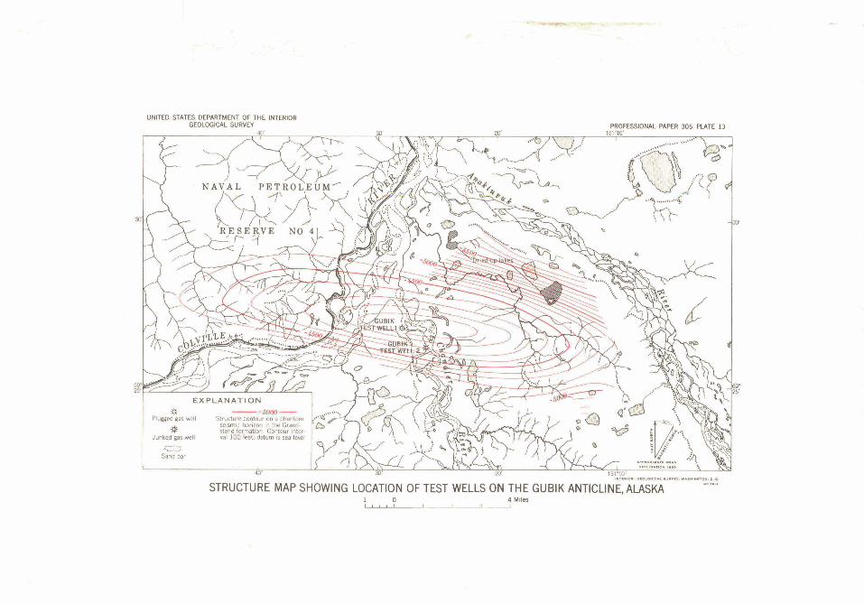
Page PLATE 13. Map showing Ohe location of test wells on the
Gubik anticline. 14. Gubik test well 1, camp, and drilling rig-.Faces 212 15. Graphio log of Gubik test well 1. 16. Graphic log of Gubik test well 2.
...
FIGURE 11. Index map of northern Alaska ------ - - - ---- 12. Cretaceous section penetrated on the Gubik . . antichne------------------------------ 13. Relative abundance of hemy minerals in tbe
Gubik test wells - _ _ - - - - - _ - - - - - - _ - - _ - - _ -
111
Page 208
EXPLORATION OF NAVAL PETROLEUM RESERVE NO. 4 AND ADJACENT AREAS, NORTHERN ALASKA, 1944-53
TEST WELLS, GUBIK AREA, ALASKA
From 1944 to 1953 the U; S. Navy, through its contractor and assisting Government agencies, explored the petroleum possibil- ities of Naval Petroleum Reserve No. 4 and adjoining are= in northern Alaska. In the oourse of this exploration, seismic, magnetic, and gravimetric'gaophysical surveys and field geologic surveys were made, and a test-well drilling program was under- taken.
Two tests were drilled on $he Cubik anticline, which is about 180 milea southeast of Point Barrow. The two wells were little more than a mile apart, and the same Upper and Lower Cretaceous rocks were penetrated. Gaa was discovered at two horizons: in the Tuluvak tongue of the Prince Creek formation, and in the Chandler and Ninuluk formations undifferentiated. Gubik teat well 1 was drilled to 6,000 feet then plugged and abandoned; Gubik test well 2 was drilled to 4,620 feet; it then blew out, caught fire, and was subsequently abandoned.
In the course of the ekloration of Naval Petroleum Reserve No. 4, n o r t h p Alaska (Robinson, 1956, p. 1-3), two test well$ were drilled on the Gubik anticline, 180 miles soutpeast of Barrow and approxi- mately 16 miles northeast 6f Umiat near latitude 6g026' N. and longitude i15I028* W. (See fig. I1 .) The Gubik anticline extends eastward between the Anak- tuvuk and Colpille Rivers across the mouth of the Chandler Riesf. The presence of the anticline was reported in 1946 by a reconnaissance geologic field party, and its structura1:featurw were later defined by geologic mapping and ref&thn seismogmph work. The name "Qubik!" is atvadant of the Eskimo word for "Big River," the n a h k name applied to the lower Colville River. I .
The test wells &re w'r54~lw gravel tenace 10-12 feet above the normaL.r&*r&e~el on the west side of the Chandler Biyer a sbort distance above its mouth. (See pL 13.) In general, the area near the confluence of the C o l d e , Chandler, and Anaktuvuk Rivers is one of low rofling hills a t the northern e+ of the nortbxn foot- hills of the Bmks Ranget Qloee to its mu&, the
Anaktuvuk River flows through a broad valley with low bluffs. The valley of the Chandler is narrower and has steeper walls, which are 50 to several hundred feet high.
The test wells were drilled into Upper and Lower Cretaceous strata. Gas in commercial quantities was found in two separate sandstone beds 1,500 feet apart stratigraphically. A detailed description of the rocks examined and the logistic, engineering, drilling, and production data are assembled in this paper.
ACKNOWLEDGMENTS
Engineering information presented here is taken largely from the weekly, completion, and final reports made to the U. S. Navy by Arctic Contractors. United Geophysical Co. did most of the geophysical work, and the Schlumberger Well Surveying Corp. recorded all but one of the electric log runs. Gas analyses were made by the U. S. Bureau of Mines at Bartlesville, Okla., and some core analyses were made by Core Laboratories, Inc., of Dallas, Tex. The help of persons connected with these organizations is gratefully acknowledged.
Lithologic descriptions and other core analyses were made by the author in the Fairbanks laboratory of the U. S. Geological Survey. Members of the Geological Survey whose work is included are Harlan R. Bergquist, who identified the microfossils; Ralph W. Imlay, who identified the Lower Cretaceous megafossils, and George Gryc, who identified the Upper Cretaceous megafossils; Robert H. Morris, who established heavy-mineral zones; and Roland W. Brown, who identiiied plant fossils. The stratigraphic distribution of microfossils in the test wells of northern Alaska will be presented by H. R. Bergquist in another chapter of this series.
STRUCTURE
The Gubik anticline was first noted by a Geological Survey reconnaissance field party dqcending. the
207
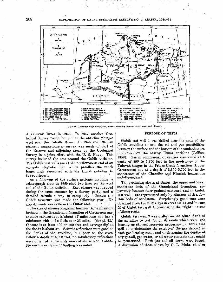
208 EXPLORATION OF NAVAL PETROLEUM RESERVE NO. 4, ALASKA, 1944-53
I SOUTH BARROW TEST WELL 1 7 SlNrSON TEST WELL 1 13 OUMALIK TEST WELL 1 19 WOLF CREEK TEST WELL 3 2 SOUTH BARROWTEST WELL 2 8 TOTAGORUK TEST WELL 1 14 VJTOUMALIK TEST WELL I M GUBIK TEST WELL. 1 3 SOUTH BARROW TEST WELL 3 I EAST TQTAGORUK TEST WELL 1 I S SQUARE LAKE TEST WELL 1 21 GUBIK TEST WELL 2 4 SOUTH BARROW TEST WELL 4 10 FISH CREEK TEST WELL I 10 TITALUK TEST WELL 1 22 KNIFEIILAOETEST WELL 1 5 AVAK TEST WELL 1 I 1 KAOLAK TEST WELL 1 17 WOLF CREEK TEST WELL t 23 KNIFEBLADE TEST WELLS 2 AND2A 6 NORTH SIMPSON TEST WELL I 12 MEADE TEST WELL I 10 WOLF CREEK TEST WELL 2 24 GRANDSTAND TEST WELL 1
9- UMIAT TEST WELLS 1-11 --
FIGURE 11.-Index map of northern Alaska, showing l o c a t i o n d test wells fand oil fields.
Anaktuvuk River in 1945. In 1947 another Geo- 1 PURPOSE OF TESTS
logical Survey party found that the anticline plunges west near the Colville River. In 1945 and 1946 an airborne magnetometer survey was made of part of the Reserve and adjoining areas by the Geological Survey in a joint effort with the U. S. Navy. This survey included the area around the Gubik anticline. The Gubik test wells are a t the northwestern end of an rlongate magnetic high, which parallels the much larger high associated with the Umiat anticline to the southwest.
As a followup of the surface geologic mapping, a seismograph crew in 1950 shot two lines on the west end of the Gubik anticline. East closure was mapped during the same summer by a Survey party, and a detailed seismic survey to completely delineate the Gubik structure was made the following year. No gravity work was done in the Gubik area.
The area of closure on seismic horizon "A," a phantom horizon in the Grandstand formation ef Cretaoeous age, extends eastward; it is about 12 miles long and has a minimum width of a little over 2% miles. (See pl. 13.) Closure is at least 400 or 500 feet and average dip on the flanks is about 3'. Seismic reflections were good on the flanks of the anticline, but poor on the crest. Below a depth of 4,000 feet, no satiefactory reflections were obtained; apparently most of the section is shale. No seismic evidence of faulting was noted.
Gubik test well 1 was drilled near the apex of the Gubik anticline to test the oil and gas possibilities between the surface and the bottom of the sands that are productive on the nearby Umiat anticline (Collins, 1958). Gas in commercial quantities was found at a depth of 890 to 1,750 feet in the sandstones of the Tuluvak tongue in the Prince Creek formation (Upper Cretaceous) and a t a depth of 3,350-3,700 feet in the sandstones of the Chandler and Ninuluk formations undifferentiated.
The producing strata a t Umiat, the upper and lower sandstone beds of the Grandstand formation, ap- parently become finer grained eastward and in Gubik test well 1 are represented only by siltstone with a few thin beds of sandstone. Surprisingly good cuts were obtained.from the silty clays in cores 42-44 and in core 51) of Gubik test well 1, considering the "tight" nature of .these racks.
Gubik tes?st well 2 was ddled on the south flank of the anticline to test for oil ih sands which were gas bearing or showed reservoir properties in Gubik test *ell 1, t6-determine the extent of the gas deposit in &ch gagbwring siand, and t6 determine the'depths of any gas-03, gas-water, or oil-water contacts that might be penetm%ed. Both gas and oil shows were found. A discussion of these shows by C. L. Mohr, chief of
TEST WELLS, GUBIK -A, ALASKA 209
exploration, Arctio Contrackors, can be found on page 254. Unfortunately, $he well blew out and was abandoned before the testing was completed.
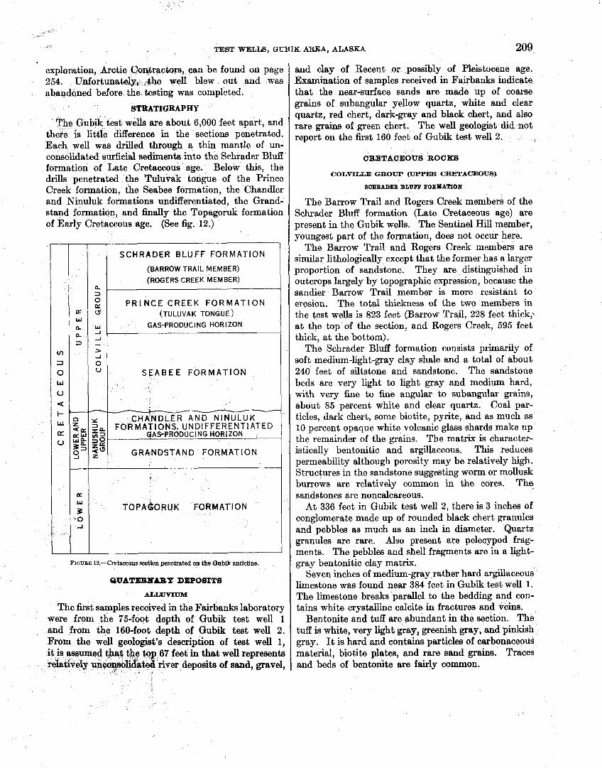
STRATIGRAPHY
The Gubik test weIls are about 6,000 feet apart, and there is little difference in the sections penetrated. Each well was drilled through a thin mantle of un- consolidated surficial sediments into the Schrader Bluff formation of Late Cretaceous age. Below this, the drills penetrated the Tuluvak tongue of the Prince Creek formation, the Seabee formation, the Chandler and Ninuluk formations undifferentiated, the Grand- stand formation, and h a l l y the Topagoruk formation of Early Cretaceous age. (See fig. 12.)
I (BARROW TRAIL MEMBER) I r 1
1 (ROGERS CREEK MEMBER) 1
SCHRADER BLUFF FORMATION
- O P R I N C E CREEK FORMATION a 0 (TULUVAK TONGUE)
w GAS-PRODUCI NG HORIZON -1 -1 - > -1
0 U SEABEE FORMATION
CHA'NDLER AND NINULUK FORMA~IONS, UNDIFFERENTIATED
QAS-PRODUCING HORIZON
GRANDSTAND FORMATION
FICUBE 12.-Cretaceous section penetrated on the Qnbik anticline.
OUATEENABZ DEPOSITS
ALrduvIuM
The first samples received in the Fairbanks laboratory were from the 75-foot depth of Gubik test well 1 and from the 160-foot depth of Gubik test well 2. From the well geologist's description of test well 1, it is assumed that the tqp 67 feet in that well represents relatively unmnsolid~tel river deposits of sand, gravel,
r I _ I
and clay of Recent or possibly of Pleistocene age. Examination of samples received in Fairbanks indicate that the near-surface sands are made up of coarse grains of subangular yellow quartz, white and clear quartz, red chert, dark-gray and black chert, and also rare grains of green chert. The well geologist did not report on the first 160 feet of Gubik test well 2.
CRETACEOUS ROCKS
COLVILLE GROUP (UPPER CRETACEOUS)
SCEBADER BLUFF BOBMATIOB
The Barrow Trail and Rogers Creek members of the Schrader Bluff formation (Late Cretaceous age) are present in the Gubik wells. The Sentinel Hill member, youngest part of the formation, does not occur here.
The Barrow Trail and Rogers Creek members are similar lithologically except that the former has a larger proportion of sandstone. They are distinguished in outcrops largely by topographic expression, because the sandier Barrow Trail member is more resistant to erosion. The total thickness of the two members in the test wells is 823 feet (Barrow Trail, 228 feet thick,. a t the top of the section, and Rogers Creek, 595 feet thick, at the bottom) .
The Schrader Bluff formation consists primarily of soft medium-light-gray clay shale and a total of about 240 feet of siltstone and sandstone. The sandstone beds are very light to light gray and medium hard, with very fine to fine angular to subangular grains, about 85 percent white and clear quartz. Coal par- ticles, dark chert, some biotite, pyrite, and as much as 10 percent opaque white volcanic glass shards make up the remainder of the grains. The matrix is character- istically bentonitic and argillaceous. This reduces permeability although porosity may be relatively high. Structures in the sandstone suggesting worm or mollusk burrows are relatively common in the cores. The sandstones are noncalcareous.
At 336 feet in Gubik test well 2, there is 3 inches of conglomerate made up of rounded black chert granules and pebbles as much as an inch in diameter. Quartz granules are rare. Also present are pelecypod frag- ments. The pebbles and sliell fragments are in a light- gray bentonitic clay matrix.
Seven inches of medium-gray,rather hard argillaceous limestone was found near 384 feet in Gubik test well 1. The limestone breaks parallel to the bedding and con- tains white crystalline calcite in fractures and veins.
Bentonite and tuff are abundant in the section. The tuff is white, very light gray, greenish gray, and pinkish gray. It is hard and contains particles of carbonaceous material, biotite plates, and rare sand grains. Traces and beds of bentonite are fairly common.
210 - -
EXPLORATION OF NAVAL bETROLETJM RBRBRVE NO. 4, ALASKA, 1944-53
The S i a d e r Bluff formation has a few microfo&fls and is probably marginal marine. A thick-shelled Inockamus, possibly I. ldbreckens i s McLeam, is present. '
PBfBCB GBSX FOBXATIOIr t
The Tuluvak tongue of the Prince Creek formation underlies the Schrader Bluff formation in the Gubik area. I t is 870 feet thick and is made up mostly of sandstone with some conglomerate, clay shale, coal beds, and bentonite.
The sandstone is light gray to meJlium light gray, soft and friable to moderately hard, and thin bedded to massive. Sandstone in the Tuluvak tongue is coarser grained than any of the older sandstones drilled in the Reserve. The grains are subangular to sub- rounded and range in size from very h e to very coarse, with a preponderance of the coarser material, including granules and pebbles. Generally, the larger sizes are better rounded. Fifty to eighty-five percent, of the sand grains is white and clear quartz, and as much as 40 percent of the total is dark-gray and black chert. The coarser-grained sandstones have the larger propor- tion of dark chert and consequently have a salt-and- pepper appearance in the hand specimen. Biotite, coal, ironstone, and white feldspar (?) particles, rare yellow quartz (?), pyrite, and rock fragments are the other constituents of the sandstone. The matrix ranges $om argillaceous and sideritic td very calcareous. In a few beds the sandstone grades to siltstone. Rare tiny worm burrows similar to those in the ~chrader Bluff formation are in the uppermost 50 feet of t h e beds. The effective porosity of the sandstone in the Tuluvak ranges from 4.4 to 25.4 percent, averaging about 15 percent, and the permeability, from imper- meable to 3,780 millidarcys. Gas is present in the Tuluvak tongue.
Conglomeratic layers in the Tuluvak tongue are not &mmon nor very thick. The conglomerate corkists of rounded granules and pebbles of black chert rtnd white quartz in a coarse sand matrix.
Twelve percent of the tongue is clay shale which is, medium light gray to medium gray and ranges from soft to hard. Most of the clay shale hk good cleavage except in the lower part of the section where some claystone is found. Bentonite is common throughout in beds as much as 2 feet thick and is also finely dis- seminated in the clay shale. This bentonite is soft, white, Very light gray, light gray, greenish gray, and bluish gray. The bentonitic shales q e softer and of lighter ?lor than the nonbentonitic C l a y shale: Ben- fbnite'ib raiely found in the matrix of the sandstones in contrast to the sandstone in the Schrader Bl& formation above, but is, in many places, closely asso- ciated with coaly or caibonaceous layers. Carbona-
ceouslaminae, partings; and plant fragmente are common in both the clay shale and the sandstone. Coal, mostly in thin beds, is also common. It is shiny to dull and black and is rather brittle. Smdl amounts of clear yellow amber occur in the coal beds. The clay shale is much darker where associated with carbonaceous mateiial. Thin hard medium-gray limestone layers are very rare. Calcite and aragonite in tiny veinlefs in the limestone and clay shale were noted. Clay ironstone nodules and lenses are common in the forma- tion. The Tuluvak'section is mostly nonmarine as suggested by the abund~lnce of carbonaceous material, cod; and plant fossils. Rowever, some pelecypods (including Imeeranzw) Foraminifera, and Radiolaria were found.
SEABEJZ FOIiMATIOB
In the Gubik test wells, 1,545 feet of marine clay shale and a small amount of silty sandstone make up the Seabee formation. In the subsurface the lithologic break between the Prince Creek and the Seabee forma- tions is placed a t the base of the major sandstone group and above a distinctive microfauna. (See p. 261.) In the type section (Detterman, in Gryc and others, 1956)) the Ayiyak member, 360 feet of marine siltstone and sandstone, is described a t the top of the Seabee forma- tion. In the Gubik test wells the upper part of the section assigned to the Seabee formation is also partly sandy anil. probably represents the Ayiyak member. However, regional correlations in the subsurface suggest that there may be a small unconformity a t the top of the Seabee formation, and because the boundaries of this member cannot be clearly defined lithologically in the subsurface a t Gubik, the term "Ayiyak member" is not used here.
The 100 feet or so of sandy beds in the uppermost part of the Seabee formation contains marine pelecypods and some microfossils. The sandstone is light to me- dium light gray, rather hard, and silty to fine grained and shows fair porosity but, ye,q _low permeability; some has very h l w e o u s dement. The sandstone contains 80 percent of white and clear quartz, and 20 percent of dark chert, rock fragments, coal particles and mica. The sandstone grades downward into silty and argillaceous beds.
Below this elastic unit is 900 feet of clay shale with scattered thin b&is£,siltshne.. .In. tb upper third of the Seabee formation the clay shale is medium light gray but becomes medium. gray lower in the section; on t&e GhoIe the shide is darker than tbe shale of other Upper Cretaceoug * a > formations.' glightly silty beds are c o e o n . + White Untonite and light-colored benton- itic shale *A& also' f0"dd. ' -.Tn'cer4e;$' parts 'of tlie 900-foot ghdy Seabee f o ~ ,
tion; 'thd'6~iy sliale is medium daik gray, breaks easily*
TE? WELLS, G W I K AREA, ALASKA 211
parallel ,to the bedding, and characteristically is associ- ated d t h thin and partings of light-colored bentoqite, $ipinae ' of limestone and aragonite, thin- shdeb @&ra~w Zubiatust fragments' and prisms, and Gbbone b a t s . These beds are probably correlative with the d q k "paper shales" that crop out in the Umiat prea'smd are litholo$cally distinctive in the' Cretaceod &t$on; The section between 3,040 and 3,100 feet id Cub& test'mfell 2 is a good example of Qese beds,
Silty clay shale, siltstone, and sandstone make up the lowest 500 feet of the Seabee formation. The lower sandstone beds of tBs formation are light; gray, h e , massiTte, and very f i e to medium grained. The 'gnih are !ubanguIar to subround, and 70-95 percent h e 'white and clecrr qwtnt; Other constituents are chdt; coal particles, rock fragments, and mica. Over a wide area these beds rest unconformably upon the Nanushuk group and closely resemble the sandstone of that group; they m y represent reworked material from the older rocks. rThey can be dzerentiated from €be mndsbnw of the &nwbuk group by the abundance of biotite plates, rocL p w t i h , and generally a very "dirty" matrix, A large part of the sandstone is silty and grades into eiltatone. Argillaceous beds are the same es those described above in the 900-foot shaly part of the Seabee. Bentonite and limestone beds and fish fragments are rare. Imcermw pisins and ffag-
+*menta are common in both the core and cuttings. Mollusike borings appear in the siltstone. "Swirly)) beds present are the result of slump or deformation at the.bime of depositionc In one core a broken Inoce~a- mus shell is embeddedivekticdly in the distorted beds. Thtb -beds are noncai~eoua 40 moderately caloaseous, and porosity is fair, but permeability is very low. They are not good reservoir rocks aaad have very few shows ofgss or oil.
. . N m m Q R ~ P GOlS%Ft AND bPPER CRETACEOUS)
Below the Seabee formation is 440 feet designated as the Chandler and Ninuluk formations undifferenti- ated. The marine Ninuluk formation is the time equivalent of tbe u p p ~ part, of the nonmarine Chandler formation (Robinson, 4956, fig. 3); $.*The upper 60 feet is definitely mariqe +neJ could be assigned to the Ninu- luk formation as both" mariqe') megafossils and micro- f~asils t y p i d of tl+e )%nuluk formation were found. However, ip the rkt of the section the proportion of marine to nommine rocks cannot be 'determined; so the entire 440 feet haa not been divided.
The sandstones of the Nanushuk group are similp to those of the Seabee formation above; sandstones of the Nanushuk, however, contain a smaller amount of
4 2 9 8 7 0 - 5 6 2
argillaceous material in the matrix and are less cq- careous. c he gain size is also slightly coarser than that in the Seabee formation. Carbonacwus ~ ~ t e r i a l and clay ironstone are more common. The break between the Colville and Nanushuk groups is picked on the basis of lithologic evidence, as well as on a major change in microfauna and a change in heae-mineral zones.
The Chandler and Ninuluk section, the lower of the two gas-producing beds in the Gubik anticline, is 86 percent of sandstone and siltstone and 14 percent of clay shale. The sandstone is light gray to medium light gray, hard, and mostly massive with irregular fracture. The grains range from silt to medium sand and are composed of 75-90 percent of white and clear quartz and varying amounts of dark-colored chert, coaly particles, mica, and rock fragments. Chalky white-weathered chert or feldspar particles, pyrite, and garnet are rare. The matrix is argillaceous and locally calcareous. At 3,603 feet in Gubik test well 1, the carbonate content is 38.3 percent by weight, but this high percentage is unusual.
The effective porosity of the sandstone beds ranges from 1.6 to 15.1 percent, and the permeability, from impermeable to 265 rnillidarcp. The sandstone at about 3,500 feet in Gubik test well 1 and at about 3,800 feet in Gubik test well 2 has the best porosity stone and permeability.
The siltstone is similar in composition to the sand- stone but is medium light gray and more regularly bedded. Crosshedding, ripple marks, and "swirly" bedding were noted. Carbonaceous partings and very rare thin shiny black coal beds are present. Nodules and laminae of olive-gray and yellowish-gray clay iron- stone are typical of the section.
The clay shale is medium to medium dark Bay and moderately hard, has good cleavage, is h e l y micaceous, and has micaceous and ckrbonaceous partings. A small amount of the shale could be called claystone as it has poor or no cleavage.
A foot of hard medium-gray limestone occurs at 3,890 feet in Gubik test well 2. This limestone contains a thin vein' of white calcite. The only occurrence of bentonite (very light gray) is in the well cuttings at about 3,655 feet in Gubik test well 1. A 3-inch bed containing abundant white oolites was found in Gubik test well 2 at 3,734 feet. The matrix and some of the oolites are very calcareous; other oolites appear to be composed of weathered chert and still others are coated wi th pyrite. , ,,
QRARDSTAXD PORYA'ROA
The transition from cha&er and ~inul&:fbr&- tions undifferentiated to the Grandstand folhnstion is gradational. The top of the predominantly marine
212 EXPLORATION OF NAVAL PETROLEUM
rands staid formation is marked app~ximately by the first appearance of the microfossils aifd'megafossils of
1 .
the Verneuilinoides borealis faunal zone. The Grandstand formation is 58(lt'feet thick and
composed of clay shale with about 30 percent of silt- stone and sandstone. The clay shale is mediuin to medium dark gray and moderately. hard and has fairly good cleavage. A small proportion of it has Poor cleavage. I t is finely micaceous and has rare ~~C~C~OUS-carbonaceous partings as in the formation above. I t is interbedded and gradational with silt- stone beds.
The remaining beds are silty clay shale, siltstone, and sandstone. The light to medium gray, On the amount of sand; the more sand the lighter the The sand grains range from very fine to fine. Eighty-five percent or more is composed of subangular to subro@ded white and clear quartz grains. The sandy, silty beds range from noncalcareous to calcareous. All beds tested were impermeable or had a permeability &f less than 1 rnillidarcy. Effective porosity ranges from 3.9 to 11.1 percent. Good oil cuts were obtained from the more elastic beds. The sandstone of the Gmndstand forma- tion can be with the beds at Umiat (Collins, 1958), but reservoir conditions, where tested'on the bubik ahticline, are much ~h~ sandstones become finer grained northeast from Umiat.
There is a trace of bentonite or bentonitic clay shale in the upper part of the arandstand fornation. ~ h i r ~ ~ percent of a ditch sample at 4,130 feet in Gub& test well 2 is light-bluisb-gray bentonite
plates of biotite and subangular grains of quartz. Clay ironstone is very rare in the section, and carbonaceous or coaly partings are upcommon.
TOPAOORUK FORMATION
The oldest ricks reached by the Gubik test wells are in the Topagoruk formation. Gubik test well 1 was drilled through 1,685 feet, which was almost ent;irely clay shale; the bottom of the formation was not reached. Much of the clay shale is silty, but less than 75 feet is siltstone. Sandstone beds are very rare. The con- tact between the Topagoruk and Grandstand forma- tions is arbitrarily drawn where a much higher per- centage of siltstone and sandstohe is qoticeable. There is no sharp break between the two formations.
The clay shale of the Topagoruk formation is mostly medium to medium dark gray, although lighter gray beds containing bentonite are present. The 'shsle is moderately hard and bas fair to excellent cleavage. Xt is silty and interbedded with numerous thin beds
. .
RESERVE NO. 4, ALASKA, 1944-53
k i d ' partings of inedium-light-gray siltstone. The proportion of silt in the clay ~'*'iicile decreases with depth, and ih ,the lowest part of the fohnation pene- trated, silt is essentially absent. The few massive siltstone beds found are medium light gray and resemble $ose of the Grandstand formation.
White bentonits and bentonitic clay shale are quite common in the upwr half of the fprmation drilled. Traces of coal also occur in this formation. Except for a dmreous matrix in a . few d t y beds, trace df 'ara%onite, and a trace of clay ironstone, carbonates are lacking in the Topagoruk f~rmation.
of 4 and Qbthind fr<m ailty beds in t&s*formation is We.60 5,441 fe& of Gub% test well 1. Megaffasils ~pd,micr~foasils of the Verneu- fio&jes faunal zone are present and the forma- tion is in o*.
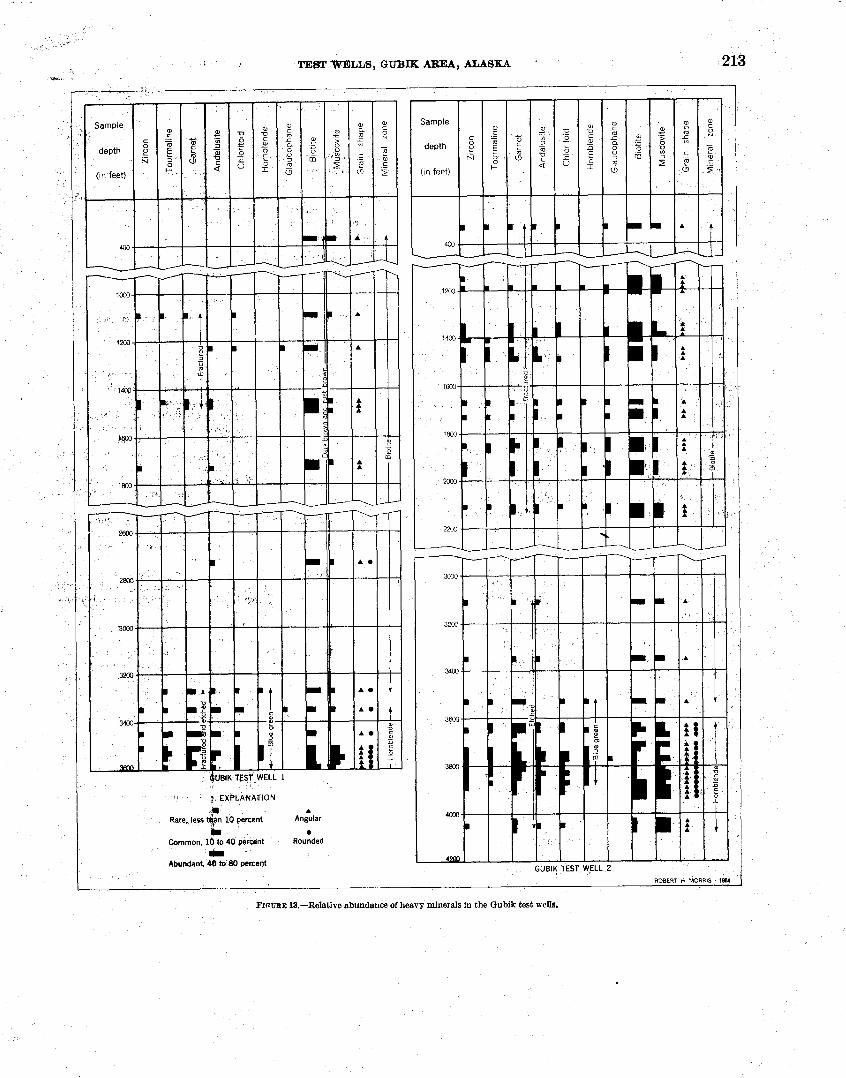
HEAVY-MINERAL STUDIES
Six@-tw~'heav~-minerai samples were taken from . the Oubik and by H. Morris 8s a part of his study of the heavy minerals of Naval Petroleum Reserve NO. 4: He eoncludes that bioti6e and hornblende heavy-miirrr~al.zones-.are repre- sented in the holes. The method of ~ r e ~ a ~ n g sam$es and a short description of the various heavy-mineral Zones (written before the Gubik were' may 'be found in and (1.851). In Gubik well 1 the biotite zone ranges from 360 to 3,280 feet, and the hornblende zone1 from 3,340 to 31600 feet. In Gubik well 2 the biotite zone rahges from 320
31540 feet1 and thehoITlblende from 31620 to 4,080 leet. The biotite zone coincides with the Colville ~OUPJ and the hornbImde zone, with the upper part of the Nannshuk group. Figure 13 shows the range and abundance of biotite and hornblende and -the other heavy *era18 which were u ~ d the
GUBIK TEST WEiL 1
~~t 69~b6t4B" N., long ~ ~ 1 0 2 8 t 0 ~ ~ W. Elevation: Ground, 144 feef; kdly bushing, 156 feet. Spudded: May 20, 1951. CoapIeM: Augmt 111 1951, plugged and abandoned. Total depth: 8,000 feet.
Gubik test well*? was .drilled on the west side of the Chandler River (see pl. 14) a little more than a mile above its junction wi.tb: the Colville River. . The latitude and longjitude gven for this well anafor Gubik test well 2 'are subject to cbrrection, because detailed topographic surveys had not been made of the area at the time the holes were located.
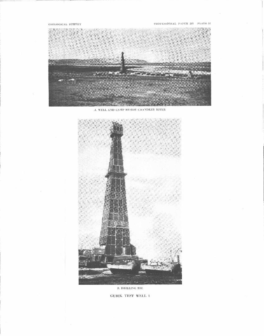
GEOLOGICAL SURVXY PI1OFESSIOZAL P.%PER 303 PLATE 14
R . I)IIlLJ.IU(7 RIG
GUHIK TEST WELL 1

TEBT WELLS, G U B I g MUU, ALASKA 2P3 *+
r
Sample
depth
(in feet)
I EXFLAWATION
1 A
Rare. less %n 10 percent Angular
ir Common. l b to 40 percent Rounded - Abundant, 40 to 80 percent
ROBERT H MORRIS . 1%4
FrnURE 18.-Relative abundance of heavy minerals in the Qubik test wells.
~214 EXPLORATION OF N A V a PBTBO~ZBLZ RESLRV% SO. 4, BLASKA, 1944-53
As could be expected near the crest of an anticline, the dip of the he&, as determined by cores from the Barrow Trail me&ber of the Schrdet Bluff formation down through tha4Gr&dstand fomation, aveages less than 2'. Many of the beds are flat lying. One notable exception is near 1,717 feet, where dips of 26'-30' are associated with dickmsides. Another exoepkn is the dip of 43O recoded at 2,513 feet, where steep slicken- sides m e also noted.
Dips in the Tsjpagoruk? formationbare much steeper, averaging lo0 or more. The rocks st 5,107 feet were fractured and have polished slicbnsided surfaces and steep dips. A few poor1 developed slickensidea were noted st 6,44& &d 6,448 kt. Dip and hole deviations arb recorded un p l a t e l
The formations in this well are given in the foVowing - table:
Formalions pre8en.j in Gubik tmt well 1
ForwUon DspU Ucd ~ ~ I O U J MU W n p ) Gubik -----,-------------------- 12-67 Schrader Bluff:
Bwrow Trail member- - ------ 67-295 Rogers Creek member: ------ - 295-890
Prince Creek, Tuluvak tongue-- - - - 890-1,760 Seabee ----------,,--- - -------- 1,760-3,305 Chandler and Ninuluk undiffer- 3,805-3,735
entiated. Grandstand . . . . . . . . . . . . . . . . . . . . . 3,73S-4,315 Topagoruk,-- - - - - -, , - - - - - - - - - - - - 4,3164,000 (tetal depth)
DESCRIPTION OF CORES AND CUTTINGS
. io8-
ohert, and rare green chert. The well geologist re- - ported the following rock depths: -
Rotary Mve bushing above ground-- ----------------- 0-12 Sand and gravel- 12-52 clay . . . . . . . . . . . . . . . . . . . . . . . . . . . - - - - - - - - - - - - - - 52-65 Goarm sand--- ---- -- -- - - - - - -- -=7-777777- - - - - - - - - 55-87 Shale-The oontact between the Gubik formation and the
Barrow Trail member of the Schrsder Bluff formation is , plaoed & 67 feet--- -- - - - ----- -- -- -- -------- -- ,-- -- - 67-75
The following well log description was msde by the author in the Fairbanks laboratory:
Lithologic description
[Whge no core b Usted, ddpt ion is based anancutting aamplas]
Clay shale, medium-light-gray, with traces of light-gray siltstone and white benton-
All depths are measured from the fop of the rotiary drive bushing, wgch was 12 feet above the surface of the ground. The material in this test and'in Gubik tmt well 2.w- dwcribed dry; colors =ere determined by comparison with the Rock Color Chart distributed by the National awearch Council ( W d a r d arid others, 1948). The term "trace" as used here means less than 3 percent and in west places less thtp 1 percent. Clsly ironstone is a dense and rather harzaideritic mudstone that generally &erve&es very dowly in c61d dilute hydrochloric ac&
The abun&&gpf microfossil spsdtnens l&d at the b* of%a&core descriptioa Ldefined follows: 1-4 v 4 ~ rw #$$I rare, 12-25 co&on, 2&5@ abun- dant, and over 50 very abundant. -
Well cut$bgs above 75 fee& were not receiied by the Fairbanks laboratory, but contamination of the highest samples received indicate that near-surface sw& are made up of coarse grains of subangular yellow quartz, white and clear quartz, red chert, dark-gray and black
ite; rare I w q m z c e pri~ms. Sandstone, very light-gay, dirty, very
fine-grained to pilty; subangular grains; contains 75 percent lestimated) white and clear quartz, 10 percent opaque white volcanic glass shards, also dark rock fragrnepts, chert, biotite and scat- tered yellow quartz, argilkaceous benton- itic cement.
Siltstone, and some very fine-grained sand- stone, very light-gray, rather hard; coaly particles in sand and ooaly part-
- - - -
----
----
----
- - - -
- ---
I ings; trace,bentonite. 135-165
W5-195
@5-235
! - -
1 - 235-265
.* - 265-295
295-345
Silty clay shale or ar@;illeceous siltstone, light- to medium-light-gky, rather hard; with biotite, coal particles, trace bpnton- ite.
Clay sbele, medium-light to medium-dark- gray; trace siltstone at top of unit.
Sandstone, very light- to light-gray, fine- grained, soft; subangular grains, 85 per- cent white and clear quartz; a h dark chert;' coal particles, biotite, rare vol- canic shrds; argillaceous bentonitic
i matrix. Inoeeramus fragment at 205215 ft.
Clay shale, medium7dark-gray, particu- larly a t base of udt , plus sandstone as above. Inoceramus at 245-a55 ft.
Siltstone, light- to medium-light-gray, sofi; black carbonaceous partings; I m - ceramw, prisms at 275-295 ft.
Clay shale, medium-light- to medium-gray, trace siltstone at 295-325 ft and 335-345 f t plus eQ percent very light- to light- g a y siltstone at 325-335 ft. Top of Rogers Creek member of Sohrader Bluff formation placed at 295 ft.
9 - TEST ~ L L S , GUBIK AREA, ALASKA 215
555-565 Siltatone, light-gray, bentonitic matrix 565575 Siltatone, light-gray, and medium-light-
gray clay shale. 575-585 S'rltstone, light-gray, bentonitic matrix. 585-595 Clay shale, very light-to light-gray, silty. 595-605 Siltstone and very fine-gain6d sandstone;
considerable amount of biotite, benton- itic matrix.
605-655 Clay shale, medium-light-gray. 656-665 Clay shale, medium-light-gray, and very
light-gray siltstone, with bentonitic matrix. , ,
665-731 Clay shale- medium- to medium-dark-gray ; trace pyrite a t 665-695 ft; trace light- gray siltstone a t 705-71 5 and 725-735 f t ; thick-shelled Inoceramus a t 675-685 ft.
731-751 Recovered 20 ft: Microfoasils abundant. 10 f t 9 in., claystone, medium-gray,
aslightly silty, hard; no cleavage but fractures roughly parallel to bedding; very rare light-gray bentonitic part- ings, but texture and color mostly uni- form; rare vermicular pyritic streaks; noncalcareous, dip lo.
7 in., bentonite, very light-gray , medium- b f t when dry, irregular fracture.
!2 ft I1 in., claystone, as above. 2 in., bentonite, light-gray with slight
greenish cast. 6 in., claystone as above. 10 in., bentonite, ligbt-greenish-gray;
medium-soft when dry; fractures easily.
4 f t 4 in., claystone, as in iirst part of this core.
751-845 Clay shale, medium-light- to medium-gray; trace of light-gray siltstone a t 785-795 and 815-825 ft.
845-890 Clay shale, medium-light- to medium- gray; rare round black-chert granules noted a t 845 ft; trace siltstone a t 866- 875 f t .
890-920 Sandstone, light-gray, fine-grained, rather - soft; 95 percent white and clear quarts; rare rock fragments, chert; pyrite fairly common, slightly calcareous; matrix argillaceous but not bentonitic. Rare medium sand grains, and rare sub- rounded bhck-chert granules; 10 percent clay shale a t base of andstone. Top of the Tuluvak tongue of Prince Creek formation placed a t 890 f t .
920-940 Clay shale, medium-gray; also fairly large amount of very fine- to fine-grained light- gray sandstone, slightly to moderately calcsreous.
940-950 Sandstone, light-gray, fine-grained; sub- angular grains. 90 percent white and
Core - - - - -
- - - -
1
- - - -
- - - -
----
Depth (feet)
8451856
355-366
86&385
I
"
, t .
385-395
395-545
54k-555
LftWk$$o WewWon-Continned
-tion > . . .
TnfF; lighbgreenish-gray, hard, dense; speckled with tiny particles of black car- b o n & % ~ ~ $ nktepial.
Sandst@rinle, light-gray, fine-grained; 90 p e r k t quart%; some dark chert; car- bon'a&&a particles.
Recovered 17 ft: Microfossils very rare. 7 f t '9 ih., smdbtone, very light- to light-
gray,yihe-krained, medium-hard, mas- sive; mostlcy subangular grains, 85 p e m n t white and clear quartz, also cod parbicles, dark chert, and a very s m d amount of pyrite and fluted opsqbe white volcanic glass shards. Matrix made up of soft light-colored beritonitic clay containing abundant b- biotite plates. Very slightly cal0grreous; dip undetermined; no shorn. At 371 f t effective porosity 14.88 percent parallel to bedding and 14.93 percent normal to bedding Samplea impermeable.
7 f t 9 in., inwbeded sandstone, 85 per- cent, and day shale. Sandstone same as described above. Clay shale is medium light to medium gray and medium hard; contains numerous particles of carbona- c e o ~ material and biotite plates, and occurs as laminae a few inches thick in th6.Ijshdstone; laminae are irregular, lenticdiw, and have erratic dips with a &ghd tendency toward swirly bed- ding in spots. A small piece of a thick-shelled Inoceramus cf. Z. lund- bredxnsi8 McLearn found a t 381 ft; dip 7O (9) ; noncalcareous; no shows.
11 in., clay shale, medium-light-gray, slightly silty; medium-soft, fair cleav- agep$art of the shale contains multi- ple;binell, elongated (flat and parallel to Mding) fragments of medium-gray clayj" very rare carbonaceous partings.
7 in., Iimetekfe, medium-gray, argillace- ous end medium hard; fractures paral- lel d bedding; contains white crystal- line calcite in a vein or fracture plane.
Sandstone, light-gray, and medium-gray clay shale.
Clay shale, medium-light to medium-gray ; trace d t h o n e a t 395-415 and 43S445 i t ; tram white aragonite a t 515-525 ft; mollusk shell fragment a t 415425 ft; chunk '6f thick - Inoceramus prisms a t 445-456 ft .
Sandstone, very light-gray, very fine- grained; eubahgular grains, 90 percent white and clear quarts, also rock frag- ments, dark chert, some volcanic shards; agillmboue bentonitic matrix.
216 EXPLORATION OF NAVAL PETBOLEUM FLESERVB 'NO. 4, ALASKA, 1944-53
- Core -
----
----
----
- - - -
3
----
Lithologic descrription-Continued
Depth (feet) I DeseripWon
clear quartz; a h dark chert and rock fragments; exceedingly rare very coarse rounded dark-chert grains, pyrite very common; argillaceous matrix, slightly calcareous.
Siltstone and very fine-grained sandstone, mediuw-light-gray
Clay shale, medium-gray and rare med:um- light-gray ; trace siltstone a t 970-980 ft .
Coal, dull to subvitreous, black; platy cleavage.
Clay shale, medium-gray; trace of medium- light-gray siltstone; about 10 ft of coal.
Recovered 20 f t : Microfossils absent. 19 ft, sandstone, light-gray with very
light-gray streaks, medium-grained, hard, partly massive; 85 percent white and clear quart%; also some dark-gray chert, rare cod grains; grains sub- angular; slightly to very caloareous cement. Very light-gray streaks r e p resent laminae in which the calcareous material is concentrated; very rare, thin partings of black carbonaceous material. Slickensides of 17' and 30' noted at 1,100-1,101 ft . Beds dip as much as 15' in the vicinity of these alickensides; dips elsewhere are vari- able, averaging about 6O. Faint odor, very pale cut and pale-yellow residue from 1,087 and 1,096 ft. At 1,087 ft, effective porosity 21.1 percent; air permeability 166 millidarcys, and car- bonate content, 9.3 percent by weight. At 1,096 f t the determinations parallel to bedding are ss follows: 7.93 percent, impermeable, and 22.04 percent by weight. At 1,096 ft, normal to bed- ding, they are 7.88 percent and im- permeable.
1 ft, conglomerate with matrix of sand- stone of same type as described above. Pebbles and granules consist entirely of black chert and white quartz with a slightly larger proportion of the former. They are well-rounded, and range from % to in. in diameter. Constituents of this conglomerate are
I well sorted, primarily medium-sired sand grains and pebbles of the size ' mentioned above, with very little of intermediate grades. Cemented by
, calcareous material. Conglomerate and sandstone, light-gray,
I medium-grained; pebbles and some gran- ules of black chert and white quartz,
1 rounded; some of the sandy matrix is 1 coarse grained.
- Core -
4
5
- - - -
----
----
- - - -
Lithologic deswiptiovt-Continued
Description
7 in., clay shale, Iight-gray, medium sofL, very bentonitic; fair cleavage. AL about 1,157 ft., 2 in. of shale im- pregnated with prismatic crystals of white calcite or aragonite in laminae parallel to bedding plane. Rest of the clay shale is noncalcareous and grades down into bentonite.
2 ft 9 in., bentonite, light-gray, argilla- ceous; similar to clay shale immedi- ately above; contains minute brown- biotite plates.
2 ft, sandstone, medium-light-gray, very fine- to fine-grained, very hard and tight; probably has siliceous rather than calcareous cement; mostly quartz; a few dark minerals including a little biotite; noncalcareous; dip lo.
8 in., bentonite, very light-gray with slight greenish cast; soft and crumbly when dry; swells to unctuous mass when moistened with water; contains numerous biotite plates.
4 ft 10 in., sandstone, medium-light-gray, similar to sandstone of core 4 but softer, very bentonitic, and contain8 more biotite; grad* into clay shale in places; dip 5'.
2 ft, clay shale, medium-light-gray, fair cleavage, medium-soft; contains streak of light-gray bentonite; noncalcare- OUS; dip 3'.
1 ft 9 in., bentonite or very bentonitic clay, very light-gray, poor cleavage, with subconchoidal fracture; biotite plates abundant.
2 f t 9 in., clay shalt-, medium- to medium- dark gray, noncalcareous, slightly bentonitic; fair cleavage.
Clay shale, medium- to medium-dark-gray; trace sandstone and clay ironstone.
Bentonite, white, and very light-gray; very bentonitic clay shale; also medium-light- gray clay shale; trace yellowish-gray-clay ironstone.
Clay shale, light-olive-gray, about a quarter of sample is subvitreous black coal; trace light-gray bentonite.
Sandstone, medium-light-gray, medium- grained, rather soft and friable; salt-and- pepper, noncalcareous; 80 percent white and clear quartz; rest dark chert and rock fragments, coal particles, white chalky material, rare biotite. Also trace coal and medium-dark-gray clay shale.
TEST WELLS, GUBIK AREA, ALASKA 217
Lit holopic description-Continued
Recovered 20 ft: Microfossils absent. Sandstone, light-grhy, tine- to medium-
grained, moderately soft to very soft and friable; subangular grains, 80 percent white and clear quartz; re- mainder mostly dark-gray chert and some white chert (?), and scattered partings and thin laminae of abundant black coal particles; slightly to mod- erately calcareous. Fleeting oil odor and slight yellow greasy stain in evaporating dish from sample a t 1,224 ft. At 1,232 f t effective porosity 20.5 percent; no permeability test was run because sample plug was too irregular. Other samples a t same depth had permeability of 407 millidarcys par- allel the bedding and 357 millidarcys normal to the bedding. Carbonate content a t 1,232 f t is 7.49 percent.
- - - - 1,238-1,248 Sandstone as above. - -- - 1, 248-1,278 Clay shale, medium-olive-gray ; up to 20
peroent sand. - - - - 1, 278-1,288 Clay shale, medium-light-olive-gray to
medium-olive-gray and light-gray fine- to medium-grained, soft, salt-and-pepper sandstone; trace of coal and very light- gray bentonite.
- - - - 1,28&1,308 . Sandstone, light-olive-gray, very fine- to fine-grained; and conglomerate with rouaded black, dark-gray, and red-chert grsaules. Sandstone slightly to mod- erately calcareous with sideritic matrix; trace bentonitic-clay shale and trace coal.
- - - - 1, 308-1,328 Siltstone, medium-light-olive-gray, non- calcareous; trace very fine sandstone and of ironstone.
-. - - 1 1,328-1,338 1 Conglomerate, very fine-grained sandstone and medium-dark-olive-gray clay shale; chert granules; trace coal.
- - - - 1, 338-1, 348 Clay shale, medium-light-olive-gray. ---- 1,348-1,358 Bentonite, very light-gray with slight
greenish tinge; also medium-light-olive- gray clay shale.
1,358-1,398 Clay shale, medium-light-gray and medium-olive-gray; trace bentbnite a t 1,358-1,378 ft; trace coal a t 1,378- 1,388 ft; trace medium-grained sand- stone a t 1,3881396 ft.
----I 1,398-1,418 Clay shale, medium-olive-gray and medium-dark-gray; also considerable amount of light-gray to pale-yelloocish- brown sandstone with sideritic matrix, salt-sndpepper, fine- to medium-grained, 80 percent quartz.
- -- - 1,418-1,444 Clay shale, medium-light-olive-gray ; trace coal.
Lithologic description-Continued I
Depth (feet) Description
I
Recovered 11 ft: Microfossils absent. 5 ft, sandstone, Light-gray, rather soft
and friable, very fine- to coarse- grained; grain size gradually becomes coarser with depth; salt-and-pepper, particularly in larger size range with white and clear quartz and dark-gray chert; some argillaceous material; scattered black plant impressions; noncalcareous.
6 ft, conglomerate, medium-light-gray; very coarse sand and granules plus a few small pebbles; size increases with depth; rather soft and friable; consists almost entirely of 50 percent light quartz and 50 percent dark sub- rounded chert granules; argillaceous to very slightly calcareous cement. This core is an excellent example of graded bedding from coarse a t base to fine a t top. Faint odor, very pale cut and very pale-yellow residue from 1,450 ft. At 1,447 ft effective po- losity, 22 percent; air permeability 376 millidarcys; and carbonate content 5.34 percent by weight. At 1,450 ft porosity 24.4 percent; sample too soft to determine permesbility and was noncalcareous.
Recovered 3 ft: Microfossils absent. Sandstone, light- to medium-light-grey,
medium-hard; grains coarse to granule size, subrounded to subangular; 50 percent white and clear quartz, 50 percent dark-gray chert, very calcar- eous cement in part; dip 4O. Faint to fair odor; very pale cut and very pale- yellow residue from 1,458 ft . At 1,458 ft, effective porosity is 7.77 per- cent, parallel to bedding, and 6.48 percent, normal to bedding. Both samples were impermeable; the car- bonate content was 25.6 percent by weight. Inoceramus prisms (in micro- fossil cut).
1,469-1,475 Recovered 3 ft: Microfossils absent. 2 f t 9 in., sandstone as above, coarse- to
very coarse-grained, rare granules; noncalcareous cement. Faint to fair odor, pale-straw-colored cut, yellow residue from 1,471 f t . At 1,471 ft, effective porosity 20 percent parallel to bedding, and air permeability 988 millidarcys; normal to bedding read- ings were 20.1 percent and 570 milli- darcys. Carbonate content at this depth 7.05 percent by weight.
3 in., coal, shiny-black with platy frac- ture.
EXPLORATION OF NAVAL PETROLEUM &W~VE'NO. 4, ALASKA, 1944-53 . , .
descript.ton-Continued
D=rwo=
Recovered 30 ft: Micmfosails absent. 5 ft,, clay shale, medium-gray to dark-
gray, , medium-hard; poor cleavage; scattered lighter colored ail* streaks; dark c ~ l o r of some portions is due to +bundance of finely disseminated carbonaceous material and a few black plant impressions.
2 ft, sandstone, light-gray, as described in lowest segment of this core; rare plant impressions. Slight petrolifer- ous odor.
3 f t 4 in., clay shale as in first part of this core, The plsnt Crednetia ekgatw Hollick found a t 1,484 f t .
9 f t 8 in., sandstone, light-gray, medium- grained, hard, maseive, irregular frac-
, ture; ~alt-and-pepper with light quartz and dark chert; other minerah rare; slightly calcareoue oemeat; dip unde- termined. Faint to fair odor, pale- straw-colored cut and pale-yellow residue from 1,491 ft. At 1,491 f t effective porosity 16.37 percent and air permeability 19 millidarcye parallel to bedding. Normal to bedding readings are 14.85 percent and 13 millidarcye. Carbonate content 13.9 percent by weight.
Sandstone, light- to medium-light-gray, fine-grained, very porous, noncalcareous; mostly white and clear quartz grains with rare chert granules; conglomeratic from 1,505-1,515 f t with very coarse sand, and subangular to rounded gran- ules of black chert, yellow chert, and white quartz.
Clay shale, very light-gray, bentonitic, and white bentonite.
Sandstone, light-gray, fine-grained; 90 percent white and elear quartz grains; slightly calcareous; 5 percent of this sample is coal.
Clay shale, dark-gray and 20 peFW~t d.
Coal, dull to subvitreous, black, flaky, some dark-gray siltstone, and trace medium-grained dark-gray sandstone a t 1,55S-1,565 ft; trace light-gray fine- grained sandstone and mediumdark- gray clay shale a t 1,575-1,585 ft.
Sandstone, light-gray, very fine- to very coarse-grained; 60 percent white and clear quartz grains, 30 percent dark-gray chert and coal particles; the grains subangular to subrounded, largest are roundest; noncalcareous, very soft, fri- able and porous. Trace coal a t 1,605- 1,615 and 1,625-1,635 ft.
Core - ----
-,--
- - - ,
11
,
'
- -_-
12
I
Corn - 10
- - - -
,---
----
---- ,,--
-,-,
U t l l o l o ~ b
Dwth (ied)
1,47&1,495
1,495-1,525
1,525-1,535
1,535-1,645
1,645-1,656
1,555-1, 585
1,585-1,645
Depth W)
1, 655
1,6551,665
1,665-1,711
1,711-1,718
1,711-1,723
1,723-1,738
Utlrologio deecription-Oontinued
DesQlption
Ssndetone as above, 20 percent dull to eubvitreous black coal and 15 percent white bentonite; trace medium-gray clay shale.
Chy shale, medium-dark-gray; trace sand- stone.
Sandstone, light-gray, fine- to very coarse- gained; fine grains mostly white quartz, as much ae 50 percent dark chert in sample a t 1,685-1,695 ft .
Rea~vered 7 ft: Microfossils absent. 1 f t 3 in., sandstone, light-gray, con-
glomerate, medium-soft and friable. The sand grains are medium-sized and subangular; 80 percent white and clear quartz grains; some mica, coal par- ticles, and dark chert; sandstone con- tains angular fragments of shiny-black coal much as 2 in. in diameter, rare rounded black-chert pebbles and angu- lar medium-gray clay fragments; ar- gillaceous cement; noncalcareous. At 1,712 f t , effective porosity 29 percent, but sample was too soft for permeabil- ity test^. Kerosenelike odor, yellow cut, and brownish-yellow residue from 1,712 ft.
4 ft 11 in., clay s u e , dark-gmy, medium- hard; good cleavage; dark color apparently due to finely disseminated carbonaceou~ material; also minute flakes of mica, some pyrite; vertical fracture; contains rare thin laminae of pale-yeWwiah-brown clay ironstone and very ram fishbone fragments; noncdcareaus. Slickensides a t base; dip of beds just above slickensides 25O, dip a t top of 8'.
10 in., sandstone, light-gray; similar to first unit of this core, with scattered pebbles of black chert only; non- calcareous; dip 30'; petroliferous odor. Immalmts~prisms in microfossil cut.
Sandstone, fine- to coarse-grained, also 20 percent coal.
Recovered 11 f t : Microfossils absent. Sandstone, light-gray, fine- to rarely
medium-grained, hard, massive; grains subrounded to angular, 95 percent wbite and clear quartz; some mica, coal, and dark chert; rock has slight yellowish stain in spots; noncalcar- eous; dip .lo. At 1,730 f t parallel to bedding, effective porosity 19.55 percent, and air permeability 39 millidarcys. It is 18.7 percent and 8 rnillidsrcys nor* to bedding. Keroaenelike , odor, yellow hut, and brownish-yelloop residue from 1,730 ft. Itwceramua prisms in microfossil cut.
!CEST -, GWIK AREA, ALASKA 219
Mtb&@& dssorlpWolccm*oed
Description Core Depth (feat) Desaiption -I I - --,
- .- .~!
--- -
---- --- - .
-- -,
- - - -
13
14
- - -,
- - - -
- - - -
Clay shale, medium-light to medium-gray . about 40 percent light-gray very fine- to ke-grained sandstone; contains scat. tered biotite and coal particles and is slightly calcareous; trace very light-gray bentonite with biotite plates.
Cley shale, medium-gray. Trace sand- stone a t 2,130-2,150 ft and 2,160-2,180 it. Trace siltstone a t 2,060-2,070 ft, 2,080-2,130 f t (moderately calcareous a t 2,110-2,130 ft), , and 2,150-2,160 ft. Trace to 10 percent bentonite or ben- tonitic clay, light gray a t 2,080-2,090 ft, 2,110-2,120 ftt and 2,150-2,160 ft. Trace coal a t 2,070-2,080 ft .
Recovered 10 ft: Microfossils absent. Clay shale, medium-gray, noncalcareous,
medium-hard, fair to good cleavage with subconchoidal fracture; lighter colored silty laminae which show small
1,73&1,760 ' ,
1,760-1,770
1,770-1,790 l17QO--1,8B0
1, €430-1, &40 . ' t
1,840-1, 856
1, 896-1,877
1,877-1, 891
i'l .
I
1, 897-1,970 ...
1,970-1,980
1,980-2,040
1 4 2 9 3 7 0 4 U
scale croasbedding; very rare scattered brown fish fragments noted; dip 0.5O.
Clay shale, medium-gray. Trace siltstone and very fine-grained sandstone a t 2,20@-2,220 ft and 2,230-2,240 ft.
Sandatone, medium-light-gray, tine- to coerse-grained, very soft; 95 percent white and clear quartz grains, with bio- tite and coal particles; noncalcareous. Trace coal and dark-gray clay shale.
Siltstone, mediumaght-gray, and light- gray sandstone; contains biotite; mod- erately to very calcareous. Top of Sea- bee formation placed a t 1,760 ft.
No sample. Clay shale, medium-light-grsy; trace sand-
atane at 1,800.1,810 ft; trace coal a t 1,810-1,830 ft.
Clay shale, medium-light-gray, and ap- - prexi-ely 40 percent very calcareous
&&tone. 9andatonq medium-light-gray, fine-grained,
pm&q very soft; grains subrounded to eubagdar, mostly white and clear quarts, m e chert and biditte; slightly oslcsrems.
Recovered' 10 ft: Microfossils absent. 3 It, tazi&tone, light-gray, fine-grained,
slightly calcamus, m&&m-soft; ex- cellenb cleavage parallel to bedding; subangular grains composed of 70 per- cent white and clear quartz; biotite and chlorite common; dark chert and rock fragments also present; dip lo or les5.
7 ft, sandstone and siltstone, light-gray, medium-soft; gf same composition as Bbove; no cleavage. This part of recovery is broken into pieces avewg- ing about Tin. in diameter. SLightly calcareous.
~ebovered 19 ft: Microfossils absent. SFftstone asd sandstone, light-gray with
fairly good cleavage in part; sandstone keq 'be-grained and 50 percent , - . 'quartz. Biotite and other mica min- erals extremely abundant; coal par- ticles also present; some dark-car- bonaceous partings; slightly calcar- eous; dip lo.
Clay shale, medium-light-gray, micaceous; cqtains traces of sandstone and silt- stone throughout.
Sandstone, medium-light-gray, fine- to m@ium-grained; angular. to subangular grains, 85 percent white and clear quartz, 15 percent dark-gray to black chert (sat-and-pepper), very small amount of yellow quartz; trace mediup-gray clay shale.
Clay shale, medium-light-gray trace very fine-grained sandstone and siltstone a t 2,-2,W ft; sandstone slightly to
- , - IG@&atety calcs~eous at 2,010-2,020 ft.
Clay shale, medium- to medium-dark- gray; chunk Iraoceramzls prisms a t 2,290-2,300 ft; trace very fine-grained sandstone a t 2,300-2,310, 2,340-2,350, and 2,360-2,370 ft; 5 percent slightly calcareous siltstone, contains biotite, a t 2,320-2,330 ft, trace siltstone a t 2,330-2,350 ft, trace light-gray clay shale at 2,39&2,400 ft.
Silty clay shale, medium-light- to medium- gray.
fjiltstone, medium-light-gray, boncalcar- eous; also medium-gray clay shale.
Clay shale, medium-gray; trace siltstone. Clay shale, medium- to medium-dark-gray. Recovered 20 ft: Microfossils absent.
Clay shale, medium-gray, medium-hard, with good cleavage, thin-bedded with lighhcolored silty laminae. Pelecypod fragments a t 2,506, 2,510, 2,511, and 2,515 ft. Three of these are a thin- shelled Inoce~.amus, cf. I. labialus Schlotheim of the Seabee formation. Brown fishbone fragment8 rare; non- oalcareous; dip 1%" in upper part of eol.e, uniformly increasing to 43' a t 2,513 f t where steep slickensides were noted, decreases to 9" at base.
Clay shale, medium-gray; 10 percent medium-light-gray siGstbne, moderately calcareous: chunk Znoeeramus vrisms a t
I a t 2,520-2,'530 ft. Trace very cilcareous siltstone at 2,540-2,550 ft; also trace aragonite and trace coal a t 2,600-2,610 I fi.
220 EXPLORATION OF NAVAL PE!l%OLETJM RIWEE&TTE 10. 4, ALSAKA, 1944-53
Con I Depth (feet) -
gray siltstone in very thin laminae and lenses in shale. Inoceramus shell frag- ment noted at 2,638 ft. Fish fragments very rare; dip less than lo.
Desmiption
-- --
17
2,639-2, 659 Recovered 19 f t : Microfossils absent. Clay shale as above but with approxi-
mately 15 percent siltstone: some s u b conchoidal fracture; poor to good cleav- age; parts of lowest 8 f t of core have good poker-chip cleavage and are slightly softer than rest of core. Inoceramus found a t 2,649 and 2,655 ft; shale noncalcareous; dip less than lo.
2,659-2,670 Clay shale, medium-gray; trace siltstone, chunks of Inoceramw prisms.
2,670-2,680 Clay shale, medium- to medium-dark-gray; trace light-gray clay shale; trace silt- stone.
2,610-2,620
2,630-2,639
2, 680-2,690 Clay shale, medium-gray; 20 percent of sample light-gray moderately calcareous siltstone.
Siltstone, light-gray, also about 40 percent clay shale, trace coal.
Recovered 10 ft: Microfossils absent. Clay shale, medium-gray, medium-hard,
noncalcareous, with good cleavage; ap- proximately 10 percent medium-light-
Clay shale, medium-gray ; trace fine- grained slightly calcareous sandstone; trace ironstone.
- - - -
grained; moderately to very calcareous; subangular grains, 85 percent white and clear quartz. Ten percent dark chert and rock fragments and approxi- mately 5 percent fairly large biotite plates speckled throughout. Clay shale is medium to medium dark gray, hard, and interbedded in thin laminae with san&tone. In part of core sand and clay show well graded beds, each cycle about 2 in. thick. Carbonate content a t 2,739 ft 15.4 percent by weight. Dip 1%'. No shows. All samples in following iable impermeable to air.
19
2,700-2,723
Core -
Clay shale, medium-gray and dark-gray ; 25 percent light-gray dirty micaceous slightly calcareous sandstone.
2,723-2,743
Sandstone, light-gray, fine-grained with
Depth (ieet)
Depth (feet)
Recovered 19 ft : Microfwils absent. Interbedded sandstone, 92 percent, and
clay shale, 8 percent. Sandstone light gray, hard, very fine to medium
some medium grains; grains subangular, 60 percent whiie and clear quarts, re- mainder mostly dark chert, coal frag- ments, and biotite; moderately to very calcareous. Also some clay shale, medium-dark-gray.
Clay shale, medium to medium-dark-gray, and 15 percent sandstone as above.
Clay shale, medium-gray; approximately 30 percent of sample is light-gray fine- grained and silty only very slightly cal- careous sandstone.
Clay shale, medium- to medium-dark-gray ; slightly silty a t 2,790-2,800 ft.
Bentonite, white, and medium-dark-gray clay shale.
Clay shale, medium-gray, very small amount of white aragonite.
Clay shale, medium-dark-gray; trace white
Effective
&OeZ?)
bentonite. Recovered 7 ft: Microfossils absent.
Clay shale, medium-gray, hard, fair to good cleavage; scattered very light-gray bentonitic partings; 2 in. bentonite at very top of core is light gray and rather hard when dry and contains numerous plates of brown
, biotite. About 1% f t from bottom is 6 in. of light-bluish-gray benton- ite, laced throughout with veins of white prismatic aragonite or calcite;
Carbon- ate can-
%%- weight)
dip 2'. Siltatone, medium-light-gray; small amount
of white-vein calcite or aragonite. Trace very light-gray bentonitic clay, 2,890- 2,900 ft. Rare Inoceramus prisms 2,870- 2,880 and 2,900-2,910 ft.
Clay shale, medium-gray and some silt- stone.
Sandstone, light-gray, fine-grained; grains subangular to subrounded, 85 percent white and clear quartz, also dark chert; very calcareous.
Clay shale, 40 percent, medium-dark-
TEBT WELLS, GUBIK AREA, ALASKA 221
Lithologic d e s o r i p t ~ n t i n n e d
Core ( Deptb(feet) I Description - I
grey, and 40 percent medium-light-gray siltstone, rest light-gray very calcareous sanddone .with trace bluish-gray clay shale.
Recovered 15 ft: Microfossils rare. 5f t , siltstone, 90 percent, very argil-
laceous, and silty clay shale. Color varies fr&n light to medium gray. The central part shows an excellent pattern of slump or swirly bedding. Impression of a small pelecypod a t very top of unit. Siltstone slightly calcareous.
10 ft, clay shale, medium-gray, hard, with fair cleavage; interbedded with approximately 6 percent irregular laminae and lenses of medium- light- gray siltstone. Carbonaceous frag- ments rare; beds very nearly flat lying; a small u~identified pelecypod a t 2,962 ft. Inoceramus prisms in microfossil cut.
Sandstone, medium-light-gray, very fine- grained, and siltstone; noncalcareous, also some medium-gray clay shale. Inowamue fragments and prisms at 2,970-2,980 and 2,990-3,000 ft.
&Itstone, medium-light-olive-gray, and as much as 50 percent silty clay shale.
Clay shale, medium-gray, silty, and small amount of siltstone.
Recovered 5 ft: Microfossils rare. Siltstone and claystone, all gradations
between these two types but pre- dominantly medium-light- to medi- um-gray hard siltstone with irregular fracture; micaceous; scattered dark carbonaceous fragments; fractured Ino- eeramua embedded vertically through- out bottom foot of recovery. Non- calcareous; beds approximately flat lying.
Sandptone, Light-gray , fine-grained, rather sofit, noncelcsreous; subangular to sub- roqnded grains, 90 percent white and c l q r quartz; remainder mostly dark chert; biotite fairly common; very rare Inveeramus prisms. Trace medium-gray c l q shale.
Sandstone and siltstone. No sample. Siltstone, medium-lightgray ; trace medi-
um-dark-gray siltg limestone. Sanddone, light-gray, fine-grained, very
slightly calcareous; 90 percent white and clear quartz grains, also dark chert, rock and coal particles, fairly common biotite; very rare Inowramus prisms.
LAthoEogic description-Continued
Core 1 Depth (feet) I Description
siltstone, medium-light-gray , noncalcar- eous. Trace medium-gray clay shale.
No recovery. Sandstone, light-gray, very fine-grained,
silty, noncalcareous. Trace silty clay shale; Inoceramus prisms fairly common a t 3,186-3,190 ft.
Siltstone, medium-light-gray; biotite very common.
Sandstone, light-gray, noncalcareous, soft; grains subangular to subrounded, 90 per- cant white and clear quartz; rest dark chert and coal particles; biotite not so common.
Clay shale, medium-dark gray; 40 percent medium-light-gray siltstone.
Sandstone and siltstone; sandstone moder- ately calcareous; some clay shale; one chunk of Inowramus prisms 3,250-3,260 f t .
Recovered 19 ft: Microfossils absent. 7 f t . 6 in., interbedded sandstone, 60
percent, siltstone, 25 percent, and clay shale, 15 percent. Sandstone is light gray, fine to medium grained, hard; 60 percent white and clear quartz; rest mostly dark chert and coal particles; chloritoid and glaucophane noted; very calcareous cement. Siltstone similar to sandstone but medium light gray. Clay shale is medium dark gray, hard, good cleavage. Sandstone and siltstone contain rare gray iron- stone nodules; certain sections contain rare small fragments of clay shale parallel to bedding; coaly, carbona- ceous partings present; moderately to very calcareous; dip low but some in- dication of cross bedding with dips in the siltstone as much as 27'; faint petroliferous odor, very pale cut and yellowish greasy stain in evaporating dish a t 3,266 f t . At 3,266 f t effective porosity 7.96 percent parallel to bed- ding, and 9.8 percent normal to bed- ding. Both sample plugs imperme- able.
11 ft 6 in., clay shale, siltstone, and all gradations, very thin beds. Clay shale is medium gray, and siltstone is medium light gray. Fair cleavage; moderately hard; moderately to very calcareous; dip )ho.
Clay shale, medium-dark-gray; one chunk Inoceramus prisms 3,290-3,300 ft. Trace to 10 percent siltstone a t 3,310-3,340 ft. Top of Chandler and Ninuluk formations undifferentiated placed a t 3,305 ft .
2% EXPLORATION OF NAVAL PETROLEUM REIBERVB NO, 4, ALASKA, 1944-53
3,342-3,3M - Retovered 19 ft: Micrdfodsils abundant. 3 ft, clay shale, medium-dark-gray, very
slightly micaceous, medium-hard, with rare carbonaceow fragmente; fair cleavage, and some subconchoidal fracture.
5 ft 10 in., siltstone and silty clay shale, medibm-light-gray, hard, with rare slightly sandy streaks. Part of the siltstone occurs ad lenees in silty clay shale; rare carbonaceous partings; beds approximately fbt lying. A Bin. segment between eiltstone and under- lying sandstone mtuked by rare small rounded black-chert pebbles.
10 f t 2 in., sandstone, lighcgray, fine- grained, silty, noncalcareous, tight, maasive, hard; grains subrounded to subangular; 90 percent white and clear quartz; rest mostly dark chert and rak coal partidea plus mica. Un- identified pelecypods (two types) as much as 1 in. in diameter preserved as brownish-coated casts a t 3,256 and 3,362 ft. A pelecypod found a t 3,360 f t is Arctica sp. Faint odor, no cut, greasy stain in evaporating dish a t 3,361 f t . At 3,361 ft effective porosity lO.75 percent parallel to bedding and 10.54 percent normal to bedding.
chert, carbonaceous particles, and com- mon biotite.
No sample. Clay shale, medium-light- gray, very rare
chips of coal. Sandstone, light-gray, and siltstone; 20
percent medium-light-gray clay shale. Siltstone, medium-lightgray, very slightly
calcareous. Trace very fine-grained ' Sandstone and clay shale. No sample. 'Siltstdne and trace of silty clay shale. Recovered 20 f t : Microfossils absent.
Sittstme, medium-light-gray, hard, with fair cleavage parallel to bedding; scattered streaks of medium-dark- gray clay shale and very fine-grained sanbtone, carbonaceous partings; rare light-yellovish-gray clay ironstone nodules; slightly calcareone to non- calcareous; dip lo, irregularities of some beds suggest small-scale local deformation a t time of deposition by slumping and (or) current action. No shpws.
- - - -
WtRob& B ~ p t i o n - C o n t i n u e d
(h 1 Depth (fe8t) Description - I Recovered 1 L f t : Microfossils absent.
7 fb., silt,s$sne as described in core im-
3,362-3,370
I mediately above; rare laminae of medium-dwk-gray slightly carbona- ceous d a y . shale. Siltstone grades downward ilrto sandstone.
3 tt. 9 in., sandstone, lightgray, very fine to fine-grained, massive, hard; irregular fracture: grains 85 percent white and clear quartz; rest dark chert, mica, and coaly particles. Carbonate content a t 3,464 f t 8.64 percent by weight; dip 2O; no ir- regular bedding. - Fair petroliferous odor, very pale cut and yellowish m y stain in evaporating dish a t 3,464 ft. At 3,464 f t effective po- rosi-by 10.24 percent parallel to bedding and 10.46 percent normal to bedding. Both samples impermeable; carbonate eontent at that depth 8.24 percent by weight.
3 in., day -shale, mediumdark-gray, hard, with fair cleavage and numerous carbonaceous and micaceous particles.
Sandstone, light-gray, fine-grained, non- catcareous; grains subangular to sub- rounded, 85 percent white and clear quartz; rest dark chert, coal particles, and mica; probably has carbonaceous partings. Trace ironstone a t 3,480- 3,4M f t .
Recovered 17 it: Microfossils absent. Sandstone, light- to medium-light-gray,
fine-grained, silty, massive, hard, tight, subangular to subrounded grains 85 percent white and clear quartz;; remainder coal particles and dark chert; mica rarely common; argil- la&ous matrix, very rare brownish- gi'ay clay-ironstone nodules in lowest 3 ft core. Beds approximately flat
' lying; faint odor, very pale cut, and 'greasy stain from 3,489 f t and very fain* odor, no cut, and greasy stain from 3,500 ft. Following porosity and permeability determinations were made:
Both samples impermeable. flandstone, light-gray, fine-grained; sub-
, angular to subrounded grains, 85 per- cent white and clear quartz; rest dark
I
, <
,% ,, .
---ti-- ,
3 e l - - 3,?@&Bod..-L -.--.--- 3gep parallel ..,..--..+..
,3#3Q n o r m a l ..-.-,,----
*4--
Q. 58 9.44
11.62 10.02
------ 0 0 0
<1
8.18 - - - . - - - - - -
4.34 - --------
TEST WELLS, GUBIK ABEA, ALASKA 223
Core Depth (feet) Descctptbn - 29 3, 502-3,519 Rwrovered 17 f t : Microfossils absent.
&idstone, light-gray, fine- to medium- grained, medium-hard, breaks parallel to bedding; subangubr to subrounded grains (moetly subangular) ; 85 percent white and dear quartz; rest mostly
. . blgck-coal particles and dark-gray , chert. Sandstone is slightly softer
and more porous than that above; bedding por ly defined but probably
r , . , . w m e a t e l y flat, lying, fair to good sour c~de-oil odor, straw-colored cut
, apd yaow residue from 3,503 and $518 ft. Foilowing pomsity and per-
. mesbilities- were determined: f I I
Effec- Air tive po- permea-
Depth (feet) roslty bility (percsllt) (W-
*sr
Carbon- ate wn-
tent (percsnt
by weight)
3,603psdk?l-.----.----- 15.14 265 1.86 3,603 normal .-..--.-.---. i5.15 70 -. - -. - -. - - 3,SH pallel-. ... . -. -. .. 13.74 43 5.77 1 8 n o . - . - - - - 13.36 35 . - - - - - . - - -
I I I
30 3,529-3,535 Recovere& 16 ftt Microfossils absent. Sandstone, light-gray; essentially same ae that in core 29 but very fine to 6ne grained and slightly harder and tight& particularly toward base. Car- bonate content 6.57 percent by weight a% 3,522 f t and 6.12 percent a t 3,532 f t ; be& approximately flat lying; no odor oe out but yellowish greasy stain 'in evaporating dish a t 3,523 and 3,532 ft. Porosity and permeability deter- mined as follows:
depth (feet)
Air
t E e r o & r G t Y - ( ~ L I N -
(percent) daroys)
Carbon- ate eon-
tent (percent
by weight)
3,535-3,555 Rewvered !&I ft: Microfossils absent. S a n W n e , light-gray, fine-grained, hard,
rnasaive; has irregular fracture approx- imately a t right mg8es to side of core; subangular to subrounded grains, 90 percent white and $1- 4uaa-t~; rest dark chert, coal particles, rare mica, and rare c u y white weathered chert particles; a j e w laminae have a larger propostian of dark minerals. Bedding &UIB but beds probably flat lying.
I Depth (feet) I lxscription
No odor or cut but a greasy film as residue in evaporating diih a t 3,542 and 3,548 ft. Porosity and perme-
I I ability determinations made a t same depths:
Depth (feet)
Air Effec- parmea-
tlve PO- biUty rosity (mull-
@arcsnt) darcys)
Oarbon- ate con-
tent (percent
by weight)
3 9 1 parallel ---.--.-..-. 3 - - 3,648 psrallel---.----.-.. 3,648normal-..-.-_-----.
subangular to subrounded; most con- stituents as in core above. Quartz, 85 percent; rare dark carbonaceous-mica- ceous partings; very rare slightly yel- lowish-gray ironstone concretions; a
3, 555-3, 567
few thin medium-gray clay shale lam- inae in last 14; f t of core; essentially noncalcareous. Beds flat lying; no odor or cut, but a greasy film residue in evaporating dish, at 3,559 ft. At 3,559 ft effective porosity 13.65 per- cent parallel to bedding and 13.32 per- cent normal to bedding; air permea- bility 32 and 24 millidarcys respec- tively, and carbonate content 7.5 percent by weight.
13.11 13.34 14.10 13.10
I I I
Recovered 12 f t : Microfossils absent. Sandstone, light- to medium-light-gray,
very fine- to fine-grained, hard, mas- sive; tighter than in core above; grains
3, 567-3,586 1 Recovered 19 ft: Microfossils absent. 3 ft, sandstone, light-gray, massive,
hard, same constituents as above but more argillaceous material; noncal- careous; beds flat lying.
29.0 m.0 27.0 18.5
16 ft, sandstone, light-gray, fine- to medium-grained, noncalcareous t o slightly calcareous, medium-hard; has tendency to fracture roughly parallel to bedding giving a pseudo poker- chip effect; 75 percent white and clear
5.67 ----------
6.14 ----------
quartz grains; rock fragments and dark chert, 15 percent (salt-and-pepper) in part); rest is white weathered chert, mica, garnet, and a small amount of other minerals; very rare coaly part- ings; beds approximately flat lying. Faint odor, no cut, greasy film from 3,571 f t and faint odor, very pale cut, and greasy film from 3,580 ft. Follow- ing porosity and permeability deter- minations made:
EXPLORATION 0 j ~ A V A L P@'Ro&~M 'Wh33CRVE NO. 4, ALASKA, 1944-53
Core - - 7
34
35
- - - -
- - - -
- -- -
- - - -
LithoZobio descriptCm-Qofltinued
Description
siltstone, medium-light-gray, argilisceous; rare pebbles, granules and very coarse grains of rounded black chert. Also 30 percent very light-gray bentonite.
Siltstone, medium-light-gmy, noncal- careous, and trace to 10 percent light- gray fine-grained very calcareous sand- stone.
Sandstone, very fine-grained, and siltstone. Siltstone, medium-light-gray, argillaceous,
and some soft light-gray clay 3,790- 3,795 ft. (nonbentonitic).
Recovered 1 ft: Microfossils absent. Clay shale, medium-light-gray, noncal-
careous, medium-hard, with good *
cleavage; very thin silty laminae; me- dium-gray slightly micaceouecarbo- naceous partings; dip 2'.
Clay shale, medium-gray ; tram of siltstone 3,7104,715 ft and 3,730-3,735 f t ; trace coal a t 3,710-3,715 ft.
Siltstone, medium-gray- very fine-grained; sand streaks toward base; as much as . 40 percent medium- to medium-dark- gray clay shale. Top of Grandstand .. formation placed a t 3,735 ft .
Recovered 20 ft: Microfossils absent. 14 ft, claystone, medium-light- to
medium-gray, hard, incipient or no , cleavage; contains much micaceous
and some carbonaceous material; silty toward base. Suggestion of swirly bedding a t 3,770 f t , slickensides of 50' a t 3,770>$ ft; slightly calcareous; dips reach a maximum of 6'.
6 f t , clay shale and siltsto~e, medium- light- to medium-gray, very silty; essentially as in upper part of this core, but with slightly better cleavage and with better defined alternation of silty and clayey beds. silty layers slightly calcareous.
Recovered 1 ft: Microfossils absent. Siltstone, medium-light to medium-gray,
hard, has poor cleavage; micaceous- argillaceous partings and laminae; slightly calcareous. Maximum dips of lo0 suggest crossbedding. NO shows.
Siltstone, medium-light-gray, aandy, and 20 percent medium- to medium-dark- gray clay shale.
Silty clay shale, medium-gray ; trace coal and trace white vein aragonite or calcite.
Sandstone, light-gray, fine-grained, rather soft; grains subangular to subrounded; 85 percent white and clear quartz;
)rest is dark chert, rare coal particles, and some pyrite; also siltstone and some clay shaie, with very rare Inoceramus prisms.
Core
- - - -
- - 1 -
- - - - - - - -
36
- - - -
- - - -
37
38
- - - - '
' - - - -
' ' ' '
- - -
'
'
Lithologic
Depth (feat)
I (
3,5863,602
3, 602-3, 608
3,608-3,623
3,623-3, 633
3,633-3,643
3, 643-3, 653
description-Continued
Descdptlon Depth (feat)
3,653-3,663
3, 663-3, 680
3,680-3, 685 3,685-3,702
3, 702-3, 707
3,707-3.735
3,735-3, 762
3, 762-3, 782
3,782-3,783
3,783-3,795
.
3,795-3,810
3, 81@%, 820
1
.
Carbon- ate con-
tent (percent
by weight)
7.41 ----------
11.60
Air permea- bility (milli-
darc~s)
----------- 8.6 . .
<I-------------- Sample unsnit-
able.
Depth (feet)
----- -
3,571 parallel .... 3,571 normal ..-.. 3,580 ...-..---.-.
Effec- tive po- rosity
(percent)
1 11.38 12.30
Recovered 15 ft: Microfossils absent. Sandstone, light-gray, fine-grained,
slightly ~a1careous to noncalcareousi hard, massive; not as soft and does not have the distinctive fracture as in core above; grains subangular to sub- rounded, 85 percent white and clear quartz; rest is dirk chert, rock frag- men% weathered white chert, biotite (quite common), and very rare car- bonaceous partings. Becomes finer %'rained toward the base: dip 1'. Fair to good kerosenelike odor, pale-straw- colored cut and yellow residue from 3,594 and 3,598 ft. All samples in the following table were impermeable to aIr.
Depth (feet)
3 p e l ......... 3,594 normal.. -. . . . . . -. ....- - 3,598 paraklel -.......-.....--- 3,598 normal.. - - -- -. . -. .- ..- --
Recovered 4 ft: Microfossils absent. Sandstone, medium-light-gray, very fine-
to fine-grained, very calcareous, very hard; irregular fracture; constituents similar to above; biotite quite com- man; nearly a sandy limestone. Dip 1'; no shows. Carbonate content a t 3,603 ft 38.3 percent.
Sandstone, light-gray, very fine- to fine- grained; 85 percent white and clear quartz; grains subangular to subrounded; also dark-gray chert, coal particles, and biotite. Very cdcsreous but softer and noncalcareous in bottom 10 ft. Trace medium-dark-gray clay shale.
Siltstone, medium-light-gray, and slightly calcareous sandstone.
Clay shale, medium- to medium-dark-gray; 20 percent siltstone; trace subvitreous black coal.
Siltstone, medium-light-gray, argillaceous, slightly calcareous, and medium-gray clay shale; trace coal.
Effective porosity (percent)
11.10 10.75 10.20 10.45
Carbon- ate con-
'Zt(ged- weight) -
1% 45 . - .. - -. . . . -
15.10 ---- -. - -. . --
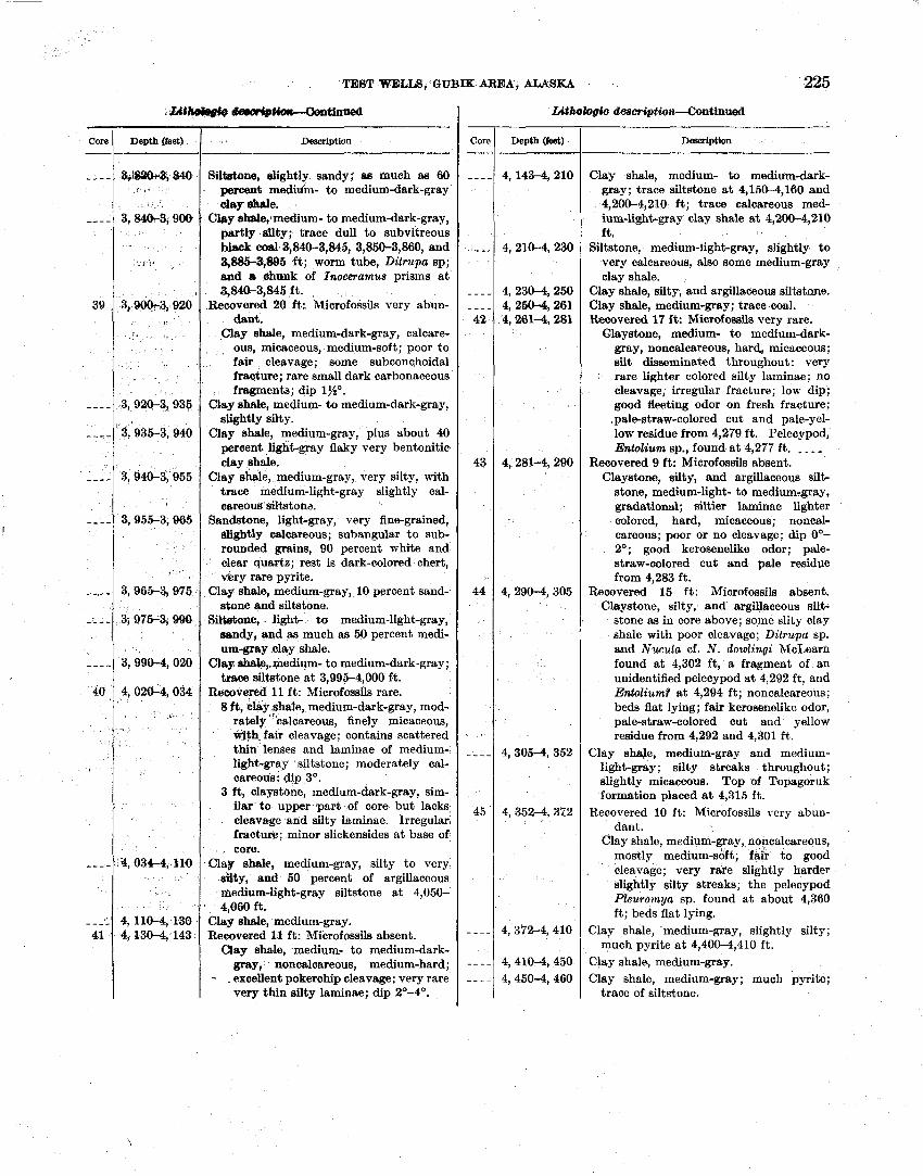
TEEIT WELLS, GUBIK AREA, ALASKA "225
;bttWr@e tiimM?-tlrmed
Core 1 Depth (~eet) 1 a Dewription
Siltatme, slightly sandy; as much as 60 percent medidm- to medium-dark-gray clay shale.
C b y shale,~medium- to medium-dark-gray, partly sWy; trace dull to subvitreous black coal, 3,840-3,845, 3,850-3,860, and 3,8853,895 ft; worm tube, Ditrupa sp; and a &ank of Inoceramus prisms a t 3,840-3,845 f t .
Rewvered 20 ft: Microfossils very abun- dant.
Clay shale, medium-dark-gray, calcare- ous, micaceous, medium-soft; poor to fair cleavage; some subconchoidal fracture; rare small dark carbonaceous fragments; dip lj.io.
3,920-3,935 Clay shale, medium- to medium-dark-gray, slightly silty.
'3,935-3,940 Clay shale, medium-gray, plus about 40 percent light-gray flaky very bentonitic clay shale.
Clay shale, medium-gray, very silty, with trace medium-light-gray slightly cal- careous siltstonz.
Sandstone, light-gray, very fine-grained, slightly calcareous; subangular to sub- rounded grains, 90 percent white and clear quartz; rest is dark-colored chert, very rare pyrite.
Oay shale, medium-gray, 10 percent sand-
Core / Depth (feet) I Desaiption
stone and siltstone. 3, 975-35 890 , S M n e , Jight- t o medium-light-gray,
Clay shale, medium- to medium-dark- gray; trace siltstone a t 4,150-4,160 and 4,2W4,210 ft; trace calcareous med- ium-light-gray clay shale a t 4,200-4,210 ft.
Siltstone, medium-light-gray, slightly to very calcareous, also some medium-gray clay shale.
Clay shale, silty, and argillaceous ailtstnne. Clay shale, medium-gray; trace coal. Recovered 17 f t : Microfossils very rare.
Glaystone, medium- to medium-dark- gray, noncalcareous, harcl, micaceous; silt disseminated throughout: very rare lighter colored silty laminae; no cleavage, irregular fracture; low dip; good fleeting odor on fresh fracture: .pale-straw-colored cut and pale-yel- low residue from 4,279 ft . Pelecypod, Entolium sp., found a t 4,277 f t . - . _ ,
Recovered 9 ft: Microfossils absent. Claystone, silty, and argillaceous silt-
3,9904,020
4,0264, 034
8,034-4, 110
4, 110-4, 130 4, Z30-4, 143
stone, medium-light- to medium-gray, gradational; siltier laminae lighter colored, hard, micaceous; noncal- careous; poor or no cleavage; dip O0- 2O; good kerosenelike odor; pale- straw-colored cut and pale residue from 4,283 ft.
Rewvered 15 ft: Microfossils absent. Claystone, silty, and argibeeous silt-
stone as in core above; sqme slity clay shale with poor cleavage; Ditrupa sp. and Nucula cf. N. dowlingi McLearn found a t 4,302 ft, a fragment of an unidentified pelecypod a t 4,292 ft, and Enbolium? a t 4,294 ft; noncalcareous; beds flat lying; fair kerosenelike odor, pale-straw-colored cut and yellow residue from 4,292 and 4,301 ft.
sandy, and as much as 50 percent medi- um-gray clay shale.
Clay shale,,l;nedium- to medium-dark-gray; trace silbtone a t 3,995-4,000 f t .
Recovered 11 ft : Microfossils rare. 8 ft, clay ahale, medium-dark-gray, mod-
rately "'calcareous, finely micaceous, %th. fair cleavage; contains scattered thin lenses and laminae of medium- light-gray siltstone; moderately cal- careous; dip 3'.
3 ft, claystone, medium-dark-gray, sim- ilar to upper pafi of core but lacks cleevwe and silty laminae. Irregular fracture; minor slickensides a t base of core.
Clay slrale, medium-gray, silty to very s&y, and 50 percent of argillaceous medium-light-gray siltstone a t 4,050- 4,060 ft.
Clay shale, medium-gray. Rewvered 11 ft: Microfossils absent.
Clay shale, medium- to medium-dark- gray, noncalcareous, medium-hard; - . excellent pokerchip cleavage: very rare very thin silty laminae; dip 2O-4'.
Clay shrJe, medium-gray and medium- light-gray; silty streaks throughout; slightly micaceous. Top of Topagoruk formation placed a t 4,315 f t .
Recovered 10 ft: Microfossils very abun- dant.
Clay shale, medium-gray, noncalcareous, mostly medium-soft; fair t o good cleavage; very rafe slightly harder slightly silty streaks; the pelecypod Pleuromya sp. found at about 4,360 ft; beds flat lying.
Clay shale, medium-gray, slightly silty; much pyrite a t 4,400-4,410 f t .
Clsy shale, medium-gray. Clay shale, medium-gray; much pyrite;
trace of siltstone.
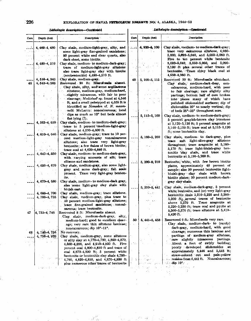
'2% EXPLORATION OF:1T&VAb P E T B O m N.C)i 4, ALASKA, 1944-53
C~re - -, ,,
-- - -
.,,, 46
,,,,
,,,-
,-,,
,,,,
,,--
---- -- --
47
48 ,,,,
Dea~iptlon
Clay sha;te, inedium- tcu d u ~ b d S r k - g r a y ; trace very c~bareous siltstone, 4,980- 5,000, 5#26-5,040, and 5,050-5,060 ft. Five >to %en percent white bentonite 5,039-6,040, 5,050-5,060, and 5,090- 5,100 f t pius several other traces of bentoaife. *Trace shiny black coal a t 4,0664.,960 It.
~eco-red 10 ft: Microfoeaila abundant. elhale, ' medium-dark-dray, non-
calcareous, medium-hard, with poor to fair cleavage; rare slightly silty partings; bottom half of core broken into pieces many of which have polished slickensided surfaces; dip of slickensldes 30' to nearly vertical; dip of beds 25'55' throughout core.
Clay shale, medium- to medium-dark-gray ; 6 percent grayish-brown clay ironstone at 5,120-5,130 ft; 5 percent aragonite a t 5,140-5,150 ft; trace coal a t 5,115-5,120 ft; some bentonitic cIay.
Clay Shsle, medium- to dark-gray, plus trace scbft light-olive-grsy siltstone %mughout; trace aragonite a t 5,160- 5,170 ft ; trace light-bluish-gmy ben- tonitio 'clay shale, and trace white bentonite a t 5,19&5,200 ft.
Bentonite,' white, with few brown biotite plates, approximately 40 percent of sample; also 30 percent bentonitic light- bluish-&ray cby shale with brown biotite plates; 30 percent medium-dark- gray chY *a
Clay shale, medium-dark-gray, 5 percent white bentonite, and (or) very light-gray bentonitic ahale 5,210-5,BO and 5,290- 5,300 ftk,e&veral traces of bentonite above 5;370 ft. Trace aragonite a t 5,220-5,230 f t ; trace coal and pyrite a t 5,360-5,370 ft; trace siltstone a t 5,410- 5,420 ft.
Reaovered 9 ft: Microfossils very rare. Clay shale, mediumdark- to (rarely)
dark-gray, medium-hard, with good cleavage; numerous thin laminae and partings of medium-groy siltstone, rare slightly micaceous partings. About a foot of swirly bedding; poorly developed sliakensides a t approni-tely 5,446 and 5,448 f t ; straw-colored cut and gale-yellow
8 b residue from 5,441 ft. Noncalcareous; a . dip lo0.
13-
Depth ( f a )
4,468-4,480
4,480-4,510
4, 6143-4, ti43 4,5434,563
4,563-4,61.0
4,6104,640
4,6404,650
4,6504,670
4,6704,680
4, 680-4, 700 4, 700-4, 735
4, 735-4, 746
4, 74%-4, 756.: 4,75614,925)
fAbr0
,-L&
49
- - --
----
-- - -
-- --
50
,
'
- Ddpti~ZU
Clay shah, medium-ligktgray, silty, and some light-gray fine-grained sandstone; 80 percent white and clear quartz, also dark chert, some biotite.
Clay shale, medium- to medium-dark-gray; trace. of medium-lwt-@y siltatone also tnce light-grey clay with biotite (nonbentonitic) 4,490-4,510 ft.
Clay hale, medium-gro)~. Rekvered 20 ft: Mbrofomila abeent.
Clay shale, silty, and;mme srgih&ous siltatone, medium-gray, medium-hard,
.slightly micaceous, with fair to poor cleavage; Maliolus? sp. found a t 4,546 ft, sad a small pelecypod a t 4,559 f t is identified as Nemodon cf. N. nzeeon- nelli McLaren: noncalcareous; local dip8 tus much as lo0 but beds almost bt lying ( 9 ) .
Clay shale, medium- to mediumdark-gray: traae to 5 percent 'lmedium-ligh-y siltatone a t 4,5906,600 ft.
Clay shale, medium-gray; trace to 10 per- cent mdium-light-&ray n o n d w m u e siltstone; also trace very light-gray bentonite; a few flakes of brown biotite; trsee aoal a t 4,6204,640 ft.
Clay @hale, medium- to medium-dark-gray, with varying amount8 of silt; trace s i l h n e and sandstone.
Clay ah&, medium-gray, also some light- gray end some dark-gray; fish s d e present. Trace very light-gray benton- ite.
Clay shale, medium- to medium-dark gray, a h some light-gray clay shale with blui& cad.
Clay shale, medium-gray; trace siltstone. Clay shale, medium-gray, plus trace to
40 peraent medium-light-gray siltstone; trace he-grained awdstone; noncal- aareoua; trace bentonite.
Recovered 8 ft: Microfoasils absent. Clay ahale, medium-dark-gray, silty,
medium-hard; good to excellegt cwv- age; very rare thin siltstone laminae; noncalcareous; dip lo0-llO.
No recovery. Chy shale, medium-gray, some siltstone
or silty clay a t 4,7704,780, 4,860-4,870, 4,880-4,890, and 4,910-4,920 ft. Five percent coal 4,800-4,$10 f t and trace of coal 4,8704,890 ft; 5 perwqt white bentonite or bentonitic clay shale 4,780- 4,790, 4,820-4,830, snd 4,870-4,8W ft plus numerous other'traces of bentonite
Depth (feet)
4 9!&l-& 100
5,100-5, 115
5,115-5,160
5,160-5, 200
5,20&5,210
5,2104,441
5,441-5,458
!
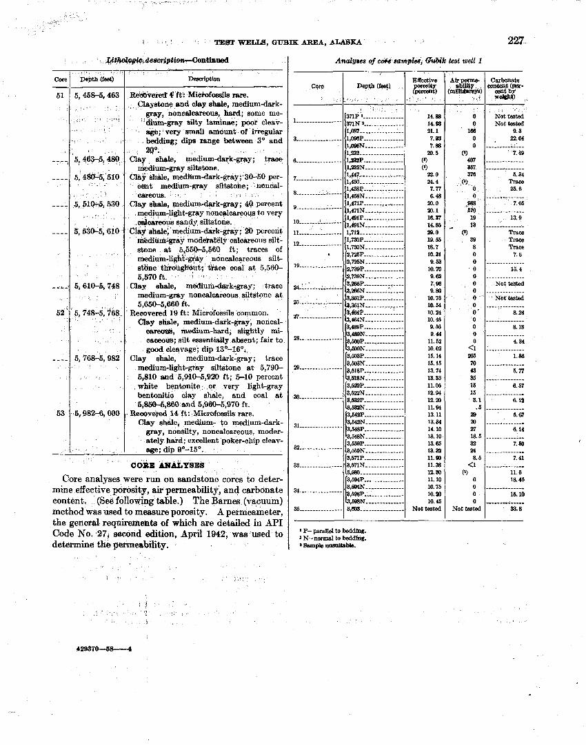
TEST WELU, GUBIK ARE1A, ALASKA 227
~ ~ 4 ~ , d e ~ p t i ~ n t i a o e d
De8crIptlon
R a v e & 9 ft: Mic)ofossils rare. Claystone and clay shsle, medium-dark-
gray, noncalcareoua, hard; some me- ' &am-gray silty laminae; poor cleav-
age; very amall amount of irregulak bedding; dips between 30 and 20".
Cla? shale, medium-dark-gray ; tracre medium-gray siltstone.
Clay shale, me&m-dark-gray; 30-50 per- ognt medium-gray siltstone; noncal- C86eOU8.
Clay shale, medium-dark-gray; 40 percent medium-light-gray noncalcareoua to very dca&ous sandy siltstone.
Cia9 shale; mediumdark-@ay; percent m.&itirh-gray moderately calcareous silt- stone a t 5,55&5,56Q ft; traces of medium-light-&ay noncalcareous silt- s h e thirs~L@tit; i r ~ c e coal a t 5,560- 5,570 ft. 3 I
Clay shale, meilium-daick~gray; trace medium-gray noncalcareous siltstone a t 5,650-5,660 ft.
Recovered 19 ft: Microfossils common. Clay shale, medium-datk-gray, noncal- csrebn8, medium-hard, slightly mi- caceous; silt ementidy absent; fair t o good cleavage; dip 13°-160.
Clay shale, medium-dark~gray; trace medium-light-gray siltshone a t 5,790- 5,810 m d 5,9&04,920 ft; 5-10 percent white bentonite or very light-gray bentonitic clay shale, and coal a t 5,850-5,860 and 5,960-5,970 ft.
. Reooveyed 14 f t : Microfmila rare. Clay shale, medium- 60 medium-dark-
gray, nonsilty, noncalcareoue, moder- ately hard; excellent poker-chip cieav- age; dip 0O-15O.
CO&X M ~ Y S E S
Core
51
- - - ,
- ---
----
--..
- A -,
52 '
- - - -
63
Analyses of c o ~ s aampha, G%M-k test well 1
Core analyses were run on sandstone cores to deter- mine effective porosity, air permeability$ and carbonate content. (See following table.) The Barnes (vacuum) method was used to measure porosity. A permeameter, the general requiremenfa of which are detailed in API Code No. 27, second edition, April 1942, was used to determine the permeability.
Depth (feet)
5,&&5,463 ,
< : . 1'1 ,
i
' 5,463-5,480,
5, 48015,'510 '
5, 510-5, 530
5, 630-5, 610
5, 610-f& 748
' 5, 7423-5, 'ii68-
5,7623-5,982
$8826,000
Core Depth (feet) '
- 1 s
Effective
! I P '
371P 1 --------------- I-------------+--- 37lN 2 ---.-.---------
: i;Emz z$ 8 8ample mm~tab~e.
14.88 14.93 21.1 7.93 7.88
20.6 (8)
(8 )
22.0 24.4 7.77 6.48
20.0 20.1 16.37 14.85 29.0 19.55 18.7 10.31 9.53
10.10 9.62 7.9s 9. SO
10.76 la 54 10.24 10.48 9.66 9.44
11.52 10.02 15.14 16.16 13.74 13.35 11.06 12.94 12. 20 11.94 13.11 13.34 14.10 13.10 13.65 13.32 11.90 11.38 la ao 11.10 10.76 10.20 10.46
Not tested
3 -----------------
.
7 -------_---------
8- - - - - - - - - - -- - - - - - _-----_----------
10. - . - . - - - . . - - . . . . 11 ................
----------------
Air perme- ability
(min-1 3 ' 1
I 1,037 ---- --------- --- 1,OBsP --..----..---.- 1,006N- - -- ---------- 1,232 ------------.--- 1 , - - I , l p 2 N ............-. 11447----------------.. 1,458- - -.---.- -.-..--
1,491P ....-.----.---- 1,491N -.---- --------
'1,712 ............. ... 1,730~ ---------------
{l,730N.. . ......... ..
Carbonate cariteat (per-
centby weleAt)
0 0
166
O , 0
(9 407 367 376
(9 0 0
.Y 670 19
, 13 0
39 8 0 o o 0 o 0 0 o 0 ' o 0 o o
<I 286 70 43 36 16 15 3.1
. 5 29 20 27 18.5 32 24 8.5
<1 (8)
o 0 0 o
Not tested
Not tested Not tested
9.3 22.61
-.-...--. , .-.- 7.49
- - - - - - - . - - . . - . - - - - - -- - - - - - - -
5.34 Tram 25.6
- - - - -? .- - - - - - 7.05
- - -- --. - - .- -- - 13.9
.----...--..-. ~ r s c e Trace Trace
7.6 - - - - - - . - - - - - - -
15.4 . - - - -. - . . - - - -.
~ o t t e s t e d - - - - - - - - - - - - - - ' Nbt tested
- - - - - - - - - - - - - - 8.24
- - - - - - - - - - - - - - 8.18
-. - - - . - - - - . - . - 4.34
- - - - - - - - - - - - - - 1.86
- - - - - - - - - - - - - - 5.77
- - - - . - - - - - -- - - 6.57
- - - -. - - - - - - --- 6.1'2
-------------- 6.67
- - - - - - - - - - - - -- 6.14
----- ----- ---- 7.60
- - . - . - - - - - - - -. 7.41
- - - - - - - - - . -- -- 11.6 1% 46
---- - --- - - - - - - 15.10 ---- --------- 87.8
Is----------------
% -----
2.5 - - - - - - - - - - - - - - - - 27 --------- ---- --- ,464N -------- ------
*---------------- +WON - - - - - - - - - - - - - -
B----------------
~,E~BP --------------- 3,603N -------------- 3,618P .... .. ..-..---- I a,mN ....-.-.--...-
a ----------------
3l ----------------
32 ----------------
n -..-..-.--.----
35 -.-----.--------
3,594~ .-..-..--. ----- 31689N-------------- 3,698P ..---_-_------- 1 ,MN- --- --------- - 3,803 --..-----...-.--
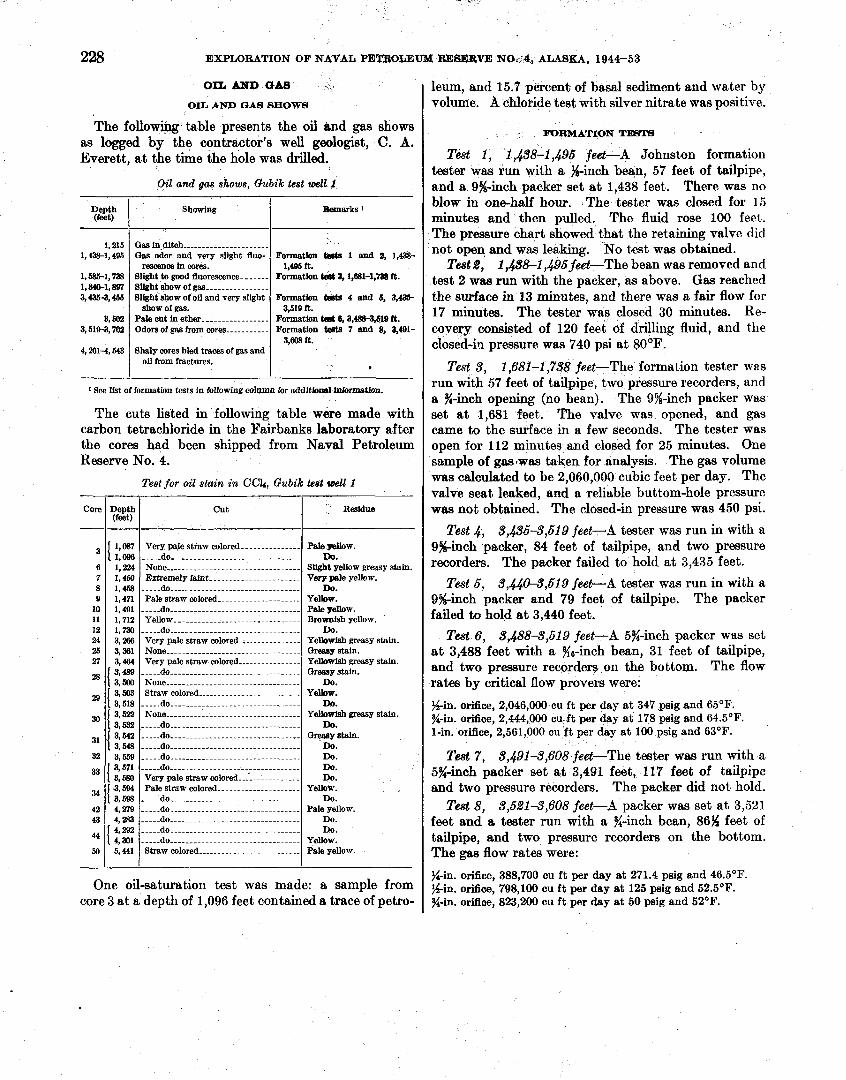
-' y *
Bemarks 1
Formatbn t W d 1 and 2, 1,438- 1,495 ft.
Formatbn 3.1.881-1,' ft.
Formation ssts 4 and 5, 3,435 3,519 it.
Formation tent 6,3,4883,619 19. Formation tPsts 7 and 8, 3,491-
3,608 it.
*
Depth
1,215 1,438-1,495
1,5854,738 1,840-1, W 3,4354,455
3, Wa 3,5194,702
4,2814,543
Showing
...................... Gas in ditch Gas odor and very slight fluo-
rBSC8nca In cores. Slight to good fluorescence- -.---- Slight ~ h o w of gas ................ Slight show of oil and very slfgbt
show of gas. ................ Pale cut in ether-
Odors of gas from cores --.----.---
Shaly cores bled traces of gas and oil from fractures.
I I I
One oil-saturation test was made: a sample from core 3 at a depth of 1,096 feet contained a trace of petro-
RESERVE N02'4, ALASKA, 1944-53
leum, and 15.7 percent of basal sediment and water by volume. A chloride test with silver nitrate was positive.
rnRMATI0N TE8T8
Test 1, 1,438-1,495 feet-A Johnston formation tester was run with a %-inch bean, 57 feet of tailpipe, and a 9%-inch packer set a t 1,438 feet. There was no blow in one-half hour. The tester was closed for 15 minutes and then pulled. The fluid rose 100 feet. The pressure chart showed that the retaining valve did not open and was leaking. No test was obtained.
Test 2, 1 ,&8-1,495 feet-The bean was removed and test 2 was run with the packer, as above. Gas reached the surface in 13 minutes, and there was a fair flow for 17 minutes. The tester was closed 30 minutes. Re- covery consisted of 120 feet of drilling fluid, and the closed-in pressure was 740 psi a t 80°E'.
Test 3, 1,681-1,738 feet-The forma tion tester was run with 57 feet of tailpipe, two pressure recorders, and a %-inch opening (no bean). The 9%-inch packer was set a t 1,681 feet. The valve was opened, and gas came to the surface in a few seconds. The tester was open for 112 minutes and closed for 25 minutes. One semple of gaswas taken for analysis. The gas volume was calculated to be 2,060,000 cubic feet per day. The valve seat leaked, and a reliable buttom-hole pressure was not obtained. The closed-in pressure was 450 psi.
Test 4, 5,&5-3,619 feetW.4 tester was run in with a Ssinch packer, 84 feet of tailpipe, and two pressure recorders. The packer failed to hold a t 3,435 feet.
Test 6, 5,&0-3,619 feet-A tester was run in with a 9$%inch packer and 79 feet of tailpipe. The packer failed to hold a t 3,440 feet.
Test 6. 3,488-3,519 feet-A 5%-inch packer was set a t 3,488 feet with a %s-inch bean, 31 feet of tailpipe, and two pressure recorders on the bottom. The flow rates by critical flow provers were:
s i n . orifice, 2,046,000 cu ft per day at 347 psig and 65OF. %-in. orifice, 2,444,000 cu-ft per day at 178 psig and 64.5OF. 1-in. orifice, 2,561,000 cu ft per day at 100 psig and 63OF.
Test 7, 3,491-3,608 feet-The tester was run with a 5%-inch packer set a t 3,491 feet, 117 feet of tailpipe and two pressure recorders. The packer did not hold.
Test 8, 3,521-3,608 feet-A packer was set at 3,521 feet and a tester run with a %-inch bean, 86% feet of tailpipe, and two pressure recorders on the bottom. The gas flow rates were:
228 EXPLORATION 0 AL PETROLEUM
OIL AND GAB
OIL AND GAB SHOWB
The following table presents the oil and gas shows as logged by the contractor's well geologist, C. A. Everett, a t the time the hole was drilled.
Oil and gas shows, Gubik test well 1
1 See Ifst of formation tests in following c o l w for additbml lnlormatbn.
The cuts listed in following table were made with carbon tetrachloride in the Fairbanks laboratory after the cores had been shipped from Naval Petroleum Reserve No. 4.
Test for oil stain in CCL, Gubik lea6 toell I
%-in. orifice, 388,700 cu ft per day at 271.4 psig and 46.5OF. s i n . ,fi,, 798,100 cu f t per day at 125 psi@; and 52.50~. %-in. orifice, 823,200 cu ft per day at 50 psig and 52OF.
Resldne
Pale ~ & O W . Do.
slight Stain. Verp pale yellow.
~ o . Yelbw. Pale yellow. B~O- yellow.
Do. Yemwish greasy stain. OW stain. Yellewtsh greasy stain. a r m y stain.
DO. Y e w .
Do. YeUowfsh greasy stain.
Do. &easy stain.
Do. ~ o . Do. Do.
yellow. Do.
Pale yellow. Do. Do.
Yellow. pale yellow.
Core
6 7 8 Q
10 11 12 24 25 27
29
30
31
32
= I 34
42 43
44
50
Depth (feet) --
1 1,087 1 1,224 I, 460 1 , 1,171 1,491 1,712 1,130 3,286 3,3131 3,464 3,489 i 3,500
1 3,503 3,518
1 3,522 3,532
I 3,542 3,648 3,659 3 3,580
1 3,594 3 , m 4,279 4,283 4 1 * 4,301 5,441
cut
.............. Very pale straw colored- d o ...............................
.................................. None Extremely hint.-. ...................
o ............................... pale straw colored ..............--.....
-----do ................................. Yellow ................................
----.do ................................ Very pale straw colored ............... None ................................. Very pale straw colored .......--.....
-....do .............................. ................................ None
......................... Straw colored --.--do .................................
............................... None ................................. .----do ................................. -.-.-do ................................. -----do
--.-.do ................................. ................................. d o
Very pale straw colored-..'. .......... ................ Pale straw COIOI~~- .
.............................. ---..do -----do ................................ --...do ................................
do .............................. -----do ................................ straw colored ..........................
TEST WELLS, GUBIK AREA, ALASKA 229
GAS ANALYSE8
The gas analyses in the following table were made by the U. 8. Bureau of Mines a t Bartlesville, Okla.
Gas analyses, Gubik test well 1
Depth (feet)
........................................... Methane 97.05 97.05 .. Ethane- ................................ ..-......... 1.25 1 2 96
....................................... Propane plus 1.57 ......... Nitrogen- .......................................... .I3 .........
.................................... Nonoondensables. ................ - -- 100.00 100.00
I I I
1 Insulllcient sample for complete anslysis. * Ethane plus.
Arctic Contractors (written communication, 1953) report that- Drill stem tests a t 1,681 to 1,738 ft. and 3,488 to 3,519 f t . gave volumes of gas in excess of 2 million cubic feet per day from sands of sufficient thickness, porosity, and areal extent to be considered commercial provided a pipe line and market were to be made available.
LOGISTICS
Gubik test well 1 was drilled with a rig which was moved from the site of Fish Creek test well 1 (fig. 11). Early in 1951 two thousand tons of equipment was moved by tractor train to Gubik. During drilling operations an airstrip was maintained near the well site, but no heavy hauling was done by air.
HOUSING
Two quonsets, sixteen jamesway huts and six wani- gans were used. The quonsets housed the galley and messhall and the warehouse and storeroom. The other buildings were for sleeping quarters, recreation, geology- engineering office, utility, latrine, machine shop, water storage, boiler, and cement and chemical storage and were a few hundred feet southeast of the rig site.
FERE3oNNEL
A drilling foreman, a petroleum engineer, and a geologist made up the supervisory personnel. The rig crew consisted of 2 drillers, 2 derrickmen, 6 rotary-equipment helpers, 2 firemen, 2 heavy-duty- equipment mechanics, and an oiler. Other permanent employees were 2 cooks, a kitchen helper, a bull cook, tt laborer, a tractor operator, an electrician, and a ware- houseman-timekeeper. Rig builders, carpenters, a cementer, a Schlwnberger engineer, and a stoveman were brought in from Umiat or Barrow as the occasion demanded.
VEHICLES AND DRILLING EQUIPMENT
During drilling operations 2 weasels, 1 TD-9 crane (cherrypicker), 1 D8 Caterpillar tractor with dozer blade, and 1 Northwest crane were empbyed. The major items of drilling equipment used by Arctic Contractors were :
122-ft Ideco derrick with racking platform and finger. Emsco type NC-36-4 traveling block. Ideco type CB-200 crown block. Ideal National 50 drawworks with Parkereburg hydro-
matic brake. Caterpillar D-13,000 diesel engines. Ideal type D swivel. Ideal F G 1 7 Y~in. rotary table. Ideal C-250 7% x 15.in. circulating pump. General Motors quad 6 diesel engine. Gardner-Denver 74i x 10-in. circulating pump.
1 Marlow, model 445 with 5 hp electric motor cellar pump. 2 Mud tanks, 140-bbl cspacity. 1 Kewanee 35 hp boiler. 1 Shaffer blowout preventer.
FUEL, WATER, AND LUBRICANT CONSUMPTION
The materials used while drilling the test were as follows: 602,900 gallons of water, 63,759 gallons of diesel fuel, 1,322 gallons of 72-octane gasoline, 813 gallons of lubricating oil, 445 gallons of thread lubri- cant, and 160 pounds of grease.
DRILLING OPERATIONS
RIG FOUNDATION
The derrick and drawworks were mounted on pilings driven into the permafrost. After about 2 months of drilling, the substructure supporting the rotary table sank approximately three-fourth inch due to the weight of the drill column. Steel shims were made, inserted under the points of bearing, and rigidity was restored.
While drilling, some difficulty was experienced in keeping the rotary table alined with the drive chain, causing excessive wear of the latter.
a
DRILLING NOTEB
The following table is composed of selected notes from the drilling records.
Notes frow~ drill records
$$ Remarks
0 _ - _ - _ Well spudded in May 20, 1951. 70_--- Casing set; 68 f t of 16-in. welded casing with guide
shoe; 22.9 f t of casing jacketed to 23 in. Cemented with 70 sacks of Cal-Seal.
675--- A 4-in. pump hose to standpipe parted; replaced hose with 4-in. steel pipe.
i80 EXPLORATION OF' NAVAL PETROLXUM & s E R ~ ' N O . 4, ALASKA, 1944-53
, , Remarks
890-- - -ng set; 890 f t of 11 %-in. 47 lb, grade J-Bfr, m e 2, %panless S-round thread-coUp1qQf-c&sing, . D i s w d 'mu$ with 34 bbl of diesel fuel a@ 10 bq'adyvater: solution followed by a neat slurry of 210' aacks Hi- Early cement. Top 43 f t of casing was 'Oement6d with 25 aacks of Cal-Seal through 1-in, pipe between muck string and 11%-in. casing. Cementi w*s dis- placed through guide shoe apd fleet collar.
5,982- Main clutc4 ,bearing burned out. Shut dawn 2 days for repairs.
6,000- Completed drilling Aug. 7, 1951. Suspended operations Aug. 11, 1951. Completion statw. all &ng was left in hole. Pumped wment into Wle a t 3;M5, 1,650, 9%. 870, and 800 ft . Tested top plug.!at 800 psi with no measurable drop in pressure in 15 min. The well head hook-up was left sa follom: 11% in casing about 12 in, iabove cellar floor; a steel plate welded on top of 11%-in. easing with 2-in. nipple 9 in. long welded on top; capped with a %in. Nordstrom plug valve. The hole was left full of $bin mud above the plug.
Ow smtjlJ ~ i p b a p ocwrqed whilg, &he well wm being drilled-the aircraft-warning light on the crown block shorted and caused a minor fire in the canvas covering of the rig. The rnaximup.,outd~or tempem ture was 79" on July 26th1 and tbe minimum was 22O on May 24th.
DRILL AlSq CORE BlT@.
To the total depth of 6,000 feet, 50 drill bits (three 15411. and fd;rtf+even -19%-in.) w&e used to drill 5,135 feet (including 351-ft rathole) and 812 feet was reamed. Fifteen percent (900 ft) of the total depth of the hole was cored, employing 50 core bits. Total recovery was 715.4 feet or 79.6 percent. See graphic log (pl. 15) ,for further information on drill and core bits.
DRILEINU MUD :
The .Contractor's pdtroleum engineer (written 'corn- munication, 1951) states: --
A water base mud was used to drill to the total deptb. A 75 pound per cubic foot water-Aquagel drilling fluid was mixed initially. The shale formations drilled diepersed sufficiently to maintain the required quantity as drilling progressed. Small amounts of Aquagel w-ere added to maintain degirable wall building properties. Baroid was used to increase mud weight as gas bearing sands were encountered.
Formations drilled contained high percentages of bentonite. The viscosity-increasing characteristics of bentonite required the use of considerab1e.quantities of chemical thinners to keep viscosities at workable values. Anticipated ahort drilling time indicated the use of dehydrated phosphaks for thinning agents and acid pyrophosphate and pyrophosphate were used. Que- bracho and Driscose were used to reduce water loss.
No difficulties were encountered on the mud control. The hole drilled clean and a t no time was any difficulty experienced in running in or out. Tests show the native clays produce a good filter cake of medium permeability. Gas flow during the tests did not increase appreciably with time indicating no serious mudding off of the permeable formations.
The mud-treating r;lateriab hed were: Aquagel------------------------------'------- 115 sacks.
' , I I Baroid- - - - - L - - - - - :- L - - - - - - - - - - - - - - - - - - - - , - - 627 sacks. & u e b r a c h o - - - - - - - - - - - - - - - - - - - - - - - - - - - - - - - 3,0851b. Sodium aoid pyroph@hate ----- ---------- 1 ---- 735 lb. Tetrasodium pyrophwphate ----- --------------- 3,740 lb. D & c o ~ ~ - - - - - - - - - - - - - - - - - - - - - - - - - - - - - - - 160 lb. Caustic soda--------------------------------- 370 lb.
The following table gives the approximate amounts of materials used at the various depths.
and
Drilling fluid tem- ~erature
(*F)
-.--.--------------- 45 46 68 59. - 62 70 8 0 .
70 64
fB 68
80
79 79 82 84 ;t 80
---------- &4
,
85
70 m 70 :t 71 m 80 82
s9 SO S O ' 88 8f~
.
88 88 85 85 92 68
Depth Beeq)
15-A - - - -. 75 - - 1 -- 365-.---- 860-.:--. 756--.--. - - 880------
I,oDo---- 1,245-.-- 1,460----.
1,500---. 1 , I,%---- 1.866---- a , a.!m--.- 2 2 . m . . - - 2,6W)--.- 2 2 am-.-- 2,Qp---- 2$60-... 3 m - . - . 3,105---- 3,ULS-..- 3,a5---- 33%---- 3.130-.-. 3,480.-- 3520---. 3,560---- 3,585.--. 3,610--.- 3 . w - - - . 9,no.--- 3,765---- 3,@0---- 3,805-.-- 3,985---- 4,OB---- 4 4,2a0---- 4 4,3~1,--- 4,395---- 4,&---- 4,616---. 4,665--.. 4.740,-.- 4 4,835.-.. 4,ogo----
Viscosity (seconds API) ------
48 40
. - - 45 cis' 47 47 45
4%. 45 47 '
45 56 59 d o ' 59 60 60 60 60 56 58 55 57 60 59 60 57 53 54 65 59 60 60 66: 56 I 57 48 98 60 55 60 60 60 63 57 MI as 55 68 68 57 49 54
Drilling-mud
WeIght flg{q#$
. - - - -. - -. - 81 8 . 5 72 77 78 78 77
75 79
' 79
87'. 96 96 95 QY, 95 95 95 95 95 94 94 94 93 93 93 91 94 94 94 93.5 94 94.6 8A6 94.5 M.5 95 91 95 93.5 95 95 91 94 53 93 94 94, 94 96 94 94 93 94
characteristics
Ffltm- tion loss (d30 mbi)
A - - - - -- - - - - - - - - - - - - -: . -
5 3 3.5 2.5 5.5
6 5,5 3.5
4 3 . 5 , 4 3.5 2.5 3 3 .6 3 3 3 3 3 3.5 3 3 3.5
-- - - - - - - - - 3 3,5 3 3.5 3.6 3.5 $ 8 - 3 8.5 3 3 3 4.5 3 3.5 3.5 5.5
- - - - - - - - - - 6 5 6.6 5.5 5 5 4 4.5 4.5
additives, Gubik test well 1
Remarks , I
*.
Added 280 lb tetrssodium pyro- , phosphate, aD0 lb quebmho, MO sacks Aquagel, and 30 sscks Baroid.
Added 530 lb tetrasodium pyro-
! phosphate, 260 Ib quebracho, 9 wks Aquagel, and 192 sacks Baroid.
AdW,675tlb t@sopJum pgro- t phosphate, 200 lb quebracho,
and 98 sacks Bamid.
dded 226 lb tehasodium pyro- phosphate.
Added 345 lb tetrasodium pyro ~)bospkate and 140 Ib que 1, b-.
Added 245 lb tetrasodium pyre. phosphate and IS0 Ib que- bracho.
I
hdded 826 lb tetrasodiumpyro- pa08phate, a06 lb quebF8cb0,
' and 174 andm Baroid.
Added loo lb tetrasodium pyro- phosphate, tBD 1b acid pyrorbsphate, 330 lb quebracho, 180 lb Drisooae, 10 lb csnstic mda, and n sacks h i d .
TEST WELLS, G W J K A3EA, ALASKA 23 1
Drilling-mud chraqhriutics a d additives, Gubik test weU 1-Con.
HOLE-DEVIATION RECORD
No holedeviation c b c k was made above 2,675 feet (see pl. 15)) but from that depth to 2,800 feet the deviation was lo or more. From 2,800 to 3,900 feet the deviation was less than lo with one notable excep- tion a t 3,009 feet where 2'15' was recorded. From 3,900 to 5,690 feet the deviation was 1' to 2') and below that depth it was less than lo.
Depth (feet)
5 5,100.--. 5,150..-. 5,206-.-- 5,300-..- 5, Em-... 5,410.--- 5,486.---. 5,515.--, 5,580.--.. 5,645 --.- 5,720-.-. 5,770.--.. 5,&45..-- 5,906--.. 5,970---. 5 , W ...- 6,000--.-
ELECTRIC UNHfLNGl
The first electric log run (see following table) from 830 feet was made with a Widco (Well Instrument Developing Co.) Logger. This instrument did not provide a long normal curve. The rest of the surveys were made by the Schlumberger Well Surveying Corp.
Wdght Oblooft)
93 93 94 84 94 94 93 94 84.6 93.5 93 93 93 93 97 94 84 93.5
Electric-log ruw, Gubik teat well 1 Rwn Date 1061 Depth Veet)
1- - - - - - May 27- - - - - - _ 70-830 2 - - - - - - July 20 -------- 890-5, 100 3 - - - - - - Aug. 8 -,------ 5,100-6,000
GUBIK T ~ S T WELL 2
Looation: Lat 69"25'10rr N., long 151°27'26" W. Elevation: Ground, 151 feet; kelly bushing, 163 feet. Spudded: September 1 4 1951. Completed: December 14.1941; junked and abandoned. Total depth: 4,620 feet.
3 ,
Gubik teat'well2. Js, & drilled on the west bank of the.Oh8zfdIea Bhi"~igl"d,469,&3et east-and 8,458 feet south
* ,
of Gubik test well 1. I t is on the south flank of the Gubik anticline, 240 to 270 feet structurally lower than Gubik test well 1. The stratigraphic section drilled is
1 identical with that in Gubik test well 1 except for an ' additional 250 feet of younger Cretaceous rocks (Barrow Trail member of the Schrader Bluff formation) a t the top. - -
The formations drilled in Gubik test well 2 are as follows:
FornMtfm Dcpth (pet) below kelly bushing Gubik . . . . . . . . . . . . . . . . . . . . . . . . . . . ? Schrader Bluff:
Barrow Trail member- - - - - - - - - 160?-555 Rogers Creek member - - - - - - - -- 555-1,135
Prince Creek: Tuluvak tongue- - - - - - - - - - - - - - 1,1352,010
Seabee_- - - - - - - - - - - - - - - - - - - - - - - - - 2,010-3,585 Chandler and Ninuluk undifferenti- 3,5854,025
ated. Grandstand- - - - - - - - - - - - - - - - - - - - - 4,0254,395 Topagoruk--- - - - - - - - - - - - - - - - - - - - - 4,3954,620 (total depth)
V-ty (seconds
API)
- - I _ - -
E8 6 s . 56 59 54 58 59 59 59 58 62 69 57 69 6 9 62 63 58
The average dip of the beds from the top of the hole to the bottom of the Seabee formation is 6'-7'. In the Chandler and Ninuluk formations undifferentiated the dip is 3". This lower dip may be only apparent, due to the excessive hole deviation of 4' (see pl. 16) recorded a t 3,825 feet. Dip in the Grandstand formation averages 4 O , but may be affected by the normal fault described below. Although only 200 feet of the Topa- goruk formation was penetrated in Gubik test well 2, the lowest two cores show an increase in dip to 13O similar to that of the Topagoruk formation in Gubik test well 1.
Excessively high dips are not present in Gubik test well 2. Slickensides were noted a t 1,916, 4,252, and 4,415 feet. Approximately 200 feet of section in the middle of the Grandstand formation present in Gubik test well 1 is missing in Gubik test well 2. In Gubik test well 2 the section may have been cut out by a normal fault a t 4,270 feet; another possibility is that the missing section represents an unconformity. Region- ally, however, there is no evidence for an unconformity within the Grandstand formation.
DESCRIPTION OF CORES AND CUTTINGS
Flltra- tian bss
(cc,4tO min)
5 6 6 6.5 6.5 6 5 6 6 5.5 d 6 6 5.5 6 6 6 5.5
I
No samples were received from the first 160 feet of the hole. The quality of the well cuttings was good. The following description of the cores and well cuttings was made after the material was dried.
Drtlling fluid tern- perature (OF)
Remarks
phosphate, WIO Ib quebracho, 136 Ib caustic soda, and 10
98 96 98 98 88 97
Added 13.5 lb sodium acid pyro- Phosphate, 500 Ib quebracho, and lSl) lb caustic soda.
phosphate, 100 Ib sodium
98 Added 150 1b t e t r d i u m pyro- phosphate, 3W Ib quebracho, 50 lb caustic soda, and 60 sacks Baroid.
EXPLORATION OF NAVAL PET.RC%LEUM RESERVE'NO: 4, AIJIBIZA, 1944-53
Lithologic description I [Whereno core Is listed, description is based on cutting samples] ' I Depth (feet) 1 Description I
0-12 12-160
160-180
Elevation, rotary drive bushing: No samples received. Clay shale, medium-gray, slightly mottled
with medium light gray. Yellow and black chert (probably contamination
180-200
200-240
240-250 250-310
310-320
angles through the bedding, suggest- ing mollusk or worm burrows which were later filled with sediment. Large
from surface materials), very coarse grains. The first sample received was from 160 ft and represented the Barrow Trail member of the Schrader Bluff for- mation.
Sandstone, very light-gray, very fine- grained, "tight"; grains subangular to subrounded; 85 percent white and clear quartz; rest dark chert, rare coal parti- cles, mica; white argillaceous, slightly bentonitic matrix. Noncalcareous. Chunk Inoceramus prisms imbedded in sandstone.
Siltstone, light-gray, slightly bentonitic; trace to 30 percent medium-gray clay shale.
No sample. Clay shale, medium-grey; trace to 40 per-
cent light-gray siltstone. Sandstone, light-gray, very fine- to fine-
grained, noncalcareous; grains subangular; 85 percent white and clear quartz; rest dark chert, rock fragments, mica, very rare volcanic glass shards; bentonitic, argillaceous matrix. One chip of sand- stone with medium sized grains, noncal-
320-340
- -
Core I Depth (M) 1 Description
careous. Recovered 18 ft: Microfossils absent.
Sandstone and siltstone 80 percent of core, very light- to light-gray, med- ium-hard; cleaves parallel to bedding; sandstone is fine to (rare) medium grained but very "dirty" with much silty and argillaceous material; grains angular to subangular, approximately 75 percent white and clear quartz, 15 percent dark chert, coal, and rock fragments, 3 percent opaque ,white volcanic glass shards, and 3 ,percent mica; matrix argillaceous and ben- tonitic. Partine, flakes, and tiny particles of black coal are relatively common. Sandstone and ailtstone closely interbedded with medium- light- to medium-gray clay shale with fair cleavage. Certain sections of core show broken laminae suggesting re- working a t time of deposition. Three or four cylinders about a half inch in diameter cut vertically or a t various
parts of the core are mottled with rounded masses of dark clay sur- rounded by lighter silt. The masses are se-j.6 inch wide and seldom longer than one-half inch in one plane. These blotches or specks in general have a random orientation but tend to be elongate parallel to the bedding. The origin of these structures is ob- scure but'could be small worm bur- rows, organic remains, reworked sedi- ments, or the result of chemical action around a foreign nucleus. About 3 in. of conglomerate a t 336 f t is made up of rounded black chert granules and pebbles as much as an inch in diame- ter; quartz granules rare, included also are numerous fragments of an unidentified mollusk plus one piece of a thick-shelled Inoceramus, all pebbles and shells are in a light-gray ben- tonitic clay matrix; sand and silt are slightly to moderately calcareous; dip ranges from 3' to go, probably nearer the latter; no shows.
Siltstone, medium-light-gray, 50 percent; sandstone, as above but very fine- grained, 30 percent; and medium-gray clay shale, 20 percent.
Sandstone as in interval 310-320 above, very fine- to fine-grained, very slightly bentonitic, rather hard.
Siltstone, light- to medium-light-gray. Clay shale, medium-light-gray, silty; as
much as 10 percent very light-gray bentonitic siltstone.
Sandstone, very light- to light-gray, very fine- to fine-grained, noncalcareous; grains subangular, 75-85 percent white and clear quartz; rest dark chert, mica, rock fragments, coal particles; white argillace- ous, very slightly bentonitic matrix. Thick-shelled Inoceramus chunks at 470- 480 ft; trace to 10 percent clay shale near base. -
Siltstone, medium-light-gray, also 15 per- cent light-gray sandstone.
Sandstone, light-gray, fine-grained, slightly calcareous; trace medium-gray clay shale.
Clay shale, medium-gray, 50 percent; and light-gray siltstone.
Sitstone, light- to medium-light-gray; as much as 40 percent medium-gray clay shale; some sandstone; rare carbona- ceous partings at 530-540 ft; very
1 slightly bentonitic a t 550-560 ft. Top of the Rogers Creek member of Schrader
1 Bluff formation placed a t 555 f t .
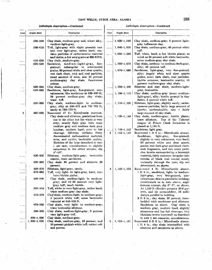
TEST WELLS, GUBIK AREA, ALASKA 233
Core -
----
- - - -
- - - - - - - -
- - - - - - - -
- - - -
2
- - - -
- - - -
- - - - - - - -
- - - - I - - - -
- - - -
7ritholoola dearniption-Continued I Lithologic descriptdon-Continued
Depth (feet) Desorlption I Core 1 Depth (feet) I Dewrlption I
- I
--
Clay shale, medium-gray and, where silty, medium-lightgray. .
Tuff, light-gray with slight greenish cast and very light-gray, rather hard; con- tains particles of carbonaceous material and biotite; a few sand grains a t 600-610 ft.
Clay shale, medium-gray. Sandstone, medium-light-gray, fine-
grained; subangular to subrounded grains, 80 percent white and clear quartz; rest dark chert, rock and coal particles, small smount of mica, also 15 percent medium-gray clay shale, Inoceramus prisms.
Clay shale, medium-gray. Sandstone, light-gray, fine-grained. non-
calcareous; like sandstone a t 620-630 ft ; 20 percent medium-gray clay shale; trace tuff.
Clay shale, medium-light- to medium- gray; silty a t 650-670 and 730-760 ft, sandy at 760-770 ft.
Recovered 17 f t : Microfossils common. Clay shale and siltstone, gradations from
one to the other but the whole is very silty; mostly light gray with some medium gray and medium dark gray laminae, medium hard; poor to fair cleavage. Siltstone contains finely disseminated carbonaceous material, mica, and pyrite; bentonitic matrix. Blotches of the type described in core 1 are rare; noncalcareous to slightly calcareous in the siltier streaks; dip 4O-10'.
Siltstone, medium-light-gray, bentonitic matrix, trace sandstone.
Clay shale 80 percent and siltstone 20 percent.
SilWne, light-gray, sandy. Tuff, very light- to light-gray, hard; con-
tains biotite plates. Clay shale, medium-light- to medium-
gray; and 10-30 percent very light- jgray tuff; much biotite.
Tug, white to very light-gray, rather hard; tliace medium-gray clay shale.
Clay shale, medium-light- to medium-gray; 5spercent white tuff; some bentonitic material a t 940-950 ft.
Clay shale, very light- to medium-gray; trace bentonitic siltstone.
Clay shale, medium-light-gray; 5 percent very light-gray tuff.
Clay shale, medium-gray. Clay shale, medium-gray, 50 percent, and
50 percent pinkish-white tuff; rather soft and porous.
Clay shale, medium-gray; 5 percent light- gray tuffaceous clay.
Clay shale, medium-gray; 40 percent white tuff.
Tuff, white, hard; a few biotite plates; as much as 60 percent soft white bentonite; some medium-gray clay shale.
Clay shale, medium- to medium-dark-gray, silty; 10 percent tuff.
Sandstone, light-gray, very fine-grained, silty; largely white and clear quartz grains, some dark chert, coal particles; biotite common; bentonitic matrix; 15 percent medium-gray clay shale.
Siltstone and clay shale, medium-light- gray, bentonitic.
Clay shale, medium-gray (some medium- light-gray), silty; biotite present in tiny flakes; 5 percent white tuff.
Siltstone, light-gray, slightly sandy; carbo- naceous psrticles; fairly large amount of biotite; nonbentonitic; also a fairly large amount of clay share.
Clay shale, medium-gray; biotite plates; trace siltstone. Top of the Tuluvak tongue of Prince Creek formation is placed a t 1,135 ft.
Sandstone, light gray. Recovered 1 ft 6 in.: Microfossils absent.
Sandstone, light-gray, fine-grained, slightly to very calcareous, very hard; 80 percent white and clear quartz grains; rest dark-gray and black chert, rock fragments, and rare coaly parti- cles; biotite surrounded by a brownish material, fairly common; irregular thin streaks of black coal extend nearly vertically through the core; dip not determined; no shows.
Recovered 4 ft: Microfossils absent. 1 f t 9 in., sandstone, light- to medium-
light-gray, very fine-grained, non- calcareous; cleaves parallel to bedding; constituents as in core above; argil- laceous cement; dip 5'-9'; no shows. At 1,150 ft effective porosity 20.6 per- cent, and air permeability, 18 milli- darcys parallel to bedding.
2 f t 3 in., clay shale, 50 percent, inter- bedded with sandstone and siltstone. Sandstone as above. Clay shale i~ medium gray, medium hard, slightly micaceous and has fair cleavage; tiny blotches (worm burrows?) as described in core 1 are common; noncalcareous.
Recovered 6 f t 6 in.: Microfossils absent. 1 f t 4 in., clay shale interbedded with
siltstone and sandstone as above.
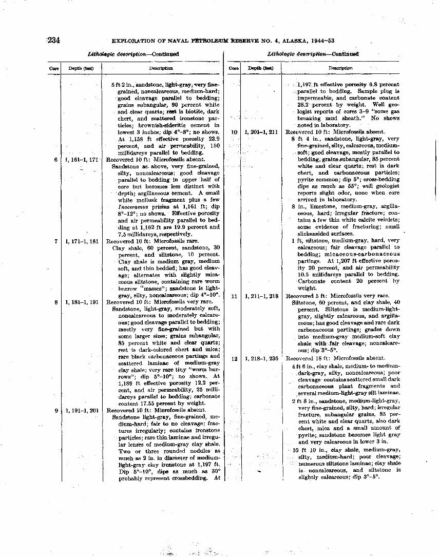
i234 EXPLORATION OF NATAL PETROLEUM RESERVE NO. 4, ALASKA, 1944-53
aleeortptiollcContinned
Deacriptlon
5 f t 2 in., sandstone, Wht-gray, very 6ne- grained, noncalcareous, medium-hard; g o d cleavage parallel to bedding; grains subangular, 90 percent white and clear quartz; rest is biotite, dark chert, and scattered ironstone par- ticles; brownish-sideritic cement in lowest 3 inches; dip 4'-8'; no shows. At 1,158 ft effective porosity 23.9 percent, and air permeability, 150 millidarcys parallel to bedding.
Recovered 10 ft: Microfossils absent. Sandstone as. above, very fine-grained,
silty, noncalcareous; good cleavage parallel to bedding in upper half of core but becomes less distinct with depth; argillaceous cement. A small white mollusk fragment plus a few Inoceramus prisms a t 1,161 f t ; dip 8"-12"; no shows. Effective porosity and air permeability parallel t o bed- ding a t 1,162 ft are 19.9 percent and 7.5 millidarcys, respectively.
Recovered 10 f t : Microfossils rare. Clay shale, 60 percent, sandstone, 30
percent, and siltstone, 10 percent. Clay shale is medium gray, medium soft, and thin bedded; has good cleav- age; alternates with slightly mica- ceous siltstone, containing rare worm burrow "masses" ; sandstone is light- gray, silty, n o n c a l m u s ; dip 40-100-
Recovered 10 ft: Microfossils very rare. Sandstone, light-gray, moderately soft,
noncdcareous to moderately calcare- ous; good cleavage parallel to bedding; mostly very finegrained but with some larger sizes; grains subangular, 85 percent white and clear quertz; rest is dark-colored chert and mica; rare partings and scattered laminae of medium-gmy clay shale; very rare tiny "worm bur- rows"; dip 5"-lo0; no shows. At 1,189 ft effective porosity 12.2 per- cent, and air permeability, 25 milli- darcys parallel to bedding; carbonate content 17.55 percent by weight.
Reeovered 10 f t : Microfossils absent. Sandstone light-gray, fine-grained, me-
dium-hard; fair to no cleavage; frac- tures irregularly; contains ironetone particles; rare thin laminae and irregu- lar lenses of medium-gray clay shale. Two or three rounded nodules as much as 2 in. in diameter of medium- light-gray day iroastone a t 1,197 ft. Dip 5°-100, dips as much as 30" probably represent crossbedding. At
core -
6
7
8
9
deacr#ptitm-Gontinn
Description
1,197 f t effective poroa&y 6.8 percent parallel to bedding. Sample plug is impermeable, and carbonate content 28.2 percent by weight. Well geo- logist reports of cores 3-9 "some gas breaking mud sheath." No shows noted in laboratory.
Reeovered 10 ft: Microfossils absent. 8 ft 4 in., eandstone, light-gray, very
fine-grained, silty, calcareous, medium- soft; good cleavage, mostly parallel t o bedding; grains subangular, 85 percent white and clear quartz; rest is dark chert, and carbonaceous particles; pyrite common; dip so; cross-bedding dips as much as 55"; well geologist reports siight odor, none when core arrived in laboratory.
8 in., limestone, medium-gray, argilla- ceous, hard; irregular fracture; con- tains a few thin white calcite veinlets; some evidence of fracturing; small slickensided surfaces.
1 ft, siltstone, medium-gray, hard, very calcareous; fair cleavage parallel t o bedding; micaceous-carbonaceous partings. At 1,207 f t effective poros- ity 20 percent, and air permeability 10.5 millidarcys parallel to bedding. Carbonate content 20 percent by weight.
Recovered 5 ft: Microfossils very rare. Siltstone, 60 percent, and clay shale, 40
percent. Siltstone is medium-light- gray, slightly calcareous, and argilla- ceous; has good cleavage and rare dark carbonaceous partings; grades down into medium-gray medium-soft clay shale with fair cleavage; noncalcare- ous; dip 3'-5'.
Recovered 18 ft: Microfossils absent. 4 f t 6 in., clay shale, medium- to medium-
dark-gray, silty, noncalcareous; poor cleavage contains scattered small dark carbonaceous plant fragments and several medium-light-gray silt laminae.
2 ft 8 in., sandstone, medium-light-gray, very fine-grained, silty, hard; irregular fracture, subangular gains, 85 per- cent white and clear quartz, also dark chert, mica and a small amount of pyrite; sandstone beoomes light gray and very calcareous in lower 3 in.
10 f t 10 in., d a y shale, medium-gray, silty, medillm-hard; poor cleavage; numerous siltstone laminae; clay shale is noncalcareous, and siltstone is slightly calcareous; dip 3"-5".
Cam -
10
11
12
.
U t h b g i c
Depth (feet)
1, 161-1, 171 - .
1,171-1, 181
1,181-1, 191
1 191-1, 201
Uthozegiu
Depth(B8eo
1, 202-1,211
1, 211-1,218
1, 218-1, 236
-
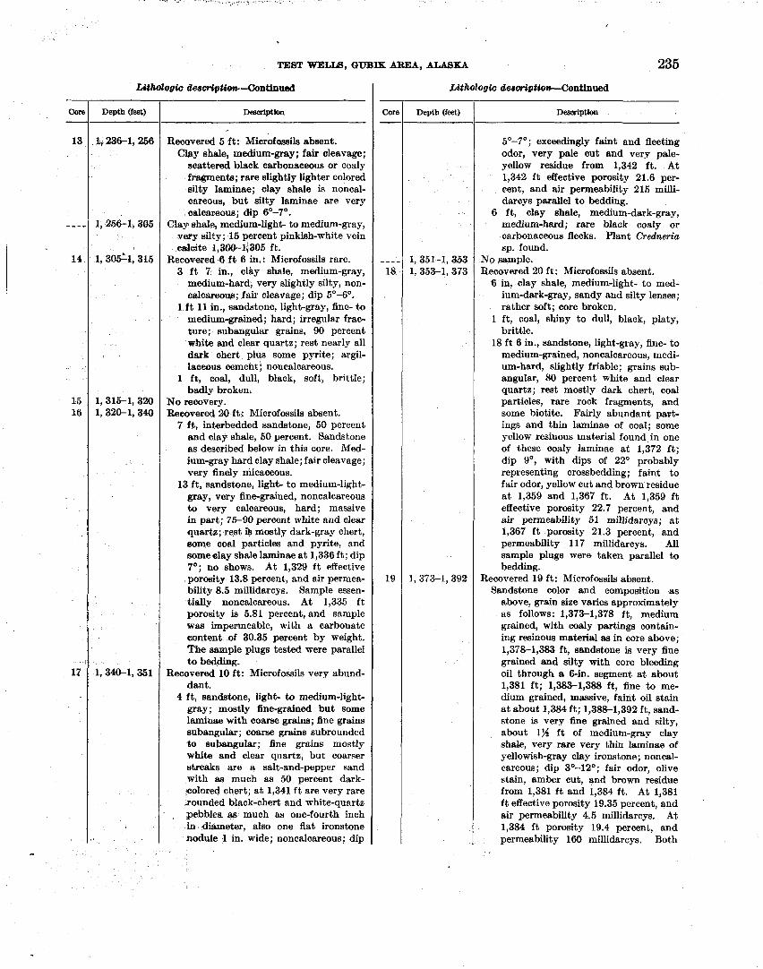
TEST WELLS, GWIK AREA, AUSKA 235
Core - 13
- - - -
14
15 16
l Z
Core
-- - - 18
19
Depth (feet)
I, 236-1, 256
1,256-1,305
1, 3051-1, 315
1,315-1,320 1,320-1, 340
1.340-1.351
L( (hd0gh &e8OriptiQ4l-~lltinUtd
D d p t i o n
Recovered 5 ft: Miorofasails absent. Clay shale, medium-gray; fair cleavage;
soattered black carbonaceous or coaly fragments; rare slightly lighter colored silty laminae; clay shale is noncal- eareous, but silty laminae are very oalcareous; dip 6O-7'.
Clay shale, medium-light- to medium-gray, very silty; 15 percent pinkish-white vein ealoite 1,300-13305 ft.
Recovered 6 f t 6 in.: Microfossils rare. 3 f t 7 in., clay shale, medium-gray,
medium-hard, very slightly silty, non- ealcareoug; fair cleavage; dip 5'-6'.
1 f t 11 in., sandstone, light-gray, fine- to medium-grained; hard; irregular frac- ture; subangular grains, 90 percent wbite and clear quartz; rest nearly all dark chert plus some pyrite; argil- laceous cement; noncalcareous.
1 ft, coal, dull, black, soft, brittle; badly broken.
No recovery. Recovered 20 f t : Microfossils absent.
7 ff, interbedded sandstone, 50 percent and clay shale, 50 percent. Sandstone as described below in this core. Med- ium-gray hard clay shale; fair cleavage; very finely micaceous.
13 ft, sandstone, light- to medium-light- gray, very fine-grained, noncalcareous to very calcareous, hard; massive in part; 75-90 percent white and clear quartz; rest is mostly dark-gray chert, some coal particles and pyrite, and some clay shale laminae a t 1,336 f t ; dip 7'; no shows. At 1,329 f t effective porosity 13.8 percent, and air permea- bility 8.5 millidarcys. Sample essen- tially noncalcareous. At 1,335 f t porosity is 5.81 percent, and sample was impermeable, with a carbonate eontent of 30.35 percent by weight. The sample plugs tested were parallel t o bedding.
Recovered 10 f t : Microfossils very abund- dant.
4 ft, sandstone, light- to medium-light- gray; mostly fine-gained but some laminae with coarse grains; fine grains subangular; coarse grains subrounded to subangular; fine grains mostly white and clear quartz, but coarser streaks are a salt-and-pepper sand with as much as 50 percent dark- colored chert; a t 1,341 f t are very rare ..rounded black-chert and white-quartz pebbles as much as one-fourth inch in diameter, also one flat ironstone nodule 1 in. wide; noncalcareous; dip
Depth (feet) --
1,351-1,353 1, 353-1,373
1,373-1,392
UthoZogi~ desoriptiow--Continued
Description
5'-7'; exceedingly faint and fleeting odor, very pale cut and very pale- yellow residue from 1,342 ft. At 1,342 f t effective porosity 21.6 per- cent, and air permeability 215 milli- darcys parallel to bedding.
6 ft, clay shale, medium-dark-gray, medium-hard; rare black coaly or carbonaceous flecks. Plant Credneria sp. found.
No sample. Recovered 20 ft: Microfossils absent.
6 in, clay shale, medium-light- to med- ium-dark-gray, sandy and silty lenses; rather soft; core broken.
1 f t , coal, shiny to dull, black, platy, brittle.
18 f t 6 in., sandstone, light-gray, fine- to medium-grained, noncalcareous, medi- um-hard, slightly friable; grains sub- angular, 80 percent white and clear quartz; rest mostly dark chert, coal particles, rare rock fragments, and some biotite. Fairly abundant part- ings and thin laminae of coal; some yellow resinous material found in one of these coaly laminae at 1,372 ft; dip go, with dips of 22O probably representing crossbedding; faint to fair odor, yellow cut and brown residue a t 1,359 and 1,367 ft. At 1,359 f t effective porosity 22.7 percent, and air permeability 51 millidarcys; a t 1,367 f t porosity 21.3 percent, and permeability 117 millidarcys. All sample plugs were taken parallel to bedding.
Recovered 19 ft: Microfossils absent. Sandstone color and composition as
above, grain size varies approximately as follows: 1,373-1,378 ft, medium grained, with coaly partings contain- ing resinous material as in core above; 1,37&1,383 ft, sandstone is very fine grained and silty with core bleeding oil through a 6-in. segment a t about 1,381 f t ; 1,383-1,388 ft, fine to me- dium grained, massive, faint oil stain a t about 1,384 ft; 1,38&1,392 ft, sand- stone is very fine grained and silty, about 1% f t of medium-gray clay shale, very rare very thin laminae of yellowish-gray clay ironstone; noncal- careous; dip 3'-12'; fair odor, olive stain, amber cut, and brown residue from 1,381 f t and 1,384 f t . At 1,381 f t effective porosity 19.35 percent, and air permeability 4.5 millidarcys. At 1,384 ft porosity 19.4 percent, and permeability 160 millidarcys. Both
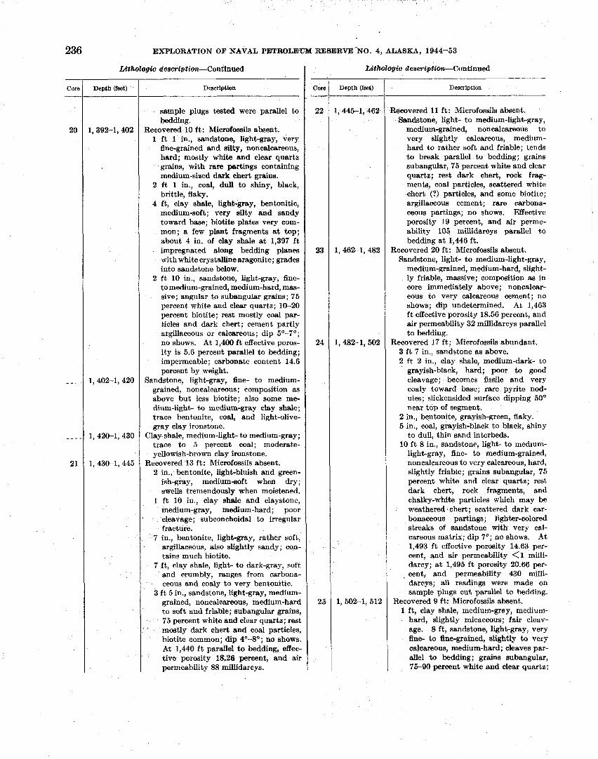
236 EXPLORATION OF NAVAL PBTRCTLEUM RESERVE-NO. 4, ALASKA, 1944-53
- Core Depth (feet) I Description
to soft and friable; subangular grains, 75 percent white and dear quartz; rest mostly dark chert and coal particles, biotite common; dip 4'4'; no shows. At 1,440 f t parallel to bedding, effec- tive porosity 18.26 percent, and air permeability 88 millidarcys.
sample plugs tested were parallel to bedding.
Recovered 10 ft : Microfossils absent. 1 ft 1 in., sandstone, light-gray, very
fine-grained and silty, noncalcareous, hard; mostly white and clear quartz grains, with rare partings containing medium-sized dark chert grains.
2 ft 1 in., coal, dull to shiny, black, brittle, flaky.
4 ft, clay shale, light-gray, bentonitic, medium-soft; very silty and sandy toward base; biotite plates very com- mon; a few plant fragments a t top; about 4 in. of clay shale a t 1,397 f t impregnated along bedding planes with white crystallinearagonite; grades into sandstone below.
2 ft 10 in., sandstone, light-gray, fine- to medium-grained, medium-hard, mas- sive; angular to subangular grains; 75 percent white and clear quartz; 10-20 percent biotite; rest mostly coal par- ticles and dark chert; cement partly argillaceous or calcareous; dip 5'-7'; no shows. At 1,400 ft effective poros- ity is 5.6 percent parallel to bedding; impermeable; carbonate content 14.6 percent by weight.
Sandstone, light-gray, fine- to medium- grained, noncalcareous; composition as above but less biotite; also some me- dium-light- to medium-gray clay shale; trace bentonite, coal, and light-olive- gray clay ironstone.
Clay shale, medium-light- to medium-gray; trace to 5 percent coal; moderate- yellowish-brown clay ironstone.
Recovered 13 ft: Microfossils absent. 2 in., bentonite, light-bluish and green-
ish-gray, medium-soft when dry; swells tremendously when moistened.
1 ft 10 in., clay shale and claystone, medium-gray, medium-hard; poor cleavage; subconchoidal to irregular fracture.
7 in., bentonite, light-gray, rather soft, argillaceous, also slightly sandy; con- tains much biotite.
7 ft, clay shale, light- to dark-gray, soft and crumbly, ranges from carbona- ceous and coaly to very bentonitic.
3 f t 5 in., sandstone, light-gray, medium- grained, noncalcareous, medium-hard
- Core
22
23
24
25
Depth (feet) Description
Recovered I1 ft : Microfossils absent. Sandstone, light- to medium-light-gray,
medium-grained, noncalcareous to very slightly calcareous, medium- hard to rather soft and friable; tends to break parallel to bedding; grains subangular, 75 percent white and clear quartz; rest dark chert, rock frag- ments, coal particles, scattered white chert (1) particles, and some biotite; argillaceous cement; rare carbona- ceous partings; no shows. Effective porosity 19 percent, and air perme- ability 105 millidaroys parallel to bedding a t 1,446 ft.
Recovered 20 ft: Microfossils absent. Sandstone, light- to medium-light-gray,
medium-grained, medium-hard, slight- ly friable, massive; composition as in core immediately above; noncalcar- eous to very calcareous cement; no shows; dip undetermined. At 1,463 ft effective porosity 18.56 percent, and air permeability 32 millidarcys parallel to bedding.
Recovered 17 ft; Microfossils abundant. 3 ft 7 in., sandstone as above. 2 ft 2 in., clay shale, medium-dark- to
grayish-black, hard; poor to good cleavage; becomes fissile and very coaly toward base; rare pyrite nod- ules; slickensided surface dipping 50' near top of segment.
2 in., bentonite, grayish-green, flaky. 5 in., coal, grayish-black to black, shiny
to dull, thin sand interbeds. 10 ft 8 in., sandstone, light- to medium-
light-gray, fine- to medium-grained, noncalcareous to very calcareous, hard, slightly friable; grains subangular, 75 percent white and clear quartz; rest dark chert, rock fragments, and chalky-whlk particles which may be weathered chert; scattered dark car- bonaceous partings; lighter-colored streaks of sandstone with very cal- careous matrix; dip 7'; no shows. A t 1,493 f t effective porosity 14.63 per- cent, and air permeability <1 milli- darcy; a t 1,495 f t porosity 20.66 per- cent, and permeability 430 milli- darcys; all readings were made on sample plugs cut parallel to bedding.
Recovered 9 ft: Microfossils absent. 1 f t , clay shale, medium-gray, medium-
hard, slightly micaceous; fair cleav- age. 8 ft, sandstone, light-gray, very fine- to fine-grained, slightly to very calcareous, medium-hard; cleaves par- allel to bedding; grains subangular, 75-90 percent white and clear quartz;
TEST WELLS, GUBIK AREA, ALASKA 237
Depth (feet) --
1,612-1,522
1,522-1,532
1, 532-1,542
1,542-1,552
Description
rest dark chert, rock fragments, and some biotite; argillaceous and cal- careous cement; dark carbonaceous partings common; rare clay shale laminae; dip 3'-7'; no shows. At
' 1,508 f t effective porosity is 8.65 per- cent; sample was impermeable; car- bonate content not tested. At 1,509 ft porosity 18.5 percent; sample un- suitable for permeability test, carbon- ate content 22.65 percent by weight.
Recovered 10 ft ; Microfossils absent. Interbedded clay shale, 40 percent,
siltstone, 30 percent, and sandstone, 30 percent. Clay shale is medium gray and medium hard; good cleav- age. Sandstone is medium light gray, very fine grained, medium soft and friable; good cleavage parallel to bed- ding; vertical fracture; 85 percent white and clear quartz grains, some with yellowish tinge; rest is dark chert, coal, rock particles, and mica; grades into siltstone; rare carbona- ceous partings, suggestion of swirly bedding a t 1,513 f t , very rare dark plant impressions near top; noncal- careous; dip 4'-7O; no shows. Effec- tive porosity 21.62 percent, and air permeability, 43.5 millidarcys (sample cracked) parallel to bedding.
Recovered 5 f t : Microfossils absent. Interbedded clay shale, 80 percent and
siltstone, 20 percent. Clay shale is medium gray, medium hard, and slightly micaceous; fair cleavage. Siltstone is medium light gray and medium hard; has fair cleavage; grades from clay to silt; very thin laminae of shiny black coal a t bottom of core; very slightly sideritic streaks; no shows.
Recovered 1 f t 6 in.: Microfossils absent. Biltstone, light-gray, sandy, noncal-
careous, soft to hard; bentonite in streaks; fair cieavage; also laminae of soft medium-gray clay shale and light- bluish-gray bentonite; dip undeter- mined; no shows.
Recovered 8 f t : Microfossils absent. Sandstone, medium-light-gray, very fine-
grained, silty, medium-soft and friable to medium-hard; tends to cleave parallel to bedding; vertical fracture; grains subangular, 80 percent white and clear quartz; rest coal particles, rock fragments, and common chert and mica; slightly bentonitic partings at 1,544 ft, light-olive-gray flat iron- stone nodules as much as 135 in. in
- Core
diameter a t 1,546-1, 547 ft; mostly noncalcareous but very calcareous a t 1,547 ft; dip 9'; no shows.
Recovered 2 f t : Microfossils absent. Sandstone, very fine-grained, silty (as
Depth (feet)
above), noncalcareous, micaceous, one- half in. medium-gray hard limestone a t bottom of core; dip 7-19'; no shows. At 1,553 f t , effective porosity 11.87
Description
percent parallel to bedding, and sample plug is impermeable.
Recovered 3 ft: Microfossils absent. 4 in., limestone, medium-gray, hard,
vertical fracture. 2 f t 8 in., sandstone, medium-light-gray,
very fine-grained and silty, noncalcar- eous, medium-hard; grains subangular, largely white and cleal quartz; good cleavage parallel to bedding; carbo- naceous-micaceous partings; dip 9'; no shows. A t 1,557 f t effective
- I
porosity 11.12 percent, and sample plug is impermeable.
Recovered 10 ft: Microfossils absent. Sandstone and siltstone, as in core 31
above, very fine-grained, noncalcare- ous, medium-hard; good to excellent cleavage; carbonaceous-micaceous partinm; yellowish-gray ironstone lam- inae m much as 2 in. thick a t 1,561 and 1,565 ft ; scattered medium-gray clay shale laminae; dip 4'-9'; no shows. At 1,560 ft effective porosity 16.71 percent, and air permeability 6.96 millidarcys parallel to bedding.
Recovered 10 ft: Microfossils absent. Interbedded siltstone, 80 percent and
clay shale, 20 percent. Siltstone is medium light gray, hard, slightly sandy, also argillaceous; tends to cleave parallel to bedding; grains almost entirely white and clear quartz; small amount of crossbedding. Clay shale is medium gray, noncalcareous, and moderately hard; fair cleavage; closely interbedded with the silt- stone; finely micaceous, exceedingly rare bentonitic partings; yellowish- gray ironstone nodules a t 1,570 f t and 1,577 ft; dip 6'; no shows. At 1,574 f t effective porosity 14.90 per- cent, and sample plug is impermeable.
Recovered 2 ft .: Microfossils common. Interbedded clay shale, 70 percent, and
30 percent finely micaceous siltstone; crossbedding on a small scale; 2 inches of yellowish ironstone in about the middle of the core; noncalcareous except for sideritic concretion; dip 6". At 1,580 f t effective porosity 12.15 percent and sample plug impermeable.
288 EXPLORATION OF NMAL PE!3!BDI*EUM RESEBVE NO, 4, ALASICA, 1944-53
Sandstone, light- to medium-light-gray, very fine-grained, silty.
Clay shale, medium-light-gray with some medium-gray, slightly to very silty; trace sandstone; trace bentonite and bentonitic greenish-gray shale; trace light-olive-gray ironstone.
Wltstone, light-gray, slightly sandy, ar- gillaceous, noncalcareous; biotite com- mon.
Clay shale, silty, and argillaceous siltstone; micaceous.
Clay shale, medium-light to medium- gray; trace bentonitic siltstone 1,645- 1,655 ft; tpace to 5 percent ironstone a t 1,660-1,669 ft; trace coal; dark-gray carbonaceous shale and bentonitic shale at 1,660-1,669 ft; trace to 5 percent white bentonite 1,665-1,670 ft.
Recovered 7 f t . Microfossils absent. Interbedded sandstone, 40 percent, silt-
stone, 30 percent, and clay shale, 30 percent. Sandstone is light to medium light gray, hard, medium grained; subangular grains 80 percent white and clear quartz grains; rest almost all dark-gray and black chert plus fairly abundant pyrite; grades into .medium-light-gray siltstone and medium-gray moderately hard finely micaceous clay shale with good cleavage; siltstone and clay shale noncalcsreous; dip 6'; no shows. At 1,673 f t effective porosity 15.7 per- cent; sample unsuitable for permea- bility test.
Recovered 4 ft 6 in.: Microfwsils absent. Clay shale, 60 percent and siltstone, 40
percent, very closely interbedded in thin varvelike beds. Siltstone is medium light gray with sandy streaks. Clay shale is medium to medium dark gray and noncalcareous; an inch of dark-gray argillaceous coal 6 in. from top of core; one piece of clear yellow resinous material embedded in shale near coal; carbonaceous and micaceous partings; dip 3O-7O.
No recovery. No recovery. A few chunks of wre taken
from bit a t 1,700 f t consisted of hard medium-gray siltstone laced wlth b l a ~ k coaly plant imprembns; also m e medium-gray clay shale.
Raaovered 6 ft: Microfossils absent. Sandstone, light-gray, salt-and-pepper, fine- to medium-grained (mostly the l a t h ) , also rare coarse grains; hard, massive; angular to subangular grains, 65 percent white and clear quartz, 20
I Description .
percent dark-gray and black chert, also some opaque white material (weathered chert or possibly feldspar) some yellow quartz, rare brown iron- stone particles, some mica; calcareous cement; one medium-dark-gray sub- rounded chert pebble one-half inch in diameter a t 1,704 ft. Dip unde- termined. Very faint odor, straw- colored cut and pale-yellow residue from 1,702 ft. At 1,702 f t effective porosity parallel to bedding 16.61 percent, and air -permeability 13 millidarcys; oarbonate content 17.55 percent by weight.
1, 706-1, 722 Recovered 16 ft: Microfossils absent. Sandstone, composition as above, me-
dium-grained with scattered coarse- grained streaks; grain size decreases to fine toward base of core. On parting of clay shale and one of coal near top of core; light-colored very calcareous cement in upper 2 ft; rest of core noncalcareous; dip 5O; very faint odor, pale-straw-colored cut and pale-yellow residue a t 1,710 ft. The
I following porosity and permeability determinations were made:
0 1 - - 14.65 9.5 Trace. 1,7l5 W e 1 ------------ Do. 1,719,~ ';:hi 1 DO.
Air Effec- perrnes-
&pth (feet) tive po- bility rosity (milli-
(percant) darcys)
- ---- ---- - ----
41 1,7221,731 Recovered 8 ft: Microfossils absent: Sandstone, medium-light-gray, very fine-
grained, hard; cleaves parallel to bed- ding; grains subangular, 85 percent white and clear quartz; rest rock frag-
1 ments, dark chert, carbonaceous parti- cles, and common biotite; argillaceous cement. About 10 percent of the re- covery is medium-gray hard finely mi-
Carbon- ate con-
tent (percent
by weight) - -
caceous clay shale, with fair cleavage; noncalcareous to slightly calcareous in upper few feet of core where there is some sideritic cement; dip 4'; no ahows. At 1,726 f t effective porosity 7.62 percent; sample plug is imper- meable, and carbonate content 28.4 percent by weight.
737 Recoxere4 3 f t 6 in.: Microfossils common. Interbedded siltstone, 60 percent, and
clay shale,. 40 Nrcent. Siltstone is medium light gray, hard; interbedded with and gradational with medium-
TE6T WELLS, GUBIK AREA, ALASKA * . 239
- -- -
----
- - - -
- - - -
- - - -
----
- - - -
43 44
Description
rare clay shale laminae; drop test indi- a cates moderate porosity; dip go; no
shows. ''Recovered 6 ft: Microfossils absent.
Sandstone, light-gray, clean, coarse- ' grained, soft to nearly unconsolidated;
friable although upper 2 f t of recovery was hard; cleaves approximately paral- lel t o bedding; subangular, salt-and-
I . pepper sandstone, 50 percent white and clear quarta grains, 45 percent. dark-gray and brown chert, rock frag- ments, and ooaly particles; mica and other minerals rare; loosely cemented with argillaceous material and in some places with calcite. Rare car- bonaceous partings in upper foot of recovery; very calcareous in upper 2 f t and noncalcareous below; dip 10'; no shows.
Recovered 6 ft 6 in.: Microfossils absent. Sandstone, color and composition as
above, soft, coarse, rarely very coarse, noncalcareous; dip undetermined.
Recovered 4 ft.: Microfossils absent. Sandstone, color and composition as
above, nearly unconsolidated, coarse- to very coarse-grained, noncalcareous; 55 percent dark minerals and rock fragments, 45 percent light-colored quartz; dip undetermined; no shows.
Recovered 7 ft: Microfoasils absent. Sandstone, light-gray, coarse- to very
coarse-grained, noncalcareous, salt- and-pepper, soft, friable, clean, poker- chip cleavage; subangular to sub- rounded grains, 55 percent dark-gray, brown, and black chert, dark-colored rock fragments and coaly particles, 45 percent white and clear quartz, very rare rounded black chert granules and pebbles; also brown flat pebbles or nod- ules of clay ironstone as much as 2 in. in diameter particularly a t 1,847 ft; one 2-in. medium-gray clay shale peb- ble a t 1,845 f t ; argillaceous cement; dip go; faint odor, straw-colored cut, yel- low residue from 1,843 ft; faint odor, pale-straw-colored cut, and yellow residue from 1,846 ft. At 1,843 f t ef- fective porosity 25.2 percent, and air permeability 3,780 millidarcys parallel to bedding.
Recovered 20 ft: Microfossils absent. Sandstone as above, but slightly more . consolidated; cleavage not developed
quite as well; brown ironstone nodnbs as much as 1-in. thick a t 1,848, 1,849,
. 1,850, 1,858, 1,861, 1,862, and 1,865 ft. Black carbonaceous plant frag-
Core
45
47
48
49
I .
1,737-f, 745 a s s .
1, 745-1,750
1,750-1, 765 *,
1,565-1, 770
1,771Y-1,780
1, 780-1, 795
1, 795-1, 806
1,806-1,813 1,813-1,820
Depth (feet)
1, 820-1,826
1, 82&1,836
1, 836-1,841
1, 841-1,848
1,84&1,868
:gay hard finely micaceous clay shale with ftridy good cleavage; noncalcar- eoub; dip .so; no shows. At 1,730 f t effective porosity 4.89 percent, and sample plug impermeable.
,'C!lby shale, 60 percent, medium-light-gray; . %O' Hfcent light-gray siltstone; and 10
pertmrt llght-gray medium-grained sand- stone; %race very light-gray bentonitic clay e W ; coal and ironstbne.
SancZatond; light-gray, very fine-grained, noncalcsreous, hard; subrounded to sub- Angular grains, 85 percent white and dear qbartz, also black carbonaceous h s i g ~ n t s , dark chert, and mica; 5 per- cent meaium-gray clay shale.
Bentonite, ' white; also medium-dark-gray * clay shsle; tram grayish-black carbo-
naceous shale and coal; trace slightly cal- eareohs ve@ fine- to fine-grained sand- atone.
Clay shmrle, medium-light-gray ; trace sand- stone, bentonite, and coal.
Shhdstone, light-gray, medium-grained; vbangular to (rarely) subrounded &ains, d percent white and clear quartz; mt mo&ly dark-gray and black chert, some coal particles; trace clay shale and coal.
CI4y shale, medium-light-gray; trace car- b;onabeoUs shale, bentonite, and iron- Mane; 15 percent sandstone a t 1,790- 1,795 ft .
Sandstone, light-gray, salt-and-pepper, very She- to very coarse-grained, non- calcareous, s 6 t ; 65 percent white and clear quartz, 30 percent dark-gray and black chert, some coal particles and mica, rare rounded black chert granules; trace to 10 percent medium-light-gray clay shale; 10 percent shiny black coal a t 1,800-1,805 ft; trace very light-gray bentonitic clay shale a t 1,805-1,810 ft.
No recovery. Recovered 7 ft : Microfossils absent.
1 ft 6 in., interbedded siltstone, 90 per- cent, and clay shale; medium-light- gray and medium-gray, noncalcareous, hard, sandy, with fair cleavage; dip go.
5 f t 6 in., sandstone, light-gray, medium- to coarse-grained, noncalcareous, me- dium-hard but slightly friable; good, nearly poker-ohip cleavage; grains sub- angular; salt-and-pepper sandstone; 55 percent white and clear quartz grains, 40 percent rock fragments and dark- gray, brownish, and black chert; other minerals rare; argillaceous ce- ment; numerous coaly partings; quite coaly in the lowest 6 in. of recovery;
240 EXPLORATION OF NAVAL PEwLETJhf RESE@VE NO. 4, ALASKA, 1944-53
Con -
Depth (feet) Description - menta and black coaly laminae at! 1,865, 1,861, and 1,864 ft; clear yellow resinous material in the coal; very ca1care;ous in upper, foot of core and rarely in other spots, noncalcareous elsewhere; dip 8'; faint odor, pale- straw-colored cut, yellow residue from 1,852 ft; faint odor, pale-yellow cut, brownish-yellow residue from 1,856 ft; faint odor, yellow cut and yellow-
. brown residue from 1,861 and 1,865 f t . Following porosity and permeability determinations were made.
Effec- Air
Recovered 12 ft: Microfossils absent. 5 f t 6 in., sandstone, lighbgray, medium-
to (rare) coarse-grained, medium-soft; cleaves parallel to bedding; subangular greins, 60 percent white and clear quartz; rest mostly brown and gray chert; other minerals rare; argillaceous cement except for 6 in. with light- colored very calcareous cement a t 1,873 ft; scattered dark carbonaceous partings; dip 9'; faint odor, yellow cut and yellowish-brown residue a t 1,872 ft. At 1,871 ft effective porosity 19.64 percent, and air permeability 270 millidarcys (plug cracked) ; essen- tially noncalcareoua. At 1,873 f t porosity 5.45 percent, and sample plug impermeable; carbonate content 24.8 percent by weight. Abrupt change to unit below.
5 f t , siltstone, medium-light-gray, me- dium-hard; excellent cleavage in part; much finely disseminated carbona- ceous material and scattered partings with black broken plant fragments; rare irregular sandy lenses; dip 4O-7O; grades into unit below.
1 f t 6 in., clay shale, medium-light-gray, noncalcareous, rather hard and brittle, thin-bedded; uniform in color and tex- ture; fair cleavage; s i n . layer of yellowish-gray clay ironstone and ?&in. layer light-gray soft bentonitic shale near base. .
Recovered 5 ft: Microfossils absent. Clay shale, medium-light- to medium-
gray, noncalcareoua, medium-soft to
Core 1 Depth (feet) I Description
medium-hard; poor to fair hackly cleavage; possibly slightly bentonitic; medium-light-gray siltstone laminae as much as 2 in. thick also present; dip 7O.
Clay shale, medium-light- to medium-gray ; trace siltstone and ironstone; also trace very calcareous 'medium- to coarse- grained sandstone aa below.
Sandstone, light-gray, salt-and-pepper, fine- to coarse-grained granule; grains suban- gular to subrounded; granules rounded; quartz and chert grains; very calcareous cement in part, loose sand grains in part; 10 percent medium-light-gray clay shale and 5 percent clay ironstone.
Clay shale, medium-light- to dark-gray. Recovered 20 ft: Microfossils absent.
2 ft, claystone, medium-dark-gray, non- . calcareous, hard, dense; hackly or no
cleavage; subconchoidal fracture; al- most vertical slickensides a t 1,916 ft; excellent small black leaf impressions throughout the core. These leaves identified by Roland W. Brown, U. S. Geological Survey, as TrapaP micro- phylla Lesquereux, which ranges in age from Late Cretaceous to Paleocene; grades down into unit below.
8 ft, interbedded siltstone, 70 percent, and very fine-grained sandstone; light- to medium-light-gray, hard, argilla- ceous; some small scale crossbedding; impression of large leaf a t 1,923 ft , shiny black coal fragments 2 in. long embedded in the sandstone at 1,924 ft; sandstone very slightly calcareous; dips variable, average about 7'; grades into unit below.
10 ft, sandstone, light-gray, medium- to (very rare) coarse-grained, medium- hard, massive; irregular fracture; sub- angular to subrounded grains, 50 per- cent white and clear quartz; rest is dark-gray, brown, and black chert, rock fragments, and scattered coaly particles; very rare ironstone nodules; dip undetermined; no odor, no cut, very pale-yellow residue from 1,932 ft.
Air Carbon- Effec- permea- ate con-
Depth (feet) tive po- billty tent rosity ( m u - (percent
(percent) darcys) by weight)
TEST WELLS, GUBIK AREA, ALASKA 241
core 1 ~ e p t h (feet) Description ----
.I, 955
53.8.
1,948 pamuel ------------ Do.
Recovered 20 ft: Microf~ssils absent. Sandstone color and composition as
above, grain size variable, very fine- to he-grained in the upper 6 ft; also numerous partings with broken black l e d impressions. Rest of core medium grained; no odor, no cut, greasy film in evaporating dish, from 1,948 ft.
Depth (feet)
-------A-
Recovered 5 ft: Microfossils absent. 4 ft, sandstone, light-gray, fine- to (rare)
coarse- ained, hard; irregular frac- ture; f ubangular grains; constituents as above but with 75 percent white and clear quartz; very rare silty lami- nae; noncdcareous to very calcareous in thin light-colored streaks; dips as much as 15' probably indicate cross- bedding; no shows. At 1,957 f t effec- tive porosity 16.8 percent, and air permeability 12.5 millidarcys parallel to bedding.
1 ft, coal, shiny to dull, black, blocky fracture, a few inches of carbonaceous mndstone a t base.
Recovered 20 ft: Microfossils absent. Sandstone, light-gray, hard, fine- to
medium-grained; massive in upper half of core, subangular to subrounded grains, 3-5 percent white and clear
Effec- tive po- rosity
(percent)
----
quartz, 20 percent dark-gray and black chert, dark-colored rock frag- ments, and coal particles; some dark carbonaceous coaly partings particu- larly in lower half of core, some clear resinous material with the coal; two small rounded black-chert pebbles (tbee-fourths inch in diameter) a t 1,972 ft. Six inches of paper-thin lam- inae of clay shale topping a t 1,973 f t , medium-light-greenish-gray, contains awndant black carbonaceous par- tides, also much biotite and large (ow-sixteenth inch) plates of white mha; matrix resembles bentonite but does not swell when moistened; non- cslioareous to very calcareous cement; dip 5'-7'; no shows. Porosity and
' ?
Air permea-
bility (milli-
darcys)
-----
Core / Depth (feat) I Description -
Carbon- ate con-
tent (percent
by weight)
permeability determina*iws were made as follows:
I Depth (feet)
8 Carbon- ate con-
tent (percent
by weight)
Effec- tive por-
Air permea- bility
some mica; rare thin laminae of light- gray clay shale; dip 3'; no shows.
Sandstone, light-gray, very fine-grained, soft, noncalcareous; 95 percent white
osity (rnilli- (percent) darcys)
1,980-1, 984
and clear quartz grains, rare dark chert and biotite.
1,995-2, W Clay shale, 70 percent, medium-light-gray, and sandstone as above.
2,000-2,030 Sandstone, light-gray, salt-and-pepper; fine- to medium-grained, 75 percent white and clear quartz grains; white, very calcareous matrix a t 2,020-2,030 ft . The top of the Seabee formation is placed a t 2,010 ft.
2, 030-2, 069 Clay shale, 50-80 percent, medium-light- gray and light-gray, fine- to medium-
Recovered 4 ft: Microfossils absent. '
grained sandstone; trace brownish-gray clay ironstone a t 2,050-2,060 ft.
2, 069-2, 079 Recovered 10 ft: Microfossils absent. 4 ft, claystone, medium-gray, hard,
dense; irregular fracture; finely dis-
Sandstone, light-gray, fine-grained, non- calcareous, hard; breaks parallel to bedding; some very fine-grained and silty layers; 85 percent white and clear quartz grains; rest is mostly dark chert, carbonaceous particles, and
seminated mica gives a sheen to the fracture surfaces.
6 ft, interbedded clay shale, 85 percent, and siltstone, 15 percent. Clay shale is medium gray; alternates with very thin beds of mediurn-light-gray hard siltstone, with good cleavage, and rare carbonaceous flecks: yellowish- gray ironstone concretions fair1 y com- mon; noncalcareous; dip 7'.
Recovered 10 ft: Microfossils rare. Interbedded clay shale as above, 65 per-
cent, and siltstone, as above, 35 per- cent, contacts between the two mostly quite sharp; small amount of grada- tion; rare carbonaceous partings; iron- stone lenses and laminae present; noncalcareous; dip 5'-7'.
242 EXPLORATION O F NAVAL PETROLEBE4 'RESERVE NO. 4, ALASKA, 1944-53
Cors
68
64
6b
66
87
----
---,
- -- - -,-,
- ,- -
- - - -
: - -.-
& - & p t i o ~ ~
Be=@-
Recoveed 20 f t : Microfossils common. 10 f t -6 in., interbedded siltstone, as
above, 75 percent and clay shale as above; 6 inches of light-gray medium- grained sandstone a t 2,090 ft; yellow- ish-gray ironstone nodule a t 2,093 ft; a few very small white pelecypods and gastropods a t 2,095 ft; some pyrite stringers; noncalcsreous; dip 5'-7O.
9 ft 6 in., sandstone, light-gray, f ine grained, hard, massive; subangular grains, 80 percent white and clear quartz, some with -yellowish tinge; rmkia d a ~ k chert, rock fragments, coal particles and mica; some calcareous cemeat; no shows. At 2,100 f t effec- tive porosity 11.32 percent, air per- meability 3.5 millidarcys and carbon- ate content 12.85 percent by weight. At 2,107 f t porosity 15.4 percent, per- meability 6.1 millidarcys, and carbon- ate content 16.51 percent.
Recovered 17 ft : Micmfossils absent. Srmdstone, light- to medium-gray, very
fine- to fine-grained, silty, hard to very hard ; irregular fracture; com- position as in core above; upper 6 f t of core ~xtrsmely calcareous, nearly a silty l i m w n e ; at 2,113 f t a 216-in.-thick white-calcite vein ex- tends a t an anglcof 70' through the core; one small poorly preserved pele- cypod a t 2,127 ft; dip 5'; no shows. At 2,110 f t dective porosity 0.76 per- cent, sample impermeable, and car- bonate content 49.6 percent by weight. At 2,125 ft porosity 15.2 percent, per- meability 4.5 millidarcys, and carbon- ate content 21.05 percent.
Recovered 16 f*: Microfossils rare. Siltstone and very fine-grained sand-
stone, light- to medium-light gray, medium-hard; excellent cleavage; nu- merous partings oontaining black car- bonaceous plant particles; 5-10 per- cent thin medium-gray laminae of clay shale; noncalcareous; dip 6'; no shows. At 2,132 f t effective porosity 11.39 percent, and a t 2,140 f t 7.3 per- cent. Both samples impermeable.
Recovered 1 ft: Midosai ls rare. Silktone with clay shale streaks as
above; dip 5'. Clay shale, 80 percent, medium-light-gray ;
and light-gray fine- to medium-grained sandstone.
Siltstone and very fine-grained sandstone, light- to medium-light-gray, noncal- careous; trace to 10 percent medium- light-gray clay shale.
Core -
,59 '
60
61
62
- - - -
- - - -
hh&i9@d
Depth (feet)
2, @3089i2, 109
2,109-2, 129
2, 129-2, 145
2, 145-2, 146
2, 146-2, 155
2,156-2,370
L€#?b&o$Co
Depth (feet)
2,170-2,180
2, 1'80-2, 190
2,190-2,200
2,200-2,210 - .
210-2,218
2,218-2,370
2,370-2,400
2,400-2,470
2,470-2, 510
.
2,5104,520
2,52Q.%, 680
. ,
2,6804,690
demript.tok-Oontfnned
Desaiption
R b c o v e a 7-! ft: Microfa~sils abundant. Interbeckkd siltatone, 60 percent, and
elay slabg 40 percent, medium-light- antf'mediuin-gray, noncalcareous, me- dium-hmd; excellent cleavage; mica- ceous-carbunaceous partings; dip 6'.
Recovered 9 ft: Microfossils very abun- dant.
Interbedded siltstone as above, 50 per- cent, and clay shale, as above, 50 per- cent; dip 5'.
Recovered 10 ft: Microfossils abundant. Clay shale, medium-dark-gray, medium-
hard, good cleavage; about 25 percent medium-light-gray thin siltstone lami- nae; carbonaceous and micaceous part- ings; fragment of unidentified dicot- yledonous leaf; noncalcareous; dip 6'.
Recovered 8 ft: Microfossils abundant. ~4 ft, day shale, medium-dark-gray, non-
oslemeous, hard; 5 percent silty lami- nae: qnetiny white mollusk fragment a t t q ~ o!core; poor to fair cleavage.
1 ft 3 in., limestone, medium-light- to medium-gay, hard, argillaceous; irreg- ular fracture.
2 f t 9 in., clay shale as in upper part of core; carbonaceous and micaceous partings; dip 6'.
Recovered 2 ft: Microfossils abundant. Clay.shale as immediately above.
Clay shale, medium-light- to medium- dsrk-gray, primarily medium-gray ; as much as 1Q percent medium-light-gray caleite a t 2,315-2,325 ft.
Clay shale, medium-light- t o medium- dark-gray, micaceous; trace siltstone.
Clay sWe, medium-light- to medium-gray ; trace siltstone a t 2,4262,460 ft.
Cfsy shale, medium-light- to medium-gray; trace to 5 .pe~cent siltstone, one-third is medium light to light gray at 2,490- 2,510 ft; 30 percent bentonitic light-gray shah 2,470-2,480 ft; trace of medium- light-gray limestone and aragonite at 2,470-2,480 ft; trace of bentonitic clay shale; and 6 percent very calcareous silt- stone a t 2,480-2,490 ft.
Si&stone, 90 percent, light-gray, slightly calcareous; and medium-gray clay shale.
Clay shale, medium-light- to medium-gray ; 10 percent shiny to dull black coal at 2,520-2,530 ft; 10 percent medium-light- gray sibstone; some medium-dark-gray shale; clump of znoceramua prisms a t 2,540-2,550 ft; pieces of Znoeesamus shell
- and fish fragments a t 2,670-2,680 ft. Silktone, medium-light-gray, argillaceous,
noncalcareoua, and medium-gray clay ahale; clump of Inouramus prisms.
, I , , ": TEST WELLS, G W I g AREA, ALABBIA 2k_3
- - -
Carel De~th(Ieet) 1 ~escription
3,04Q-3,100 .$ Clay shale, mediumdark-gray; trace to 15 percent very light-gray to white benton- ite or bentonitic shale; bentonite oontains brown biotite plates. Trace white aragonite st 3,09&3,095 ft; Inocetams prisms, fish fragments, and Radiolaria also present. This may be compared to the black fissile shale of Umiat area.
- - - -
---,
- - - -
- ,, -
----
+ - - -
----
- - --
----
-- , ,
, - -,
- - - -
- - - -
- - - -
2,690-2,700
2,700-2,760
2, 760-2, :7.7Q
2 , 7 7 0 4 784l.1
2,780-2,790
2,790-2,800
2,800-2,810
:
2,8115-2,840
2,840-2,870
2,870-2,
2,900-2,. Q@
2,930-5940
a
2,940-2,990
2,9504,040
I v., .
3, 100-3, 110
Recovered 6 ft: Microfossils absent. 5 f t 6 in., very fine-grained sandstone, as
above, and siltstone; a few inches of medium-light-gray clay shale a t 3,120 ft. Clay shale c o h i n e very light- g a y silty sfightly bentonitic partings; dip undetermined, probably low: Ifion- calcareous; no shows.
6 in., limestone, medium-gray, silty, argillaceous, medium-hard,
Clay shale, medium-light- to medium- dark-gay, silty; trace bentonite.
Clay We, medium- to medium-dark-gray ; one piece of Znmeramus shell; trace silt- s tme sgd trace light-gray bentonite con- t d i n g biotite phtea.
Clay shale, medium-light- to medium-gray, silty; trace coal a t 2,740-2,750 ft; chunks of Inmeramue prisms a t 2,700- 2,710 m d 2,740-2,750 ft; some medium- dmk-gsay clay shale and fish fragments at.2,750-2,760 ft.
Clay &ale, medium-light-gray ; trace light- gmy b t o n i t i c clay shale; trace coal, Z ~ ~ ~ + % ~ W V U B chunks.
Clay shale, medium-gray ; trace brownish- gray limeatone.
Clay shade, medium-gray; trace white bentoaib and shiny black coal; Ino- cssams,chunk.
Clay shale, medium-gray ; some medium- lightgray siltstone; slightly calcareous; trrrae medium-dark-gray limestone; small cr&ite vein; trace white bentonite; Iwceramue chunks.
Silt$Bgne, 78 w e n t , medium-light- to mediumgrfr3r, very calcareous; medium- dark-gray limestone and clay shale as much aa 30 percent; trace very light- gray bentonitic clay shale and white bentaaite; trace shiny black coal.
Clay ahale, medium-gray, silty ; trace white aragonite a sd bentonitic clay; Ino- eersms prisms a t 2,810-2,820 ft .
Clay shale, medipm-gray, and as much as 30 percent mediltm-light-gray siltstone; trace mdtatone a t 2,86@-2,870 ft.
Clay shale, medium- to medium-dark-gray ; trme cod; trace very light- and green- ish-gray 4ay shale; trace limestone and white calcite crystals a t 2,890-2,900 ft; I m t o m u s chuwks. i t
Clay shale, medium- to medium-dark- grgy; trace coal a t 2,900-2,920 ft; trace very fine-grained sandstone a t 2,910- 2,920 ft., contains biotite.
Sandstone, light- to medium-light-gray, soft, very fine- to (rarely) medium- grained; 85 percent white and clear q w t r meins; rest dark-colored chert, roek fragments, and some biotite; harder chips of sandstone very slightly caloamus; trace medium-gray clay s w .
, Clay shale, medium-gray ; 30 percent sand- staae ae above.
Clay shnle, l ight to medium-dark-gray, mastly medium-gray; trace siltstone a t 2,988-2,985 &t and 3,010-3,020 ft; Ino- emmw :pxisms a t 2,970-2,975 f t and s*wh%.990 ft. ~ ' .
Recovered 10 ft: Microfossils abundant. 4 f t 6 in., clay shale, medium-dark-gray,
moderately hard; f& cleavage; biotite common; 2 in. light-gray bentonitic shale a t 3,102 f t and 1 in. a t 3,104 ft. Shale includes much white aragonite extending 5 in. along the bedding planes and terminating upward a t 3,1023 ft; also a few thin vertical veins of aragonite. Clay shale grades into unit below.
5 f t 6 in., sandstone, light-gray, very , fine-grained (grading to siltstone),
slightly to moderatel-y 'cahareous, massive, hard; irregular fracture; grains subangular, 75 percent white and clear quarts; rest 3s rock fragments, dark chert, biotite, and carbonaceous particles; dip undetermined; no shows in laboratory, but well geologist re- ported eore bled slight amount of gas. At 3,106ft effective porosity 11.31 per-
3, 110-3, I20
60 percent, medium-light-gay, argillaceous, and medium-gray clay
oent, sample plug impermeable, and carbonate content 8.63 percent by weight.
Recovered 10 ft: Microfossils absent. Sandst'one; very silty, noncalcareous to
' . slightly calcareous; 90 percent white Itnd clear quarts; dips as high as 15O probably indicate crossbedding; reg- ular 'dip about 4O (?); no shows. A t 3,112 f t effective porosity 10.6 per- cent, sample impermeable, and car- bonate content 9.79 percent by weight.
4%tf4 EXPLORATION OF NAVAL PE'PBOLEW IUWERVE NO. 4, ALASKA, 1944-53
Clay shale, medium- to medium-dark- g a y , silty; trace to 15 percent bluish- gray bentonite; trace aragonite; chunk of fnoceramus prisms.
Clay shale, medium- to medium-dark- gray; 10 percent white and very light- gray bentonite with biotite plates; trace shiny black coal, pyrite, and fish frag- ments; Znoceramus prisms.
Clay shale, medium-light- to mediam- gray; trace medium-light-gray siltstone.
Sandstone, light-gray, fine-grained, non- calcareous; grains subangular and sub- raunded, 85 percent white and clear quartaj rest mostly dark chert, rock frag- ments, and biotite; also 40 percent medium-light-gray clay shale.
Siltstone, 80 percent, medium-light-gray;
lW#elogiC clearrbption-ConWBed
Depth (feet) Ddpt iOn ' * I-
and medium-gray noncalcareous clay
Li t ibologi~ dc%e)ilpt#vn--C%nt+flaeB
Core Depth (feet) Description -I I- --
shale. Clay shale, medium-gray, silty, and as
much as 30 percent siltstone. Siltstone, light- to medium-lighbgray, very
argillaceous; trace medium-gray clay shale.
Clay shale, medium-light- to medium-gray, and 30 percent of medium-light-gray siltstme.
Sandstone, light-gray, very fine-grained, and 5 percent medium-dark-gray silt- stone.
Clay shale, medium-light- to medium-dark- gray; trace to 5 percent white bentonite and bentonitic shale; as much as 50 per- cent sgtstone; tmce very fine-grained sangstone; trace white aragonite a t 3,27&-3,280 ft; 20 percent light-greenish- gray. bentonitic shale a t 3,280-3,285 ft; chunk of Inocerarnw prisms and fish
, f r a m e a t 3,265-3,270 ft. Sandstoae and siltstone. Sandstone is
light gray, very fine grained, noncal- carepus; grains subangular to sub- rounded, 95 percent white and clear quartz; trace to 5 percent medium-gray- clay shale; chunk of Znoccramus prisms a t 3,290-3,295 ft. -
Siltatone, ,medium-light-gray, and 10-50 percent medium-gray clay shale; trace coal and bentonite a t 3,310-3,315 ft, trace of very fine-grained sandstone a t 3,315-3,320 ft. Inaxramus chunks and prisms a t 3,310-3,320 ft.
Sandstone, light-gray, noncalcareous; 90 ' percent white and clear qua~%z grains,
some biotite; also siltatone and clay shale. Recovered 3 ft. Microfossils absent.
Clay shale, medium-light- to medium- gray, noncalcareous, medium-hard; fair cleavage; Znoceramus shell frag-
ments firmly embedded in the shale; some thin laminae of siltstone; pyrite nodules; dips as much as lo0.
Recovered 10 ft: Microfossils absent. Siltstone, medium-light-gray, sandy,
medium-hard; nearly poker-chip cleav- age in upper 7 f t of recovery; lower 3 f t somewhat harder siltstone with no cleavage; slightly micaceous; noncal- careous except lower siltstone which is slightly calcareous. Znoceramm prisms in microfossil cut.
Recovered 8 ft. Microfossils absent. 3 ft, siltstone, mediurh-light-gray, non-
calcareous, medium-hard; near poker- chip clegvage.
5 ft;, siltatone, medium-light-gray, non- ealcareow to moderately calcareous, hard, massive, and some very fine- grained micaceous sandstone, com- posed almost entirely of white and clear quarta grains; dip approximately 5'; no shows.
Recovered 10 ft . Microfdsiis absent. Siltstone, medium-light-gray, argilla-
oeous; poor bo fair cleavage; micaceous (biotite) partings. Bladelike inclu- sions of silty medium-dark-gray clay are 1 in. wide, %3/4 in. thick, and generally several inches long with vari- able o~ientation; possible mollusk bor- ings; noncalcareous to moderately cal- careous; dip-5'.
Recovered 4 ft. Microfossils rare. Claystone, medium-gray, silty, mica-
ceous, noncalcareous, moderately- hard; irregular fracture approximately parallel to bedding; dip undetermined. Inoceramus prisms in microfossil cut.
Recovered 12 A: Miwofossils common. Siltstone, medium-lighbgmy, argilla-
ceous; and. medium-gray silty day shale, interbedded and grading from oae to the other; upper half of core generally more arginaceoua and lower part more silty and micaceous (not biotite); poorly preserved small pele- cypod impression a t 3,372 ft; lower
- half of core has "borings" as described in core 74 above--some as much as 2
i in. wide; noncalcareous; dips as much as 12'; average about 5'. Znoceramus prisms in microfossil cut.
Recovered 20 ft: Microfossils absent. 15 ft, eiltstone, medium-light-gray and
some medium-gray clay shale laminae; I lloncalcareous to moderately calcar-
eous; essentially as in cores above; "borings" present; some irregular bed- ding suggests local disturbance prob-
TEST WLLB, QUBIK ARm, A.LABlK-4 u 5
Core 1 Depth (feet) I Description
Lt3koZogb description-Continued
- , - -
- - _ -
- - - -
_ - - -
- - - -
- - - - - "78
79
--
Core 1 Depth (feet) Description
Recovered 3 ft : Microfossils absent. Interbedded siltstone, 80 percent, and
clay shale, 20 percent. Siltstone is medium light gray, medium hard, and
3,400-3,425
3, 425-3,435
3,4354,445
3, 44&3,460
3,460-3,475
3,475-3,480 -. . 3,480-3,490
3,490-3, W
slightly micaceous; has good cleavage; contains many laminae and partings of medium-gray clay shale; noncal- oareous; dips range from 3'-10'. Inoceramus prisms in microfossil cut.
ably close to time of deposition; broken Inomramus shells distributed irregub larly iIi swirly beds a t 3,379 ft; dips as much as 15'; general dip probably 3O-5O; sandier toward base and grades into sandstone below.
5 ft, sandstone, light-gray, vely fine- grained, silty, noncalcareous to very slightly calcareous, hard, massive; sub- angular to subrounded grains, 95 per- cent white and clear quartz; rest car- bonaceous particles and mica; dip un- determined; no shows. At 3,395 f t effedtive porosity 9.45 percent, and sample plug impermeable.
Sandstone, light gray, very fine- to fine- grained, slightly to very calcareous; con- tains biotite plates and trace of siltstone; 20 percent of light-olive-gray clay iron- stone a t 3,410-3,415 ft; trace greenish- gray bentonite with biotite plates a t 3,415-3,425 f t .
Siltstone and very fine-grained sandstone containing biotite, very slightly calcar- eous; trace medium-gray clay shale.
Clay shale, 60 percent, medium-gray; and medium-light-gray siltstone, with bio- tite; 5 percent white bentonite, and trace of white aragonite a t 3,440 ft.
Siltstone, medium-light- to medium-gray, very argillaceous, noncalcareous; trace medium-gray clay shale and fish frag- ments at 3,445-3,460 ft.
Sandstone, light-gray, fine-grained, non- caldareous; grains subangular to sub- rounded, 90 percent white and clear quartz, also dark chert and carbonaceous particles, some biotite and white mica.
Siltstone, medium-light-gray, and 15 per- tkrit'whitk beritonite.
Recovered 10 ft: Microfossils absent. Interbedded clay shale, 75 percent, and
siltstone. Clay shale is medium dark gray to dark gray, medium soft, micsoeaus (not biotite) ; good cleavage; numerous laminae and lenses as much as 3 in. thick of medium-light-gray siltstone; very rarely slightly sandy; noncalcareous; dip 3'-7'.
Recpvered 9 ft: Microfossils absent. 8&ndstone, medium-light-gray, very fine-
,grained, silty, noncalcareous, hard; tends to cleave normal to sides of core; 'mbangulrar grains, 85 peroent white
I and dear quartz; rest dark chert, rock ,fragments, and rare carbonaceous and chalky white particles; rare medium-
g ray clay shale partings; small amount .of irregular bedding; dip 3'; no shows.
Recovered 4 ft: Mictrofossils absent. Interbedded clay shale, as above, 75
percent, and siltstone, as above, 25 percent; gradation from one to the other; undulatory surfaces on siltstone suggest ripple marks; slightly mica- ceous; noncalcareous; dip 7'. Inocer- amus prisms in microfossil cut.
Recovered 9 ft: Microfossils absent.
3, 518-3, 528
Sandstone, as above, very rare medium
Recovered 10 ft: Microfossils absent. Sandstone, light-gray, medium-hard, fine-
grained; excellent, nearly poker chip cleavage; subangular galt-and-pepper grains; 65 percent white and clear quartz, nearly 35 percent black chert, rock fragments, and coaly particles, some chalky white particles; other minerals rare; rare medium-gray clay shale laminae and very rare clay chips in the sandstone; slightly to moder- ately calcareous; dip 8'; no shows; well geologist reported slight odor. Effective porosity at 3,526 f t 12.62 percent, a t 3,527 f t 13.11 percent. In both samples air permeability < 1 millidarcy. Carbonate content a t 3,526 f t 18.64 percent by weight; other samde not tested.
grains; poker chip cleavage; 5 in. of medium-dark-gray claystone a t very bottom of core; slightly to moderately calcareous; dip 4O (?) ; no shows; well geologist reported slight odor. At 3,529 f t effective porosity 13.46 per- cent, air permeability 2.3 millidarcys; carbonate content not tested. At 3,530 f t porosity 13.28 percent, perme- ability < 1 millidarcy, and carbonate content 16.62 percent by weight.
Recovered 2 f t 6 in.: Microfossils absent. Iqterbedded clay shale 70 percent, me- . dium-gray ; and light-gray, hard, slight-
ly micaceous sandstone with fair cleavage; rare dark carbonaceous part- ings in the sandstone; irregular bed- ding a t top; sandstone has very cal-
I I careous cement, and shale is moderate- ly calcareous; dip go; no shows.
J i i w w W ~ t - t b t ~
Core Depth (feet) Deseriptioa I I - - - -
- - - -
85
86
core
BY
- - --
88
89
90
3,54$&3,675
3,575-3, 630
3,620-3,640
3,640-3,660
3 .
- t h ( M )
3,1560-3,669
I &
3,669-3,672
3,6724,682
3,682-3, 684
3, 684-3,692
L r
+S , kz
Clay shale, medium-gray, rarely medim- d=k-gray, moderately calcareous; trace <stone and sandstone; 10 percent light-gfay bentonitic ahale a t 3,550- 3,555 ft; chunk of Inowramus prisms 3,565-3,570 ft .
Clay shale, medium- to medium-dark-gray. Top of Chandler and Ninuluk formations unditTerentiated placed a t 3,585 ft.
Rerrovered 19 f t 6 in.: l!&crofo&ls abun- dant.
11 ft, clay shale, medium-dark- to dark- gray, micamous; medium-hard; good Qesvage; some medium-light-gray silty p a r t i w ; lighhlive-gray clay iron- stone nodule a t 3,625 ft; noncalcare- we ; dip 4'-6'.
8 f t 6 in., sandstone, medium-light-, to medium-gray, silty and fine-grained, hard; cleaves parallel to bedding; subangular to subrounded grains, 80 percent white and clear quartz; rest dark-colored rock fragments and chert, also pyrite, garnet, and other rare minerals; some mica and soft white particles; argillaceous cement; rare carbonaceous and coaly partings, d80 rare finely micaceous medium- grqy clay shale laminae as much as 2 in. thick, very thin lighhlive-gray ironstone laminae a t 3,636 ft; non- calcareous; dip 4'-7'; fleeting odor, an cut, slight greasy atain in evaporat- ing ,dish a t 3,632 ft. At 3,632 f t effectivg porosity 9.45 percent, and sample impermeable.
Recovered 18 ft: Microfqds absent. fO ft, sandstone, light-gray, very fine- to
fine-grained, hard, massive; composi- tion as in core above; 2 feet of medium- grsined, salt-and-pepper sandstone a t 3,644 f t is slightly softer, with a slightly higher proportion of dark grains than the rest of oore; rare small medium-gray clay chips embedded in sandstone at 3,651 ft with flat axes parallel to bedding. Numerous brown-
' W o a t e d pelecypod casts found a t : 3,443 ft. These casta similar in type
and preservation to those a t approxi- m~Wg.2~360 ft in Bfubik test well I; nonoaicareous to slightly catcsweous; dip 3'; very fleeting odor, very slight cut and greasy stain in evaporating dish a t 3,645 ft . At 3,645 f t effective porosi$y 10.36 percent, and sample impermeable to sir.
8 ft, interbedded, hard, very he-grained sandstone as above, 60 percent, and medium-dark-gray, finely micaceous
Dewription
hard clay dale ; s!ndstone has some crossbedding; some laminae and lenses of silt in &y shale; noncalcareous to moderately calcareous; dip 4O; cross- bedding dips 2'-16'; fleeting odor, pale straw colored cut and very pale y ~ r a 8 i d u e f r o m 3,651 ft. At 3,651 f t atrective porosity 7.19 percent, sample impermeable, and carbonate content 17.06 w e n t by weight.
Recovered 7 ft: Microfossils absent. Claystone and clay shale, medium-
gray, medium-soft to medium-hard; cleavage poor where present subcon- choidal fracture; some medium-light- gray siltstone laminae and lenses as much as 6 in. thick; first 6 in. of clay shale is soft and laced with white veins of arsgenite; siltstone is moder- ately to very calcareous; part of clay- stone is slightly calcareous; dip 2'- 20°, average probably nearer 2'.
Siltstone and saiidstone, fight- to mediurn- lighGgray .
Recovered 9 ft: Microfossils absent. Siltstone and sandstone with a little clay
shale, grading into clay shale with a little si l tsto~e in lower 5 f t of oore. Siltstone and sandst~ne are light to medium light gray, medium hard; have fqir to good cleavages. Sand- stone is very fine grained and silty; composed mostly of -white and clear quartz, but also contains quite a few coal particles and abundant mica. Clay shale is medium gray, finely mica- geous; siltstone is in thin laminae or lenticles in the clay shale; noncal- .ea,r@vfi t o alightly calcareous; dip 2"; good gas&selike odor, pale-straw- colored cut and yellow residue from 3,674 ft. At 3,674 f t effective porosity 11.5 percent, and sample impermeable.
Recovered 2 ft: Microfossils absent. Interbedded clay shale, as above, 60
percent, and siltstone, as above; silt- stone is slightly calcareous; dip 3"-6'; no shows.
Rebovered 8 f t : Microfoasils t~tmentr Clay shale, medium- to medium-dark-
gray, moderately hard, finely mica- m a s ; good cleavage; some carbo- naceous and mioaceous partings; as much as 30 percent medium-light-gray siltstone in laminae and lenses; some mall-soale crossbedding indicated in the siltstone; siltstone is moderately cslcamous; clay shale is noncalcare- ous; dip 4O-7O; no shows.
Core / Depth (feet) I Description - 91
92
93
94
95
3,748-3,788
3, 768-3, 777
3,777-3, 787
. ,
3,787-3,796 3, 796-3, 809
3,692-3,702
3,702-3,708
3,708-3, 714
3,714-3,734 I
#
1 [ I
3 , 7344748
~ 2 1 8 3 :.- . -yi-'.&
Recovered 20 f t . Microfossils absent. ' Interbedded sandstone, 85 percent, and
clay shale, mostly with sharp breaks between the two. Sandstone is light gray, hard, very fine to fine grained; grade8 to siltatone in places; compo- sition similar to core above; rare car- bonaceous-micaceous partings; some very small-scale crossbedding in silty layers. Clay shale is medium dark gray to dmk gray, medium hard, finely nnicaceous, has good cleavage; sand- stone is-noncalcareous to slightly cal- careous; clay shale is noncalcareous; dip 3'; exceedingly faint fleeting odor; no cut and greasy film in evaporating dish from 3,750 and 3,759 tt. At 3,750 f t effective porosity 11.75 percent and at 3,759 ft 12.5 percent. Both Sam- ples impermeable and essentially non- calcareous.
Recovered 9 ft. Microfossils absent. Sandstone, light-gray, fine-grained (with
rare medium grains), noncalcaremer; hard, massive; grains subangular to (rarely) subrounded, 80 percent white and clear quartz; rest dark-colored chert, rock fragments, and carbon- aceous particles, chalky-white par- ticles and other rare minerals; siliceous or argillaceous cement; dip unde- termined; exceedingly faint odor, no cut, greasy stain from 3,771 ft. At 3,771 f t dective porosity 11.30 per- cent, and sample impermeable.
Recovered 1 f$: Microfossils absent. Sandstone, light-gray, fine-grained (or
slightly smaller), noncalcareous, 'hard, massive; subangular to (rarely) sub- rounded grains, 90 percent white and clear quCutz; rest dark-colored rock fragments, chert, and rare carbona- ceous particles; dip undetermined but probably low; no shows. Sample from 3,777-3,787 ft has an effective porosity of 5.28 percent and is impermeable.
NO recovery. Recovered 12 ft.6 in. Microfossils absent.
Sbndstone, light-gray, fine-grained (with l%F0 medium grains), noncalcareous, hard, massive, slightly friable; sub- an$ular to rare subrounded grains, 85
'percent white and clear quartz; rest dark chert, carbonaceous particles, and rock fragments; trace garnet; rare soft chaIky-white particles (tripolitic chert or feldspar?); dip 0'-3'; no shows. At 3,798 f t effective porosity
Recqvered 2 ft: Microfossils absent. Clsy able, medium-dark-gray, finely
bicaceous, medium-hard; fair to good cleavage; some medium- to medium- light-gray silty laminae and lenses; one small unidentified pelecypod noted in middle of recovery; silty streaks are slightly calcareous; dip 6'-9'.
Reoovered 1 ft: Microfossils absent. Clay shale, as above; rare carbonaceous
plant impressions; noncalcareous; dip 30.
Recovered 2 ft: Microfossils absent. Clay shale, silty, and argillaceous silt-
stone gradb from one to the other, medium-light to medium-gray, hard, finely micaceous; poor to fair cleavage; honcalcareous; dip 5'.
Recovered 18 ft : Microfossils absent. ' 6 It, sandstone, medium-light-gray, very
fine-grained, silty, noncalcareous, hard, subangular grains, 90 percent white and clear quartz, also rock fragments, dark chert, carbonaceaus particles, and miea; dip undetermined; no shows. At 3,718 f t effective porosity 2.91 per- cent, and sample impermeable to air.
12 'ft, interbedded siltstone, 80 percent, and clay shale, 20 percent, gradations of ewh. 8iltstone is medium light gray and clay shale is medium gray; some lenticular and irregular bedding, cmdsbedding, and ripple marks (7); sdttered very fine-sandy streaks, finely micaeeow; Ypin.~thick, shiny coal lenses a t 3,333 Pt. Last 1% in. of core is light olive gray and filled with white oolitea. The matrix and some of the oolite are very calcareous. Other oolitea mpear to be partially replaced with rather soft (tripolitic?) white chert. Many of the oolites are coated with pyrite. Slickensides noted in uore a t 3,732 ft, 3,733 ft, and 3,734 f t ; noncalcareous; dip OQ-3O.
Recovered 2 fa: Microfossils absent. Sandstone (and some siltstone), light- to
medium*light-gray, fine-grained, silty, slightly calcareous, hard; first inch of recovery is oolitic as in core immedi- ately above; subangular grains, 85 per- cent white and clear quartz; rest dark ehert, rock fragments, and coal par- ticles; numerous dark-colored partings containing micaceous and coaly par- ticl$s; dip 3'; no shows. At 3,735 f t
~
&ptive porosity 6.37 percent, and dmple impf!meable.
i:, '4 ,.: *, -
24 8 EXPLORATION OF NAVAL PET&QLE
Ldthokylb dsecrbptWont inued
Core 1 Depth (feet) I Description ---
M BE&ERVE NO* 4, ALASKA, 1944-53
3,809-3,829
3, 829-3, 848
3,848-3,858 :
3, 858-3, 872
Core 1 Depth (Iwt) 1 Description -- I
14.41 percent, and air permeabgity 60 millidsl~cys; at 3,803 f t they are 14.15 percent and 49 millidarcys, respec- tively. Both samples essentially non- calcareous.
Recovered 20 ft: Microfossils absent. Sandstone, light-gray, fine- to (rare)
medium-grained, noncalcareous, hard, massive; composition as in core above; thin irregular dark-yellowish-brown clay ironstone laminae a t approxi- mately 3,814 and 3,818 ft. One lens of hard shiny black cod one-third inch thick a t 3,823 ft; a few irregular clayey partings in bottom half of recovery; dip as much as lo0; very fleeting odor, no cut, and no residue from 3,818 ft. At 3,818 f t effective porosity 14.03 percent, and air permeability 11.5 mil- lidarcys; at 3,822 f t they are 14.07 per- cent and 22 millidarcys, respectively. Both samples essentially noncdcme- OUS.
Recovered 19 f t . Microfossils absent. Interbedded sandstone and siltstone, 90
percent, and clay shale, 10 percent. Sandstone and siltatone are light to medium light gray, very fine to me- dium grained, silty; composition ap- proximately as in cores above; some yenowish-gray particles of ironstone present. Clay shale is medium dark gray, micaceous, medium hard; fair cleavage; shale in laminae as much as 3 in. thick but mostly as partings in the sandstone. Rare laminae of yellowish- gray clay ironstone, also carbona- ceous-micaceous partings; noncalcare- ous; dip 3'; no shows. At 3,835 ft, pwallel to bedding effective porosity 9;06 percent; at 3,839 ft, normal to bedding, 11.06 percent. Both sam- ples impermeable and essentially non- calcareous.
No recovery. Recovered 14 ft: Microfossils absent.
Interbedded sandstone and siltstone, 95 percent, and clay &ale as in core 102 above; lowest 5 f t of core has no clay, some irregular bedding; rare carbona- ceous and coaly partings; clay iron- stone nodules; noncalcareous; dip l0- 3'; faint to fair fleeting odor, no cut, pale-yellow residue from 3,860 and 3,871 ft. At 3,860 f t , normal to bedding effective porosity 13.17 per- cent, and a t 3,871 ft, parallel to bedding, 12.14 percent. Both sam- ples impermeable and essentially non- calca).eous.
Eecovered 20 ft: Microfwils absent. Sandstone, light-gray, very fine- to fine-
grained, moderately to very calcare- ous, hard, massive; subangular to (rare) subrounded grains, 85 percent white and clear quartz; rest dark-colored chert, rock fragments, cody particles, and mica; grades into about a foot of hard medium-gray silty limestone top- ping a t 3,890 ft; thin vein of white calcite in the limestone; dip 3'; fair odor, pale-straw-colored cut, yellow residue from 3,874 ft; faint fleeting odor, no cut, paleyellow residue from 3,892 ft . See page 253 for a quanti- tative test for petroleum a t 3,883 ft. At 3,874 f t effective porosity 8.97 percent, and carbonate content 18.74 percent by weight. At 3,892 ft they are 11.22 percent and 16.31 percent, respectively. Both samples imperme- able and parallel to bedding.
Recovered 20 ft: Microfossils absent. Sandstone atj above; common carbo-
naceous and micaceous partings; some medium-gray clay shale streaks in the lowest 1% feet of recovery; slightly to noncalcareous; dip 2'; no shows. At 3,895 f t effective porosity 6.04 percent, and carbonate content 13.42 percent by weight. At 3,903 f t porosity 11.9 percent, and carbonate content 14.4 percent by weight. Both samples im- permeable.
Recovered 16 ft: Microfossils absent. Siltstone, sandstone, and clay shale, with gradations of each; primarily silty; color varies with sand content from light-gray sandstone to medium- dark-gray ' clay shale. Siltstone is massive; clay shale is bedded; sand- stone has silty carbonaceous partings and crowbedding dips as much as 15'; sandier layers moderately to very calcareous; general dip very low; no &om. Effective porosity a t 3,915 f t 5-89 percent, and carbonate content 21.91 percent by weight. At 3,927 ft determinations are 1.65 percent and 19.61 percent, respectively.
Siltstone, medium-light-gray, and medium- to medium-dark-gray clay shale; trace sandstone; 5 percent shiny black coal.
Clay shale, medium- to medium-dark-gray; 10 percent medium-light-gray silt- stone; noncalcareous.
Sdtstone and very fine-grained sandstone, light- to medium-light-gray; 5 per- cent medium-gray clay shale.
Lit&b#io description-Continued
C m l Depth (k t ) I Desmiption / Depth (feet) Description I I-
109
110
. - --
- - - - - - - -
111
112
113
quart% reat dark-colored minerals; dip undetermined; no cut, yellowish greasy stain from 4,058 ft.
Recovered 1 f t : Microfossils absent. Siltstone, medium-light- to medium-
gray, noncalcareous medium-hard; ex- cellent cleavage; numerous carbona- ceous-micaceous partings; very small amount of cross-bedding; dip 5O. cross- beds dip as much as 10'; no shows. Ditrupa sp. in microfossil cut.
Recovered 10 ft: Microfossils abundant. Interbedded sandy siltstone, 85 percent,
and clay shale. Siltstone is medium light gray, hard, with poor to fair cleavage; shows small amount of small-scale crossbedding; some len- ticular beds in the clay shale; rare carbonaceous and micaceous partings; one coaly parting contains a small yellowish-amber aggregate, and scat- tered plant impressions. Clay shale is medium dark gray, moderately
3,967-3,987
3, 987-3, 995
3,995-4, OQO
4,000-4,010 4,010-4,031
4,031-4,048
\
4, 048-4,058
4, 058-4, 059
hard, micaceous and has fair cleavage; noncalcareous to slightly calcareous; dip 2O; no shows. At 4,063 f t effective porosity 3.96 percent, sample imperme- able, and carbonate content 19.2 percent by weight.
Siltstone, medium-light-gray ; as much as 20 percent very fine-grained sandstone; trace clay shale toward base.
Clay shale, medium-light to medium-gray, silty; trace medium-dark-gray shale.
Siltstone, clay shale, and some sandstone. Sandstone, 50 percent, medium-light-gray,
very fine-grained, noncalcareous; grains subangular; 80 percent white and clear quartz; rest dark chert, rock fragments, and rare mica; silty argil- laceous material in matrix; also silt- stone and clay shale.
Bentonite, 30 percent, light-bluish-gray ; contains numerous plates of biotite and scattered subangular grains of quartz; also clay shale and siltstone; Inoceramus prisms.
Clay shale, medium-light- to medium-dark- gray, as much as 30 percent siltstone and sandstone in upper 30 ft; trace siltstone a t 4,170-4,190 ft; trace ben- tonite a t 4,200-4,205 ft; trace light- olive-gray ironstone a t 4,150-4,160 ft.
Recovered 10 ft: Microfossils abundant. Sandstone, 85 percent, and clay shale,
15 percent. Sandstone is light to medium light gray, fine grained, hard; grains subangular to subrounded, 86 percent white and clear quartz; rest
Recovered 5 f t : Microfossils absent. Siltatone, medium-light-gray, noncal-
cerepus, hard, with fair cleavage; made up mostly of white quartz graina; contains numerous partings and lsminse of medium-dark-gray clay ahale; small amount of crossbedding; dip 5O; no shows.
Recovered 7 ft: Microfossils absent. Siltstone with abundant clay shale
partings, as in core above, also car- bonaceous and micaceous partings.
Siltstone and very fine-grained sandstone; 10 percent medium-gray clay shale.
Siltstone.and clay shale. Clay shale, medium-gray, very silty;
trace brownish-gray ironstone at 4,010- 4,015 ft; sandstoqe a t 4,031 f t as in core below. Top of Grandstand formation placed a t 4,025 ft .
Recovered 16 ft: Microfossils very rare. Interbedded sandstone and siltstone, 80
percent, and clay shale, 20 percent. Sandstone and siltstone are light to medium light gray, hard; has fair cleavage parallel to bedding; sand- stsne is very fine grained; grains sub- angular to (rarely) subrounded, 90 percent white and clear quartz; rest is rock fragments, dark chert, and rare carbonaceous particles; mica rare; same crossbedding. Clay shale is medium dark gray, medium hard, and finely raicaceous, in beds as much as 6 inches thick; has fairly good cleavage; rare unidentified pelecy- pods at 4,0315 and 4,037 ft; noncal- carwus; dip 3'-15'; fair to good oil odor, pale-straw-colored cut and yel- low residue from 4,036 ft, fair oil odor, pale-straw-colored cut and very pale-yellow residue from 4,047 ft. At 4,036 ft effective porosity 8.19 percent, and air permeability 1 milli- darcy; a t 4,047 f t porosity 8.66 per- cent, and sample impermeable.
Recovered 1 ft: Microfossils absent. Sandstone, light-gray, very fine-grained,
noncalcareous, hard; composition as above; dip 7'; fair oil odor; trace of a cut and very pale-yellow residue from middle of recovered core. At 4,048 f t aec t ive porosity 8.96 percent, and sample impermeable.
Recovered 1 ft: Microfossils absent. SiltstQne and sandstone, medium-light-
gray, silty and fine-grained, slightly calcareous, hard; irregular fracture; subngular to subrounded grains 90 percent or more white and clear mostly dark-gray chert, rock particlea,
2‘!% EXPLORATION OF NAVAL PETROLBUIK NO. 4, ALASKA, 1944-53
Core
117 '
,---
----
-- --
- - - -'
118
- i
d e e e r ~ p t i ~ & ~
Description - percent. wMte and clear quartz; rest rock fragments and dark-gray chert, scattered mbonaceous or coaly par- ticlea, ankf mica. Clay shale is medi- um t o medium dark gray, finely mic&cms; tare micaceous and car- bonadeeus partings; some gradation from eiltstone to clay shale; about 3 f t
' of swirly %eading in the lowest part of core; ementially noncalcareous; dip 5O; no shows. At 4,305 f t effective porosity 9.IO percent, a t 4,318 ft 9.65 percent. Samplea impermeable.
Recovered 11 ft: Microfossils absent. Sandstone, medium-Hghtrgmy, silty,
very Ene- to fine-grained, hard; constitiuentg a% in core above; massive except for a few irregular thin laminae of clay sh&e in upper 2 f t of recovery;
' nancalbt~reous to moderately calcare-. ous at base of core; dip 6'; fairly good but fh t fng gasoline odor, ,very pale- straw-colored cut, very pale-yellow residue from 4,330 ft. At 4,330 ft effective porosity 11.1 percent, sample
n impermeable, and carbonate content 17.94 percent by weight.
Recovered 15 ft: Microfossils absent. Sandstone, very fine- to fine-grained,
hard, tight; massive as in core above; composition as above; a few laminae of clap shale in lower foot of recovery; cement calcareous; dip 1 w ; fair iieeting odor, very pale-straw cut, very pale-yellow residue from 4,337 ft, fair fleeting odor, trace of a cut, and yellowish greasy stain from 4,342 ft. At 4,337 f t effective porosity 9.15 percent, and carbonate content 19.30 percent by weight. At 4,342 f t porosity 9.50 percent, and carbonate content 20.06 percent. Both samples impermeable.
Recovered 18 ft:' Microfossils rare. Interbedded clay shale, 40 percent, silt-
stone, 40 percent, and sandstone, 20 percent. Sabdstone, light- to medium- light-gray, ' veiy fine-grained, hard; primarily white and clear quartz gra'ins, with quite a few yellowish siderite or calcareous grains. Silt- stbfie is medium light gray simllar to sandstone; has rare micaceous and carbonaceous partings. Clay shale is medium gray, mbderately hard; small amount is gradational with siltstone but most is in well-defined laminae; bed-
' ding is i-ather irregular and in some places tlie silt appears lenticular in the
' clay shale; dip lo; no shows. At
Core -
119
la0
f
121' '
+
I'
'
.
'
LlthvTogZo
Depth (feet)
'
4,243-4,261
4,2614,276 -
4,275-4,280
4,280-1, 300
4,300-4,303
4, 303-;4, 323
, * I i
&e80rCption-Conm
Deauiptbn
a d mica; rare carbonaceous or coaly psrcfngs. Clay shale is medium to m&ium dark gray, moderately hard, fair cleavage; nbncdcareous;' dip 3°; good to excellent oil odor throughout
' core, yellow cut a d brownish-yellow residue from 4,%2 ft . Following samples were impermeable to air and had only a trace of carbonate.
LItRdo#io
De.pth(fe8t)
4,323-4,336
4 , 3 3 6 4 350
4 , 3 w 370
.
1'
Depth (feet)
4,230 pardel -. - .-.----------.-----.----. 4,232 parallel - - . . . - - - - - -- - -- - . -- - - - - - - - - - 4 , m parsllel - - - - - - - - ----.- ----.- -- --- --- ~,25~par~llel. .----------.-- .-- .---------
. ,
Efleotive PWositY @eroent)
10.72 9.26 9.76 9.74
'~ecovered 15 ft: Microfossils absent. 11 ft, sandstone, light- to medium-light- ' gray, as above; buk becomes very fine
grained and silty a t base, rare argil- laceous laminae and lenses.
4 ft, clay shale or claystone, medium- dark-gray, noncaloareous, finely mica- ceoys, moderately hard; has partly fair deavage; rare dark carbonaceous plaqt framenb, ~ ~ l ~ ~ ~ , . t ~ ~ n- found a t 4,255 ft; several slickenmded aurfaces between 4,252 and 4,255 ft; dip 2O-4O; good odor, yellow cut, brownish-yellow residue from 4,243 ft. FoIfowing samplee were impermeable to air and had only trace of carbonate.
Depth (feet) , l i I ,
4,243 parallel - - - - --. -------------. - ..- --- 4,245 ptwlael--------.-.----------------- 4,249 par@lIel- - - .- - - - .- - - -- .--- -.- --------
Effective porosity @er~ent)
10.35 8.92 2.5Z
'Clay shale, 60 percent, medium-gray, and light-gray very fine- to fine-grained non- caldareous sandstone,
Siltstone, medium-light-gray, and 10 per- ' cent clay chale.
Clay shale, 70 percent, medium-gray, and siltstone and sandstone.
Ssndstone, 70 percent, light gray, 20 petcent siltstone and 10 percent clay shale.
Recovered 18 ft: MiCrofossils a h m i . Interbedded siltstone, 45 percent, sand-
stone, 40 percent, and clay shale. Siitstone and sandstone are light to medium light gray, hard, dirty, silty, very fine grained with rare fine grains; subangular to subrounded grains; 85
I . . 1
TEST WELLS, G W I K AREA, ALASKA
Core Depth (feet) D&ption -I I 122
-- - -
123
- -- -
- - - - - - - -
----
124
--- - -- --
- - - -
- - - -
----
+:
I I
CORE ANALYSES
4, 370-4,383
4, 383-4,399
4,399-4,418
.
, !
4,418-4,430
4, 430-4,460
4,460-4,480
4,480-4,502
4,5024,522
4,622-4,535
4,535-4540
4,540-4, 560
4,5&4,590 ,
4,690-4,800
J
.:I:. . <
?F
125
Porosity $nd permeability were determined by the same methods as were used for samples from Gubik test wen 1. (See page 227.) All samples in following table were cut parallel to the bedding planes of the rock except two, which were cut normal to the bedding and
. are indicated by "N."
4,351 ft effective porosity 9.1 percent, and ~ r b o n a t e content 26.01 percent by weight. Sample impermeable.
Recovered 12 ft: Microfossils very rare. Interbedded siltstone, 50 percent, and
clay shale, 50 percent, mostly sharp contacts; medium-light- to medium- dark-gray, moderately hard; lenses of siltstone in the clay shale; some ripple marks (?); finely micaceous; siltstone isslightly calcareous; dip 5'; no shows.
Siltstone and clay shale; trace very fine- grained saxidstone. Top of Topagoruk forn?ation.qlaced~at 4,395 ft.
Recoveredi 19 lb: 6ficrofowils rare. Clax sbaie, medium-dark-gray, finely
micaceous, moderately hard; contains azmuc8 as 5 w e n t very thin beds a~~d.partipgs of medium-lightrgray silt- stone; lower 10 f t of recovery has npmerous shiny slickensided surfaces with 'dips in'alI directions; small dis- placement of beds as much as one- half in. was noted; siltstone is slightly calcareous; dip 3'-7O.
Clay ahale, medium-dark-gray, and 40 per- cent sandstone and siltstone.
Clay shale, medium-light- t o medium-dark- gray; some siltstone.
Siltetane, medium-light- to medium-gray, ar@llaceons; 5-50 percent medium-gray clay shale.
Clay shale, medium-gray; as much as 40 peraent siltstone; trace light- to very light-gray bentonite.
Recovered 20 ft: aicrofoasils absent. Clay shale, ,medium-gray, medium-hard,
with good'to excelleflt cleavage; num- erous medium-light-gray silty part- ings; fine19 micsceow; dip 13O.
Clay shale, medium-light- t o dark-gray; some siltstone.
Clay shale, medium- to medium-dark- gray; trace of siltstone; trace very light- gray bentonite.
Clay shale, medium-gray; 10-25 percent sfltstone and sandstone, medium-light- gray, very slightly calcareous.
Clay shale, medium-light- to medium-dark- gray; trace very light-gray, white, and g d l f - g r a y bentonite; trace siltstone end,very rare bentonitic siltstone.
C 4 y W e , medium-light- to medium-gray, 50 percent; very fine-grained sandstone and aiIWne, medium-gay, moderately ~ r e o u s , 50 percent.
,. 1 ", '$
Analyses of core samples, Gubik test well 8
4,600-4, 620
corn 1 Depth (feet)
Recovered 17 ft: Microfossils absent. Clay shale with silty partings, as in core
124; some gradations between silt and clay; excellent cleavage parallel to bedding; dip 12'-14O.
Efiectlve Air perme- Carbonate p o ~ ~ i m 1 abmt~ 1 - a t ua- erean ant) (mIIlidarm) cent by
I - - I weight)
See footnotea at end of table
20.04 23.90 19.90 22 24 6.84
20.00 13.8 5.81 2L 60 a2 70 21 36 19.36 19.40 6.60 la 26 19.08 l aw 14.63 20.06 8.65 18 60 21.62 17.75 11.87 11. 12 16.71 14. 90 la 15 16.7 16.61 14.85 16.4 9.28 7.62 4.89 25.2 25.4 18.36 19.5
18 160 7.6 25 0 10.5 a 5 o
216 51 117 4.6
160 0 88 105 aa <1
430 0
(I) 43.5 (mked)
5.67 0 0 6.96 0 0
l3 9.6 6 0 0 0
3,780 (I ) 61 95
Trace. Do. Do.
17.6. 28.2. 20.0. Trace. ao.3. Trace.
DO. DO. DO. DO.
14.6. Trace.
Do. DO. Do. Do.
Tram. 22.6.
Do. DO. DO. Do. Do. Do. Do. Do.
17.6. Trace.
DO. Do.
28.4. Trsce.
Do. Do. Do. Do.
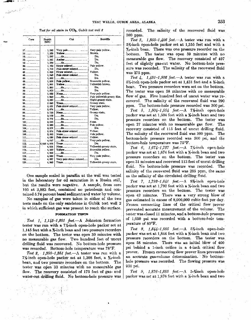
TEST WELLS, GUBIK AREA, ALASKA
Test for oil stain in CC4, Gubilc test well 2 -
Core Cut I Residffe
recorded. The salinity of the recovered fluid was 300 ppm.
Test 3, 1,355-1,402 feet.-A tester was run with a 5%-inch open-hole packer set at 1,355 feet and with a K6-inch bean. There was one pressure recorder on the bottom. The tester was open 59 minutes with no measurable gas flow. The recovery consisted of 497 feet of slightly gas-cut water. No bottom-hole pres- sure was recorded. The salinity of the recovered fluid was 275 ppm.
Test 4, 1,451-1,502 feet.-A tester was run with a 5%-inch open-hole packer set a t 1,431 feet and a %-inch bean. Two pressure recorders were set on the bottom. The tester was open 58 minutes with no measurable flow of gas. Five hundred feet of uncut water was re- covered. The salinity of the recovered fluid was 290 ppm. The bottom-hole pressure recorded was 300 psi.
Test 5, 1,504-1,554 feet.-A 7%-inch open-hole packer was set a t 1,504 feet with a %-inch bean and two pressure recorders on the bottom. The tester was open 27 minutes with no measurable gas flow. The recovery consisted of 115 feet of uncut drilling fluid. The salinity of the recovered fluid was 300 ppm. The bottom-hole pressure recorded was 500 psi, and the bottom-hole temperature was 75OF.
Test 6, 1,674-1,737 feet.-A 7%-inch open-hole packer was set at 1,674 feet with a %-inch bean and two pressure recorders on the bottom. The tester was open 31 minutes and recovered 113 feet of uncut drilling fluid. No bottom-hole pressure was recorded. The salinity of the recovered fluid was 285 ppm, the same as the salinity of the circulated drilling fluid.
Test 7, 1,792-1,841 feet.-A 9%-inch open-hole packer was set at 1,792 feet with a jh-inch bean and two pressure recorders on the bottom. The tester was open 42 minutes. There was a very strong blow of gas estimated in excess of 8,000,000 cubic feet per day. Frozen connecting lines of the critical flow prover prevented accurate measurement of the volume. The tester was closed 11 minutes, and a bottom-hole pressure of 1,050 psi was recorded with a bottom-hole tem- perature of 80°F.
Test 8, 1,8.&-1,886 feet.-A 5%-inch open-hole packer was set a t 1,844 feet with a %-inch bean and two pressure recorders on the bottom. The tester was open 58 minutes. There was an initial blow of 400 psi behind a l-inch orifice in a 4-inch critical flow prover. Frozen connecting flow prover lines prevented an accurate gas-volume determination. No bottom- hole pressure was recorded. The flowing pressure was 950 psi.
Test 9, 1,876-1,885 feet.-A 5-%inch open-hole packer was set at 1,876 feet with a %-inch bean and two
17.. .----...-. 18 .--.-.------ 18 . +
1 9 19 .-----...-.. N- . .
40 ----..-.-.-. 48 ----..-..--- . . .
49. -.--.-.---. 4 49 . .
49 . .
M). ---.---..-. 52 .-----.-.-.. 63- --.---.-.-. % . .
% . .
6 - - -- 88 ..------.... W . .
96 _-------....
97 . . 101 ---------.- 1 . .
1 1 0 6 - - - 1 . .
1 1 . 1 1 - - 112.. -----.-.- 1 1 3 . .
1 . .
117 . .
1 1 9 1 .
120-. ---------
One sample sealed in paraffin a t the well was tested in the laboratory for oil saturation in a Ruska still, but the results were negative. A sample, from core 105 at 3,883 feet, contained no petroleum and con- tained 5.74 percent basal sediment and water by volume.
No samples of gas were taken in either of the two tests made on the only sandstone in Gubik test well 2 in which sufIicient gas was present to reach the surface.
MIEMATION TBTS
Test 1, I ,146-1 ,201 feet.-A Johnston formation tester was run with a 7%-inch open-hole packer set a t 1,145 feet with a %-inch bean and two pressure recorders on the bottom. The tester was open 30 minutes with no measurable gas flow. Two hundred feet of uncut drilling fluid was recovered. No bottom-hole pressure was recorded. Bottom-hole temperature was 78OF.
Test 2, 1,508-1,36i feet.-A tester was run with a 7%-inch open-hole packer set a t 1,308 feet, a %-inch bean, and two pressure recorders on the bottom. The tester was open 33 minutes with no measurable gas flow. The recovery consisted of 175 feet of gas- and water-cut drilling fluid, No bottom-hole pressure was
1,342 . 1,359
1 3 , 1 1,702 1,710 1,843 1,846 2 1,866 1,881 1,866 8 7 2 1,932 1, gd8 3,632 3,646 3,661 3,674 3,7M 3,769 3 7 3,818 3,860 3 8 3,874 3,882 4,036 4,047
4,04M,068 4,058 4,232 4 4,330 4,837 4,342
,
Very pale ---._._. ...---.-- Yellow .-.-..-----.--.----.
- - 0 . .
h . .
- - 0 . .
8traw edored ----_-------.
Palestraw colored Btrawcalored ,------------ Palestran colored --.---.-.
d o Pale yellow --------....... Yellow -----..-------......
d o . .
d o . .
None -----..-.---.---.---.. --..-do .--.-.--.----------.. -----do ......-.---.----.-.-. Tracs -.-----.------------. Pale straw colored .--------
-----do ---------------.-..-. None -----..---------.-.-..
- - 0 . .
d o . .
-----do ------------.------.- -----do --.---------.----.--. d o . .
Pale straw colored .-.oreoreoreoreore. None ----..-.----.-....-.-. Pale straw colored ...------
----.do ---------.----.--.--- Trace ---.-.-..---.... ....
Nom ----.--..--.... ......
Yellow ----.---.- . .-...... d o . . . . .
Tracs ---------......------ Very pale straw colored.-- Trsce- --.-;-._.-----------
- Very M e yellow. Brown.
DO. DO. DO.
Pale yellow. Do.
Yellow. Do. Do.
Brownish yellow. Yellowish brown.
Do. Do.
Very pale yellow. Pale yellowish greasy film. Slight greasy stain. Greasy stain. Very pale yellow. Yellow. Greasy stain.
DO. DO.
None. Pale yellow.
Do. Yellow. Pale yellow. Yellow. Very pale yellow.
Do. Yellowish greasy stain. Brownish yellow.
DO. Very pale yellow.
Do. Yellowish greasy stain.
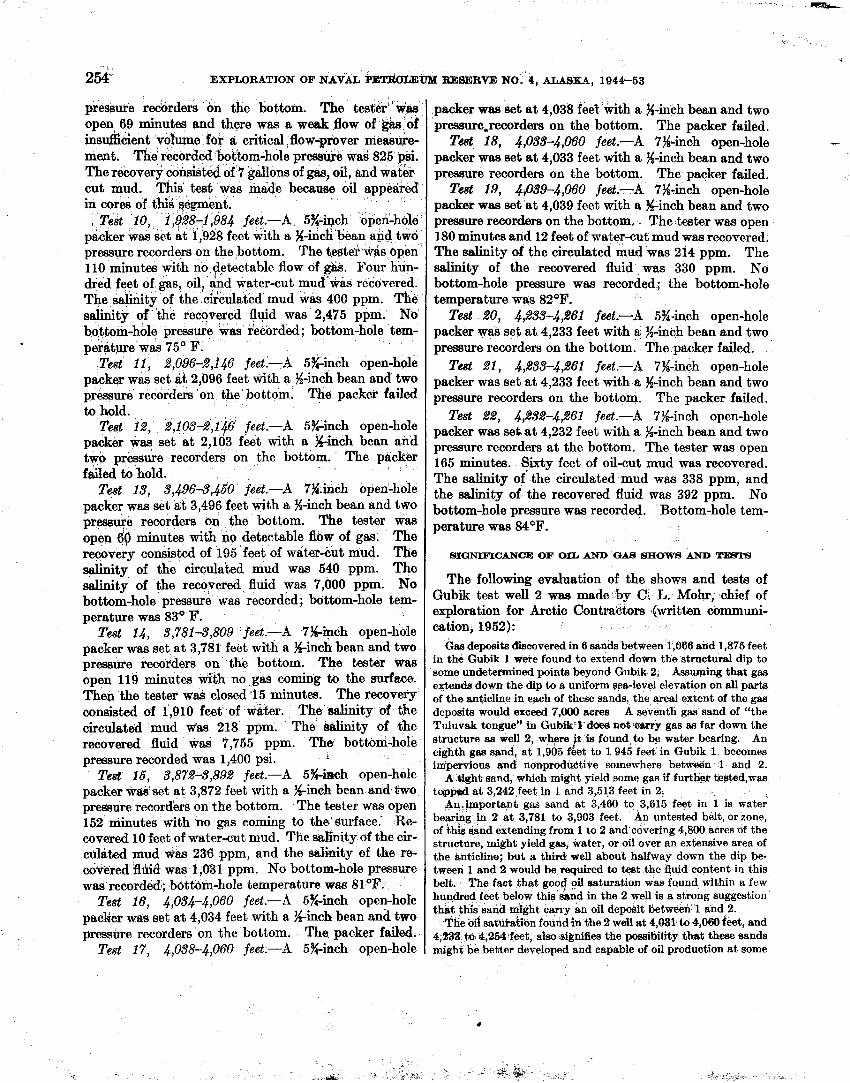
254- EXPLORATION OF N A V A L ' P E ~ ~ E ~ RE8ERVE NO. 4, ALASKA, 1944-53
pressure redorders on the bottom. The tester"was open 69 minutes and there was a weak flow of gh 'of insdcient volume for a critical flow-prover meas&- m a t . The recorded bohm-hole pressee was 825 psi. The recoverf consistd of 7 gallons of gas, oil, and water. cut mud. This test was made because oil appeared in cores of this segment.
, Test 10, 1 ;928-1,984 feet.-A 5%-kch oped-hble packer was set ati1,928 feet with a %-incGCbean and two pressure record- on the bottom. The te te r was &pen 110 minutes with no detectable flow of &. Four hun- dred feet of gas, oil, and water-cut mud was recovered. The salinity of the cifculated mud was 400 ppm. The salinity of the recovered fluid was 2,475 ppm. No bottom-hole pressure 'was recorded; bottom-hole tem- pe!rature was 75' F.
Test 11, 8,096-2,146 feet.-A 5%-inch open-hole packer was set at 2,096 feet with a %-inch bean and two pressure recorders on the bottom. The packer failed to bold.
Test 12, 2,103-2,146 feet ,-A 5%-inch open-hole packer was set at 2,lb3 feet with a %-inch bean and two pressure recorders on the bottom. The packer failed to hold.
Test 13, 3,4964,450 feet.-A 7g.inch open-hole packer was set a t 3,496 feet with a %-inch bean and two pressure recorders on the bottom. The tester was open 69 minutes with no detectable flow of gas. The recoveiy consisted of 195 feet of w a t e r ~ u t mud. The salinity of the circulated mud was 540 ppm. The salinity of the recovered fluid was 7,000 ppm. No bottom-hole pressure was recorded; bottom-hole tem- perature was 83' F.
Test 14, 3,781 4,809 feet .-A 7Kinch open-hole packer was set at 3,781 feet with a %-inch bean and two pressure reco~ders on the bottom. The tester was open 119 minutes with no gas coming to the surface. The0 the tester was closed .I5 minutes. The recovery consisted of 1,910 feet of wker. The salinity 02 the circulated mud Was 218 ppm. The salinity of the recovered fluid was 7,755 ppm. The bottom-hole pressure recorded was 1,400 psi. i
Test 16, 3,8724,892 feet.-A 5%-kwh open-hole packer was'set at 3,872 feet with a %-inch bean and %wo pressure recorders on the bottom. The tester was open 152 minutes with no gas coming to the'surface. R e covered 10 feet of water-cut mud. The salinity of the cir- culated mud was 23@ ppm, and the salinity of the re- covered fl1&3 WRS 1,031 ppm. No bottom-hole pressure was recorded; bott6m-hole temperature was 81°F.
Test 16, 4,034-4,060 feet.-A 5%-inch open-hole packer was set a% 4,034 feet with a %-inch bean and two pressure recorders on the bottom. The packer failed.
Test 17, 4,038-4,060 feet.-A 5%-inch open-hole
packer waa set a t 4,038 feet with a %-inch bean and two pressure,recorders on the bottom. The packer failed. T& 18, 4,033-4,060 feet .-A 7%-inch open-hole
packer was set a t 4,033 feet with a %-inch bean and two pressure recorders on the bottom. The packer failed. T& 19, 4,039-4,060 feet.-A 7%-inch open-hole
packer was set at 4,039 feet with a %-inch bean and two pressure recorders on the bottom, The tester was open 180 minutes and 12 feet of water-cut mud was recovered. The salinity of the circulated mud was 214 ppm. The salinity of the recovered fluid was 330 ppm. No bottom-hole pressure was recorded; the bottom-hole temperature was 82OF.
Test 20, 4,233-4,261 feet.-A 5%-inch open-hole packer was set a t 4,233 feet with a %-inch bean and two pressure recorders on the bottom. The packer failed.
Test dl , ~,233-4,261 feet .-A 7%-inch open-hole packer was set a t 4,233 feet with a %-inch bean and two pressure recorders on the bottom. The packer faiIed.
Test 22, 4,232-4,261 feet.-A 7%-inch open-hole packer was setat 4,232 feet with a %-inch bean and two pressure recorders a t the bottom. The tester was open 165 minutes. Sixty feet of oil-cut mud was recovered. The salinity of'the circulated mud was 338 ppm, and the salinity of the recovered fluid was 392 ppm. No bottom-hole pressure was recorded. Bottom-hole tem- perature ww 84OF.
SIGNIFICANCE OF OIL AND GAB SHOW8 A N D W T B
The following evaluation of the shows and tests of Gubik test well 2 was made by C. L. Mohr, chief of exploration for Arctic Contractors ,(written communi- cation, 1952):
Gas deposits &covered in 6 sands between 1;066 and 1,875 feet in the Gubik 1 were fdund to extend down the structural dip to some undetermined points beyond Gubik 2. Assuming that gas extends down the dip to a uniform sea-level elevation on all parts of the anticlipe in each of these sands. the areal extent of the gas deposits would exceed 7,000 acres A seventh gas sand of "the Tuluvak tongue" in Gubik't'd6es not carry gas as far down the structure as well 2, where t is found to be water bearing. An f eighth gas sand, at 1,905 feet to 1 945 feet in Gubik 1, becomes inipervions and nonproduOtive somewhere betwdn 1 and 2.
A iiight sand, which might yield some gas if furt- tded,was toppeplat 3,242 feet in 1 and 3,513 feet in 2,
An.important gas sand at 3,460 to 3,615 feet in 1 is water bearing in 2 at 3,781 to 3,903 feet. An untested belt, or zone, of this sand extending from 1 to 2 and covering 4,800 acres of the structure, might yield gas, water, or oil over an extensive area of the &ticline; but a third well about halfway down the dip be- tween 1 and 2 would be required to teat the fluid content in this belt. The fact that good oil saturation was found within a few huqdred feet below this &nd in the 2 well is a strong suggestion that this saqd might carry an oil deposit between 1 and 2.
The oil satheation found in the 2 wdi at 4,051 to 4,060 feet, and 4,233 t6 4,2M*feet, dm.signifies the possibility that them sands might be better developed and capable of oil production at some
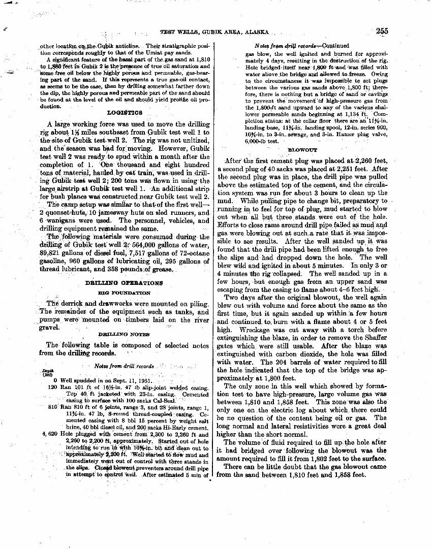
TEST WELLS, GUBIK AREA, ALASKA 255
other lwatiqn @@,hehGqbik anticline. The4 stratigraphic posi- tion corresponds r o u g e to that of the Umiat pay sands.
A significant feature of the basal part of the gas sand at 1,810 to 1#W h e t ih Gubik 2 ie t h e p ~ n c e of true oil saturation and m e free oil below the highly porous hnd permeable, gas-bear- ing part of the sand. If this represents a true gas-oil contact, as seems to be the case, then by drilling somewhat farther down the dip, the highly porous and permeable part of the sand should be found a t the level of the oil and should yield prolific oil pro- duction.
LOGI$TIGS
A large working force was used to move the drilling rig about 1% miles southeasf from Gubik test well 1 to the site of Gubik test well 2. The rig was not unitized, and the'seaaon Was bad for moving. However, Gubik test well 2 was ready to spud within a month after the completion of 1. One thousand and eight hundred tops of material, hauled by cat train, was used in drill- ing Gubik teed welI 2; 200 tons was flown in using the large &trip a t Gubik teat well 1. An additional strip for bush planes wss constructed near Gubik test well 2.
The camp setup was simiiar to thabof the first well- 2 quonset-hufs, 10 jamesway huts on sled runners, and 6 wanigans were used. The personnel, vehicles, and drilling equipment remained the same.
The ,fdowing rnatkrials were consumed during tbe &&ing of Gubik test- well % 564,000 gallons of water, 89,821 gallons of d i d fuel, 7,517 gallons of 72-octane gasoline, 960 gallons of lubricating oil, 295 gallons of thread lubricant, and 358 pounds of g~ease.
N o t a ~ Z M dfill recorkcontinued gas blow, the well ignited and burned for approxi- mately 4 days, resulting in the destruction of the rig. Hole bridged~itseif nem 1,800 ft;tmd-kv& filled with water above the bridge a M allowed to fsease, Owing t~ the circumstances it was impossible to set plugs between the various gas sands above 1,800 ft; there- fore, there is nothing but a bridge of sand or caving to prevent the movemeni bf high-pressure gas from the 1,800-ft sand upward to any of the veriqus shal- lower permeable sands beginning a t 1,134 ft: Com- pletion status: at the cellar floor there are an 11%-in. landing base, 11%-in. landing spool, 12-in. series 900, 10%-in. to 3-in. smage, and 3-in. Hamer plug valve, 6,000-lb test.
BLOWOUT
After the first cement plug was placed at2,260 feet, a second plug of 40 sacks was placed a t 2,251 feet. After the second plug was in place, the drill pipe was pulled above the estimated top of the cement, and the circula- tion system was run for about 3 hours to clean up the mud. Whiie pufling pipe to change bit, preparstory to running in to feel for top of plug, mud sta~ted to blow out when all but three stands were out of the hole. Efforts to close rams around drii pipe. failed E+R mud wd gas were blowing out a t such.& rate that it was .impos- sible to see results. After the well sanded up it was found that the drill pipe had been lifted enough to free the slips and had dropped down the hole. * The well blew wild and i g n i d in about 5 minutes. In only 3 or 4 minutes %lie rig collapsed. The well sanded up in a
DRaLINC3 OPERATIONS
ma rnUNDATION
The derrick ~ q d &tbwworks were ~ ~ ~ o u n t e d on piling. The remaindan of the equipment such as tanks, and Pumps were 'mounted on timbers laid on the river gravel. * ,
DEULLING NOTas C
The following table is composed of selected notes from the d d b g r d s . *
few hours, but enough gas from an upper sand was escaping from the casing to flame about 4-6 feet high.
Two days d te r the original blowout, the well again blew out with volume and force about the same as the first time, but i t again sanded up within 'a few hours and continued. to. burn with a flame about 4 or 5 feet high. Wreckage was cut away with a torch before extinguishing theablaze, in order to remove the Shafler gates which were still usable. After the blaze was extinguished with carbon dioxide, the hole was filled
Ndes from drill fecwda ' I *
m 0 Well spudded in on Sept. 11, 1951.
120 Ran LO1 ft of 16Yin. 47 ~b slip-joint wel&!d casing. Top 40 f t jaoketed with 23-in. cafling. Cemented casing to surface with 100 sacks Cd-Seal.
81° Rae 81° of 6 jainb, 3, 38 jdnts] range 1, 1l)i-in. 47 lb, &round thread-coupMfcwBg. Ce- mented casing with 8 bbl 15 percent by weight salt b~ine, 40 bbl dieat! oil, and 200 sacks Hi-Early cement.
4,620 Hole plugged with cement from 2,300 to 2,260 f t and 2,260 tg 2,200 ft, appro+ately. Started out of hole intending to run in *_th i d s i n . bit and kiean out to . 'h&&ximst~1~ $200 it. W-elk8farW $6 fldw mud and immediately w&t out of control with three stands in the dw, 01- ~ 0 - 6 prevenm amund drill pipe in a h m p t to epm well. After estimated s min of -
with kater. The 204 barrels of .water required to fill the hole indicated that the top of the bridge was ap- proximately a t 1,800 feet.
The only zone in this well which showed by forma- tion test t~ have high-pressure, large volume gas Was between 1,810 and 1,858 feet. This zone waa also the only one on the electric log about which there could be no question of the content being oil or gas. The long normal and lateral resistivities were a great deal b h e r than the short normal.
The volume of fluid required to fill up the hole after it had bridged over followkg the blowout ww &e amount required to fill i t from 1,802 feet to the surface.
There can be little doubt that the gas blowout came from the sand between 1,810 feet and 1,858 feet.
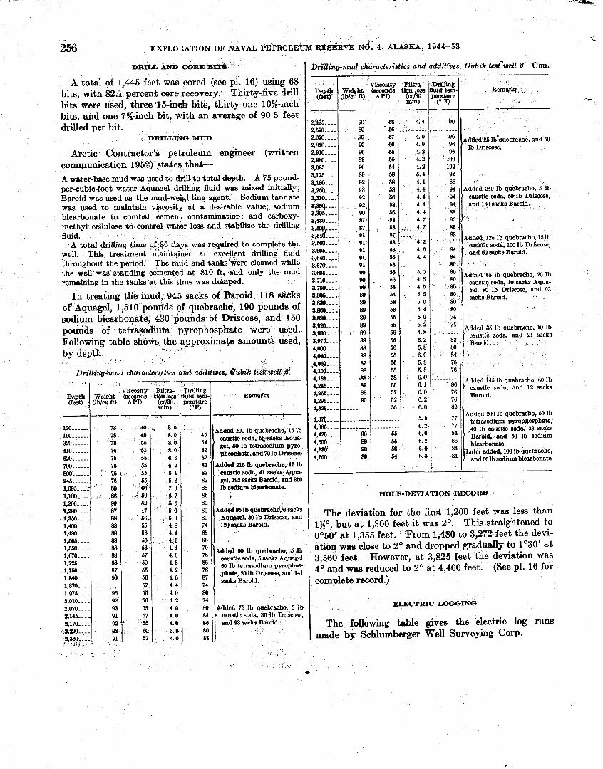
256 EXPLORATION OF NAVAL PETROLEUM
DRILL AND COREBIT& 7
A total of 1,445 feet was cored (see pl. 16) using 68 bits, with 82.1 percent core recovery. Thirty-five drill bits were used, th,l€i-inch bits, thirty-one 10%-inch bits, and one 7%-inch bit, with an average of 90.5 feet drilled per bit.
DR.II/LINC) MUD
Arctic Contraetor's petroleum engineer (written communication 1952) states that- A water-base mud was used to driU to total depth. A 75 pound- per-cubic-foot water-Aquagel drilfing fluid was mixed initially; Baroid was used as the mud-weighting agent;' Sodium tannate was used to maintain vigwsity a t a desirable value; sodium bicarbonate to combat cement contaminatio~: and carboxy- methyt cellulose to eonttol water loss and st.ab1li.e the drilling fluid. . .
A total drilling time +:86 days was required to complete the well. This treatment maintained an excellent drilling fluid throughout the period. The mud and tankshere cleaned while the well was standihg cemented at 810 ft , and only the mud remaiding in the tanks a t this time was dnmped.
In treaiing tlie mud, 945 sacks of Baroid, 118 sacks of'Aquage1) 1,510 pounds of cluebrachu, 190 pounds of sodium bicarbollatd, 430' pounds of Driscose, and 150 pounds of tetrasodium pyrophosphate were used. Following table shows the approxima@ amounti used,
'b. ,, by depth. L
Drilldng~mud characteristics aW additives, &ubik test: well 8'
I.%---. 8 8 . 50 4. 8 c a ~ t i c soda, 5 sacks Aquagel 3,560 feet. However, a t 3,825 feet the deviation was
55 4.2 l,7m---- 87 4O and was reduced to 2O a t 4,400 feet. (See pl. 16 for 1,84C.--- 90 56 4.6 1,870 - - - - ---------- 67 4.4 complete record.) 1,975 ...- 95 55 4.0 2,010. . . . 92 56 4.2 2,070.--- 93 55 4.0 ELECTRIC LOOQENC) 2 , 91 57 4.0 2,170- - - - 9 2 ' 66 4.0 The. following table gives the electric log runs
~.?~aaO,--- s% 6Q 3.8 2,3sa.. - - 91. 57 4.0 88 made by Schlumberger Well Surveying Corp. . .:, 3 .
MS~RVE NU: 4, ALASKA, 1944-53
Drilling-mud characteristics and additives, Gubik tes<well %--Con.
R m k s
Reqarlg ,
'
~dded'26 lbgquebraeho, and 50 ' lb Driscose.
- Added 240 Ib quebracho, 5 lb • caustic soda, ~t lb Drisoose,
-and 180 sacks qaroid.
. .
, Filtra- tionloss (oc/30 mln) ii--
Viscosity (seconds
API)
.
Depth (teet) : -
Filtra-
YE;&= .' m) --~- 4.4
- -. - - - -- - 4.0 4.0 4.2 4.2 4.2 5.4 4.4 4.4 4.4 4.4 4.4 4.7
viscosity
(Ep"
9 0 . 56 56 57 80 55 55 54 58 58 58 66
: 58 56 58
- 2,495-.. - 2,;6gg.---
2,630.-.- 2,810.- - - 2,910---- 2,ssO.--- 3,~95-.--
zz::i: , 3,ao---- m--- 3*395----
Drilling fluid Bem- perature
( O F )
,
Wei&bt Ob/wft)
Drintng
zz- c0 F)
90' - -- - - - - - . .
@6
w , 400
102 92 88 94 94 94 88
$,st)
89 .W)
W)
w 89 W)
88
93 92
92. 90 87 :'-:::
a,&--- 3.m---- 3*m----
3,695..-. 3,710- - - - 3,750--.- 3,m--,-.
2z:::: 3m.---
tz:::; 3,975-..- 4,000.--- 4,@&3----
&Oea...- %lo@---- 4,1%---- 4,2a..-- 4,265. - - . 4,295-. -. 4,316
4,370 .--- 4,380 -.-- :;;:::: ;g; : : :
1,SbO- - - - 88 53 4.4 a quebracho, 1,670. - -. 88 57 4.6
8.0 8.0, 8.0 8.0 6.3 6.2 6. 2. 5.8 7.0 0.7 5.6
" 5.0 5.0 4.8 4.4 4.6
4 0 . 40 55 61. 55 59 55 55 66
: 5 9 52 47 56 55 58 55
l!i~l------ 160------ 320--...- 410--.--- 820,----- 700--.--- 800- ---- 945------ 1,095.---' 1 1 1,20Ll - - - 1,280.---
- 1,360..,.. 1,400- .. - . 1,480-. - - 1,605-. - -
HOLE-DEVIATION, @ECOR@
The deviation for the first 1,200 feet was less than lgO, but a t 1,300 feet it was 2O. This straightened to 0'50' a t 1,355 feet. From 1,480 to 3,272 feet the devi- ation was close to 2O and dropped gradually to 1°30' at
87 91 91
91 gl w w . 90 8s - 89 89 89 89 , 89 88 88 87 88 JB'? a 88 w
--....-.--..-- ----.----- ----------
BO 89 80
58 , , 4.7
126 lb quebracho, l5lb
58 , 4.6 84 56 4 . 4
58 - -. - - -. -. . 56 5.0 56 4.5 58 4.5 gel, 80 Ib Driseose, and 93 54 5.5
78 78 %3 76 75 76
, 78 76 80
90 87 88 88 88 88
58 58 55 55 56 55 56 5 5 : 5 6 - 55 58 55 57 52 55
.-----..--
-.-----.-.
55 55 ' 54
---------- Adddl 1001h quebMcho, kb Oaastlo soda, b&eacks bqua- gel, Eil Ih t e t r d u m pyro- phos@tate, and 70 lb Drimw
82 '
Added 216 Ib quebracho, 16 Ib caustic soda, U m&s,Aqua-
82 gel, 192 sacks Baroid, and 360 88 lb sodium bicarkmate. 86 80 80
74 68
5 0 5.4 5.0 5.2 4.8 6.2 5.8 6.0 5.8 5.8 6.0 6. 1 6.0 6.2 6.0
5.8 6.2 6.0 6.2
6.3
Added 95 lb quebraoha,'~ dscks , , a , and
la4 WLS ~aroid.
RO 74 74
----------
2 $ . 84
76 76
.-.-..--.-
-
,
Added 35 lb quebryho, 10 lb ' causti'c soda, and 21 sacks
Barold.
'
Added 145 lb quebracho, 60 lb
82
77
86 '
r
caustic soda, and 12 sacks Baroid.
Added 200 1b quebraoho, 50 lb tetrasodium pppbosphste, 40 lb caustic soda, 33 sacks
' Barold, and W Ib sodium bicarbonate.
Later added, 100 1b quebracho, , and 50lb sodium bicarbonate
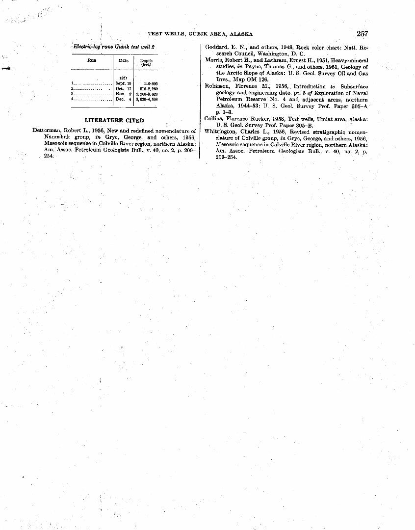
TEST WELLS, GUBIK AREA, ALASKA 257
Goddard, E. N., and others, 1948, Rock color chart: Natl. Re- search Council, Washington, D. C.
Morris, Robert H., and Lathram, Ernest H., 1951, Heavy-mineral studies, in Payne, Thomas G., and others, 1951, Geology of the Arctic Slope of Alaska: U. S. Geol. Survey Oil and Gas Invs., Map OM 126.
Robinson, Florence M., 1956, Introduction to Subsurface geology and engineering data, pt. 5 of Exploration of Naval Petroleum Reserve No. 4 and adjacent areas, northern Alaska, 1944-53: IT. S. Geol. Survey Prof. Paper 305-A p. 1-3.
Collins, Florence Rucker, 1958, Test we&, Umiat area, Alaska: U. S. Geol. Survey Prof. Paper 305-B.
Whittington, Charles L., 1956, Revised stratigraphic nomen- clature of Colville group, in Gryc, George, and others, 1956, Mesozoic sequence in Colville River region, northern Alaska: Am. Assoc. Petroleum Geologists Bull., v. 40, no. 2, p. 209-254.
Eledriebg runs Cubik test well 8
Ron
-?Pr
1 .-.. .--...-.------- 2 ............ 3 .-.-.--.-.-...-.--._ 4 -_-.-.........---.._
LITERATURE CITED
Detterman, Robert L., 1958, New and redefined nomenclature of Nanushuk group, in Gryc, George, and others, 1956, Mesozoic sequence in Colville River region, northern Alaska: Am. Assoc. Petroleum Geologists Bull., v. 40, no. 2, p. 209- 254.
Date
------- IQSI
Gept. 19 0 0 . 17 NOV. 2 Dee. 4
Depth (feet)
116-800 810-2,260
2,~604,620 3,620-4,598
MICROPiUEONTOL001IC STUDY OF THE GUBIK TEST WELLS, NORTHERN ALASKA
Beneath thin surficid deposits of Pleistocene age, a sequence of about 3,300-3,500 feet of beds of the Col- ville group of Late Cretaceous age was penetzated in the two test wells drilled on the Gubik anticline. Under- lying these beds are approximately 2,700 feet of sedi- mentary rocks of the Manushuk grodp of Early Cre- taceous age penetrated in test well 1 and a little more tban 1,000 feet of beds of the same group in test well 2. Foraminifhk& and some Radiolaria occur a t inter- vals throughout the Colville group in both wells, but were abundant in only a few samples. Foraminifera are more common in the-Nanushuk group but are poorly preserved. Many of the species of Foraminifera are new and have been recently described by Mrs. Helen Tappan Loeblich (Tappsn, 1951, 1957). Others have been identi6ed as speci-es described from beds of Ceno- manian and Turonian age in western Canada by C. R. Stelck m.d J. H. WallL(1954, 1955) and A. W. Nauss (1947, p, 329-434).
Both Gubik test well 1 and Gubik test well 2 started in the Schrader Bluff formation of Senonian age, as determined from certain diagnostic species of Forami- nifera. Three of these are Anomalinoides pinguis (Jennings), NonioneUcG awtiwna Cushman, and Prae- bulimina venuscce (Naw) . Tbe first two species are known in beds of Austin to Navarro age in Texas and the last-mentioned was described from the Belly River formation in Alberta. [A few other Foraminifera and Radiolaria found in the Schrader Bluff formation are species that range throyghqut the Colville group.
Below the Schrader Bluif forma&ion and above the Seabe? formation is a pectjq,%v&ch in test well 1 is composed of 870 feet of xi6ikossi1iferous beds and in test well 2 of 883 feet of beds that are largely nonfos- siliferous, but interbedded with them are some thin beds containing, Foraminifera and Radiolaria. These beds are appasmtly p a r k of the Tuluvak tongue of the nonmarine Prince Creek formation.
Strata identified as the Seabee formation of Turonian age are Eibout the sam$~thickness (1,945 and 1,575 ft) in the two wells yet they 'are quite dissimilar in fossil content. In test well 1 % b c b ~ e s were barren, and only Inoceramw p k h s were' fomd. Specimens of Haplo- ph-&8 Pa!& N a w w& cxxbmon in two ditch , ' c 9 .:q ,. s -
samples. In test well 2, specimens of Pseudocladina hastata (Cushman) and Arenobulimina torula Tappan a t the top of the section identify these beds as the upper part of the Seabee formation. Associated species are Haplophragmoides rota and Praebulimina seabeensis Tappan. Some other species of Foraminifera and a few species of Radiolaria were found in core and ditch sampIes, but these are species that range throughout the Colville group, and none are diagnostic of the Seabee formation.
In the Gubik wells an abrupt change in microfossils to a thin zone of Gaudryina canadensis Cushman and Trochammina rutherfordi Stelck and Wall indicates the change from the Seabee formation to the Ninuluk for- mation of the Nanushuk group. These spe,cies are known to be characteristic of the Ninuluk formation in other areas. Furthermore, since T. rmtherfordi is de- scribed from Cenomanian beds in the lower part of the Kaskapau formation in western Canada, its 'relative abundance in the Ninuluk formation supports the Cenomanian age ascribed to it.
A distinctive faunal zone of Albian age underlies the Cenomanian strata, This is the Verneuilin&s borealis faunal zone, so named from the distinctive fossil that is abundant within it. In some areas the associated Foraminifera number a great many species, and some are the same as species known in Albian beds in Eu- rope. In the G u b i wells, however, the species are limited to 3 or 4 in the upper part of the zone and a' half dozen or so species in the lower part of the fawal zone. Approximately 2,265 feet of beds of the Ver- neuilinoideg borealis zone was penetrated in test well 1, but the zone is poorly developed in the lower few hun- dred feet of the section. Specimens of Ammobwulites fragmenturiw Cushman and Trochammina umicctensis Tappan found in test well 2 are the same as those
3 - found in the Umiat area.
GCUBIK TEST WELL 1
BCHRADBIR BLUFF FORMATION (6q-8W)
A few scattered Foraminifera occurred in.$he upp~r 500 feet of beds. Inoceramus prism were btmd .in samples from 495-595 feet and 785-865 feet. Three-
269
260 EXPLORATION O F NAVAL PETROLEUM RESERVE NO. 4, ALSAKA, 1944-53
species of Radiolaria were common in a sample from 525-535 feet, and a few Radiolaria occurred in samples from 815-885 feet. Two or three specie8 of Foraminifera were found in the lower beds. In the core from 731-741 feet , Verneuilinoirbasficheri Tappan was abundant, aad Trociucmmina diagonsis? (Carsey) was common. A few tests of Nonionella austinana Cushman and Praebu- limina venusae (Nauss) occurred in ditch samples. - TULWAK TONGUE OF THE PRINCE CREEK FORMATION
(890-1,788 FEET)
The cores were unfossiliferous except for Inoceramus prisms found in three. Scattered Foraminifera and a few Radiolaria were found in some ditch samples. None of the fossils were diagnostic, for the species range throughout the Colville group of sedimentary rocks.
SEABEE FORMATION (1,760-8,805 FEET)
Most of the cores were barren except for Inoceramus prisms. The only ditch samples having any degree of abundance of Foraminifera were from 1,910-2,000 feet; Haplophragmoides rota Nauss was common in two samples.
m t ~ K FORMBTION AND lTTTlTlTR TONGUE OF THE CHANDLER FORMATION ( 3 , ~ 8 , W FEET)
Fossils were found in only 1 sample, a core from 3,342-3,352 feet, in which were 4 species of Foram- inifera and 1 species of Radiolaria; Sacoammina sp. and Gaudryzryzna canadensis Cushman were common.
Haplophragmoides topagorukensis Tappan was very abundant in a core from 4,3524,372 feet. This species and specimens of Trochummina mctherfordi Stelck and Wall were common in a ditch sample from 4,4104,415 feet. T. rmtb~fwdi was also the most frequently occur- ring species in many of the ditch samples, but there were very few specimens in each one. A core from 5,100- 5,.1.15 feet had common specimens of Haplophragmoides topagorukensis and Verneuilinoides borealis and 1 or more specimens each of 10 other species; 8 specimens of GaudryineUa irregdaris Tappan were foremost of this secondary group.
Only a few Foraminifera, generally V . borealis and T . rutherfmdi, occurred in most of the samples through- out the underlying beds from 5,115 feet to the bottom of the hole. Very few specimens were. found in the lower cores. Haplophragmoides topagorukensis was common, and V . borealis very abundant in a ditch sample from 5,270-5,280 feet, and T. rutherfordi was very abundant in a sample from 5,510-5,520 feet. Of the few calcareous Foraminifera, Nanushukella umiat- ensis Tappan and Globwotalites alaskensis Tappan each occurred in five samples. A core sample from 5,758- 5,768 feet had common specimens of Theocampe? sp. and a few other specimens of Radiolaria, but only four specimens of Foraminifera were found in it. In a bottom core a few specimens of T. rutherfordi and Nan- ushukeUcG umiatensis were identified, and a few others were questionably referred to three species.
VWNEUILINOWEB BOREALIS FAUNAL ZONE (3,785 FEET I GUBIK TEST WELL 2 TO TOTAL DEPTH)
Specimens of the Verneuilinoides borealis fauna were relatively abundant throughout much of the interval from 3,8054,100 feet. Verneuilinoides borealis Tappan, the species for which the fauna is named, occurred most frequently and was common in several samples. A core from 3,900-3,920 feet was very fossiliferous, having common to abundant specimens of V . borealis, Saceammina sp., Miliammina ischnia Tappan, Trochum- mina rutherfordi Stelck and Wall, Trochammina umiut- e& Tappan, R e o p h sp., Vul&neria loetterlei Tappan, and Zonodiscw sp., ~ l u s a few specimens of a half dozen other species. The fauna is sparse in samples from 4,100-4,190 feet, and the lower beds are barren except for 2 or 3 occurrences of Inoceramus prisms in ditch samples and a fragment of Dilrupa sp.' in a core from 4,2954,305 feet.
Occurrences of Foraminifera below 4,000 feet were scattered through beds to a depth of 5,100 feet, and in only 2 or 3 samples were specimens of 1 species common.
1 am& tabular shells &om t b m-~8 beds of A I ~ S ~ were for. e r n - to h d h t a l b n , q . o r ~ d i t e m SD. ~berleimtions by ~ a b h W. 1ml.y show that these shells are not scaphopods but, are worm tubes of the genus -pa.
SCHRADW BLUFF FORMATION (1603,135 FEET)
No microfossil samples were received for the upper 160 feet of section. Scattered Inoceramus prisms, a few specimens of Haplophragmoides rota and Vmuilinoides Jischeri, and a very few specimens of Anomalinoides pinguis (Jennings) constitute the fauna found in the upper 700 feet of section in this well. In the lower beds of the Schrader Bluff formation, V.$scheri was found in several samples and was common in a core from 810- 820 feet. Tests of Nonionella austinana Cushman and Praebulimina venusae (Nauss) occurred in samples below 720 feet. Radiolaria were common in several smples. In a sample from 780 feet, Cemsphaera sp. and Spongodiscus sp. were common; in samples from 1,000 feet through 1,060 feet, the same species were common, plus a few other Radiolaria.
TOLWILK OF THE PRJNRJNCE RMATION (1,185-~,010 WEWF)
Most of the cores were. unfOSs~ferous, but in some of the continuously cored intervals rare occurrences of foW& we mnsPiCww. The fauna of the Tuluvak is slightly different from that of the overlying Schrade
TEST WELLS, GUBIK AREA, ALASKA 261
Bluff formation. Specimens of Trochammina rib- stonensis Wickenden and Gaudryina irenensis Stelck and Wall were scattered through samples from the section. Both of these species and Verneuilinoides Jischeri Tappan were common in a core from 1,340-1,351 feet. In a core sample from 1,482-1,502 feet, T. rib- stonensis was common to abundant. A few Forami- nifera of the same species occurred in a core from 1,578- 1,580 feet. In a core from 1,731-1,737 feet, Saccam- mina sp. and Trochammina whittingtonil Tappan were both common. The continuously cored section from 1,813 feet through 1,984 feet was unfossiliferous except for some plant imprints a t 1,915 feet.
SEABEE FORMATION (!2,010-t3,886 FEET)
In the upper part of the Seabee formation from 2,129 feet to 2,218 feet is a conspicuous fauna in which Haplophragmoides rota is abundant and Pseudoclavulina hastata (Cushman) and Arenobulimina torula Tappan occur. Because regional studies seemingly indicate that these two species are limited to the upper part of the Seabee formation, I have designated that part of the section as the Pseudoclamdina-Arenobulimina faunal zone. A few specimens of Praebulimina seabeensis Tajpan and a few Radiolaria were associated with the fauna in this well. In one sample (2,180-2,190 feet) Zonodiscus sp. was common.
Throughout most of the rest of the Seabee formation below the Pseudoclavulina-Arenobdimina zone, species of Foraminifera and Radiolaria are rare, and only a few specimens were found-exceptions to this follow. A ditch sample from 3,030-3,040 feet in which there were no Foraminifera but Spongurus sp. was common. A core sample from 3,100-3,110 feet had common speci- mens of Gaudyina irenensis? and an abundance of Trochammina diagonist. Zonodiscus sp. was common in a ditch sample from 3,150-3,155 feet, and Inoceramus prisms were found in several core and ditch samples low in the section. In a core sample from 3,368- 3,380 feet, Qiimbelitriu cretacea dbertensis Stelck and Wall was common.
NINULW FORMATION AND KIlXIK TONGUE OF TBE CHANDLER FORMATION UNDIFFEREN'I'IATED (8,88&4,025 FEET)
The section was unfossiliferous excepting a core sample near the top from 3,620-3,630 feet, which had common specimens of Saccamminu sp. and Trochammina rutherfordi, abundant specimens of Gaudryina cana- densis, and a few specimens of Miliammina ischnia and Zonodiscus sp.
-0IDW BOREALIS FAUNAL ZONE (4,025 FEET TO TOTAL DEPTH)
The top of the Verneuilinoides borealis fauna occurs in a sample from 4,0254,030 feet. Only a few Foram- inifera were present in the sample, but in a core sample from 4,060-4,075 feet, Haplophragmoides topagoruk- ensis Tappan was common. Ditrupa sp. occurred in a core from 4,0584,060 feet. Verneuiiinoides borealis was common in a sample from 4,150 feet, and a few specimens of Ammobaculites fragmentarius Cushman were found in a sample from 4,210 feet. Specimens of Trochammina umiatensis were common in samples from 4,180, 4,210, and 4,225-4,230 feet. Few Foram- inifera occurred in the samples from lower beds in the test well, and several of the cores were barren.
BIBLIOGRAPHY OF THE MICROPALEONTOLOGIC STUDY
Nauss, A. W., 1947, Cretaceous fossils of Alberta; Jour. Paleon- tology, v. 21, no. 4, p. 329-434.
Stelck, C. R., and Wall, J. H., 1954, Kaskapau Foraminifera from Peace River area of western Canada: Prov. of Alberta, Res. Council Rept. no. 68.
Stelck, C. R., and Wall, J. H., 1955, Foraminifera of the Ceno- manian Dunveganoceras zone from Peace River area of western Canada: Prov. of Alberta, Res. Council Rept. no. 70.
Tappan, Helen, 1951, Northern Alaska Index Foraminifera, Contrib. Cushman Foundation Forsm. Research, v. 2, pt. 1, p. 1-8, pl. 1.
Tappan, Helen, 1957, New Cretaceous Foraminifera from northern Alaska: U. S. Natl. Mus. Bull. 215.
Wickenden, R. T. D., 1932, New species of Foraminifera from the Upper Cretaceous of the Prairie Provinces: Royal Soc. Canada. Proc. and Trans. 3d ser., v. 26, sec. 4, p. 85-92, pi. 1.

M f u m sp ..-~------~.-----fffffffffffff ------- ----- f f f f f f f f f f f f f f f f f f f 260 dfaponfs, !lYodrcrmmfna ....------------------------------------------------ 260,281 DWtLfM Sp .-. - - - - - - - . - - - - -papapapapapapapapapapapapapapapapapapapapapapapapapapapapapapapapapapapapapapapapa 225,249,260,261 Drill and core bits, Oubik test well 1 .--.-------...-.------------------------- 229
Qubik test well 2 ----------.-------------------------------------- 256 p m u b test w I 229
Drilling fluid, Qubik test well I---, ----..------.--------------------------- 230-231 Q ~ b k well 2 --.-..--.-.---,------------ .-----...----.------- ..------- 256
D m notas, Qubik &St well I..-, --.-.-.--.--.---------------------------- 229 u b t w 2 - - - 265
DrUhg operations. (Srs Qubik teaL well 1 and Oubk test well 2.)
I N D E X
Electsic logging, Qubik test well 1 ..--.------.----.-fffffffffff f f f f f f f f f f f . f f - 231 a ~ b i k fZSt well 2 --------------- L ---.------------------------- ---- --- --- 25E-257
l3ntdiumsp ---....-.--....------------ -----------------.-------------------- 225
Page
Abstract ........--.----------------------------------------------------------- 207 Acbrowledgm%nts ..-.tststststststststststststststststststststststststststststststststststststststststststs--tststs-ts-tststststs 207 , W 260 -8, ~ & d ~ a d a c s o ..-----.-~~~-iM.iM.iM.iM.iM.iM.iM.iM.iM.iM.iM.iM.iM.iM.iM.iM.iM.iM.iM.iM.iM.iM.iM.iM.iM.iM.iM.iM.iM.iM.iM.iM.iM.iM.iM. 261 Albian ase_ -.--.-.-.-.-.----------------------------------------------------- we A l l u d o ~ , Quaternary .------------------------------------------------------- 209 AmmbwmlaU f qnnddw UI.UIUIUIUIUIUIUIUIUIUIUIUIUIUIUIUIUIUIUIUIUIUIUIUIUIUIUIUIUIUIUIUIUIUIUIUIUIUIUIUIUIUIUIUIUIUI 259,261 AnornoUnoUu pingui~ -.------.-.-.------------------- .-.-...------------. -- 269,260 Ar&k Contractors, quoted ---..-.------tedtedtedtedtedtedtedtedtedtedtedtedtedtedtedtedtedtedtedtedtedtedtedtedtedtedtedtedtedtedtedted M9,230,268 A& sp .--.-----..-.-.------------------------------------------.---------- 222 Armobulimina tMu&-. . . ---.-.-.-.II)II)II)II)II)II)II)II)II)II)II)II)II) 11)11)11)11)11)11)11)11) II)II)II)II)II)II)II)II)II)II)II)II)II)II)II)II)II) --- 259,261 A r c m b M m f n a - P & W m faunal mne ..-~~..~.--..--1M1M1M1M1M1M~1M1M1M1M1M1M1M1M1M1M1M1M~ 261 aclslinuna, h r m i o ~ & ~. . - .~~~-~nanananananananananananananananananananananananananananananananananananananananananana -- 259,260 Ayiyak member -----.-.------------------------------------------------------ 210
Barrow Trail member, B c h r s d ~ ~ Bhfl bmtbn-------------------- 20Q,214,231,232 Belly River formstfon, Alberta----------------------------------------------- 2.59 Biblbgraph~ to ~ ~ ~ ~ ~ a n d ~ n % l M e r t n g d ~ ~ ~ s e c t ~ ~ - - - - - - - - - - - - - - - - - - - - - - - - - 257 BibNography tomiuo~aleonto~~Ystud~---.--------------------------------- 261 Blowodt, Qublk test well2 .-.- ---.------- --.- -----------------------------.-- 255 boredh, V a r n C u i i l ~ .-..---- ---------- ---- . . . . . . . . . . . . . . . . . . . . . . . . 212,260,281 bored& faunnl mne, Va))cuflfd~----------------------------------------- 259,261
canatWwi8, Gawlryinu .-..----.------------------------------------------ 268,260,261 Cenomanies age -..--------..------------------------------------------------- 259 Cemphocra sp - - - . . . -~~-- - . . - - -hocrhocrhocr.hocrhocrhocrhocrhocrhocrhocrhocrhocrhocrhocrhocrhocrhocrhocrhocrhocrhocrhocrhocrhocrhocrhocrhocrhocrhocrhocrhocrhocrhocrhocrhocrhocrhocrhocrhocrhocr hocrhocrhocrhocrhocr 260 Chandler and Nfnduk formationsmd*erenthted--------ererererer 211~214~2211231*246 Chandler River -..--------...----------------------------------------------- 212,231 Colviue group @W -us)---------------------------------- 206-211,259,260 ColvlIIe River ---.--------..------------.------------------------------------ 212 Core analyses, Qublg teat well 1 ---------..--.--.---------------------------- 237
Qubik test well 2 -...--.-..-.-----.--- ------ ---- --------------- 251-262,260-261 Cores and cuttings, description, Qubik test well 1 -...-.-------.-..-----. .._ 214-227
aublk test well 2. --.-------------------------- .................... ----- 231-251 Core and drill bits. Qublk test well 1- .-..-.---..-..-.---.------..-----.----.- 229
Qubik test well2 --..--.-.-.---.--.--------------------------------------- 256 C t d n a l a cleflam .-------.-.------------------------------------------------- 218
sp-. --..-----.-------------.----------------------------------- ------- -- - 235 ctdocca albertunafu, G&nbeIiMc ~ . ~ ~ - - - - M c M c M c M c M c M c M c M c M c M c M c M c M c M c M c M c M c M c M c M c M c M c M c M c M c M c M c M c M c M c M c M c M c M c M c M c M c M c M c M c 261 O~BWUS .-----------------------------.------------------------------------ 259 ore taw^^ r& - - . - ~ - - - - - - ~ . U S U S U S U S U S U S U S U S U S U S U S U S U S U S U S U S U S U S U S U S U S U S U S U S U S U S U S U S U S U S U S U S U S U S U S U S U S U S U S U S U S U S U S U S U S U S 20~-212
Inoec~amw krMohrs ------.--.--O.OOOOOOOOOOOOOOOOOOOOOOOOOOOO..OOOOOOOOOOOOO 211,219 lU&b~~ciulMia .--------------------------------------------------------- 210,215 Sp ..------.-------.-------------.-------.---.--------------------------- 214,215,
217,21& 219, aaO,221, !ZB, 225,232,234,2(2 24.?,~,245,246,249,259,260,261 o d u i o - - 207 irenesia, Uaudryinana. --.----.------------------------------------------------- 261 r r e a . - 260 ischnia. M'fliammlna --.----ia.iaiaiaiaiaia -. ----- -iaiaiaia-iaiaiaiaiaiaiaiaiaiaiaiaiaiaiaiaiaiaiaiaiaiaiaiaiaiaiaia 260,261
Page
Uaudryinu wna&nr& .--.----..- iiiiiiiiiiiiiiiiiiiiiiiiiiiiiiiiiiiiiiii 269,260,261 bctlcnata -----.--.-.------------------------------------------------------- 261
UavdrdneUa irrcouhrls -....-----...-----.--rlsrlsrlsrlsrlsrlsrlsrlsrlsrlsrlsrlsrlsrlsrlsrlsrlsrlsrlsrlsrlsrlsrlsrlsrlsrlsrlsrlsrlsrlsrlsrlsrlsrls 260 uloborhl&d dcuk#dJ ....-----.-.-------.----------------------------------- 260 Grandstand formation -.--..--..tiontiontiontiontiontiontiontiontiontion.tiontiontiontiontiontiontiontiontiontiontiontiontiontiontion 211-212,214,224,231,249 Qubik ant idhe ----------.----------------------------------------- 211,212,231,269 Qubik formation ........................................................... 214,231 Qubik test well 1 ..-. .-------..------------------------------------- 2lS231, 259-260
227 corn and cuttings, desQiptlon ----------------------------------------.- 214-227 drfll and core bits ---------.-------------- ................................ 230 i l l and r e b 256 drilling notes. - . - - -~- - - - - . -nanananananananananananananananananananananananananananananananananananananananananana -- 228-230 drilllug operations .-----.----------------------------------------------- 228-231 electric logging ..-.----.----------------------------------------------- f131 hole-deviation record - - ~ . ~ ~ ~ - - - . - . ~ - - - ~ ~ ~ ~ - - - ~ ~ ~ ~ ~ ~ ~ ~ ~ ~ ~ ~ ~ ~ ~ ~ ~ - ~ - ~ ~ ~ ~ ~ - - - ~ 231 mud-- .................................................................. -231 ou and gas .............................................................. zzem
Qubik test well 2 ........................................................... 231-2.57 blowout -..---.----------------------------------------------------------- 255 wre analyses.. ...-----.-------._-1212121212121212121212121212121212121212121212121212121212121212121212121212 251-%2 cores and cuttings, description . - - - - - . . - B S B S B S B S B S B S B S B S B S B S B S B S B S B S B S B S B S B S B S B S B S B S B S B S B S B S B S B S B S B S B S B S B S 231-261 drilling operations -.--.-------.---------------------------------------- 266-257 c 0 - - - - 255267 f0rIUati011 tests .-.....--------------------------------------------------- 263-264 fOlTXl8tiOIl tests, S @ l i f b U ~ of-. ._---._-- ----.~eeeeeeeeeeeeeeeeeeeeeeeeeeeeeeeeeeeeeeeeeeeeeeeeee 254-266 hole-deviation record.. .----.- ---- ..- -- -- - e r e r e r e r e r e r e r e r e r e r e r e r e r e r e r e r e r e r e r e r e r e r e r e r e r e r e r ----- a58 logistics -...--_.----------------------------------------------------------- 255 ~ c r o ~ e o n t o l o g y of .................................................... 260-261 ofl and gaq -----.-.-...-------------------------------------------------- 262-266 rig d a t i o 256 Shows -..-------.------------------------------------------------------ 252-253
signiflcanw of - . - - - - - - . ~ - . - - - . ~ C B n C B n C B n C B n C B n C B n C B n C B n C B n C B n C B n C B n C B n C B n C B n C B n C B n C B n C B n C B n C B n C B n C B n C B n C B n C B n C B n C B n C B n C B n C B n C B n C B n C B n C B n C B n C B n 254-255 Udmbelitria erctaeea albertsnsia-. . .-.------------------------------------------ 261
Ha~lophraflfnof&8 r&- -..- - - - - . - - - - - 8 - 8 - - - - - 8 - - - - 8 8 8 8 8 8 8 8 8 8 8 8 8 8 8 8 8 8 - 8 8 - 259,260,261 twagorzlknsis ....------------.--------------------------------------- 260,261
hmtata, p .w~d~arml inu. - - - ------ -- ------------ - --11(111(111(111(1-11(1-11(111(111(111(1--11(1-11(111(1----11(1-11(1- - 259,261 Heaw-mineral studias ..----.-------------.---------------------------------- 213 Hole-deviation record, Qubik test well 1 ------.------.------------------------ 231
Qubik test well 2 . - - - . . - ~ - - . ~ ~ . ~ ~ - - U S ~ U S U S U S U S U S U S U S U S U S ~ ~ ~ U S U S U S ~ U S ~ ~ U S U S U S U S U S U S ~ ~ ~ U S U S U S U S ~ U S U S U S U S 256 Housing, Qubig test well I-. .-----...----._-----..-------------..-.---------- 229
Kaskapau formation, Canada --..-.-___._------------------------ ------------- 259 KWk tongue of the Chandler formation- .----..---.-------.----- 211,214,221,231,246
labiatw, Inoerramud -..-...-------------------------------------------------- 211,218 M d e n t a l i u m sp ..-----..--.------------------------------------------------- 260 l o e t r k V i a - - 260 Logistics, Gublk test well 1 .-_----------.------------------------------------ 229
Qabik test well 2 --.--.----...--------------------------.--------..-----.- 266 Lubricant cmsnmption, Qubik test well 1 .-.-.---...------_.-------.-------.. 239
Qubik test well 2 .---..----_------..--.---.------------------------------- 255 lundbreckellbis, Inoclramw ---.-- -. ....ndbndbndb.-ndbndbndbndb--ndb.ndb ndbndbndbndbndbndbndbndbndbndb -- --- ------- - 210,215
Mioropaleontology study, by Harlan Bergquist ....... ---- .- - ---------- -- - - - 259-281 Qubik test well 1 -----+------------------..-----.-------.--------------- 259-ZW Qubik test well 2 -----.----_.-.----------------------------------------- 260-261
Miliarnmina bchnia ..---.-------------------------------------------------- 260,261 Mohr, C. L., of Arctic Contractors, quoted -.--.-....---------------------.- 254-265
263
264 INDEX
Page ....................................................... N a n u p 211.212. 259
.................................................... NanudhukeUa umiatenaia.. 260 Ninulug formation, mimopal~ntology of in Qubik test 1 ................ 260
micropaleontology of in Qubik test well 2 ................................. 261 Ninuluk and Chandler formations undifferentiated--.-- 211,214,221,231,246,259.261
........................................................ Nonf& amtinam 259, 260 ............................................................ Nveulo hlinpl i- 22.5'
Oil and gas, Qubik test well 1 .............................................. !B&!ZZQ ...................................... Qub& test well 2 formation tests. 253-264
shows .............................................................. 25P263 ................................................. s i n of 264-255
................................................................ Personnel.. 229, 255 ..................................................... pinguis, Anodfn0ide8 259, 260
..............---.......-...... . . Pleistocene age .- 259 Pleurorpya sp .. . 225
..................................................... PraebPrlfmina seabeensis 259, 261 m w a e ................................................................. 2 4 2W
Prince Creek formstion ............................. 210, 214,231,233,259, 260 Tuluvak tongue, micropaleontology of, Qubik test wall 1.. ............... 260
.................................. Qubik test well 2 ...........,.... 2W, 261 ....................... ...-...-.... P s c m i n u hostata ....-. 259, 261
.................................... Paeuina-Arenobuliminu faunal zone 261 ............................................................. purpose of tests 208-209
................................ Quaternary deposits . . . . . . . . . 208
............................................................ Radiolaria.. 259,'280.261 ribstoncnsb, Troehammina .................................................... 261
............................................. Rig foundation Qubik teat well 1 229 ..................................................... Qub& test well 2 1 - 255
Rogers Creek member, Schrader Bluff formation .................... 208,214,231, 232 .................................................. rota, HaplophragmOfde8 259,260, 261 ............................................... rf&.?rJwdi, Troehammina 259.280, 261
............................................................. Sacoamminn sp 260.261 ............................... Schrader Bluff formstion 208-210,214.231,232,259,260
................................... mi~opaleontology, Qubik test well 1 269-ZCO ..................................................... Qubik test well 2 260
page Seabee formation ................................... 210~211,214,219,231,241,269, 261
micropaleontology, Qubik test well 1 ..................................... 260 ..................................................... Qubik test well 2 281
8eabenrsb, Praebdtminu. .............................................. 259, 261 ................................................................. S o 259
Sfjr~tipel Hill m a k , Schrader Bluff formation .............................. 208 .................................................................. iwecurtuasp 250 ............................................................... Sponpodia~ sp 260
&pmgww sp ................................................................. 261 .............................................................. Stratigraphy- 209-212
s u t u r e ................................................................... 207-'m
................................................................. !&ocampe sp 260 .................................................. T o k t o 212,214, 225
tgMponrkcuai8, Hap&phragmoidea. ........................................ 260, 281 tomla, Arewbdirnina ....................................................... 269, 261 Tn,mprhtion, Qubik test well 1 ............................................ 229
........................................................... %pa miaqphylh 240 .................................................... IRocAammina diagnosis.. 260, 261
-..... .......................................................... 261 .......................................................... *for& 259,260. 261 .......................................................... urnioUnns 259,260, 261
wliittindrmi ............................................................... 261 ....................... Tnfuwk topgue . Prince Creek formation 210,215.231,233,269 ..................................... miaopaleontology, Qubk test well 1 260
................................................... Qubtg test well 2 260-261 ................................................................. Twonisn sge 259
.......................................................... V k i 260 ................................................... Vehleles, Gubik test well 1 229
..................................................... ue~woc, Rocbulimim~ 259, 260
..................................................... Van&iMiau borealis 212, 260
............................................ bor&is iunal.mne 258,260, 261 ................................................................. 1 $8cM 260, 261
........................................................ Water w ~ p t l o n 229, 265 .................................................... tchittingtonf, Troelrammina 261