th e contours of enclosure - university of california press
TRANSCRIPT
1
o n e
Th e Contours of EnclosureGod gave the world to men in common; but it cannot be sup-posed he meant it should always remain common. . . . As much land as a man tills, plants, improves, cultivates, and can use the product of, so much is his property. He by his labour does, as it were, enclose it from the common.
joh n l o c k e , Second Treatise on Civil Government (1690)
As for the Natives . . . they enclose no land. . . . Only the fi elds tended by the Native women are their property, the rest of the country lay open to any that could and would improve it. So if we leave them suffi cient [land], we may lawfully take the rest.
joh n w i n t h rop, governor of Massachusetts (1629)
When we built Ariel, we never took one square inch of land from anybody. Th is land was empty. Show me the document that said it belonged to them [Palestinians]. . . . Th ey [Palestinians] don’t plant! Th ey don’t do anything with the land! Look at what we’ve built here.
ron n a h m a n , mayor of Ariel, author interview, August 5, 2005
It was December 2003 when the impulses for this book initially took shape on a fragmented portion of the Israeli/Palestinian landscape. Th at year, I found my way to this embattled region with a group of educators spon-sored by the organization Faculty for Israeli/Palestinian Peace (FFIPP), which had arranged an ambitious program of venues for us to visit, including places at that time still very much under siege. With a long-standing interest in the geopolitics of the area, I imagined myself primed for a rare opportunity to observe fi rsthand one of the world’s most intractable, confl ict-riven envi-ronments. Early in the trip, organizers took the group to a hilltop vista in the Palestinian East Jerusalem neighborhood of Ar-Ram, at the Jerusalem city limit, where we were able to look north into the Palestinian town of Qalandia,
2 • T h e Con t ou r s of E nc l os u r e
situated just over the Green Line demarcating the boundary between Israel and the West Bank. Th e vantage point on that hilltop provided an almost perfect metaphor of the confl ict, communicated through a view out onto a truly arresting geographical landscape.
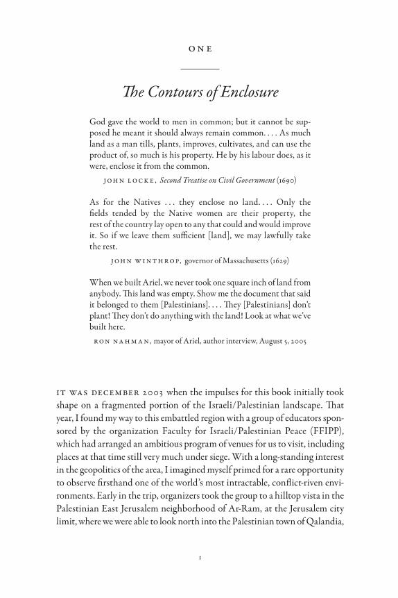
Stationed along the southern perimeter of Qalandia was an elongated concrete wall, its grayish façade of vertically ribbed concrete panels sweeping aggressively across the landscape, partially concealing the building faces on the town’s southern edge (fi g. 1). I was familiar with the barrier because it had become something of a news story, though few images of it—even to this day—appeared in the mainstream media. While I had been to the Berlin Wall when it was still standing, I had never encountered such unmitigated power conveyed so forcefully in the built environment. During the rest of the trip, as the group witnessed similarly partitioned landscapes in Tulkarem and Abu Dis, I was continually taken aback by the intensity of these deliberately fractured environments. Th ese landscapes are the foundation for the central theme in this book: enclosure.
From the very beginning, my impulse for this exploration of enclosure has been comparative. Th e landscapes I observed in the Palestinian West Bank had a compelling echo in the similarly imposing, walled borderland environ-ment of San Diego/Tijuana, close to where I live and work. With this com-parison as a starting point, my early fi eldwork combined several visits to my immediate border area with a six-week immersion in Israel/Palestine, where my focus was the West Bank Wall and its impacts. On this second trip to Israel/Palestine, however, one of my interviewees would change how I under-
Figure 1. Th e Wall at Qalandia in 2003 as seen from the East Jerusalem neighborhood of Ar-Ram. Photo by author.
T h e Con t ou r s of E nc l os u r e • 3
stood what was occurring in the West Bank landscape. Th is interview was with the mayor of the Palestinian town of Qalqilya, Maa’rouf Zahran.
By 2004, Qalqilya had assumed a somewhat heroic status in the confl ict aft er Israeli authorities encircled it with a concrete wall, giving the town a celebrated if unenviable pedigree as a modern-day ghetto. Aft er an interview of almost two hours, the mayor asked if I could return the following day so he could drive me to certain areas of Qalqilya and point out fi rsthand some of the impacts the Wall had had on the life of the city. I was happy to oblige.
Th e next day, Mayor Zahran showed me where Israeli army bulldozers had come under cover of night to begin the massive construction of the barrier. “We were placed under curfew and could not come out of our houses, but we could hear construction work for the next three days,” he said. “When they lift ed the curfew and we came out to see what they had built, we were shocked.” As we got out of his car and began walking alongside the Wall, the mayor became more impassioned. “Our farmers cannot get to their land,” he insisted. “Th ey have enclosed us.” Th e word enclosed, evoking the economic history of England with its early modern enclosures of land, resonated in my imagination. I knew that the English enclosures had dispossessed small farm-ers and eradicated access to common land across the English countryside.
Refl ecting on the mayor’s metaphor over the next several months, I decided to abandon the work I had already done on the border environment near me, convinced that I had a more meaningful point of entry into what was occurring in Palestine than the walled borderland of San Diego/Tijuana. What I had come to perceive in the partitioned morphology of the Palestinian landscape was a diff erent analytical referent, one with echoes of the dispos-sessed from a more distant historical past.
comparing past and present
Th e meaning of events in the present oft en remains elusive to both the actors participating in them and those writing about them. Although this assessment might seem counterintuitive, perception of events in the moment suff ers from two types of distortion that can compromise judgments about the present day. On the one hand, analysis of current events oft en succumbs to what economic historian Paul David (1991, 317) has vividly described as “presbyopia,” the failure to see events clearly owing to an exaggerated sense of the present as historically unique. When framed in this way, current events become separated from a
4 • T h e Con t ou r s of E nc l os u r e
meaningful relationship to the past. Th e second tendency exhibits the opposite problem by insisting—naively—that history repeats itself. Th is approach sug-gests that human aff airs are an ongoing narrative of repetitive occurrences, with events in the present being explainable by reference to past precedent. While the fi rst view overstates the uniqueness of the moment, the second fl at-tens the human story into an ongoing cyclical pattern, one that fails to heed the insight of historians from Hegel and Marx to Marc Bloch and E. H. Carr that history does not in fact repeat. Instead, history is more akin to verse. It rhymes, rather than repeats, thus revealing parallels in events and outcomes from dif-ferent periods in the past that provide a way of seeing the world at hand.
In the spirit of this metaphor, Enclosure acts as a lens, focusing on past events to uncover the meaning of a phenomenon observable in the world today. While taking inspiration from the pioneers of comparative historical methodology (Ibn Khaldun 1381), it also draws insight from modern practi-tioners of comparative history (Skocpol 1984, 2003; Tilly 1984). Substantively, however, this study places landscape at the center of comparative analysis in order to tell a story about power and confl ict over rights to land.
Enclosure reveals how a historically recurrent pattern of power manifested in diff erent geographical places has shaped the fragmented and partitioned landscape visible in Palestine today. To support this claim, this study revisits the territorial landscapes of two earlier historical periods: the early modern enclosures of England and the Anglo-American colonial frontier. Th e funda-mental question posed in the comparison of these three cases is:
How does landscape become the site of confrontation between groups with territorial ambitions and indigenous groups seeking to protect their rights to land, and how do these encounters reshape the landscape to refl ect the out-comes of power, resistance, and dispossession that emerge as a consequence?
Using historical comparison to address this question, Enclosure argues that the Palestinian landscape is part of an enduring narrative of realloca-tions in property rights in which groups with territorial ambitions gain control of land owned or used by others (Banner 2002, S360). Th is narrative reveals how across time and territory, groups coveting land partake of the landscape in a similar way. Th ey use force to dispossess groups already there, justifying their ascendancy as the landscape’s new sovereigns by referencing their capacity to modernize life on the land (Day 2008; LeVine 2005, 15–27).
Infl uenced by a discourse from early modern England about the virtues of “land improvement,” such groups seeking a route to modernity come to
T h e Con t ou r s of E nc l os u r e • 5
imagine a modern order in terms of a changeover in the system of land ten-ure. Th is discourse suggested to would-be modernizers that land improve-ment leading to progress in the human condition was contingent on assign-ing individual rights of ownership to plots of ground, a departure from prevailing notions of the ground as a repository of use rights. While improv-ing land conferred rights of ownership upon the improver, it was the owner-ship of land that provided incentive to those with ambition to initiate improvements in the fi rst place. In this way, rights to land and improving land became inextricably linked on the path to modern progress.
By the early sixteenth century in England, the notion of owning land as a catalyst for improving it and a reward for the improver gathered momentum and inspired conversions of unimproved “waste” land into property. In such conversions, the improver became vested with the most basic right of property, the right of exclusion. Such a right, in turn, entitled the landowner to exclude nonowners from the land as trespassers.
What emerged from this discourse was a rationale for improving unim-proved waste land along with a justifi cation for creating exclusionary spaces on the English landscape. Moreover, once established in England, this dis-course found its way to England’s overseas colonies where it legitimized the colonial impulse to take possession of supposedly unimproved Amerindian land. Eventually this discourse migrated to more distant areas such as Palestine, where Zionists echoed the same themes about modernization and land improvement in justifying their own takeover of Palestinian land and the creation of Jewish spaces on the Palestinian landscape. Th us, the establish-ment of exclusionary Jewish spaces on the Palestinian landscape is part of the same lineage that converted common land in England to private property and Amerindian land to white property. All three cases refl ect the same basic attribute of exclusivity established from a changeover in the system of land tenure, in which the land’s new owners rationalized their takeover of territo-rial landscapes by insisting on their unique capabilities to modernize and improve the land.
Starting from this imagined vision, modernizers enlist three critical instruments—maps, property law, and landscape architecture—to gain con-trol of land from existing landholders and remake life on the landscape con-sistent with their modernizing aims. Such transfers of land and changes in systems of landed property rights became inscribed into the land surface through the remaking of boundaries on landscapes. Th is practice of bound-ing the land defi nes “spaces of belonging” where people can live, work, and
6 • T h e Con t ou r s of E nc l os u r e
circulate. In reordering boundaries on the land, groups with modernizing aspirations and territorial ambitions set aside ever larger areas for themselves while diminishing and even eradicating spaces of belonging for the dispos-sessed. Th is process of overturning rights to land in which land passes from one group of landholders to another, and of remaking boundaries on the landscape to match this change in land ownership and use, is referred to in this study as the phenomenon of enclosure.
Enclosure is a practice resulting in the transfer of land from one group of people to another and the establishment of exclusionary spaces on territorial landscapes. At the same time, enclosure brings profound material changes to the land surface aft er the practitioners of enclosure replace the disinherited as sovereigns and stewards on the land and begin to construct an entirely diff erent culture on the landscape. Equally far-reaching are enclosure’s impacts in redistributing people to diff erent locations. Th ose redrawing boundaries on the land designate the enclosed areas as spaces of belonging for the promoters of enclosure, while those displaced by enclosure are driven into ever-diminishing territorial spaces, their presence on the landscape now con-sidered trespass subject to removal. One trenchant description of this process reveals how it resulted in the “clearing” of the landscape and the “sweeping” of people from the land (Marx 1867, 681).
Enclosure argues that the Palestinian landscape is part of this lineage of dispossession and that this lineage of establishing exclusionary territorial spaces on the land surface is traceable to the practice of overturning systems of rights to land stemming from the enclosures in early modern England. By the early seventeenth century, this pattern of dispossession and the creation of exclusionary landscapes had migrated from England to its North American colonies. And today, it is found on the landscapes of dispossession in Palestine/Israel. By drawing on historical comparison to reveal this recurrent pattern of enclosure on land, this book aims to uncover meanings in the Palestinian landscape not otherwise knowable from direct observation in the present alone.
theorizing landscape
In the formal language of research, the three case studies of enclosure and dispossession in this book form a unifi ed story focusing on the interplay of two primary variables, the independent variable of power and the dependent
T h e Con t ou r s of E nc l os u r e • 7
variable of landscape. In thus aligning power and landscape, Enclosure draws from the broad theoretical insight of Foucault (1984, 252) about power as a fundamentally spatial phenomenon and, conversely, the geographical notion of landscape as “power materialized” (Philo 2011, 165; Mitchell 2012, 397). Enclosure tracks the variation in the landscape across the three cases when dominant groups coveting territory use their power to seize control of land in an eff ort to modernize patterns of development in a place. In this way, Enclosure contributes empirical insights to one of the defi ning theoretical issues in human geography—how power shapes and remakes the space of territorial landscapes (Mitchell 2002). What results when power is applied to the landscape and control of land passes from one group to another is the focus of this study: enclosure landscapes.
As a theoretical concept, “landscape” has two basic attributes. In the fi rst place, landscapes have materiality corresponding to the morphology of the land surface that is created by the interplay of the “natural” environment and human activity. In this sense, landscapes emerge from the way the land sur-face anchors human populations and the systems of cultivation, the patterns of economy and culture, and the architectural forms sustaining human pres-ence (Baker 2003, 78). Such a perspective derives from the work of Carl Sauer, who viewed the landscape as a cultural phenomenon in which human activity is the agent, the natural environment the medium, and the cultural landscape the outcome (Sauer 1925, 343). From this perspective, landscapes are socially constructed territorial spaces that possess a material reality cor-responding to what “the eye can comprehend at a glance” (Jackson 1984, 3).
Such morphological contours imbue landscapes with the attributes of texts that convey meanings about the life processes occurring on the land surface. Just as books communicate through words, landscapes communicate through the contours of land. While there is not always a directly perceivable route from the material landscape to human life processes in a place, the land surface is nevertheless a starting point for reading land as a document that refl ects meanings about the society and human activity anchored to it (Widgren 2006, 57; Mitchell 2000, 113).
Landscapes also convey meanings about the societies anchored to them on the basis of viewers’ interpretations of what they are observing (Said 2000; Cosgrove 2006, 50; Schein 1997, 664). Th us, the landscape is not limited to “what lies before our eyes”; it also comprises “what lies in our heads” (Meinig 1979, 34). From this perspective, landscapes are still texts, but now they are open-ended documents in which viewers imbue land surfaces with meaning.
8 • T h e Con t ou r s of E nc l os u r e
By this process of perception, landscapes transition from refl ections of soci-ety to sources of projection and imagination.
From this foundation of landscape as both material and representational, the land surface becomes understandable along a continuum (Braverman 2009a, 8–9). On one end of this continuum is the morphological concept of land in which land assumes strictly material attributes. On the other end is the subjective and representational idea of land in which human actors imag-ine and project meaning onto the land surface. Enclosure draws upon both notions in seeking to uncover the interplay of landscape and power.
Once imbued with meaning stemming from human imagination, land-scapes are open to change from human action. Just as human actors reshape society according to their ideas about the world, so too do they remake the landscape in terms of how they understand and imagine it. Th is notion of landscape as a socially constructed outcome of human imagination and human activity is best described by a geographical concept that lies at the center of Enclosure, “territoriality.”
Territoriality refers to the eff orts of individuals or groups to shape pat-terns of development in a place by “asserting control over a geographic area” (Sack 1986, 19). From this premise, territoriality reserves a role for landscapes as outcomes of power and human agency (Mukerji 1997, 2). At the same time, territoriality elevates landscapes as instruments of power in which human action manipulates the land surface to remake the very life processes that are anchored to it (Weizman 2007).
Two sets of literature provide theoretical foundations in Enclosure for con-necting landscape to power and building an argument about the recurrent pattern of power inscribed into territorial space to enclose and seize control of land. Th e fi rst set of literature examines the role of human imagination—imaginative geography—as a source of power motivating human actions to remake landscapes. Th e second explores maps, law, and landscape architec-ture as “technologies of force” for transforming land.
Imaginative Geography
Th e inspiration for the fi rst set of literature derives from Edward Said (1978, 1993, 2000), who craft ed a theoretical explanation of how groups with territo-rial ambitions come to take possession of land belonging to others. Land hun-ger, Said insists, following Marx, ultimately derives from material impulses. “To colonize distant places,” he writes, “to populate or depopulate them: all
T h e Con t ou r s of E nc l os u r e • 9
of this occurs on, about, or because of land” (Said 1993, 78). Yet the seizure of land, he argues, following insights from fi gures such as Max Weber, Antonio Gramsci, and E. P. Th ompson, results from a discursive outlook on the part of actors coveting the land.1 For Said, groups with a hunger for land essentially reimagine the landscapes they desire, elevating notions of themselves as the owners of the land they seek. Said (2000) described this process of reinventing the meaning of territorial landscapes as “imaginative geography.”
As a process of refashioning the meaning of territorial landscapes, imagi-native geography enables groups with land hunger to frame arguments justi-fying why they are entitled to take possession of the landscapes they desire. At the same time, those with land hunger do not respond mechanically to the material incentives for seizing land. Instead, these actors come to a new discursive understanding of themselves as owners of the landscapes they covet, as a prelude to seizing them. Consequently, Said’s imaginative geogra-phy is a theory of human action deriving from the interplay of material impulses and human consciousness (Gregory 1995). In this sense, Said’s imaginative geography is “performative.” Reimagining landscapes is but a fi rst step to acting upon them and creating the very outcomes on the land being imagined (Gregory 2004, 17–20). In this process of reimagining geog-raphy, groups with territorial ambitions refashion themselves as owners of the territory they desire by projecting themselves as masters and sovereigns of the land.
Technologies of Force
Technologies of force refer to the actual instruments used to enclose and seize control of land. Th ree instruments are decisive in this process of enclo-sure and dispossession.
Th e fi rst instrument is cartographic, focusing on the power of maps to craft “arguments” about the territories they represent (Harley 1989). As arguments, maps convey a point of view about territory. What gives carto-graphic representation its power as an instrument of force is thus similar to the way arguments shape individual and collective thinking and inspire indi-vidual and collective action. Readers of texts oft en see the world diff erently as a result of arguments, and they then act to change it in accordance with what they see. Maps emerge as instruments of force and change by (re)shap-ing consciousness about the land among map viewers, some of whom act upon territory to bring it into conformity with the way they see it and

10 • T h e Con t ou r s of E nc l os u r e
understand it. In this way, maps become models for rather than models of what they supposedly represent (Winichakul 1994, 130). Mapmakers craft these projections about territory through certain formal techniques that include choosing where on maps to place boundary lines; giving places on maps certain names or even renaming places with new toponyms; and signal-ing specifi c meanings about territory through map titles and iconographic cartoons known as “cartouches.” As artifacts of how groups seeking territory project meanings about land, maps become instruments for putting imag-ined visions of landscape onto the ground itself.
Th e second instrument used to enclose and take possession of land is legal, focusing on the use of the law, specifi cally property law, as well as courts and legislation to remake landscapes in the image of what is imagined and pro-jected onto maps. At the core of legal power lies the state as the institution of legitimate force and domination. Groups coveting land enlist the lawmaking power of the state to reconfi gure geographical landscapes according to their reimaginings, with themselves as the new owners and sovereigns on the land. In pursuit of such imagined territorial visions, groups with land hunger use the law as a weapon, reassigning the ownership status of spaces on the land and elevating themselves as the land’s new dominant owners. As the latter leverage the law to transfer land possessed and used by other groups to them-selves, they enlarge and reinforce spaces of exclusion and trespass for the dis-inherited, restricting where the dispossessed can live and circulate. At the same time, the law reinforces cultural routes to remaking landscapes when actors enlist the state to rename geographical places, thus helping to bring landscapes into conformity with the way they have been reimagined (Benvenisti 2000, 11–54). Th e use of law as a coercive technology to codify and legitimize the transfer of land from one group to another, and the use of law to remake the landscape itself has been aptly described as “lawfare” (Blomley 2003, 128; Comaroff 2001, 306; Harris 2004, 179; Hajjar 2017).
Th e fi nal instrument is architectural and refers to changes in landscapes engineered by groups seeking to enclose land. Upon reimagining and over-turning systems of rights to land, practitioners of enclosure anchor them-selves more fi rmly to the landscape by rebuilding it, craft ing material envi-ronments that convey their ascendancy on the land while erasing the built forms and cultural markers of groups once dominant on the land. Th us, the landscape is both an outcome and a process (Mitchell 2002, 1). Th is process of enlisting the landscape as an instrument of domination enables groups seeking territory to align the material landscape with the landscape they have
T h e Con t ou r s of E nc l os u r e • 11
imagined in maps and realized through the law. It is part of an off ensive program to seize control of land in the making of modernity.
From these foundations, what remains an empirical question is the source for the imagined visions of coveted landscapes among groups with territorial ambitions, and the way that these groups used the technologies of force avail-able to them for enclosing and seizing control of coveted land.
enclosure across three cases
With comparison as a method, and with landscapes theorized as socially constructed outcomes of power imprinted on land, this study develops an argument about the enduring process of enclosing land as a platform for modernizing development in a place. Spearheading this process are domi-nant elites who lay claim to land in order to establish a territorial foundation for their modernizing aspirations. Such groups essentially reimagine them-selves as sovereigns on the land they covet for their modernizing aims and enclose the landscape as the path to progress. Enclosure tells how the reorder-ing of landscape became a critical part of modernity, and how the remapping of and boundary-making on landscapes conformed to the modernizing impulses and territorial ambitions of English estate owners, Anglo-American colonists, and Israeli Zionists alike.
Imagined Geographies of Improvement
What ignites the passions of groups with modernizing aims and territorial ambitions to enclose and take possession of land is an enduring discourse about the virtues of improving land. As a discourse, land improvement pro-moted an imagined vision of the landscape in which land lying empty could be improved and thus redeemed by those willing to work it. Th e latter, in turn, would be rewarded for their eff orts by gaining rights to land where they invested their labor. While the early Islamic world embraced aspects of this idea (see chapter 6), land improvement has roots in sixteenth-century England. For promoters of this discourse, improved land could be identifi ed by two attributes: it was cultivated, and it was enclosed by fences, walls, or hedges built by the cultivator (McRae 1996, 136–37). Th rough the practices of cultivation and enclosure, advocates of land improvement sought to rem-edy the waste of barren land by endowing those willing to cultivate, enclose,
12 • T h e Con t ou r s of E nc l os u r e
and improve such land with a proprietary right to it (Seed 2001, 29–40). Th us, the discourse of land improvement provided its practitioners with an imagined vision of what an improved landscape would be.
As this discourse evolved, its promoters increasingly targeted land used as a common resource as the source of the problem related to empty land (Warde 2011, 128). By the late seventeenth century, John Locke (1690) added a qualifi er to this discourse, suggesting that land “poorly cultivated” was akin to land lying in waste, which he claimed not only violated the Enlightenment spirit of rationality but also contravened the laws of God for humans to sub-due the earth for their subsistence. Accordingly, promoters of land improve-ment were reinventing both the common landscape in early modern England and the indigenous landscape in North America as empty and available for the enterprising cultivator (Horn 1994, 128–29). Similar reinventions of landscape resurfaced later in Zionist ideology, which represented the Palestinian landscape as barren and neglected (Eisenzweig 1981, 282). Graft ed upon these three diff erent historical landscapes, the discourse of land improvement beckoned to new owners.
In England, this imagined geography of improvement infl uenced owners of large estates to reclaim prerogatives over land used by their tenant cultiva-tors as a common resource (Neeson 1993; Th ompson 1991). Seeking to put such land under crop and satisfy a national outcry for increasing agricultural output, estates by the late seventeenth century embarked on a program of extinguishing the rights of tenants to use land collectively, mostly for com-mon grazing—rights codifi ed by early common law statutes and by custom. In addition, estate owners used their fi nancial power to buy out small free-holders and run out the leases of their tenants, thereby taking possession of the non-common land on their estates (Allen 1992, 78). Th ese repossessed lands were then consolidated into large farms and rented to large tenants who hired many of the displaced former cultivators as wage laborers. Th us, from an imagined vision of improvement emerged a “landlord’s revolution” whereby estate owners seized land used by smaller cultivators and remade landscapes with common uses into a series of large-scale units of individual property (Allen 1992).
Not surprisingly, ideas about land improvement that infl uenced the enclo-sure of land in England migrated to England’s North American colonies, where settlers, despite evidence to the contrary, regarded the Amerindian landscape as unimproved and without owners (Horn 1994, 128–29; Marzec
T h e Con t ou r s of E nc l os u r e • 13
2002, 131; Cronon 2003, 130). In the colonial context, this discourse framed an imagined landscape in which Amerindians failed to use land effi ciently and whose entitlement to land was thus rightly subordinated to those willing to work the land with plows, as God and reason had intended. Establishing colo-nial dominion on Amerindian land was thus an extension of the improvement outlook emerging ascendant in seventeenth-century England (Edwards 2005, 219, 222). By the time these colonists emerged victorious in the War of Independence, ideologues for the fl edgling nation had succeeded in fusing the English colonial notion of unimproved Amerindian land with a newer idea of a teleological, if not divine, mission of settling North America and civilizing the entire continent through the colonization and improvement of Amerindian land (Ostler 2004, 12–13; Miller 2006, 130). As in England, a discourse about improving land inspired an imagined geography of Amerindian dispossession and English settlement of the Native landscape.
In Palestine, inspiration for enclosing the landscape derived from the idea of a state homeland for the Jewish people popularized by the early Zionist movement, but what made Palestine especially appealing for this project were long-standing Jewish perceptions of the area as underdeveloped, which Zionists exploited in representing themselves as modernizers destined to improve what had been left in waste (LeVine 2005, 23–24). In justifying Palestine as the ideal location for building a Jewish state, Herzl and early Zionists drew on the spirit of Locke in describing the area as poorly culti-vated by Palestinian farmers, beckoning to be improved by Zionist coloniza-tion (Braverman 2009a, 76). “Our country, . . . has remained desolate,” insisted Aaron David Gordon, “poorer than other civilized countries and empty—this is confi rmation of our right to the land” (quoted in Zerubavel 2008, 205). In this way, Zionists invented a Palestinian geography of barren land awaiting Jewish labor to take possession of it, modernize it, and improve it (Eisenzweig 1981). From this imagined geography, Zionists found a ration-ale for taking control of the Palestinian landscape and refashioning it to conform to their invented notions of what it was, and what it should be.
In all three cases, improvement was the basis of an ideology justifying the seizure of land as a route to creating a modern order on the landscape. In each case, groups promoting this route were constrained by existing systems of land ownership and sovereignty. Enclosure is what aff orded groups with ter-ritorial ambitions and modernizing aspirations a pathway through these constraints.
14 • T h e Con t ou r s of E nc l os u r e
Technologies of Force
Once imbued with visions of an improved landscape, promoters of enclosure use the three basic instruments—maps, law, and landscape architecture—as technologies of force to enclose and take possession of coveted land.
In England, the use of maps for enclosing land began as part of a “carto-graphic revolution” in the late sixteenth century marked by the advent of a more graphic means of representing land on estates (Harvey 1993a, 15–17). Two key actor groups spearheaded this revolution: the estate owner inspired by the idea of improvement, who wanted a picture of how land on the estate could be enclosed and improved; and the surveyor/mapmaker, who provided estates with a graphic picture of how this aim could be fulfi lled. From this alliance emerged estate mapping that revealed to estate owners how their various lands, encumbered with common rights and the complexities of dif-ferentiated tenures, could be remade into an improved, economically rational and propertied landscape. Cartography, in eff ect, provided a new way of see-ing land on the manor—“knowing one’s own”—that enabled estate owners to imagine how to enclose and take possession of certain lands in order to improve and profi t from them (McCrae 1993).
In North America, cartography was also creating imagined visions of the landscape. Much in the same way that estate maps were suggesting to English landowners how to consolidate freeholds and tenancies and take control of common land, early English maps of North America, such as the 1616 map of New England by John Smith, projected notions of a territorial vacuum domi-cilium and an imagined Anglicized geography onto the landscapes of the New World (Harley 2001). Later, mapmakers such as Th omas Holme (in 1687), John Mitchell (in 1755), and John Melish (in 1816) extended this idea of emptiness by representing “improved” territorial landscapes in North America in which Amerindians were largely absent and orderly grids of prop-erty lines stretched unencumbered toward the west. In this way, Anglo-American maps of colonial America provided visual testimony to how Native land was reimagined as a Euro-American landscape demarcated by property boundaries and lines of colonial sovereignty (Boelhower 1988, 478).
Like estate owners in England and colonists in North America, Zionists drew upon cartographic representation to promote a national imagination about Palestine as Jewish land (Newman 2001, 239–40; Leuenberger and Schnell 2010, 807). During the 1920s and 1930s, the Zionist movement, through the Jewish National Fund (JNF), sought to popularize the idea of
T h e Con t ou r s of E nc l os u r e • 15
Palestine as a Hebrew territorial space and to this end commissioned a series of maps representing Palestine as an area of Jewish settlement absent an Arab presence (Bar-Gal 2003, 139–51). In 1934, the JNF deployed one of these maps on its celebrated “Blue Box,” used to collect money for the purchase of land and the promotion of Jewish settlement in Palestine. In conveying a message to its own constituents and the world at large, the map on the Blue Box car-ried two critical arguments about how Zionists imagined the Palestinian landscape. First, the map, through omission, concealed Palestinian geo-graphical places, rendering Palestinians as absentees on the land where they lived. Second, with its title, Eretz Yisrael, the map conveyed an unmistakable message to Jews and non-Jews alike about the land of Palestine as Hebrew space and the patrimony of the Jewish people (Bar-Gal 2003, 137).
Aft er the emergence of the state of Israel in 1948, cartographic projection of a Hebrew landscape on the territory of the new state continued, focused more decisively on toponymy as Arabic place-names were replaced with Hebrew names (Benvenisti 2000, 11–54; Cohen and Kliot 1981). Th e critical moment in this process occurred in 1949 when Israel’s fi rst prime minister, David Ben-Gurion, established an offi cial “Place-Names Commission,” charged with cre-ating a Hebrew toponymy for the country’s geographical features and places. Th e culmination of the commission’s work was a Hebrew map of the territory now offi cially known as the State of Israel. Th is map marked the cartographic “hebraicization” of a landscape formerly represented by a system of place-names that refl ected the once-dominant Arabic-speaking culture of Palestinians, who had become a people dispossessed (Falah 1996; Benvenisti 2000, 11–54). Th e new state used, and continues to use, this map with its Hebrew place-names to reinforce the idea of Jewish ascendancy on this land.
Th e second instrument, lawfare, played a decisive role in transcribing these cartographic visions into a set of laws for ordering rights of land owner-ship, use, and access on the landscape.
In England, enclosure was in the fi rst instance a legal process of turning land encumbered with common uses to severalty (Whyte 2003, 9). While historically legal institutions such as common law, manor courts, and even Crown Courts had protected the rights of English tenant farmers to com-mon land, by the mid-seventeenth century public support for enclosure as promoted by improvement writers emboldened estate owners to initiate a comprehensive legal challenge to such rights (Reid 1995, 245; Allen 1992, 95, 104). Th is legal revolution against rights of commons, in turn, was the prel-ude to remaking the English landscape when enclosure occurred through a
16 • T h e Con t ou r s of E nc l os u r e
very specifi c institution—acts of Parliament. Numbering in the thousands, Parliamentary Enclosure Acts provided estate owners with a fi nal set of legal tools for extinguishing virtually all remaining common rights to land by the late eighteenth century, enabling those areas of the landscape once reserved for common uses to come under control of large estates (Allen 1992).
In the United States, lawfare as an instrument of dispossession is best exemplifi ed by two legal landmarks of the early nineteenth century. Th e fi rst was the Supreme Court decision Johnson v. M’Intosh (1823), one of the defi n-ing cases in American legal history which abrogated Amerindian rights to land (Banner 2005; Robertson 2005). In its decision, the Supreme Court remade Native Americans into “tenants-at-will,” affi rming that in the terri-tory of the United States Amerindians did not possess rights to the land they occupied and used. Th e second was the Indian Removal Act (1830), signed into law by President Andrew Jackson. Th is law empowered the U.S. govern-ment to clear land in the East of Indian “tenants” and set this land aside for settlement by white American colonists.
In Palestine, the state of Israel that emerged victorious in the confl ict with the Palestinian community invoked a series of legal measures enabling the new state to gain control of Palestinian land and reallocate it for new Jewish settle-ments (Forman and Kedar 2004). Th e decisive legal mechanism in this process was the creation of state land from land formerly possessed and used by Palestinians. Th is legal designation enabled the government of Israel to transfer almost the entire land surface of the new state into state ownership. On this legal foundation, hundreds of new Jewish settlements were built within present-day Israel, refl ecting the realization of an imagined vision evolving among Jews for decades of Palestine as a Jewish territory. Moreover, this legal instrument of creating state land from Palestinian property continues to be used in Occupied Palestine as a means of transferring land from Palestinians to the Jewish state and ultimately to Jewish owners (Forman 2009).
Th e fi nal instrument, landscape architecture, is the outcome of carto-graphic visions and legal inscriptions on the land, but it is also a technology for changing the material and symbolic character of the landscape itself.
In England, what proliferated on the landscape from enclosure was the large-scale “rent-maximizing farm” that spearheaded the transformation of the countryside into a more geometrically regularized pattern of privately owned spaces (Allen 1992). Th is institutionally driven architectural change, in turn, reshaped the rural landscape with untold miles of stone walls, fences, and hedgerows, built by those enclosing the land not only to demarcate their
T h e Con t ou r s of E nc l os u r e • 17
newly enlarged holdings (Rackham 1986, 190–91) but also to close rights of way and restrict access to what had been an agricultural system of open fi elds allowing free movement and use of certain lands as a common resource (Blomley 2007; J. Anderson 2007). Emerging from these institutional and architectural changes in the English countryside was a landscape unrecogniz-able compared to what it had been prior to the wholesale enclosure of land (Bermingham 1986, 9; Hoskins 1977, 178).
In the United States, what emerged as an institution of dispossession driv-ing change on the landscape was the self-contained settler homestead, which, as improvement gained ascendancy, replaced an earlier colonial settlement pattern of nucleated villages similar to the open common fi eld villages of England (Greven 1970, 50–53). Created from a felled tract of wilderness and demarcated by a fence, the settler homestead anchored the colonial idea of an improved and civilized landscape (Williams 1992, 53–73; Cronon 2003, 128, 159–70). In graft ing this imagined vision of improvement onto the land, Anglo-American settlers inscribed the landscape with a radically linear order represented by individually owned plots of ground and “seemingly endless miles of fences.” In so doing, they established a landscape of trespass marked by an ever-expanding grid of territorial spaces that were increasingly off -limits to Amerindians. As this landscape swept across the continent, it spawned another institution of dispossession that acted as a repository for the dispossessed: the Indian reservation.
In Palestine, the institution proliferating across the landscape with similar eff ect is the Jewish settlement. From the beginning of Zionist-inspired Jewish immigration to Palestine in the late nineteenth century, the newcomers sought to expand their presence on the Palestinian landscape by building settlements, easily distinguished by their geometrically ordered contours. Aft er the Jewish community in Palestine—the Yishuv—prevailed in a con-fl ict with the Palestinians in 1948–49 and assumed sovereignty over territory covering 78 percent of Palestine, now renamed the State of Israel, the state’s new sovereigns embarked on a massive settlement-building program. Roughly seven hundred new Jewish settlements were built on land where close to fi ve hundred Palestinian villages once existed, the former residents suff ering exile and becoming refugees. In the Palestinian Territories occupied by Israel since 1967, the state has established an additional 145 Jewish settlements on land reclassifi ed by the occupying power as Israeli state land, which in many instances belonged to Palestinian residents of villages nearby. What has tran-spired as land ownership has shift ed from one group of people to another is
18 • T h e Con t ou r s of E nc l os u r e
a profound transformation on the landscape. Erased is the Palestinian vil-lage, and in its place is a landscape anchored and dominated by Jewish settle-ments. In 1947, the footprint of land ownership for Jewish settlement in Palestine amounted to roughly 8 percent of the land surface. Today, Jewish settlements and the infrastructure supporting them in both Israel and Occupied Palestine proliferate on roughly 85 percent of what was the Palestinian landscape (Halabi, Turner, and Benvenisti 1985, 4). In this trans-formation, a system of agrarian villages connected to a collective and coop-erative system of land tenure has given way to a landscape of suburban-style communities that mark the transfer of land from one group of people to another (Yift achel 2006; Weizman 2007).
As they expand and proliferate, the rent-maximizing farm, the settler homestead, and the Jewish settlement drive a set of anchors into the land-scape that serve as the foundation for a new system of ownership and sover-eignty and a diff erent pattern of political economy and cultural expression.
“Clearing” the Landscape
One of the enduring outcomes of enclosure is demographic, related to the clearing and transfer of populations from territorial landscapes. Implemented through combinations of compulsion and force, such transfers of people evidenced two dimensions: a change in the location of populations, and a change in their social standing. Invariably, these two processes are interdependent.
In England, enclosure transferred small cultivators socially from agrarian activities on the land anchored by common rights, to activities on the land connected to their new status as wage earners in both agriculture and emerg-ing rural industries. As the impacts of enclosure intensifi ed, especially aft er the eighteenth century, and as many cultivators were dispossessed of land entirely, they migrated from their rural origins, reemerging in diff erent loca-tions as wage workers in a newly ascendant urban environment. In eff ect, as spaces of private individual property spread across the English landscape and as spaces of common property disappeared, cultivators once able to use land as a common resource assumed a new identity and were cleared from the land-scape, driven into diff erent geographical locales in order to earn a living.
In the United States, enclosing the landscape provided the basis for a change in the social status of Amerindians, who by the beginning of the nine-teenth century had been reclassifi ed as “tenants-at-will.” Th is change in turn
T h e Con t ou r s of E nc l os u r e • 19
enabled the U.S. government, pressured by land-hungry settlers, to remove Indians from locations where they had existed, a policy institutionalized in the Indian Removal Act of 1830. Once uprooted legally, Amerindians were driven into more spatially confi ned reservations, where they assumed a new social status as discriminated-against, if not forgotten, second-class citizens.
In Palestine, enclosure forcibly transferred Palestinians from areas of present-day Israel to outlying foreign territories or into the West Bank and Gaza Strip, where they assumed a new social status as refugees. Palestinians remaining in what emerged as Israel, in turn, have been systematically dispos-sessed and confi ned to ever-shrinking territorial landscapes stemming from the expansion of Jewish settlement onto land that once belonged to them, an expansion and dispossession enabled by new property laws. Th eir land thus taken both by law and by the Jewish settlements that followed, Palestinians inside Israel have been transferred socially from agrarian activities into earn-ing wages, primarily in construction, building—ironically—new Jewish towns and settlements (Shafi r and Peled 2002, 112–25). In areas of Palestine under Israeli military rule, Palestinians are being dispossessed by an ever-expanding footprint of Israeli settlement-building, which makes areas of the landscape once used by Palestinians now off -limits to them. In this manner, Palestinians are physically moved into ever more confi ned territorial spaces, while socially they are relegated to the status of the permanently unemployed and impoverished.
Although unequal power enables dominant groups with territorial ambi-tions to enclose land, power is not absolute in these encounters but is woven into contingent relationships with the less powerful, setting in motion cycles of domination and resistance (Braddock and Walter 2000; Calloway 2003; Khalidi 1997). In this regard, indigenous groups are historical actors seeking to negotiate the conditions of their existence vis-à-vis those in power. Such groups, when facing enclosure that aims to dislodge them from the land-scape, inevitably resist. Th us, enclosure landscapes are part of a long-standing narrative about power, resistance, and place in which both dominant and subordinate actors create outcomes on the land.
plan view of enclosure
Enclosure is a history of power and space. Its aim is to reveal the landscape outcomes when groups with modernizing aspirations and territorial ambi-
20 • T h e Con t ou r s of E nc l os u r e
tions use force to dislodge other groups from their land. In narrating parallel stories about power and space, Enclosure is unique in two fundamental ways, one methodological, the second theoretical.
Methodologically, there is no book-length work that situates the Palestinian landscape within the comparative frame developed in this study. To be sure, references to colonization and settlement exist in the literature on the Israeli/Palestinian confl ict, which in turn allow comparisons to be made between the dispossession of the Palestinians and that of other colonized groups (e.g., Shafi r 1996; LeVine 2005; Yift achel 2006; Makdisi 2008; Hanafi 2009, 2013). Yet no studies link events on the Palestinian landscape to the long-standing discourse about land improvement with origins in English common law and rights to landed property.
From this comparative foundation, Enclosure makes two important theo-retical contributions to spatial history. First, in focusing on the enduring narrative of land improvement and dispossession in England, America, and Palestine/Israel, Enclosure gives empirical life to one of the most impor-tant theoretical concepts in geography studies: the interplay of power and territorial space. Second, in revealing how groups with territorial ambitions come to reimagine land, the book constructs an empirical account of one of the most salient theoretical notions in cultural geography, the notion of imaginative geography, providing a potent example of how Edward Said’s insight can be applied to dispossession in actual historical settings. Together, these two theoretical notions—the interplay of power and space, and the workings of imaginative geography—create the outlines of the model that runs throughout the book, a model describing the transfer of land from one group to another and the resulting physical transformation of landscapes.
In addition to method and theory, the argument in this book about the recurrent pattern of enclosure and dispossession reveals a unique set of politi-cal ramifi cations that remain relevant today.
Enclosure steps into a highly charged debate about the nature of the con-fl ict in Israel/Palestine. While Israeli practitioners of enclosure in Palestine seek to deny that seizures of Palestinian land play any role in the confl ict, parallels with dispossession in the English enclosures and the dispossession of Native Americans suggest otherwise. Indeed, Enclosure challenges the idea of the uniquely beleaguered nature of Israeli society as the motivation for the seizure and remaking of Palestinian land. Inspired by an enduring ideology of land improvement, Zionist settlers and their modern-day descendants

T h e Con t ou r s of E nc l os u r e • 21
have acted in much the same way as other groups with power toward the less powerful, when the latter become an obstacle to the territorial aims of the former. Like previous historical examples of groups with territorial ambitions and modernizing aspirations, Zionists have seized and remade territory at the expense of a group of people already on the land. Th ere is, in eff ect, a parallel story about power embedded in the landscapes of the English enclosures, the Anglo-American colonial frontier, and Palestine today. All three of these cases are spatial projects, in that they revolve fundamentally around the con-trol of land.2 All three cases reveal actor groups inspired by visions of land improvement who reimagine and remake territory using similar instruments that allow them to enclose and take control of landscapes while elevating themselves to positions of sovereignty on the land.
Th ese groups with power and land hunger, however, do not achieve their territorial aims uncontested in some grand teleological march. In each case, those enclosing land encounter resistance, in which the barriers they place on the landscape—fences, hedges, and walls— to seize control of territory and impede the mobility of the dispossessed come to serve as specifi c targets of systematic opposition. In this way, the enclosure of landscape, and resistance to enclosure are integrated in an enduring and contingent narrative shaping the contours of the modern world (Linebaugh 2010, 11).
Enclosure tells this story of domination and dispossession in three parts, focusing in turn on the English enclosures, Amerindian dispossession, and Palestinian land loss. Each part consists of two chapters: fi rst, in chapters 2, 4, and 6, we look at previously existing patterns of landholding on the part of English commoners, Amerindians, and Palestinians; then, in chapters 3, 5, and 7, we see how estate owners, Anglo-American settlers, and Zionists, inspired by discourses of land improvement and using similar instruments of power, overturned existing systems of landholding and seized control of land, installing themselves as owners and stewards on the landscape. Th ese chap-ters are broadly symmetrical in outlining the imagined geography of improve-ment in each case and showing how maps, the law, and landscape architecture transformed what was imagined into actual systems of dispossession. Chapter 7, dealing with the Palestinian case, is also informed by a second critical method, one that complements the historical comparison running through-out Enclosure. Portions of this chapter rely on what ethnographers refer to as “participant observation,” in which the researcher “participates” to varying degrees in the social environment being studied (Fields 2016, 256). As a prac-tical matter, this chapter utilizes data generated from interviews with both
22 • T h e Con t ou r s of E nc l os u r e
Israeli and Palestinian actors. Finally, chapter 8 summarizes common themes across the three cases in supporting the claim of Palestinian dispossession as part of a recurrent pattern of reallocations in rights to land.
Although “landscape” is the focus of this study, human subjects are what animate the story told in this book about land. Enclosure shows how a dis-course about improving land reshaped the mindset of human actors in dif-ferent places and diff erent time periods, and how this discourse, despite those diff erences, assumed similar attributes in the landscape. In the end, Enclosure is a story of how ideas act as change agents and become part of the land-scape—but it is human actors who put new thinking into the land. What follows is a tour of these parallel stories about discourse, power, and land aimed at gaining insight into one of the most contested geographical land-scapes of present day.