th meeting of the reconstituted committee of the … minutes...the project proponent (pp) that...
TRANSCRIPT
Page 1 of 74
MINISTRY OF ENVIRONMENT & FORESTS
(IA DIVISION)
******
SUMMARY RECORD OF 11th MEETING OF THE RECONSTITUTED
COMMITTEE OF THE EXPERT APPRAISAL COMMITTEE FOR
ENVIRONMENTAL APPRAISAL OF MINING PROJECTS CONSTITUTED
UNDER EIA NOTIFICATION, 2006.
The 11th Meeting of the Reconstituted Expert Appraisal Committee for Environmental Appraisal of Mining Projects (Non-Coal) of the Ministry of Environment and Forests was held during 25th - 27th September, 2013. The list of participants is annexed. After welcoming the Committee Members, discussion on each of the Agenda Items was taken up ad-seriatim. Item No. 1:
1.1 Confirmation of the minutes of the 10th EAC Meeting.
The Minutes of the 10th Meeting of EAC held during August 21st-23rd, 2013 were confirmed as circulated.
Agenda Item No. 2:
2.1 Quartz & Feldspar Mine of M/s Ravi Seelamsetty located at village
Bandivankacharla, Taluka Kulkcherla in District Rangareddy in Andhra
Pradesh. (ML area-56.68ha and production capacity: 3.0 Lakh Tonnes
per Annum of Quartz) (Consultant: Bhagavathi Ana Labs Ltd.,
Hyderabad)- Environmental Clearance.
The proposal is for production of 3.0 Lakh TPA quartz from Quartz &
Feldspar Mine sy no 415(P) with 56.68 ha mine lease area of M/s Shri Seelamsetty Ravi Chandra. The mine lease is located in Bandivankacharla village, Kulkcherla Taluka, Rangareddy District, Andhra Pradesh. The coordinates of the mine lease area are as follows:
A. 17°02′41.41″N & 77°49′19.38″E B. 17°02′45.83″ N & 77°49′29.33″E C. 17°01′50.01″ N & 77°49′22.73″E D. 17°01′51.61″ N & 77°49′30.88″E
The proposal was considered by the Expert Appraisal Committee in its
meeting held during 25-26th February, 2010 to determine the Terms of
Page 2 of 74
Reference (TOR) for undertaking detailed EIA study. The TORs were issued by MoEF vide letter no. J-11015/05/2010-IA.II (M) dated 9th March, 2010.
The mine lease area is 56.68 ha (Govt. Non forest land). It is reported by the Project Proponent (PP) that mining will be carried out by opencast mechanised method of mining with 115 mm dia DTH drilling and controlled blasting. The interstitial waste is directly loaded into tippers and transported to the reject dump yard. In the ore zone, the ore will be directly loaded in the tippers and dispatched to the designated places. The water requirement is estimated as 14.0 kld, which will be obtained from ground water. It was reported by the PP that the mining will not intersect ground water table in the area.
It is reported by the PP that Total Geological Reserves are 59,82,786 Tonnes as per approved mining scheme. The anticipated life of the mine is 23 years. The height of mine bench will be 3m and the width will be more than 6m. Drilling and blasting will be carried out in the mine. Compressed air operated DTH drilling machine will be used for drilling holes. Controlled blasting using NONEL/Delay detonators will be carried out. Conceptual mine development will be carried out in 21.072 ha area. 14.572 ha mined out pits will be reclaimed by backfilling and plantation and reclamation with plantation will be carried out in 10.0 ha of mined out pits. Pit depth will be upto 140 m MSL. The overall pit slope will be 45°. Green belt and plantation carried out on areas other than dumps and backfilled areas.
It was reported by the PP, a total of 5,60,439 tonnes OB/waste will be
generated during life of mine. The OB will be stored in surface dump in 6.452 ha area and will be later used for backfilling in the mined out pits. The dumping will be done in two terraces of 6m height each. Top soil will be stacked separately and will be used for plantation. It was reported by the PP that there is no wildlife sanctuary/tiger reserve/national park, etc within the 10 km radius of the mine lease area. A schedule-I species has been reported by the PP.
Baseline studies were carried out during summer season (March-May) 2010. All the parameters for water and air quality were within permissible limits. The public hearing for the proposed Quartz and Feldspar Mine was conducted on 04.01.2013 at Survey No. 415, Bandivankacharla village, Kulkacharla Mandal, Ranga Reddy district. The PH was chaired by Shri. K. Ramulu, District Revenue Officer and Addl. District Magistrate, Ranga Reddy district. The issues raised during public hearing were also considered and discussed during the meeting, which inter-alia, included that there should not be any discharge of effluent from the mine lease area, preventing the silt from ML area flowing into the agricultural lands, air pollution control measures to be adopted, raising of plantation, sprinkling of water etc. As per the villager’s requirements, it was informed by the PP that they would take care of local employment; health issues, providing education, and assistance in vocational training etc. These
Page 3 of 74
have been incorporated in the Project Plan with budgetary provisions. The estimated cost of the project is Rs 87.8 Lakhs.
It was noted that the mine was operating from 2010 to 2012 without obtaining prior environmental clearance; therefore, PP has violated the provisions of Environmental Protection Act, 1986. Based on the presentation made and discussion held, the Committee decided to defer the proposal to be brought back to the Committee after the following information is submitted: (i) the details of preventive measures to be undertaken for occupational health of the workers, (ii) site specific conservation plan for the Scheduled-I species reported in the study area (iii) Copy of Approved mining scheme for the period 2013-2018.
2.2 New Captive Limestone Mine of M/s Lafarge India Pvt Ltd.
Chilhati, Tehsil Masturi, Distt. Bilaspur, Chhattisgarh (1236.479ha)
(4.0MTPA) (Consultant: J.M. Enviro Net Pvt. Ltd.) - Environmental
Clearance.
The proposal is for opening new captive Limestone Mine (ML area-1236.479 ha) with production capacity of 4.0 MTPA limestone by M/s. Lafarge India Pvt. Ltd. is located near Village Chilhati, Tehsil- Masturi, District- Bilaspur (Chhattisgarh). Latitude and Longitude of the proposed mine site is 21˚45’ 57.11” N to 21˚48’ 38.15” N and 82˚13’ 42.60” E to 82˚17’ 47.33”E, respectively.
The proposal was considered by the Expert Appraisal Committee in its 5th
meeting held during 26th -28th July, 2010 to determine the Terms of Reference (ToR) for undertaking detailed EIA study. ToRs were issued vide letter no. J-11015/210/2010-IA.II (M) dated 19th August, 2010 in the name of M/s. Lafarge India Pvt. Ltd. Request for extension of validity of ToR was considered by EAC in its meeting on 23rd Nov., 2012. Extension of validity for ToR was issued vide letter no. J-11015/210/2010-IA.II (M) dated 22nd March, 2013.
Proposed mining lease area is 1236.479 ha, out of which 220.984 ha is
Govt. Land & 1015.495 ha is Private Land. Letter of Intent has been issued by Chhattisgarh State Government for an area of 1236.479 ha vide their letter no. F3-86/2007/12(2) dated 7th Dec., 2009. Mining Plan is approved by IBM vide letter no. 341(3)/2011- MCCM (CZ)/MP-26 dated 1st Feb., 2012.
The mining will be carried out by fully mechanized opencast mining
method, utilizing heavy earth moving machines & with deep hole drilling & controlled blasting techniques, with proper benching of deposit to exploit the available limestone reserves. For deep hole drilling, two types of drill machines will be used namely - IMD 20 Ingersoll Rand make & BVB-25. The diameter of the hole will be 115 mm. Blasting will be done by ANFO, Slurry Explosive with

Page 4 of 74
down the hole shock tube detonators. Blasted limestone will be excavated out & transported to crusher within the lease area by dumpers. Crushed limestone will be transported to the Cement Plant initially by road / rail and afterwards by overland covered conveyor belt. Total Mineable Reserves are 129.69 million tonnes. Anticipated life of the mine is 35 years.
Total water requirement for the proposed mining project will be 150 KLD,
which will be sourced from Ground Water & Mine Sump Water (after development of pits). Necessary clearance from CGWA for the drawl of requisite quantity of water for the project has been obtained vide letter no. 21-4/NCCR/CGWA/2010-4556 dated 17th Sept., 2012. The mine working will not intersect ground water table at any stage of life of mine.
It is reported by the Project Proponent that there is no Wild Life
Sanctuary/Tiger Reserve/National Park/Schedule I species etc. within 10 km radius of the proposed mining lease boundary. Two Reserved Forests i.e., Mohtara Reserved Forest (~8.4 km in SW direction) & Sonbarsa Reserved Forest (~9.1 km in SW direction) exist within 10 km radius of the study area. Two seasonal rivers Seonath River (~1.5 km) and Lilagar River (~7.2km) flow in the study area.
Baseline studies were carried out during Winter Season (Dec., 2010 to Feb., 2011). Public Hearing for the proposed mining project was conducted at Village Jaitpuri (Play Ground), Gram Panchayat Pateidih, Tehsil- Masturi, Distt. Bilaspur (Chhattisgarh) on 03.04.2013. Public Hearing was conducted under the chairmanship of Shri N.K. Tikam, Upper Collector, District- Bilaspur. The issues raised during public hearing were also considered and discussed during the meeting, which inter-alia, included that the land should be purchased directly from the farmers & not through the brokers; proper compensation should be given; development of the socio-economic infrastructure should be done; employment to the land losers should be provided; there should not be any environmental pollution due to mining activities etc. As per the villager’s requirements, it was informed by the PP that they would take care of the compensation, employment, socio-economic development of nearby villages, protection measures of environment due to mining activities etc.
Total cost of the project is Rs. 145 Crores. Capital Cost of environmental protection measures is Rs. 8.0 Crores & Recurring cost is Rs. 1.0 Crore/annum. About Rs. 80 Lac have been earmarked towards CSR activities in first year of mining operation. It was reported by the PP that no court case / litigation / violation is pending against the project.
It was noted that three villages are located within the mine lease area and
eleven villages are located in the buffer zone of the mine lease area the PP submitted that Face breaker will be deployed in the vicinity of village areas. In

Page 5 of 74
addition, before commencing mining in the area proximate to the village a scientific study on blasting from central Institute of Mining and Fuel Research (CIMFR) would be carried out. Mining will be carried out on the basis of CIMFR recommendations. An overland Covered belt Conveyor of ~25 km is proposed from Chilhati Limestone Mine to the Arasmet Cement Plant for transportation of limestone. PP informed that precaution shall be taken to minimize the environmental impact. At route survey stage, care is being taken to ensure that the proposed conveyor does not pass through any populated area etc. State of art environmental friendly systems are being evaluated viz. closed trough conveyor, pipe conveyor, SICON belt conveyor, which protect material from external environment and also help to protect the environment by avoiding spillages, in the bottom runs.
Based on the presentation made and discussion held, the Committee
recommended the proposal for Environment Clearance with following additional specific conditions: (i) Face breaker should be deployed/Sound Barrier shall be installed in the proximity of village areas. Prior to commencing mining in the area proximate to the villages a scientific study on blasting from Central Institute of Mining and Fuel Research (CIMFR) should be carried out. Mining shall be carried out only on the basis of CIMFR recommendations, (ii) Stratified layer system of plantation including specific herbs, shrubs and trees shall be planted in five rows which would effectively mitigate the additional dust, sound and vibration towards villages and on the boundary of MLA towards Seonath river, (iii) the proposed conveyor shall not pass through any populated area (iv) State of art environment friendly systems viz. closed trough conveyor, pipe conveyor, SICON belt conveyor shall be used which protects the environment by avoiding spillages and minimizing noise pollution, and (v) Lease area is near Seonath river; therefore, PP shall ensure the mitigative measures to protect the river.
2.3. Renewal of Mine Lease and expansion of production of Limestone
of M/s Ultra Tech Cement Ltd., Hirmi, Tehsil sigma, Distt. Raipur,
Chhattisgarh. (997.335ha) (4.2 MTPA) (Consultant: B.S. Envi-Tech (P)
Ltd.) - Environmental Clearance.
The Mine site is located at Hirmi Village, Baloda Bazar Bhatapara District, Chhattisgarh with an average msl of about 280 m. The site falls between 210 30’ 54.92” - 210 32’ 59.45” N Latitude and between 81056’31.65” - 81059’10.39” E Longitude and part of study area falls within the Survey of India Toposheet No. 64 G/14.
The proposal was considered for TOR by the Expert Appraisal Committee in its meeting held during 23-25th February, 2011. The TORs were prescribed for carrying out the Environmental Impact Assessment study vide letter No. J-11015/55/2012-IA.II (M) dated 6th July, 2012.
Page 6 of 74
The Certified Compliance of earlier EC No. J-11015/202/2005-IA.II(M) dated 16.03.2006 was discussed in the meeting. The proposal is for Renewal Mining Lease. The mine lease area is 997.355 ha. Present landuse of the mining lease area is 130.27 Ha - Area under mining activities, 711.918 Ha is barren and 155.167 Ha -rainfed single crop agricultural land. The Mining plan is approved by IBM vide no. 314(3)/2012 dated 18-03-2013.
The mining is proposed to be worked by deep hole drilling & blasting with fully mechanized open cast mining method. Total material extracted will be 4.2 million tonnes per annum. The limestone produced from the mine is transported to the crusher located at 2 km from the mine pit. The crushed limestone is transported to the cement plant through closed conveyor. During the entire tenure of the mining in this lease area, a total of about 172 million tonnes of waste will be generated and will be utilized for backfilling an area of 306.35 Ha in two segments and the balance 565.658 Ha of the mined out leasehold will be converted into Rain Water storage.
The water consumption of the mine is 300 m3/day for sprinkling on main mine haul roads and feeder roads. This water requirement is met from mine pit. The mining activity has reached ultimate depth of 242 m RL ie. 37 m below the ground level at the present point. No intersection of ground water table is proposed. It was reported by PP that there are no National Parks, Sanctuaries, Biosphere Reserves, Wildlife Corridors, Tiger/Elephant Reserves existing/proposed within 10 km of the mine lease. There are no Schedule – I species recorded in the study area.
Baseline studies were carried out during post monsoon season
(September-November) 2012-2013. The Public Hearing for the Proposed Project was conducted on 08.02.2013. The issues raised during public hearing were also considered and discussed during the meeting, which inter-alia, included, air pollution control measures to be adopted, raising of plantation, sprinkling of water etc. As per the villager’s requirements, it was informed by the PP that they would take care of local employment; health issues, providing education, and assistance in vocational training etc. These have been incorporated in the Project Plan with budgetary provisions. PP also submitted the details of CSR activities conducted in Paraswani village.
Based on the information submitted, presentation made by the proponent and discussions held, the Committee recommended the proposal for environmental clearance with additional specific conditions (i) The time series data of ground water level shall be regularly monitored, (ii) Paraswani village is surrounded by mine lease area from three sides and is at a distance of 100 meters from mine lease; prior notice for mining near village shall be given well in advance (iii) Face breaker shall be deployed / Sound Barrier shall be installed
Page 7 of 74
in the proximity of village area, (iv) Stratified layer system of plantation, including specific herbs, shrubs and trees shall be planted in five rows which would effectively mitigate the additional dust, sound and vibration towards villages and on the boundary of MLA towards Chitwar Nalla, (v) A commitment of precautions taken to minimize the effect of mining near village shall be listed/ displayed at the site, (vi) steps shall be undertaken in grazing lands near mine lease area to increase productivity, and (vii) Lease area being is near Chitwar Nalla therefore PP shall ensure the mitigative measures to protect the Chitwar Nalla.
2.4 Teherai Iron & manganese Mine of M/s. Bonai Industrial Co. Ltd.,
at Village Teharai & Koira, Tehsil Koira, Sundergarh, Odisha. (1.5 MTPA
to 1.857 MTPA (ROM), dry screening and crushing of 0.639 MTPA (ROM)
of low grade Iron ore reworking of old dump and installation of wet
beneficiation plant of 0.540 MTPA) (through put) over 137.460ha of
mine lease area (Consultant: Ecomen laboratories Pvt. Ltd.) -
Environmental Clearance.
The proposal is for increase in production of iron ore from 1.5MTPA to 2.496MTPA (18,57,000 Tonnes/Annum ROM iron ore, 6,39,000 tonnes/annum reworking of old dumps & beneficiation of 5,40,000 tonnes per annum iron ore) by M/s Bonai Industrial Co. Ltd., located at village Teherai & Koira, Tehsil Koira, district Sundergarh of Odisha. The Latitude and Longitude of the site is 21053’32”N to 21054’13”N and 85015’46”E to 85016’41”E.
The proposal was considered by the Expert Appraisal Committee in its
meeting held on 27 July, 2012 to determine the Terms of Reference (TOR) for undertaking detailed EIA study. The TORs were issued by MoEF vide letter J-11015/185/2012-IA-II(M), dated 30.10.2012.
The Environmental Clearance for the mine was earlier granted by Ministry of Environment and Forest, Govt. of India vide letter no. J-1105/196/2006-I.A-II(M) dated 16.04.2008 for production of 1.5 million TPA of Iron Ore and 0.018MTPA of Manganese ore. The Certified Compliance Report by MoEF Regional Office, Bhubaneswar was submitted. The Compliance Report of the project was discussed during the meeting.
The mine lease area is 137.460 ha. The breakup of land use category at present is mining (57.226 ha), over burden dump (9.64 ha), Mineral Storage (9.00 ha), Infrastructure (0.008 ha), Roads (1.95 ha), Green belt & Plantation (2.56 ha), mineral processing plant (2.80 ha) area under surrender (20.888 ha) & unutilized (33.388 ha). The Mining Scheme is approved by IBM vide letter no. 314(3)/2011-MCCM(CZ)/MS/50 dated 28.03.2012 for 2012-2017. The mine lease area is 137.460 ha out of which 108.512 ha is forest land and 28.948 ha is non forest land. It is reported that Stage-II Forest Clearance has already been

Page 8 of 74
obtained by the lessee from MoEF, Govt. of India vide letter no. 8-2/2009-FC dated 12.10.2010 for 82.609 ha of forest land. 5.105 ha. of forest land will be maintained as safety zone and 20.798 ha. of forest land & 0.09 ha of non forest land is proposed for surrender.
The working will be by fully mechanized open cast method. Total Mineable Reserves are about 8.631 million tones. The anticipated life of mine assuming the target production is 5 years for iron ore & 11 years for Mn ore. The proposed method of mining operation in Iron quarry will be opencast fully mechanized with excavation of waste and ROM Iron ore by excavators. Loading will be done by loaders. ROM ore will be processed through 3 nos. crushing units and 5 nos. of screening units to get sized and fines of iron ore. Use of magnetic separator & wet beneficiation plant are also proposed for beneficiation of low-grade iron ore. Iron ore will be fed to processing units by excavator of capacity 0.9 m3. Large boulders of Iron Ore will be broken by using rock breakers to avoid blasting. Dozer will be used for road development and dump development.
Total ROM Iron ore production of the mine or already stacked low-grade Iron ore of the mine will be processed by dry screening/crushing dry/magnetic separation/wet beneficiation. Various type of dry processing units are already under operation in this mine. There is also proposal of installation of dry and wet beneficiation in this mine. Wet beneficiation plant of 250 TPH capacity has been proposed of feed capacity 5,40,000 Metric Tonnes. The material feed to wet beneficiation plant will come from handling of ROM ore & OB Dumps.
At present 22,39,540 m3 of waste material are lying in dump A. The solid waste generation will be 33,44,934.455 m3 and tailings 81,000 m3 during mining scheme period. During life of the mine waste generation will be 43,61,462 m3. Out of 33,44,934.455 m3 of waste material, 6,90,534.54m3 will be dumped in Dump B & the balance material of 26,54,399.915m3 will be dumped as Dump C. The tailings will be partly filter pressed and balance shall be disposed in the tailing pond. Further 43,61,462m3 of waste material, generated during life of the mine will be utilized in backfilling of exhausted quarry of 21.123 ha of exhausted iron ore quarry area. The balance area of 54.928ha will be reclaimed through bench plantation.
The total water requirement is 1,593.6 KLPD for Wet Beneficiation Plant.
The quantity of water will be met from Teherai nala & ground water. 1,508.52 KLPD water from Teherai nala & 85.075 KLPD from ground water. Ground water approval for 504.52 KLPD has already been obtained from CGWA. Approval of surface water for 41.081 gallon per month has already been obtained from Irrigation Deptt. and balance is under process. The present working is at 676mRL and ultimate working will be at 578mRL. The water table (Post monsoon) is at 570 mRL. Therefore, mine working will not intersect the ground water table.
Page 9 of 74
The PP reported that there is no Wild Life Sanctuary/Tiger
Reserve/National Park/ within 10 km of the mine lease area. The Schedule-I species like Indian Peafowl, White Bellied Sea Eagle and Crested Serpent Eagle and Varnus Monitor have been reported in the study area. For conservation of wildlife in the area, Site Specific Wildlife Conservation Plan has been prepared. In addition a regional conservation plan and approved by PCCF (Wild Life) cum Chief Wild Life Warden of Odisha which would also be implemented with budget of Rs. 123.90 lakhs. The proposed fund requirement for implementation of the plan in the buffer zone has been estimated to be Rs. 87.2 lacs. While funding, the entire project shall be done by mine management, only the funds meant for Zone of influence shall be deposited with the DFO. All other works within the lease area shall be undertaken by the company (estimated cost to be Rs. 36.7 lacs) for implementation of Wildlife Conservation Plan under the guidance of the monitoring committee and DFO. In addition, a Regional Wild Life Management Plan for the entire Keonjhar-Sundergarh district has been prepared by the Forest Dept. The PP shall proportionately contribute for implementation of the same.
Baseline studies were carried out in October, November, December, 2012.
Public hearing was held on 12.06.2013 at play field near Nadikashira Primary School, Nadikashira under Koira Block. Issues raised & the action plan with budgetary allocation is given as: Plantation (already spent Rs. 11.72 lacs), Health Care (Rs. 10.0 lacs will be spent) Bore well (Rs. 5.0 lacs will be spent), Supply of seeds and fertilizers to farmers (proposed yearly Rs.71,800/-), Construction of House for Sankirtan Mandali & Club (Rs. 7,00,000 will be spent), Security deposit for connection of electricity at 30 houses (Rs. 1,80,000/- will be spent).
The cost of the project is Rs. 150 crore and environmental cost towards
EMP already incurred is Rs. 339.9 lakhs & further proposed is Rs. 68.55 lakhs. Proposed recurring cost per year is Rs. 21.13 lakhs. For Peripheral development expenditure already made is Rs. 4.27crore and proposed recurring expenditure per year is Rs. 14.72 lakhs. There was no court case/litigation pending against the project and no violation of the rule was there.
Based on the information submitted, presentation made by the proponent
and discussions held, the Committee recommended the proposal for grant of environmental clearance.
2.5 Nadidih Iron & Manganese Mine of M/s Feegrade & Co. (P) ltd., in
Village Nadikasira & Rengalbeda, Distt. Sundergarh, Odisha (2.6 MTPA
to 2.88 MTPA (ROM) within lease area of 121.405 ha and dry processing
of 4.571 MTPA of low grade iron ore reworking of old dump, installation
of wet beneficiation plant of 1.142 MTPA) and Manganese production of
Page 10 of 74
0.0036 MTPA (Consultant: Ecomen Laboratories Pvt. Ltd.) -
Environmental Clearance.
The proposal is for increase in production of iron ore from 2.6 MTPA to 7.451 MTPA (28,80,000 Tonnes/Annum ROM iron ore, dry processing of 45,71,000 tonnes/annum of low grade ore/reworking of old dumps & beneficiation of 11,42,000 tonnes per of annum iron ore) by Nadidih Iron & Mn. Mines of M/s Feegrade and Company (P) Ltd., located at village Nadikashira & Rengalbeda, Tehsil Koira, district Sundergarh of Odisha. The Latitude and Longitude of the site is 21057’23”N to 21058’20”N and 85014’58”E to 85015’38”E. The proposal was considered by the Expert Appraisal Committee in its meeting held on 25 July, 2012 to determine the Terms of Reference (TOR) for undertaking detailed EIA study. The TORs were issued by MoEF vide letter J-11015/136/2012-IA-II(M), dated 10.10.2012. The Environmental Clearance for the mine was earlier granted vide letter no. J-11015/605/2007-I.A-II(M) dated 20.02.2009 for production of 2.6 million TPA of Iron Ore. The Certified Compliance Report by Regional Office, Bhubaneswar was discussed during the meeting.
The mine lease area is 121.405 ha. The breakup of land use category at present is mining (40.674 ha), over burden dump (20.385 ha), Mineral Storage (7.421 ha), Infrastructure (3.305 ha), Roads (5.246 ha), Green belt & Plantation (6.975 ha), mineral processing plant (3.75 ha) & unutilized (33.649 ha).
The Mining Scheme is approved by IBM vide letter no.
314(3)/2010/MCCM(CZ)/MS/33 dated 03.03.2011 for the period (2011-2016). The mine lease area is 121.405 ha out of which 89.87 ha is forest land and 31.535 ha is non forest land. FC for 84.427 ha (45.118 ha+ 39.309 ha) has been already granted vide F.No. 8-68/2001-FC dated 5.12.2011. The mine lease renewal is due on 17.12.2019.
The working will be open cast fully mechanized. Assuming the target
production, the anticipated life of the mine is 8 years for iron ore & 3 years for manganese ore. Total Mineable Reserves are about 35.03 million tones Drilling will be done in the quarries for both overburden & ore removal. Drill holes will be done by using drilling machines with drill bits of diameter 115 mm. The maximum drilling depth will 6-8 m including sub-grade drilling. The spacing & burden will be 2.5x3.0 m. Same process will be adopted for both Fe & Mn ore.
It is proposed to install a wet beneficiation plant of 500 TPH (2x250TPH) for processing of low-grade ore. Ist line of 250 TPH capacity shall be installed during 2013-14 and 2nd line of similar capacity shall be installed during 2014-15 after successful commissioning of 1st line. The feed material to the proposed plant shall be -30mm low/sub grade iron ore material from low-grade stock/waste dump/quarry excavation from above mines. The quantity of feed to

Page 11 of 74
the plant working in full capacity shall be 1.142 million tones/annum. It was reported by PP that at present 8163345.10m3 of waste are lying in Dump A, B & C. The solid waste generation will be 3,00,829 m3 and tailings 3 lakh tones/year during mining scheme period. During life of the mine waste generation will be 28,05,051m3 out of which 3,00,829m3 of material will be dumped in Dump C, out of which 4,25,532m3 will be dumped in Dump C & D and the balan ce material of 23,79,519m3 will be backfilled in 20.522 ha of ore exhausted quarry area in D-Pit & N-Pit. Out of 3 lakh tones/year of tailings part material shall be filter pressed and backfilled in the quarry and balance shall be stored in the tailing pond.
Total water requirement is 2,566.6 KLPD which includes 1,599 KLPD for Wet Beneficiation Plant. The quantity of water will be met from surface & ground water is (2,340.38 KLPD from Karo Nadi and 226.22 KLPD from ground water). Ground water approval for 979.49 KLPD has already been obtained from CGWA. Approval of surface water for 520.06 KLPD has already obtained from Irrigation Dept. and balance is under process. The present working is at 570mRL and ultimate working will be at 500 mRL. The table (post monsoon) is at 493 mRL.
The mine working will not intersect ground water table. It was reported by
PP that there is no elephant corridor/national park/ wild life sanctuary within 10 km radius of the ML area. For conservation of flora and fauna both in the core and buffer zone of Nadidih Iron and Manganese ore mine of M/s. Feegrade & Co. (P) Ltd has initiated many actions. For conservation of wildlife in the area, site specific conservation plan is already approved by Principal CCF (Wild Life) & Chief Wild Life Warden, Odisha. PP has contributed proportionate amount in preparation of regional Wild Life Management Plan. The proposed fund requirement for implementation of the plan has been deposited (Rs.108 Lacs) to DFO Bonai. All other works within the lease area shall be undertaken by the company under the guidance of the monitoring committee and DFO and a budget of Rs. 49 Lacs has been kept by the company for implementation of the plan within lease area. Divisional Forest Officer, Bonai Division will execute the activities/ works under the guidance of Conservator of Forests, Rourkela Circle. The project proponent has also contributed proportionate amount for implementation of Regional Wild Life Management Plan.
Baseline studies were carried out in October, November, December, 2012. Public hearing was held on 12.06.2013 at play field near Nadikashira Primary School, Nadikashira under Koira Block. Issues raised & the action plan with budgetary allocation is given as: Plantation (Spent Rs.38.247 lacs & to be spent Rs. 82.532 lacs), water sprinkling (spent Rs. 2.641 crore, proposed Rs. 1.641 lacs per annum), Retaining wall around dumps (spent Rs. 25.309 lacs, to be spent for repairing Rs.45.894 lacs), health care (Proposed Rs. 3 lacs/annum), bore well (Rs. 5 lacs will be spent), one classroom & one teacher (Rs. 3.5 lacs
Page 12 of 74
will be spent), renovation of village pond (Rs. 14.371 lacs will be spent), Agricultural activities (Rs. 72000/- will be spent).
The cost of the project is Rs.200 crore and environmental cost towards
EMP already incurred is Rs.602.0 lakhs & further proposed is Rs. 132.2 lakhs. Proposed recurring cost per year is Rs.28.45 lakhs. For Peripheral development expenditure already made is Rs.6.22 crore and proposed recurring expenditure per year is Rs.18.17 lakhs. It was reported by the PP that there is no court case/litigation pending against the project and no violation of the rule. Based on the information submitted, presentation made by the proponent and discussions held, the Committee recommended the proposal for grant of environmental clearance. 2.6 Iron Ore Beneficiation Plant and Slurry Pipeline System of M/s
Bhushan Steel Ltd. Located at vill-Kumundi, Tehsil-Telkoi, Distt-
Keonjhar, Odisha (500 Acers) (21 MTPA)-TOR
The proposal was deferred as the Form-1 and pre-feasibility reports were not appropriately filled. The application shall be definitive and explanatory to facilitate appraisal of project.
2.7 Geomin Minerals mine of M/s. Geomin Minerals located at village
Chinnapanayunipalli, Chandrasekarapuaram Mandal, prakasam Distt.
Andhra Pradesh (67.113 ha) (14.250 TPA)-TOR
The Proposal was deferred as the Project Proponent did not attend the meeting. 2.8 Hardi Limestone Mine of M/s K.P. Cement located at Village Hardi,
Tahsil Dhamda district Durg, Chhattisgarh, (187.68ha) (2.0 MTPA)
(Consultant Srushti Sewa)-TOR.
The Mining Lease area is located at Village Hardi, Tehsil Dhamda district Durg, Chhattisgarh. The Mine Lease area lies between 210 25’34” to 210 26’25” N and Longitude 81022’50” to 81023’59” E toposheet no. 64 G/7. It is reported that there is no national park and wildlife sanctuary within 10 km radius of the project site. The proposed project is an open-cast mining project with production capacity of 2.0 MTPA and anticipated mine life of 9 Years. The total mineable reserves of Limestone are 16.25 MT. The limestone will be used for captive cement plant. Mining Lease for 187.68 Ha has been recommended by Govt. of Chhattisgarh vide letter no. F 2-425/1994/12, dated 23/11/2011. The mine lease area is 187.68 ha which involves 15.92 ha government land and 171.76 ha of private land. No forest land is involved. The estimated cost of Project is Rs. 37.3 crores.

Page 13 of 74
Based on the information furnished and presentation made by the project proponent and discussions held, the Committee prescribed the TORs for undertaking detailed EIA study as per Annexure-I
2.9 Silica Sand Mine of M/s K. Sheshagiri Rao & Company. Located at
Vill- Kothapatnam, mandal –Kota. Distt. Nellore, Andhara Pradesh
(200000 TPA) (50.60ha) (Consultant: Sheshagiri Rao & Co.)
The Proposal was deferred as the Project Proponent did not attend the
meeting. 2.10 Mauza Khanni, Mohal Pail Mining of M/s. Yudhbir Singh, located at
Mauza Khanni, Mohal Pail, district Kangra, Himachal Pradesh. (49000
TPA)(5.78ha) (Consultant:Grass Roots Research & Creation India (P)
Ltd).
This proposal is inadvertently placed in this meeting. The proposal has already been recommended for grant of TORs in the 9th EAC meeting held during July 22-24, 2013.
2.11 Rasuli Iron Ore Mine of M/s Navbharat Fuse Co. Ltd. Located at
Ring road no. 1, Post; ravi Gram , Raipur, Chhattisgarh (94.0ha) (45000
tpa) (Consultant: Bhagavathi Ana Labs Ltd.)
The Proposal was deferred as the Project Proponent did not attend the meeting. 2.12 Kenkere Limestone & Dolomite Mines of M/s. Vanivilas Cements
Pvt. Ltd.located at village- Kenkere, Hosadurga Taluk, Distt.-
Chitradurga, Karnataka. (212.46 hac.) (Consultant: Perfact Enviro
Solutions Pvt. Ltd.)
This proposal is inadvertently placed in this meeting. The proposal has already been recommended for grant of TORs in the 9th EAC meeting held during July 22-24, 2013.
2.13 Virpur Kenedy Bauxite Mine for M/s. Prabhudas Vithaldas located
at village – Virpur, Taluka – Kalyanpur, District – Jamnagar,
Gujarat. (70.8216ha.) (Consultant: Grass Roots Research &
Creation India (P) Ltd)-TOR.
The Mine Lease area is located at Village Virpur Kenedy, Tehsil Kalyanpur, District Jamnagar, and State Gujarat. The Mine Lease area is between 22o 14’ 53.1” to 22o 16’ 10.9” N and 69017’3.7” to 69019’ 51.6” E. The Project is located in seismic zone-IV. It is a category A project, due to area of 70.8216 ha and Marine National Park & Marine Sanctuary, Eco-sensitive Zone lie within 10 km of
Page 14 of 74
study area. The Mining Lease was granted over an area of 70.8216 ha in village: Virpur, Kenedy Taluka: Kalyanpur, District: Jamnagar (Gujarat) in favour of Prabhudas Vithaldas on 15.10.1963 for 30 year. The Lease will expire on 26.06.2014. The lessee Prabhudas Vithaldas expired on date 11.03.1993. Legal Succession is give in the name of two Sons namely Bharat Bhai Prabhudas Makhecha and Naresh Bhai Prabhudas Makhecha. Second renewal was applied to Industries and Mines Department Gandhinagar, Gujarat vide dated 05.06.2012 and Form D received on 13.06.2012. Total water requirement will be 14.88 KLD. This water will be supplied from the bore well from nearby villages. It is reported by the project proponent that there is no court case/litigation is pending against the project. The estimated cost of project is 75 lakhs. It is a violation case as excess production was done in 2007-2008. Based on the information furnished and presentation made by the project proponent and discussions held, the Committee prescribed the TORs for undertaking detailed EIA study as per Annexure-I. 2.14 Chandula Simalgda Stone Quarry Project of M/s. Jharkhand State
Mineral Development Corporation Ltd. located at district-
Sahibganj, Jharkhand. (69.03 ha.) (Consultant: Crystal
Consultants,Ranchi)-TORs
The Mine Lease area is located at village Chandula and Simalgoda, district-Sahibganj, Jharkhand. The Mine Lease area is between 24o 53’ 40” to 24o
54’ 34” N and 87045’04” to 87045’54” E. PP reported that no national park and wildlife sanctuary is located within a radius of 10 km. The mine lease area is 69.03 ha. The mining activity will be carried out in 19.769 ha of broken up area. Total water requirement will be 40 KLD. Overburden and stone fine dust of around 60,000M3 and 30,000 M3 respectively will be generated per annum. It is reported by the project proponent that there is no court case/litigation is pending against the project.
Based on the information furnished and presentation made by the project proponent and discussions held, the Committee prescribed the TORs for undertaking detailed EIA study as per Annexure-I.
2.15 Composite Sand Mining by M/s. Eastern Coalfields Ltd., located at
Eastern Coal fields Ltd. PO – Sanctoria, Dist- Burdwan, West
Bengal. (86.58 ha) (Consultant: Central Mine Planning & Design
Institute Ltd.)-TORs
The proposal is for River sand mining by M/s. Eastern Coalfields Ltd. with production capacity of 1.5 million m3 per annum in the mine lease area of 86.58ha. The mine is located over a stretch of 42 kms in Damodar River bed in the District- Burdwan, West Bengal. The sand is

Page 15 of 74
required for the purpose of stowing in underground mines of Eastern Coalfields Ltd. in Raniganj Coalfield.
The Committee deliberated the issues and noted that Pre-Feasibility Report (PFR) has not submitted by the Project Proponent and Form-I have also not adequately filled. Based on the information furnished and presentation made by the project proponent and discussions held, the Committee defer the proposal as PFR was not submitted and PP also need to submit the revised Form-I.
2.16 Composite Sand Mine by M/s. Eastern Coalfields Ltd., located at
Distt.-Birbhum, State- West Bengal. (414.36 ha) (Consultant:
Central Mine Planning & Design Institute Ltd.)-TORs
The proposal is for River sand mining by M/s. Eastern Coalfields Ltd. with production capacity of 2.0 million m3 per annum in the mine lease area of 414.36ha. The mine is located over a stretch of 30 kms in Adjoy River bed in the District.-Birbhum, West Bengal. The sand is required for the purpose of stowing in underground mines of Eastern Coalfields Ltd. in Raniganj Coalfield.
The Committee deliberated the issues and noted that Pre-Feasibility Report (PFR) has not submitted by the Project Proponent and Form-I have also not adequately filled. Based on the information furnished and presentation made by the project proponent and discussions held, the Committee defer the proposal as PFR was not submitted and PP also need to submit the revised Form-I.
2.17 Bauxite & Aluminus Laterite Mine of M/s Ashapura Minechem Ltd.
Located at Vill-Kinanur, Taluk-Hosadurg, Distt-Kasargod, Kerala
(80.937 ha) (Consultant: Bhagavathi Ana Labs Ltd., Hyderabad)-
TOR.
The proposal is mining of Bauxite & Aluminous Laterite Ore with production capacity of 8.786 Lakh TPA. The Mine Lease area is located at village Kinanur, district Kasargod, Kerala and located at Latitudes and Longitudes are 12o 19’03.11” to 12o 19’ 41.28” N and 75014’23.88” to 75015’15.39” E. PP reported that no national park and wildlife sanctuary is located within a radius of 10 km. The mine lease area is 80.937 ha. Total water requirement will be 25 KLD. Total mineable reserves are 5.692 MT. The rate of production would be 8.786 lakh TPA and anticipated like of mine will be 25 years. It is reported by the project proponent that there is no court case/litigation is pending against the project.
Based on the information furnished and presentation made by the project
proponent and discussions held, the Committee prescribed the TORs for undertaking detailed EIA study as per Annexure-I.

Page 16 of 74
2.18 Gomardih Dolomite Quarry-Opencast Mechanized Mining of M/s
TATA Steel Ltd. Located at Village – Jharbeda, Tehsil – Kurta, Distt –
Sundergarh, Odisha (372.796 ha) (Consultant : Vimta Labs, Hyderabad)-
TOR.
The Mining Lease area is located near Tunmura & Jharbeda villages, Kutra
tehsil, district Sundargarh, Odisha. The Mine Lease area lies between The Mine lease area of 372.796 ha falls between Longitude 84027’11” to 84029’59” & Latitude 22011’41” to 22012’18”. It is reported that there is no national park and wildlife sanctuary within 10 km radius of the project site. The proposal is for renewal of EC as mine lease fell due for renewal on 06.03.2013. Environmental Clearance was obtained vide letter no. J-11015/5/92-IA-II(M), dated 18.05.1994 for dolomite Production (ROM) of 0.816 MTPA. The proposal does not envisage enhancement of production or change in technology. The total Water requirement at present is 400 m3/day and is proposed to be 800 m3/day. The anticipated life of mine is 20 years. The Total cost of project would be around Rs. 22 cores.
Based on the information furnished and presentation made by the project
proponent and discussions held, the Committee prescribed the TORs for undertaking detailed EIA study as per Annexure-I. 2.19 Karmai Soapstone 250 TPA and marble Block 11400 TPA Mine of
M/s Karan Minerals located at Vill-Karmai, Taluka-Majholi, Distt-
Sidhi, Madhya Pradesh (14.11 ha) (Consultant: Grass Roots
Research & Creation India (P) Ltd., Noida)-TOR.
The Mine Lease area is located at Village Karmai, Tehsil Majholi, District Sidhi, M.P. The Mine Lease area is between 24°09' 16.3" N to 24°09' 35.3" N and 81°32'23.1" E to 81°32'43.9" E. The Project is located in seismic zone- III. It is a category A Project, due to presence of Sanjay Tiger Reserve - in south direction –Core zone about 9 km and buffer zone about 4km & Son Gharial Sanctuary- About 4 km West. The Mining Lease was granted over an area of 14.11 ha in Village: Karmai, Taluka: Majholi, District: Sidhi, M.P. in favour of M/S Karan Minerals with Sri Jasjeet Singh Walia and Smt. Nanhi J. Walia as partner vide state govt. order dated 04-07-2009. Power of attorney for dealing all the matter related to EIA has been given to Shri Jasjeet Singh Walia. The Mining Plan has been approved by IBM vide letter no. MP/ Sidhi/ Soapstone/ MPLN/ R -26/ 2007-08 dated 17-10-2007. Total Water requirement for drinking and operations will be 10 KLD. Water for drinking and operations will be obtained from sump and ground water source in the ML area. The overburden waste will be in the form of weathered dolomite, weathered marble and intercalated clay. Total waste generation during life of mine is about 4,00,000 cum. The estimated cost of the project is 2.60 crores.

Page 17 of 74
It is reported by the project proponent that there is no court case/litigation is pending against the project. Based on the information furnished and presentation made by the project proponent and discussions held, the Committee prescribed the TORs for undertaking detailed EIA study as per Annexure-I.
2.20 Sohgara Graphite Mine Production Capacity 3,300 TPA of M/s
Vinira Minerals located at Village Sohgara, District Palamau,
Jharkhand (12.885ha) (Consultant: Grass Roots Research &
Creation India Pvt. Ltd., Noida)-TOR.
The Mine Lease area is located at Village Sohgara, P.S.: Lesliganj, District Palamu, Jharkhand. The Mine Lease area is between 23059.408’ to 23059.603’ N and 84015.429’to 84015.521’ E. The Project is located in seismic zone-III. It is a category “A” Project, as Betla National Park is located within 10 km radius from the mine site. The Mining Lease was granted over an area of 12.885 ha in Village Sohgara, Lesliganj, District Palamu, Jharkhand in favour of M/s Vinira Minerals through Sh. Binod Kumar Mintri (Partner) dated: 08.10.2010 for a period 20 years. The Lease will expire on 07.10.2030. Total water requirement will be 7 KLD. This water will be supplied from nearby villages & water collected in mine pits. Soil mixed with kankar and associated rocks and quarry wastes will be the overburden of the applied area. Waste generated by the workers will be insignificant. It is reported by the project proponent that there is no court case/litigation pending against the project. The estimated cost of the project is 10 Lakhs. It is reported by the project proponent that there is no court case/litigation is pending against the project. It is a violation case as mine operated from March 2011 to March 2013 without obtaining prior environmental clearance. Based on the information furnished and presentation made by the project proponent and discussions held, the Committee prescribed the TORs for undertaking detailed EIA study as per Annexure-I.
2.21 Mota Asota Bauxite Mine Production Capacity 10,13,260 MTPA of
M/s Prabhudas Vithaldas Makhecha located at village
Mewasa,Kenedy & Mota, Taluka Kalanpur, District Jamnagar,
Gujarat (67.1827ha)-TOR
The Mine Lease area is located at Village Virpur Mewasa, Kenedy & Mota Asota, Tehsil Kalyanpur, District Jamnagar, and State Gujarat. The co-ordinates of Virpur Mevasa & Mota Asota Blocks and Kenedy block of the Mine Lease area are 220 13’ 46.5” to 220 17’ 24.6” N & 690 18’ 03.7” to 690 20’ 31.7” E and 220 04’ 01.5” to 220 05’ 14.4” N & 690 18’20” to 69018’48.6” E respectively. The Project is located in seismic zone-IV. It is a category A Project, due to area of 67.1827 ha and Marine National Park & Marine Sanctuary, Eco Sensitive Zone lies within 10 km of study area. The Mining Lease was granted over an area of 67.1827 ha in Village: Virpur, Kenedy Taluka: Kalyanpur, District: Jamnagar (Gujarat) in favour of

Page 18 of 74
Prabhudas Vithaldas Vide Govt. order No. MNL-1559/202648-MNG date 12.11.1959 for 30 years. The Lessee submitted the first renewal application (Form-“J”) to the competent authority dated 14.02.1989 The Lease will expire on 26.06.2014. Prior to the expiry of the lease, the lessee has applied for second renewal for further period of 20 years of the Govt. of Gujarat on date 11.11.2008. Total water requirement will be 13.69 KLD. This water will be supplied from the bore well from nearby villages. The estimated cost of the project is 70 lakhs. It is reported by the project proponent that there is no court case/litigation is pending against the project. It is a violation case as mine exceeded the production from 2007-2008 without obtaining prior environmental clearance. Based on the information furnished and presentation made by the project proponent and discussions held, the Committee prescribed the TORs for undertaking detailed EIA study as per Annexure-I. 2.22 Koira Iron Mines of M/s Essel Mining & Industries Ltd. Village
Koira, Tehsil Bonai, District Sundergarh, Odisha. (90.143ha) (1.5 MTPA
to 4.0 MTPA) (Consultant: B.S. Envi-Tech (P) Ltd.) Validity of TOR
The Proponent received TOR from the MoEF vide letter no. J-11015/171/2011-IA.II (M) dated 25.10.2011, which was valid up to 24.10.2013. The Project Proponent vide Letter dated 24.07.2013 requested to extend the validity of the TORs; as they anticipated delay in submission of final EIA Report to MoEF. Since public hearing is not yet conducted.
Based on the information furnished and discussions held, the Committee
recommended extension of the validity of TOR as per MoEF O.M. no. J-11013/41/2006.IA.II(I) dated 22.03.2010 for additional one year i.e. from 25.10.2013 to 24.10.2014. 2.23 Iron Ore Mining of M/s Kariganur Iron & Steel Pvt. Ltd., district
Bellary, Karnataka(149.57ha) Transit Surveys “Survey House”-
(Consultant: Transit Surveys)-Validity of TOR
The Proponent received TOR from the MoEF vide letter no. J-
11015/269/2010-IA.II (M) dated 29.11.2010, which was valid up to 28.11.2012. The Project Proponent vide Letter dated 29.07.2013 requested to extend the validity of the TORs; as they anticipated delay in submission of final EIA Report to MoEF.
Based on the information furnished and discussions held, the Committee
recommended extension of the validity of TOR as per MoEF O.M. no. J-11013/41/2006.IA.II(I) dated 22.03.2010 for additional one year i.e. from 29.11.2012 to 28.11.2013.
Page 19 of 74
2.24 Telighana Limestone & Dolomite Mine of M/s Om Ganesh Minerals,
village Telighana, district Sundergarh, Odisha (106.883ha.) (capacity
3993.45TPA)- (Sun Consultancy Services)-Validity of TOR.
The Proponent received TOR from the MoEF vide letter no. J-11015/169/2010-IA. II (M) dated 30.07.2010, which was valid up to 29.07.2012. The Project Proponent vide Letter dated 16.05.2013 requested to extend the validity of the TORs; as they anticipated delay in submission of final EIA Report to MoEF. Since the mine plan is not yet approved.
Based on the information furnished and discussions held, the Committee
recommended extension of the validity of TOR as per MoEF O.M. no. J-11013/41/2006.IA.II(I) dated 22.03.2010 for additional one year i.e. from 30.07.2012 to 29.07.2013. As the validity of TOR has already expired, the PP needs to submit fresh application for seeking TOR.
2.25 Bhatkotari Limestone Mine with Enhancement of Production
Capacity from 3.75 million TPA to 9.10 million TPA by M/s Wonder
Cement Ltd., located near Village (s) Bhatkotari, Lasrawan, Phalwa and
Rasulpura, Tehsil– Nimbahera, Distt Chittorgarh, Rajasthan (740.93 ha)
(Consultant: J.M. Enviro Net Pvt. Ltd.)-EC
The proposal is for enhancement of Limestone Production Capacity from 3.75 million TPA to 9.10 million TPA (ROM). The mine lease area is located near Village (s) Bhatkotari, Lasrawan, Phalwa and Rasulpura, Tehsil– Nimbahera, Distt Chittorgarh, Rajasthan. The Latitudes and Longitudes of the mine lease area are 24°39'10.07” N & 24°40'23.97” N and 74°35'16.28” E & 74°37'48.93” E respectively on toposhet no. 45 L/6, 45 L/9, 45 L/10. The proposal was considered by the Expert Appraisal Committee (Mining) in its meeting held during 16th -18th January, 2013 to determine the Terms of Reference (TOR) for undertaking detailed EIA study. The TORs were issued by the Ministry vide letter no. J-11015/319/2012.IA.II (M) dated 18.03.2013. The proponent submitted the EIA/EMP report to the Ministry for seeking environmental clearance after conducting public hearing. The Ministry has earlier accorded the environmental clearance for existing integrated cement project vide MOEF letter no. J-11011/506/2007-IA II (I) dated 12th June 2008 and further amended vide dated 4th January 2011. The certified compliance report of the conditions stipulated in the earlier EC was submitted by the Regional Office of MoEF, Lucknow vide letter dated 26.06.2013. The Committee deliberated the compliance status at length. The total mining lease area is 740.930 ha, out of this, 31.096ha is Govt.
Page 20 of 74
waste land, 41.253ha is grazing land and 668.581 ha is private land. No forest land is involved. The Scheme of Mining along with progressive mine closure plan has been approved by Indian Bureau of Mines, Ajmer, vide letter no. 682(23) (755)/10- MCCM (N)-Udai dated 8th July, 2013. PP reported that 365.00ha area will be used for excavation, 10.00ha for overburden/dumps, 12.00ha for infrastructure development, 3.00ha for road, 75.00ha for Green belt development and 275.93 ha area will the undisturbed area. The mineable reserves are 477.20 million tonnes and Life of mine is 52 years. PP informed that mine lease does not fall in Aravalli hill range and submitted a certificate from the Department of Mines and Geology, State Govt. of Rajasthan vide letter dated 05.06.2013.PP submitted the NOC from Gram Panchayat for Grazing land.
Mining is by fully mechanized opencast method. The mining process involves drilling & blasting, loading and transportation of the excavated material. The proposed working will be by putting 115 mm dia DTH holes by Wagon Drill Machine & blasting by ANFO & Booster charge with raydet detonator. Overall pit slope will be 45°. The blasted material will be loaded by 6.5 m3 excavator in dumper of 55 MT & transported to crushing plant for sizing, situated at 1.0 km away from the mine. At the end of the life of mine, out of total mining lease area, excavated area will be 365 ha (45 ha backfilled & reclaimed by plantation and rest 320 ha converted into water reservoir).As per approved scheme of mining, total waste generation will be 41.62 million tonnes at the end of the life of the mine. It was reported by the PP that Ground water will not be intersected during scheme period. The total water requirement for the project will be 112 KLD which is sourced from the ground water. The Ground Water with drawl permission has been obtained by the Central Ground Water Authority vide letter dated 20.05.2011. Total additional fresh water requirement for the proposed expansion project will be 20 KLD. Fresh water (Ground water) will be used for drinking purpose. Recycled water from ETP/STP will be used for sprinkling on haulage road for dust suppression. There is no National Parks, Wildlife Sanctuaries, Biosphere Reserves, Wildlife corridors, Tiger/Elephant Reserves etc. exist within the study area (10 km radius of the mining lease boundary). There are four Reserved Forests & four Protected Forests within the study area. Location Map of 10 km of mining lease boundary has been approved by Chief Wildlife Warden, Jaipur on 06.09.2013. Three Schedule-I species were reported within buffer zone. The species specific Conservation plan has been prepared and approved by the Chief Wildlife Warden, Jaipur vide letter dated 06.09.2013. The Committee discussed the conservation plan and noted the steps stated in the Conservation plan to protect the scheduled species. The baseline data was generated for the period during December 2012 to February 2013. All the parameters for water and air quality were within permissible limits. The Committee noted that the base line monitoring data were
Page 21 of 74
prior to the issuance of TORs. PP informed the Committee that they had requested to use the base line data during the presentation in the EAC meeting held in 16th -18th January, 2013 to determine the TORs, however it was not reflected in the Minutes of the meeting. Some of the members recollected the favourable response in the said EAC meeting held on 16th -18th January, 2013. The Committee deliberated the issues and were of the opinion that as the base line data was in accordance with the prescribed TORs and the basic parameters are well within the permissible limits as prescribed by the CPCB, the base line data could be accepted. The Public hearing was held on 13.05.2013 under the chairmanship of Mr. N. K. Kothari, Addl. District Collector of Chittorgarh at Village Rasulpur, Tehsil Nimbahera in District Chittorgarh (Rajasthan). The representative of Regional Office from the Rajasthan State Pollution Control Board was present. Major issues raised during public hearing were related to employment, water availability, adequate compensation for purchase of land, Environmental Protection Measures, construction of alternate road for villagers connecting from Phalwa to Bhatkotri, Sangaria, Borakheri and Nimbahera. The issues raised during the public hearing were discussed during the meeting. The total cost of the project is Rs. 30 Crores. The PP has earmarked Rs. 3.0 crores towards Environmental Protection Measures and Rs. 15 Lakh per annum towards recurring expenses. PP informed that Rs. 150 Lakhs have been earmarked towards CSR activities for next five years of mining operation. PP reported that there is no court case/litigation pending against the project. Based on the information submitted, discussion held, the Committee recommended the proposal for environmental clearance for the enhancement of Limestone Production Capacity from 3.75 million TPA to 9.10 million TPA (ROM) with specific conditions relating to (i) Sufficient number of Gullies to be provided for better management of water (ii) Regular Monitoring of pH to be included in the monitoring plan, (iii) Implementation of Action Plan on the issues raised during the Public Hearing, (iv) Advanced technologies for environmental protection to be used for controlled blasting, and (v) Implementation of commitment made for Socio economic welfare measures.
2.26 Proposed Limestone Mine with Production Capacity of 3.3 million
TPA (ROM)by M/s UltraTech Cement Ltd., located at Village(s) Mohrai,
Dagla, Asarlai, Tunkara & Nimbera Khurd, Tehsil-Jaitaran and Village-
Meshia, Tehsil-Raipur, District- Pali in Rajasthan (755.10 ha)
(Consultant: J.M. Enviro Net Pvt. Ltd.)-EC
The proposal is for Limestone mining with Production Capacity 3.3 million TPA (ROM). The mine lease area is located near Village (s) Mohrai, Dagla, Asarlai, Tunkara & Nimbera Khurd, Tehsil-Jaitaran and Village-Meshia, Tehsil-
Page 22 of 74
Raipur, District- Pali in Rajasthan. The Latitudes and Longitudes of the mine lease is 26010’20.33” N to 260 14' 45.53” N and 86740 03' 48.29” E To 740 06' 42.04” E respectively. The proposal was considered by the Expert Appraisal Committee in its meeting held during 16th -18th April, 2012 to determine the Terms of Reference (TOR) for undertaking detailed EIA study. The TORs were issued by MoEF vide letter no. J-11015/281/2011- IA II (M) dated 7th June, 2012. The proponent submitted the EIA/EMP report to the Ministry for seeking environmental clearance after conducting public hearing. The project proponent made a presentation with regard to compliance of TORs for mining of Limestone with a capacity of 3.3 million TPA. The mine lease area is 755.10 ha, out of this, 345.30 ha is waste land, 59.77ha is grazing land, 50ha is Agricultural land and 300.03 ha is un-irrigated land. No forest land is involved. The Mining plan is approved by IBM vide Letter no. 584(4)(3)(1257)/2012, dated 19.03.2013. PP reported that 290.55ha area will be used for excavation, 5.00ha for infrastructure development, 20.00ha for road, 101.70ha for Green belt development and 337.85 ha area will the undisturbed area. Approval regarding use of gaucher land for the project has been obtained from Rajasthan State Govt. vide their letter no. 1 (36) Raj. – 3 / 12 dated 06th Aug., 2012. However, NOC from Gram Panchyat has not been sought. Mining is by fully mechanized opencast method using heavy earth moving machines and deep hole drilling and blasting methodology with the use of NONEL initiation system. A system of deep hole blasting is proposed with 110 mm dia holes. The bench height shall be 8m with 5m spacing and 3m burden. The inclined holes at 5° to 10° from vertical in staggered pattern shall be drilled for primary blasting. Sub grade drilling shall be kept @ 10 % of the bench height in the primary holes. No secondary blasting is envisaged in this mine. The oversized boulders generated during primary blasting shall be broken up by hydraulic rock breaker. The limestone crusher of capacity 1200 TPH will be located in the lease area. Another mobile crusher will also be deployed in the mine to cope up with any exigency. The limestone will be transported by covered conveyor belt to the cement plant which shall be set up based on this deposit. PP informed that at the end of life of mine, 16.32 million m3 wastes will be generated, out of which 1.04 million m3 is OB and 15.28 million m3 is waste rejects. The same will be utilized for backfilling of mined out area. Total water requirement for the mine will be 400 KLD, which will be sourced from ground water and Mine Sump water as and when developed. Application for water has been submitted to CGWA and is under process with the department. PP informed that during initial years, mining operation will be carried out above water level. Subsequently, CGWA permission will be taken
Page 23 of 74
before intersection of ground water table during mining activity. Hydrogeological Study for the project has been carried out. The Committee deliberated the preventive measures submitted by the PP w.r.t. Occupational health impact due to mining activity. It was reported by the PP that no ecologically sensitive area such as National Parks, Wildlife Sanctuaries, Tiger Reserves (existing as well as proposed) falls within the study area (10 km radius of the mine boundary). However, one Reserved Forest and three Protected Forests exist within the study area. No Schedule I species found in the study area during survey. The baseline data was generated for the period during Summer seasons i.e. March to May 2012. The Committee deliberated on the baseline data and found that the principle environment parameters are well within the permissible limits as prescribed by the CPCB. The Public Hearing for the Proposed Project was conducted on 27th February 2013 at Gram Panchayat, Tunkra, Tehsil- Jaitaran, District - Pali (Rajasthan). The PH was chaired by Shri Mr. Ugamdan Ratnoo, Addl. District Collector, District Pali. The representative of Regional Office from the Rajasthan State Pollution Control Board was also present. The issues raised during public hearing were also considered and discussed during the meeting, which inter-alia, included Employment to the local people, Measures adopted to mitigate adverse impact on near-by agricultural land to maintain soil fertility of the area, Measures adopted to maintain water level of the area, Support in Social development, Provisions for grazing land falling within the ML area, Land Acquisition, Impact on near-by River, to permit villagers for using stone for construction of their houses etc. As per the villager’s requirements, PP informed that they would take care of local employment; Environmental Protection Measures, development of rain water harvesting system, developing alternate grazing land, Adequate compensation for purchase of land and social development in the nearby villages. The total cost of the project is Rs. 180 Crores. The PP has earmarked Rs. 2.0 crores towards Environmental Protection Measures and Rs. 50 Lacs per annum recurring expenses. PP informed that Rs. 39.5 Lakhs have been earmarked towards CSR activities for next five years of mining operation. PP reported that there is no court case/litigation pending against the project. Based on the information submitted, discussion held, the Committee recommended the proposal for environmental clearance for the mining of Limestone with Production Capacity of 3.3 million TPA (ROM) with additional specific conditions (i) that mining activity will not commence unless (a) Permission of CGWA for drawl of Ground water and (b) NOC from the Gram Panchayat for grazing land has been obtained and additional (ii) Implementation
Page 24 of 74
of Action Plan on the issues raised during the Public Hearing, (iii) Advanced technologies for environmental protection to be used for Controlled blasting specially in the areas in the vicinity of the villages/habitations (iv) Implementation of commitment made for Socio economic welfare measures, and (v) The lands which are not owned by PP, mining will be carried out only after obtaining the consents from all the concerned land owners as per the provisions of the Mineral Concession Rules, 1960 and MMDR Act, 1957.
2.27 New Umrangshu Limestone Mine with Production Capacity of
7.77million TPA (ROM) of M/s Calcom Cement India Ltd., located at
Village New Umrangshu, Tehsil Umrangshu, Distt. Dima Hasao, Assam
(417.50 ha) (Consultant: J.M. Enviro Net Pvt. Ltd.)-EC
The proposal is of M/s Calcom Cement India Ltd. (CCIL) for Limestone mining with Production Capacity 7.77 million TPA of Limestone (ROM). The mine lease area is located at Village New Umrangshu, Tehsil Umrangshu, Distt. Dima Hasao, Assam. The Latitudes and Longitudes of the mine lease is 25°31’18.00”N to 25°32’25.20”N and 92°47’25.20”E to 92°48’32.40”E respectively. The proposal was considered by the Expert Appraisal Committee in its meeting held during 19th-21th October, 2011 to determine the Terms of Reference (TOR) for undertaking detailed EIA study. The TORs were issued by MoEF vide letter no. J-11015/202/2011- IA II (M) dated 28th December, 2011. The proponent submitted the EIA/EMP report to the Ministry for seeking environmental clearance after conducting public hearing. The project proponent made a presentation with regard to compliance of TORs for mining of Limestone with a capacity of 7.77 million TPA. The mine lease area is 417.50 ha which is a Forest land. The mining plan was approved by IBM vide letter no. 314(3)/2011-MCCM (CZ)/MP-28 dated 10th April, 2012. PP reported that 211.87ha area will be used for excavation, 72.00ha for overburden/dumps, 10.40ha for infrastructure development, 3.67ha for road, 55.00ha for Green belt development and 64.56 ha area will the undisturbed area. PP informed that the proposal of diversion of forest land for limestone mining lease of 425.5ha of Forest Land has been submitted to the State Forest Department on 17.05.2012 and it is under consideration. Mining is by fully mechanized opencast method. The mine working will not intersect ground water table. The process will involve drilling, blasting, loading and transportation of the excavated material. The proposed drilling & blasting will be done in a staggered pattern with 150-165 mm dia drill holes with 5.0 m burden & 7.0 m spacing. The blasting will be done by using ANFO and other high explosive in ratio of 80:20. The total estimated mineable reserves are 162.56 million tonnes and life of mine is approximately 21 years. The total overburden is estimated as Sub Grade: 17.6 million m3 and Kopili/Shale: 9.12
Page 25 of 74
million m3. Topsoil generated will be 0.672 Million m3, which will be utilized for reclamation and rehabilitation. At the conceptual stage, about 72 ha area will be covered under waste dump. The same will be stabilized by plantation. The PP informed that Lime stone will be transported via Umrangshau Road and accordingly the impact assessment report due to road transportation has been carried out and the Committee deliberated the issues involved. The total water requirement for the project will be 100 KLD which will be sourced from Amrang Nalla. Rain water harvesting would be undertaken depending upon feasibility and availability. NOC has been obtained from DimaHasao Autonomous Council, Haflong vide letter no. DHAC/GAD/282/2011-12 dated 31.07.2012. PP informed that the proposed mine is captive limestone mine for cement plants of CCIL. It will cater to the limestone requirement for the cement plants at village Umrangshu, DimaHasao, Assam and at village Pipulpukhuri, Lanka, Dist. Nagaon (Assam). Environmental Clearances for both the cement plants were accorded vide MoEF. No. J-11011/307/2006 – IA II (I) dated 26th July 2007 and No. J-11011/312/2006 – IA II (I) on 26th July 2007 respectively. It was reported by the PP that no National Parks, Wildlife Sanctuaries, Tiger Reserves within 10 km radius of the mining lease boundary. However, Krungming Reserved Forest exists within the study area at ~ 2.7 km in NW direction. No Schedule I fauna was found within core & buffer zone.
The baseline data was generated for the period during Post monsoon seasons i.e. October to December 2011. The Committee noted that the base line monitoring data were prior to the issuance of TORs. PP informed the Committee that they had requested to use the base line data during the presentation in the EAC meeting held in October 19-21, 2011 to determine the TORs, however it was not reflected in the Minutes of the meeting. Some of the members recollected the decision taken in the EAC meeting held in October 19-21, 2011. The Committee deliberated the issues and were of the opinion that as the base line data collection process and coverage were conforming to the TORs on the subject and that the cardinal environmental parameters are well within the permissible limits as prescribed by the CPCB, this could be agreed to. The Public Hearing was conducted on 10th April, 2013 under the chairmanship of Mr. Barun Bhuyan, District Magistrate, Dima Hasao District at NEEPCO Recreation Club at KHEP Colony, NEEPCO Ltd., Umrangshu, District: DimaHasao (OldNorth Cachar Hills) Assam. The representative of Regional Office from the Assam Pollution Control Board was also present. The Committee discussed the issues raised during the public hearing.
Page 26 of 74
The total cost of the project is Rs. 45.50 Crores. The PP has earmarked Rs. 20 Lakhs towards Environmental Protection Measures and Rs. 5 Lakh per annum towards recurring expenses. PP informed that Rs. 120 Lakhs have been earmarked towards CSR activities. PP reported that there is no court case/litigation pending against the project. After deliberations, the Committee sought the following additional information:
(i) The Environment policy does not appear to be approved by the Board hence compliance of TORs conditions no. 4 to 6 stipulated were not fulfilled; (ii) Details of measures to be taken to preserve the seasonal Nalah (Amrang Nalla) passing through the mine lease; and (iii) As the entire MLA is forest land, the PP needs to submit certified details of flora/fauna from the State Government as the PP has informed that there is no Schedule –I /Endangered/Rare species.
The Committee decided to defer the proposal to be brought back to the Committee after the aforesaid information is submitted.
2.28 Khetri Copper Mine with enhancement of Production Capacity from
0.85 million TPA to 1.5 million TPA by M/s Hindustan Copper Ltd.,
located at Village Gothra-Banwas, Tehsil Khetri, District Jhunjhunu,
Rajasthan (395.07 ha) (Consultant: Enkay Enviro Services Pvt. Ltd.
Jaipur)-EC
The proposal of M/s Hindustan Copper Ltd. is for enhancement of Production Capacity from 0.85 million TPA to 1.5 million TPA of Copper Ore (ROM). The mine lease area is located near villages-Gothra-Banwas, Tehsil-Khetri, District-Jhunjhunu, Rajasthan. The Latitudes and Longitudes of mine lease area is28°03’46“N to 28°05’50”N and 75°48’44”E to 75°49’53” E respectively on the Toposheet no. 44P/16.
The proposal was considered by the Expert Appraisal Committee in its meeting held during 23-25 May, 2012 to determine the Terms of Reference (TOR) for undertaking detailed EIA study. The TORs were issued by MoEF vide letter no. J-11015/205/2011- IA II (M) dated 6th July, 2012. The proponent submitted the EIA/EMP report to the Ministry for seeking environmental clearance after conducting public hearing. The project proponent made a presentation with regard to compliance of earlier EC and TORs.

Page 27 of 74
The Ministry of Environment and Forests has earlier accorded the Environmental Clearance vide letter no. J-11015/379/2007-IA.II (M) dated 05.03.2009 for production capacity of 0.85 million tonnes per annum (TPA) of Copper Ore and 0.2 million tonnes per month (TPM) for beneficiation plant. The mining lease validity has expired on 22.02.2013 and the company wants to enhance the targeted production capacity from 0.85 million TPA (existing) to 1.5 MTPA (after expansion) without any increase in the capacity of beneficiation plant i.e. 0.2 million tonnes per month (TPM).
Mine working will be by mechanized underground method using sub-level stoping method. The Mining lease no. 02/92 of Khetri Copper Mine was granted in favour of M/s Hindustan Copper Limited. The Gothra-Banwas, mining lease was initially granted for an area of 481.72 ha for 20 years w.e.f. 23.02.1963 and renewed for 10 years w.e.f. 23.02.1983 and third time for another 20 years up to 22.02.2013. Further, the MLA of 183.78 ha area was surrendered during 2nd renewal of the mine lease. Another mining lease area named as Banwas (97.13 ha) adjacent to Gothra-Banwas lease with lease validity up to 14.03.2014 was granted on 14.03.1974 for 20 years and was renewed for another 20 years. Later on both mining leases were merged together in November’ 2000 and renamed as Khetri Mining Lease (Amalgamation order no. P.17 (47) Mines/Gr. -1/98 dated 14-11-2000 with validity up to 22.02.2013 having 395.07 ha of mining lease area. Out of this, 230.63ha is Waste land and 164.44 ha is forest land. The Forest diversion permission has been accorded by the Ministry of Environment and Forests for mining purpose vide letter no. 8-6/ 97-FC dated 10.02.1998. The expected life of mine will be 24.5 years.
Total Water requirement will be 7,950 KLD out of which 1,450 KLD will be fresh water and 6,500 KLD will be recycled water. NOC from CGWA for ground water withdrawal to the tune of 1,450 KLD has been obtained vide letter no. 21-4(251-A)/WR/CGWA/2008/78, dated 03.05.2013.
The baseline data was generated for the period during Post monsoon season for October and November, 2012 instead of full one season i.e. comprising of three months. The Committee deliberated the issues and were of the opinion that as the base line data collected were within the permissible limits as prescribed by the CPCB, this could be agreed to. The Public Hearing was conducted on 25th April, 2013 under the chairmanship of Additional District Magistrate, Jhunjhunu District. The representative of Regional Office from the Rajasthan State Pollution Control Board was also present. The Committee discussed the issues raised during the public hearing. It was reported by the PP that no National Parks, Wildlife Sanctuaries, Tiger Reserves within 10 km radius of the mining lease boundary. However, Protected Forests exists within the core zone and buffer zone. One Schedule I
Page 28 of 74
species namely Pavo cristatus was reported. Accordingly, a Conservation plan for schedule-I species has been prepared. The total cost of the project is Rs. 74.126 Crores. PP reported that there is no court case/litigation pending against the project. Based on the information submitted, discussion held, the Committee recommended the proposal for environmental clearance for enhancement of production capacity from 0.85 million TPA to 1.5 million TPA of copper ore (ROM) subject to that mining activity will commence only after obtaining permission from the CGWA for drawl of ground water.
2.29 Soapstone Mine Production Capacity 10,800 TPA of M/s Nalwaya
Industries , located at village Nathara ki Pal Tehsil Sarada, District
Udaipur, Rajasthan (97.13ha) (Consultant: Apex Mintech Consultants,
Rajasthan)-EC
The Proposal was deferred as the Project Proponent did not attend the meeting.
2.30 Lakshmi Cement Limestone Mine with Production Capacity from
8.0 million TPA to 13.0 million TPA of M/s. J.K. Lakshmi Cement
Ltd.located at village- Basantgarh, Rampura&Rohida, Tehsil- Pindwara,
Distt.-Sirohi (Rajasthan) (390.625 ha) (Consultant: J.M. Enviro Net Pvt.
Ltd.)-TORs
The proposal is of M/s. J.K. Lakshmi Cement Ltd. for expansion of Limestone Production Capacity from 8.0 million TPA to 13.0 million TPA. The mine lease is located at Village(s) Basantgarh, Rampura & Rohida Tehsil - Pindwara, District– Sirohi in State of Rajasthan. The Latitudes & Longitudes of the site are 240 40’ 50.08”N to 240 42’ 15. 35”N and 730 00’06.01” E to 730
01’48.32” E respectively. The Ministry of Environment & Forests has earlier accorded the Environmental Clearance vide letter No. J-11015/146/2006-IA. II (M) dated 24.01.2007 for production of 8.0 million TPA of Limestone. Total mineable reserves are 210.50 million tones. The life of the mine is 17 years.
Mining is by fully mechanized opencast method to produce limestone @ 13.0 MTPA by deploying heavy earth moving machinery and deep hole drilling & blasting. Two crushing plants of capacity 1000 TPH & 450 TPH exists within the lease area and a new crusher of 1000 TPH capacity will be installed within the lease area. Limestone is transported from mine upto the crusher by dumpers and to cement plant via covered conveyor belt.Total water requirement for the project is 300 KLD (Existing 285 KLD & Proposed 15 KLPD) will be sourced from West Banas Dam and ground water. 59.40 million tonnes waste will be generated till the end of life of mine. Waste Dumps will be stabilized followed by
Page 29 of 74
plantation after maturation of dumps. PP informed that No court case/litigation is pending against the project. Total cost of the Project is Rs. 120 crores. Based on the information furnished and presentation made by the project proponent and discussions held, the Committee prescribed the TORs for undertaking detailed EIA study as per Annexure-I with additional TORs to furnish (i) Earlier EC compliance report by the Regional Office of MoEF; and (ii) Status of commitments made in the earlier Public Hearing held on 27.06.2006. 2.31 Limestone Mine Production Capacity 3.60 MTPA Project of M/s.
Theta Cement Pvt. Ltd. Located at Villages- Siriyadenagar, Bhundel, &
Others, Tehsil – Kheenvsar, District- Nagaur, Rajasthan. (918.555 ha)
(Consultant: J.M. Enviro Net Pvt. Ltd.)-TORs
The Proposal was deferred on request of the Project Proponent.
2.32 River Sand Mining with Production Capacity of 28 Lakh TPA Sand
by Shri Abhishek Choudhary located near 38 Revenue village(s) viz.
Parsoli, Dandawat, Pratappura, Asind and others., Tehsil-Asind, District-
Bhilwara (Rajasthan) (1207.61 ha) (Consultant: EQMS India Pvt. Ltd.,
New Delhi)-TORs
The proposal of Abhishek Choudhary is for River Sand Mining (Khari, Mansi and Nekadi Rivers) with Production Capacity 28 Lakh TPA of Sand in 1207.6 ha. The mine lease area is located near 38 Revenue villages viz. Parsoli, Dandawat, Pratappura, Asind and others, Tehsil-Asind, District-Bhilwara (Rajasthan). The lease area lies on Rivers Khari, Mansi and Nekadi River. The Latitudes and Longitudes of mine lease area are 25038’00.00” to 25055’00.00” N and 74010’00.00” to 740 33’00.00” E respectively.
Mining is semi-mechanized opencast method. Excavation will be carried out up to a maximum depth of 3 meters from surface of sand deposit and not less than one meter from the water level of the River channel whichever is reached earlier. The lease area has been granted by the Govt. of Rajasthan vide letter no. Khan (Group – 2) Vibhag, S.No. P.10 (6) Khan/Group-2/2013, Jaipur dated 27thFebruary 2013. The lease period is valid for 5 years. Total water requirement will be 23 KLD and will be sourced from the Ground water. The total cost of project would be around Rs. 50lakhs.
Based on the request made by the Project Proponent w.r.t. collection of base line data to be initiated from 01.10.2013, i.e. the post monsoon season, the Committee agreed for the same.
Based on the information furnished and presentation made by the project proponent and discussions held, the Committee prescribed the TORs for undertaking detailed EIA study as per Annexure-I with additional TORs to furnish (i) Details of replenishment studies; (ii) Details of Transportation of mined out
Page 30 of 74
materials as per the Indian Road Congress for both the ways (loaded as well as unloaded trucks) load and its impact on Environment; (iii) Proper species specific Conservation plan for Schedule–I and II species; (iv) Impact of mining on plankton; (v) Details of mining activity to be provided w.r.t Block Wise/ Calendar wise/ Zonal wise, as the mine lease area is having a long stretch, (vi) Details of Gradient of river bed to be provided; (vii) Details of excavation schedule & sequential mining plan; (viii) Mining Plan shall be prepared carefully, dividing lease area into manageable blocks to ensure scientific and systematic mining of minor minerals; and (ix)The base line data shall be collected so as to represent the whole mine lease area.
2.33 River Sand Mining with Production Capacity of 14 Lakh TPA Sand
by M/s Mahendra Singh Ratnawat located near 86 Revenue villages viz.
Mandwara, Shriramganj, Nareda, Chhapri and others., Tehsil-Phagi,
District-Jaipur (Rajasthan) (1329.983 ha.) (Consultant: EQMS India Pvt.
Ltd., New Delhi)-TORs
The proposal of M/s Mahendra Singh Ratnawat is for River Sand Mining (Mashi and Bandi Rivers) with Production Capacity 14 Lakh TPA of Sand in 1329.98 ha. The mine lease area is located near 86 revenue villages viz. Mandwara, Shriramganj, Nareda, Chhapriand others, Tehsil-Phagi, District-Jaipur (Rajasthan). The lease area lies on Rivers Mashi and Bandi River. The Latitudes and Longitudes of mine lease area are 26026’51.40” to 26043’58.10” N and 75012’55.20” to 750 46’5.7” E respectively.
Mining is semi-mechanized opencast method. Excavation will be carried out up to a maximum depth of 3 meters from surface of sand deposit and not less than one meter from the water level of the River channel whichever is reached earlier. The lease area has been granted by the Govt. of Rajasthan vide letter no. P.7 (13) Khan/Gr. – 2/2013, Jaipur dated 5th March 2013. The lease period is valid for 5 years.Total water requirement will be 33 KLD and will be sourced from the Ground Water. The total cost of project would be around Rs. 60 lakhs.
Based on the request made by the Project Proponent w.r.t. collection of base line data to be initiated from 01.10.2013, i.e. the post monsoon season, the Committee agreed for the same.
Based on the information furnished and presentation made by the project proponent and discussions held, the Committee prescribed the TORs for undertaking detailed EIA study as per Annexure-I with additional TORs to furnish (i) Details of replenishment studies; (ii) Details of Transportation of mined out materials as per the Indian Road Congress for both the ways (loaded as well as unloaded trucks) load and its impact on Environment; (iii) Proper species specific Conservation plan for Schedule–I and II species; (iv) Impact of mining on plankton; (v) Details of mining activity to be provided w.r.t Block Wise/ Calendar wise/ Zonal wise, as the mine lease area is having a long stretch, (vi)
Page 31 of 74
Details of Gradient of river bed to be provided; (vii) Details of excavation schedule & sequential mining plan; (viii) Mining Plan shall be prepared carefully, dividing lease area into manageable blocks to ensure scientific and systematic mining of minor minerals; and (ix)The base line data shall be collected so as to represent the whole mine lease area.
2.34 River Sand Mining with Production Capacity of 22.4 Lakh TPA Sand
by M/s Chandak Associates located near 85 revenue villages viz. Pali II,
Aichiya, Akrawas Purohitan, Akeli, Baderwas and others., Tehsil-Pali,
District-Pali (Rajasthan) (3859.00 ha.) (Consultant: EQMS India Pvt.
Ltd., New Delhi)-TORs
The proposal of M/s Chandak Associatesis for River Sand Mining (Bandi, Jawai, Somesar, and Khari River) with Production Capacity 22.4 Lac TPA of Sand in 3859.0 ha. The mine lease area is located near 85 revenue villages viz. Pali II, Aichiya, Akrawas Purohitan, Akeli, Baderwas and others., Tehsil-Pali, District-Pali (Rajasthan).The lease area lies on Rivers Bandi, Jawai, Somesar, and Khari River. The Latitudes and Longitudes of mine lease area are 25°17’00.00”N to 25°53’00.00”N and 72°58’00.00”E to 73°36’00.00” E respectively.
Mining is semi-mechanized opencast method. Excavation will be carried out up to a maximum depth of 3 meters from surface of sand deposit and not less than one meter from the water level of the River channel whichever is reached earlier. The lease area has been granted by the Govt. of Rajasthan vide letter no. P.8 (6) Khan/Gr. – 2/2013, Jaipur dated 13th Feb 2013. The lease period is valid for 5 years.Total water requirement will be 39 KLD and will be supplied from Ground water. The total cost of project would be around Rs. 75 lakh.
Further, it was also brought to the notice of the Committee regarding the O.M. No. J-11013/5/2010-1A.II (I), dated 17.09.2013 issued by the MoEF w.r.t. the consideration of projects for environmental clearance based on Comprehensive Environmental Pollution Index (CEPI), Pali is in critically polluted area for which moratorium has been extended till further orders. This OM has to be read with the initial OM dated 15.03.2010 for undertaking any new projects. PP informed that the proposed project does not fall in the critically polluted area of Pali District.
Based on the request made by the Project Proponent w.r.t. collection of base line data to be initiated from 01.10.2013, i.e. the post monsoon season, the Committee agreed for the same.
Based on the information furnished and presentation made by the project proponent and discussions held, the Committee prescribed the TORs for undertaking detailed EIA study as per Annexure-I with additional TORs to furnish (i) Details of replenishment studies; (ii) Details of Transportation of mined out materials as per the Indian Road Congress for both the ways (loaded as well as
Page 32 of 74
unloaded trucks) load and its impact on Environment; (iii) Proper species specific Conservation plan for Schedule–I and II species; (iv) Impact of mining on plankton; (v) Details of mining activity to be provided w.r.t Block Wise/ Calendar wise/ Zonal wise, as the mine lease area is having a long stretch, (vi) Details of Gradient of river bed to be provided; (vii) Details of excavation schedule & sequential mining plan; (viii) Mining Plan shall be prepared carefully, dividing lease area into manageable blocks to ensure scientific and systematic mining of minor minerals; (ix)The base line data shall be collected so as to represent the whole mine lease area; and (x) As the area falls in the critically polluted area, the comments from Rajasthan SPCB shall be obtained.
2.35 River Sand Mining with Production Capacity of 11.2 Lakh TPA Sand
by M/s Kuber Associates located near 127 revenue villages viz.
Akhawas, Anji Ki Dhani, Aaua, Angdosh, Asan Dhanchiyan and others.,
Tehsil-Marwar, District-Pali (Rajasthan) (4280.0 ha) (Consultant: EQMS
India Pvt. Ltd., New Delhi)-TORs
The proposal of M/s Kuber Associates is for River Sand Mining (Gogi, Lilki, SukriRiver) with Production Capacity 11.2 Lakh TPA of Sand in 4280.0 ha. The mine lease area is located near 127 revenue villages viz.Akhawas, Anji Ki Dhani, Aaua, Angdosh, Asan Dhanchiyan and others., Tehsil-Marwar, District-Pali (Rajasthan).The lease area lies on Rivers Gogi, Lilki, Sukri River. The Latitudes and Longitudes of mine lease area are 25°31’00.00”N to 25°42’00.00”N and 73°30’00.00”E to 73°49’00.00” E respectively.
Mining is semi-mechanized opencast method. Excavation will be carried out up to a maximum depth of 3 meters from surface of sand deposit and not less than one meter from the water level of the River channel whichever is reached earlier. The lease area has been granted by the Govt. of Rajasthan vide letter no. P.8 (2) Khan/ Gr.-2/2013, Jaipur dated 13th Feb. 2013. The lease period is valid for 5 years. Total water requirements will be 39 KLD and will be supplied from ground water. The total cost of project would be around Rs. 75 lakhs.
Further, it was also brought to the notice of the Committee regarding the O.M. No. J-11013/5/2010-1A.II (I), dated 17.09.2013 issued by the MoEF w.r.t. the consideration of projects for environmental clearance based on Comprehensive Environmental Pollution Index (CEPI), Pali is in critically polluted area for which moratorium has been extended till further orders. This OM has to be read with the initial OM dated 15.03.2010 for undertaking any new projects. PP informed that the proposed project does not fall in the critically polluted area of Pali District.
Based on the request made by the Project Proponent w.r.t. collection of base line data to be initiated from 01.10.2013, i.e. the post monsoon season, the Committee agreed for the same.

Page 33 of 74
Based on the information furnished and presentation made by the project proponent and discussions held, the Committee prescribed the TORs for undertaking detailed EIA study as per Annexure-I with additional TORs to furnish (i) Details of replenishment studies; (ii) Details of Transportation of mined out materials as per the Indian Road Congress for both the ways (loaded as well as unloaded trucks) load and its impact on Environment; (iii) Proper species specific Conservation plan for Schedule–I and II species; (iv) Impact of mining on plankton; (v) Details of mining activity to be provided w.r.t Block Wise/ Calendar wise/ Zonal wise, as the mine lease area is having a long stretch, (vi) Details of Gradient of river bed to be provided; (vii) Details of excavation schedule & sequential mining plan; (viii) Mining Plan shall be prepared carefully, dividing lease area into manageable blocks to ensure scientific and systematic mining of minor minerals; (ix)The base line data shall be collected so as to represent the whole mine lease area; and (x) As the area falls in the critically polluted area, the comments from Rajasthan SPCB shall be obtained.
2.36 River Sand Mining with Production Capacity of 28 Lakh TPA Sand
by M/s Shekhawat Associates located near 20 revenue villages viz.
Pasrotiya, Kuredi, Kureda, Vilaytipura, Mundiya and others., Tehsil-
Piplu, District-Tonk (Rajasthan) (889.925 ha.) (Consultant: EQMS India
Pvt. Ltd., New Delhi)-TORs
The proposal of M/s Shekhawat Associatesis for River Sand Mining (Mashi and Sohadra river) with Production Capacity 28 Lac TPA of Sand in 889.925 ha.The mine lease area is located near 20 revenue villages viz.Pasrotiya, Kuredi, Kureda, Vilaytipura, Mundiya and others., Tehsil-Piplu, District-Tonk (Rajasthan).The lease area lies on RiversMashi and Sohadra River. The Latitudes and Longitudes of mine lease area are 26012’00.00” to 26029’00.00” N and 75035’31.5” to 750 45’57.2” E respectively.
Mining is semi-mechanized opencast method. Excavation will be carried out up to a maximum depth of 3 meters from surface of sand deposit and not less than one meter from the water level of the River channel whichever is reached earlier. The lease area has been granted by the Govt. of Rajasthan vide letter no P.7 (5) Khan/Gr. – 2/2013, Jaipur dated 15th February 2013, Jaipur Dated 15-02-2013. The lease period is valid for 5 years. Total water requirements will be 23 KLD and will be supplied from ground water. The total cost of project would be around Rs. 50 lakh.
Based on the request made by the Project Proponent w.r.t. collection of base line data to be initiated from 01.10.2013, i.e. the post monsoon season, the Committee agreed for the same.
Based on the information furnished and presentation made by the project proponent and discussions held, the Committee prescribed the TORs for undertaking detailed EIA study as per Annexure-I with additional TORs to furnish
Page 34 of 74
(i) Details of replenishment studies; (ii) Details of Transportation of mined out materials as per the Indian Road Congress for both the ways (loaded as well as unloaded trucks) load and its impact on Environment; (iii) Proper species specific Conservation plan for Schedule–I and II species; (iv) Impact of mining on plankton; (v) Details of mining activity to be provided w.r.t Block Wise/ Calendar wise/ Zonal wise, as the mine lease area is having a long stretch, (vi) Details of Gradient of river bed to be provided; (vii) Details of excavation schedule & sequential mining plan; (viii) Mining Plan shall be prepared carefully, dividing lease area into manageable blocks to ensure scientific and systematic mining of minor minerals; and (ix)The base line data shall be collected so as to represent the whole mine lease area.
2.37 River Sand Mining with Production Capacity of 22.4 Lakh TPA Sand
by M/s Surya Associates located near 60 revenue villages viz. Heerawas,
Dujanawa, Sonai Laca, Sirana, Singariand others., Tehsil-Rohat, District-
Pali (Rajasthan) (3789.0 ha) (Consultant: EQMS India Pvt. Ltd., New
Delhi)-TORs
The proposal of M/s Surya Associates is for River Sand Mining (Bandi, Jawai, Sukri River) with Production Capacity 22.4 Lac TPA of Sand in 3789.0 ha.The mine lease area is located near 60 revenue villages viz. Heerawas, Dujanawa, Sonai Laca, Sirana, Singari and others., Tehsil-Rohat, District-Pali (Rajasthan).The lease area lies on RiversBandi, Jawai, Sukri River. The Latitudes and Longitudes of mine lease area are 25°33’00.00”N to 26°07’00.00”Nand 72°45’00.00”E to 73°24’00.00” E respectively.
Mining is semi-mechanized opencast method. Excavation will be carried out up to a maximum depth of 3 meters from surface of sand deposit and not less than one meter from the water level of the River channel whichever is reached earlier. The lease area has been granted by the Govt. of Rajasthan vide letter no. P.8(1) Khan/Gr. – 2/2013, Jaipur dated 15th Feb 2013. The lease period is valid for 5 years. Total water requirement will be 39 KLD and will be supplied from the ground water. The total cost of project would be around Rs. 75 lakh.
Further, it was also brought to the notice of the Committee regarding the O.M. No. J-11013/5/2010-1A.II (I), dated 17.09.2013 issued by the MoEF w.r.t. the consideration of projects for environmental clearance based on Comprehensive Environmental Pollution Index (CEPI), Pali is in critically polluted area for which moratorium has been extended till further orders. This OM has to be read with the initial OM dated 15.03.2010 for undertaking any new projects. PP informed that the proposed project does not fall in the critically polluted area of Pali District.
Based on the request made by the Project Proponent w.r.t. collection of base line data to be initiated from 01.10.2013, i.e. the post monsoon season, the Committee agreed for the same.

Page 35 of 74
Based on the information furnished and presentation made by the project proponent and discussions held, the Committee prescribed the TORs for undertaking detailed EIA study as per Annexure-I with additional TORs to furnish (i) Details of replenishment studies; (ii) Details of Transportation of mined out materials as per the Indian Road Congress for both the ways (loaded as well as unloaded trucks) load and its impact on Environment; (iii) Proper species specific Conservation plan for Schedule–I and II species; (iv) Impact of mining on plankton; (v) Details of mining activity to be provided w.r.t Block Wise/ Calendar wise/ Zonal wise, as the mine lease area is having a long stretch, (vi) Details of Gradient of river bed to be provided; (vii) Details of excavation schedule & sequential mining plan; (viii) Mining Plan shall be prepared carefully, dividing lease area into manageable blocks to ensure scientific and systematic mining of minor minerals; (ix)The base line data shall be collected so as to represent the whole mine lease area; and (x) As the area falls in the critically polluted area, the comments from Rajasthan SPCB shall be obtained.
2.38 River Sand Mining with Production Capacity of 11.2 Lakh TPA Sand
of M/s Rahul Panwar located near 17 revenue villages viz. Sitapura,
Tundara, Doriya, Akhatri, Parli and others., Tehsil-Malpura, District-Tonk
(Rajasthan) (316.575 ha.) (Consultant: EQMS India Pvt. Ltd., New
Delhi)-TORs
The proposal ofM/s Rahul Panwaris for River Sand Mining (Mashi and Sohadara river) with Production Capacity 11.2Lakhs TPA of Sand in 316.575 ha.The mine lease area is located near 17 revenue villages viz.Sitapura, Tundara, Doriya, Akhatri, Parli and others., Tehsil-Malpura, District-Tonk (Rajasthan).The lease area lies on RiversMashi and Sohadara river. The Latitudes and Longitudes of mine lease area are 26°11’55.3” to 26°33’37.00”N and 75°11’46.41” to 75°35’31.5”E respectively.
Mining is semi-mechanized opencast method. Excavation will be carried out up to a maximum depth of 3 meters from surface of sand deposit and not less than one meter from the water level of the River channel whichever is reached earlier. The lease area has been granted by the Govt. of Rajasthan vide letter no. P.2 (A.10) Tonk/Sand/2012/229, Udaipur dated 17th January 2013. The lease period is valid for 5 years. Total water requirement will be 23 KLD and will be supplied from the ground water. The total cost of project would be around Rs. 50 lakh.
Based on the request made by the Project Proponent w.r.t. collection of base line data to be initiated from 01.10.2013, i.e. the post monsoon season, the Committee agreed for the same.
Based on the information furnished and presentation made by the project proponent and discussions held, the Committee prescribed the TORs for undertaking detailed EIA study as per Annexure-I with additional TORs to furnish
Page 36 of 74
(i) Details of replenishment studies; (ii) Details of Transportation of mined out materials as per the Indian Road Congress for both the ways (loaded as well as unloaded trucks) load and its impact on Environment; (iii) Proper species specific Conservation plan for Schedule–I and II species; (iv) Impact of mining on plankton; (v) Details of mining activity to be provided w.r.t Block Wise/ Calendar wise/ Zonal wise, as the mine lease area is having a long stretch, (vi) Details of Gradient of river bed to be provided; (vii) Details of excavation schedule & sequential mining plan; (viii) Mining Plan shall be prepared carefully, dividing lease area into manageable blocks to ensure scientific and systematic mining of minor minerals; and (ix)The base line data shall be collected so as to represent the whole mine lease area.
2.39 River Sand Mining with Production Capacity of 42 Lakh TPA Sand
by M/s Shekhawat Associates located near 26 revenue villages viz.
Dhuwala,Bagudaar, Kesharpura, Keshavvilas, Madhopura and others.,
Tehsil-Jahajpur, District-Bhilwara (Rajasthan) (1299.0ha.) (Consultant:
EQMS India Pvt. Ltd., New Delhi)-TORs
The proposal of M/s Shekhawat Associates is for River Sand Mining (Banas River) with Production Capacity 42 Lakhs TPA of Sand in 1299.0ha.The mine lease area is located near 26 revenue villages viz.Dhuwala,Bagudaar, Kesharpura, Keshavvilas, Madhopura and others, Tehsil-Jahajpur, District-Bhilwara (Rajasthan).The lease area lies on River Banas. The Latitudes and Longitudes of mine lease area are 25045’00” N to 25029’00” N and 75006’00” E to 750 19’00” E respectively.
Mining is semi-mechanized opencast method. Excavation will be carried out up to a maximum depth of 3 meters from surface of sand deposit and not less than one meter from the water level of the River channel whichever is reached earlier. The lease area has been granted by the Govt. of Rajasthan vide letter no. Khan (Group–2) Vibhag, S.No. P.10(5)Khan/Group-2/2013 , Jaipur dated 27 February 2013. The lease period is valid for 5 years. Total water requirement will be 33 KLD and will be supplied from the ground water. The total cost of project would be around Rs. 50 lakhs.
Based on the request made by the Project Proponent w.r.t. collection of base line data to be initiated from 01.10.2013, i.e. the post monsoon season, the Committee agreed for the same.
Based on the information furnished and presentation made by the project proponent and discussions held, the Committee prescribed the TORs for undertaking detailed EIA study as per Annexure-I with additional TORs to furnish (i) Details of replenishment studies; (ii) Details of Transportation of mined out materials as per the Indian Road Congress for both the ways (loaded as well as unloaded trucks) load and its impact on Environment; (iii) Proper species specific Conservation plan for Schedule–I and II species; (iv) Impact of mining on plankton; (v) Details of mining activity to be provided w.r.t Block Wise/

Page 37 of 74
Calendar wise/ Zonal wise, as the mine lease area is having a long stretch, (vi) Details of Gradient of river bed to be provided; (vii) Details of excavation schedule & sequential mining plan; (viii) Mining Plan shall be prepared carefully, dividing lease area into manageable blocks to ensure scientific and systematic mining of minor minerals; and (ix)The base line data shall be collected so as to represent the whole mine lease area.
2.40 River Sand Mining with Production Capacity of 14 Lakh TPA Sand
by M/s Shekhawat Associates located near 113 revenue villages viz.
Akbai Ki Dhani, Ajeetpura, Atbara, Bagri-I, Bagri-II, Bagawas, Bariyala,
Basna and others., Tehsil-Sojat, District-Pali (Rajasthan) (4316.0ha.)
(Consultant: EQMS India Pvt. Ltd., New Delhi)-TORs
The proposal ofM/s Shekhawat Associates is for River Sand Mining (Guhiya, Phunphariya, Guhiya Bala, Sukri,Rediya Rivers) with Production Capacity 14 Lakh TPA of Sand in 4316.0 ha.The mine lease area is located near 113 revenue villages viz.Akbai Ki Dhani, Ajeetpura, Atbara, Bagri-I, Bagri-II, Bagawas, Bariyala, Basna and others., Tehsil-Sojat, District-Pali (Rajasthan). The lease area lies on Rivers Guhiya, Phunphariya, Guhiya Bala, Sukri, RediyaRivers. The Latitudes and Longitudes of mine lease area are 25°43’00.00”N to 26°14’00.00”Nand 73°12’00.00”E to 74°05’00.00” E respectively.
Mining is semi-mechanized opencast method. Excavation will be carried out up to a maximum depth of 3 meters from surface of sand deposit and not less than one meter from the water level of the River channel whichever is reached earlier. The lease area has been granted by the Govt. of Rajasthan vide letter no.P.8 (4) Khan/ Gr.-2/2013, Jaipur dated 13th Feb. 2013.The lease period is valid for 5 years.Total water requirement will be 39 KLD and will be supplied from ground water. The total cost of project would be around Rs. 75 lakhs.
Further, it was also brought to the notice of the Committee regarding the O.M. No. J-11013/5/2010-1A.II (I), dated 17.09.2013 issued by the MoEF w.r.t. the consideration of projects for environmental clearance based on Comprehensive Environmental Pollution Index (CEPI), Pali is in critically polluted area for which moratorium has been extended till further orders. This OM has to be read with the initial OM dated 15.03.2010 for undertaking any new projects. PP informed that the proposed project does not fall in the critically polluted area of Pali District.
Based on the request made by the Project Proponent w.r.t. collection of base line data to be initiated from 01.10.2013, i.e. the post monsoon season, the Committee agreed for the same.
Based on the information furnished and presentation made by the project proponent and discussions held, the Committee prescribed the TORs for

Page 38 of 74
undertaking detailed EIA study as per Annexure-I with additional TORs to furnish (i) Details of replenishment studies; (ii) Details of Transportation of mined out materials as per the Indian Road Congress for both the ways (loaded as well as unloaded trucks) load and its impact on Environment; (iii) Proper species specific Conservation plan for Schedule–I and II species; (iv) Impact of mining on plankton; (v) Details of mining activity to be provided w.r.t Block Wise/ Calendar wise/ Zonal wise, as the mine lease area is having a long stretch, (vi) Details of Gradient of river bed to be provided; (vii) Details of excavation schedule & sequential mining plan; (viii) Mining Plan shall be prepared carefully, dividing lease area into manageable blocks to ensure scientific and systematic mining of minor minerals; (ix)The base line data shall be collected so as to represent the whole mine lease area; and (x) As the area falls in the critically polluted area, the comments from Rajasthan SPCB shall be obtained.
2.41 River Sand Mining with Production Capacity of 11.2 Lakh TPA Sand
by M/s Shri Anil Joshi located near 57 revenue villages viz. Akadra,
Angour, Baba , Gawon, Bapunagar, Bagar and others., Tehsil-Sumerpur,
District-Pali (Rajasthan) (3240.0ha.) (Consultant: EQMS India Pvt. Ltd.,
New Delhi)-TORs
The proposal of M/s Anil Joshi is for River Sand Mining (Mithari, Jawai & Sukririver) with Production Capacity 11.2 Lakh TPA of Sand in 3240.0 ha. The mine lease area is located near 57 revenue villages viz.Akadra, Angour, Baba , Gawon, Bapunagar, Bagar and others., Tehsil-Sumerpur, District-Pali (Rajasthan).The lease area lies on Rivers Mithari, Jawai & Sukri river. The Latitudes and Longitudes of mine lease area are 25°05’00”N to 25°25’00”N and72°55’00”E to 73°15’00” E respectively.
Mining is semi-mechanized opencast method. Excavation will be carried out up to a maximum depth of 3 meters from surface of sand deposit and not less than one meter from the water level of the River channel whichever is reached earlier. The lease area has been granted by the Govt. of Rajasthan vide letter no.P.8(3) Khan/Gr. – 2/2013, Jaipur dated 13th Feb 2013.The lease period is valid for 5 years.Total water requirement will be 38 KLD and will be supplied from the bore well from nearby villages through tankers for dust suppression, drinking and plantation etc. The total cost of project would be around Rs. 75 lac.
Further, it was also brought to the notice of the Committee regarding the O.M. No. J-11013/5/2010-1A.II (I), dated 17.09.2013 issued by the MoEF w.r.t. the consideration of projects for environmental clearance based on Comprehensive Environmental Pollution Index (CEPI), Pali is in critically polluted area for which moratorium has been extended till further orders. This OM has to be read with the initial OM dated 15.03.2010 for undertaking any new projects. PP informed that the proposed project does not fall in the critically polluted area of Pali District.
Page 39 of 74
Based on the request made by the Project Proponent w.r.t. collection of base line data to be initiated from 01.10.2013, i.e. the post monsoon season, the Committee agreed for the same.
Based on the information furnished and presentation made by the project proponent and discussions held, the Committee prescribed the TORs for undertaking detailed EIA study as per Annexure-I with additional TORs to furnish (i) Details of replenishment studies; (ii) Details of Transportation of mined out materials as per the Indian Road Congress for both the ways (loaded as well as unloaded trucks) load and its impact on Environment; (iii) Proper species specific Conservation plan for Schedule–I and II species; (iv) Impact of mining on plankton; (v) Details of mining activity to be provided w.r.t Block Wise/ Calendar wise/ Zonal wise, as the mine lease area is having a long stretch, (vi) Details of Gradient of river bed to be provided; (vii) Details of excavation schedule & sequential mining plan; (viii) Mining Plan shall be prepared carefully, dividing lease area into manageable blocks to ensure scientific and systematic mining of minor minerals; (ix)The base line data shall be collected so as to represent the whole mine lease area; and (x) As the area falls in the critically polluted area, the comments from Rajasthan SPCB shall be obtained.
2.42 River Sand Mining with Production Capacity of 5.6 Lakh TPA Sand
by M/s Abhimanyu Choudhary located near 14 revenue villages viz.
Phukiya, Negadiya Ka Khera, Chapri, Godliya and others., Tehsil-Sahara,
District-Bhilwara (Rajasthan) (287.58 ha.) (Consultant: EQMS India Pvt.
Ltd., New Delhi)-TORs
The proposal of M/s Abhimanyu Choudhary is for River Sand Mining (Chandra Bhaga River) with Production Capacity 5.6 Lac TPA of Sand in 287.58 ha.The mine lease area is located near 14 revenue villages viz. Phukiya, Negadiya Ka Khera, Chapri, Godliya and others., Tehsil-Sahara, District-Bhilwara (Rajasthan).The lease area lies on River Chandra Bhaga. The Latitudes and Longitudes of mine lease area are 25011’00” N to 25003’00” N and 74004’00” E to 740 14’00” E respectively.
Mining is semi-mechanized opencast method. Excavation will be carried out up to a maximum depth of 3 meters from surface of sand deposit and not less than one meter from the water level of the River channel whichever is reached earlier. The lease area has been granted by the Govt. of Rajasthan vide letter no.Khan (Group–2) Vibhag, S.No. Dir/P2(A8)Bhil/Bajari/2012/144, Jaipur dated 04 February 2013.The lease period is valid for 5 years.Total water requirement will be 22 KLD and will be supplied from the bore well from nearby villages through tankers for dust suppression, drinking and plantation etc. The total cost of project would be around Rs. 50 lakhs.
Page 40 of 74
Based on the request made by the Project Proponent w.r.t. collection of base line data to be initiated from 01.10.2013, i.e. the post monsoon season, the Committee agreed for the same.
Based on the information furnished and presentation made by the project proponent and discussions held, the Committee prescribed the TORs for undertaking detailed EIA study as per Annexure-I with additional TORs to furnish (i) Details of replenishment studies; (ii) Details of Transportation of mined out materials as per the Indian Road Congress for both the ways (loaded as well as unloaded trucks) load and its impact on Environment; (iii) Proper species specific Conservation plan for Schedule–I and II species; (iv) Impact of mining on plankton; (v) Details of mining activity to be provided w.r.t Block Wise/ Calendar wise/ Zonal wise, as the mine lease area is having a long stretch, (vi) Details of Gradient of river bed to be provided; (vii) Details of excavation schedule & sequential mining plan; (viii) Mining Plan shall be prepared carefully, dividing lease area into manageable blocks to ensure scientific and systematic mining of minor minerals; and (ix)The base line data shall be collected so as to represent the whole mine lease area.
2.43 Proposed River Bed Mining with production Capacity of 1.2 million
TPA by M/s. Jaswant Singh located at Tehsil – Raipur, Distt.-Pali,
Rajasthan (1667 ha)(Consultant: J.M. Enviro Net Pvt. Ltd.)-TORs
The proposal of Jaswant Singh is for River Sand Mining with Production Capacity of 1.2 million TPA of Sand in 1677 ha. The mine lease area is located near revenue villages of Tehsil -Raipur, Distt.-Pali, Rajasthan. The Latitudes and Longitudes of mine lease area are 25058’59.14” N to 26012’0.20” N and 73054’31.11” E to 740 12’4.94” E respectively.
Mining is semi-mechanized opencast method. Excavation will be carried out up to a maximum depth of 3 meters from surface of sand deposit and not less than one meter from the water level of the River channel whichever is reached earlier. The lease area has been granted by the Govt. of Rajasthan Mines Department vide letter no. F-8(5) Mine/Group-2/2013, dated 13.02.2013.The lease period is valid for 5 years. Total water requirement will be 80 KLD and will be supplied from ground water. The total cost of project would be around Rs. 70 lakhs.
Further, it was also brought to the notice of the Committee regarding the O.M. No. J-11013/5/2010-1A.II (I), dated 17.09.2013 issued by the MoEF w.r.t. the consideration of projects for environmental clearance based on Comprehensive Environmental Pollution Index (CEPI), Pali is in critically polluted area for which moratorium has been extended till further orders. This OM has to be read with the initial OM dated 15.03.2010 for undertaking any new projects. PP informed that the proposed project does not fall in the critically polluted area of Pali District.
Page 41 of 74
Based on the request made by the Project Proponent w.r.t. collection of base line data to be initiated from 01.10.2013, i.e. the post monsoon season, the Committee agreed for the same.
Based on the information furnished and presentation made by the project proponent and discussions held, the Committee prescribed the TORs for undertaking detailed EIA study as per Annexure-I with additional TORs to furnish (i) Details of replenishment studies; (ii) Details of Transportation of mined out materials as per the Indian Road Congress for both the ways (loaded as well as unloaded trucks) load and its impact on Environment; (iii) Proper species specific Conservation plan for Schedule–I and II species; (iv) Impact of mining on plankton; (v) Details of mining activity to be provided w.r.t Block Wise/ Calendar wise/ Zonal wise, as the mine lease area is having a long stretch, (vi) Details of Gradient of river bed to be provided; (vii) Details of excavation schedule & sequential mining plan; (viii) Mining Plan shall be prepared carefully, dividing lease area into manageable blocks to ensure scientific and systematic mining of minor minerals; (ix)The base line data shall be collected so as to represent the whole mine lease area; and (x) As the area falls in the critically polluted area, the comments from Rajasthan SPCB shall be obtained.
2.44 Benti-Bagda Opencast Limestone Mine Production Capacity 60,000
TPA project by M/s. Jharkhand State Mineral Development Corporation
Ltd. located at Khanij Nigam Bhawan, Doranda, Ranchi, Jharkhand.
(135.508ha) (Consultant:Crystal Consultants,Ranchi)-TORs
The proposal was considered by the Committee to determine the Terms of Reference (TOR) for undertaking detailed EIA study for the purpose of obtaining environmental clearance in accordance with the provisions of the EIA Notification, 2006. For this purpose, the proponent had submitted information in the prescribed format (Form-1) & PFR. The mine is located at Khanij Nigam Bhawan, Doranda, Ranchi, Jharkhand. The proposal is for production of 60,000 TPA of limestone. The mine lease is expired in 1996. The total mine lease area is 135.52 ha, out of which 38.299 ha is forestland. Mine working will be by semi-mechanized opencast method.
Based on the information furnished and presentation made by the project proponent and discussions held, the Committee prescribed the TORs for undertaking detailed EIA study as per Annexure-I.
2.45 Dungla Limestone Mine with enhancement of Production Capacity
from 24,567 TPA to 2 Lakh TPA of Limestone (ROM) by M/s Associated
Limestone Ltd., located at Vill-Ahiron Ka Khera, Distt-Chittorgarh,
Rajasthan (119 ha) (Consultant: Perfact Enviro Solutions Pvt. Ltd.)-
TORs

Page 42 of 74
The proposal of M/s Associated Limestone Ltd. is for enhancement of Production Capacity from 24,567 TPA to 2 Lakh TPA of Limestone (ROM). The mine lease area is located at Vill-Ahiron Ka Khera, Distt-Chittorgarh, Rajasthan. The Latitudes and Longitudes of mine lease area are 24030’22.9” N to 24030’50.33” N and 74022’15.17” E to 740 23’5.52” E respectively.
The mine lease area is 119ha. No forest land is involved. A crushing and screening plant of 100 TPH capacity will be installed as part of this project. The ultimate working depth will be 422 mRL. Mine working will not intersect ground water. Mine working will be by semi-mechanized opencast method.
PP informed that MoEF has prescribed TORs for the same project vide MoEF letter no. J-11015/430/2008-IA.II (M) dated 05.02.2009. The proponent submitted EIA/EMP report to the Ministry on 09.04.2013 for seeking environmental clearance after conducting public hearing after expiry of the validity of TORs. In this context, MoEF informed to PP to apply for afresh TORs as per MoEF circular dated 22.03.2010. The base line data was undertaken from December 2011 to February 2012 and the Public Hearing held on 29.11.2012. PP has requested to use the base line data and public hearing for preparation of the EIA/EMP report.
Based on the information furnished and presentation made by the project proponent and discussions held, the Committee prescribed the TORs for undertaking detailed EIA study as per Annexure-I and also recommended to use the base line data undertaken from December 2011 to February 2012 and public hearing conducted on 29.11.2012 for preparation of the EIA/EMP report for the said project.
2.46 Mineral-Bajri Production Capacity 12 Lakh TPAby M/s Naval Kishor
Gupta located at Tehsil-Sepau & Dholpur, Distt-Dholpur, Rajasthan
(391.75 ha) (Consultant: M/s Vardan Environet)-ToRs
The proposal of M/s Naval Kishor Gupta is for River Bajri Mining with Production Capacity of 12 Lakh TPA of Bajri in 391.75 ha. The Mine lease area is located at Tehsil-Sepau, District: Dholpur, Rajasthan. The lease area lies on Parvati River bed. The Latitudes and Longitudes of the Mine Lease area are 26°45'24.96" to 26°53'4.86"N and 77° 38'16.20" to 77° 53'14.99" E respectively. Mining is by semi-mechanized opencast method. Excavation will be carried out up to a maximum depth of 3 meters from surface of sand deposit and not less than one meter from the water level of the River channel whichever is reached earlier. The total mine lease area is 391.75 ha which non-forest land. Letter of Intent (LOI) for grant of mining lease for minor mineral Bajri over an area of 232.92 ha has been granted from Director of Mines and Geology Department, Govt. of Rajasthan vide letter dated 11-01-2013 for the period of 5

Page 43 of 74
year to Mr. Naval Kishor Gupta. Total water requirement for the project will be 12 KLD which will be sourced from nearby villages. Total Cost of the Project is Rs. 2.05 Crores. PP informed that no court case/litigation is pending against the project. The Committee noted that the consultant (M/s Vardan Environet, Gurgaon) who prepared the Form I and PFR report is not accredited by QCI/NABET. However, Proponent has submitted an order of CWP No. 23391 of 2012, dated 29.11.2012 of Hon’ble High Court of Punjab and Haryana at Chandigarh staying the applicability of QCI accreditation to the instant consultant. Hence, the consultant was allowed by the Committee to present the proposal. Based on the information furnished and presentation made by the project proponent and discussions held, the Committee prescribed the TORs for undertaking detailed EIA study as per Annexure-I with additional TORs to furnish (i) Details of replenishment studies; (ii) Details of Transportation of mined out materials as per the Indian Road Congress for both the ways (loaded as well as unloaded trucks) load and its impact on Environment; (iii) Proper species specific Conservation plan for Schedule–I and II species; (iv) Impact of mining on plankton; (v) Details of mining activity to be provided w.r.t Block Wise/ Calendar wise/ Zonal wise, as the mine lease area is having a long stretch, (vi) Details of Gradient of river bed to be provided; (vii) Details of excavation schedule & sequential mining plan; (viii) Mining Plan shall be prepared carefully, dividing lease area into manageable blocks to ensure scientific and systematic mining of minor minerals; and (ix)The base line data shall be collected so as to represent the whole mine lease area. 2.47. Mineral-Bajri Capacity 12 Lakh TPAby M/s Naval Kishor Gupta
located at Tehsil-Baseri& Bari, Distt-Dholpur, Rajasthan (232.92 ha)
(Consultant: M/s Vardan Environet)-TORs
The proposal of M/s Naval Kishor Gupta is for River Bajri Mining with Production Capacity of 12 Lakh TPA of Bajri in 232.92 ha. The Mine lease area is located at Tehsil-Baseri and Bari, District: Dholpur, Rajasthan. The lease area lies on Parvati River bed. The Latitudes and Longitudes of the Mine Lease area are 26°38'45.10" to 26°45'46.25"N and 77° 29'17.65" to 77° 38'27.07" E respectively. Mining is by semi-mechanized opencast method. Excavation will be carried out up to a maximum depth of 3 meters from surface of sand deposit and not less than one meter from the water level of the River channel whichever is reached earlier. The total mine lease area is 232.92 ha which non-forest land. Letter of Intent (LOI) for grant of mining lease for minor mineral Bajri over an area of 232.92 ha has been granted from Director of Mines and Geology

Page 44 of 74
Department, Govt. of Rajasthan. Vide letter dated 11-01-2013, for the period of 5 year to Mr. Naval Kishor Gupta, S/o Shri Murari Lal Gupta. Total water requirement for the project will be 10.81 KLD which will be sourced from nearby villages. Total Cost of the Project is Rs. 1.53 Crores and the EMP cost is Rs 10 Lakhs. PP informed that no court case/litigation is pending against the project. The Committee noted that the consultant (M/s Vardan Environet, Gurgaon) who prepared the Form I and PFR report is not accredited by QCI/NABET. However, Proponent has submitted an order of CWP No. 23391 of 2012, dated 29.11.2012 of Hon’ble High Court of Punjab and Haryana at Chandigarh staying the applicability of QCI accreditation to the instant consultant. Hence, the consultant was allowed by the Committee to present the proposal. Based on the information furnished and presentation made by the project proponent and discussions held, the Committee prescribed the TORs for undertaking detailed EIA study as per Annexure-I with additional TORs to furnish (i) Details of replenishment studies; (ii) Details of Transportation of mined out materials as per the Indian Road Congress for both the ways (loaded as well as unloaded trucks) load and its impact on Environment; (iii) Proper species specific Conservation plan for Schedule–I and II species; (iv) Impact of mining on plankton; (v) Details of mining activity to be provided w.r.t Block Wise/ Calendar wise/ Zonal wise, as the mine lease area is having a long stretch, (vi) Details of Gradient of river bed to be provided; (vii) Details of excavation schedule & sequential mining plan; (viii) Mining Plan shall be prepared carefully, dividing lease area into manageable blocks to ensure scientific and systematic mining of minor minerals; and (ix)The base line data shall be collected so as to represent the whole mine lease area. 2.48 Bajri Mine (Minor Mineral) Production Capacity 5.60 million TPA
by M/s Pradeep Kumar Sethi located at Revenue Village(s)of Tehsil
Tonk, District Tonk, Rajasthan (2389.36ha) (Consultant: Enkay Enviro
Services Pvt. Ltd., Jaipur)-ToRs
The proposal of M/s Pradeep Kumar Sethi is for River Sand Mining (Banas River) with Production Capacity 5.6 million TPA of Sand in 2389.36 ha. The mine lease area is located near villages-Bharni, Mahuwa, Chaan, Amirpurkhera, Arniyanil, Mahendwas, Aminpura, Talibpura, Mohhamad Nagar, Palda, Borda, Ahmedpura, Lahan, Vazirpura, Tonk, Saidabad, Sarwadabad, Mehgaon, Shyopuri, Chironj, Thikariya, Devli, Hyatpura, Arniya Tiwari, Bhanchi, Arniya Kedar, Mandawar, Sawai, Kaririya, Churiya, Nawabpura, District and Tehsil- Tonk, Rajasthan. The lease area lies on River Banas. The Latitudes and Longitudes of the mine lease area are 25°59’18.45” N to 26°06’46.46” N and 75°38’39.12” E to 76°00’05.57” E.

Page 45 of 74
Mining is by semi-mechanized opencast method. Excavation will be carried out up to a maximum depth of 3 meters from surface of sand deposit and not less than one meter from the water level of the River channel whichever is reached earlier. Letter of Intent has been issued by the Superintending Mining Engineer (HQ), Directorate of Mines & Geology, Govt. of Rajasthan, Khanij Bhawan, Udaipur in favor of Pradeep Kumar Sethi vide letter no P.7 (10)Khan/Group-2/2013 dated 05.03.2013 for removal of Bajri (Minor Mineral) from Gair mumkin Nadi, Nallah and Khasara areas (excluding prohibited areas) in revenue villages of Tehsil & District - Tonk, Rajasthan. The lease period is valid for 5 years. Total lease area is 2389.36 ha with an annual capacity of 5.6 million TPA. Total water requirement will be 32.5 KLD and will be supplied from the bore well from nearby villages through tankers for dust suppression, drinking and plantation etc. The total cost of project would be around Rs. 11.0 Crore.
Based on the request made by the Project Proponent w.r.t. collection of base line data to be initiated from 01.10.2013, i.e. the post monsoon season, the Committee agreed for the same.
Based on the information furnished and presentation made by the project proponent and discussions held, the Committee prescribed the TORs for undertaking detailed EIA study as per Annexure-I with additional TORs to furnish (i) Details of replenishment studies; (ii) Details of Transportation of mined out materials as per the Indian Road Congress for both the ways (loaded as well as unloaded trucks) load and its impact on Environment; (iii) Proper species specific Conservation plan for Schedule–I and II species; (iv) Impact of mining on plankton; (v) Details of mining activity to be provided w.r.t Block Wise/ Calendar wise/ Zonal wise, as the mine lease area is having a long stretch, (vi) Details of Gradient of river bed to be provided; (vii) Details of excavation schedule & sequential mining plan; (viii) Mining Plan shall be prepared carefully, dividing lease area into manageable blocks to ensure scientific and systematic mining of minor minerals; and (ix)The base line data shall be collected so as to represent the whole mine lease area.
2.49 Bajri Mine (Minor Mineral) with Production Capacity 1.68 million
TPA by M/s Abhimanyu Chaudhary located at Revenue Village(s)of
Tehsil Bhilwara, District Bhilwara, Rajasthan (955.0ha) (Consultant:
Enkay Enviro Services Pvt. Ltd., Jaipur)-TORs
The proposal of M/s Abhimanyu Chaudhary is for River Sand Mining (Kothari & Khari River) with Production Capacity 1.68 million TPA of Sand in 995.0 ha. The mine lease area is located near villages-Bawlas, Bagor, Manvyas, Lasadiya, Samathpura, Ghodas, Pithas, Amargarh, Meja, Mali Khera, Karandas, Chawandiya, Chileshwar, Sabalpura, Delas, Khedi mata, Rampuriya, Dhuala, Tagadiya, Phakoliya, Kunwar, Bagjana, Raghunathpura, Tehsil-Mandal, District-
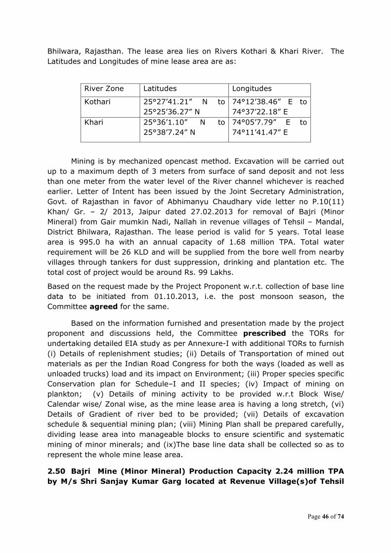
Page 46 of 74
Bhilwara, Rajasthan. The lease area lies on Rivers Kothari & Khari River. The Latitudes and Longitudes of mine lease area are as:
River Zone Latitudes Longitudes
Kothari 25°27’41.21” N to 25°25’36.27” N
74°12’38.46” E to 74°37’22.18” E
Khari 25°36’1.10” N to 25°38’7.24” N
74°05’7.79” E to 74°11’41.47” E
Mining is by mechanized opencast method. Excavation will be carried out up to a maximum depth of 3 meters from surface of sand deposit and not less than one meter from the water level of the River channel whichever is reached earlier. Letter of Intent has been issued by the Joint Secretary Administration, Govt. of Rajasthan in favor of Abhimanyu Chaudhary vide letter no P.10(11) Khan/ Gr. – 2/ 2013, Jaipur dated 27.02.2013 for removal of Bajri (Minor Mineral) from Gair mumkin Nadi, Nallah in revenue villages of Tehsil – Mandal, District Bhilwara, Rajasthan. The lease period is valid for 5 years. Total lease area is 995.0 ha with an annual capacity of 1.68 million TPA. Total water requirement will be 26 KLD and will be supplied from the bore well from nearby villages through tankers for dust suppression, drinking and plantation etc. The total cost of project would be around Rs. 99 Lakhs.
Based on the request made by the Project Proponent w.r.t. collection of base line data to be initiated from 01.10.2013, i.e. the post monsoon season, the Committee agreed for the same.
Based on the information furnished and presentation made by the project proponent and discussions held, the Committee prescribed the TORs for undertaking detailed EIA study as per Annexure-I with additional TORs to furnish (i) Details of replenishment studies; (ii) Details of Transportation of mined out materials as per the Indian Road Congress for both the ways (loaded as well as unloaded trucks) load and its impact on Environment; (iii) Proper species specific Conservation plan for Schedule–I and II species; (iv) Impact of mining on plankton; (v) Details of mining activity to be provided w.r.t Block Wise/ Calendar wise/ Zonal wise, as the mine lease area is having a long stretch, (vi) Details of Gradient of river bed to be provided; (vii) Details of excavation schedule & sequential mining plan; (viii) Mining Plan shall be prepared carefully, dividing lease area into manageable blocks to ensure scientific and systematic mining of minor minerals; and (ix)The base line data shall be collected so as to represent the whole mine lease area.
2.50 Bajri Mine (Minor Mineral) Production Capacity 2.24 million TPA
by M/s Shri Sanjay Kumar Garg located at Revenue Village(s)of Tehsil

Page 47 of 74
Bhilwara, District Bhilwara, Rajasthan (1947.12ha) (Consultant: Enkay
Enviro Services Pvt. Ltd., Jaipur)-TORs
The proposal of M/s Sanjay Kumar Garg is for River Sand Mining (Banas and Khari River) with Production Capacity 2.24 millionTPA of Sand in 1947.12 ha. The mine lease area is located near villages- Dhulkheda, Jeepiya, Bhadalikheda,Arajiya,Jodhras,Palari, Govindpura, Malan, Bhilwara, Sanganer, Kunwara, Suvana, Agarpura, Ghumras, Pondras, Chanpri, Duriya, Jawasiya, Sayla, Bhainsakundal, Bardod, Kanyakhedi, Biliyan kala, Swaroopganj, Guwaradi, Kalyanpura, Patliyas, Mangrop, Fagano ka kheda, Khairabad, Siyar, Darri, Mandapiya, Danta Jati, Kachauliya, Kumhariya, Pipli, Kalundiya, Maheshpura, Hasiyas, Dhogras, Akola., Tehsil &Distt.-Bhilwara, Rajasthan. The Latitudes and Longitudes of mine lease area are as follows:
River (Zone) Latitudes Longitudes Banas (I) 25°12’6.98” N to
25°15’45.11” N 74°29’47.83” E to 74°47’27.15” E
Kothari (II) 25°24’5.52” N to 25°20’47.33” N
74°34’36.54” E to 74°46’49.40” E
Mining is by mechanized opencast method. Excavation will be carried out up to a maximum depth of 3 meters from surface of sand deposit and not less than one meter from the water level of the River channel whichever is reached earlier. Letter of Intent has been issued by Joint Secretary Administration, Govt. of Rajasthan in favor of Sanjay Kumar Garg vide letter no P.10 (12) Khan/ Gr. – 2/ 2013, Jaipur dated 5th March 2013 for removal of Bajri (Minor Mineral) from Gair mumkin Nadi, Nallah and Khasara areas (excluding prohibited areas) in revenue villages of Tehsil and District - Bhilwara, Rajasthan. The lease period is valid for 5 years. Total lease area is 1947.12 ha with an annual capacity of 2.24 million TPA. Total water requirement will be 26 KLD and will be supplied from the bore well from nearby villages through tankers for dust suppression, drinking and plantation etc. The total cost of project would be around Rs. 16.91 Crores.
Based on the request made by the Project Proponent w.r.t. collection of base line data to be initiated from 01.10.2013, i.e. the post monsoon season, the Committee agreed for the same.
Based on the information furnished and presentation made by the project proponent and discussions held, the Committee prescribed the TORs for undertaking detailed EIA study as per Annexure-I with additional TORs to furnish (i) Details of replenishment studies; (ii) Details of Transportation of mined out materials as per the Indian Road Congress for both the ways (loaded as well as unloaded trucks) load and its impact on Environment; (iii) Proper species specific Conservation plan for Schedule–I and II species; (iv) Impact of mining on plankton; (v) Details of mining activity to be provided w.r.t Block Wise/
Page 48 of 74
Calendar wise/ Zonal wise, as the mine lease area is having a long stretch, (vi) Details of Gradient of river bed to be provided; (vii) Details of excavation schedule & sequential mining plan; (viii) Mining Plan shall be prepared carefully, dividing lease area into manageable blocks to ensure scientific and systematic mining of minor minerals; and (ix)The base line data shall be collected so as to represent the whole mine lease area.
2.51 Bajri Mine (Minor Mineral) Production Capacity 1.12 million TPAby
M/s Abhishek Chaudhary located at Revenue Village(s)of Tehsil Raipur,
District Bhilwara, Rajasthan (836.13ha) (Consultant: Enkay Enviro
Services Pvt. Ltd., Jaipur)-TORs
The proposal of Abhishek Chaudhary is for River Sand Mining (Kothari and Banas River) with Production Capacity 1.12 MMTA of Sand in 836.13 ha. The mine lease area is located near villages Mandi, Jhalamali, Chhatol, Ladki, Bhatewar, Thoriyakheda (Bheenta), Kalalkhedi, Borana, Dhulkheda (Bagoliya), Suras, Badi, Patiyon ka Kheda, Thala, Gadariyon ka Kheda, Bagoliya, Peethalpura, Nathariyas, Panotiya, Aspur, Fatehpura (Nahri), Nahri, Jogras, Dulhepura (Nahri), Shivnathpura, Tolas, Rewara, Boriyapura, Lakhaholi., Tehsil-Raipur, District-Bhilwara, Rajasthan. The lease area lies on River Kothari and Banas. The Latitudes and Longitudes of mine lease area are 25°23’32.61” N to 25°20’41.03” N and 74°01’7.64” E to 74°18’52.35” E respectively. Mining is by mechanized opencast method. Excavation will be carried out up to a maximum depth of 3 meters from surface of sand deposit and not less than one meter from the water level of the River channel whichever is reached earlier. Letter of Intent has been issued by the Joint Secretary Administration, Govt. of Rajasthan to Abhishek Chaudhary vide letter no P.10(8) Khan/ Gr. – 2/ 2013, Jaipur dated 27.02.2013 for Removal of Bajri (Minor Mineral) from Gair mumkin Nadi, Nallah(as per khasra) in revenue villages of Tehsil – Raipur, District - Bhilwara, Rajasthan. The lease period is valid for 5 years. Total lease area is 836.13 ha with an annual capacity of 1.12 million TPA.Total water requirement will be 21 KLD and will be supplied from the bore well from nearby villages through tankers for dust suppression, drinking and plantation etc. The total cost of project would be around Rs. 30.0 Lakhs. Based on the request made by the Project Proponent w.r.t. collection of base line data to be initiated from 01.10.2013, i.e. the post monsoon season, the Committee agreed for the same. Based on the information furnished and presentation made by the project proponent and discussions held, the Committee prescribed the TORs for undertaking detailed EIA study as per Annexure-I with additional TORs to furnish (i) Details of replenishment studies; (ii) Details of Transportation of mined out materials as per the Indian Road Congress for both the ways (loaded as well as

Page 49 of 74
unloaded trucks) load and its impact on Environment; (iii) Proper species specific Conservation plan for Schedule–I and II species; (iv) Impact of mining on plankton; (v) Details of mining activity to be provided w.r.t Block Wise/ Calendar wise/ Zonal wise, as the mine lease area is having a long stretch, (vi) Details of Gradient of river bed to be provided; (vii) Details of excavation schedule & sequential mining plan; (viii) Mining Plan shall be prepared carefully, dividing lease area into manageable blocks to ensure scientific and systematic mining of minor minerals; and (ix)The base line data shall be collected so as to represent the whole mine lease area. 2.52 Bajri Mine (Minor Mineral) Production Capacity 1.12 million TPAby M/s Mr. Mangal Singh Solanki located at Revenue village(s)of Tehsil
Chauth Ka Barwara, District Sawai Madhopur, Rajasthan (278.67ha)
(Consultant: Enkay Enviro Services Pvt. Ltd., Jaipur)-TORs
The proposal of M/s Mangal Singh Solanki is for River Sand Mining (Banas River) with Production Capacity 1.12 million TPA of Sand in 278.67 ha. The mine lease area is located near villages- Raipur, Solpur, Isarda, Sarsop, Devli, Samundrapura, Dhauli, Didaich, Banderia, Baghina, Jhonpara, Aincher, Abhaipura, Torda and Trilokpura., Tehsil-Chauth Ka Barwara, District- Sawai Madhopur, Rajasthan. The lease area lies on River Banas. The Latitudes and Longitudes of mine lease area are 26°08’11.75” N to 26°11’15.6” N and 76°05’33.78” E to 76°16’18.8” E respectively. Mining is by mechanized opencast method. Excavation will be carried out up to a maximum depth of 3 meters from surface of sand deposit and not less than one meter from the water level of the River channel whichever is reached earlier. Letter of Intent has been issued by the Superintending Mining Engineer (HQ), Directorate of Mines and Geology, Govt. of Rajasthan, Khanij Bhawan, Udaipur to. Mangal Singh Solanki vide letter no Dir. / P2 (A6) Tonk/ BAJRI/ 2012/ 191 dated 11.01.2013 for removal of Bajri (Minor Mineral) from Gair Mumkin Nadi, Nallah and Khasara areas (excluding prohibited areas) in revenue villages of Tehsil – Chauth Ka Barwara, District - Sawai Madhopur, Rajasthan. The lease period is valid for 5 years. Total lease area is 278.67 ha with an annual capacity of 1.12 million TPA.Total water requirement will be 6.2 KLD and will be supplied from the bore well from nearby villages through tankers for dust suppression, drinking and plantation etc. The total cost of project would be around Rs 5.53 Crores.
Based on the request made by the Project Proponent w.r.t. collection of base line data to be initiated from 01.10.2013, i.e. the post monsoon season, the Committee agreed for the same.
Based on the information furnished and presentation made by the project proponent and discussions held, the Committee prescribed the TORs for
Page 50 of 74
undertaking detailed EIA study as per Annexure-I with additional TORs to furnish (i) Details of replenishment studies; (ii) Details of Transportation of mined out materials as per the Indian Road Congress for both the ways (loaded as well as unloaded trucks) load and its impact on Environment; (iii) Proper species specific Conservation plan for Schedule–I and II species; (iv) Impact of mining on plankton; (v) Details of mining activity to be provided w.r.t Block Wise/ Calendar wise/ Zonal wise, as the mine lease area is having a long stretch, (vi) Details of Gradient of river bed to be provided; (vii) Details of excavation schedule & sequential mining plan; (viii) Mining Plan shall be prepared carefully, dividing lease area into manageable blocks to ensure scientific and systematic mining of minor minerals; and (ix)The base line data shall be collected so as to represent the whole mine lease area.
2.53 EC for mining of sand , Stone and bajri of M/s Goyal Crushing Co.
Village Manpur Devra, Tehsil – Paonta Sahib, Distt. Sirmour, H.P. (10.53
ha) (Consultant: Shivalik Solid Waste Management Ltd.)-Environmental
Clearance.
The proposal is river bed sand, stone and bajri mining with proposed
production of 1,00,000 TPA by M/s Goyal Crushing Company at Khasra No. 638/613/590/188/1, Village Mohkampur Nawada, Tehsil – Paonta Sahib, Distt. Sirmour, H.P. The Latitude and Longitude of the proposed site is 30o28’44.8” N to 30o28’30” N and 77o41’12.9”E to 77o41’12”E.
The proposal was considered by the expert Appraisal Committee in its meeting held during 23-25th March, 2011 to determine the terms of reference for undertaking detailed EIA study. The TOR was issued by MOEF vide letter No. J-11015/18/2011-IA.II (M) dated 28th April 2011 for mining of mineral Sand, Stone and Bajri. The proponent submitted its application to MoEF (along with minutes of Public consultation) for seeking environmental clearance after conducting Public Hearing.
The mining lease area is 10.53 ha which a riverbed. The mining plan is approved by Geology wing of Industry department, Himachal Pradesh. The mining plan is approved by State Geologist vide letter No Udyog-Bhu (Khani-4) Laghu-518/09-5307 dated 10.9.2013.
The mining method shall be manual using hand tools for collection of sand
stone and bajari from the river bed. 7500 metric ton of silt and clay will be produced per year which will be used for back filling the pits. There is no intersection of ground water as mining would be carried out for one meter depth only. It was reported by the PP that there is no protected area viz wild life Sanctuaries/ Tiger Reserve/ National Park/ Schedule I species etc. within 10km of the mine.
Page 51 of 74
Baseline studies were carried out during pre monsoon/ summer season 2011. All the parameters of water and air quality were reported to be within permissible limits. The public hearing for the project was conducted at village Nawada Tehsil Paonta Sahib on 17-05-2012. The Public Hearing was chaired by ADC (District Sirmaour). The issues during the public hearing were also considered and discussed during the meeting, which inter-alia, included that mining activities are carried out as per stipulate guidelines, sprinkling of water etc. as per villager’s requirements, it is informed by the Project proponent that they would take care of local employment, invest funds for social development in the area etc. These have been incorporated in the Project plan and budgetary provisions.
The cost of Environmental protection measures is Rs 4.95 lakhs. Project Proponent has made provision of free building material for school, religious building etc in consultation with Village Panchayat under CSR. It is reported by Project Proponent that there is no court case / litigation against the project and no violation. Based on the presentation made and discussion held, the Committee decided to defer the proposal to be brought back to the Committee after the following information is submitted: (i) Revised EIA/EMP report along with questionnaire shall be submitted, and (ii) details of replenishment study shall be submitted. 2.54 Metabodeli Iron Ore mining Project with production capacity of
0.20 MTPA of M/s Jayswal Neco Industries Ltd located at Pakhanjur,
district Kanker, Chattisgarh (50.00ha). (Consultant: Srushti Sewa Geo
Solutions (P) Ltd.)-EC reconsideration.
The Proposal was deferred on the request of the Project Proponent.
2.55 Collection of sand stone and bajri mining lease of M/s Devraj Stone Crusher, located at village Newada, Tehsil Paonta Sahib, District
Sirmour, Himachal Pradesh (9.668 ha) – (Shivalik Solid Waste
Management Ltd.) –EC reconsideration.
The proposal is for production of 77,500 TPA of sand, stone and bajri put
together from the bed of river Giri. The mine lease area is 9.668 ha. No forestland is involved. It has been considered as Category ‘A’ because of inter-state boundary with Uttarakhand at a distance of 5 km. Mining will be manual without any drilling and blasting. The Mine lease is located between Longitude 77°41’ 06” - 77°41’ 15.8” and Latitude 30°28’56.1” – 30°28’ 59.4”.
The proposal was earlier considered in EAC meeting held during January
16-18, 2013. Committee sought following additional information:
Page 52 of 74
1. Project Proponent should collect the fresh data during up-coming summer season March-May and resubmit.
2. Data should be for Proponent’s own mine lease area. 3. Primary survey of flora and fauna should be carried out and report
submitted.
On submission of information on above mention points, proposal was considered in the present meeting. The project proponent submitted the fresh data from March-May 2013, and the Committee noted that the cardinal environment parameters were within the prescribed limits. The report on the primary flora and fauna indicated that no schedule-I species are reported in the study area. Based on the information submitted, presentation made by the proponent and discussions held, the Committee recommended the proposal for environmental clearance.
2.56 Amilia Limestone Mine for enhancement of production capacity
from 01. Million TPA to 1.25 million TPA of Limestone (ROM) by M/s KJS
Cement Ltd., located at Village Amilia, Tehsil Maihar, District Satna,
Madhya Pradesh (217.512ha) (Consultant: Bhagavathi Ana Labs Ltd.,
Hyderabad)-Reconsideration of EC.
The proposal is for enhancement of production of limestone from 0.1 million TPA to 1.25 million TPA for captive use in their cement plan by M/s KJS Cement Ltd., located at Beldara, Girgita, Amilia Khurd, Lakhwar, Katia, Tighra & Maihar Villages, Maihar Tehsil, Satna District, Madhya Pradesh. The Latitudes and Longitudes of the site are 24°14’42.1” N to 24°15’47.5” N and 80°48’19.2” N to 80°49’14.7” E.
The proposal was considered by the Expert Appraisal Committee in its meeting held during 28-30th June, 2010 to determine the Terms of Reference (TOR) for undertaking detailed EIA study. The TORs were issued by MoEF vide letter no. J-11015/175/2010-IA.II(M) dated 30th July, 2010. The proponent submitted its application to the Ministry for seeking environmental clearance after conducting public hearing. The project was considered in the EAC held during December 19 -21, 2012 wherein the Committee deferred the proposal and sought additional information/ clarifications with regard to R&R details and Ecological status of Tamas River. The project proponent submitted the clarifications to MoEF vide letter dated 07.06.2013.
The Amilia Limestone mine is situated at Amilia Village in Maihar Tehsil of Satna District in Madhya Pradesh State. Amilia Limestone mine lease was initially granted to M/s Diwan Lime Co. Pvt. Ltd in the year 1971 by Government of Madhya Pradesh, covering an area of 217.512 ha for 20 years period w.e.f. 01.10.1971 to 30.09.1991. The area was worked as quarry lease before 1971. Thereafter the mining lease was renewed for 10 years i.e. fom 01.10.1991 to 30.09.2001. Further the mine lease has been renewed for 20 years i.e. for the

Page 53 of 74
period up to 2021. Meanwhile the name of the company changed from Diwan Lime Co. (Pvt) Ltd to KJS cements Pvt. Ltd. on 15.11.2007. The supplementary agreement to this effect was executed on 13.09.2009. The constitution of the company was again changed from Private Limited to Limited. The mining plan for renewal was approved. The scheme of mining is approved by Indian Bureau of Mines vide letter No. 314(3)/2012-MCCM (CZ)/S-25/248 Nagpur Dated: - 17/12/2012 for the production of 1.25 million TPA Limestone.
The Proposal is for enhancement of production of limestone to 1.25 million TPA for captive use in their cement plant. The mine is reported to be closed presently. No forestland is involved. Mine working will be opencast mechanised involved drilling and blasting. Life of mine is 32 years. Ultimate working depth will be 32 m from general surface level (320 m ASML). Mine working will intersect groundwater table. Tamas River passes through the mine lease. Part of the lease area is Government land and partly agricultural land. The major portion of the study area has been covered by agricultural land (386.38 ha). Other land uses include plantations (0.44 ha), vegetation (7.86 ha), settlements (18.20 ha), water body (11.73 ha) and other areas for dumps and colony.
Baseline data was collected during post-monsoon season in 2010. The baseline AAQ during the study period was below the prescribed National Ambient Air Quality standards. The M.P.P.C.B had conducted Public Hearing on 18.04.2011. Public hearing was conducted and issues raised by public were addressed by the project proponent with commitment for implementation. The Committee observed that even though there are 133 families with 684 people are within the premises of mine lease area, there is no mention of this issue in EMP report. Even though the Tamas River is flowing through mine lease area, no detailed studies had been carried out for possible pollution impacts.
Based on the presentation made, information furnished and discussions held in the EAC meeting held December 19-21, 2012, the Committee sought additional information on following and decided that the Proposal may be brought back before the Committee for its further consideration after receipt of requisite information:
(i) R&R details for land oustees with compensation details should be provided.
(ii) Detailed ecological studies on Tamas River should be provided.
The Proponent had submitted the information and accordingly, the proposal is considered in the meeting. Based on the presentation made, information furnished and discussions held in the EAC meeting, the Committee was of the view that the details submitted by the PP are not satisfactory. Also, information on number of schools and their distance from the MLA, Community Facility to be provided by the PP, no. of Temples in the vicinity and efforts to be

Page 54 of 74
initiated for tribals etc. was found deficient. The Committee sought additional information on following:
(i) R&R details for land oustees with compensation details; details w.r.t. number of schools and their distance from the MLA, Community Facility to be provided by the PP, number of Temples and other social amenities in the vicinity;
(ii) Detailed ecological studies on Tamas River should be conducted and report on impacts and their mitigation provided.
(iii) Details of water management plan as the mining activity is intersecting the ground water table; and
(iv) Details of time bound action plan for tribal population.
The Committee decided to defer the proposal to be brought back to the Committee after the aforesaid information is submitted.
2.57 Mangrol Tilakhera Limestone Mine for enhancement of production from 0.6 million TPA to 1.6 million TPA of limestone (ROM) by M/s JK
Cement Works, located at Mangrol, Tehsil Nimbahera, District
Chittorgarh, Rajasthan (299.20ha) (Consultant: Enkay Enviro Services
Pvt. Ltd. Jaipur)-Reconsideration of EC.
The proposal of M/s JK Cement Works is for enhancement of production from 0.6 million TPA to 1.6 million TPA of limestone (ROM) in 299.20 ha. The mine lease area is located near villages-Mangrol-Tilakhera, Tehsil-Nimbahera, District-Chittorgarh, Rajasthan. The Latitudes and Longitudes of mine lease area are 24°41’33.0“N to 24°42’44.4”N and 74°40’59.5”E to 74°41’48.3” E respectively.
The proposal was considered by the Expert Appraisal Committee in its meeting held during 28th – 30th November, 2011 to determine the Terms of Reference (TOR) for undertaking detailed EIA study. The TORs were issued by MoEF vide letter no. J-11015/25/2011-IA.II (M) dated 28th December 2011. The proponent submitted its EIA/EMP report to the Ministry for seeking environmental clearance after conducting public hearing. Accordingly, the proposal was considered in the 6th Meeting of the Reconstituted Expert Committee (Mining) held during April 16-18, 2013 wherein the Committee deferred the proposal and sought additional information. Mining is by mechanized opencast method. The mine lease area is 299.20 ha, out of which 120.50 ha is Govt. waste land, 34.00 ha grazing land and 144.70 ha Agriculture land. No forestland is involved. Water table will not be intersected as the ultimate pit limit (395 MSL) is almost 36m below the general ground level (431 MSL), while the water level is 60m below the general ground level. The Mining Plan was approved by Controller of Mines, Indian Bureau of Mines vide letter no. 682 (23) (500)/ 94-MCCM-(N) UDP dated 31.07.1995. Scheme of Mining was approved vide letter no. 682 (23)MS-531/ 09 MCCM(N)
Page 55 of 74
Udai dt. 04.08.2010. Modified Scheme of Mining with PMCP has been approved vide letter no. 682 (23) MS-589/ 2010 dated 25.07.2011. Life of mine is 15 years. Water requirement for the project is 50 kld.
The mine has been granted Environmental Clearance vide letter no. J-11015/82/2004-IA. II dated 30th May 2005 from MoEF for expansion of the capacity from 0.36 million TPA to 0.6 million TPA. This is captive mining for the linked cement plant which has waste heat recovery boiler and captive power plant adjacent to the mine. The proponent stated that separate environmental clearance is being obtained for different industrial activities.
There is no National Parks, Wildlife Sanctuaries, Biosphere Reserves and Tiger/Elephant Reserves within 10 km radius of the mining lease boundary. One Schedule I species namely Pavo cristatus was reported. Accordingly, a Conservation plan for schedule-I species has been prepared. The Committee discussed the conservation plan. The baseline data was generated for the period during December 2011 to February 2012. All the parameters for water and air quality were seen to be within permissible limits.
The Public hearing was held on 20.12.2012 under the chairmanship of Shri Jagvir Singh, Chief Executive Officer. The representative of Regional Office from the Rajasthan State Pollution Control Board was present. The proponent informed that the Chairman of the public hearing is of level of ADM as per EIA Notification, 2006. The issues raised during public hearing were also considered and discussed during the meeting, which inter-alia, included the problems related to blasting, efforts done by the company on grazing land, flora and fauna, employment to local persons etc. These have been incorporated in the project plan with budgetary provisions and time bound action plan. The total cost of the project is Rs. 2.5 Crores. The PP has earmarked Rs. 6.97 Lakhs towards Environmental Protection Measures and Rs. 16.3 Lakhs per annum towards recurring expenses. PP reported that there is no court case/litigation pending against the project.
The Committee in its meeting held during April 16-18, 2013 had deferred the proposal and sought the following additional information/clarifications:
(i) The different lease areas are mentioned in earlier EC and present TORs. As prior environmental clearance for 0.6 million TPA was granted in May, 2005 for 299.20ha, however, the TORs for enhancement was prescribed for 293.2ha.
(ii) The Reason why the PP has not requested for the amendment of
mine lease area in the prescribed TOR.
Page 56 of 74
(iii) Action plan on the issues raised in the Compliance report of Regional Office of MoEF.
(iv) Action plan with budgetary provisions to be provided for issues
raised in the Public Hearing. The PP vide letter dated 12.06.2013 had submitted the above mentioned information to the Ministry. The Committee deliberated the above mentioned issues viz. lease area, action plan on the issues raised in the Compliance report of Regional Office of MoEF and Action plan with budgetary provisions for issues raised in the Public Hearing.
Based on the information submitted, discussion held, the Committee recommended the proposal for environmental clearance for the enhancement of Limestone Production Capacity from 0.6 million TPA to 1.6 million TPA (ROM).
2.58 Bambora Red Ochre Mines of M/s Suresh Prakash Sarda located at
Village- Bambora, Chhoti Sadri, District- Pratap Garh, Rajasthan (47.425
ha) (Consultant: M/S Team Institute of Science & Technology Pvt. Ltd.)-
Reconsideration of EC
The proposal is for renewal of mine lease which fell due in 2006 and enhancement of production of red ochre from 99,000 TPA to 1,39,613 TPA by M/s Suresh Prakash Sarda. The mine is located at Bambora, Chhoti Sadri, District- Pratap Garh, Rajasthan. The Latitudes and Longitudes of the site are 24°24’27” N to 24°25’33” N and 74°44’25” N to 74°45’09” E.
The proposal was considered by the Expert Appraisal Committee in its meeting held during 20-22, February, 2008 to determine the Terms of Reference (TOR) for undertaking detailed EIA study. The TORs were issued by MoEF vide letter no. J-11015/777/2007-IA.II(M) dated 4th April, 2008. The proponent submitted its application to the Ministry for seeking environmental clearance after conducting public hearing. The project was considered in the EAC meeting held during November 28-30, 2011 wherein the proponent made a presentation on the same.
The proposal was for renewal of mine lease which fell due in 2006 and enhancement of production of red ochre from 99,000 TPA to 1,39,613 TPA. The mine lease was transferred in the name of the present lessee in 1995. It is a violation case as the production from the mine was enhanced after 1994 without obtaining requisite prior environment clearance. The mine is reported to be closed since May, 2004. The mine lease area is 47.424 ha. It has been considered as category ‘A’ because of its location within 10 km of the interstate boundary. No forestland is involved however; 5.681 ha of grazing land is involved in the mine lease. Mine working will be opencast. The ultimate working depth will be up to 3 m bgl. The water table is reported to be at 14 m bgl. The mine working will not intersect the ground water table. Backfilling is proposed.

Page 57 of 74
The baseline AAQ data showed the levels to be within permissible limits. It was stated that 7.71 ha of mined out area will be used for water harvesting. It was categorically stated that the area does not fall under Aravalli. A letter from the Assistant Mining Engineer dated 13.10.2010 has been submitted in this regard. It has also been stated that no national park/sanctuary/wildlife corridor falls within 10 km of the mine lease. TOR for this project were prescribed on 04.04.2008. Public hearing has been held on 20.06.2011. The issues raised during public hearing were also considered and discussed during the meeting. It was reported that there is no court case pending against the project.
Based on the presentation made and discussions held in the aforesaid Meeting of November, 2011, the Committee had sought information on the following:-
(i) A certificate from the Competent Authority in the State Government permitting the use of grazing land involved in the project for mining.
(ii) The biological study of the study area should be undertaken and details furnished.
(iii) A certificate from the Competent Authority confirming that no forestland is involved in the project and that no national park/sanctuary is within 10 km of the mine lease.
(iv) Action plan to address the issues raised during public hearing should be provided.
(v) The letter regarding the mine lease not falling in Aravalli should be obtained afresh from the Competent Authority clearly mentioning the coordinates of the lease area.
The Committee had decided that the proponent will submit the response/information on the above-mentioned points and thereafter the proposal will be considered by the EAC during.
Based on the aforesaid additional information/clarifications submitted by the proponent, the proposal was considered again in EAC meeting held during April 16-18, 2012. The Committee took note of the order dated 13.12.2011 from the Govt. of Rajasthan, wherein it was stated that the mine leases in respect of applications submitted prior to 25.4.2011 in which grazing land is involved in part or in full, LOI / leases will be granted only after approval of the Department of Revenue. The proponent is yet to submit the same. It was also noted that the mine lease area does not involve any forestland and that Sita Mata National Park is about 20 km from the mine lease. A letter confirming that the mine lease area does not fall in Aravali as submitted by the proponent was not specific and did not mention anything about the applicability of the order of the Hon’ble Supreme Court on the subject as was asked for.
Page 58 of 74
Based on the presentation made and discussions held in that meeting of April 2012, the Committee again sought information on the following and deferred the proposal and to be brought back before the Committee for its further consideration after the requisite information submitted.
(i) NOC from the Competent Authority in the State Govt. for use of grazing land for mining in the mine lease area may be furnished.
(ii) A confirmation may be adduced, duly authenticated by the competent authority in the State Government to the effect whether the project falls in Aravalli and whether it is covered by the order of the Hon’ble Supreme Court dated 8.4.2005 in the contempt petition (c) 412/2004 in writ petition 202 of 1995 in the matter of Godavarman vs Union of India.
(iii) Time bound action plan along with financial outlay to address the issues raised during public hearing should be given.
The PP had submitted the above mentioned information and accordingly the proposal is considered in the present Meeting. The Committee deliberated the issues w.r.t. to NOC for use of grazing land, confirmation letter from the State Government to the effect that the project does not fall in Aravalli and Time bound action plan along with financial outlay to address the issues raised during public hearing. The Committee noted that PP has provided the details w.r.t. Time bound action plan on the issues raised during Public Hearing, confirmation letter from the State Government to the effect that the project does not fall in Aravalli The Committee after deliberation recommended the proposal with additional specific
condition that mining activity shall not commence until NOC from the State Govt. for use of grazing land for mining in the mine lease area is obtained.
2.59 Proposed lime stone mine (602 ha) production capacity (2.6 MPTA) of M/s Lafarge India Pvt. Ltd. located at near village Sita Ram Ji Ka
Khera, Tehsil Nimbahera, District Chittorgarh, Rajasthan (Consultants: J M Environment Pvt. Ltd., Gurgaon)-Re-consideration of Environmental
Clearance.
The proposal is for opening a new Limestone Mine (602 Ha) with proposed production capacity of 2.6 MTPA located near village Sita Ram Ji Ka Khera, Tehsil- Nimbahera, District- Chittorgarh Rajasthan. The proposal was considered by the EAC in its meeting held during 25th-27th July, 2012 to determine the Terms of Reference (TOR) for undertaking detailed EIA study. The TORs were issued by MoEF vide letter no. J-11015/268/2012-IA.II (M) dated 11th October, 2012. On submission of EIA/EMP report the proposal was placed in EAC meeting held during June 26-28th 2013. Based on the discussion held, Committee sought following information (i) the mine working may intersect ground water table at later stages of mine life. The Committee was of the view that in such a case, Hydrogeology study needs to be conducted through a reputed institution. (ii) considering the scheduled-I sp. found in the study area, a conservation plan shall be submitted. The conservation plan should have the following components: species specific conservation action, budgetary provisions,
Page 59 of 74
implementing agencies and monitoring mechanism. (iii) Three villages/human settlements are located within the mine lease area. The committee desired to know regarding the measures being proposed for protection of these villages. To this the PP informed that they proposed to develop a green belt. The Committee was of the view that just green belt development will not be sufficient and additional dust, sound and vibration mitigation barricading measure(s) should be explored and provided for. The Green belt within the Lease area to shield the villages should consist of Stratified layers of trees of local species and of appropriate heights to serve the intended objective of protecting the adjacent villages/human settlements. The proposal was considered in the present meeting on the submission of information and request of project proponent. The project proponent informed that:
I. In first five years, no ground water intersection will take place. Mine working may intersect ground water table at later stages of mine life. Detailed Hydro-geological Study has been carried out for the project in this regard Necessary Permission from respective authority will be obtained by LIPL for the same as and when required.
II. The conservation plan was submitted by the project proponent and was discussed by the committee.
III. The pp submitted the proposal for stratified layer system of plantation which included specific herbs shrubs and trees to be planted in various rows which would effectively mitigate the additional dust, sound and vibration.
The Committee was of the view that no ground water intersection will take
place for first five years of mine working. However, the proposal should be placed before the committee as and when ground water intersection is proposed. As per the reports and information furnished, clarifications given and discussion held, the Committee recommended the proposal for grant of environmental clearance with specific condition that:
The proposal shall be placed before the committee as and when ground water intersection is proposed for mining.
2.60 Thakurani Iron Ore Mine Block B of M/s Sarda Mines Pvt. Ltd.,
Village Soyabali, Balita & Thakurani RF, District Keonjhar, Odisha
(947.04ha) (Min Mec Consultancy Pvt. Ltd.)-Reconsideration
Environmental Clearance.
Thakurani Iron Ore Mine Block B of M/s Sarda Mines Pvt. Ltd is located
at village Soyabali, Balita & Thakurani RF, District Keonjhar, Odisha. The site is bounded by Latitude 22˚ 04‟ N to 22˚ 07‟ N and Longitude 85˚ 25‟ E to 85˚ 28‟ E, within the survey of India Topo sheet No. 73F/8. The prior Environmental Clearance was issued by MoEF vide letter no. J-11015/1176/2007-IA.II(M) dated 29th October, 2008. The proposal is for extending the validity of the Environmental Clearance.
Page 60 of 74
The proposal was earlier considered in EAC meeting held during May 15-
17, 2013. The committee was of the view that an updated compliance report shall be submitted from Regional Office of MoEF with details on the following:
i. The monitoring data to indicate quantitative and statistical details.
Monitoring data should be collected by NABL/MoEF accredited laboratory.
ii. Status of Environmental cell in case constituted. iii. Status of Slope stabilization.
On submission of information on above mention points, proposal was
considered in the present meeting. PP submitted the updated compliance report from Regional Office of MoEF the report contained the monitoring data with quantitative and statistical details. It was informed by PP that an Environmental cell has been constituted. For slope stability the boulder wall is made atleast 5-6 mt away from the toe of dump with proper weeping holes and garland drain. Based on the information submitted, presentation made by the proponent and discussions held, the Committee recommended the proposal for environmental clearance.
2.61 Jereldaburu Iron Ore Mine of M/s Jindal Steel & Power Ltd.,
located at Village District West Singhbhum, Jharkhand. (537 ha) (Consultant: Bhagavathi Ana Labs Ltd., Hyderabad)-Reconsideration of
EC
The proposal is for opening of a new mine for production of 6.0 million TPA of iron ore by M/s Jindal Steel & Power Ltd. The mine lease area is located in village Jereldaburu, Taluka Gua in West Singbhum district of Jharkhand State. The Latitudes and Longitudes of the mine lease area are 22°15'00” N & 22°17'00” N and 85°22'42” E & 85°24’21” E respectively and fall under Survey of India, Toposheet No. 73 F/7. The proposal was considered by the Expert Appraisal Committee in its meeting held during 21-23 May, 2008 to determine the Terms of Reference (TOR) for undertaking detailed EIA study. The TORs were issued by MoEF vide letter no. J-11015/1208/2007- IA II (M) dated 25th June, 2008.The proponent submitted the EIA/EMP report to the Ministry for seeking environmental clearance after conducting public hearing.The proposal for EC was earlier placed in the EAC meetings held during March 18-20, 2009, July 16-17, 2009 & August 2009 wherein the Committee sought the information/clarifications. The baseline data was generated for the period during pre-monsoon season i.e. March 2008 to May 2008. All the parameters for water and air quality were within permissible limits. The Committee noted that the base line

Page 61 of 74
monitoring data were prior to the issuance of TORs. PP informed the Committee that they had requested to use the base line data during the presentation in the EAC meeting held during May 21-23, 2008 to determine the TORs, however it was not reflected in the Minutes of the meeting. The Committee deliberated the issues and were of the opinion that as the base line data was in accordance with the prescribed TORs and the basic parameters are well within the permissible limits as prescribed by the CPCB, the base line data could be accepted. The mine lease area is 537 ha, which is a forestland. The mine is located in Singhbhum Elephant Reserve. No beneficiation plant is proposed as part of this project, however, dry crushing and screening is proposed. The TORs for this project were prescribed on 25.06.2008. The public hearing for this project was held on 03.11.2008. The mine working will be opencast mechanized involving drilling and blasting. The ultimate working depth will be 420 m AMSL. The groundwater table is at 340 m AMSL. Mine working will not intersect groundwater table. Life of the mine is 20 years. The Iron Ore Block was allotted by the Ministry of Mines vide letter no 5/93/2007-M-IV dated 24-08-2007 and by the Director of Mines, Govt. of Jharkhand vide letter dated 6-09-2007. The Mining Plan has been approved by Indian Bureau of Mines, Nagpur on 12-08-2008 and same plan was revised on 13.07.2009. Water requirement is 1248 m3/day, which will be obtained from Karo river. It is estimated that 13.953 million m3 of waste will be generated during mine life, which will be backfilled. The mineral transportation is proposed by road during initial two years of mine working and thereafter it will be through pipe conveyor. It was also stated that high pressure canon will be deployed for control of pollution during blasting. The total cost of the project is Rs. 500 Crores. The PP has earmarked Rs. 26.34 crores towards Environmental Protection Measures as a capital cost and Rs. 5.61 crore per annum as a recurring expenses. PP informed that Rs. 5 Crore have been earmarked towards CSR activities as capital and Rs. 60 lakhs as recurring expenses.
Based on the presentation made and discussions in the EAC meeting held during March 18-20, 2009 wherein the Committee had sought the following information and decided that the proposal be brought back before the Committee for its further consideration after the requisite information as mentioned below has been received.
(i) Details of the pipe conveyor including its route, the details of land requirement (ROW) for laying the pipe conveyor, R&R involved therein, if any, nature of land etc. The status of land acquisition / ROW for the same should also be given. (ii) Details of high pressure canon system proposed to be deployed for control of pollution should be provided. Its effectiveness in control of
Page 62 of 74
pollution should also be given. It may also be indicated as to which of the mines are using this technology internationally. (iii) The data contained in the filled in Questionnaire should be reconciled and the corrected Questionnaire so filled should be furnished. (iv) Information regarding topography of the area should be given. It may be noted that the information given in different documents in this regard is at variance, which may be reconciled. (v) The details of first order streams emanating from the mine lease area and impact of the proposed project on the same and thereby on the hydrology of the area. (vi) Details and schedule of backfilling. (vii) Details of external OB dump, if any. (viii) The mine plan should be inconformity with the proposed scheme of waste management i.e. the backfilling schedule and external OB dump proposed in the project should be duly integrated and incorporated into the approved mining plan. Wherever necessary, the mine plan should be modified and got approved and submitted. (ix) Keeping in view the schedule of backfilling and external OB dump, the post mine land use should be modified accordingly and submitted. (x) Information on baseline AAQ data particularly the SPM, RSPM, NOx and the contribution of the proposed project should be given. (xi) Location of National Parks, Sanctuaries, Biosphere Reserves, Wildlife corridors, Tiger/Elephant reserves (existing as well as proposed), if any, within 10 km of the mine lease should be clearly indicated. A location map duly authenticated by Chief Wildlife Warden should be provided in this regard. Necessary clearance, if any, as may be applicable to such projects due to proximity of the ecologically sensitive areas as mentioned above should be obtained from the State Wildlife Department/ Chief Wildlife Warden under the Wildlife (Protection) Act, 1972 and copy furnished. It being a green field project to be located in the Singhbhum Elephant Reserve, NOC from Chief Wildlife Warden and the necessary mitigation measures required, if any, should be furnished. Status of forestry clearance should also be provided. (xii) Action plan to address the issues raised during public hearing along with financial allocation.

Page 63 of 74
(xiii) Wind rose and isopleths to be rechecked and reconfirmed. (xiv) A written commitment that no red water will be discharged into the river and the proposed safeguard measures for the same. (xv) A copy of the approved Wildlife Conservation Plan specific to the project should be submitted.
The Project Proponent had submitted the above mentioned
information/clarifications which were sought by the Committee and accordingly the proposal was again reconsidered in the EAC meeting held during July 16-17, 2009. Followings were the discussions:
It was stated that the mineral transportation will be carried out through closed pipe conveyor. The length of the pipe conveyor will be 5.447 km for which an area of 8.17 ha will be required. No displacement of population is involved due to the conveyor. During initial two years when the pipe conveyor will be under construction, mineral transportation will be by road. It was clarified that the site elevation varies between 340 m AMSL to 750 m AMSL. The mining operation will be carried out by slicing method and after mining the excavated profile will match with the existing profile of the land. The drainage and general hydrology will remain unaltered. It is estimated that an area of 36.15 ha will be required for OB dump. It was, however, observed that in the modified approved mine plan, it has been stated that backfilling shall be proposed in the 2nd scheme of mining for the next five years. It, therefore, lacked consistency and needs further clarifications. It was also pointed out that NOC from Chief Wildlife Warden for operating the mine within the core zone of Singhbhum Elephant Reserve, as sought earlier has not been furnished. It was categorically stated that no red water will flow out of the mine lease area. Silt check dams will be constructed. The issues raised during public hearing were also considered and discussed. The other issues raised by the Committee were also clarified. Based on the presentation made and discussions held, the Committee sought information on the following:-
(i) It may specifically be clarified whether the proposal involves any backfilling of the OB generated from the mine. Consistency of the information contained in the project documents and the presentation made should be shown.
(ii) NOC from Chief Wildlife Warden for working of the proposed mine within core zone of the Singhbhum Elephant Reserve should be furnished.
The proposal was reconsidered by the Expert Appraisal Committee during its meeting held on August 2009 wherein the Committee observed that the requisite NOC from the Chief Wildlife Warden for working of the proposed mine within core zone of the Singhbhum Elephant Reserve as sought earlier has not
Page 64 of 74
been furnished. The letter dated 06.08.2009 from the Chief Wildlife Warden, Jharkhand submitted by the project proponent cannot be taken as NOC from National Board of Wildlife. The Committee further noted that the application for diversion of forestland proposal is still under consideration at the regional level. Based on the discussions, the Committee deferred its decision on the project for want of requisite NOC from the Chief Wildlife Warden, it being a green field project to be located in the core zone of the Singhbhum Elephant Reserve and also recommended for closure of the project file till the requisite NOC is received.
The Proponent vide letter dated 27.05.2013 has submitted the followings clarification to the Ministry:
(i) For the issue of NOC under Wildlife Protection Act, 1972, M/s JSPL had applied to Department of Wildlife, Govt. of Jharkhand on 24-04-2012 in accordance with the guideline dated 15.03.2011. However, in accordance with recent circular by Wild Life Division of MoEF on “Guidance document for taking up non forestry activities in Wild Life habitats” dated 19th Dec 2012, Environment and Forest Department, Government of Jharkhand in its letter No 1356 dated 27-06-2013 and letter No 19/2012/1310, dated 19-03-2013 has clarified that obtaining NOC is not required from National Board of Wildlife for projects falling in Elephant Reserve. PP informed that the Government of Jharkhand had appointed an Expert Committee through notification dated 27/8/2011 for preparation of Integrated Wild Life Conservation Plan. The Committee has already submitted the Wildlife Management Plan for the area to the Dept of Forest, Govt. of Jharkhand. PP informed that JSPL has submitted an Undertaking to the State Forest Department for abiding by the guidelines of this Integrated Wild Life Conservation Plan and contribute proportionately in the preparation and implementation of the Plan. (ii) PP informed that the MoEF has granted Stage-I Forest Clearance for Diversion of 538.93 ha of forest land for the project (mine lease and conveyor route) vide its letter no. F.No. 8-60/2010-FC, dated 22-05-2013.
The Committee deliberated the submissions made by the PP and based on the information submitted, presentation made and discussion held, the Committee recommended the proposal for environmental clearance for the opening of a new mine for production of 6.0 million TPA of iron ore (ROM).
2.62 Limestone Mining capacity reduction from 0.477 million TPA to
0.305 million TPA and Setting up of Crushing Plant of Capacity 2.0
million TPA by M/s Madras Cement Ltd., located at Village Pandalgudi,
Velayuthapuram & Chettipatti, Taluk Aruppukottai, District Virudhnagar,
Page 65 of 74
Tamil Nadu. (189.45ha) (Consultant: Mineral Engineering Services)-
Amendment in EC
The Ministry of Environment & Forests has accorded the Environmental Clearance to M/s Madras Cements Ltd. for Limestone Mining capacity of 0.477 million TPA and Setting up of Crushing Plant of Capacity 2.0 million TPA vide J-11011/544/2007.IA. II (M), dated 26th March, 2009. The plant is located at Village(s) Pandalgudi, Velayuthapuram & Chettipatti, Taluk Aruppukottai, District Virudhnagar, Tamil Nadu.
The PP has requested to reduce the production capacity from 0.477 million TPA to 0.305 million TPA of Limestone (ROM) in the ML area of 189.45ha. PP informed that IBM has approved the scheme of mining for production of 0.305 million TPA vide letter no. TN/VRD/MS-567-SZ, dated 18.11.2011.
The Committee deliberated the submissions made by the PP and based on the information submitted, discussion held, the Committee recommended the amendments in EC for reduction of production capacity from 0.477 million TPA to 0.305 million TPA of Limestone (ROM) in the ML area of 189.45ha.
2.63 Zinc smelter (5,00,000 TPA), Lead smelter (1,25,000 TPA), Captive
Power Plant (255 MW) and Expansion of Rajpura Dariba Mine (6,31,000
to 9,00,000 TPA) along with Beneficiation Plant (9,00,000 to 12,00,000
TPA) by M/s Hindustan Zinc Ltd. located at Village Dariba, Tehsil
Relmarga, District Rajsamand, Rajasthan- Amendment in EC
The Ministry of Environment & Forests has accorded the Environmental Clearance to M/s Hindustan Zinc Ltd for integrated mining project of lead zinc ore mining for the capacity Zinc smelter (5,00,000 TPA), Lead smelter (1,25,000 TPA), Captive Power Plant (255 MW) and Expansion of Rajpura Dariba Mine (6,31,000 to 9,00,000 TPA) along with Beneficiation Plant (9,00,000 to 12,00,000 TPA) vide J-11011/380/2008.IA. II (I), dated 4th November, 2009. The plant is located at Village Dariba, Tehsil Relmarga, District Rajsamand, Rajasthan.
The Project Proponent mentioned that Rajpura Dariba mines was due for renewal on 30.05.2010 and the same was incorporated in all the documents submitted to the MoEF, however the same was not categorically mentioned in the Environmental Clearance issued by the MoEF (Industry Sector of IA Division). PP requested to amend the EC issued on 4.11.2009 with respect to the mine lease renewal matter as the amendment to the EIA notification, 2006 issued by MoEF vide dated 4th April, 2011 that EC was coterminous with renewal of mine lease. As in this case, the mine lease fell due on 30.05.2010 i.e. prior to the issue of above mentioned notification thus this provision was not applicable.

Page 66 of 74
The Committee was of the view that no fresh EC is required until the expansion of the production or change in scope/technology is proposed.
2.64 Captive Limestone Mining Project by M/s Ultra Tech Limited,
located at Distt. Neemuch, Madhya Pradesh. (Consultant: J.M. Enviro Net
Pvt. Ltd.)- Amendment in EC
The Ministry of Environment & Forests has accorded the Environmental Clearance to Vikram Cement Limited for limestone mining of 1.5 million TPA vide J-11011/38/2011.IA. II (M), dated 21st July, 2003. The plant is located at villages Suvakheda, Morka and Maheshpura, Tehsil Jawad, Distt. Neemuch, Madhya Pradesh.
PP requested for amendment in the specific condition no. A (viii) of EC letter from “No new crusher should be installed. Existing crushers should operate with high efficiency bag filters. All the transfer, loading and unloading points and screening plant should be equipped with proper de-dusting system.’’ to “Primary crusher (1600 TPH) will be installed within the lease area with high efficiency bag filters at all the transfer, loading and unloading points and screening plant should be equipped with proper de-dusting system.
The Committee noted that PP has not yet taken the approval of Mine Plan & Progressive Closure plan. The Committee was of the view that the impact of crusher on Environmental parameters like transportation data, AAQ, Noise, dust, habitation needs to be submitted.
After deliberations, the Committee sought the following additional information:
(i) Impact of crusher on Environmental parameters like transportation data, AAQ, Noise, dust, habitation needs to be submitted; and
(ii) A copy of approved of Mine Plan & Progressive Closure plan mentioning the capacity of Primary crusher (1600 TPH) which will be installed within the lease area.
The Committee decided to defer the proposal to be brought back to the Committee after the aforesaid information is submitted.
2.65 Lapunga and Thakura Iron Ore Mining with production capacity
of 0.20 million TPA of Iron Ore (ROM) by M/s Balmukund Sponge & Iron
Ltd., located at village Nuia P.F. Noamundi Taluk, West Singhbhum
District, Jharkhand (373.25ha) (Consultant: Grass Roots Research and
Creation India (P) Ltd.)-Reconsideration of TORs
The proposal is of M/s Balmukund Sponge & Iron Ltd. for Iron Ore mining with production capacity of 0.20 million TPA. The Mine Lease area is located at Village Nuia, Tehsil: Noamundi, District west singhbhum, Jharkhand. The Latitudes and Longitudes of the Mine Lease area is between 22° 14’ 13.60” to 22° 13’ 17.35” N and 85° 25’ 45.32” to 85° 24’ 11.73” E.

Page 67 of 74
The proposal is for opening of a new mine for production of 0.2 million TPA of iron ore. The mine lease area is 373.25 ha, which is a forestland. The method of mining will be opencast by mechanized. The State Government has consented to grant the mining lease for a period of twenty (20) years vide letter no. 303 dated 4th March, 2009. Mine Plan including Progressive Mine Closure Plan is approved by IBM. Total water requirement will be 25 KLD and will be supplied from nearby villages & water collected in mine pits. PP informed that there is no court case/litigation is pending against the project. Total cost of the project is 1.0 Crore.
This proposal was earlier considered in the EAC meeting held during November 24-26, 2010 wherein it was decided that since the said project is located in District West Singhbhum, Jharkhand an identified severely polluted area, as per the office memorandum issued by MoEF dated 13.1.2010, the comments of the State Pollution Control Board would be necessary for taking a decision on the project. The comments from SPCB and CPCB were sought and on receipt of comments, the proposal was considered in this meeting.
Based on the information furnished, comments of SPCB and presentation made by the project proponent and discussions held, the Committee prescribed the TORs for undertaking detailed EIA study as per Annexure-I.
Additional Item:
3.1 Amendments in Minutes of meeting held during August 21-23,
2013 for the Agenda item no. 2.13 : Berundla Quartz Mine (50,000 TPA
of Quartz) of M/s Satish Kumar Garg, located at Vill-Berundla, Taluka-
Narnaul, Distt-Mohindergarh, Haryana (18.77 ha) (Consultant: M/s
Udaipur Mintech Pvt. Ltd., Rajasthan)- Amendments in Minutes of
meeting for prescribing TORs
The proposal is of M/s Satish Kumar Garg for Quartz Mining with production capacity of 50,000 TPA (ROM) was earlier considered in the EAC meeting held during August 21-23, 2013 for prescribing TORs. The Committee noted that the production capacity is 50,000 TPA of Quartz which was earlier recorded as 5,000 TPA. The Committee also verified from the records that the production capacity is 50,000 TPA not 5,000 TPA, hence the Committee recommended for amendment in the production capacity from 5,000 TPA of Quartz to 50,000 TPA of Quartz.
3.2 Black Granite Quarry (4305.36 m3/Annum) of M/s Shiva Granites
located at Compartment No. 213, Kammapalle Beat, Paradarami Reserve
Forest, Chittoor West Range, Chittoor District, Andhra Pradesh (QL Area:
5.0 Ha – Andhra Pradesh & Tamil Nadu State Boundary at 0.3km)
(Consultant: Team Labs and consultants, Hyderabad) – Reconsideration
Environmental Clearance.

Page 68 of 74
The proposal is for Black granite quarrying with proposed production of 4305.36 m3/Annum by M/s Shiva Granites located at Compartment No. 213, Kammapalle Beat, Paradarami Reserve Forest, Chittoor West Range, Chittoor District, Andhra Pradesh. The Latitude and Longitude of the site is 13˚05‟18.2” N and 78˚56‟55” E. The proposal was considered for Environmental clearance by the Expert Appraisal Committee during its meeting held during May 15th-17th, 2013. It was observed by the Committee that two court cases W.P. no. 2254 of 2006 and 2806 of 2007 were filed against the project. The proponent informed that both the cases have been disposed off and now no court case is pending against the project. The copy of order was submitted by the proponent. It was informed by the Member Secretary that the Ministry had received a complaint that there are two Writ Petitions no. 26459/2008 and 6805/2009 which are pending before the Hon’ble High Court of Andhra Pradesh. Therefore, the committee was of the view that the PP should submit an affidavit giving the status of the court cases disposed and pending.
The PP submitted an affidavit stating that the two Writ Petitions no. 26459/2008 and 6805/2009 have been challenged before Hon’ble High Court of Andhra Pradesh, these W.P. have been filed by rival parties. In these W.P.s no interim order has been passed either staying the order of grant or prohibiting from commencing the quarrying operations. Moreover, the Pollution Control Board is not made a party in any of the proceedings. Based on the information submitted by the proponent and discussions held, the Committee recommended the proposal for environmental clearance.
*****

Page 69 of 74
Annexure-I
S. No. Terms of Reference (TORs)
1) Year-wise production details since 1994 should be given, clearly stating the highest production achieved in any one year prior to 1994. It may also be categorically informed whether there had been any increase in production after the EIA Notification, 1994 came into force w.r.t. the highest production achieved prior to 1994.
2) A copy of the document in support of the fact that the Proponent is the rightful lessee of the mine should be given.
3) All documents including approved mine plan, EIA and public hearing should be compatible with one another in terms of the mine lease area, production levels, waste generation and its management and mining technology and should be in the name of the lessee.
4) All corner coordinates of the mine lease area, superimposed on a High Resolution Imagery/toposheet should be provided. Such an Imagery of the proposed area should clearly show the land use and other ecological features of the study area (core and buffer zone).
5) Does the company have a well laid down Environment Policy approved by its Board of Directors? If so, it may be spelt out in the EIA report with description of the prescribed operating process/procedures to bring into focus any infringement/deviation/violation of the environmental or forest norms/ conditions? The hierarchical system or administrative order of the Company to deal with the environmental issues and for ensuring compliance with the EC conditions may also be given. The system of reporting of non-compliances / violations of environmental norms to the Board of Directors of the Company and/or shareholders or stakeholders at large may also be detailed in the EIA report.
6) Issues relating to Mine Safety, including subsidence study in case of underground mining and slope study in case of open cast mining, blasting study etc. should be detailed. The proposed safeguard measures in each case should also be provided.
7) The study area will comprise of 10 km zone around the mine lease from lease periphery and the data contained in the EIA such as waste generation etc should be for the life of the mine / lease period.
8) Land use of the study area delineating forest area, agricultural land, grazing land, wildlife sanctuary, national park, migratory routes of fauna, water bodies, human settlements and other ecological features should be indicated. Land use plan of the mine lease area should be prepared to encompass preoperational, operational and post operational phases and submitted. Impact, if any, of change of land use should be given.
9) Details of the land for any Over Burden Dumps outside the mine lease, such as extent of land area, distance from mine lease, its land use, R&R issues, if any, should be given.
10) A Certificate from the Competent Authority in the State Forest Department should be provided, confirming the involvement of forest land, if any, in the project area. In the event of any contrary claim by the Project Proponent regarding the status of forests, the site may be inspected by the State Forest Department along with the Regional Office of the Ministry to ascertain the status of forests, based on which, the Certificate in this regard as mentioned above be issued. In all such cases, it would be desirable for representative of the State
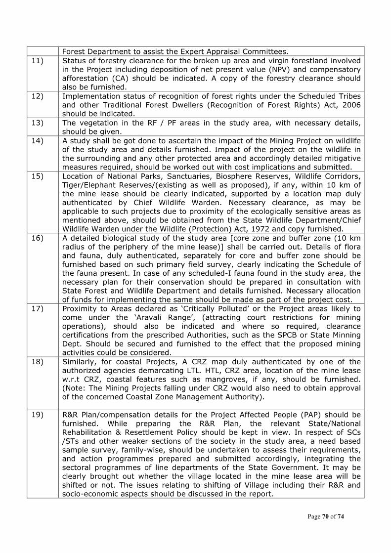
Page 70 of 74
Forest Department to assist the Expert Appraisal Committees. 11) Status of forestry clearance for the broken up area and virgin forestland involved
in the Project including deposition of net present value (NPV) and compensatory afforestation (CA) should be indicated. A copy of the forestry clearance should also be furnished.
12) Implementation status of recognition of forest rights under the Scheduled Tribes and other Traditional Forest Dwellers (Recognition of Forest Rights) Act, 2006 should be indicated.
13) The vegetation in the RF / PF areas in the study area, with necessary details, should be given.
14) A study shall be got done to ascertain the impact of the Mining Project on wildlife of the study area and details furnished. Impact of the project on the wildlife in the surrounding and any other protected area and accordingly detailed mitigative measures required, should be worked out with cost implications and submitted.
15) Location of National Parks, Sanctuaries, Biosphere Reserves, Wildlife Corridors, Tiger/Elephant Reserves/(existing as well as proposed), if any, within 10 km of the mine lease should be clearly indicated, supported by a location map duly authenticated by Chief Wildlife Warden. Necessary clearance, as may be applicable to such projects due to proximity of the ecologically sensitive areas as mentioned above, should be obtained from the State Wildlife Department/Chief Wildlife Warden under the Wildlife (Protection) Act, 1972 and copy furnished.
16) A detailed biological study of the study area [core zone and buffer zone (10 km radius of the periphery of the mine lease)] shall be carried out. Details of flora and fauna, duly authenticated, separately for core and buffer zone should be furnished based on such primary field survey, clearly indicating the Schedule of the fauna present. In case of any scheduled-I fauna found in the study area, the necessary plan for their conservation should be prepared in consultation with State Forest and Wildlife Department and details furnished. Necessary allocation of funds for implementing the same should be made as part of the project cost.
17) Proximity to Areas declared as ‘Critically Polluted’ or the Project areas likely to come under the ‘Aravali Range’, (attracting court restrictions for mining operations), should also be indicated and where so required, clearance certifications from the prescribed Authorities, such as the SPCB or State Minning Dept. Should be secured and furnished to the effect that the proposed mining activities could be considered.
18) Similarly, for coastal Projects, A CRZ map duly authenticated by one of the authorized agencies demarcating LTL. HTL, CRZ area, location of the mine lease w.r.t CRZ, coastal features such as mangroves, if any, should be furnished. (Note: The Mining Projects falling under CRZ would also need to obtain approval of the concerned Coastal Zone Management Authority).
19) R&R Plan/compensation details for the Project Affected People (PAP) should be furnished. While preparing the R&R Plan, the relevant State/National Rehabilitation & Resettlement Policy should be kept in view. In respect of SCs /STs and other weaker sections of the society in the study area, a need based sample survey, family-wise, should be undertaken to assess their requirements, and action programmes prepared and submitted accordingly, integrating the sectoral programmes of line departments of the State Government. It may be clearly brought out whether the village located in the mine lease area will be shifted or not. The issues relating to shifting of Village including their R&R and socio-economic aspects should be discussed in the report.

Page 71 of 74
20) One season (non-monsoon) primary baseline data on ambient air quality (PM10, SO2 and NOx), water quality, noise level, soil and flora and fauna shall be collected and the AAQ and other data so compiled presented date-wise in the EIA and EMP Report. Site-specific meteorological data should also be collected. The location of the monitoring stations should be such as to represent whole of the study area and justified keeping in view the pre-dominant downwind direction and location of sensitive receptors. There should be at least one monitoring station within 500 m of the mine lease in the pre-dominant downwind direction. The mineralogical composition of PM10, particularly for free silica, should be given.
21) Air quality modelling should be carried out for prediction of impact of the project on the air quality of the area. It should also take into account the impact of movement of vehicles for transportation of mineral. The details of the model used and input parameters used for modelling should be provided. The air quality contours may be shown on a location map clearly indicating the location of the site, location of sensitive receptors, if any, and the habitation. The wind roses showing pre-dominant wind direction may also be indicated on the map.
22) The water requirement for the Project, its availability and source should be furnished. A detailed water balance should also be provided. Fresh water requirement for the Project should be indicated.
23) Necessary clearance from the Competent Authority for drawl of requisite quantity of water for the Project should be provided.
24) Description of water conservation measures proposed to be adopted in the Project should be given. Details of rainwater harvesting proposed in the Project, if any, should be provided.
25) Impact of the project on the water quality, both surface and groundwater should be assessed and necessary safeguard measures, if any required, should be provided.
26) Based on actual monitored data, it may clearly be shown whether working will intersect groundwater. Necessary data and documentation in this regard may be provided. In case the working will intersect groundwater table, a detailed Hydro Geological Study should be undertaken and Report furnished. Necessary permission from Central Ground Water Authority for working below ground water and for pumping of ground water should also be obtained and copy furnished.
27) Details of any stream, seasonal or otherwise, passing through the lease area and modification / diversion proposed, if any, and the impact of the same on the hydrology should be brought out.
28) Information on site elevation, working depth, groundwater table etc. Should be provided both in AMSL and bgl. A schematic diagram may also be provided for the same.
29) A time bound Progressive Greenbelt Development Plan shall be prepared in a tabular form (indicating the linear and quantitative coverage, plant species and time frame) and submitted, keeping in mind, the same will have to be executed up front on commencement of the project.
30) Impact on local transport infrastructure due to the Project should be indicated. Projected increase in truck traffic as a result of the Project in the present road network (including those outside the Project area) should be worked out, indicating whether it is capable of handling the incremental load. Arrangement for improving the infrastructure, if contemplated (including action to be taken by other agencies such as State Government) should be covered.
31) Details of the onsite shelter and facilities to be provided to the mine workers
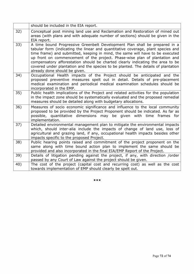
Page 72 of 74
***
should be included in the EIA report.
32) Conceptual post mining land use and Reclamation and Restoration of mined out areas (with plans and with adequate number of sections) should be given in the EIA report.
33) A time bound Progressive Greenbelt Development Plan shall be prepared in a tabular form (indicating the linear and quantitative coverage, plant species and time frame) and submitted, keeping in mind, the same will have to be executed up front on commencement of the project. Phase-wise plan of plantation and compensatory afforestation should be charted clearly indicating the area to be covered under plantation and the species to be planted. The details of plantation already done should be given.
34) Occupational Health impacts of the Project should be anticipated and the proposed preventive measures spelt out in detail. Details of pre-placement medical examination and periodical medical examination schedules should be incorporated in the EMP.
35) Public health implications of the Project and related activities for the population in the impact zone should be systematically evaluated and the proposed remedial measures should be detailed along with budgetary allocations.
36) Measures of socio economic significance and influence to the local community proposed to be provided by the Project Proponent should be indicated. As far as possible, quantitative dimensions may be given with time frames for implementation.
37) Detailed environmental management plan to mitigate the environmental impacts which, should inter-alia include the impacts of change of land use, loss of agricultural and grazing land, if any, occupational health impacts besides other impacts specific to the proposed Project.
38) Public hearing points raised and commitment of the project proponent on the same along with time bound action plan to implement the same should be provided and also incorporated in the final EIA/EMP Report of the Project.
39) Details of litigation pending against the project, if any, with direction /order passed by any Court of Law against the project should be given.
40) The cost of the project (capital cost and recurring cost) as well as the cost towards implementation of EMP should clearly be spelt out.

Page 73 of 74
Annexure-II
List of Participants
1. Shri M.S. Nagar Chairman 2. Dr. S. Subramaniyan Member 3. Dr. L Ajay Kumar Member 4. Dr. S.K. Peshin Member 5. Prof. G.S. Roonwall Member 6. Sri P.K. Verdia Member 7. Prof. A. K. Bhatnagar Member 8. Dr. Asha Rajvanshi Member 9. Dr. Saroj Director, MoEF Member Secretary 10. Dr. R. B. Lal, Deputy Director, MoEF 11. Dr. Sonu Singh, Deputy Director, MoEF 12. Representative of M/s Ravi Seelamsetty 13. Representative of M/s Lafarge India Pvt Ltd. 14. Representative of M/s Ultra Tech Cement Ltd. 15. Representative of M/s Bonai Industrial Co.Ltd. 16. Representative of M/s Feegrade & Co. (P) ltd. 17. Representative of M/s K.P. Cement 18. Representative of M/s Prabhudas Vithaldas 19. Representative of M/s Jharkhand State Mineral Development
Corporation Ltd. 20. Representative of M/s Eastern Coalfields Ltd. 21. Representative of M/s Ashapura Minechem Ltd. 22. Representative of M/s TATA Steel Ltd. 23. Representative of M/s Karan Minerals 24. Representative of M/s Vinira Minerals 25. Representative of M/s Prabhudas Vithaldas Makhecha 26. Representative of M/s Essel Mining & Industries Ltd. 27. Representative of M/s Kariganur Iron & Steel Pvt. Ltd. 28. Representative of M/s Om Ganesh Minerals 29. Representative of M/s Wonder Cement Ltd. 30. Representative of M/s Calcom Cement India Ltd. 31. Representative of M/s Hindustan Copper Ltd. 32. Representative of M/s J.K. Lakshmi Cement Ltd. 33. Representative of M/s Shri Abhishek Choudhary 34. Representative of M/s Mahendra Singh Ratnawat 35. Representative of M/s Chandak Associates 36. Representative of M/s Kuber Associates 37. Representative of M/s Shekhawat Associates 38. Representative of M/s Surya Associates 39. Representative of M/s Rahul Panwar 40. Representative of M/s Shri Anil Joshi 41. Representative of M/s Abhimanyu Choudhary
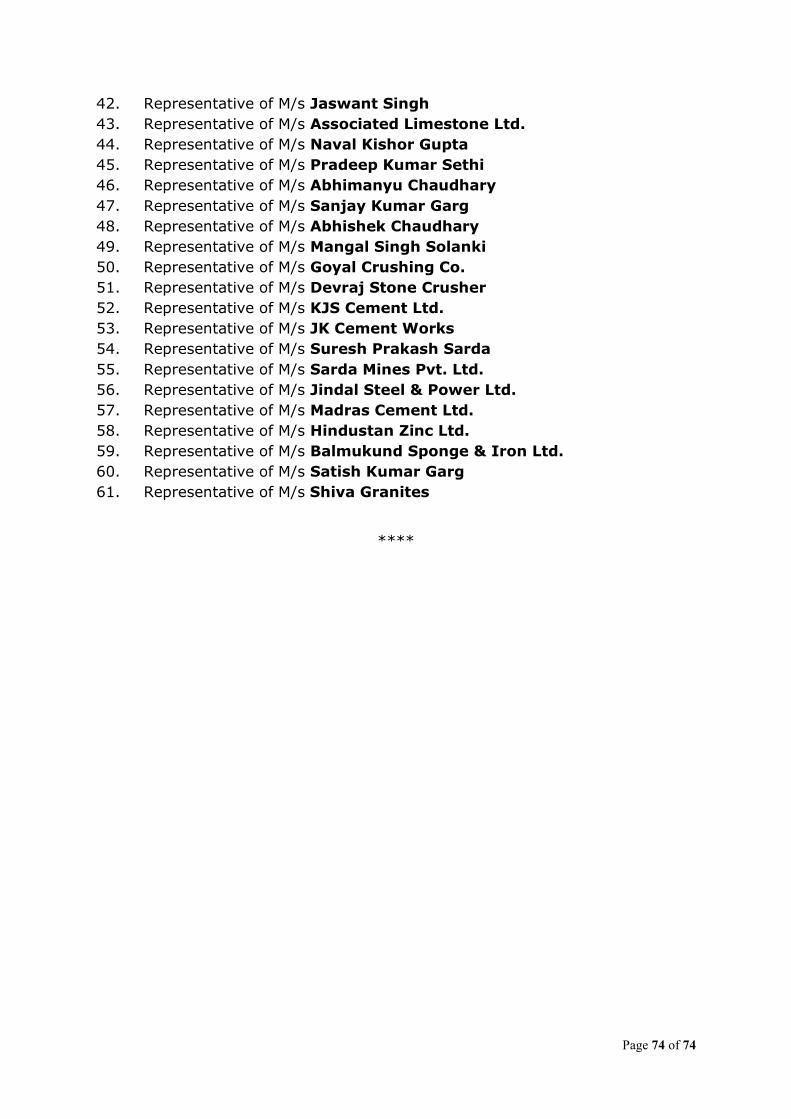
Page 74 of 74
42. Representative of M/s Jaswant Singh 43. Representative of M/s Associated Limestone Ltd. 44. Representative of M/s Naval Kishor Gupta 45. Representative of M/s Pradeep Kumar Sethi 46. Representative of M/s Abhimanyu Chaudhary 47. Representative of M/s Sanjay Kumar Garg 48. Representative of M/s Abhishek Chaudhary 49. Representative of M/s Mangal Singh Solanki 50. Representative of M/s Goyal Crushing Co. 51. Representative of M/s Devraj Stone Crusher 52. Representative of M/s KJS Cement Ltd. 53. Representative of M/s JK Cement Works 54. Representative of M/s Suresh Prakash Sarda 55. Representative of M/s Sarda Mines Pvt. Ltd. 56. Representative of M/s Jindal Steel & Power Ltd. 57. Representative of M/s Madras Cement Ltd. 58. Representative of M/s Hindustan Zinc Ltd. 59. Representative of M/s Balmukund Sponge & Iron Ltd. 60. Representative of M/s Satish Kumar Garg 61. Representative of M/s Shiva Granites
****