the abbey of the dunes (koksijde) and noordduinen: … · the abbey of the dunes (koksijde) and...
TRANSCRIPT
Herrier J.-L., J. Mees, A. Salman, J. Seys, H. Van Nieuwenhuyse and I. Dobbelaere (Eds). 2005. p. 463-474 Proceedings ‘Dunes and Estuaries 2005’ – International Conference on Nature Restoration Practices in European Coastal Habitats, Koksijde, Belgium, 19-23 September 2005 VLIZ Special Publication 19, xiv + 685 pp.
- 463 -
The Abbey of the Dunes (Koksijde) and Noordduinen: the environmental link restored
Siska Van de Steene1, Carole Ampe1, Klaas De Smet1 and Wim Pauwels2
1 Vlaamse Landmaatschappij, West-Vlaanderen Velodroomstraat 28, B-8200 Brugge, Belgium E-mail: [email protected]
2 Nature Division, Ministry of the Flemish Community Zandstraat 255 b3, B-8200 Sint-Andries, Belgium
Abstract
The Abbey of the Dunes (Ten Duinen) at Koksijde, founded in the 12th century and abandoned around 1600, forms the subject of a land use planning project realized by the Flemish Land Agency (Vlaamse Landmaatschappij). Initially the project focussed on the museum and the integration of the abbey ruins in an open-air museum. However the site presented an opportunity to involve the Noordduinen, bordering on the abbey park, in a nature restoration project. The key intention was to restore the landscape connection between the abbey and the dunes, as it was in the Middle Ages. The proposed actions consist of breaking up a road, deviation of the traffic, upgrading the abbey park and start of a nature restoration project in the Noordduinen. The main bottlenecks were deviation of the traffic, excavation and preservation of archaeological finds and intensive recreational use of the Noordduinen. Continuous consultation and deliberation with all involved authorities and with the local inhabitants of Koksijde resulted in a plan supported by the majority of the community.
Keywords: Koksijde; Nature restoration; Recreation; Archaeology; Spatial consolidation.
Introduction
The site of the Abbey of the Dunes (Ten Duinen) including ruins of the abbey, museum and park and the dunes of the Noordduinen cover 115ha between the urbanization of Koksijde-dorp, Koksijde-Bad and Sint-Idesbald. Military infrastructure of the Belgian air forces (Kwartier Basis Adjudant Vlieger F. Allaeys) is located in the south. The area is also criss-crossed by three busy roads (Van Buggenhoutlaan, Leopold III laan, Robert Van Dammestraat) (Fig. 1). The Noordduinen and the Abbey of the Dunes have exceptional historical, ecological and recreational values, therefore they enjoy protection under different legislations. More than 90% of the area is designated as nature area by the Law on the Organization of Town and Country Planning (1962). The decree of Monuments and Landscapes of Cities and Villages (1986) protects the archaeological site of the Abbey of the Dunes. The non-built-up area within the military domain is protected by the Decree on

S. Van de Steene et al.
- 464 -
Protection of the Coastal dunes (1993). Furthermore the dunes are designated as SAC (Spatial Area of Conservation) under the EEC Habitat directive (92/43/EEG). Since 1999 a plan was conceived to upgrade and reintegrate the ruins of the Abbey of the Dunes and its surroundings. The realization of the plan involved different aspects, such as history and culture, ecology and recreation. This paper elaborates on the start and the course of the plan and the encountered difficulties.
Fig. 1. Localisation of the Abbey of the Dunes and Noordduinen (C: Camping; S: School;
AB: Army Base; MC: Military Cemetery).
The Abbey of the Dunes (Koksijde) and Noordduinen
- 465 -
Historical review of the abbey site
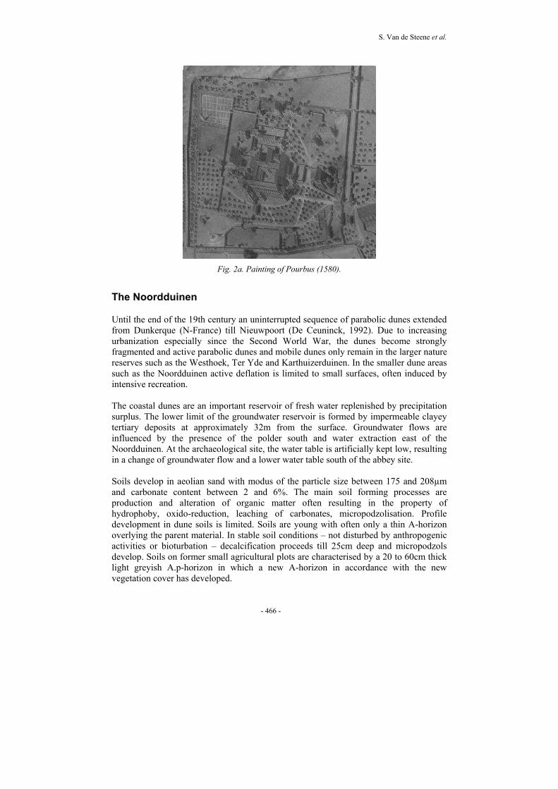
In 1107, Ligurius, a French hermit settled in the dunes northwest of the modern community of Koksijde-dorp. He was soon joined by congenials and they organised themselves according to the rules of Benedictus. In 1128 they established a first abbey in wood amidst the dunes on land, which was a gift from the earl of Flanders. In 1138 the abbey sought association with the Cistercian order (De Boer et al., 1989). The abbey played a leading role in the development of the region, but the agricultural–economical strategies of the abbey deviated substantially from tradition and rules of the Cistercian order. During the following 150 years acquisitions, gifts and exchanges of land lead to the establishment of vast grangiae. Besides the Abbey of the Dunes, many farms were leased to and managed by civilians (Termote, 1992). At Koksijde the construction of a new abbey started in 1214. This was the first complex of brick buildings constructed in Flanders. The gothic church measured 117m long. At circa 1300 the abbey is at the height of its power with 120 monks and 248 lay brothers and the estate of the abbey amounted up to 10,000ha (Van Royen, 2003). From 1400 onwards a gradual decline started: unfavourable political circumstances, large debts and a decrease of vocations were the main causes. Because of its localisation amidst the dunes, the abbey suffered problems from an increasing mobility of parabolic dunes and rising groundwater. At first it was possible to slow down the progression of the parabolic dunes by plantation. Soon however a large mobile dune developed which became very difficult to control. From the end of the 15th century onwards plans were made to relocate the abbey. The map of Pieter Pourbus (Fig. 2a) from 1560 shows the abbey and its environment, its aim was to depict the abbey as exact as possible in order to reconstruct it elsewhere. The threatening dunes are clearly visible on the northwestern side. The position of the abbey was weakened by the ‘War of Religions’ (between Protestants and Catholics 1566 – 1648) and the problems with the mobile dune could not be counteracted anymore. The dune, “Hoge Blekker”, covered the ruins of the abbey completely in the 17thcentury. The monks finally founded a new abbey in Bruges in 1627, partially constructed with recuperated materials from the Abbey of the Dunes (Termote, 1992). In 1949 excavations started on the site and the discoveries were remarkable: the church, cloister arcade, lavatory and refectory were recovered. The foundations of the buildings were still intact. The discoveries were consolidated with the techniques available at the time and put on display for the public. During the same period, part of the abbey disappeared under a newly constructed road (Van Buggenhoutlaan). This road severed the historical link between the abbey site and the dunes. An archaeological park and a very attractive and modern museum was constructed. However, by lack of new investments, the exhibition became outdated, the ruins of the abbey and the park fell into decay and eventually the museum closed its doors in 1998.
S. Van de Steene et al.
- 466 -
Fig. 2a. Painting of Pourbus (1580).
The Noordduinen
Until the end of the 19th century an uninterrupted sequence of parabolic dunes extended from Dunkerque (N-France) till Nieuwpoort (De Ceuninck, 1992). Due to increasing urbanization especially since the Second World War, the dunes become strongly fragmented and active parabolic dunes and mobile dunes only remain in the larger nature reserves such as the Westhoek, Ter Yde and Karthuizerduinen. In the smaller dune areas such as the Noordduinen active deflation is limited to small surfaces, often induced by intensive recreation. The coastal dunes are an important reservoir of fresh water replenished by precipitation surplus. The lower limit of the groundwater reservoir is formed by impermeable clayey tertiary deposits at approximately 32m from the surface. Groundwater flows are influenced by the presence of the polder south and water extraction east of the Noordduinen. At the archaeological site, the water table is artificially kept low, resulting in a change of groundwater flow and a lower water table south of the abbey site. Soils develop in aeolian sand with modus of the particle size between 175 and 208µm and carbonate content between 2 and 6%. The main soil forming processes are production and alteration of organic matter often resulting in the property of hydrophoby, oxido-reduction, leaching of carbonates, micropodzolisation. Profile development in dune soils is limited. Soils are young with often only a thin A-horizon overlying the parent material. In stable soil conditions – not disturbed by anthropogenic activities or bioturbation – decalcification proceeds till 25cm deep and micropodzols develop. Soils on former small agricultural plots are characterised by a 20 to 60cm thick light greyish A.p-horizon in which a new A-horizon in accordance with the new vegetation cover has developed.
The Abbey of the Dunes (Koksijde) and Noordduinen
- 467 -
The main habitats are ‘grey dune’ (moss dunes and dune grasslands), humid dune slacks, dunes with Salix repens, dunes with Hippophae rhamnoides and dune forest. Open dunes with Ammophila arenaria ('white dunes') cover small scattered areas. Grey dunes are designated as priority habitat in the Annex I of the EU Habitat Directive and deserve special conservation attention (Provoost et al., 2004). For the Flemish west coast, the species richness of the dune grasslands is one of the highest in the Noordduinen (Janssens, 2000 in Provoost and Bonte, 2004): rare chalk grassland species, such as Thesium humifusum, Asperula cynanchica, Polygala vulgaris, also included in the Red List, are well represented within the Noordduinen.
Land-use planning and nature restoration by the Flemish Land Agency (FLA - Vlaamse Landmaatschappij) at Koksijde
The municipality of Koksijde counts about 20,000 inhabitants and as a coastal community its economic activities are mainly geared towards tourism. Summer months are usually very busy and weekend tourism is on the increase. So-called “all-weather-activities” become more important as an attraction pool for tourists. Koksijde became conscious of the tourist value of the dune abbey site and requested the FLA to cooperate with the project to restore the site of the Abbey of the Dunes. Within the FLA a team was established to study the site of the Abbey of the Dunes and its wider spatial context. It is a multi-disciplinary group, which studies the different aspects such as environment (fauna and flora, hydrology, pedology and geomorphology), recreation and archaeology. For each aspect an inventory, an analysis of the bottlenecks and a view was formulated. Next a comprehensive strategy was determined in which the different disciplines fit. In a first phase a land use planning project for the abbey site, aiming at the integration and sustainable development of different land-use aspects such as culture, history, environment and recreation was established. Such projects are characterised by a holistic approach based on in-depth studies of all aspects, which shape the area. Because of its spatial position, bordering on the Noordduinen and caught between the urbanization of Koksijde-Dorp, Koksijde-Bad and St-Idesbald, it was soon decided to involve the surrounding Noordduinen in a nature restoration project. This approach would ensure a consolidation of the fragmented dune area and an integration of the abbey in its original landscape.
The project of the dune abbey
Analysis of the area
In the past the abbey was a very important agricultural and economic centre in the area. Through the archaeological excavations one can imagine the grandeur and significance of the Medieval abbey. In Medieval times the use of the dunes as grazing area contributed to the prosperity of the Abbey of the Dunes, but later on the dunes formed one of the causes of the decline of the abbey.
S. Van de Steene et al.
- 468 -
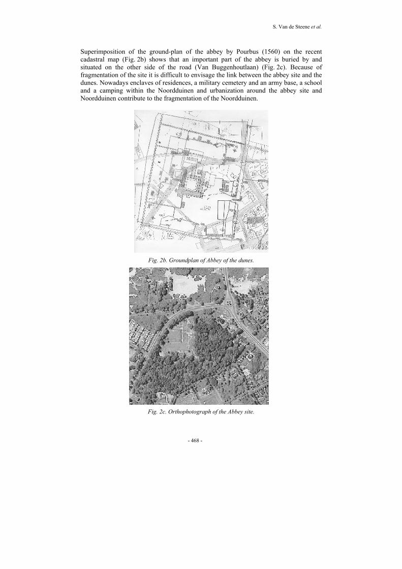
Superimposition of the ground-plan of the abbey by Pourbus (1560) on the recent cadastral map (Fig. 2b) shows that an important part of the abbey is buried by and situated on the other side of the road (Van Buggenhoutlaan) (Fig. 2c). Because of fragmentation of the site it is difficult to envisage the link between the abbey site and the dunes. Nowadays enclaves of residences, a military cemetery and an army base, a school and a camping within the Noordduinen and urbanization around the abbey site and Noordduinen contribute to the fragmentation of the Noordduinen.
Fig. 2b. Groundplan of Abbey of the dunes.
Fig. 2c. Orthophotograph of the Abbey site.
The Abbey of the Dunes (Koksijde) and Noordduinen
- 469 -
Fragmentation of the Flemish coastal dunes leads to smaller and more isolated areas and obstructs dynamic geomorphological processes typical for the dune environment. Habitat fragmentation decreases survival chances of rare populations as dispersal of seeds and migration of fauna become difficult. The Noordduinen located between Belvedere (dune-polder transition) and Houtsaegerduinen nature reserves in the west and the dune complex of the Hoge Blekker – Doornpanne nature reserve in the east, form an indispensable spatial link (Econnection, 2000) between remaining dune areas. The absence of any form of nature management causes a degradation of the moss dunes and the dune grasslands suffer from shrub invasion. Several ‘exotic’ species cause the deterioration of the typical vegetations. Locally strong wood expansion occurs due to seedlings of Poplars (Populus x euramericana) planted for dune fixation and of Maple tree (Acer pseudoplatanus). Migration from gardens and deposition of green waste result in the spreading of aggressive plant species such as Mahonia (Mahonia aquifolium) and White poplar (Populus alba) which replace indigenous plant species. In addition internal degradation of the grey dunes occurs through grass encroachment. These processes result in a decrease of the quality of the grey dunes and an evolution towards a less specific flora resulting in a decline in biodiversity (Provoost et al., 2004). The disappearance of moss dune vegetation and dune grasslands has a negative effect on the bird species (Saxicola torquata), insects of open spaces (Oedipoda caerulescens) and butterflies (Issoria lathonia). A special landscape element typical for the Noordduinen are the old fisherman’s houses and their small fields. These originate from the 18th century when fishermen supplemented their income by growing potatoes and rye. The fields were often laid out in levelled dune slacks and enclosed by wooded banks. Nowadays, many of these small pastures are intensively used as horse paddocks. They are overgrazed, heavily trampled and manured and of poor botanical quality. The horses cause severe damage to the wooded banks grown with Common alder (Alnus glutinosa). Recreation is an important activity within the Noordduinen. Although no quantitative data on recreational use of the area are available, it is clear that the present recreation in the Noordduinen leads to disturbance and treading. Especially moss dune, pioneer vegetation of dune slacks and dune grassland are very sensible to treading. Horse riding, mountain biking, cyclo-cross cause a lot of damage to vegetation and soil. Walking trails and horse routes are often not well indicated and many paths occur. Stray dogs disturb wildlife and littering (paper, refuse, garden waste, building materials,…) is a problem throughout the area. Last but not least there is the annual Belgian cyclo-cross Championship which causes soil and vegetation damage, not so much by the cyclists but mainly by the many spectators and ‘wannabe champions’. Finally there is a lack of a scientifically founded management plan that takes into account the actual bearing capacity of the land and the objectives of nature restoration.
S. Van de Steene et al.
- 470 -
Objectives for restoration of the abbey site and Noordduinen The bottlenecks described above indicate that the problems require adequate and swift solutions. The actions to be taken, should concentrate on the conservation and restoration of historical and ecological values of the area. Recreational use and educational facilities can be developed as well. The abbey site, completely run down by the end of the nineties, could be developed by a land-use planning project. Its main objective is the development of abbey site as an attraction point for the inhabitants of Koksijde and the many tourists. The removal of the road Van Buggenhoutlaan will allow archaeological research on the additional part of the abbey. The interdisciplinary approach will improve the knowledge on the monastic living environment from the 13th to 16th century. The extension of the abbey site towards the Noordduinen will restore the original glory of the Medieval abbey and the link between the abbey and the dunes will be re-established. The development of the Noordduinen forms the subject of the nature restoration project Noordduinen. The policy of the Flemish government is to safeguard all remaining dune areas. It aims at conservation and restoration of specific environmental dune environments, to stimulate biodiversity by conservation of typical dune flora and fauna communities (De Pue et al., 2002). The ecosystem vision on coastal dunes of the Flemish government (Provoost and Hoffmann, 1996) proposes for the Noordduinen a semi-natural landscape. In such areas preservation and/or expansion of specific succession stages on rather small scale is the main purpose. The project wants to strengthen the nature values especially the moss dunes and dune grasslands. The biggest challenge is to find a balance between ecological potentials, historical values and recreational use. The planning and realization of a project whereby very diverse interests and different pressure groups agree on a common strategy will be the main task. Obtaining wide support by all parties involved and by the general public will be a major achievement. At the moment the land-use planning project is under implementation. The project “I rise again from beneath the sand” launched by the municipality, aimed at a cultural-historical valorisation of the entire former abbey site. An integrated concept of museum, park and dunes was designed. The very attractive museum uses a new concept with modern presentation techniques. An ecological park-forest, in which the structure of the abbey is visualized, incorporates a remnant of dune grassland situated to the north of the site. The excavations and reconstruction of historical elements of the ruins take into account the recommendations of the Charter of Venice (1964). As such, the foundations of the church were reconstructed by using an uniformity of building materials. The next phase of the project concerns the removal of the Van Buggenhoutlaan. Not only the breaking up of the road is investigated but a multi-modal traffic study had to formulate solutions for the future traffic flows. From the study it was clear that most of the traffic could be deviated along the Ter Duinenlaan. Because this road runs through a residential area it is necessary to rebuild the road. Thereafter the Van Buggenhoutlaan can be broken up and the extension of the park can proceed.
The Abbey of the Dunes (Koksijde) and Noordduinen
- 471 -
Reconciliation of nature, history and recreation in the Noordduinen nature restoration project Nature restoration projects put the main emphasis on nature development. In the Noordduinen the actions involve habitat restoration as well as the introduction of different management regimes. Habitat restoration activities are very diverse and include removal of poplar plantations, removal of shrubs, removal of exotic plant species such as Mahonia aquifolium, strengthening of small landscape elements e.g. making drinking pools and restoration of wooded banks bordering the 19th century agricultural fields, removal of the nutrient rich surface horizon, clearing of a dune slack to set back the succession, reshape the microrelief on former intensively used fields, introduction of mowing and grazing. Recreation in Noordduinen occurs under many different forms such as the pure experience of the natural environment with specific interests for flora and fauna to very active sports with little affinity for nature and landscape. In the first case nature stands at the centre of the activity, in the latter case the action itself is the main objective e.g. jogging, mountain biking, geocaching, quad riding, cyclo-cross… and although the scene is very agreeable the activity could be easily relocated to e.g. recreational areas with proper facilities. In between these two types of activities, an intermediate group of dune users enjoy walking (whether or not accompanied by dog), pick-nicking, horse riding... For them, the main attraction of the dunes are landscape qualities such as scenery, attractiveness and tranquillity. Activities such as walking are perfectly reconciliatory with the aims of nature restoration. Other activities such as sun bathing which are not at all nature-oriented, do little harm to the ecological values of the area. Indeed, it has now been recognized that light recreation pressure can be beneficial in dune areas by supplementing rabbit grazing (Rooney and Houston, 1998). As it happens in Noordduinen some rare plant species such as Large thyme (Thymus pulegioides), Common milkwort (Polygala vulgaris), Common rock-rose (Helianthemum nummularium) occur along stray paths. The more active forms of recreation, like mountain biking, are much more difficult to reconcile with the aims of nature conservation, especially when they occur very dispersed over the area (Provoost and Hoffmann, 1996). In spite of the protection of the largest part of the Noordduinen under the Law on the Organization of Town and Country Planning (1962) and the designation as SAC (Spatial Area of Conservation) under the EEC Habitat directive (1992) no management plan nor a code of conduct has been drawn up for the area. This has led to an intensive recreational use of the dunes and many activities have obtained the status of ‘acquired rights’. As such it was not an option nor desirable to exclude recreation in the Noordduinen. The proposals of the nature restoration project took into account the carrying capacity of the dunes and the compatibility with future management. The choice was made to canalize and/or to relocate as much as possible the different recreational users. As a consequence some restrictions on recreational use had to be introduced. This has been a deliberate choice as it is not obvious that part of the ‘nature’ budget is used for recreation.

S. Van de Steene et al.
- 472 -
Nature restoration sometimes involves ground-works. These types of works are not at all appreciated by archaeologists who fear the damage or destruction of archaeological features in the soil archive. Especially ground-works which cover large areas such as the removal of a nutrient rich surface horizon or changing the microrelief on former agricultural fields form a very sensitive point for archaeologists and they wish to reduce these types of works as much as possible. Although in land use planning and nature restoration projects the FLA often implements a culture-historical study of the project area, budgets are often too limited to allow detailed archaeological prospecting, not to mention the financing of a complete archaeological excavation. So even nature restoration can destroy valuable sites and it is important to take this risk into account from the planning phase onwards. In most cases archaeologists can predict these chances, but they can never be totally sure, except when the soil has been disturbed before. In spite of these dangers, contemporary archaeological administration is not actively involved in the different phases of spatial planning. They prefer to focus their attention on ongoing ground-works but a certain involvement in the planning phase would be desirable.
Consultation process
In the restoration project of the abbey site the break up of the ‘Van Buggenhoutlaan’ road formed the most important bottleneck. It was necessary to convince the different authorities, in particular the municipality of Koksijde. Once the municipality agreed to remove the road, consultancy meetings were organised with the Roads department, Nature division, division of Monuments and Landscapes of the Ministry of the Flemish community, the Institute for the Archaeological Heritage of the Flemish Community (VIOE). Furthermore there are different advisory authorities with a say in the matter. Finally the members of the public are also involved and during a public hearing objections on the plan can be raised. If relevant these suggestions are incorporated into the plan. On advice of the committee of the project and on request, emerging from the public inquiry, a bicycle path between the extended abbey park and Noordduinen was taken up in the plan. The procedure of nature restoration project Noordduinen provides for different ways of public’s participation through representatives in a commission and a committee but most importantly through public hearings. However to formulate a well founded nature restoration plan in which some facilities for recreation had to be accommodated, the project team had to identify representative spokespersons. In the case of horse riding, consultation with the three riding schools of Koksijde resulted in an acceptable compromise. For mountain biking or cyclo-cross (except for the annual race) the lack of any organisational structure makes consultation very difficult. Especially in winter the entire area is used on a frequent basis by individual bikers. Finally cooperation was sought with the sports official of the community of Koksijde to work out an acceptable track for both parties. Other activities such as squad riding and motor biking have been banned from the dunes. Conflicts with archaeologists are not always easy to resolve. In the case of the Noordduinen, we know exactly where the abbey is situated. For the other historical

The Abbey of the Dunes (Koksijde) and Noordduinen
- 473 -
periods, there is a gap in our knowledge about the past and it is more difficult to locate potential archaeological sites. Archaeologists question if groundwork is the only option to reach specific habitat requirements because they wish to conserve the soil archive as intact as possible. So far the agreement reached is that the archaeologists will follow up the ground-works reaching deeper than the plough-layer (or deeper than the A-horizon in young sandy soils in this case). When any archaeological finds are exposed by ground-works, one should evaluate their importance and decide whether or not to excavate before allowing the works to continue or to halt the ground-works altogether.
Conclusions
The project of the Abbey of the Dunes has proven that it can be important to include larger parts of the environment than the historical site only. Such an approach needs a more comprehensive strategy but leads to a better integration of the different interests. Due to a smooth cooperation between the different study fields it was possible to develop a plan that all parties could agree upon. As the plan is the result of much deliberation and consultation with many different disciplines and the public, it is supported by the majority of the community. The realization of the three phases of the project Abbey of the Dunes increases the quality of the environment and integrates an archaeological monument into the present situation.
References
De Boer D., J. van Herwaarden and J. Scheurkogel. 1989. Middeleeuwen. Wolters-Noordhoff, Groningen. 457p.
De Ceuninck R. 1992. Het duinlandschap: ontstaan en evolutie. p.18-45. In: Tussen Land en Zee. Termote J. (Ed.). Lannoo. 264p.
De Pue E., L. Lavrysen and P. Stryckers. 2002. Milieuzakboekje. Kluwer, Diegem, 1013p.
Econnection. 2000. Geïntegreerd kustzonebeheer. Deel I. Gebiedsvisie van het gebied tussen de Franse grens en de Westende. Studie in opdracht van ministerie van de Vlaamse gemeenschap, AWZ-WWK. 124p.
Janssens B. 2000. Verspreiding en auto-ecologie van enkele zeldzame en duinspecifieke plantensoorten aan de Vlaamse Westkust. Ongepubliceerde licentiaatsverhandeling. Universiteit Gent. 120p.
Provoost S. and M. Hoffmann (Eds). 1996. Ecosysteemvisie voor de Vlaamse Kust. Studie in opdracht van ministerie van de Vlaamse gemeenschap, AMINAL, afdeling Natuur. I. Ecosysteembeschrijving. 375p. Bijlagen II. Natuurontwikkeling. 130p.
Provoost S., C. Ampe, D. Bonte, E. Cosyns and M. Hoffmann. 2004. Ecology, management and monitoring of grey dunes in Flanders. Journal of Coastal Conservation 10:33-42.
Rooney P. and J.A. Houston. 1998. Management of dunes and dune heaths; experience on the Sefton coast, north west England. p.121-129. In: Ovesen C.H. (Ed.). Coastal Dunes – Management, Protection and Research. Report from a European Seminar, Skagen, Denmark, August 1997. Danish National Forest and Nature Agency and the Geological Survey of Denmark and Greenland, Copenhagen.

S. Van de Steene et al.
- 474 -
Termote J. 1992. Wonen op het duin. De bewoningsgeschiedenis van het duingebied tot aan de Franse Revolutie. p.46-87. In: Termote J. (Ed.). Tussen Land en Zee. Lannoo. 264p.
Van Royen H. 2003. De abdij Ten Duinen in Koksijde: een groeipool in het middeleeuwse graafschap Vlaanderen. Openbaar kunstbezit in Vlaanderen 2003(2):3-4.
VLM West-Vlaanderen. 2001. Landinrichtingsproject De Westhoek – Deelproject De duinen; Inrichtingsplan De Duinenabdij. Brugge.
VLM West-Vlaanderen. 2003. Landinrichtingsproject De Westhoek – Deelproject De Duinen; Inrichtingsplan De Duinenabdij Fase 2. Brugge.
VLM West-Vlaanderen. 2003. Natuurinrichtingsproject Noordduinen – Projectrapport. Brugge http://www.tenduinen.be/pages/nederlands/mainpage_nl.htm, March 2003.