the architectural heritage of solikamsk and the … · the architectural heritage of solikamsk and...
TRANSCRIPT

Cahiers slaves, n° 10, UFR d’Études slaves, Université de Paris-Sorbonne, 2008, p. 317-355.
THE ARCHITECTURAL HERITAGE OF SOLIKAMSK
AND THE NORTHERN DISTRICTS OF PERM PROVINCE*
by
WILLIAM C. BRUMFIELD Tulane University, New Orleans, Louisiana
The Province of Perm, located at the center of the European side
of the Ural Mountains, is one of the most important economic, industrial, and cultural centers in contemporary Russia. Yet the city of Perm itself is a recent foundation, officially incorporated only in 1781. For the deeper historical legacy of this region one must explore the older settlements of Solikamsk and Cherdyn’, which played a pivotal role in the Russian settlement of the Ural Mountains and Siberia.
References to a territory known as "Perm" (apparently deriving from the Finno-Ugric words pera ma, meaning "distant land") appear as early as the twelfth-century chronicle Tale of Bygone Years.1 At that
* Dans cet article, la translittération des noms propres et mots russes est conforme à l’usage anglo-saxon. 1 The words pera ma have been derived from the language of the Veps, a Finno-Ugric people living between lakes Ladoga and Onega. The explanation has it that they would have used these words in response to questions by Novgorodian explorers about lands to the east. See A.S. Krivoshchekova-Gantman, Geograficheskie nazvaniia Verkhnego Prikam’ia (Perm, 1983), 134; and E.V. Shabashova, Istoricheskie miniatiury o Zemle Permskoi (Perm: "Kursiv", 1998), 13-16.

WILLIAM C. BRUMFIELD
318
time the word "Perm" was variously used to mean lands extending from the Vychegda River basin in the north to the Pechora and Izhma river networks in the east and south to the Vishera and Kama Rivers. All of these lands were explored by intrepid hunters and traders from the medieval Russian economic center of Novgorod, to whom these northern and eastern lands owed nominal allegiance. Novgorod’s primary interest in this area was its rich supply of valuable furs.2
By the fourteenth century the area extending from the Kama River into the central and northern Urals was referred to as "Perm the Great" (Perm’ velikaia) in certain chronicles and in the vita of Saint Stefan of Perm written by Epifanii the Wise (premudryi) in 1396.3 Saint Stefan’s missionary activities among northern indigenous peoples such as the Komi (or Zyrians) resulted in his canonization, although subsequent Russian exploitation of these peoples was anything but benign. Saint Stefan was born in the northern town of Velikii Ustiug (located at the confluence of the Sukhona and Iug Rivers), which not only became an important logistical center in support of the Russian move toward the east but also provides an early example of the web of connections between the culture of the Russian north and the developing cultures of the Russian east.4
During the fourteenth and early fifteenth centuries this territory remained under the nominal authority of Novgorod, but Moscow was closer to the area and by the middle of the fifteenth century began to promote its economic and territorial interests in the northeast. Among the earliest Russian settlements in the area was Solikamsk, apparently founded around 1430 by the Kalinnikovs, a wealthy merchant family from the northern town of Vologda who were intent on developing the
2 Evgenii N. Bubnov, Russkoe dereviannoe zodchestvo Urala (Moscow: Stroiizdat, 1988), 9. 3 A.A. Dmitriev, ed., Permskaia starina, vol. 1 (Perm, 1889), 68. 4 William C. Brumfield, "Sixteenth- and Seventeenth-Century Church Architecture in Vologda Province", in Biuletyn Historii Sztuki, 60 (1998) 1-2:36-37.
THE ARCHITECTURAL HERITAGE OF SOLIKAMSK AND THE NORTHERN DISTRICTS OF PERM PROVINCE
319
ample salt springs in the vicinity of the middle Kama River.5 Indeed, throughout the medieval period the Russian move into this densely forested part of the Urals was greatly facilitated by river networks, as had been the case in the settlement of the north.6
Before proceeding to a survey of the rich architectural ensemble of Solikamsk, we should note that the earliest center of Muscovite authority in the middle regions of the Urals was the settlement of Cherdyn’, situated on the right bank of the River Kolva, near its confluence with the Vishera.7 Inhabited perhaps as early as the ninth century, Cherdyn’ was well situated to control river passage in several strategic directions: to the north, via the Kolva, to the Pechora basin; to the south, via the Kama, to the Volga and Moscow; and to the east, via the Vishera, to the Ob River basin and Siberia.
Although earlier Russian historians had assumed that Moscow ruled this area through local, non-Russian vassals, recent research suggests that in 1451 Moscow grand prince Basil II sent Mikhail Ermolich, the son of a regional Muscovite prince, to rule the Cherdyn’ area in Moscow’s name.8 In the 1450s and 1460s a new wave of Orthodox missionary activity accompanied this move, which resulted in the construction of the first churches in the middle Urals and the
5 Georgii N. Chagin, Na drevnei Permskoi zemle (Moscow: "Iskusstvo," 1988), 10-11. See also Bubnov, Russkoe dereviannoe, p. 10; and V.V. Kostochkin, Cherdyn’. Solikamsk. Usol’e (Moscow, 1988). Some local historians have argued in support a later date for the founding of Solikamsk. See Gennadii Bordinskikh, Tainy istorii Permi velikoi (Solikamsk: Solikamskii Gosudarstvennyi kraevedcheskii muzei, 1994), 62-65. 6 For a pioneering western study of this process, see Robert Kerner, The Urge to the Sea: the Course of Russian History. The Role of Rivers, Portages, Ostrogs, Monasteries, and Furs (Berkeley: University of California Press, 1942). 7 Bubnov, Russkoe dereviannoe, p. 10. 8 See V.A. Oborin, Zaselenie i osvoenie Urala v kontse XI-nachale XVII veka (Irkutsk, 1990), 75. Oborin’s view, first advanced in the 1960s and now widely accepted, was based on a passage from the Vychegodsko-Vymskaia chronicle, published as "Vychegodsko-Vymskaia (Misailo-Evtikhievskaia) letopis’", in Istoriko-filologicheskii sbornik (Syktyvkar, 1958), 261. For further commentary see V.V. Mukhin, "Eshche raz o Permskikh kniaz’iakh", in S.A. Dimukhametova, et al., eds., Cherdyn’ i Ural v istoricheskom and kul’turnom nasledii Rossii (Perm’: Cherdynskii muzei, 1999), 104-06.
WILLIAM C. BRUMFIELD
320
establishment in Cherdyn’ of the area’s first monastery, dedicated to Saint John the Divine.9 However, the area, which was only lightly settled by Russians, remained vulnerable to attacks supported by the Kazan’ and Siberian khanates, causing Mikhail himself to waver in loyalty. Only in 1472, after Moscow’s subjugation of Novgorod, was Ivan III able to send an armed force gathered among northern towns and sent from Velikii Ustiug to reestablish Moscow’s control of the Cherdyn’ foothold in the Urals.10
Although Cherdyn’ was the area’s main settlement, the nearby outpost of Pokcha (also on the Kolva) was designated the regional administrative center.11 After a fire destroyed Pokcha’s log fort in 1535, Cherdyn’ was officially designated a town and became the administrative center of the large Perm territory, ruled by a voevoda. Ruthless frontier warfare continued to threaten Russian authority and Russian settlers in the area. For example, Solikamsk, Cherdyn’, and nearby settlements were subjected to devastating Nogai raids in January and May of 1547 that followed an unsuccessful Muscovite campaign in 1545 to stage an attack and incite a pro-Moscow coup within the court of the Kazan’ khanate.12 As a result of the May raid alone, perhaps as many as 1,100 Russian settlers were killed in the area from Solikamsk to Cherdyn’. Only with Ivan the Terrible’s conquest of Kazan’, in 1552, did the threat to the Cherdyn’ Perm territory lessen.
During the latter half of the sixteenth century, Cherdyn’ maintained the advantages of its favorable geographic position. In addition to river networks, the primary overland route over the Urals to western Siberia began in Cherdyn’ and caravans to the orient often wintered there. According to a census of 1579, Cherdyn’ had a population of 326 males, which suggests a total population of at least
9 Chagin, Na drevnei Permskoi, 11-12. 10 L.A. Titov, ed., Letopis’ Velikoustiuzhskaia (Moscow, 1889), 40. 11 Polnoe sobranie russkikh letopisei, vol. 12 (Moscow, 1965), 148. 12 Bordinskikh, Tainy, 57-61. See also N.A. Minenko, "Pokhod Ermaka v kontektste vostochnoi politiki moskovskogo gosudarstva", in Dimukhametova, Cherdyn’, 107.
THE ARCHITECTURAL HERITAGE OF SOLIKAMSK AND THE NORTHERN DISTRICTS OF PERM PROVINCE
321
1,000 – 60 per cent larger than Solikamsk.13 The ultimate mark of its importance was the establishment in 1597 of a customs post at Cherdyn’. The buildings of that time were of logs and have long since vanished.
By the end of the sixteenth century, events elsewhere had already irrevocably weakened Cherdyn’’s strategic position and the viability of the long Cherdyn’ route to Siberia. In the early 1580s, cossacks supported by the Stroganovs, together with other troops sent by the Muscovy, conclusively defeated the Siberian khanate, thus securing Siberia for Russian colonization. The urgent need for a more direct way to the new territories led in 1598 to the opening of the Babinov Road, named after Artemyi Babinov, a free peasant who blazed the path in 1597 from Solikamsk to Verkhoturye, thus greatly shortening the time and effort to cross the Urals into Siberia.14 At the beginning of the seventeenth century state authorities closed the Cherdyn’ route to Siberia, and in 1613 Solikamsk acquired the office of voevoda.
Thus Solikamsk has the oldest concentration of architectural monuments in the entire Perm province. The importance of its salt springs is indicated by number of local toponymic references with the root sol ("salt"), from the Usolka River (the Kama River tributary on which Solikamsk is located) to the various early names of the town itself: Sol’ Kamskaia, or "salt of the Kama"; and Usolye Kamskoe. Although the Stroganovs apparently had no direct involvement in the Solikamsk salt works (their main base was Usolye, located a short distance down the opposite, right, bank of the Kama River), nonetheless their presence in the Urals and their foray into Siberia in the late sixteenth century mattered greatly to the steady growth of Solikamsk and
13 Chagin, Na drevnei Permskoi, 15. See also Dmitriev, Permskaia starina, 1:79-80; and P.N. Cherkasov, "Geografiia naseleniia i naselennykh punktov severa Permskoi oblasti", in Ekonomicheskaia geografiia Zapadnogo Urala, 4 (Perm: Permskii Gos. Universitet, 1970). 14 On the Babinov Road, see Viktor P. Biriukov, Solikamskie byli (Perm: Permskoe knizhnoe izdatel’stvo, 1976), p. 167; and Shabashova, Istoricheskie miniatiury, p. 30-33.

WILLIAM C. BRUMFIELD
322
its culture in the seventeenth century.15 By the end of the seventeenth century Solikamsk served as a major transit point not only to Siberia but also to China. Local customs records indicate the great variety of goods transported along this route.16
The combination of salt refining, administration, and transportation of goods to market created the economic base necessary for major construction in Solikamsk, particularly of churches. To this day, the tremendous wealth of the area’s salt deposits is strikingly evident for kilometers when approaching Solikamsk from the south. Even before the Soviet-era mine buildings become visible, one sees mountains of varicolored tailings from the mining of potassium and related salts. The surreal impression of these bare mounds, on which nothing grows, is increased by the contrast of greenery at their base. Beyond these artificial mountains of Solikamsk looms the mammoth mine complex, belching exhaust. Its dozens of administrative buildings include Stalinist neoclassical landmarks of the Soviet industrialization campaign of the 1930s. The mines and processing plants are still active, with a network of contacts to western (particularly German) partners for the export not only of minerals, but also related chemical and forest products.17
Despite the losses suffered during the decades-long Soviet suppression of religion, Solikamsk (current population ca. 110,000) has preserved many of the buildings of its historic center. These and other
15 Bubnov, Russkoe dereviannoe, p. 11. See also Dmitriev, Permskaia starina, 4:106-09; and Andrei A. Vvedenskii, Dom Stroganovykh v XVI-XVII vekakh (Moscow: Sotsekgiz, 1962), 240-43. For a detailed survey of the art produced by the Stroganov workshops, both in the north and in the Perm area, see E.V. Logvinov, O.M. Vlasova, and A.V. Silkin, Iskusstvo stroganovskikh masterov (Moscow: Sovetskii khudozhnik, 1991). 16 Chagin, Na drevnei Permskoi, 18. 17 For a Soviet view of the industrial development of Solikamsk, see Biriukov, Solikamskie byli, p. 19-80. The city administration’s efforts to advertise both the cultural heritage and the natural resources of contemporary Solikamsk are illustrated by a colorful presentation book edited by the mayor of the city, Gennadii Tushnolobov, et al., Sol’ zemli Kamskoi, (Ekaterinburg: NIIMK, 1996). The album contains a number of valuable prerevolutionary photographs of architectural monuments.
THE ARCHITECTURAL HERITAGE OF SOLIKAMSK AND THE NORTHERN DISTRICTS OF PERM PROVINCE
323
architectural monuments are all within walking distance of the main market square, which to this day defines the center of Solikamsk. Originally, the central part of town was dominated by a log citadel, known as a "kremlin". The commercial district was marked by churches and administrative buildings, such as the customs post and the compound of the voevoda. All construction in Solikamsk until the end of the seventeenth century was of logs, and wooden Solikamsk was swept by nineteen major fires between 1581 and 1806.18 Among them, the one in 1581 arose from the last devastating attack on Solikamsk by Siberian Tartars and allied tribes, and another in 1672 led to the final destruction of the log kremlin.
After the fire of 1672 Tsar Aleksei Mikhailovich granted the town’s petition to rebuild the state administrative building (prikaznaia izba) with a tax levied on the commercial district. However, not until 1688 did voevoda Ivan Golovin complete this earliest extant brick structure, now known as the "House of the voevoda" because of its conversion in the eighteenth century into the chancellery – and subsequently residence – of the voevoda.19 The simple rectangular structure with massive brick walls, heavy vaults, and small windows with decorative surrounds typifies the limited uses of masonry architecture for secular buildings in Russia before the time of Peter the Great.
The construction of churches was a far more elaborate matter. The first, and most important, of them is the Trinity Cathedral (figure 1), begun in 1684 and completed in 1697. It must be emphasized that the term "cathedral" is generally used in this book as an imprecise translation of the Russian term sobor, which can refer – as it does here – to a major church transcending parish boundaries, or to the main church of a monastery. In fact the eparchal center of the entire Kama region of the Urals remained the city of Viatka (present-day Kirov, in north-central Russia) until 1799. Thus, the bishop’s church of this area (in the
18 Gershen D. Kantorovich, A.K. Sokolov, et al., Solikamsk. Istoriko-kul’turnye pamiatniki (Perm: Permskoe knizhnoe izdatel’stvo, 1975), 14-15. 19 Ibid., 94-98. See also Chagin, Na drevnei Permskoi, 34-35.
WILLIAM C. BRUMFIELD
324
western sense of the term "cathedral") would have been located in Viatka, almost 500 kilometers to the west of Solikamsk.
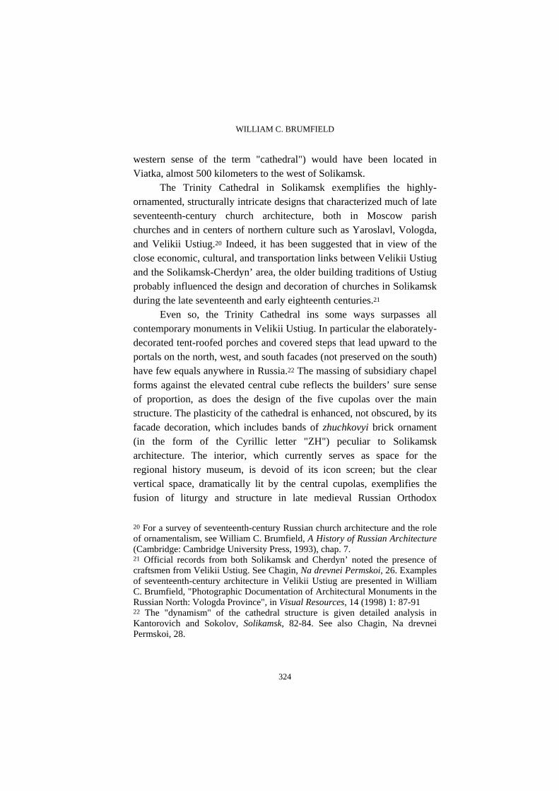
The Trinity Cathedral in Solikamsk exemplifies the highly-ornamented, structurally intricate designs that characterized much of late seventeenth-century church architecture, both in Moscow parish churches and in centers of northern culture such as Yaroslavl, Vologda, and Velikii Ustiug.20 Indeed, it has been suggested that in view of the close economic, cultural, and transportation links between Velikii Ustiug and the Solikamsk-Cherdyn’ area, the older building traditions of Ustiug probably influenced the design and decoration of churches in Solikamsk during the late seventeenth and early eighteenth centuries.21
Even so, the Trinity Cathedral ins some ways surpasses all contemporary monuments in Velikii Ustiug. In particular the elaborately-decorated tent-roofed porches and covered steps that lead upward to the portals on the north, west, and south facades (not preserved on the south) have few equals anywhere in Russia.22 The massing of subsidiary chapel forms against the elevated central cube reflects the builders’ sure sense of proportion, as does the design of the five cupolas over the main structure. The plasticity of the cathedral is enhanced, not obscured, by its facade decoration, which includes bands of zhuchkovyi brick ornament (in the form of the Cyrillic letter "ZH") peculiar to Solikamsk architecture. The interior, which currently serves as space for the regional history museum, is devoid of its icon screen; but the clear vertical space, dramatically lit by the central cupolas, exemplifies the fusion of liturgy and structure in late medieval Russian Orthodox
20 For a survey of seventeenth-century Russian church architecture and the role of ornamentalism, see William C. Brumfield, A History of Russian Architecture (Cambridge: Cambridge University Press, 1993), chap. 7. 21 Official records from both Solikamsk and Cherdyn’ noted the presence of craftsmen from Velikii Ustiug. See Chagin, Na drevnei Permskoi, 26. Examples of seventeenth-century architecture in Velikii Ustiug are presented in William C. Brumfield, "Photographic Documentation of Architectural Monuments in the Russian North: Vologda Province", in Visual Resources, 14 (1998) 1: 87-91 22 The "dynamism" of the cathedral structure is given detailed analysis in Kantorovich and Sokolov, Solikamsk, 82-84. See also Chagin, Na drevnei Permskoi, 28.

THE ARCHITECTURAL HERITAGE OF SOLIKAMSK AND THE NORTHERN DISTRICTS OF PERM PROVINCE
325
architecture. In 1687, soon after the beginning of the Trinity Cathedral, work
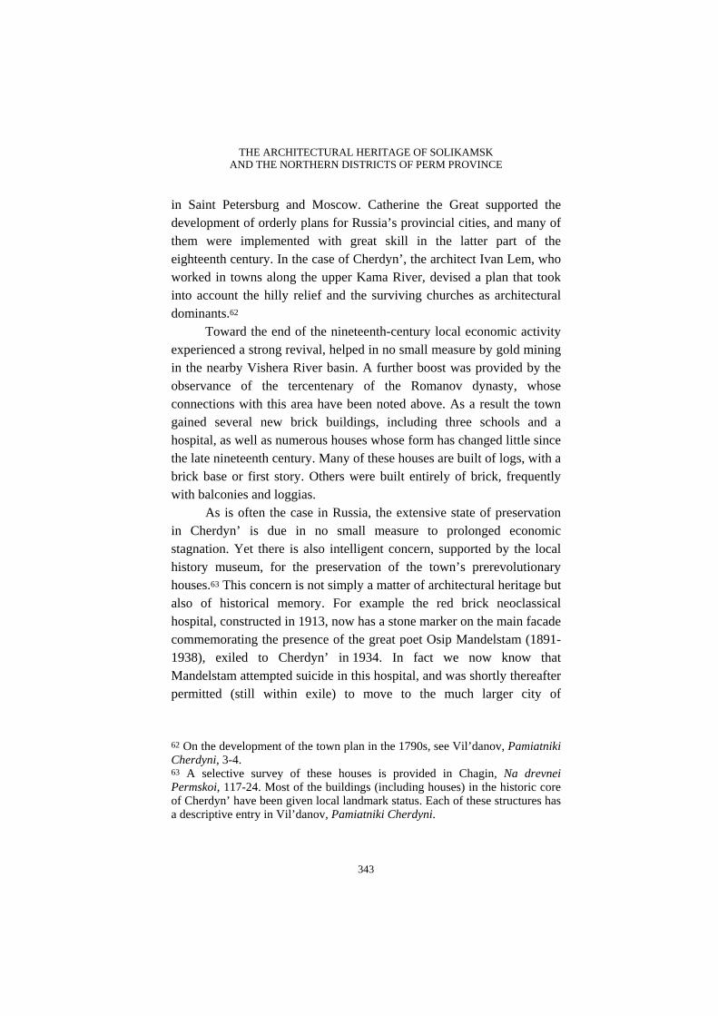
began on the second large masonry structure in Solikamsk, the Church of the Epiphany, completed in 1695 (figure 2). Located on lower ground within fifty meters of the Trinity Cathedral, the Epiphany Church lacks the former’s festive array of secondary structures and does not compete with it in height. Nonetheless, it is one of the most curious examples of church architecture in the western Urals. The two-storied cuboid space of the main sanctuary is buttressed by an interior east wall that conceals the altar and also supports a superb iconostasis, dating from the early nineteenth century and containing seventy-five Stroganov School icons from the seventeenth to the early nineteenth centuries.23 Otherwise, this part of the church is without piers, as was typical of Muscovite parish architecture of the late seventeenth century.
To the west of this core space, the builders created a large one-storied vestibule with an attached chapel on the south (dedicated to the Icon of the Vladimir Mother of God) that increases the width of the church by half. The church culminates at the west end with a three-tiered bell tower rising from a cube to an octagon to a "tent"-covered bell gallery.24 All of the facades of this complex, asymmetrical structure are decorated with the an exuberant array of decorative elements, from the lace-like window surrounds and portals to the corner pilasters, from the richly ornamental ceramic tile strip beneath the cornice to the fanciful
23 A detailed description of the Epiphany Church main iconostasis is provided in Kantorovich and Sokolov, Solikamsk, 90-94. See also Chagin, Na drevnei Permskoi, 35. On Stroganov icons in the Perm area, see O.M. Vlasova, "Stroganovskie Ikony v sobranii Permskoi gosudarstvennoi khudozhestvennoi galerei", in Logvinov, Iskusstvo stroganovskikh masterov, p. 85-114. 24 Soon after construction of the original bell tower, Maksim Surovtsev, a wealthy salt merchant and donor to the church, tripled the height of the tower with three additional tiers in order to accommodate a chiming clock. The additional weight caused the tower to sink almost half a meter. The tower addition was removed during the Soviet era, and a makeshift "tent" roof was reconstructed on the basis of documentary references. See Kantorovich and Sokolov, Solikamsk, 89. For an archival photograph of the church’s extended bell tower at the turn of the twentieth century, see Tushnolobov, Sol’ zemli Kamskoi, 20.
WILLIAM C. BRUMFIELD
326
drums supporting the cupolas. The next major element of the central ensemble in Solikamsk was
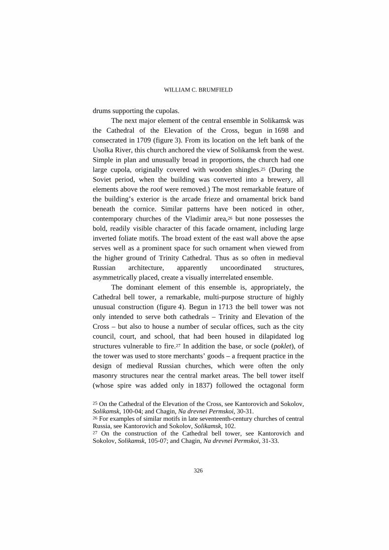
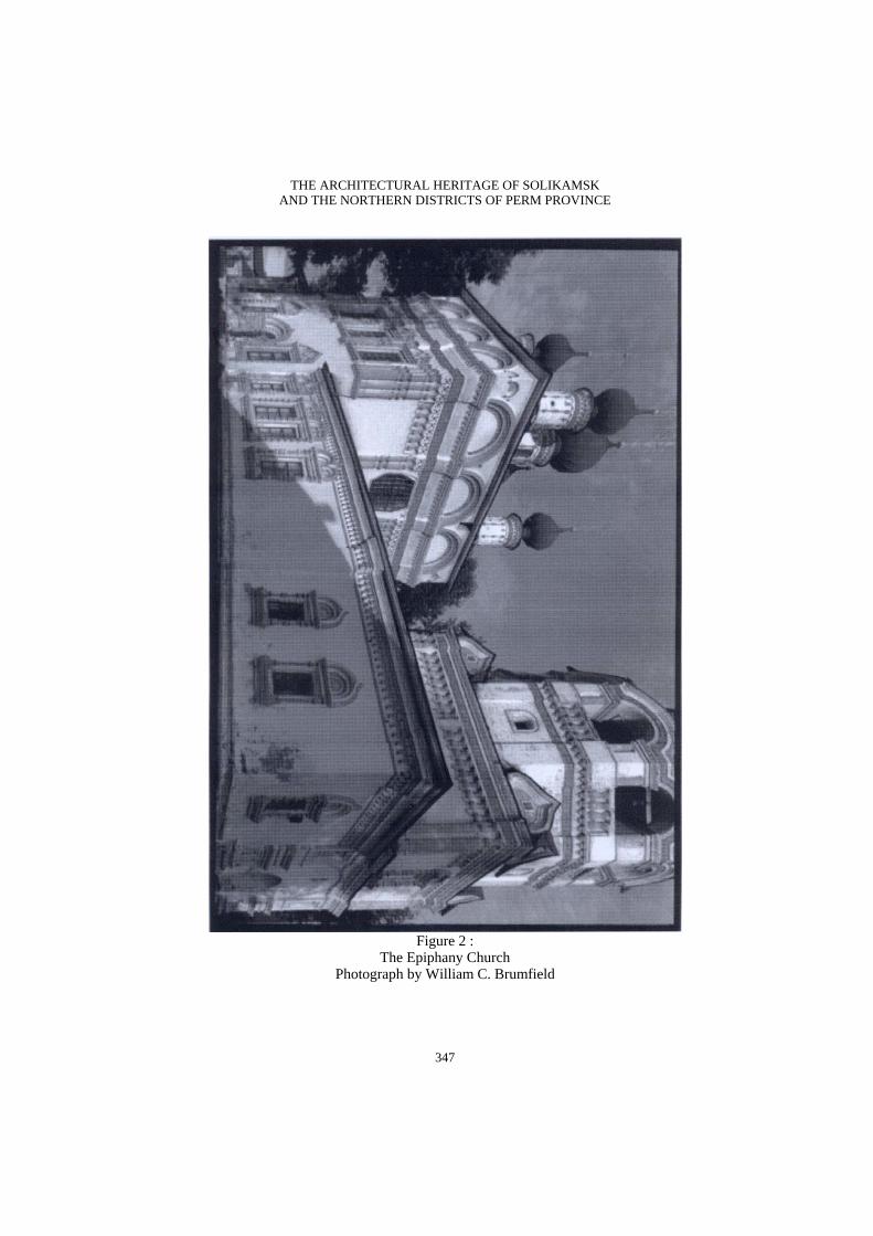
the Cathedral of the Elevation of the Cross, begun in 1698 and consecrated in 1709 (figure 3). From its location on the left bank of the Usolka River, this church anchored the view of Solikamsk from the west. Simple in plan and unusually broad in proportions, the church had one large cupola, originally covered with wooden shingles.25 (During the Soviet period, when the building was converted into a brewery, all elements above the roof were removed.) The most remarkable feature of the building’s exterior is the arcade frieze and ornamental brick band beneath the cornice. Similar patterns have been noticed in other, contemporary churches of the Vladimir area,26 but none possesses the bold, readily visible character of this facade ornament, including large inverted foliate motifs. The broad extent of the east wall above the apse serves well as a prominent space for such ornament when viewed from the higher ground of Trinity Cathedral. Thus as so often in medieval Russian architecture, apparently uncoordinated structures, asymmetrically placed, create a visually interrelated ensemble.
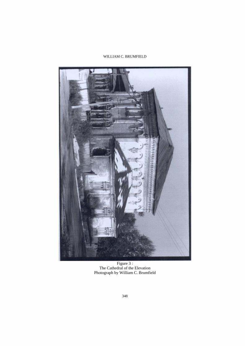
The dominant element of this ensemble is, appropriately, the Cathedral bell tower, a remarkable, multi-purpose structure of highly unusual construction (figure 4). Begun in 1713 the bell tower was not only intended to serve both cathedrals – Trinity and Elevation of the Cross – but also to house a number of secular offices, such as the city council, court, and school, that had been housed in dilapidated log structures vulnerable to fire.27 In addition the base, or socle (poklet), of the tower was used to store merchants’ goods – a frequent practice in the design of medieval Russian churches, which were often the only masonry structures near the central market areas. The bell tower itself (whose spire was added only in 1837) followed the octagonal form
25 On the Cathedral of the Elevation of the Cross, see Kantorovich and Sokolov, Solikamsk, 100-04; and Chagin, Na drevnei Permskoi, 30-31. 26 For examples of similar motifs in late seventeenth-century churches of central Russia, see Kantorovich and Sokolov, Solikamsk, 102. 27 On the construction of the Cathedral bell tower, see Kantorovich and Sokolov, Solikamsk, 105-07; and Chagin, Na drevnei Permskoi, 31-33.

THE ARCHITECTURAL HERITAGE OF SOLIKAMSK AND THE NORTHERN DISTRICTS OF PERM PROVINCE
327
typical of bell towers in Russia, where they generally rose from a compact cuboid structure.
The special challenge in designing the Solikamsk tower arose from the need to accommodate so many other, civil institutions, thus increasing the space required for the lower cuboid structure far beyond the dimensions of the tower octagon. In order to support the immensely heavy tower (which with spire reached a height of sixty meters), the builders erected four interior walls, three meters thick, that converged at the center of the cube. In this solution, unique among medieval Russian monuments, the interior walls supported vaults from which the octagonal tower rose.
The usual relation between the base and the bell tower was further emphasized by the contrast between the simple, undecorated white walls of the lower cube and the bold – indeed, garish – colors that originally defined the elaborate brick patterns of the tower. These included dark-red, green, and yellow for the decorative gables above the bell gallery, green for the rays beneath the checkered brick pattern (also painted), and a mixture of colors for the attached columns that delineated the octagon.28 Despite an attempt to restore the colors in 1976, they are now much faded.
The final component of the central Solikamsk ensemble is composed of two churches under one roof: the Resurrection Church, founded in 1714 but not completed until 1752; and the smaller chapel of the Nativity of Christ, completed in 1721 and located along what would become the north wall of the Resurrection Church.29 These structures were much altered during the communist campaign against the church: their baroque cupolas (five above the Resurrection Church) were removed, and the tall, multi-tiered bell tower above the west entrance to the Resurrection Church was demolished. The remains of the surviving
28 The original polychrome decoration of the bell tower is described in Kantorovich and Sokolov, Solikamsk, 107. 29 On the Church of the Resurrection, with a reconstruction of its original appearance, see Kantorovich and Sokolov, Solikamsk, 107-09. See also Chagin, Na drevnei Permskoi, 33-34.
WILLIAM C. BRUMFIELD
328
large brick structure are nondescript in comparison with the exuberant exterior decoration of the two cathedrals and the Epiphany Church. Their interiors, also now despoiled, originally contained remarkably expressive sculpted figures for the iconostasis, despite the fact that Russian Orthodoxy generally frowned upon three-dimensional representations in church art. In particular the figures of Christ Seated and Mary Mother of God, now both in the Perm Art Museum, are considered among the best examples of wooden statuary created in the Russian provinces during the eighteenth century. As with the other churches grouped around the central Solikamsk market, the base floor of the Resurrection Church was used for storage of merchants’ goods.
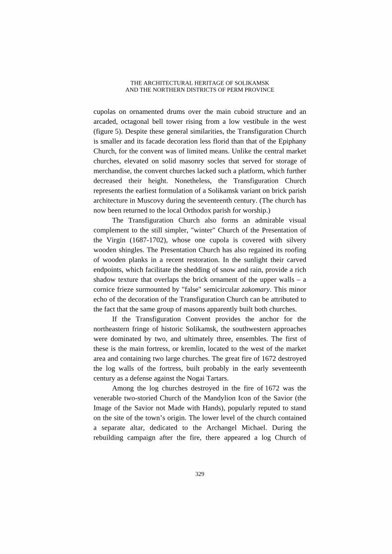
The extraordinary architectural ensemble at the center of Solikamsk forms only one part of a series of monuments created during the prolific era of church construction at the end of the seventeenth century and the beginning of the eighteenth. Some 200 meters to the east of the central ensemble stands the Transfiguration Convent, endowed in 1683 by Evdokiia Shchepotkina, the widow of a Moscow merchant who had enriched himself through trade with Solikamsk.30 Despite its endowment, the convent was poor, and contemporary accounts note that it had no fields of its own or fishing rights.31 Its firewood was typically donated by the men’s Ascension Monastery (see below), and for daily support the convent depended on the alms gathered by the nuns, who lived in modest log dwellings typical of the central area of Solikamsk. Nonetheless, from its inception the convent was endowed with a pair of brick churches, one for use in winter and the other a "summer" church. In contrast to the usual lack of documentation, we actually know the name of the builder, Loginko Korsakov, from contemporary documents.32
The main convent structure, the Church of the Transfiguration (1683-92), resembles the slightly later Epiphany Church, with five
30 On the development of the Transfiguration Convent, see Kantorovich and Sokolov, Solikamsk, 111-16; and Chagin, Na drevnei Permskoi, 39-42. 31 Kantorovich and Sokolov, Solikamsk, 110. 32 TsGADA, fond 137, opis’ 1, delo 14, list 3.
THE ARCHITECTURAL HERITAGE OF SOLIKAMSK AND THE NORTHERN DISTRICTS OF PERM PROVINCE
329
cupolas on ornamented drums over the main cuboid structure and an arcaded, octagonal bell tower rising from a low vestibule in the west (figure 5). Despite these general similarities, the Transfiguration Church is smaller and its facade decoration less florid than that of the Epiphany Church, for the convent was of limited means. Unlike the central market churches, elevated on solid masonry socles that served for storage of merchandise, the convent churches lacked such a platform, which further decreased their height. Nonetheless, the Transfiguration Church represents the earliest formulation of a Solikamsk variant on brick parish architecture in Muscovy during the seventeenth century. (The church has now been returned to the local Orthodox parish for worship.)
The Transfiguration Church also forms an admirable visual complement to the still simpler, "winter" Church of the Presentation of the Virgin (1687-1702), whose one cupola is covered with silvery wooden shingles. The Presentation Church has also regained its roofing of wooden planks in a recent restoration. In the sunlight their carved endpoints, which facilitate the shedding of snow and rain, provide a rich shadow texture that overlaps the brick ornament of the upper walls – a cornice frieze surmounted by "false" semicircular zakomary. This minor echo of the decoration of the Transfiguration Church can be attributed to the fact that the same group of masons apparently built both churches.
If the Transfiguration Convent provides the anchor for the northeastern fringe of historic Solikamsk, the southwestern approaches were dominated by two, and ultimately three, ensembles. The first of these is the main fortress, or kremlin, located to the west of the market area and containing two large churches. The great fire of 1672 destroyed the log walls of the fortress, built probably in the early seventeenth century as a defense against the Nogai Tartars.
Among the log churches destroyed in the fire of 1672 was the venerable two-storied Church of the Mandylion Icon of the Savior (the Image of the Savior not Made with Hands), popularly reputed to stand on the site of the town’s origin. The lower level of the church contained a separate altar, dedicated to the Archangel Michael. During the rebuilding campaign after the fire, there appeared a log Church of
WILLIAM C. BRUMFIELD
330
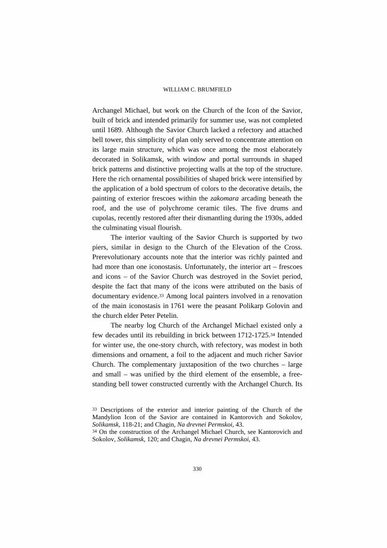
Archangel Michael, but work on the Church of the Icon of the Savior, built of brick and intended primarily for summer use, was not completed until 1689. Although the Savior Church lacked a refectory and attached bell tower, this simplicity of plan only served to concentrate attention on its large main structure, which was once among the most elaborately decorated in Solikamsk, with window and portal surrounds in shaped brick patterns and distinctive projecting walls at the top of the structure. Here the rich ornamental possibilities of shaped brick were intensified by the application of a bold spectrum of colors to the decorative details, the painting of exterior frescoes within the zakomara arcading beneath the roof, and the use of polychrome ceramic tiles. The five drums and cupolas, recently restored after their dismantling during the 1930s, added the culminating visual flourish.
The interior vaulting of the Savior Church is supported by two piers, similar in design to the Church of the Elevation of the Cross. Prerevolutionary accounts note that the interior was richly painted and had more than one iconostasis. Unfortunately, the interior art – frescoes and icons – of the Savior Church was destroyed in the Soviet period, despite the fact that many of the icons were attributed on the basis of documentary evidence.33 Among local painters involved in a renovation of the main iconostasis in 1761 were the peasant Polikarp Golovin and the church elder Peter Petelin.
The nearby log Church of the Archangel Michael existed only a few decades until its rebuilding in brick between 1712-1725.34 Intended for winter use, the one-story church, with refectory, was modest in both dimensions and ornament, a foil to the adjacent and much richer Savior Church. The complementary juxtaposition of the two churches – large and small – was unified by the third element of the ensemble, a free-standing bell tower constructed currently with the Archangel Church. Its
33 Descriptions of the exterior and interior painting of the Church of the Mandylion Icon of the Savior are contained in Kantorovich and Sokolov, Solikamsk, 118-21; and Chagin, Na drevnei Permskoi, 43. 34 On the construction of the Archangel Michael Church, see Kantorovich and Sokolov, Solikamsk, 120; and Chagin, Na drevnei Permskoi, 43.

THE ARCHITECTURAL HERITAGE OF SOLIKAMSK AND THE NORTHERN DISTRICTS OF PERM PROVINCE
331
tall octagonal form, rising above a low rectangular base situated near the bank of the Usolka River, created an important vertical dominant in the western part of Solikamsk. Typically, this visible symbol of an earlier era was demolished in the 1930s, when the cupolas were also removed from the adjacent churches.
The next step toward the western end of Solikamsk is marked by the Monastery of the Ascension, which existed as early as the second half of the sixteenth century.35 Rebuilt in 1608, the monastery consisted of wooden buildings until the end of the seventeenth century, when work began on the Church of the Ascension (1698-1704), another peculiar masterpiece in the Solikamsk repertoire. Although the interior contained only one story, the main part of the church was elevated on a socle and had two levels of windows, thus creating a strong vertical center within the monastery compound (figure 6). Its one cupola and simple roof surmount a white-walled structure that is among the most richly decorated in Solikamsk. The window surrounds, for example, are comparable to those of the Church of the Elevation of the Cross. The most expressive components are the projecting frieze and decorative arches (zakomary) below the roof line. It has been suggested that these elements influenced the design of contemporaneous buildings such as the Church of St. Nicholas in Nyrob (see figure 9), begun just after the completion of the Ascension Church.36 The other components of the church, including a low refectory in the west and the Chapel of the Annunciation attached to the south facade, create a picturesque agglomeration dominated by the main structure.
Now that the Ascension Church has been partially repaired and returned to active use, it is difficult to imagine that such a festive structure housed punishment cells, when the monastery was used as a prison during the Soviet era. Perhaps that elusive quality of historical
35 A summary of the institutional history of the Solikamsk Ascension-Trinity Monastery is contained in Leonid I. Denisov, Pravoslavnye monastyri Rossiiskoi imperii (Moscow: A.D. Stupin, 1908), 656-657. 36 On the form of the Ascension Church, Kantorovich and Sokolov, Solikamsk, 120, 122-23; and Chagin, Na drevnei Permskoi, 44-45.
WILLIAM C. BRUMFIELD
332
memory explains why the church has decided – at least for the foreseeable future – to leave a few of the cell doors intact along the eastern part of the interior. Even today, their presence effects a grim evocation of the repression of the stalinist era in its iron specificity.
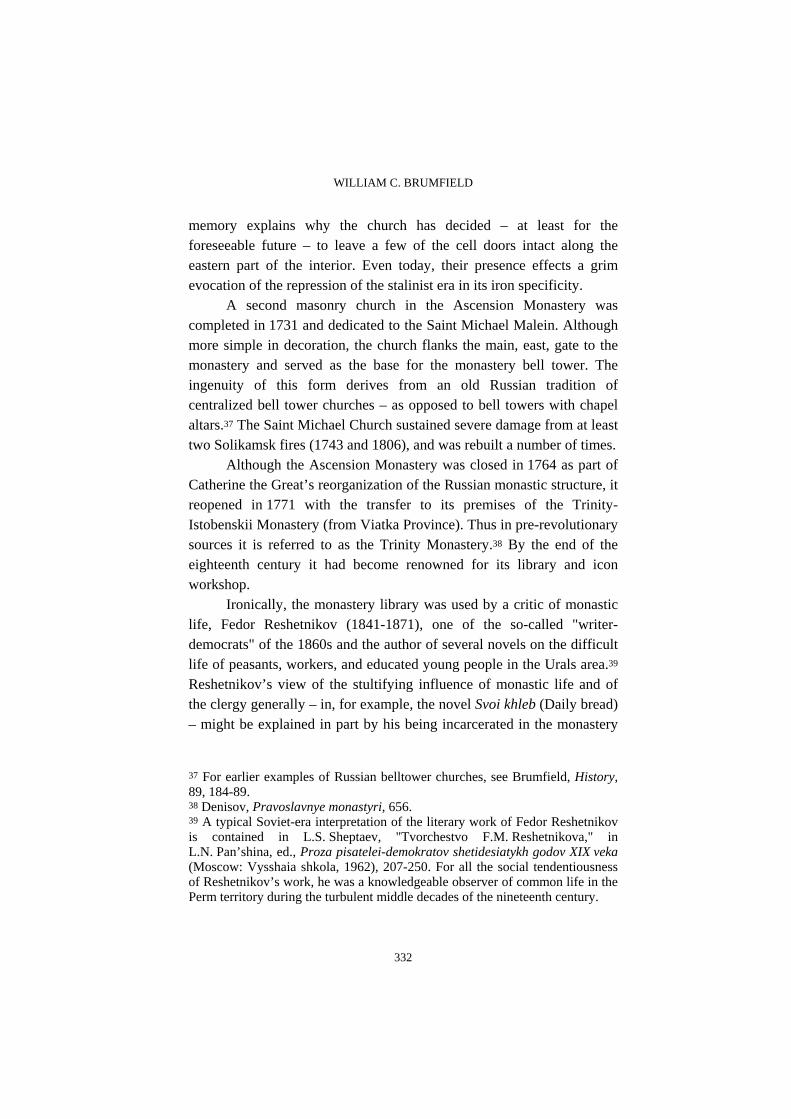
A second masonry church in the Ascension Monastery was completed in 1731 and dedicated to the Saint Michael Malein. Although more simple in decoration, the church flanks the main, east, gate to the monastery and served as the base for the monastery bell tower. The ingenuity of this form derives from an old Russian tradition of centralized bell tower churches – as opposed to bell towers with chapel altars.37 The Saint Michael Church sustained severe damage from at least two Solikamsk fires (1743 and 1806), and was rebuilt a number of times.
Although the Ascension Monastery was closed in 1764 as part of Catherine the Great’s reorganization of the Russian monastic structure, it reopened in 1771 with the transfer to its premises of the Trinity-Istobenskii Monastery (from Viatka Province). Thus in pre-revolutionary sources it is referred to as the Trinity Monastery.38 By the end of the eighteenth century it had become renowned for its library and icon workshop.
Ironically, the monastery library was used by a critic of monastic life, Fedor Reshetnikov (1841-1871), one of the so-called "writer-democrats" of the 1860s and the author of several novels on the difficult life of peasants, workers, and educated young people in the Urals area.39 Reshetnikov’s view of the stultifying influence of monastic life and of the clergy generally – in, for example, the novel Svoi khleb (Daily bread) – might be explained in part by his being incarcerated in the monastery
37 For earlier examples of Russian belltower churches, see Brumfield, History, 89, 184-89. 38 Denisov, Pravoslavnye monastyri, 656. 39 A typical Soviet-era interpretation of the literary work of Fedor Reshetnikov is contained in L.S. Sheptaev, "Tvorchestvo F.M. Reshetnikova," in L.N. Pan’shina, ed., Proza pisatelei-demokratov shetidesiatykh godov XIX veka (Moscow: Vysshaia shkola, 1962), 207-250. For all the social tendentiousness of Reshetnikov’s work, he was a knowledgeable observer of common life in the Perm territory during the turbulent middle decades of the nineteenth century.

THE ARCHITECTURAL HERITAGE OF SOLIKAMSK AND THE NORTHERN DISTRICTS OF PERM PROVINCE
333
in 1857 for having lost or (allegedly) misplaced state documents entrusted to his guardian uncle, an employee of the postal service. This episode also illustrates that Russian monasteries had a long tradition of use as places of incarceration, even before their expropriation and conversion to prisons by the Soviets.
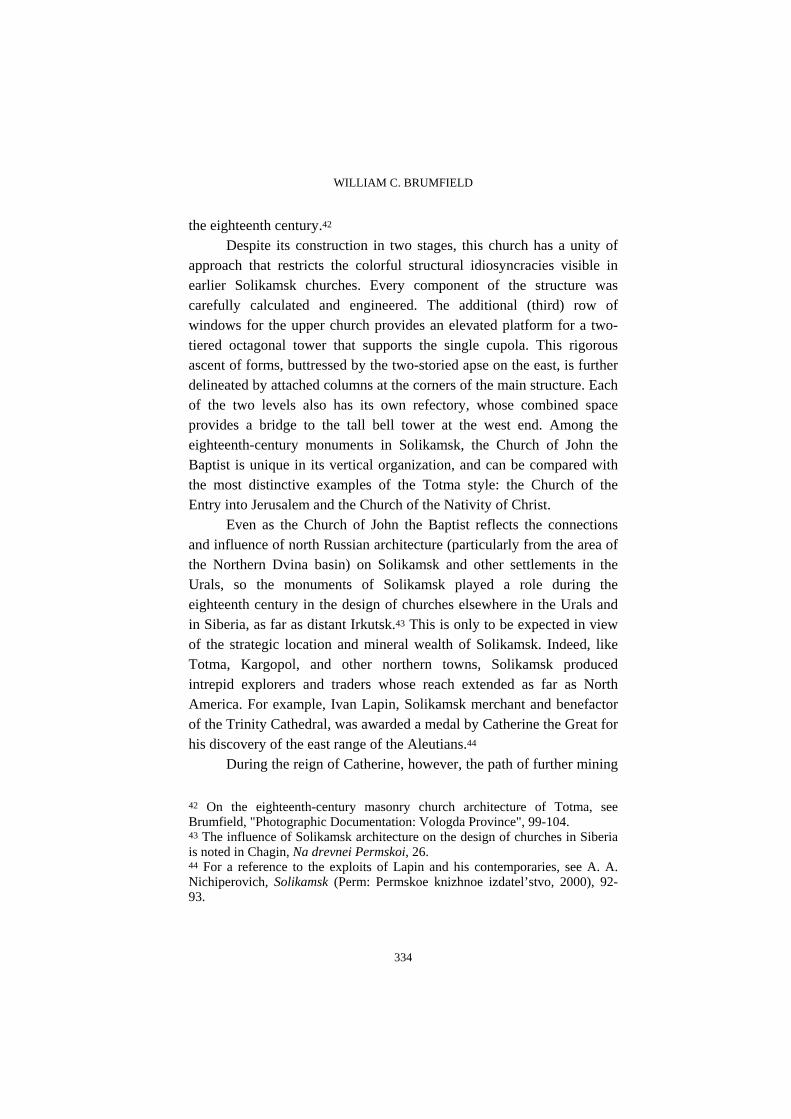
The farthest architectural dominant on the western fringes of Solikamsk is the Church of John the Baptist, situated in what was formerly known as the village of Krasnoe. Located near the banks of the Usolka, the soaring forms of the church and its six-tiered bell tower could be seen from the Kama River, and thus served as a beacon for boats headed toward Solikamsk via the Usolka.40 As was the case in the town of Totma, an important northern Russian center of commerce and church construction in the eighteenth century, the tall forms of the Church of John the Baptist arose in two stages (figure 7). The first stage, the "lower temple" dedicated to John the Baptist, was begun in 1715 and completed in 1721 with the support of a donation by the salt merchant Ivan Surovtsev. The upper church, dedicated to Saint John the Warrior, was completed in 1772 with a donation by Count Aleksei Turchaninov, who owned the village of Krasnoe as well as a large copper smelting factory.41
The facades of the Church of John the Baptist display the decorative flourishes typical of the Solikamsk style: the zhuchok ornamental bands, the baroque-inspired window surrounds similar to those of the Church of the Elevation of the Cross. Yet the design of the structure and its overall proportions show a more rigorous definition of form that not only reminds, again, of eighteenth-century architecture in northern towns such as Totma, but also suggests the spread of professional design standards into the provinces during the latter half of
40 On the Church of John the Baptist and its use as a river beacon, see Kantorovich and Sokolov, Solikamsk, 149. 41 A brief construction history of the Church of John the Baptist is presented in Chagin, Na drevnei Permskoi, 45-46. A descendent of Solikamsk merchants, Turchaninov was ennobled by Catherine the Great for his role in the suppression of the Pugachev Rebellion (1774). See Kantorovich and Sokolov, Solikamsk, 18-19.
WILLIAM C. BRUMFIELD
334
the eighteenth century.42 Despite its construction in two stages, this church has a unity of
approach that restricts the colorful structural idiosyncracies visible in earlier Solikamsk churches. Every component of the structure was carefully calculated and engineered. The additional (third) row of windows for the upper church provides an elevated platform for a two-tiered octagonal tower that supports the single cupola. This rigorous ascent of forms, buttressed by the two-storied apse on the east, is further delineated by attached columns at the corners of the main structure. Each of the two levels also has its own refectory, whose combined space provides a bridge to the tall bell tower at the west end. Among the eighteenth-century monuments in Solikamsk, the Church of John the Baptist is unique in its vertical organization, and can be compared with the most distinctive examples of the Totma style: the Church of the Entry into Jerusalem and the Church of the Nativity of Christ.
Even as the Church of John the Baptist reflects the connections and influence of north Russian architecture (particularly from the area of the Northern Dvina basin) on Solikamsk and other settlements in the Urals, so the monuments of Solikamsk played a role during the eighteenth century in the design of churches elsewhere in the Urals and in Siberia, as far as distant Irkutsk.43 This is only to be expected in view of the strategic location and mineral wealth of Solikamsk. Indeed, like Totma, Kargopol, and other northern towns, Solikamsk produced intrepid explorers and traders whose reach extended as far as North America. For example, Ivan Lapin, Solikamsk merchant and benefactor of the Trinity Cathedral, was awarded a medal by Catherine the Great for his discovery of the east range of the Aleutians.44
During the reign of Catherine, however, the path of further mining
42 On the eighteenth-century masonry church architecture of Totma, see Brumfield, "Photographic Documentation: Vologda Province", 99-104. 43 The influence of Solikamsk architecture on the design of churches in Siberia is noted in Chagin, Na drevnei Permskoi, 26. 44 For a reference to the exploits of Lapin and his contemporaries, see A. A. Nichiperovich, Solikamsk (Perm: Permskoe knizhnoe izdatel’stvo, 2000), 92-93.

THE ARCHITECTURAL HERITAGE OF SOLIKAMSK AND THE NORTHERN DISTRICTS OF PERM PROVINCE
335
and industrial development in the Urals shifted to the south, to the newer settlements of Perm and Ekaterinburg, which were served not by the Babinov Road, but by the newly opened Siberian Route (Sibirskii trakt). Although he continued to live in Solikamsk, Count Turchaninov closed his copper factory in the 1770s, and the Solikamsk salt works lost their dominant position to more efficient works elsewhere, such as those owned by the Stroganovs at Usolye, down the Kama River on the opposite bank.45 The extent of the town’s decline was observed in the 1840s by the writer Pavel Melnikov-Pecherskii (1819-83), who in his Dorozhnye zapiski (Notes from the Road), remarked the depressing appearance of "ruined magnificence," of empty, overgrown streets and desolation.46
Nonetheless, Solikamsk experienced modest growth in the latter part of the nineteenth century, a revival evident from a number of brick buildings whose design is typical of Russian provincial towns, from the western areas of the empire to distant Siberia. The major reason for this positive turn was the renovation in the 1870s of local salt works under the ownership of the Riazantsev family at the nearby settlement of Ust-Borovoe. Although working conditions in the Riazantsev refineries were harsh, it is beyond doubt that the Riazantsev technical and entrepreneurial abilities had a leavening effect on the local economy. Indeed, salt continued to be produced at the former Riazantsev works (under Soviet ownership) until 1972.47
Although they have only recently been granted landmark status, most of the nineteenth-century log buildings connected with salt refining in Solikamsk have been preserved as a distinctive example of local
45 The decline of Solikamsk in the nineteenth century is discussed in Kantorovich and Sokolov, Solikamsk, 19-21. 46 See P.I. Melnikov, Sobranie sochinenii v 6 tomakh, vol. 6 (Moscow: Pravda, 1963). 47 For a detailed survey, in Russian and English, of the development of the Ust-Borovskoi salt works, see Evgenii Logunov, Lidiia Perminova, and Vladimir Shkerin, Ust’-Borovskoi solevarennyi zavod: Vchera, segodnia, zavtra (Ekaterinburg: Bank kul’turnoi informatsii, 1995). See also Kantorovich and Sokolov, Solikamsk, 129-31.
WILLIAM C. BRUMFIELD
336
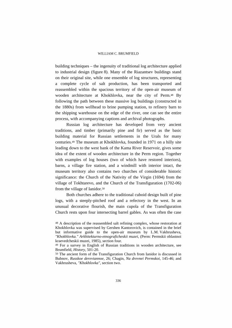
building techniques – the ingenuity of traditional log architecture applied to industrial design (figure 8). Many of the Riazantsev buildings stand on their original site, while one ensemble of log structures, representing a complete cycle of salt production, has been transported and reassembled within the spacious territory of the open-air museum of wooden architecture at Khokhlovka, near the city of Perm.48 By following the path between these massive log buildings (constructed in the 1880s) from wellhead to brine pumping station, to refinery barn to the shipping warehouse on the edge of the river, one can see the entire process, with accompanying captions and archival photographs.
Russian log architecture has developed from very ancient traditions, and timber (primarily pine and fir) served as the basic building material for Russian settlements in the Urals for many centuries.49 The museum at Khokhlovka, founded in 1971 on a hilly site leading down to the west bank of the Kama River Reservoir, gives some idea of the extent of wooden architecture in the Perm region. Together with examples of log houses (two of which have restored interiors), barns, a village fire station, and a windmill with interior intact, the museum territory also contains two churches of considerable historic significance: the Church of the Nativity of the Virgin (1694) from the village of Tokhtarevo, and the Church of the Transfiguration (1702-06) from the village of Ianidor.50
Both churches adhere to the traditional cuboid design built of pine logs, with a steeply-pitched roof and a refectory in the west. In an unusual decorative flourish, the main cupola of the Transfiguration Church rests upon four intersecting barrel gables. As was often the case
48 A description of the reassembled salt refining complex, whose restoration at Khokhlovka was supervised by Gershen Kantorovich, is contained in the brief but informative guide to the open-air museum by L.M. Vakhrusheva, "Khokhlovka." Arkhitekturno-etnograficheskii muzei, (Perm: Permskii oblastnoi kraevedcheskii muzei, 1985), section four. 49 For a survey in English of Russian traditions in wooden architecture, see Brumfield, History, 501-20. 50 The ancient form of the Transfiguration Church from Ianidor is discussed in Bubnov, Russkoe dereviannoe, 26; Chagin, Na drevnei Permskoi, 145-46; and Vakhrusheva, "Khokhlovka", section two.

THE ARCHITECTURAL HERITAGE OF SOLIKAMSK AND THE NORTHERN DISTRICTS OF PERM PROVINCE
337
in severe northern climates, the Church of the Transfiguration was raised on a two-meter base (podklet) to place it well above snow level. During a restoration undertaken in 1984-85 by Boris Gnedovskii and Gershen Kantorovich, an elevated porch and gallery were reconstructed on the west and north facades. Despite the care with which this monument has been reassembled, it is unfortunate that the Church of the Transfiguration no longer exists within its original village setting.
There is, however, at least one wooden church in the Perm territory that still stands on its original site: the Church of the Icon of the Smolensk Mother of God (also known as the Epiphany Church) at Pianteg. Situated on the steep left bank of the Kama River some forty kilometers southwest of Cherdyn’, the church at Pianteg is the oldest surviving log structure in the western Urals, with dates for its construction ranging from the end of the sixteenth century to no later than 1617.51 Among the various riddles posed by this archaic structure is the question of its original form. Its unusual hexagonal plan (the only known surviving example; most polygonal Russian wooden churches are eight-sided) suggests a possible derivation from log hexagonal fortress towers. Studies of the interior and upper log construction strongly suggest that in place of the current low-pitched roof, the original design culminated in a high "tent" roof similar to those above other polygonal log churches from the sixteenth through the eighteenth centuries. Despite the monument’s present diminished state, its stout log walls suggest the
51 The Pianteg church has been the subject of much scholarly interest, although many questions remain about its date of construction and original form. See G.A. Volegov, "Kratkoe opisanie sela Piantezhskogo", in Materialy po izucheniiu Permskogo kraia, 5(1915); I.V. Makovetskii, Pamiatniki narodnogo zodchestva russkogo Severa (Moscow, 1955); "Pianteg: Bogoiavlenskaia Tserkov’," in Gershen Kantorovich, Pamiatniki arkhitektury Permskoi oblasti (Perm: Permskoe knizhnoe izdatel’stvo, 1971); Bubnov, Russkoe dereviannoe, 26; and Chagin, Na drevnei Permskoi, 127-30. Chagin refers to the monument simply as Church of the Mother of God (Bogoroditskaia). Bubnov places the date of construction "on the boundary between the fifteenth and sixteenth centuries" (p. 26), but that is apparently an oversight. Every other source places the construction at the end of the sixteenth or beginning of the seventeenth century.
WILLIAM C. BRUMFIELD
338
soaring vertical forms that represent the inspired vision of medieval Russian craftsmen.
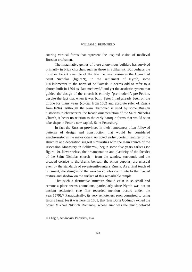
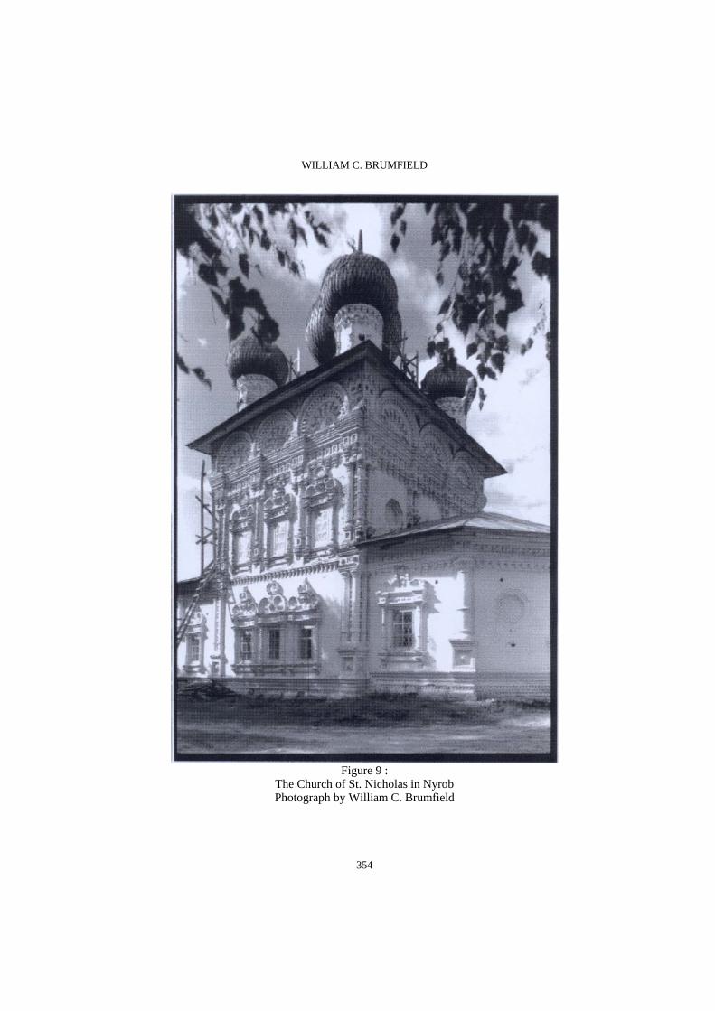
The imaginative genius of these anonymous builders has survived primarily in brick churches, such as those in Solikamsk. But perhaps the most exuberant example of the late medieval vision is the Church of Saint Nicholas (figure 9), in the settlement of Nyrob, some 160 kilometers to the north of Solikamsk. It seems odd to refer to a church built in 1704 as "late medieval," and yet the aesthetic system that guided the design of the church is entirely "pre-modern", pre-Petrine, despite the fact that when it was built, Peter I had already been on the throne for many years (co-tsar from 1682 and absolute ruler of Russia from 1694). Although the term "baroque" is used by some Russian historians to characterize the facade ornamentation of the Saint Nicholas Church, it bears no relation to the early baroque forms that would soon take shape in Peter’s new capital, Saint Petersburg.
In fact the Russian provinces in their remoteness often followed patterns of design and construction that would be considered anachronistic in the major cities. As noted earlier, certain features of the structure and decoration suggest similarities with the main church of the Ascension Monastery in Solikamsk, begun some five years earlier (see figure 10). Nevertheless, the ornamentation and plasticity of the facades of the Saint Nicholas church – from the window surrounds and the arcaded cornice to the drums beneath the onion cupolas, are unusual even by the standards of seventeenth-century Russia. As a final touch of ornament, the shingles of the wooden cupolas contribute to the play of texture and shadow on the surface of this remarkable temple.
That such a distinctive structure should exist in so small and remote a place seems anomalous, particularly since Nyrob was not an ancient settlement (the first recorded mention occurs under the year 1579).52 Paradoxically, its very remoteness soon conspired to bring lasting fame, for it was here, in 1601, that Tsar Boris Godunov exiled the boyar Mikhail Nikitich Romanov, whose aunt was the much beloved
52 Chagin, Na drevnei Permskoi, 154.

THE ARCHITECTURAL HERITAGE OF SOLIKAMSK AND THE NORTHERN DISTRICTS OF PERM PROVINCE
339
first wife of Ivan the Terrible, Anastasia. The ambitious Godunov had reasons for concern about his own unsteady claims on the Muscovite throne after the end of the Riurikovich dynasty in 1598, and in order to eliminate potential rivals, he subjected Mikhail Nikitich to harsh treatment in Nyrob. Kept in fetters and thrown into a deep pit, Mikhail died the following year.
However, Godunov’s own days were numbered, and after his death in 1605, Russia was plunged into a devastating dynastic crisis known as the "Time of Troubles".53 Although its consequences lingered for decades, that crisis formally ended in 1613 with the accession to the throne of Mikhail Fedorovich Romanov, nephew of Mikhail Nikitich and son of Fedor Nikitich Romanov, who led the Russian Orthodox Church as Metropolitan, and subsequently Patriarch, Filaret. Thus Nyrob had impressive claims as a significant place in the sacralization of the Romanov ascent to dynastic authority. Indeed, the first Church of Saint Nicholas was built of logs near the original burial place of Mikhail Nikitich almost immediately after the establishment of the dynasty in 1613. At the beginning of the following century, the small settlement gained an unusually imposing ensemble of two masonry churches – Saint Nicholas (1704) and the adjacent, more modest winter church of the Epiphany (1736) – as well as a tall octagonal bell tower (destroyed in 1934). The interiors of both churches were soon richly painted, but much of that work has been lost, particularly in the Epiphany Church, which held the original casket of Mikhail Nikitich Romanov.
The route southward from Nyrob follows the Kolva River and
passes through a series of small towns such as Iskor, Kamgort, Vilgort, and Pokcha, each of which had its moments of prosperity in the eighteenth and nineteenth centuries. As noted above, the most important town in this area north of Solikamsk is Cherdyn’, ancient customs post and gateway to Siberia. The town’s sixteenth-century log fortress, or
53 For an excellent concise historical analysis of the Time of Troubles, see Nicholas V. Riasanovsky, A History of Russia (New York: Oxford University Press, 2000), p. 157-74.
WILLIAM C. BRUMFIELD
340
kremlin (the first such example in the Urals), was reconstructed in the seventeenth century and defended the heights on the right bank of the Kolva River. By the turn of the eighteenth century an additional log wall, with six small towers, surrounded the main settlement, whose population in 1678 was calculated at 782 male souls (women and children not counted).54
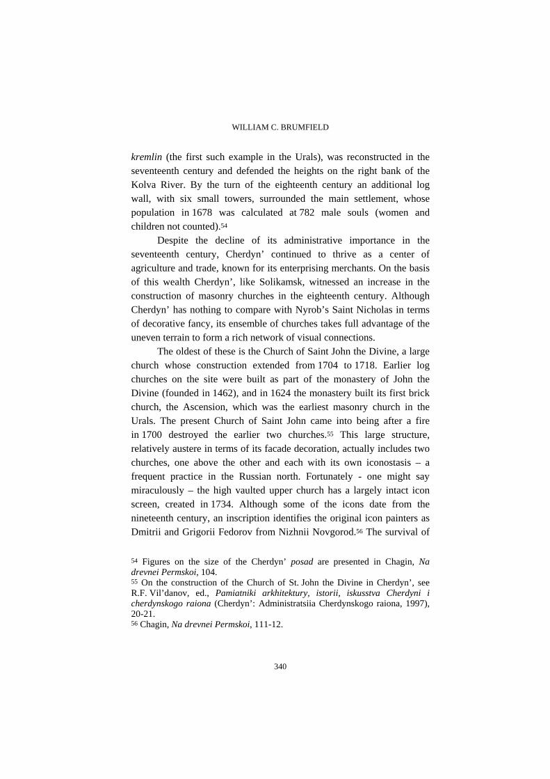
Despite the decline of its administrative importance in the seventeenth century, Cherdyn’ continued to thrive as a center of agriculture and trade, known for its enterprising merchants. On the basis of this wealth Cherdyn’, like Solikamsk, witnessed an increase in the construction of masonry churches in the eighteenth century. Although Cherdyn’ has nothing to compare with Nyrob’s Saint Nicholas in terms of decorative fancy, its ensemble of churches takes full advantage of the uneven terrain to form a rich network of visual connections.
The oldest of these is the Church of Saint John the Divine, a large church whose construction extended from 1704 to 1718. Earlier log churches on the site were built as part of the monastery of John the Divine (founded in 1462), and in 1624 the monastery built its first brick church, the Ascension, which was the earliest masonry church in the Urals. The present Church of Saint John came into being after a fire in 1700 destroyed the earlier two churches.55 This large structure, relatively austere in terms of its facade decoration, actually includes two churches, one above the other and each with its own iconostasis – a frequent practice in the Russian north. Fortunately - one might say miraculously – the high vaulted upper church has a largely intact icon screen, created in 1734. Although some of the icons date from the nineteenth century, an inscription identifies the original icon painters as Dmitrii and Grigorii Fedorov from Nizhnii Novgorod.56 The survival of
54 Figures on the size of the Cherdyn’ posad are presented in Chagin, Na drevnei Permskoi, 104. 55 On the construction of the Church of St. John the Divine in Cherdyn’, see R.F. Vil’danov, ed., Pamiatniki arkhitektury, istorii, iskusstva Cherdyni i cherdynskogo raiona (Cherdyn’: Administratsiia Cherdynskogo raiona, 1997), 20-21. 56 Chagin, Na drevnei Permskoi, 111-12.
THE ARCHITECTURAL HERITAGE OF SOLIKAMSK AND THE NORTHERN DISTRICTS OF PERM PROVINCE
341
the icon screen is particularly appropriate for what is (as of this writing) the only functioning church in Cherdyn’.
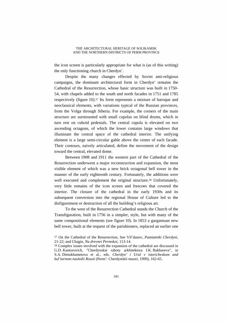
Despite the many changes effected by Soviet anti-religious campaigns, the dominant architectural form in Cherdyn’ remains the Cathedral of the Resurrection, whose basic structure was built in 1750-54, with chapels added to the south and north facades in 1751 and 1785 respectively (figure 10).57 Its form represents a mixture of baroque and neoclassical elements, with variations typical of the Russian provinces, from the Volga through Siberia. For example, the corners of the main structure are surmounted with small cupolas on blind drums, which in turn rest on cuboid pedestals. The central cupola is elevated on two ascending octagons, of which the lower contains large windows that illuminate the central space of the cathedral interior. The unifying element is a large semi-circular gable above the center of each facade. Their contours, naively articulated, define the movement of the design toward the central, elevated dome.
Between 1908 and 1911 the western part of the Cathedral of the Resurrection underwent a major reconstruction and expansion, the most visible element of which was a new brick octagonal bell tower in the manner of the early eighteenth century. Fortunately, the additions were well executed and complement the original structure.58 Unfortunately, very little remains of the icon screen and frescoes that covered the interior. The closure of the cathedral in the early 1930s and its subsequent conversion into the regional House of Culture led to the disfigurement or destruction of all the building’s religious art.
To the west of the Resurrection Cathedral stands the Church of the Transfiguration, built in 1756 in a simpler, style, but with many of the same compositional elements (see figure 10). In 1853 a gargantuan new bell tower, built at the request of the parishioners, replaced an earlier one
57 On the Cathedral of the Resurrection, See Vil’danov, Pamiatniki Cherdyni, 21-22; and Chagin, Na drevnei Permskoi, 113-14. 58 Complex issues involved with the expansion of the cathedral are discussed in G.D. Kantorovich, "Cherdynskie raboty arkhitektora I.K. Bakhareva", in S.A. Dimukhametova et al., eds. Cherdyn’ i Ural v istoricheskom and kul’turnom nasledii Rossii (Perm’: Cherdynskii muzei, 1999), 162-65.
WILLIAM C. BRUMFIELD
342
and became the dominant vertical center of the entire town.59 With the closing of the church in the early 1930s and its conversion into a forestry technical school, the cupolas were removed and the bell tower was gradually dismantled – a process that lasted until the early 1950s.
Farther to the west of the riverbank and between the monastery and cathedral complex was the third of Cherdyn’’s large churches, the Epiphany, completed in 1751. The church and its three altars withstood severe damage from the fire of 1792. At the end of the nineteenth century, its bell tower was rebuilt.60 The bell tower and the cupolas were removed during the Soviet period when the church was converted to a bakery – a function it serves to this day.
The final church of the central ensemble is also the smallest and most refined in its detailing: the Church of the Dormition, completed in 1784. After the closing of the church in 1932, its cupola and bell tower were removed, and it stood empty until its acquisition by the Museum of Local History in the mid-1950s.61 In the autumn of 2000 it reopened as the Museum of Religious Belief. It would appear that Cherdyn’, with a population of just over 6,000, can support only one active church at present, yet the city administration has decided to encourage the religious revival by sponsoring this museum within a former church.
Despite the loss of most of the church bell towers during the Soviet period, the churches of Cherdyn’ still provide visual points of reference for Cherdyn’. The town plan follows the grid pattern created after the great fire of 1792 by the Commission for Masonry Construction
59 The role of this and other now-destroyed bell towers as defining elements in the Cherdyn’ landscape is admirably conveyed in panoramic photograph taken by Sergei Mikhailovich Prokudin-Gorskii in 1909. See William Craft Brumfield, "The Color Photographs of Sergei Mikhailovich Prokudin-Gorskii", in Visual Resources, 6(1990)3:249. The various modifications to the Church of the Transfiguration are described in Vil’danov, Pamiatniki Cherdyni, 22-23; and Chagin, Na drevnei Permskoi, 114. 60 On the Church of the Epiphany, see Vil’danov, Pamiatniki Cherdyni, 36; and Chagin, Na drevnei Permskoi, 114-15. 61 On the Church of the Dormition, see Vil’danov, Pamiatniki Cherdyni, 8-9; and Chagin, Na drevnei Permskoi, 116.
THE ARCHITECTURAL HERITAGE OF SOLIKAMSK AND THE NORTHERN DISTRICTS OF PERM PROVINCE
343
in Saint Petersburg and Moscow. Catherine the Great supported the development of orderly plans for Russia’s provincial cities, and many of them were implemented with great skill in the latter part of the eighteenth century. In the case of Cherdyn’, the architect Ivan Lem, who worked in towns along the upper Kama River, devised a plan that took into account the hilly relief and the surviving churches as architectural dominants.62
Toward the end of the nineteenth-century local economic activity experienced a strong revival, helped in no small measure by gold mining in the nearby Vishera River basin. A further boost was provided by the observance of the tercentenary of the Romanov dynasty, whose connections with this area have been noted above. As a result the town gained several new brick buildings, including three schools and a hospital, as well as numerous houses whose form has changed little since the late nineteenth century. Many of these houses are built of logs, with a brick base or first story. Others were built entirely of brick, frequently with balconies and loggias.
As is often the case in Russia, the extensive state of preservation in Cherdyn’ is due in no small measure to prolonged economic stagnation. Yet there is also intelligent concern, supported by the local history museum, for the preservation of the town’s prerevolutionary houses.63 This concern is not simply a matter of architectural heritage but also of historical memory. For example the red brick neoclassical hospital, constructed in 1913, now has a stone marker on the main facade commemorating the presence of the great poet Osip Mandelstam (1891-1938), exiled to Cherdyn’ in 1934. In fact we now know that Mandelstam attempted suicide in this hospital, and was shortly thereafter permitted (still within exile) to move to the much larger city of
62 On the development of the town plan in the 1790s, see Vil’danov, Pamiatniki Cherdyni, 3-4. 63 A selective survey of these houses is provided in Chagin, Na drevnei Permskoi, 117-24. Most of the buildings (including houses) in the historic core of Cherdyn’ have been given local landmark status. Each of these structures has a descriptive entry in Vil’danov, Pamiatniki Cherdyni.

WILLIAM C. BRUMFIELD
344
Voronezh.64 Mandelstam’s fate was tragic, as was that of so many others in the Soviet Union – and in Cherdyn’ – during the 1930s. But for that the town cannot be blamed.
Other, smaller settlements in the Cherdyn’ area also have their monuments. For example, Pokcha, located five kilometers north of Cherdyn’ and "capital" of the Perm region from 1472 to 1535, has at its center a small but worthy ensemble of buildings, as well as the large Church of the Annunciation, all built of red brick at the turn of the twentieth century and all virtually abandoned. These proud buildings, facing the Kolva River, now convey the impression of a ghost town, although Pokcha is still inhabited.65
Some of these village churches rise like apparitions on the top of a hill, at a bend in the road. The gleaming white Church of the Trinity in Vilgort (between Cherdyn’ and Nyrob) is an example. Its original structure, built in 1779, culminates in a curious cornice frieze of archaic decorative motifs that derive from the Solikamsk area, but also resemble the church ornament of far distant Eniseisk, in central Siberia. This church, with its red brick refectory added in 1902, was converted into the local "House of Culture" (i.e., club and cinema) in the Soviet period, but a segment of its prerevolutionary frescoes have survived.66
The preceding survey has presented the architectural heritage of an area that in centuries past served as one of Russia’s key strategic points in the settlement of the Urals and Siberia. Although power shifted to the south during the eighteenth century, the architectural monuments of settlements in the north of Perm oblast’ remind of an enduring cultural and historical significance. As elsewhere in contemporary
64 For further information on Mandelstam’s exile in Cherdyn’, see Clarence Brown, The Prose of Osip Mandelstam (Princeton: Princeton University Press, 1965), 19. 65 The architectural heritage of Pokcha is described in Chagin, Na drevnei Permskoi, 131-39; and Vil’danov, Pamiatniki Cherdyni, 43-45. 66 On Vilgort, see Chagin, Na drevnei Permskoi, 140-43; and Vil’danov, Pamiatniki Cherdyni, 37-39. Basic information, including administrative ownership, on these and other monuments in the Cherdyn’ region is provided in Iurii V. Ushakov, ed., Pamiatniki istorii i kul’tury Permskoi oblasti, vol. 2: Pamiatniki istorii, arkhitektury i iskusstva (Perm: "Arabesk," 1993).

THE ARCHITECTURAL HERITAGE OF SOLIKAMSK AND THE NORTHERN DISTRICTS OF PERM PROVINCE
345
Russia, fundamental economic and social restructuring has deprived cultural institutions of the means to support many essential restoration projects. Nonetheless, local interest in historic culture and new forms of support give hope for renewed efforts in the cause of historic preservation. In this process, photographic documentation continues to play an essential role.

WILLIAM C. BRUMFIELD
346
Figure 1 :
The Trinity Cathedral Photograph by William C. Brumfield.
THE ARCHITECTURAL HERITAGE OF SOLIKAMSK AND THE NORTHERN DISTRICTS OF PERM PROVINCE
347
Figure 2 :
The Epiphany Church Photograph by William C. Brumfield
WILLIAM C. BRUMFIELD
348
Figure 3 :
The Cathedral of the Elevation Photograph by William C. Brumfield
THE ARCHITECTURAL HERITAGE OF SOLIKAMSK AND THE NORTHERN DISTRICTS OF PERM PROVINCE
349
Figure 4 :
The Cathedral bell tower Photograph by William C. Brumfield

WILLIAM C. BRUMFIELD
350
Figure 5 :
The Transfiguration Monastery Photograph by William C. Brumfield

THE ARCHITECTURAL HERITAGE OF SOLIKAMSK AND THE NORTHERN DISTRICTS OF PERM PROVINCE
351
Figure 6 :
The Monastery of the Ascension Photograph by William C. Brumfield

WILLIAM C. BRUMFIELD
352
Figure 7 :
The Church of John the Baptist Photograph by William C. Brumfield

THE ARCHITECTURAL HERITAGE OF SOLIKAMSK AND THE NORTHERN DISTRICTS OF PERM PROVINCE
353
Figure 8 : Salt works
Photograph by William C. Brumfield
WILLIAM C. BRUMFIELD
354
Figure 9 :
The Church of St. Nicholas in Nyrob Photograph by William C. Brumfield

THE ARCHITECTURAL HERITAGE OF SOLIKAMSK AND THE NORTHERN DISTRICTS OF PERM PROVINCE
355
Figure 10 :
The Resurrection Cathedral Photograph by William C. Brumfield.