the asia literacy challenge 2014asialiteracychallenge.verdant.com.au/media/alc sample... ·...
TRANSCRIPT
The Asia Literacy Challenge 2014Lower Secondary
Instructions to candidates1 You may use any materials that you need in order to answer these questions. As a general guide, materials are suggested at the beginning of each section.
2 All answers are to be submitted online at www.GiantClassroom.com.au Your teacher will give you a username and password so that you can login as a student.
3 You are able to choose from the answers given, the one that best answers the question.
4 In order to standardise on place names the Heinemann Atlas has been used, however there may be some variations in the latitudes and longitudes used in the question paper.
5 When you have selected your answers, press the submit button at the bottom of the page and wait for the message ‘Your answers have been saved’ to appear before logging out.
© Asia Wise Education Inc 2014
Impact of western culture Australian Curriculum – Geography skills and understanding USE THE ARTICLE BELOW AND YOUR LIBRARY TO HELP YOU ANSWER QUESTIONS 1 - 5
Question 1 Taiwan is located:A East of China C In the Pacific Ocean B East of the Wuchiu and Penghu groups of islands D All of the above describe Taiwan’s location
Question 2The giant duck was placed in Taiwan as:A A tourist attraction C An earthquake warning deviceB An amimist religious symbol D All of the above
Question 3Taiwan is:A Officially a part of The People’s Republic of China C Forms the main part of the Republic of China B Governed by The Peoples Republic of China but allowed to remain Democratic D All of the above
Question 4Which of the following are closest to Taiwan’s current population and Per Capita GDP in US dollars?A 23 000 000 and $39 000 C 125 000 000 and $6 000 B 55 000 000 and $133 000 D 8 000 000 and $13 000
Question 5Earthquakes in Taiwan are:A Very rare because it is an island C Very rare because it it sits on a very stable geological formation B Very likely because it is in an earthquake prone zone D The result of the testing of nuclear weapons on the island
Monsoons Australian Curriculum – Geography Year 7 – Environmental Resources USE YOUR LIBRARY TO HELP YOU ANSWER QUESTIONS 6 - 10
Question 6Which of the following statements is correct? Monsoons:A Blow from South East Asia to Northern Australia in December and January C Occur in latitudes 20 to 40 north and south of the Equator B Blow from Northern Australia to South East Asia in December and January D All of the above
Question 7Which of the following countries is not directly affected by monsoons?A India C The Philippines B Australia D New Zealand
Question 8Failure of the monsoons is a frequent cause of:A Heavy rain in southern Japan C Drought in southern Australia B Famine in India D The South East Trade Winds
Question 9Monsoons had an impact on early sea trade between India and Europe because:A The heavy rain sank the trading ships C The rough seas spoilt the goods that were being transported B The monsoons caused strong headwinds that made it difficult to D All of the above sail in one direction at specific times of the year
Question 10The best explanation for the monsoons in northern Australia is that:A In the southern hemisphere summer, inland temperatures in Asia C Winds blow from areas of high pressure towards areas fall creating a high pressure system over much of Asia of low pressure B In the southern hemisphere summer, inland temperatures in D All of the above contribute to the monsoon in Australia rise creating a low pressure system over much of Australia northern Australia
Shogunate Japan Australian Curriculum – History Year 8 – Depth Study 2 – The Asia Pacific World USE YOUR LIBRARY TO HELP YOU ANSWER QUESTIONS 11 - 15
Question 11Shoguns were:A Japanese Emperors C Japanese Gods B Japanese nobles who used military strength to maintain D Invading Chinese Generals who subdued the power over the Emperor Japanese Emperor
Question 12The role of the Daimyo and Samurai in Shogunate Japan was:A Daimyo – Landlords who collected taxes for the Shogun. C Daimyo – Landlords who collected taxes for the Samurai. Samurai – Warriors who protected the Daimyo Samurai – Warriors who protected the EmperorB Daimyo – Warriors who protected the Samurai. D None of the above are correct Samurai – Representatives of the Emperor
Question 13In 1274 and 1281, armies under the command of Mongol leader Kublai Khan tried to invade Shogunate Japan by sea. On both occasions:A Samurai warriors defeated them C The invading fleets were destroyed by terrible storms B The Daimyo and Shoguns negotiated peace D Kublai Khan lost his nerve and abandoned the invasion
Question 14Society in Shogunate Japan was organised under a system known as:A Dictatorship C Anarchy B Democracy D Feudalism
Question 15The lowest members of the Four Class feudal order in Shogunate Japan were known as: A Peasants C Both A and B are correct B Merchants D Neither A nor B are correct
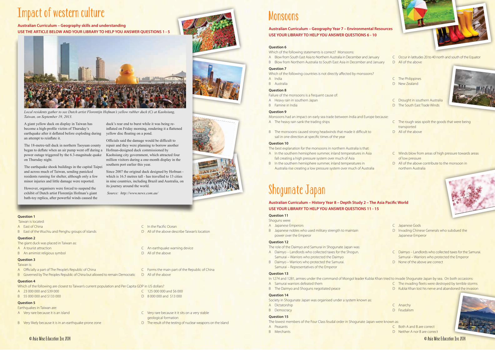
A giant yellow duck on display in Taiwan has become a high-profile victim of Thursday’s earthquake after it deflated before exploding during an attempt to reinflate it.
The 18-metre-tall duck in northern Taoyuan county began to deflate when an air pump went off during a power outage triggered by the 6.3-magnitude quake on Thursday night.
The earthquake shook buildings in the capital Taipei and across much of Taiwan, sending panicked residents running for shelter, although only a few minor injuries and little damage were reported.
However, organisers were forced to suspend the exhibit of Dutch artist Florentijn Hofman’s giant bath-toy replica, after powerful winds caused the
duck’s rear end to burst while it was being re-inflated on Friday morning, rendering it a flattened yellow disc floating on a pond.
Officials said the damage would be difficult to repair and they were planning to borrow another Hofman-designed duck commissioned by Kaohsiung city government, which attracted four million visitors during a one-month display in the southern port earlier this year.
Since 2007 the original duck designed by Hofman - which is 16.5 metres tall - has travelled to 13 cities in nine countries, including Brazil and Australia, on its journey around the world.
Source: http://www.news.com.au/
Local residents gather to see Dutch artist Florentijn Hofman’s yellow rubber duck (C) at Kaohsiung, Taiwan, on September 19, 2013.
© Asia Wise Education Inc 2014 © Asia Wise Education Inc 2014

Where people live – Population density Australian Curriculum – Geography Year 7 – Unit 2 USE THE MAPS BELOW AND YOUR LIBRARY TO HELP YOU ANSWER QUESTIONS 16 - 20
Question 16Examine the two maps above. Which of the following statements is best supported by the maps above?A The area of lowest population density in Australia is in the south east C The area of highest population density in India is in the Deccan plateau B The area of highest population density in India is in the north of the country D Both A and B are correct
Question 17 Of the following reasons, which one best explains India’s largest area of high population density?A Plenty of water and fertile soils C It is near the coast which is good for trade B It is near high mountains which means it has a cooler climate D All of the above
Question 18Which common factor helps to explain the location of both India’s and Australia’s areas of highest population density?A Coastal areas are good for trading C Reliable water all year roundB Good defensive positions D Warm climate
Question 19Only one of the following statements is supported by the maps. Which one is it?A The population density of Australia and India is quite similar C The population density in India is much higher than in AustraliaB Australia has a smaller population, but higher population density than India D The maps use the same scale to show density in both countries
Question 20Which of the following is not a factor in calculating population density?A Land area C Age of the population B Number of people D Both A and B
India – significant beliefs - Sikhism Australian Curriculum – History Year 7 – Depth Study 3 - India USE YOUR LIBRARY TO HELP YOU ANSWER QUESTIONS 21 - 25
Question 21Sikhism can best be described as:A A Middle Eastern Philosophy founded in Iraq C An East Asian sect advocating Christianity B An Indian religion founded in the 15th Century D Indian political movement founded in the 17th Century
Question 22Followers of Sikhism are known as:A Seekers C Sikhs B Sheiks D None of the above
Question 23Followers of Sikhism call their faith:A “Punjabi”- Which means “The way of the State.” C “Nanak” – Which means “The way of God” B “Bhakti” – Which means “ The way of peace” D “Gurmat” – Which means “The Way of the Guru”
Question 24.Followers of Sikhism:A Cover their heads and have bare feet when worshipping C Believe in liberation through meditation B Believe in ten human Gurus D All of the above
Question 25Which of the following individuals is NOT a significant figure in the early history of Sikhism?A Gobind Singh C Guru Nanak B Maharishi Mahesh Yogi D Ram Das
ChronologyAustralian Curriculum – History Year 7 and Year 8 – Strand 2 Historical Skills USE YOUR LIBRARY TO HELP YOU ANSWER QUESTIONS 26 - 30
Question 26Pre-history is that period of time before:A The birth of Jesus Christ C The invention of writing B 4000BCE D The fall of the Roman Empire
Question 27We know that pre-history began at least 40 000 years ago because:A Old books from that time have been found C Hieroglyphics from that time tell the story of Moses B Archaeologists have dated rock paintings and artefacts from that time D Cuneiform writing dating to that period has been found
Question 28The Sumerian, Egyptian and Indus civilizations shared which of the following features?A They all existed in arid areas C They all existed before the first Chinese empire B They all were located near major rivers D All of the above are true
Question 29Asia has had many large empires. Which of the following lists the events in the correct order from oldest to most recent?A Maurya Empire, Mongol Empire, Ottoman Empire C Khmer Empire, Mongol Empire, Maurya Empire B Mughal Empire, Mongol Empire, Ottoman Empire D Japanese Empire, Mughal Empire, Khmer Empire
Question 30From the following statements choose the one that is true.A The Mongol and Mughal empires were established before C The Khmer, Mongol and Mughal empires all existed at the birth of Jesus Christ the same time B The Greek and Maurya empires existed before the birth of Jesus Christ D All of these statements are correct and the Mongol and Khmer empires after the birth of Jesus Christ
© Asia Wise Education Inc 2014 © Asia Wise Education Inc 2014
Location – SE AsiaAustralian Curriculum – History and Geography skills and understanding USE YOUR LIBRARY AND ATLAS TO HELP YOU ANSWER QUESTIONS 36 - 40
Question 36All of the following are mountain ranges in South East Asia except the:A Elephant Mountains C Arakan Mountains B Annamite Mountains D Western Ghats
Question 37The longest rivers of South East Asia are the Irrawaddy and Mekong. They flow into which bodies of water respectively?A Andaman Sea and Bay of Bengal C Andaman Sea and the South China Sea B Indian Ocean and Gulf of Thailand D Bay of Bengal and the Gulf of Tonkin
Question 38Which statement about the Salween and Mekong is correct?A The capital cities of Cambodia, Laos and Thailand are located on them C Both rivers have their source in China B The Salween is longer than the Mekong D Both these rivers are considered sacred by Buddhists
Question 39Thailand is a major producer of rice. Rice is grown in preference to wheat because:A There is plenty of water for irrigation C Rice needs very high humidity to grow well B The cooler climate is suitable for growing rice D There are lots of people to work in the fields
Question 40Of the following countries, which one is not considered part of South East Asia?A Vietnam C Malaysia B South Korea D The Philippines
China – ConfuciusAustralian Curriculum – History Year 7 – Depth Study 3 USE YOUR LIBRARY TO HELP YOU ANSWER QUESTIONS 41 - 45
Question 41Confucius can best be described as a:A Deity C Teacher B King D Revolutionary
Question 42Confucius believed that all people:A Had the ability to improve themselves through learning C Should devote their lives to himB Were completely unable to change their lives D All of the above
Question 43Confucius was born in the year – in the State of - in the country -A 479 BC, Lu, Thailand C 479 AD, Kong, China B 551 BC , Kong, China D 551 BC, Lu, China
Question 44Confucius was a master of “The six arts”. These were:A Ritual, music, archery, charioteering, calligraphy, and arithmetic C Poetry, writing, peace, meditation, philosophy and sportB Warfare, chess, archery, politics, mathematics and astronomy D Music, poetry, chess, fireworks, sport and peace
Question 45Which of the following statements about Confucius is false?A Confucious died in 479 BC C Confucius wanted to improve the lives of others by educating them B Confucius was seen as a God in China during his lifetime D Confucius was in his 70s when he died
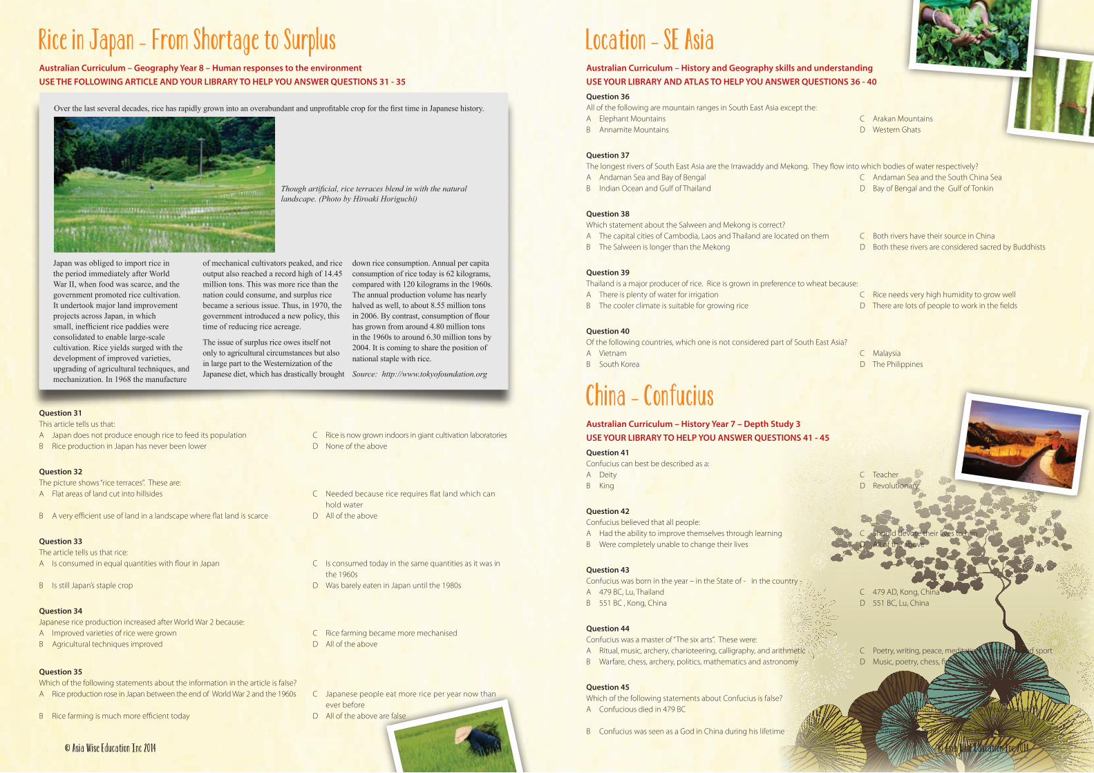
Japan was obliged to import rice in the period immediately after World War II, when food was scarce, and the government promoted rice cultivation. It undertook major land improvement projects across Japan, in which small, inefficient rice paddies were consolidated to enable large-scale cultivation. Rice yields surged with the development of improved varieties, upgrading of agricultural techniques, and mechanization. In 1968 the manufacture
of mechanical cultivators peaked, and rice output also reached a record high of 14.45 million tons. This was more rice than the nation could consume, and surplus rice became a serious issue. Thus, in 1970, the government introduced a new policy, this time of reducing rice acreage.
The issue of surplus rice owes itself not only to agricultural circumstances but also in large part to the Westernization of the Japanese diet, which has drastically brought
down rice consumption. Annual per capita consumption of rice today is 62 kilograms, compared with 120 kilograms in the 1960s. The annual production volume has nearly halved as well, to about 8.55 million tons in 2006. By contrast, consumption of flour has grown from around 4.80 million tons in the 1960s to around 6.30 million tons by 2004. It is coming to share the position of national staple with rice.
Source: http://www.tokyofoundation.org
Over the last several decades, rice has rapidly grown into an overabundant and unprofitable crop for the first time in Japanese history.
Though artificial, rice terraces blend in with the natural landscape. (Photo by Hiroaki Horiguchi)
Rice in Japan - From Shortage to SurplusAustralian Curriculum – Geography Year 8 – Human responses to the environment USE THE FOLLOWING ARTICLE AND YOUR LIBRARY TO HELP YOU ANSWER QUESTIONS 31 - 35
Question 31This article tells us that:A Japan does not produce enough rice to feed its population C Rice is now grown indoors in giant cultivation laboratories B Rice production in Japan has never been lower D None of the above
Question 32The picture shows “rice terraces”. These are:A Flat areas of land cut into hillsides C Needed because rice requires flat land which can hold waterB A very efficient use of land in a landscape where flat land is scarce D All of the above
Question 33The article tells us that rice:A Is consumed in equal quantities with flour in Japan C Is consumed today in the same quantities as it was in the 1960s B Is still Japan’s staple crop D Was barely eaten in Japan until the 1980s
Question 34Japanese rice production increased after World War 2 because:A Improved varieties of rice were grown C Rice farming became more mechanised B Agricultural techniques improved D All of the above
Question 35Which of the following statements about the information in the article is false?A Rice production rose in Japan between the end of World War 2 and the 1960s C Japanese people eat more rice per year now than ever before B Rice farming is much more efficient today D All of the above are false
© Asia Wise Education Inc 2014 © Asia Wise Education Inc 2014
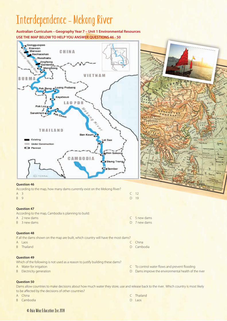
Interdependence – Mekong RiverAustralian Curriculum – Geography Year 7 – Unit 1 Environmental Resources USE THE MAP BELOW TO HELP YOU ANSWER QUESTIONS 46 - 50
Source: http://www.savethemekong.org
Question 46According to the map, how many dams currently exist on the Mekong River?A 3 C 12 B 9 D 19
Question 47According to the map, Cambodia is planning to build:A 2 new dams C 5 new dams B 3 new dams D 7 new dams
Question 48If all the dams shown on the map are built, which country will have the most dams?A Laos C China B Thailand D Cambodia
Question 49Which of the following is not used as a reason to justify building these dams?A Water for irrigation C To control water flows and prevent flooding B Electricity generation D Dams improve the environmental health of the river
Question 50Dams allow countries to make decisions about how much water they store, use and release back to the river. Which country is most likely to be affected by the decisions of other countries?A China C Thailand B Cambodia D Laos
© Asia Wise Education Inc 2014