the basics of geography - 6th social studies · book: longitude: the true story of a lone genius...
TRANSCRIPT

For many people, the mention of geography
conjures up visions of filling in names of states
or countries on blank map or correctly plotting
the latitude and longitude of a location on a
globe.
While this information is useful, in today's
global world, geography is much more than
learning maps and locations. It is understanding
the context of the people, history, culture,
environment and nature associated with
places, as well as the interpretation of the past
and application to the future.
Our Trekking the Planet expedition seeks to
raise awareness of geography education by
highlighting all these factors as we travel
around the world.
Our future weekly education modules will
provide an overview of our current location
(including its latitude and longitude), as well as
background on history, culture, environment
and nature.
The Basics of Geography
Education Module #1 Pre Trip - January 9, 2012 Page 1
"There sat the poor little fellow, with his sister on his lap, and he sang to her all the songs he knew;
and he glanced the while from time to time into the geography-book that lay open before him. By the
next morning he was to have learnt all the towns in Zealand by heart, and to know about them all that
is possible to be known." -- The Dream of Little Tuk (Andersen's Fairy Tales) - Hans Christian Andersen
source: Onlinepictures.org
This Pre Trip Module will focus on geography
basics. Understanding these basics is the first
step to learning about geography and gaining
better knowledge of our world.
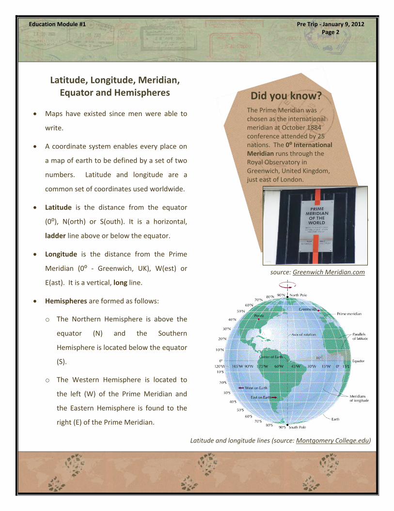
Maps have existed since men were able to
write.
A coordinate system enables every place on
a map of earth to be defined by a set of two
numbers. Latitude and longitude are a
common set of coordinates used worldwide.
Latitude is the distance from the equator
(0⁰), N(orth) or S(outh). It is a horizontal,
ladder line above or below the equator.
Longitude is the distance from the Prime
Meridian (0⁰ - Greenwich, UK), W(est) or
E(ast). It is a vertical, long line.
Hemispheres are formed as follows:
o The Northern Hemisphere is above the
equator (N) and the Southern
Hemisphere is located below the equator
(S).
o The Western Hemisphere is located to
the left (W) of the Prime Meridian and
the Eastern Hemisphere is found to the
right (E) of the Prime Meridian.
Latitude, Longitude, Meridian, Equator and Hemispheres Did you know?
Latitude and longitude lines (source: Montgomery College.edu)
Education Module #1 Pre Trip - January 9, 2012 Page 2
The Prime Meridian was chosen as the international meridian at October 1884 conference attended by 25 nations. The 0⁰ International Meridian runs through the Royal Observatory in Greenwich, United Kingdom, just east of London.
source: Greenwich Meridian.com

John Harrison and his H4 Chronometer – (personal
library)
A Short Longitude History and Overview
Historically, sailors found their latitude location using the position
of the stars. However, thousands of ships and sailors were lost
because longitude could not be accurately determined.
The British government passed an act in 1714 to award the
equivalent of several million dollars in today's currency to the
person who could design a "practical and useful" means of
determining longitude.
John Harrison, a man without formal education or training, built
several clocks to solve the problem and was awarded the design
prize in 1773.
Education Module #1 Pre Trip - January 9, 2012 Page 3
source: Free Printable Maps.com
In order to determine the current longitude position, sailors carried Harrison's clock, set to their "home
time". At the moment that the sun in their current location was at the highest point (noon), the sailor
compared that to the "home time" clock. The difference between the two times equaled the distance
travelled - 15° for every hour of time change.
"Home Time" 3pm
45° Travelled (minus 3 hours)
Noon

x
HEADLINESUB-HEAD
MONTH, YEAR VOL # ISSUE #
Delete box or place a cption here.
Delete box or place a caption here.
Continue newsletter text here. Continue newsletter text
here. Continue newsletter text here. Continue newsletter
text here. Continue newsletter text here. Continue
newsletter text here. Continue newsletter text here.
Continue newsletter text here. Continue newsletter text
here. Continue newsletter text here. Continue newsletter
text here.
Continue newsletter text here. Continue newsletter text
here. Continue newsletter text here. Continue newsletter
text here. Continue newsletter text here. Continue
newsletter text here.
Continue newsletter text here. Continue newsletter text
here. Continue newsletter text here. Continue newsletter
text here. Continue newsletter text here. Continue
newsletter text here. Continue newsletter text here.
Continue newsletter text here. Continue newsletter text
here. Continue newsletter text here. Continue newsletter
text here. Continue newsletter text here. Continue
newsletter text here. Continue newsletter text here.
Continue newsletter text here.
HEADLINE SUBHEAD. SUBHEAD.
SUBHEAD. SUBHEAD.
From the Basics to our Current World
More Information
http://en.wikipedia.org/wiki/Geographic_coordinate_system
Book: Longitude: The True Story of a Lone Genius Who Solved
the Greatest Scientific Problem of His Time” By Dava Sobel
Education Module #1 Pre Trip - January 9, 2012 Page 4
Armed with geography basics of latitude, longitude, meridian, equator and hemispheres, we now can
move on from learning about places to understanding our world.
Several models of the study of geography have been created by education groups; the next Pre Trip
Module will explore these and how Trekking the Planet will present geography educational material
during our expedition.
For one last look at latitude and longitude, click on the Google Map image below to look up
combinations around the world and find your own locations.
Our Partners
17 S 178 E 59 N 11 E
51 N 0W 38 S 145 E
34S 18E 41 N 29 E
13 N 101 E 34 S 58 W
1N 104 E 34 N 118 W
To enter combinations, use a ‘-‘ in front of south
latitudes or west longitudes. For example, 34 S, 58 W
would be entered as -34, -58 and 1 N, 104 E would be
entered as 1, 104.