the brief for the maintenance and/or installation and…
TRANSCRIPT

Southwest Regional Coastal Monitoring Programme Brief - Hydrodynamics
1
THE BRIEF FOR THE MAINTENANCE AND/OR INSTALLATION AND/OR
PROVISION OF HYDRODYNAMIC EQUIPMENT
Scheme Title Southwest Regional Coastal Monitoring Programme
Employer’s Address Forde House, Newton Abbot, Devon TQ12 4XX
Nominated Employer’s
Representative Mr Simon Humphry
Survey Title Maintenance and/or installation and/or provision of hydrodynamic
equipment
Purpose of Survey
The hydrodynamic network is used as a part of a long-term programme
of coastal monitoring, to analyse coastal processes and provide data
for operational and strategic shoreline management
Specification
Regional Coastal Monitoring Programmes Specification for
maintenance and/or installation and/or provision of hydrodynamic
equipment v1.0
Delivery Schedule
The delivery schedule for assumption of full responsibility for the
network of existing instrumentation is 01 April 2016 or within 3
calendar months of award of contract, whichever is the later
Tender Submission Date See the invitation to tender letter
Contract Completion
Date 31 March 2021
Known Hazards
The Employer is unaware of any special hazards other than those
normally associated with offshore and onshore instrumentation
deployment and maintenance. The Consultant shall carry out a full Risk
Assessment before each deployment/maintenance visit and shall
prepare a Safe System of Working based on the Assessment. A copy
shall be forwarded to the Employer’s Representative. The Consultant’s
attention is drawn to the desirability, among other things, of
monitoring weather conditions and of notifying the Coastguard of the
deployment/maintenance activities.
Site Conditions/
Restrictions, Access and
Public Relations
A letter of introduction will be provided which should be presented as
a matter of course, and without it being demanded, at all meetings
with landowners or the public
This Brief provides details specific to instrumentation which shall be maintained (including
unscheduled maintenance) and/or deployed and/or provided according to the Specification.

Southwest Regional Coastal Monitoring Programme Brief - Hydrodynamics
2
1. Variations to Specification
There are no variations to the Specification.
2. Phased assumption of responsibility for continuity of data and of unscheduled
maintenance
There will be a phased programme of transfer of responsibility from the Employer's representative to
the Consultant during the 3 months prior to the Delivery Schedule. It is crucial that continuity of data
is maintained during this period and that any data losses are kept to a minimum. If required, the
Employer's representative will be available to accompany the Consultant to a half day's visit to each
shore station, to aid the transfer of responsibility.
The Consultant will provide in the method statement a procedure for how the transfer of responsibility
will be achieved and a programme for assuming responsibility for all sites by the Delivery Schedule.
3. Equipment spares
An extensive stock of spares for the deployed equipment is held by the Employer, as listed in the
schedule (Appendix I). The Consultant will be expected to liaise with and co-operate with the
Employer's representative in Hampshire to arrange a phased hand-over of the spares. This is to ensure
that sufficient spares are available to both the Consultant and the Employer's representative during
the 3 month period prior to the Consultant assuming responsibility for the network.
4. Existing deployments
The locations listed in Table 1 and shown in Figure 1 have instruments deployed, for which the
Consultant will become fully responsible by the Delivery schedule date. Full details of the equipment
at each site are given in the Schedule (Appendix 1). The wave buoys are Datawell Directional
Waverider Mk III (DWR) moored using Datawell's shallow water mooring (deep water mooring at St
Mary’s Sound) and use HF radio transmission to shore station. The shore stations will continue to host
equipment and all have a phone line and broadband installed. All existing equipment has been
maintained according to the manufacturer's recommendations and in accordance with the
Specification. It can be assumed that all deployed equipment will be operational when the Consultant
assumes responsibility for it.
Where indicated in Table 1, a display of real-time wave/tide/met/other parameters, customised to
the shore station host's requirements, shall be provided and maintained at the shore station.
Where receiving/logging/data transfer systems for the DWR's are integrated with those for other
wave/tide/met/ARGUS/other data, any changes to the shore station must maintain the service to the
other equipment.
All Consultant's staff who work on the Severn Bridge (Second Severn Crossing) wave/tide gauge must
undergo, at the Consultant's expense, a half day's training for access and evacuation procedures for
the SSC. The training shall be arranged directly with the operations staff of the Second Severn
Crossing. No photographs of the bridge or the installation must be published or made publicly
available.

Southwest Regional Coastal Monitoring Programme Brief - Hydrodynamics
3
Instrument Site name Approximate
Location Shore station
Approx. service intervals/
due Comments
DWR Chesil 50o 36.16'N 02o 31.38'W
Weymouth & Portland National Sailing Academy
6 months* Apr 2016
Shore station is integrated with Weymouth DWR and Portland met station, both of which are the responsibility of the Southeast Regional Coastal Monitoring Programme
DWR West Bay 50o 41.60'N 02o 45.00'W
West Bay Harbour Master’s office
6 months* Apr 2016
Data display
Etrometa West Bay Harbour
50o 42.53'N 02o 45.85'W
9 months Oct 2016
Met station 50o 42.64'N 02o 45.83'W
REX Exmouth Exmouth Harbour Master’s office
9 months Nov 2016
Data display
DWR Dawlish 50° 34.78'N
03° 25.05'W
Beach office 6 months Jul 2016
Data display
DWR Tor Bay 50° 26.00'N
03° 31.10’W
Torbay Harbour Master’s office
6 months Apr 2016
Data display
DWR Start Bay 50o 17.54'N
03o 37.00'W
The shore station is in an outbuilding of a private dwelling. Details will be provided to the Consultant on award of contract
6 months Jun 2016
Data display. An ARGUS system is owned by the University of Plymouth but maintained by the Consultant. The system is integrated into the DWR shore station and shares the broadband line
DWR Looe Bay 50° 20.32'N
04° 24.65'W
Looe Coastguard station 6 months* June 2016
Data display
Met station 50° 20.70'N
04° 27.17'W
9 months Sep 2016
DWR Porthleven 50o 03.76'N
05o 18.48'W
Penzance Harbour Master’s office
6 months Sep 2016
Data display
DWR Penzance 50o 06.86'N
05o 30.18'W
6 months Sep 2016

Southwest Regional Coastal Monitoring Programme Brief - Hydrodynamics
4
Instrument Site name Approximate
Location Shore station
Approx. service intervals/
due Comments
Etrometa Port Isaac 50o 35.65'N 04o 50.06'W
Port Isaac aquarium 9 months Additional task is cleaning and maintenance of navigation adjacent to step gauge. Data display.
DWR St Mary’s
Sound
49o 53.52'N
06o 18.73'W
Coastguard Tower 6 months Jul 2016
DWR also has Orbcomm satellite as back-up. Data display at the Beach office in St Mary’s
DWR Perranporth 50o 21.20'N
05o 10.53'W
Youth Hostel, Droskyn Point 6 months May 2016
Data display. An ARGUS system and met station are owned by the University of Plymouth but maintained by the Consultant. Both systems are integrated into the DWR shore station computer and share the broadband line. The met data will be forwarded to the project’s website. The shore station is also a receiving station for Wave Hub DWR.
DWR Bideford Bay 51° 03.49'N
04° 16.61'W
Appledore RNLI 6 months Aug 2016
Data display
DWR Minehead 51o 13.63'N
03o 28.15'W
Harbour Master’s office 6 months* Aug 2016
Data display
DWR Weston Bay 51° 21.22'N
03° 01.10'W
Beach office 6 months Sep 2016
Data display
REX Severn Bridge
51° 34.46'N 02° 42.00'W
Engineer’s office 9 months Dec 2016
Additional task is maintenance of fog horn over-ride system, linked to tide data. Data display in SSC office. Further data display in Gloucester Harbour Board office, with display integrated with GHB’s Ohmex tide gauge.
Table 1: Location of existing deployments *may need additional cleaning visit every 3-4 months due to heavy bio-fouling. REX = Rosemount WaveRadar
REX; met stations comprise any of air temperature, wind speed, gust speed, wind direction, barometric pressure, rainfall, RH, UV, sunshine

Southwest Regional Coastal Monitoring Programme Brief - Hydrodynamics
5
Figure 1: Location of existing deployments

Southwest Regional Coastal Monitoring Programme Brief - Hydrodynamics
6
5. New deployments
There are no planned new deployments at present.
6. Instrument/buoy lettering
The wording to be used on a wave buoy is:
02380 598467
NO MOORING
Channel Coastal Observatory
On award of contract, however, the telephone number shall be amended to that of the Consultant's
24-hour contact number. The revised telephone number need only be applied to new deployments
or following a service visit.
7. Additional tasks
Additional tasks are required at Port Isaac and Severn Bridge, as listed in Table 1.
8. Vessel costs for unscheduled maintenance
Vessel costs for unscheduled maintenance visits are expected to be kept to a minimum, and not to
exceed £1,000 per (12 hour) day. Only in exceptional circumstances will the Employer agree to vessel
costs exceeding this sum, which must be authorised in advance by the Employer.
9. Technical Requirement
Required data shall be delivered within 4 weeks of the activity. Deployment/service reports shall be
delivered quarterly.
Southwest Regional Coastal Monitoring Programme Brief - Hydrodynamics
7
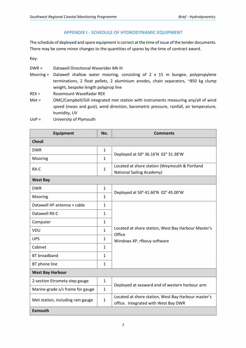
APPENDIX I - SCHEDULE OF HYDRODYNAMIC EQUIPMENT
The schedule of deployed and spare equipment is correct at the time of issue of the tender documents.
There may be some minor changes to the quantities of spares by the time of contract award.
Key:
DWR = Datawell Directional Waverider Mk III
Mooring = Datawell shallow water mooring, consisting of 2 x 15 m bungee, polypropylene
terminations, 2 float pellets, 2 aluminium anodes, chain separators, ~850 kg clump
weight, bespoke length polyprop line
REX = Rosemount WaveRadar REX
Met = OMC/Campbell/Gill integrated met station with instruments measuring any/all of wind
speed (mean and gust), wind direction, barometric pressure, rainfall, air temperature,
humidity, UV
UoP = University of Plymouth
Equipment No. Comments
Chesil
DWR 1 Deployed at 50o 36.16'N 02o 31.38'W
Mooring 1
RX-C 1 Located at shore station (Weymouth & Portland
National Sailing Academy)
West Bay
DWR 1 Deployed at 50o 41.60'N 02o 45.00'W
Mooring 1
Datawell HF antenna + cable 1
Located at shore station, West Bay Harbour Master’s
Office
Windows XP, rfbouy software
Datawell RX-C 1
Computer 1
VDU 1
UPS 1
Cabinet 1
BT broadband 1
BT phone line 1
West Bay Harbour
2-section Etrometa step gauge 1 Deployed at seaward end of western harbour arm
Marine-grade s/s frame for gauge 1
Met station, including rain gauge 1 Located at shore station, West Bay Harbour master’s
office. Integrated with West Bay DWR
Exmouth

Southwest Regional Coastal Monitoring Programme Brief - Hydrodynamics
8
REX 1 Due for deployment Oct 2015
S/S frame for REX 1
Computer 1
Located at shore station, Exmouth Marina Harbour
office
VDU 1
UPS 1
Cabinet 1
BT broadband 1
BT phone line 1
Dawlish
DWR 1 Deployed at 50° 34.78'N 03° 25.05'W
Mooring 1
Datawell HF antenna + cable 1
Located at shore station, Dawlish beach office
Windows XP, rfbuoy
Datawell RX-C 1
Computer 1
VDU 1
UPS 1
Cabinet 1
BT broadband 1
BT phone line 1
Tor Bay
DWR 1 Deployed at 50° 26.00'N 03° 31.10’W
Mooring 1
Datawell HF antenna + cable 1
Located at shore station, Tor Bay Harbour Master’s
office
Windows XP, rfbuoy
Datawell RX-C 1
Computer 1
VDU 1
UPS 1
Cabinet 1
BT broadband 1
BT phone line 1
Start Bay
DWR 1 Deployed at 50o 17.54'N 03o 37.00'W
Mooring 1
Datawell HF antenna + cable 1 Located at shore station

Southwest Regional Coastal Monitoring Programme Brief - Hydrodynamics
9
Datawell RX-C 1 Windows XP, rfbuoy
Computer 1
VDU 1
UPS 1
Cabinet 1
BT broadband 1
BT phone line 1
UoP ARGUS camera system 1
Looe Bay
DWR 1 Deployed at 50° 20.32'N 04° 24.65'W
Mooring 1
Datawell HF antenna + cable 1
Located at shore station, Looe Coastguard
Windows XP, rfbuoy
Datawell RX-C 1
Computer 1
VDU 1
UPS 1
Cabinet 1
BT broadband 1
BT phone line 1
Met station 1
Porthleven
DWR 1 Deployed at 50o 03.76'N 05o 18.48'W
(shore station at Penzance) Mooring 1
Penzance
DWR 1 Deployed at 50o 06.86'N 05o 30.18'W
Mooring 1
Datawell HF antenna, cable +
cable splitter 1
Located at shore station, Penzance Harbour Master’s
office
Windows XP, rfbuoy
Datawell RX-C 2
Computer 1
VDU 1
UPS 1
Cabinet 1
BT broadband 1

Southwest Regional Coastal Monitoring Programme Brief - Hydrodynamics
10
BT phone line 1
St Mary’s Sound
DWR 1 Deployed at 49o 53.52'N 06o 18.73'W
Datawell 30 m mooring 1
Datawell HF antenna + cable 1
Located at shore station, Coastguard tower
Additional VDU at St Mary’s beach office
Windows XP, rfbuoy
Datawell RX-C 1
Computer 1
VDU 1
UPS 1
Cabinet 1
BT broadband 1
BT phone line 1
Perranporth
DWR 1 Deployed at 50o 21.20'N 05o 10.53'W
Mooring 1
Datawell HF antenna + cable 1
Located at shore station, Youth Hostel, Droskyn Point
Windows XP, rfbuoy
Datawell RX-C 1
Computer 1
VDU 1
UPS 1
Cabinet 1
BT broadband 1
BT phone line 1
UoP met station 1
UoP ARGUS camera system 1
Port Isaac
4-section Etrometa step gauge 1
Located on outer breakwater
Marine-grade galvanised frame
for gauge 1
Solar powered VHF transmitter 1
Batteries 2
Navigation light 1
Weatherproof cabinet
VDU 1 Located at shore station, Port Isaac aquarium

Southwest Regional Coastal Monitoring Programme Brief - Hydrodynamics
11
UPS 1 Windows XP
Cabinet 1
BT broadband 1
BT phone line 1
VHF receiver 1
Bideford Bay
DWR 1 Deployed at 51° 03.49'N 04° 16.61'W
Mooring 1
Datawell HF antenna + cable 1
Located at shore station, Appledore RNLI
Windows XP, rfbuoy
Datawell RX-C 1
Computer 1
VDU 1
UPS 1
Cabinet 1
BT broadband 1
BT phone line 1
Minehead
DWR 1 Deployed at 51o 13.63'N 03o 28.15'W
Mooring 1
Datawell HF antenna + cable 1
Located at shore station, Minehead harbour Master’s
office
Windows XP, rfbuoy
Datawell RX-C 1
Computer 1
VDU 1
UPS 1
Cabinet 1
BT broadband 1
BT phone line 1
Weston Bay
DWR 1 Deployed at 51° 21.22'N 03° 01.10'W
Mooring 1
Datawell HF antenna + cable 1
Located at shore station, Weston beach office
Windows XP, rfbuoy
Datawell RX-C 1
Computer 1
VDU 1

Southwest Regional Coastal Monitoring Programme Brief - Hydrodynamics
12
UPS 1
Cabinet 1
BT broadband 1
BT phone line 1
Severn Bridge
REX 1 Deployed mid-span of Second Severn Crossing
S/S frame for REX 1
Computer 1
Located at shore station, SSC engineer’s office
Windows XP
VDU 1
UPS 1
Cabinet 1
BT broadband 1
BT phone line 1
Spare equipment
Rosemount WaveRadar REX 1 For REX
3 m step gauge section 1 For Etrometa step gauge
3 m step gauge frame 1
Datawell DWR Mk III 1 For DWR
15 m bungee
30 m bungee
3 kg pellet float
10 kg pellet float
Galvanised seabed shackle
S/S 12 mm shackle
Chain anode separator set
Chain anodes
Triangle anodes
Mooring chain
Rope termination
Radar reflector set
Battery pack
Safety triangle
Hatch cover screw

Southwest Regional Coastal Monitoring Programme Brief - Hydrodynamics
13
Hatch cover "O" ring
Hatch cover handle
BUFFIN antenna
GPS wire
HF antenna (32-36 MHz)
RX-C
Buoy finder 1