the brookland park historic district - church hill brookland park historic district.pdfthe brookland...
TRANSCRIPT

MENU
The Brookland Park Historic DistrictThe Brookland Park Historic District is composed of several late-nineteenthand early-twentieth subdivisions anchored by commercial development atNorth Avenue and Brookland Park Boulevard.
The Brookland Park Historic District
1. Introduction2. Early History3. Residential Development4. Commercial and Public Development5. Architectural Styles6. Maps7. Credit and Sources
Introduction
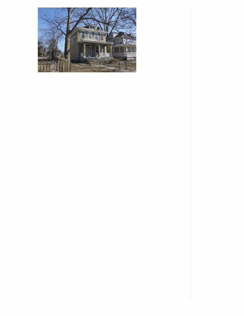
Brookland Park, the earliest and largest of the subdivisions in the BrooklandPark Historic District, was plated in the same year, 1890, as Barton Heights tothe south. However, because of its distance from the streetcar terminus thisarea was slower to develop and the lot sizes were smaller because thedevelopers did not think them to be as desirable as those closest to the trolley.
3007 Barton Avenue
Modest frame bungalows and American Foursquare houses, built in the early-twentieth century, surround the heart of this historic district at the crossing ofNorth Avenue and Brookland Park Boulevard. This intersection was theneighborhood’s’ early twentieth-century commercial center, and the pointwhere the streetcar tracks once turned west, linking other neighborhoods inRichmond’s Northside. Monumental heoclassical churches and school buildingsenhance the neighborhood, as do two, small, triangular public parks. Most ofthe streets are lined with sidewalks and mature trees. A secondary grid ofalleyways provides access to one-story frame garages and service sheds.
The Brookland Park Historic District is composed of several late-19th and early20th century subdivision on the Northside of Richmond. The largest andearliest of these subdivision is Brookland Park which began in 1890 as a jointventure of James H. Barton and Joseph M. Fourqurean. The neighborhoodgrew slowly as it was some distance from the brand new electric street carterminal in Barton Heights. Its growth spurted after 1911 when the Norwoodsubdivision joined Brookland Park to the Town of Barton Heights to the south.Belrose (191I), North Richmond Terrace (1913), and Alvista Heights (1914)continued the grid pattern and lot sizes established in Brookland Park asdevelopment moved further north of Brookland Park Boulevard. The lastsubdivision Woodrow Park (1924) filled in a small tract of land to the west ofBrookland Park.
The historic district’s northernmost boundary is Ladies Mile Road. The easternboundary is the Richmond-Henrico Turnpike and the steep ravine of Cannon’sBranch. Norwood Avenue and Lancaster Road define the district’s southernboundary and Griffin and Edgewood Streets define its western edge. The southand west boundaries, shared with the Barton Heights and Battery CourtHistoric Districts, are corporate definitions derived from the neighborhooddevelopment. They do not delineate a sharp change in neighborhood characteror architecture.
[top]
Early History
James H. Barton appeared on the Richmond business scene quite suddenly in1889 when he purchased farmland north of the city at the end of Second Streeton the “New North Mile Road” (North Avenue).
“I saw,” he said, “the finest piece of suburban landed property I ever beheld. It began
almost at the city limits, and included two hundred acres. From it the prettiest view
of the city that had come under my observation could be seen… I bought it and am

now putting into practice my scheme.
Advertisement – Times-Dispatch (January 1906)
Constructing a viaduct across the ravine between the city and this “highplateau, capable of presenting the most pleasant sights,” Barton connected hisnew town of Barton Heights to the city and soon (1894) had electric trolleysferrying his clients to new homes. In addition to his purchase of the heightsabove Bacon Quarter Branch that today bear his name, Barton with hisrelations Hattie C. Lamb (his sister) wife of T. Avery Lamb, and her brother-in-law Lawrence Lamb, began looking further north as well.
In February 1889, Barton and the two Lambs bought from two of the heirs ofEdward Griffin a total of 73 % acres to the west of the North Road. In 1884 the137-acre farm of Fendall Griffin had been divided among his heirs (the childrenof his son Edward Griffin (1795-1872) had been a delegate to the GeneralAssembly from Henrico County in the 1850s, and his property sat astride theBarton’s proposed development of the area north of present-day Battery Courtand Barton Heights. Today Fendall and Griffin Avenues memorialize this earlyownership. The remaining parcels of the Griffin estate were retained by EmmaBowe (Mrs. N. W.) and George Griffin, and would later constitute a major partof the Battery Court neighborhood.
James Barton and the Lambs had some competition in the development ofBrookland Park. Joseph M. Fourqurean, a successful dry goods merchant andpresident of the North Side Land Improvement Company, partnered withAugust F. Cordes (another Broad Street dry goods merchant in 1890 to open upOak Park, which was located across North Avenue from Barton and Lamb’sventure and south of Brookland Park Boulevard to Hooper Avenue. Fourqurean(died 1911) like a number of Richmond’s new merchants, had founded hisbusiness. Fourqurean Price & Company in 1865, in the ashes of the old capital.His long involvement in the city’s capitalist circles provided him with manyprominent associates.

The Northside Land Companys was simultaneously developing the land east ofthe Richmond Henrico Turnpike, today’s Highland Park. Like Barton thecompany constructed a viaduct (Fifth Street) over which another trolley linecarried Chestnut Hill’s residents to their new homes. Because of its greater tiesto the city’s power structure, the Northside Land Company also pitchedChestnut Hills to a higher income clientele.
By 1894 Brookland Park was laid out around the intersection of North Roadand (a newly cut through) Brookland Park Boulevard which connected ChestnutHill to the east to the Brook Pike on the west. It extended north to GladstoneStreet (then Jones), east to the Richmond Henrico Turnpike, west to GriffinAvenue and south to Norwood Avenue (then Rogers Street). Lots weregenerally smaller the further they were from the trolley lines, which stopped atthe Cedar Tree (Kersting Street, later Cedar Tree Street, today Graham Road).
In the same year Barton District was created within Henrico County’sBrookland District. It included Barton Heights, Brookland Park (Barton &Lamb) and Joseph M. Fourqurean’s North Street subdivision. The county’ssupervisors appointed Board of Improvements Commissioners for theNorthside district in 1898: J. M. Fourqurean, A.F.Mosby, W.H.Dunn,C.W.Wingfield and C.W.Vaughan. This body had authority to direct locallyraised tax monies to capital improvement projects in the area.
Advertisement – Times-Dispatch (May 16, 1909)
But Fourqurean’s and Barton’s Brookland Park venture was premature in 1890.Perhaps the lots were too small at 30 feet and the distance from the trolley toofar to compete with Barton Heights proper. The 1901 Henrico atlas shows 28dwellings and one church (Barton Heights Methodist at 2819-21 North Avenuebetween Essex & Hooper 1893) compared with the 120 houses in the town ofBarton Heights. Other developers and savvy property owners likewise heldonto the lands between Barton’s two ventures for the next decades. It was notuntil 1911 that subsequent suburban development closed the gap betweenBarton Heights and Brookland Park.
[top]
Residential Development
It would be John B. Swartwout who opened the land between the two originalBarton ventures (Barton Heights and Brookland Park) as Norwood in 1911(between Hooper and Graham), having acquired the large parcels on the eastside of North Avenue after 1904 from Julia A. Schultz (widow of J.B.) andFranklin B.Traylor. Swartwout (1882-1947) was a lawyer and real estatedeveloper. A native of Port Jervis, New York he was reared in Richmond andparticipated in a number of real estate ventures in addition to maintaining his

law practice. In the far west end of the city, Swartwout developed the TuckahoeApartments in the 1920s, which continue to overlook the Country Club ofVirginia. During the development of Norwood, J. B. Swartwout made his homeon North Avenue just outside the limits of the town of Barton Heights.
2503 North Avenue – the oldest house in the district
His house (2503 North Avenue) faces Overbrook Road in the center of group ofSpanish Colonial Villas constructed in the 1920s. Swartwout’s house is amodified Greek Revival House and appears to be the oldest surviving structurein the District. From its age it appears to be the manor house of the Schultzproperty that Swartwout had acquired after 1904.
Among the residents of Brookland Park was J.F. Pizzini at 3110 (910, 1610)North Avenue, in 1906 publisher of the Catholic Visitor, and owner of Pizzini’sShow Prints on 8th Street. North of Essex on Barton Avenue at 1309 (2808)lived Frank H. Nott (1865-1939) whose company dealt in recycled materials(junk). His wife Edith Emms continued to head the company and live in theirsubstantial house until her death in 1950.
The Bickerstaff family whose business was automotive supplies (J. L.Bickerstaff & Sons at 1811 East Main Street) maintained a neighborhoodpresence in the years before World War II in the Alvista Heights section. AlvistaHeights was developed after 1914 along the westem slope beside the RichmondHenrico Turnpike, north of Brookland Park Boulevard and below GladstoneStreet. In 1924 J. L. Bickerstaff Jr. lived in the original corporation of BartonHeights at 2206 Lamb Avenue. John J.Bickerstaff lived north of BrooklandPark Boulevard at 3029 Lamb. By 1932 John J. had moved to 3118 Lamb andremained there into the 1940′s. James H. Bickerstaff also lived on Lamb (at3129) in 1932, but had moved a block away to 3110 Woodrow by 1940, bywhich time he had assumed the presidency of the family business.
Other residents of Woodrow Park developed in 1924 included J. Hay Taliaferro(clerk at Kingan & Co, Provisioners) at 3215 Woodrow. In 1932 John M.Valentine, Jr. had lived at 3112 Woodrow Avenue, while the senior Valentine,of the long established auction house, lived further east on Brookland ParkBoulevard in Highland Park (1115 East).
North of Alvista Heights was North Richmond Terrace (1913) bounded on thesouth by Gladstone (Jones) Street and on the north by Ladies Mile and itsintersection with Cliff Avenue. Meredith Street is the lone cross street of thesubdivision, and like the other cross streets north of Brookland Park Boulevard,has no addresses on it. The area showed a good proportion of home ownershipin 1940. In that year and in the preceding decade Richmond City policedetective Lt. Daniel W. Duling lived at 3324 Barton Avenue near the edge of the

district. His son Frank Duling became the city’s chief of police in the 1960′s,and has remained a Northside resident on Brook Road.
Meredith Street memorializes the partnership of Meredith & Cocke whoselands also bordered the northern limits of Brookland Park. Similarly Garlandand Hanes Avenues recognize the ownership of Garland Hanes, whose landsonce lay north of Brookland Park Boulevard (Brook Pike) and principally east ofNorth Avenue.
[top]
Commercial and Public Development
During the 1920s and 1930s, as the subdivisions became more populated andthe streetcar line was extended to the north and west, commercial developmentflourished at the intersection of North Avenue and Brookland Park Boulevard.
2900 block of North Avenue (1990s)(Note the now demolished Brookland Inn to thefar left of the row of buildings.)
2900 block of North Avenue (2010)
It was at Brookland Park Boulevard that the trolley turned west to service otherneighborhoods. The 1922 City Directory lists only two commercial buildings onNorth Avenue – the North Avenue Market at 2927 and the Mills Company, Inc.,confectioners at 3000 – and none on Brookland Park Boulevard. By 1926 the2900 block of North Avenue and the 00 to 200 blocks of Brookland Park werefully developed with a variety of commerical establishments.
Trolley turning from North Avenue onto Brookland Park Boulevard
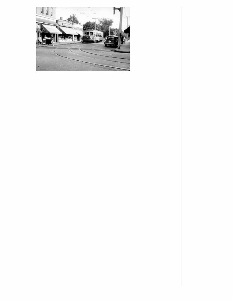
The directories lists several grocery stores, including the Great Atlantic andPacific Tea Company at 2912 North Avenue and 119 Brookland Park Boulevard.There was a restaurant, several bakeries and confectioners, barber shops, aflorist, tailors and shoe repair, a Chinese hand laundry and a hardware store. Itwas a shoping district that could satisfy all of the consumer needs of theNorthside residents.
North Avenue and Brookland Park Boulevard
The corner of North and Brookland Park is dominated by two large structures,the former Northside Branch of the City and State Bank and Trust Company,and the remaining half of the Brookland Inn (see above). The two-story, ArtDeco Brookland Theater breaks up the 100 block of Brookland Park while theNorthside Branch of the American National Bank commands the 200 block.
Brookland Theater
American National Bank
It is the public buildings that tell the story of the development of the BrooklandPark community, from its initial identity as a speculative suburb for the whitemiddle class to the presentday mixed-income, mixed-race community.
In 1896 the community was home to four white Protestant congregations: theframe Barton Heights Baptist Church(1892) stood at Virginia (Greenwood) andWickham streets. In 1922 a new masonry sanctuary was built at Hanes andNorwood, which today houses the First African Baptist Church.
First African Baptist Church

The original Barton Heights Methodist Church (1893) was on North Avenuebetween Essex and Hooper. In 1922, reflecting a change in the composition ofthe white population, the old building was sold to St. Paul Catholic (whoseornamental-block priests’ house continues to occupy the comer of Hooper andNorth). The Methodists built a new building at Garland Avenue in 1931, whichtoday houses the congregation of Garland Avenue Baptist Church.
St.Philip’s Episcopal Church
Epiphany Episcopal was originally located at 801 (2201) Barton Avenue atBattery Street. In 1932, as the Church of the Epiphany, it moved to a newCollegiate Gothic sanctuary on Hanes Avenue at Essex. When its congregationopted to move to Henrico County in 1960, the building was transferred to St.Philip’s Episcopal, an African American congregation formerly located on LeighStreet at St.James. The Overbrook Presbyterian Church building still stands onOverbrook at the southeast corner of Miller Avenue. Its name was changed toreflect its current predominantly African-American congregation, All SoulsPresbyterian Church.
[top]
Architectural Styles
In Brookland Park a remarkable consistency pervades the residentialarchitecture. Most houses are builder-designed American Foursquares withfeatures reflecting the Colonial Revival or Craftsman styles. The dominantbuilding use in the historic district is the single-family home; these houses,along with the duplexes that dot the neighborhood, are similar in scale,materials, character, and setback. Though a few larger Brookland Park houseswere constructed south of Brookland Park Boulevard, most are two stories,enclosing less than 2,000 square feet of finished living space. Most are framewith a single-story porch spanning the facade, and either Colonial Revival orCraftsman in style, moderate in scale, with understated materials and stylisticexpression.
The neighborhood’s primary residential streets run north and south,continuing the grid pattern established in Barton Heights, located south of thisdistrict. Very few buildings front on the east west cross streets, except atBrookland Park Boulevard. The relatively flat topography allows for anuninterrupted grid of long blocks at the neighborhood’s interior. A majority ofthe district’s noncontributing modern buildings are located at the eastern edge(see Clifton Street and Nomood Court) where the land falls sharply to theRichmond-Henrico Turnpike, resulting in irregularities in the street grid. Atthe northeast section of the neighborhood, smaller cottages and bungalowsedge the historic district along Cliff Avenue.

The neighborhood’s visual interest derives from the variety of commercialbuildings at its center and from the monumental churches and schools whichare focal points in the early suburban grid. The neighborhood’s commercialarea is anchored the masonry buildings on the south side of Brookland ParkBoulevard at North Avenue.
Across the Boulevard, on the north side of the intersection, at 2 East BrooklandPark Boulevard a one-story Moderne structure faces the comer with a curvedfront and an aluminum canopy projecting over the entry. At North Avenue andBrookland Park Boulevard many one and two-story commercial structuresrepresent a pared-down commercial vernacular, as seen in the former A&PGrocery Store at 2921 North Avenue. Other commercial buildings incorporatefeatures of the Spanish Colonial (see 101-113 West Brookland Park Boulevard)or Classical Revival styles, as seen in the former bank building at 201 WestBrookland Park Boulevard.
The historic district’s other landmarks-its schools and churches–representeither the Classical Revival or Gothic Revival styles.
J.E.B. Stuart Elementary School – 3101 Fendall Avenue
The district’s two publics chools are monumental buildingsin the ClassicalRevival style: North Side Junior High School (now Community High School) at201 E. Brookland Park Boulevard and J.E.B. Stuart Elementary School at 3101Fendall Avenue. The more understated St. Paul’s School building at 2811Fendall Avenue was constructed in the Colonial Revival style in 1923.
The 1922 First African Baptist Church (built as the Barton Heights BaptistChurch) is located at the intersection of Hanes and Norwood Avenues.Repeating a pattern established in Richmond’s other historic Baptist churches,this is a temple form Classical Revival building. The design of the GarlandAvenue Baptist Church (built as Barton Heights Methodist Church) at 2700Garland Avenue is heavily influenced by the Scottish Architect, James Gibbs(1683-1774) and forms an impressive terminus to the Norwood Avenue axis.
Greek Revival (ca. 1840)
The sole example of the Greek Revival style in the historic district is 2503North Avenue (pictured above). During the 1910s this was the home of [awyerJ. B. Swartwout, one of Brookland Park's early developers. This three-baydetached building appears to be the oldest structure in the early northRichmond suburbs. The Flemish bond brickwork has been painted and theoriginal porch and entry have been replaced with Colonial Revival elements(perhaps during Mr. Swarhrvout's ownership). At the first floor the original six-over-nine, floor-length windows and ramped hoods have been preserved, ashave the six-over-six second-story windows. The box cornice is enriched with

modillions and a crown molding. The projecting center bay of the house, whichcontains the primary entry, is articulated with a cross gable.
Italianate (ca. 1890-1910s)
Although the ltalianate-style dominated Richmond's urban architecture in thelast quarter of the nineteenth century, this style is not well represented in theBrookland Park Historic District. Typical ltalianate houses tended to have avertical emphasis with a parapeted facade shallow- pitched shed roofs,bracketed cornices, and a paneled frieze. Of the four examples of BrooklandPark's ltalianate buildings, the three-bay, two-story house at 3121 NorthAvenue has the greatest integrity. This two-story frame house retains a typicalbracketed and denticulated cornice and paneled frieze with sawn vents.Although modern shutters and a first-floor picture window have been added,the two-over-two second-floor windows have been preserved, as have the sawnbrackets and tumed columns of the three-bay front porch.
3121 North Avenue
Late Victorian (1890s-1900s)
The few Late Victorian-style buildings in Brookland Park are typically frame,detached, single- family houses that are vertically oriented, with less exuberantdecoration than the later Queen Anne examples. Some have steep pitchedmetal roofs, where others have a false mansard roof on the facade only.Brookland Park's scattered examples tend to be located in an 1890sdevelopment mapped as "Division of Barton and Fourqurean Land".
3008 Barton Avenue

3008 Barton Avenue is an example of this small scattering of stylisticallysimilar buildings. An L-shaped, house with weatherboard siding and a two-bayside entry porch, 3008 Barton originally had a cross-gable standing-seam metalroof. A paneled and bracketed three-sided bay announces the primary livingspace within, and supports a projecting bay holding a pair of narrow one-over-one sashes. A louvered bull's eye centered in the steep-pitched gable abovecompleted this handsome architectural flourish. The porch featured a spindlefrieze and turned columns and balusters. A recent renovation has eradicatedmost of this detail.
Queen Anne (1890s-1920s)
The few pure Queen Anne style houses in the Brookland Park Historic Districtare frame buildings, clad in weatherboard, with a mix of intersecting roof formsand angled bays. The remaining historic ornament is concentrated on theirporches where sawn brackets are combined with turned columns and balusters.In contrast with the neighboring Barton Heights Historic District where theQueen Anne style was dominant, in Brookland Park, Queen Anne styleattributes such as varied material textures, angled bays, and multiple roofforms are often fused with attributes of the Colonial Revival style. Examples ofthese stylistically-mixed houses include 2608 and 2702 Barton Avenue. Muchof the sawn-wood ornament that once adorned the neighborhood's QueenAnne style houses has been lost.
Colonial Revival (1910s-1940s)
The Colonial Revival style, characterized by simple massing, box cornices,molded casings, and generic details recalling American Colonial architecture,dominates Brookland Park's residentialarchitecture.
These houses, duplexes, and small apartment buildings (with four or fewerunits) are usually weatherboarded, rendered in stucco, or surfaced withgunnite. Their roofs are usually hipped with centered dormers. The more high-style Colonial Revival examples have pedimented doors or entryways, dentils ormodillions, and patterned upper windowsashes.
Nott House - 2808 Barton Avenue
Several prominent examples, such as the Nott House at 2808 Barton Avenueand the nearby house at 2812 Barton, Avenue were constructed in moldedconcrete block.The larger scale examples are found on Barton Avenue, particularly in theblocks south of Brookland Park Boulevard. These houses, at the core of theNorwood and Oak Park subdivisions, perpetuate the architectural themesestablished in the bigger houses of James Barton's earlier development, BartonHeights.

2800 block of Griffin Avenue
Much more common in the Brookland Park Historic District are the ColonialRevival Style houses built on the American Foursquare prototype, such as thoselining the 2800 and 2900 blocks of Griffin Avenue. These boxy,weatherboarded or stuccoed houses often have paired windows with patternedupper sashes. Their raised, one-story, two-bay porches have square or roundTuscan columns. Centered in their hipped, standing-seam metal roofs arehipped dormers.
Earlier (1910s) examples of this style tend to be south of Brookland ParkBoulevard. A majority of those north of Brookland Park Boulevard wereconstructed in the 1920s.
Bunglaw Craftsman (1900s-1930s)
Hundreds of examples of the Bungalow style are found in the Brookland ParkHistoric District. These builder-designed houses were constructed throughoutthe neighborhood. Like the district's Colonial Revival style houses, mostexamples of the Bungalow style are boxy American Foursquare houses surfacedwith stucco or gunnite. Most of the Bungalow Style houses are wood-frameconstruction with hipped or gable roofs and raised one-story, two-bay frontporches with prominent piers. The roof rafters are often exposed within deepeaves, asin the gable-roofed examples at 3118 and 3219 Barton Avenue, bothAmerican Foursquares. Many similar examples are found on Griffin, Fendall,Hanes, and Garland Avenues, the streets comprising the Brookland Parksubdivision.
3219 Barton Avenue

Commercial Style (1920s-1930s)
Generic Commercial style brick and stucco-faced buildings are concentrated inthe area spanning Fendall and Barton Avenues along East and West BrooklandPark Boulevard and in the 2900 block of North Avenue. These one-and-two-story buildings with their large, plate-glass storefronts have flat roofs withparapets and simple, geometric brick, stucco, or cast stone ornament. 2923North Avenue is an excellent examples of this style.
2929 North Avenue
After its 1920s construction this one-story building was the neighborhood A&Pgrocery store. When the A&P moved to larger facilities on Brookland ParkBoulevard, 2923 became home to a local bakery. Like the adjacent building at2919 North Avenue, 2923 has a brick facade and a ramped parapet.
Classical Revival (1920s)
The Classical Revival buildings of the Brookland Park Historic District are theneighborhood's landmarks. The most impressive of these, Barton HeightsBaptist Church (1922, at 2700 Hanes Avenue), Barton Heights MethodistChurch (ca. 1930s, at 2700 Garland Avenue), and Northside Junior HighSchool (1920s, at 201 East Brookland Park Boulevard) feature two-storyporticoes with pediments, full entablatures, raised basements, andmonumental stairs. The main entry to the junior high school is set within anenormous cast stone arch filled with an ornamental metal screen.
The most prominent feature of the J. E. B. Stuart Elementary School (3101Fendall Avenue), the historic district's other 1920s public school in the

Classical Revival style, is the three-story mass of the rounded auditoriumcentered in its facade. This red brick school is less monumental than theNorthside Junior High School building, but its classical moldings and two-storypaired pilasters convey dignity and seriousness of purpose.
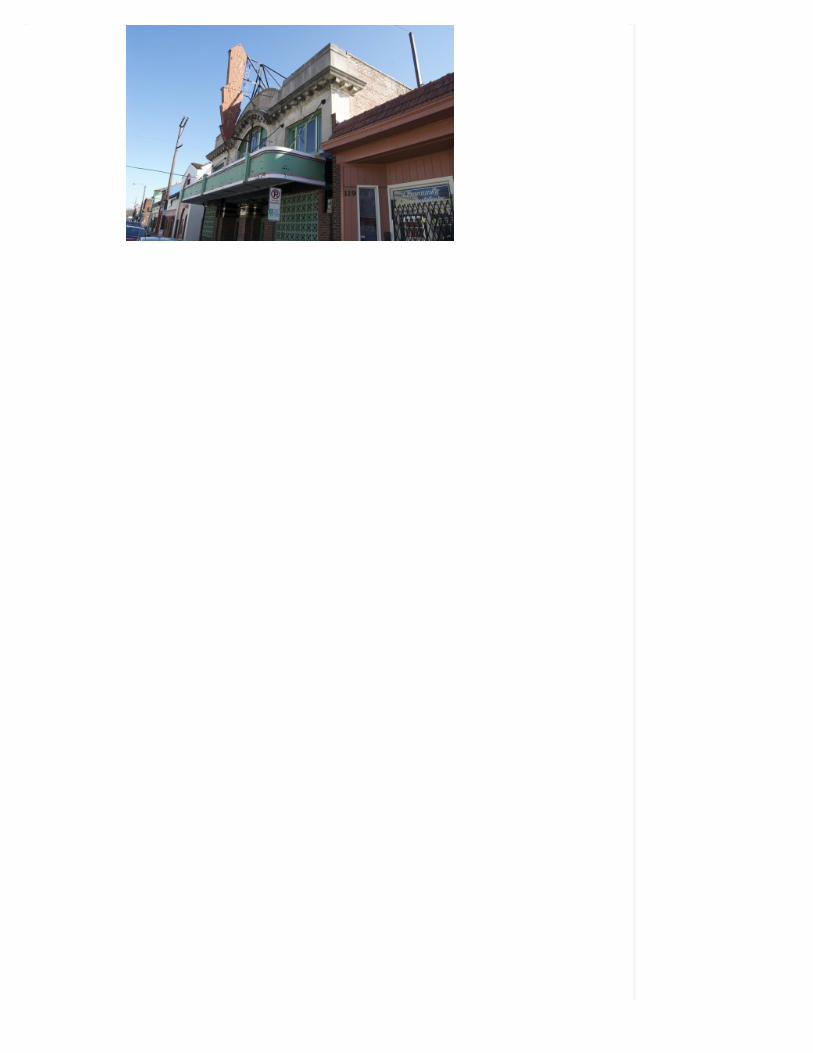
The small-scale Classical Revival bank building at 201 W. Brookland ParkBoulevard is an abandoned architectural jewel. Tuscan pilasters define thecorners of this two-story building. A molded metal entablature wraps thebuilding below the paneled parapet. The arched central entry is framed with anarchitrave consisting of alternating rounded and squared blocks, topped with asegmental pediment. One block further east at 115 West Brookland ParkBoulevard, the Brookland Theater incorporates an Art Deco marquee with amore playful adaptation of the Classical Revival style.
Gothic Revival (1920's)
Epiphany Episcopal (now St. Philip's Episcopal), at 2900 Hanes Avenue, is amodestly scaled redbrick church building with cast-stone Gothic Revivalornament. The building presents the sole example of this style in theBrookland Park Historic District. The church's corner entry tower, parapetedend walls, shallow buttresses and arched windows are capped or framed in caststone that mimics the ornament of English Gothic churches. W. LaumanRagland, a general contractor who was once mayor of Barton Heights, built thechurch in the early 1920s. The Epiphany Episcopal Church building isreminiscent of Ralph Adams Cram's widely acclaimed designs for the Universityof Richmond campus (1910s and 1920s).
Art Deco (1920s-1940s)
2 East Brookland Park Blvd is the historic district's best example of the ArtDeco Style. Its curved corner at the northeast comer of Brookland ParkBoulevard and North Avenue reinforces the importance of this commercialintersection. The slightly recessed corner entry is protected by a curvedaluminum canopy, which also shelters the flanking plate glass storefronts. Thetwo sides of the building are almost devoid of ornament. The building rests ona shallow projecting base. One large glass-block window admits natural light tothebuilding's interior.
2 East Brookland Park Boulevard
Post World War II (1940s)
Several clusters of Post World War ll cottages are concentrated in the 2700block of Fendall, the 2900 block of Lamb Avenue, and in the 3300 block of CliffAvenue. These small-scale one-and one-and-one-half story houses are typically

three bays wide with a front porch. The houses were intended to provideeconomical housing for returning war veterans. Ornamentis restricted towindow shutters and a few simple moldings. Gable roofs are typical, as aredormers and six-over-six windows. The Lamb Avenue examples are unusual intheir orientation (the gable end faces the street) and in their off-center entries.
3300 block of Cliff Avenue
[top]
Maps
Brookland Park Historic District (DHR)
Historic Districts in Richmond, Virginia
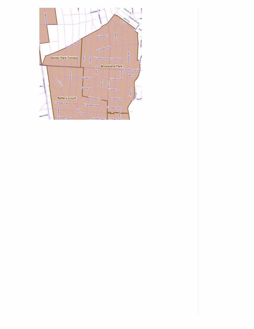
Neighborhoods in Richmond, Virginia
[top]
Credit and Sources
The text above is almost entirely sourced from the the registration form fromthe Brookland Park application to the National Register of Historic Places(PDF). The original document for the Brookland Park Historic District, datedMarch 2001, was put together by Kim Chen, Mary Sadler, Peter Witt, and JeanMcRae, and includes much more more than is shown here. Check out theoriginal form to learn more or read up on any of the other sites in Richmondthat are listed on the National Register.
All photos by John Murden unless otherwise noted. The circa 1990s photo of

9 C O M M E N T S
#1 • Elizabeth Lott • September 23, 2010 at 7:38 am
This is great! The old Barton Heights Baptist Church also fled the areawhen it sold to First African. That congregation is now NorthminsterChurch on Moss Side and Westwood. I’ve always wondered about BatteryPark Christian Church on Brook at Bellevue. Was it originally over here,too?
#2 • Phil Riggan • September 23, 2010 at 8:41 am
Fantastic work! John M you’ve outdone yourself again. I’ve driventhrough this area many times and wished that I could have seen the classand care the neighborhood had 80+ years ago. The economics of the areais preventing it from achieving a higher standard of living, but thearchitectural elements are all still in place. The area is served well by acould of parks too.
#3 • Kerry Riley • September 23, 2010 at 10:20 am
Great presentation. This is a wonderful way to get educated in thevarious architectural styles offered in Richmond in one relatively smallgeographic area. I plan on printing this out and taking a bicyle tour of thearea to see in person.
#4 • JB • September 23, 2010 at 12:09 pm
Intetesting. My husband’s grandfather was Mayor of Barton Heights inthe late 1800′s/early 1900′s, his family home still stands at Barton at Pie(though I believe the nursing home that occupied it most recently hasabandoned it), and his mother grew up on Montrose at Culpepper. Webought in Highland Park in part because of his family history, partlybecause of the gorgeous workmanship in our home (there’s a twin of it atAlbemarle/Lexington and Patterson), and the INCREDIBLE amount andquality of home we received for our money. We love our neighbors,mostly elderly, and are excited about the changes to the area such as themixed-income, mixed use, walkable neighborhood that will replace the
September 23, 2010 at 6:15 am By john m 9
9 people like this. Be the first of your friends.LikeLike
Posted in Etc Tagged Brookland Park, DHR
the Brookland Inn / 2900 block of North Avenue is from Virginia Film Office.The black&white photo of the trolley is from an unknown source.
Previous neighborhood profiles in the series:
The Town of Barton Heights
The Oakwood-Chimborazo Historic District
The Fairmount Historic District
The Church Hill North Historic District
The Highland Park Plaza Historic District
A history of the Chestnut Hill/Plateau Historic District
The Union Hill Historic District

deplorable housing projects on Dove; and the Cannon Creek Greenway,which will turn the ravine into part of the East Coast Greenway and willlink Barton Heights and Highland Park with walkable paths, bridges andparkland.
#5 • JB • September 23, 2010 at 12:12 pm
Whoops – Barton and POE. The perils of the iPhone keyboard and bigfingertips!
#6 • john m • September 23, 2010 at 12:14 pm
@Phil – I love putting these together, not sure which one to hit next.
#7 • AMK • November 23, 2010 at 3:36 pm
Wonderful history. I am Daniel W. Duling’s granddaughter and found thisis working on family tree. Frank Duling, the police chief in the 60″s, wasnot Dan’s son but rather his nephew. Just for the record.
#8 • Doug Riddell • July 8, 2013 at 10:26 am
Love this. I lived for many years at 403 Gladstone in a newer structurebuilt in 1955. Our claim to fame was the parachute landing of a pilotfrom the jet fighter plane which crashed in Windsor Farms in the late1950s or early 1960s (we moved to Henrico County in 1963). He landedin what was then an abandoned field bordered by Gladstone andBancroft, facing Alvis Avenue. I note that houses have since appeared inwhat used to be our impromptu playground.
My grandmother lived in the two-story stucco home located at 3126Edgewood. I always found it interesting that there was a small, circularmarker, about six inched in diameter, laid into the sidewalk between thehouse and the garage that identified the builder of the two-storystructure, whose name I can’t recall after all of these years. I thought it tobe an unusual feature, and wondered if, by chance, he was also the firstoccupant of the house.
The house across the street (3123 or 3121), I believe) was owned by alady who was a pattern cutter at Friedman-Marks, who just happened tobe the sister of Babe Ruth. The Babe came to Richmond and stayed at herhome on at least one occasion.
I attended JEB Stuart Elementary School and hold a special place in myheart for it. The auditorium was a full two-stories in height, and at onetime had a projection booth that could only be reached by a vertical metalladder. The cafeteria occupied the lower floor of the rounded portion ofthe building. My father also attended Stuart and had most of the sameteachers. A group of those of us who attended Stuart have oftenproposed visiting the school, but have not so far. We are told that thehigh ceilings have been lowered. I recall it being heated with a coal firedboiler.
From there, I attended Chandler [Northside] Junior High Schoolbetween 1961 and 1963. The front steps were wide and tall enough thatit was customary to pose the entire 8th grade (the school then housedthe 7th also) for a class picture. (It was necessary to halt traffic onBrookland Park Boulevard for the shot, because the photographer had tostand on the opposite side of the street to include everyone).
As for the intersection of North and “The Boulevard” (we seldom referred

Developed by PharrOut.Copyright 2014 North Richmond News and RVANews.We are in beta and ironing things out. Let us know if you have trouble.
0
JESSE THE CHIHUAHUAMIX IS MISSING
January 31, 2014
0
HARDYWOOD BOURBONSIDAMO RELEASE PARTYON SATURDAY
January 31, 2014
1
RICHMOND SCHOOLSCLOSED ON THURSDAY
January 29, 2014
R E C E N T P O S T S
MORE RECENT POSTS ›
R E C E N T C O M M E N T S
Mike LaBelle on What are theNorthside Civic Associations?
dr johnson on Highland Groveleasing first units
dr johnson on Highland Groveleasing first units
StElizabethCCVA on Richmondschools closed on Thursday
Richard on Clear your walks andcars
V I E WF L I C K R
to it by it’s proper name), it was the domain of my friend and fellowRichmond broadcaster, Harvey Hudson. Harv and a couple other JohnMarshall students from Barton Heights had sweaters with the letter “K”embroidered on the pocket–K standing for the “Korner” club. His friendand fellow north side resident, WLEE’S Lud Sterling (Sterling Ludgate),lived on Hanes Avenue, in the block north of Gladstone.
#9 • Sylvia • December 10, 2013 at 12:42 pm
Keep up the excellent work. It has a really excellent content on thissubject and your comments are quite accurate.