the chain forge hotel boston, massachusetts · h.w. moore associates inc. march 7, 2018 ... inland...
TRANSCRIPT

Notice of Intent Application
Submitted by:CVPA Chain Forge, LLC451 D Street – Suite 100Boston, MA 02210
Submitted to:Boston Conservation CommissionCity of Boston Environment Department Boston City Hall, Room 805 Boston, MA 02201
Prepared by:Epsilon Associates, Inc.3 Mill & Main Place, Suite 250Maynard, MA 01754
In Association with:Bargmann Hendrie + Archetype, Inc.H.W. Moore Associates Inc.
March 7, 2018
Massachusetts Wetlands Protection Act (M.G.L. c.131 s.40)
The Chain Forge HotelBoston, Massachusetts

Notice of Intent Application
Massachusetts Wetlands Protection Act (M.G.L. c.131 s.40)
Chain Forge Hotel
Charlestown Navy Yard 105 First Avenue
Submitted by: CVPA Chain Forge, LLC
451 D Street – Suite 100
Boston, MA 02210
Prepared by:
Epsilon Associates, Inc.
3 Mill & Main Place, Suite 250
Maynard, Massachusetts 01754
In Association with:
Bargmann Hendrie + Archetype, Inc.
H.W. Moore Associates Inc.
March 7, 2018

5090/Chain Forge/NOI i Table of Contents Epsilon Associates, Inc.
TABLE OF CONTENTS
WPA FORM 3
BOSTON CONSERVATION COMMISSION FILING CHECKLIST
ATTACHMENT A – PROJECT NARRATIVE 1 1.0 Introduction 1 2.0 Existing Conditions 1
2.1 Land Subject to Coastal Storm Flowage 1 2.2 Natural Heritage and Endangered Species Program Atlas 2
3.0 Proposed Project 2 3.1 Proposed Stormwater Management 2
4.0 Environmental Mitigation, Compliance and Monitoring 3 4.1 Sedimentation and Erosion Controls 3 4.2 Dewatering Protocols 4 4.3 Spill Prevention and Response Plan 4
5.0 Conclusions 5
List of Attachments
Attachment A – Project Narrative Attachment B – Figures Figure 1. USGS Locus Map Figure 2. Aerial Locus Map Figure 3. Coastal Resources Map Figure 4. FEMA Map Figure 5. NHESP Map Attachment C – Site Photographs Attachment D -- Filing Fee Information Attachment E – Abutter Notification Attachment F – Site Plans/Stormwater Checklist
Conservation Commission Submittal Checklist
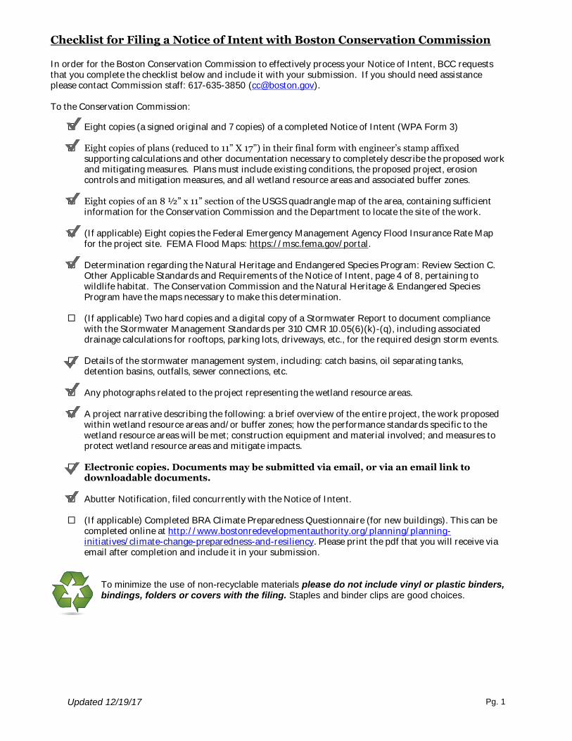
Checklist for Filing a Notice of Intent with Boston Conservation Commission
Updated 12/19/17 Pg. 1
In order for the Boston Conservation Commission to effectively process your Notice of Intent, BCC requests that you complete the checklist below and include it with your submission. If you should need assistance please contact Commission staff: 617-635-3850 ([email protected]). To the Conservation Commission:
Eight copies (a signed original and 7 copies) of a completed Notice of Intent (WPA Form 3)
Eight copies of plans (reduced to 11” X 17”) in their final form with engineer’s stamp affixed supporting calculations and other documentation necessary to completely describe the proposed work and mitigating measures. Plans must include existing conditions, the proposed project, erosion controls and mitigation measures, and all wetland resource areas and associated buffer zones.
Eight copies of an 8 ½” x 11” section of the USGS quadrangle map of the area, containing sufficient
information for the Conservation Commission and the Department to locate the site of the work.
(If applicable) Eight copies the Federal Emergency Management Agency Flood Insurance Rate Map for the project site. FEMA Flood Maps: https://msc.fema.gov/portal.
Determination regarding the Natural Heritage and Endangered Species Program: Review Section C.
Other Applicable Standards and Requirements of the Notice of Intent, page 4 of 8, pertaining to wildlife habitat. The Conservation Commission and the Natural Heritage & Endangered Species Program have the maps necessary to make this determination.
(If applicable) Two hard copies and a digital copy of a Stormwater Report to document compliance
with the Stormwater Management Standards per 310 CMR 10.05(6)(k)-(q), including associated drainage calculations for rooftops, parking lots, driveways, etc., for the required design storm events.
Details of the stormwater management system, including: catch basins, oil separating tanks,
detention basins, outfalls, sewer connections, etc. Any photographs related to the project representing the wetland resource areas. A project narrative describing the following: a brief overview of the entire project, the work proposed
within wetland resource areas and/or buffer zones; how the performance standards specific to the wetland resource areas will be met; construction equipment and material involved; and measures to protect wetland resource areas and mitigate impacts.
Electronic copies. Documents may be submitted via email, or via an email link to
downloadable documents. Abutter Notification, filed concurrently with the Notice of Intent.
(If applicable) Completed BRA Climate Preparedness Questionnaire (for new buildings). This can be
completed online at http://www.bostonredevelopmentauthority.org/planning/planning-initiatives/climate-change-preparedness-and-resiliency. Please print the pdf that you will receive via email after completion and include it in your submission.
To minimize the use of non-recyclable materials please do not include vinyl or plastic binders, bindings, folders or covers with the filing. Staples and binder clips are good choices.

WPA Form 3 – Notice of Intent
wpaform3.doc • rev. 3/10/2016
Page 2 of 9
Massachusetts Department of Environmental Protection Bureau of Resource Protection - Wetlands
WPA Form 3 – Notice of Intent Massachusetts Wetlands Protection Act M.G.L. c. 131, §40
Provided by MassDEP:
MassDEP File Number Document Transaction Number Boston City/Town
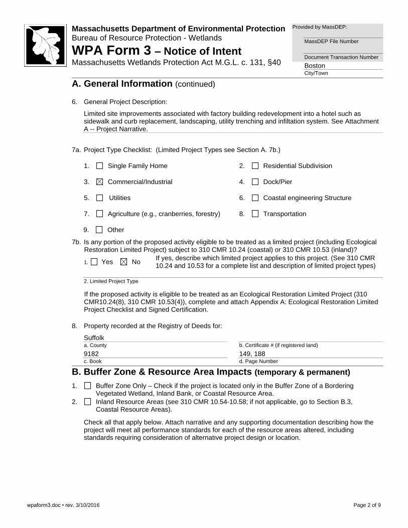
A. General Information (continued) 6. General Project Description:
Limited site improvements associated with factory building redevelopment into a hotel such as sidewalk and curb replacement, landscaping, utility trenching and infiltation system. See Attachment A -- Project Narrative.
7a. Project Type Checklist: (Limited Project Types see Section A. 7b.)
1. Single Family Home 2. Residential Subdivision
3. Commercial/Industrial 4. Dock/Pier
5. Utilities 6. Coastal engineering Structure
7. Agriculture (e.g., cranberries, forestry) 8. Transportation
9. Other
7b. Is any portion of the proposed activity eligible to be treated as a limited project (including Ecological Restoration Limited Project) subject to 310 CMR 10.24 (coastal) or 310 CMR 10.53 (inland)?
1. Yes No If yes, describe which limited project applies to this project. (See 310 CMR 10.24 and 10.53 for a complete list and description of limited project types)
2. Limited Project Type
If the proposed activity is eligible to be treated as an Ecological Restoration Limited Project (310 CMR10.24(8), 310 CMR 10.53(4)), complete and attach Appendix A: Ecological Restoration Limited Project Checklist and Signed Certification.
8. Property recorded at the Registry of Deeds for:
Suffolk a. County
b. Certificate # (if registered land)
9182 c. Book
149, 188 d. Page Number
B. Buffer Zone & Resource Area Impacts (temporary & permanent)
1. Buffer Zone Only – Check if the project is located only in the Buffer Zone of a Bordering Vegetated Wetland, Inland Bank, or Coastal Resource Area.
2. Inland Resource Areas (see 310 CMR 10.54-10.58; if not applicable, go to Section B.3, Coastal Resource Areas).
Check all that apply below. Attach narrative and any supporting documentation describing how the project will meet all performance standards for each of the resource areas altered, including standards requiring consideration of alternative project design or location.
wpaform3.doc • rev. 3/10/2016
Page 3 of 9
Massachusetts Department of Environmental Protection Bureau of Resource Protection - Wetlands
WPA Form 3 – Notice of Intent Massachusetts Wetlands Protection Act M.G.L. c. 131, §40
Provided by MassDEP:
MassDEP File Number Document Transaction Number Boston City/Town
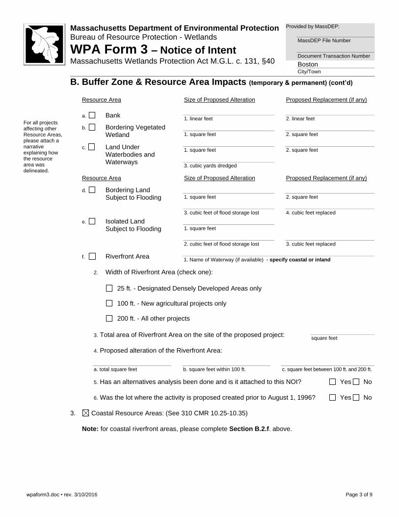
B. Buffer Zone & Resource Area Impacts (temporary & permanent) (cont’d)
For all projects affecting other Resource Areas, please attach a narrative explaining how the resource area was delineated.
Resource Area Size of Proposed Alteration Proposed Replacement (if any)
a. Bank 1. linear feet
2. linear feet
b. Bordering Vegetated Wetland
1. square feet
2. square feet
c. Land Under Waterbodies and Waterways
1. square feet
2. square feet
3. cubic yards dredged
Resource Area Size of Proposed Alteration Proposed Replacement (if any)
d. Bordering Land Subject to Flooding
1. square feet
2. square feet
3. cubic feet of flood storage lost
4. cubic feet replaced
e. Isolated Land Subject to Flooding
1. square feet
2. cubic feet of flood storage lost
3. cubic feet replaced
f. Riverfront Area 1. Name of Waterway (if available) - specify coastal or inland
2. Width of Riverfront Area (check one):
25 ft. - Designated Densely Developed Areas only
100 ft. - New agricultural projects only
200 ft. - All other projects
3. Total area of Riverfront Area on the site of the proposed project: square feet
4. Proposed alteration of the Riverfront Area:
a. total square feet
b. square feet within 100 ft.
c. square feet between 100 ft. and 200 ft.
5. Has an alternatives analysis been done and is it attached to this NOI? Yes No
6. Was the lot where the activity is proposed created prior to August 1, 1996? Yes No
3. Coastal Resource Areas: (See 310 CMR 10.25-10.35)
Note: for coastal riverfront areas, please complete Section B.2.f. above.

wpaform3.doc • rev. 3/10/2016
Page 4 of 9
Massachusetts Department of Environmental Protection Bureau of Resource Protection - Wetlands
WPA Form 3 – Notice of Intent Massachusetts Wetlands Protection Act M.G.L. c. 131, §40
Provided by MassDEP:
MassDEP File Number Document Transaction Number Boston City/Town
B. Buffer Zone & Resource Area Impacts (temporary & permanent) (cont’d)
Check all that apply below. Attach narrative and supporting documentation describing how the project will meet all performance standards for each of the resource areas altered, including standards requiring consideration of alternative project design or location.
Online Users: Include your document transaction number (provided on your receipt page) with all supplementary information you submit to the Department.
Resource Area Size of Proposed Alteration Proposed Replacement (if any)
a. Designated Port Areas Indicate size under Land Under the Ocean, below
b. Land Under the Ocean 1. square feet
2. cubic yards dredged
c. Barrier Beach Indicate size under Coastal Beaches and/or Coastal Dunes below
d. Coastal Beaches 1. square feet
2. cubic yards beach nourishment
e. Coastal Dunes
1. square feet 2. cubic yards dune nourishment
Size of Proposed Alteration Proposed Replacement (if any)
f. Coastal Banks
1. linear feet g. Rocky Intertidal
Shores 1. square feet
h. Salt Marshes
1. square feet 2. sq ft restoration, rehab., creation
i. Land Under Salt Ponds
1. square feet
2. cubic yards dredged
j. Land Containing Shellfish
1. square feet
k. Fish Runs Indicate size under Coastal Banks, inland Bank, Land Under the Ocean, and/or inland Land Under Waterbodies and Waterways, above
1. cubic yards dredged
l. Land Subject to Coastal Storm Flowage
40,100 1. square feet
4. Restoration/Enhancement If the project is for the purpose of restoring or enhancing a wetland resource area in addition to the square footage that has been entered in Section B.2.b or B.3.h above, please enter the additional amount here.
a. square feet of BVW
b. square feet of Salt Marsh
5. Project Involves Stream Crossings
a. number of new stream crossings
b. number of replacement stream crossings
wpaform3.doc • rev. 3/10/2016
Page 5 of 9
Massachusetts Department of Environmental Protection Bureau of Resource Protection - Wetlands
WPA Form 3 – Notice of Intent Massachusetts Wetlands Protection Act M.G.L. c. 131, §40
Provided by MassDEP:
MassDEP File Number Document Transaction Number Boston City/Town
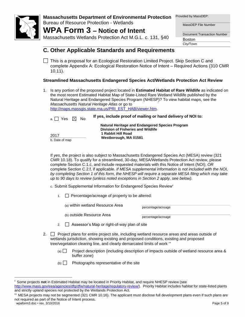
C. Other Applicable Standards and Requirements
This is a proposal for an Ecological Restoration Limited Project. Skip Section C and complete Appendix A: Ecological Restoration Notice of Intent – Required Actions (310 CMR 10.11).
Streamlined Massachusetts Endangered Species Act/Wetlands Protection Act Review
1. Is any portion of the proposed project located in Estimated Habitat of Rare Wildlife as indicated on
the most recent Estimated Habitat Map of State-Listed Rare Wetland Wildlife published by the Natural Heritage and Endangered Species Program (NHESP)? To view habitat maps, see the Massachusetts Natural Heritage Atlas or go to http://maps.massgis.state.ma.us/PRI_EST_HAB/viewer.htm.
a. Yes No If yes, include proof of mailing or hand delivery of NOI to:
Natural Heritage and Endangered Species Program Division of Fisheries and Wildlife 1 Rabbit Hill Road Westborough, MA 01581
Phone: (508) 389-6360
2017 b. Date of map
If yes, the project is also subject to Massachusetts Endangered Species Act (MESA) review (321 CMR 10.18). To qualify for a streamlined, 30-day, MESA/Wetlands Protection Act review, please complete Section C.1.c, and include requested materials with this Notice of Intent (NOI); OR complete Section C.2.f, if applicable. If MESA supplemental information is not included with the NOI, by completing Section 1 of this form, the NHESP will require a separate MESA filing which may take up to 90 days to review (unless noted exceptions in Section 2 apply, see below).
c. Submit Supplemental Information for Endangered Species Review
1. Percentage/acreage of property to be altered:
(a) within wetland Resource Area percentage/acreage
(b) outside Resource Area percentage/acreage
2. Assessor’s Map or right-of-way plan of site
2. Project plans for entire project site, including wetland resource areas and areas outside of wetlands jurisdiction, showing existing and proposed conditions, existing and proposed tree/vegetation clearing line, and clearly demarcated limits of work
(a) Project description (including description of impacts outside of wetland resource area & buffer zone)
(b) Photographs representative of the site
Some projects not in Estimated Habitat may be located in Priority Habitat, and require NHESP review (see http://www.mass.gov/eea/agencies/dfg/dfw/natural-heritage/regulatory-review/). Priority Habitat includes habitat for state-listed plants and strictly upland species not protected by the Wetlands Protection Act. MESA projects may not be segmented (321 CMR 10.16). The applicant must disclose full development plans even if such plans are not required as part of the Notice of Intent process.
wpaform3.doc • rev. 3/10/2016
Page 6 of 9
Massachusetts Department of Environmental Protection Bureau of Resource Protection - Wetlands
WPA Form 3 – Notice of Intent Massachusetts Wetlands Protection Act M.G.L. c. 131, §40
Provided by MassDEP:
MassDEP File Number Document Transaction Number Boston City/Town
C. Other Applicable Standards and Requirements (cont’d)
(c) MESA filing fee (fee information available at http://www.mass.gov/dfwele/dfw/nhesp/regulatory_review/mesa/mesa_fee_schedule.htm). Make check payable to “Commonwealth of Massachusetts - NHESP” and mail to NHESP at above address
Projects altering 10 or more acres of land, also submit:
(d) Vegetation cover type map of site
(e) Project plans showing Priority & Estimated Habitat boundaries
(f) OR Check One of the Following
1. Project is exempt from MESA review.
Attach applicant letter indicating which MESA exemption applies. (See 321 CMR 10.14, http://www.mass.gov/dfwele/dfw/nhesp/regulatory_review/mesa/mesa_exemptions.htm; the NOI must still be sent to NHESP if the project is within estimated habitat pursuant to 310 CMR 10.37 and 10.59.)
2. Separate MESA review ongoing.
a. NHESP Tracking # b. Date submitted to NHESP
3. Separate MESA review completed.
Include copy of NHESP “no Take” determination or valid Conservation & Management Permit with approved plan.
3. For coastal projects only, is any portion of the proposed project located below the mean high water line or in a fish run?
a. Not applicable – project is in inland resource area only b. Yes No
If yes, include proof of mailing, hand delivery, or electronic delivery of NOI to either:
South Shore - Cohasset to Rhode Island border, and the Cape & Islands:
Division of Marine Fisheries - Southeast Marine Fisheries Station Attn: Environmental Reviewer 1213 Purchase Street – 3rd Floor New Bedford, MA 02740-6694 Email: [email protected]
North Shore - Hull to New Hampshire border:
Division of Marine Fisheries - North Shore Office
Attn: Environmental Reviewer 30 Emerson Avenue
Gloucester, MA 01930 Email: [email protected]
Also if yes, the project may require a Chapter 91 license. For coastal towns in the Northeast Region, please contact MassDEP’s Boston Office. For coastal towns in the Southeast Region, please contact MassDEP’s Southeast Regional Office.
wpaform3.doc • rev. 3/10/2016
Page 7 of 9
Massachusetts Department of Environmental Protection Bureau of Resource Protection - Wetlands
WPA Form 3 – Notice of Intent Massachusetts Wetlands Protection Act M.G.L. c. 131, §40
Provided by MassDEP:
MassDEP File Number Document Transaction Number Boston City/Town
C. Other Applicable Standards and Requirements (cont’d)
Online Users: Include your document transaction number (provided on your receipt page) with all supplementary information you submit to the Department.
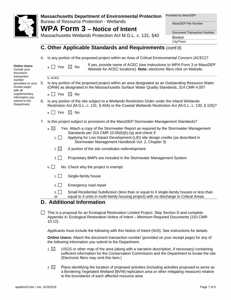
4. Is any portion of the proposed project within an Area of Critical Environmental Concern (ACEC)?
a. Yes No If yes, provide name of ACEC (see instructions to WPA Form 3 or MassDEP Website for ACEC locations). Note: electronic filers click on Website.
b. ACEC
5. Is any portion of the proposed project within an area designated as an Outstanding Resource Water (ORW) as designated in the Massachusetts Surface Water Quality Standards, 314 CMR 4.00?
a. Yes No
6. Is any portion of the site subject to a Wetlands Restriction Order under the Inland Wetlands Restriction Act (M.G.L. c. 131, § 40A) or the Coastal Wetlands Restriction Act (M.G.L. c. 130, § 105)?
a. Yes No
7. Is this project subject to provisions of the MassDEP Stormwater Management Standards?
a. Yes. Attach a copy of the Stormwater Report as required by the Stormwater Management Standards per 310 CMR 10.05(6)(k)-(q) and check if:
1. Applying for Low Impact Development (LID) site design credits (as described in Stormwater Management Handbook Vol. 2, Chapter 3)
2. A portion of the site constitutes redevelopment
3. Proprietary BMPs are included in the Stormwater Management System.
b. No. Check why the project is exempt:
1. Single-family house
2. Emergency road repair
3. Small Residential Subdivision (less than or equal to 4 single-family houses or less than or equal to 4 units in multi-family housing project) with no discharge to Critical Areas.
D. Additional Information
This is a proposal for an Ecological Restoration Limited Project. Skip Section D and complete Appendix A: Ecological Restoration Notice of Intent – Minimum Required Documents (310 CMR 10.12).
Applicants must include the following with this Notice of Intent (NOI). See instructions for details.
Online Users: Attach the document transaction number (provided on your receipt page) for any of the following information you submit to the Department.
1. USGS or other map of the area (along with a narrative description, if necessary) containing sufficient information for the Conservation Commission and the Department to locate the site. (Electronic filers may omit this item.)
2. Plans identifying the location of proposed activities (including activities proposed to serve as a Bordering Vegetated Wetland [BVW] replication area or other mitigating measure) relative to the boundaries of each affected resource area.
wpaform3.doc • rev. 3/10/2016
Page 8 of 9
Massachusetts Department of Environmental Protection Bureau of Resource Protection - Wetlands
WPA Form 3 – Notice of Intent Massachusetts Wetlands Protection Act M.G.L. c. 131, §40
Provided by MassDEP:
MassDEP File Number Document Transaction Number Boston City/Town
D. Additional Information (cont’d)
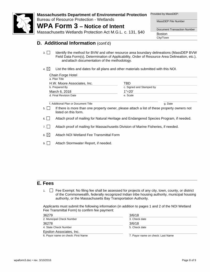
3. Identify the method for BVW and other resource area boundary delineations (MassDEP BVW Field Data Form(s), Determination of Applicability, Order of Resource Area Delineation, etc.), and attach documentation of the methodology.
4. List the titles and dates for all plans and other materials submitted with this NOI.
Chain Forge Hotel a. Plan Title
H.W. Moore Associates, Inc. b. Prepared By
TBD c. Signed and Stamped by
March 6, 2018 d. Final Revision Date
1"=20' e. Scale
f. Additional Plan or Document Title
g. Date
5. If there is more than one property owner, please attach a list of these property owners not listed on this form.
6. Attach proof of mailing for Natural Heritage and Endangered Species Program, if needed.
7. Attach proof of mailing for Massachusetts Division of Marine Fisheries, if needed.
8. Attach NOI Wetland Fee Transmittal Form
9. Attach Stormwater Report, if needed.
E. Fees
1. Fee Exempt: No filing fee shall be assessed for projects of any city, town, county, or district of the Commonwealth, federally recognized Indian tribe housing authority, municipal housing authority, or the Massachusetts Bay Transportation Authority.
Applicants must submit the following information (in addition to pages 1 and 2 of the NOI Wetland Fee Transmittal Form) to confirm fee payment:
36279 2. Municipal Check Number
3/6/18 3. Check date
36278 4. State Check Number
3/6/18 5. Check date
Epsilon Associates, Inc. 6. Payor name on check: First Name
7. Payor name on check: Last Name

3/6/18

Attachment A
Project Narrative
5090/Chain Forge/NOI 1 Attachment A Epsilon Associates, Inc.
ATTACHMENT A – PROJECT NARRATIVE
1.0 Introduction
On behalf of CVPA Chain Forge LLC (“Applicant”), Epsilon Associates, Inc. (“Epsilon”) is pleased to submit this Notice of Intent (NOI) to the Boston Conservation Commission (the “Commission”). This NOI has been prepared in accordance with the Massachusetts Wetlands Protection Act (MGL c. 131 §40 (the “Act”) and implementing Regulations (310 CMR 10.00) (the “Regulations”).
The work described herein involves redevelopment activities at the historic Chain Forge Building located at 105 First Avenue in Charlestown, Massachusetts (the “Project”). The Applicant proposes to redevelop the former factory building into a 230-room hotel. A portion of the proposed redevelopment activities involves work within the 100-year floodplain (Land Subject to Coastal Storm Flowage) under the Massachusetts Wetlands Protection Act Regulations (310 CMR 10.00). This NOI has been prepared and submitted in accordance with these regulations, and requests approval to construct the Project within locations subject to the jurisdiction of the Boston Conservation Commission.
2.0 Existing Conditions
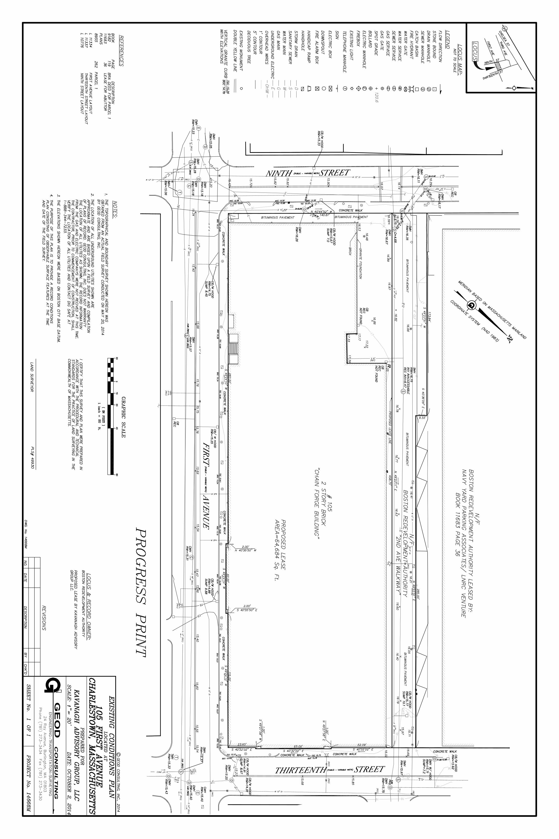
The Project Site is comprised of an approximately 1.5-acre parcel of land located at 105 First Avenue within the Charlestown Navy Yard. The site is bounded by Ninth Street to the south, Thirteenth Street to the north, Second Avenue pedestrian walkway to the west and First Avenue to the east (see Figure 1– USGS Locus Map and Figure 2 - Aerial Locus Map in Attachment B). The existing Chain Forge Factory building is essentially three connected buildings totally 63,000 gross square feet. The brick-façade factory building was originally built in 1904 and has been vacant since the 1974 closure of the Boston Naval Shipyward and was conveyed to the Boston Redevelopment Authority in 1978. The site is entirely comprised of either building or paved areas.
The Site is located approximately 600 feet from Boston Harbor. Wetland resource areas on or proximate to the Project site are limited to Land Subject to Coastal Storm Flowage (elevation 10-feet NAVD 88 datum). No other resource areas are present (see Figure 3 – Coastal Resources Map in Attachment B and in Attachment F – Plan Drawings).
See below for additional information and also Attachment C for photos of existing site conditions.
2.1 Land Subject to Coastal Storm Flowage
Land Subject to Coastal Storm Flowage (LSCSF) is defined at 310 CMR 10.04 as land subject to any inundation caused by coastal storms up to and including that caused by the 100-year storm, surge of record or storm of record, whichever is greater. According to the updated Federal Emergency Management Agency Flood Insurance Rate Map
5090/Chain Forge/NOI 2 Attachment A Epsilon Associates, Inc.
(“FEMA-FIRM”), Community-Panel Numbers 25025C0018J and 25025C0081J, Effective Date March 16, 2016, there is a small area of the site designated as “Zone AE Area of 100-Year Flood” (Elevation 10 feet NAVD 88, 16.46 feet Boston City Base) within the southeast corner of the Project Site. An updated site survey indicates that the majority of the surrounding streets and sidewalks do fall within Zone AE. See Figure 4 in Attachment B and Attachment F for more information.
2.2 Natural Heritage and Endangered Species Program Atlas
No portion of the Project Site is located within areas mapped as Priority Habitat of Rare Species and Estimated Habitat of Rare Wildlife by the Natural Heritage and Endangered Species Program under the Massachusetts Endangered Species Act and the Massachusetts Wetlands Protection Act, respectively (Natural Heritage MassGIS, 2017). There are no mapped Potential Vernal Pools or Certified Vernal Pools within or proximate to the Project Site (See Figure 5 – NHESP Map in Attachment B).
3.0 Proposed Project
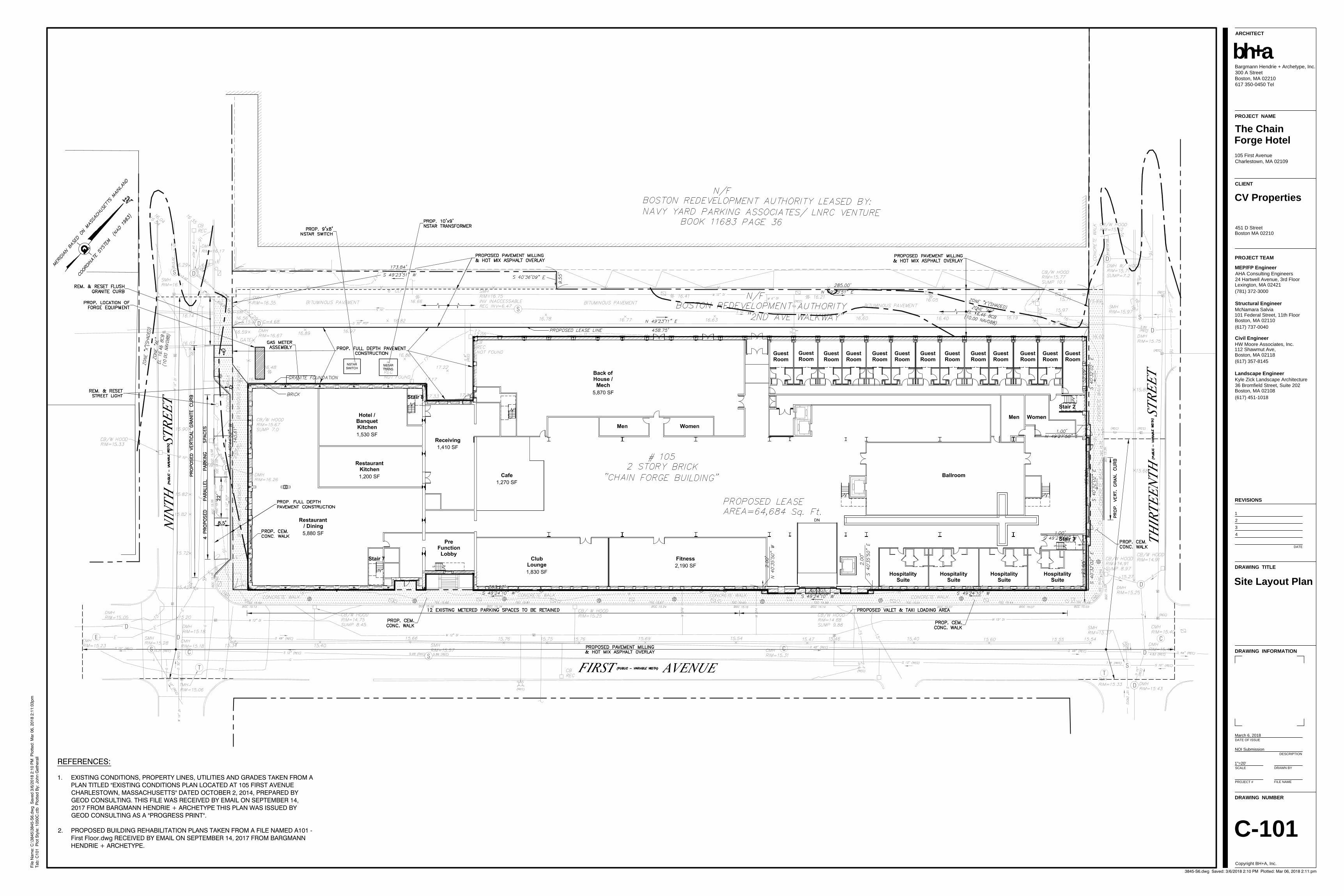
This Project proposes the redevelopment of the former Chain Forge factory building into a 230-room hotel. The hotel entrance will be along First Avenue with a rear service area and access along Second Avenue. The ground floor of the hotel will be raised 18-inches over existing conditions, resulting in a ground floor that is above the flood zone at Elevation 10 feet NAVD 88 or 16.46 feet BCB. While the majority of the proposed Project involves interior building construction and modifications, some exterior work will also be completed along the façade and surrounding paved areas. This includes sidewalk and curb replacement, site utility work, re-pointing of the building façade, landscaping, re-paving and installation of new windows. There will be no increase in impervious surface at the Project site.
Site utility work consists of trenches for sewer line connections and new manholes. The proposed subsurface stormwater management infiltration system will also be installed proximate to the rear service entrance along the Second Avenue walkway. Also proximate to the rear service entrance, a new switch and transformer will be installed on concrete pads elevated out of the flood zone at elevation 17.5 feet Boston City Base).
3.1 Proposed Stormwater Management
The proposed stormwater management system will designed to comply with Boston Water and Sewer Commission (“BWSC”) requirements and the MassDEP stormwater management standards that were incorporated into the Wetlands Protection Act Regulations on January 2, 2008 [see 310 CMR 10.05(6)(k)]. Since the existing site already consists entirely of impervious cover, the proposed Project will not create additional impervious surface areas. However, the Project will reduce the amount of runoff from the site by 2,840 cubic feet during storm events.
5090/Chain Forge/NOI 3 Attachment A Epsilon Associates, Inc.
Stormwater from the site, including roof drainage, currently discharges to the existing systems in the adjacent streets: a 12-inch drain in Ninth Street, a 36-inch drain in Second Avenue, and a 48-inch drain in First Avenue. These drains flow easterly toward Thirteenth Street and ultimately to Boston Harbor.
A portion of the rooftop runoff will be directed to a subsurface infiltration system installed at the rear of the building. This system will accommodate up to 2,840 cubic feet of volume and redirect it from entering Boston’s stormwater management drain system. Any overflow will be directed to the municipal drain system. The post-redevelopment conditions will result in a reduction of site runoff. Please see Attachment F for the Site Plans and Stormwater Checklist.
4.0 Environmental Mitigation, Compliance and Monitoring
Ground disturbing activities are primarily limited to trenchwork, landscaping and the installation of the subsurface stormwater infiltration system. An erosion and sediment control program will minimize the risk of impacts to wetland resource areas associated with the Boston Harbor during construction of the Project. The program will incorporate BMPs specified in the guidelines developed by the MassDEP and the U.S. Environmental Protection Agency (“EPA”). The Stormwater Pollution Prevention Plan (“SWPPP”) will be finalized prior to construction.
The site contractor will be responsible for inspecting the sediment and erosion controls on a regular basis to note any escape of sediments. Inspections will cover disturbed areas of the construction site that have not been finally stabilized, areas used for storage of materials that are exposed to precipitation, structural control measures, and locations where vehicles enter or exit the site.
4.1 Sedimentation and Erosion Controls
Erosion and sediment control measures proposed for site preparation and development phases will include the following components:
Catch Basin Inlet Protection
During construction, drain inlets along First Avenue, Second Avenue, Thirteenth Street and Ninth Street will be protected from sediment inflow through the installation of “silt sacks”. The catch basins will be inspected after each rainfall with any significant accumulations of silt or sediment being removed and properly disposed.
Sediment Track-Out
The adjacent roadways surrounding the project site will be swept regularly of sediment tracked onto roadways to reduce potential total suspended solids (“TSS”) loading generated by construction vehicles traveling to and from the project site.
5090/Chain Forge/NOI 4 Attachment A Epsilon Associates, Inc.
Soil Management
Prior to construction, the contractor shall identify locations for soil stockpiles on-site for approval by the responsible engineer. Stockpiles that will be left for more than 14 days shall be protected by a perimeter of erosion controls (e.g. straw wattles) at the down gradient end and also will be covered by a plastic covering, temporary seeding, or equivalent BMP. Other areas of exposed soil will also be mulched or seeded within 7 days of grading if area will not be actively worked for greater than 14 days.
Dust Control
Dust control will be implemented as needed and during windy conditions (forecasted or actual wind conditions of 20 mph or greater) while excavation work is occurring.
Siltation Barriers
Siltation barriers composed of staked straw wattles may be necessary during trench work and infiltration system installation. All barriers will remain in place until disturbed areas are stabilized. An adequate stockpile of erosion control materials will be onsite at all times for emergency or routine replacement.
4.2 Dewatering Protocols
Although not anticipated due to depth of construction activities, should the need for de-watering arise during construction of the Project, groundwater will be pumped directly from the work area into portable fractionation tanks prior to discharge into the catch basin system. All discharges shall be free from visible floating, suspended and settleable solids that would impair the functions of a wetland resource area or degrade the chemical composition of the wetland resource area and the Boston Harbor receiving said water.
4.3 Spill Prevention and Response Plan
During construction, the contractor will follow these procedures to prevent and manage spills, if necessary:
♦ Manufacturer’s recommended methods for spill cleanup will be clearly posted and site personnel will be made aware of the procedures and the location of the information and cleanup supplies.
♦ The Contractor shall provide a 55 gallon spill containment kit and maintain it onsite throughout the construction period.
♦ All spills will be cleaned up immediately after discovery.
♦ The spill area will be kept well ventilated and personnel will wear appropriate protective clothing to prevent injury from contact with a hazardous substance.

5090/Chain Forge/NOI 5 Attachment A Epsilon Associates, Inc.
♦ Spills of toxic or hazardous materials, at or greater than reportable quantities, will be reported to the appropriate state or local government agency.
♦ The spill prevention plan will be adjusted to include measures to prevent this type of spill from reoccurring and how to clean up the spill if there is another one. A description of the spill, what caused it, and the cleanup measures will also be included.
♦ The Site Superintendent is the designated responsible party for day to day operations and spill clean-up procedures.
5.0 Conclusions
The information contained in this NOI describes the wetland resource areas located in the project area, the proposed construction activities and the effect of said work on the resource areas, and demonstrates that the work can be completed in accordance with the applicable performance standards for the affected resource areas. The Applicant therefore respectfully requests that the Boston Conservation Commission issue an Order of Conditions approving the project with appropriate conditions to protect the interests identified in M.G.L. c. 131 §40.

Attachment B
Figures

USGS, MassGIS
Figure 1USGS Locus Map
Chain Forge - 105 First Avenue Boston, Massachusetts
G:\Projects2\MA\Boston\5090\MXD\usgs.mxd Data Source: Office of Geographic Information (MassGIS), Commonwealth of Massachusetts, Information Technology Division
Project Site
°0 1,000 2,000500Feet1 inch = 2,000 feet
Scale 1:24,000
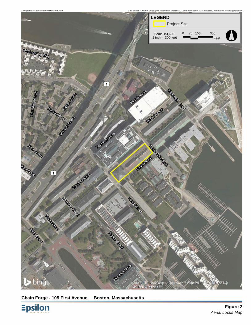
Figure 2Aerial Locus Map
Chain Forge - 105 First Avenue Boston, Massachusetts
G:\Projects2\MA\Boston\5090\MXD\aerial.mxd Data Source: Office of Geographic Information (MassGIS), Commonwealth of Massachusetts, Information Technology Division
LEGENDProject Site
°0 150 30075Feet1 inch = 300 feet
Scale 1:3,600

Figure 3Coastal Resources Map
Chain Forge - 105 First Avenue Boston, Massachusetts
G:\Projects2\MA\Boston\5090\MXD\coastal.mxd Data Source: Office of Geographic Information (MassGIS), Commonwealth of Massachusetts, Information Technology Division
LEGENDProject Site
MassDEP Wetlands (2005)Coastal Bank Bluff
Rocky Intertidal Shore
Tidal Flat
Open Water
°0 150 30075Feet1 inch = 300 feet
Scale 1:3,600
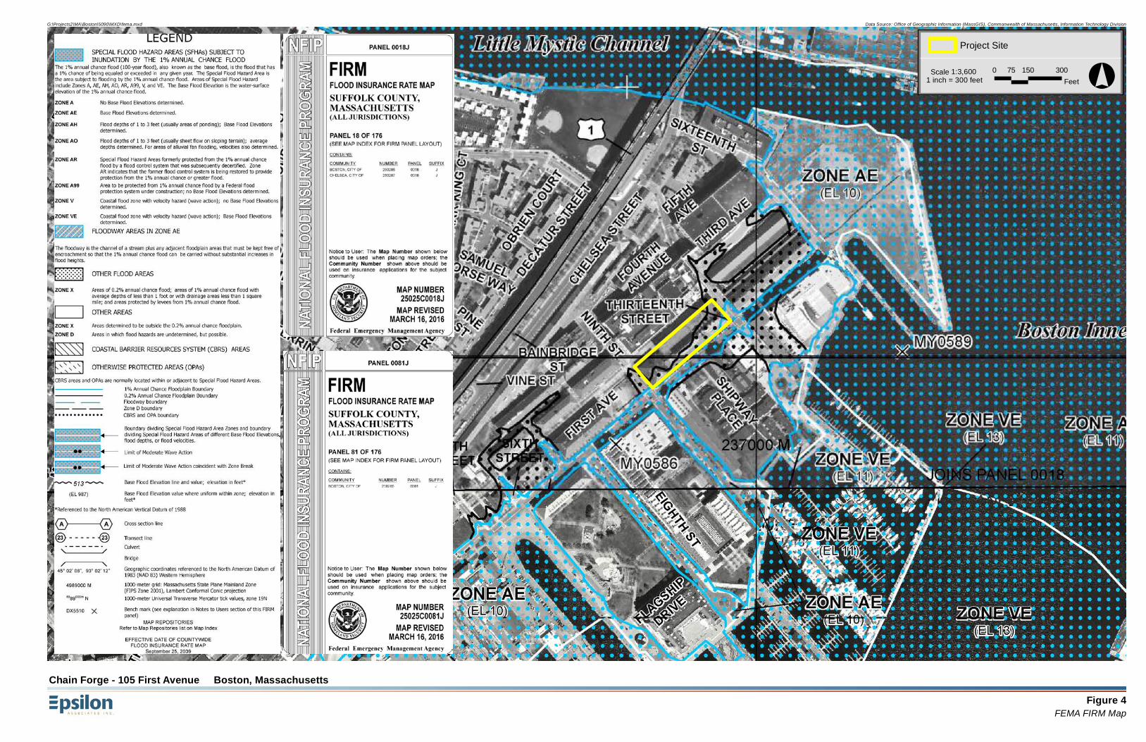
Figure 4FEMA FIRM Map
Chain Forge - 105 First Avenue Boston, Massachusetts
G:\Projects2\MA\Boston\5090\MXD\fema.mxd Data Source: Office of Geographic Information (MassGIS), Commonwealth of Massachusetts, Information Technology Division
Project Site
°0 150 30075Feet1 inch = 300 feet
Scale 1:3,600
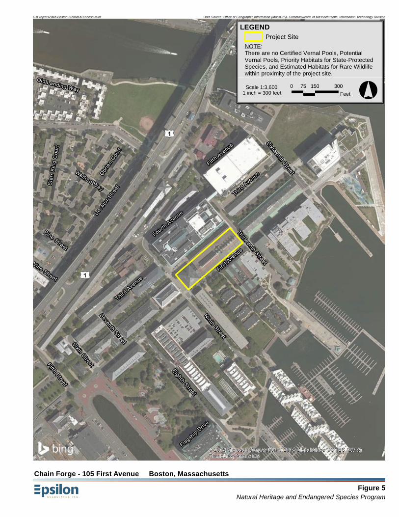
Figure 5Natural Heritage and Endangered Species Program
Chain Forge - 105 First Avenue Boston, Massachusetts
G:\Projects2\MA\Boston\5090\MXD\nhesp.mxd Data Source: Office of Geographic Information (MassGIS), Commonwealth of Massachusetts, Information Technology Division
LEGENDProject Site
°0 150 30075Feet1 inch = 300 feet
Scale 1:3,600
NOTE:There are no Certified Vernal Pools, PotentialVernal Pools, Priority Habitats for State-ProtectedSpecies, and Estimated Habitats for Rare Wildlifewithin proximity of the project site.

Attachment C
Site Photographs

Site Photos
105 First Avenue, Boston, MA
Photo 2: View facing north west from 1st Avenue.
Photo 1: View facing west from the intersection of 1st Avenue and 13th
Street.

Site Photos
105 First Avenue, Boston, MA
Photo 3: View facing north from the intersection of 1st Avenue and 9th
Street.
Photo 4: View facing northeast from 1st Avenue.

Attachment D
Filing Fee Information
noifeetf.doc • Wetland Fee Transmittal Form • rev. 10/11 Page 1 of 2
Massachusetts Department of Environmental Protection Bureau of Resource Protection - Wetlands NOI Wetland Fee Transmittal Form Massachusetts Wetlands Protection Act M.G.L. c. 131, §40
Important: When filling out forms on the computer, use only the tab key to move your cursor - do not use the return key.
A. Applicant Information
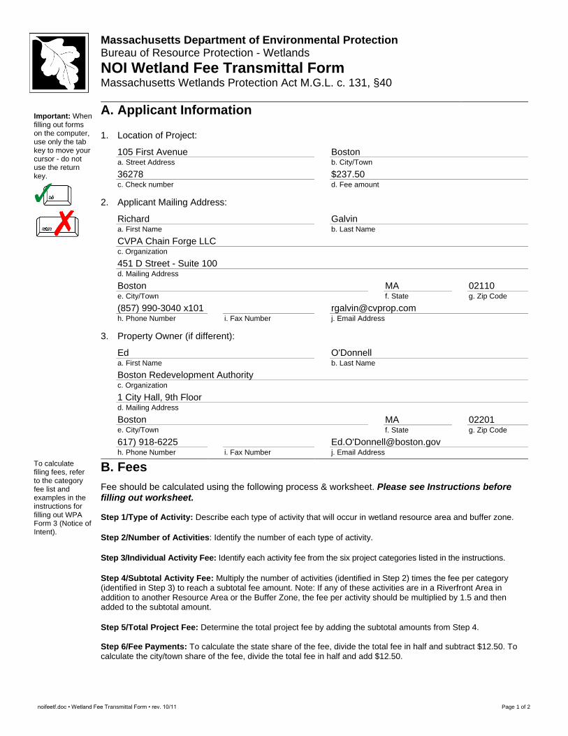
1. Location of Project:
105 First Avenue a. Street Address
Boston b. City/Town
36278 c. Check number
$237.50 d. Fee amount
2. Applicant Mailing Address:
Richard a. First Name
Galvin b. Last Name
CVPA Chain Forge LLC c. Organization 451 D Street - Suite 100 d. Mailing Address Boston e. City/Town
MA f. State
02110 g. Zip Code
(857) 990-3040 x101 h. Phone Number
i. Fax Number
[email protected] j. Email Address
3. Property Owner (if different):
Ed a. First Name
O'Donnell b. Last Name
Boston Redevelopment Authority c. Organization
1 City Hall, 9th Floor d. Mailing Address
Boston e. City/Town
MA f. State
02201 g. Zip Code
617) 918-6225 h. Phone Number
i. Fax Number
Ed.O'[email protected] j. Email Address
To calculate filing fees, refer to the category fee list and examples in the instructions for filling out WPA Form 3 (Notice of Intent).
B. Fees
Fee should be calculated using the following process & worksheet. Please see Instructions before filling out worksheet. Step 1/Type of Activity: Describe each type of activity that will occur in wetland resource area and buffer zone. Step 2/Number of Activities: Identify the number of each type of activity. Step 3/Individual Activity Fee: Identify each activity fee from the six project categories listed in the instructions. Step 4/Subtotal Activity Fee: Multiply the number of activities (identified in Step 2) times the fee per category (identified in Step 3) to reach a subtotal fee amount. Note: If any of these activities are in a Riverfront Area in addition to another Resource Area or the Buffer Zone, the fee per activity should be multiplied by 1.5 and then added to the subtotal amount. Step 5/Total Project Fee: Determine the total project fee by adding the subtotal amounts from Step 4. Step 6/Fee Payments: To calculate the state share of the fee, divide the total fee in half and subtract $12.50. To calculate the city/town share of the fee, divide the total fee in half and add $12.50.

noifeetf.doc • Wetland Fee Transmittal Form • rev. 10/11 Page 2 of 2
Massachusetts Department of Environmental Protection Bureau of Resource Protection - Wetlands NOI Wetland Fee Transmittal Form Massachusetts Wetlands Protection Act M.G.L. c. 131, §40
B. Fees (continued) Step 1/Type of Activity Step 2/Number
of Activities Step
3/Individual Activity Fee
Step 4/Subtotal Activity Fee
Cat 2J Limited work in LSCSF
1
500
$500
Step 5/Total Project Fee:
Step 6/Fee Payments:
Total Project Fee: $500.00
a. Total Fee from Step 5 State share of filing Fee: $237.50
b. 1/2 Total Fee less $12.50 City/Town share of filling Fee: $1500.00 (Local fee)
c. 1/2 Total Fee plus $12.50
C. Submittal Requirements
a.) Complete pages 1 and 2 and send with a check or money order for the state share of the fee, payable to the Commonwealth of Massachusetts.
Department of Environmental Protection
Box 4062 Boston, MA 02211
b.) To the Conservation Commission: Send the Notice of Intent or Abbreviated Notice of Intent; a copy of
this form; and the city/town fee payment.
To MassDEP Regional Office (see Instructions): Send a copy of the Notice of Intent or Abbreviated Notice of Intent; a copy of this form; and a copy of the state fee payment. (E-filers of Notices of Intent may submit these electronically.)

Attachment E
Abutter Notification Information
Figure 4Abutters Map - City of Boston Assessing (2017)
Chain Forge - 105 First Avenue Boston, Massachusetts
G:\Projects2\MA\Boston\5090\MXD\abutters.mxd Data Source: Office of Geographic Information (MassGIS), Commonwealth of Massachusetts, Information Technology Division
LEGENDProject Site
100' Radius
Abutting Parcel (Parcel ID)
Parcel Boundary
°0 50 10025Feet1 inch = 100 feet
Scale 1:1,200
NOTIFICATION TO ABUTTERS UNDER THE MASSACHUSETTS WETLAND PROTECTION ACT
In accordance with the second paragraph of Massachusetts General Laws Chapter 131, Section 40, you are hereby notified of the following: A. The name of the applicant is XX. B. The applicant has filed a Notice of Intent application with the Boston Conservation
Commission seeking an Order of Conditions which authorizes XXX subject to jurisdiction under the Massachusetts Wetlands Protection Act (General Laws Chapter 131, Section 40). Project activities will impact Land Subject to Coastal Storm Flowage.
C. The address of the lot where the activity is proposed is 105 First Avenue.
D. Copies of the NOI and site plans may be examined or obtained for a fee from either the:
Copies of the Notice of Intent may be examined at the Copies of the NOI and site plans may be examined at the Boston Conservation Commission office located at City Hall, Room 709 Monday through Friday 8:30 am to 5:30 pm. Please call for an appointment (617-635-3850). Please leave a message on the voice mail if no one is available to answer the phone. Copy fees may be applicable.
Copies of the NOI and site plans may be obtained from the applicant’s representative, Epsilon Associates, Inc, by calling 978-897-7100 between the hours of 9:00 a.m. and 5:00 p.m., Monday through Friday.
E. Information regarding the time, date and place of the public hearing may also be
obtained from the Boston Conservation Commission by calling 617-635-3850 Monday through Friday 8:30 am to 5:30 pm. It is anticipated that a public hearing will be held on March 21, 2018 but please contact the Conservation Commission to confirm the meeting date, time and location.
NOTE: Notice of the public hearing, including its date, time and place, will be published at least five (5) days in advance in the Boston Herald. NOTE: Notice of the public hearing, including its date, time and place, will be posted in City Hall at least forty-eight (48) hours in advance. NOTE: You also may contact the Conservation Commission or the Northeast Regional Department of Environmental Protection for more information about this application or the Wetlands Protection Act. To contact the Northeast Regional Department of Environmental Protection Office, call (978) 694-3200.

PID_LONG YEAR PID ZIPCODE LU
0203506010 2017 0203506010 02129 Condominium main
0203510152 2017 0203510152 02129 Tax‐exempt
0203510175 2017 0203510175 02129 Condominium main
0203510451 2017 0203510451 02129 Tax‐exempt
0203511100 2017 0203511100 02129 Tax‐exempt
0203511300 2017 0203511300 02129 Tax‐exempt
0203511400 2017 0203511400 02129 Condominium main
0203515525 2017 0203515525 02129 Residential 7 or more units
0203515600 2017 0203515600 02129 Condominium main
0203515760 2017 0203515760 02129 Residential 7 or more units
0203517500 2017 0203517500 02129 Condominium main
OWNER AV_LAND AV_BLDG AV_TOTAL GROSS_TAX LAND_SF
THE PARRIS LANDING COND TRST 0 0 0 0.00000000000 230251
BOSTON REDEVELOPMENT AUTH 3136700 0 3136700 0.00000000000 52078
BASILICA LEASEHOLD 0 0 0 0.00000000000 93542
CONSTITUTION OFFICE PARK LE 39788700 152796300 192585000 0.00000000000 99974
BOSTON REDEVELOPMENT AUTH 1736000 0 1736000 0.00000000000 25688
YMCA OF GREATER BOSTON INC 4047800 3954200 8002000 0.00000000000 14762
STARBOARD LEASEHOLD 0 0 0 0.00000000000 15362
BUILDING 103 ASSOC LP 6701000 11239000 17940000 189984.60000000000 45474
SHIPWAYS CONDOMINIUM ASSN 0 0 0 0.00000000000 143926
BRICKLAYERS BUILDING 104 LLC 2014500 1365000 3379500 35838.91000000000 23289
CHARLESTOWN NAVY YARD 0 0 0 0.00000000000 28820

LIVING_ARE GIS_ID FULL_ADDRE
0 0203506010 42 EIGHTH ST, 02129
0 0203510152 75 THIRTEENTH ST, 02129
0 0203510175 SIXTEENTH ST, 02129
704270 0203510451 THIRTEENTH ST, 02129
0 0203511100 SEVENTH ST, 02129
106000 0203511300 150 THIRD AV, 02129
0 0203511400 45 FIRST ST, 02129
81000 0203515525 NINTH ST, 02129
0 0203515600 FIRST AV, 02129
59849 0203515760 FIRST AV, 02129
0 0203517500 77 A‐103 THIRTEENTH ST, 02129

Affidavit of Service
Under The Massachusetts Wetlands Protection Act ------------------------------------------------------------------------------------------------- I, Alyssa Jacobs, hereby certify under the pains and penalties of perjury that on March 7, 2018, Epsilon Associates, Inc. gave notification to abutters in compliance with the second paragraph of Massachusetts General Laws Chapter 131, Section 40, the DEP Guide to Abutter Notification dated April 8, 1994 in connection with the following matter:
A Notice of Intent application was filed under the Massachusetts Wetland Protection Act by Chain Forge LLC on March 7, 2018 for property located at 105 First Avenue in Boston, MA.
The form of notification, and a list of the abutters to whom it was given and their addresses are attached to this Affidavit of Service.
March 7, 2018
Alyssa Jacobs, PWS DATE Senior Consultant
Attachment F
Site Plans and Stormwater Checklist Form

3845 Checklist for Stormwater Report 03�06�18.doc • 04/01/08 Stormwater Report Checklist • Page 1 of 8
Massachusetts Department of Environmental Protection Bureau of Resource Protection � Wetlands Program
Checklist for Stormwater Report
A. Introduction
Important: When filling out forms on the computer, use only the tab key to move your cursor � do not use the return key.
A Stormwater Report must be submitted with the Notice of Intent permit application to document compliance with the Stormwater Management Standards. The following checklist is NOT a substitute for the Stormwater Report (which should provide more substantive and detailed information) but is offered here as a tool to help the applicant organize their Stormwater Management documentation for their Report and for the reviewer to assess this information in a consistent format. As noted in the Checklist, the Stormwater Report must contain the engineering computations and supporting information set forth in Volume 3 of the Massachusetts Stormwater Handbook. The Stormwater Report must be prepared and certified by a Registered Professional Engineer (RPE) licensed in the Commonwealth. The Stormwater Report must include:
• The Stormwater Checklist completed and stamped by a Registered Professional Engineer (see page 2) that certifies that the Stormwater Report contains all required submittals.
1 This Checklist
is to be used as the cover for the completed Stormwater Report.
• Applicant/Project Name
• Project Address
• Name of Firm and Registered Professional Engineer that prepared the Report
• Long�Term Pollution Prevention Plan required by Standards 4�6
• Construction Period Pollution Prevention and Erosion and Sedimentation Control Plan required by Standard 8
2
• Operation and Maintenance Plan required by Standard 9 In addition to all plans and supporting information, the Stormwater Report must include a brief narrative describing stormwater management practices, including environmentally sensitive site design and LID techniques, along with a diagram depicting runoff through the proposed BMP treatment train. Plans are required to show existing and proposed conditions, identify all wetland resource areas, NRCS soil types, critical areas, Land Uses with Higher Potential Pollutant Loads (LUHPPL), and any areas on the site where infiltration rate is greater than 2.4 inches per hour. The Plans shall identify the drainage areas for both existing and proposed conditions at a scale that enables verification of supporting calculations.
As noted in the Checklist, the Stormwater Management Report shall document compliance with each of the Stormwater Management Standards as provided in the Massachusetts Stormwater Handbook. The soils evaluation and calculations shall be done using the methodologies set forth in Volume 3 of the Massachusetts Stormwater Handbook. To ensure that the Stormwater Report is complete, applicants are required to fill in the Stormwater Report Checklist by checking the box to indicate that the specified information has been included in the Stormwater Report. If any of the information specified in the checklist has not been submitted, the applicant must provide an explanation. The completed Stormwater Report Checklist and Certification must be submitted with the Stormwater Report.
1 The Stormwater Report may also include the Illicit Discharge Compliance Statement required by Standard 10. If not included in
the Stormwater Report, the Illicit Discharge Compliance Statement must be submitted prior to the discharge of stormwater runoff to the post�construction best management practices. 2 For some complex projects, it may not be possible to include the Construction Period Erosion and Sedimentation Control Plan in
the Stormwater Report. In that event, the issuing authority has the discretion to issue an Order of Conditions that approves the project and includes a condition requiring the proponent to submit the Construction Period Erosion and Sedimentation Control Plan before commencing any land disturbance activity on the site.
3845 Checklist for Stormwater Report 03�06�18.doc • 04/01/08 Stormwater Report Checklist • Page 2 of 8
Massachusetts Department of Environmental Protection Bureau of Resource Protection � Wetlands Program
Checklist for Stormwater Report
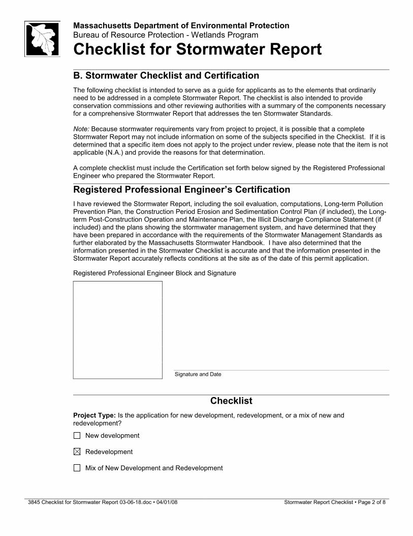
B. Stormwater Checklist and Certification
The following checklist is intended to serve as a guide for applicants as to the elements that ordinarily need to be addressed in a complete Stormwater Report. The checklist is also intended to provide conservation commissions and other reviewing authorities with a summary of the components necessary for a comprehensive Stormwater Report that addresses the ten Stormwater Standards. Note: Because stormwater requirements vary from project to project, it is possible that a complete Stormwater Report may not include information on some of the subjects specified in the Checklist. If it is determined that a specific item does not apply to the project under review, please note that the item is not applicable (N.A.) and provide the reasons for that determination. A complete checklist must include the Certification set forth below signed by the Registered Professional Engineer who prepared the Stormwater Report.
Registered Professional Engineer’s Certification
I have reviewed the Stormwater Report, including the soil evaluation, computations, Long�term Pollution Prevention Plan, the Construction Period Erosion and Sedimentation Control Plan (if included), the Long�term Post�Construction Operation and Maintenance Plan, the Illicit Discharge Compliance Statement (if included) and the plans showing the stormwater management system, and have determined that they have been prepared in accordance with the requirements of the Stormwater Management Standards as further elaborated by the Massachusetts Stormwater Handbook. I have also determined that the information presented in the Stormwater Checklist is accurate and that the information presented in the Stormwater Report accurately reflects conditions at the site as of the date of this permit application.
Registered Professional Engineer Block and Signature
Signature and Date
Checklist
Project Type: Is the application for new development, redevelopment, or a mix of new and redevelopment?
New development
Redevelopment
Mix of New Development and Redevelopment
3845 Checklist for Stormwater Report 03�06�18.doc • 04/01/08 Stormwater Report Checklist • Page 3 of 8
Massachusetts Department of Environmental Protection Bureau of Resource Protection � Wetlands Program
Checklist for Stormwater Report
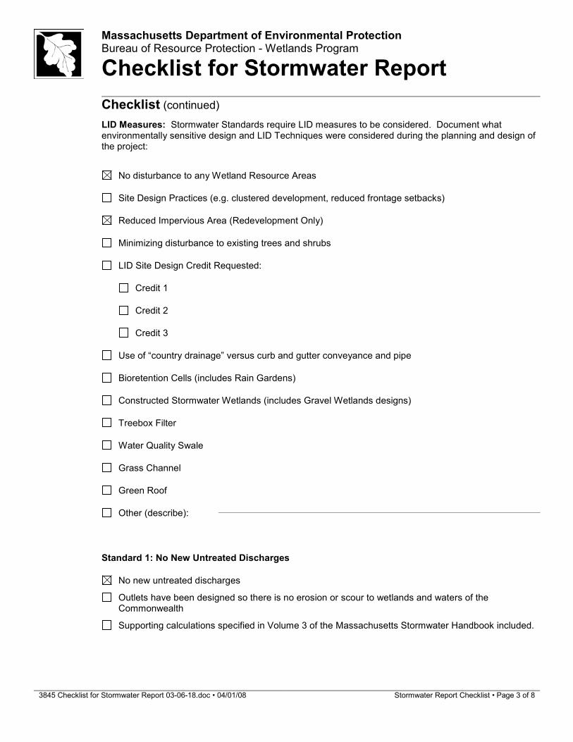
Checklist (continued)
LID Measures: Stormwater Standards require LID measures to be considered. Document what environmentally sensitive design and LID Techniques were considered during the planning and design of the project:
No disturbance to any Wetland Resource Areas
Site Design Practices (e.g. clustered development, reduced frontage setbacks)
Reduced Impervious Area (Redevelopment Only)
Minimizing disturbance to existing trees and shrubs
LID Site Design Credit Requested:
Credit 1
Credit 2
Credit 3
Use of “country drainage” versus curb and gutter conveyance and pipe
Bioretention Cells (includes Rain Gardens)
Constructed Stormwater Wetlands (includes Gravel Wetlands designs)
Treebox Filter
Water Quality Swale
Grass Channel
Green Roof
Other (describe):
Standard 1: No New Untreated Discharges
No new untreated discharges
Outlets have been designed so there is no erosion or scour to wetlands and waters of the Commonwealth
Supporting calculations specified in Volume 3 of the Massachusetts Stormwater Handbook included.
3845 Checklist for Stormwater Report 03�06�18.doc • 04/01/08 Stormwater Report Checklist • Page 4 of 8
Massachusetts Department of Environmental Protection Bureau of Resource Protection � Wetlands Program
Checklist for Stormwater Report
Checklist (continued)
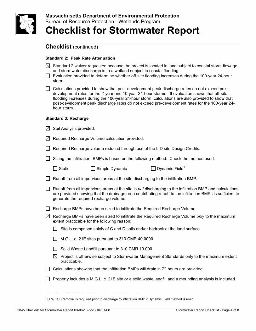
Standard 2: Peak Rate Attenuation
Standard 2 waiver requested because the project is located in land subject to coastal storm flowage and stormwater discharge is to a wetland subject to coastal flooding.
Evaluation provided to determine whether off�site flooding increases during the 100�year 24�hour storm.
Calculations provided to show that post�development peak discharge rates do not exceed pre�
development rates for the 2�year and 10�year 24�hour storms. If evaluation shows that off�site flooding increases during the 100�year 24�hour storm, calculations are also provided to show that post�development peak discharge rates do not exceed pre�development rates for the 100�year 24�hour storm.
Standard 3: Recharge
Soil Analysis provided.
Required Recharge Volume calculation provided.
Required Recharge volume reduced through use of the LID site Design Credits.
Sizing the infiltration, BMPs is based on the following method: Check the method used.
Static Simple Dynamic Dynamic Field
1
Runoff from all impervious areas at the site discharging to the infiltration BMP.
Runoff from all impervious areas at the site is not discharging to the infiltration BMP and calculations
are provided showing that the drainage area contributing runoff to the infiltration BMPs is sufficient to generate the required recharge volume.
Recharge BMPs have been sized to infiltrate the Required Recharge Volume.
Recharge BMPs have been sized to infiltrate the Required Recharge Volume only to the maximum extent practicable for the following reason:
Site is comprised solely of C and D soils and/or bedrock at the land surface
M.G.L. c. 21E sites pursuant to 310 CMR 40.0000
Solid Waste Landfill pursuant to 310 CMR 19.000
Project is otherwise subject to Stormwater Management Standards only to the maximum extent practicable.
Calculations showing that the infiltration BMPs will drain in 72 hours are provided.
Property includes a M.G.L. c. 21E site or a solid waste landfill and a mounding analysis is included.
1 80% TSS removal is required prior to discharge to infiltration BMP if Dynamic Field method is used.

3845 Checklist for Stormwater Report 03�06�18.doc • 04/01/08 Stormwater Report Checklist • Page 5 of 8
Massachusetts Department of Environmental Protection Bureau of Resource Protection � Wetlands Program
Checklist for Stormwater Report
Checklist (continued)
Standard 3: Recharge (continued)
The infiltration BMP is used to attenuate peak flows during storms greater than or equal to the 10�
year 24�hour storm and separation to seasonal high groundwater is less than 4 feet and a mounding analysis is provided.
Documentation is provided showing that infiltration BMPs do not adversely impact nearby wetland resource areas.
Standard 4: Water Quality
The Long�Term Pollution Prevention Plan typically includes the following:
• Good housekeeping practices;
• Provisions for storing materials and waste products inside or under cover;
• Vehicle washing controls;
• Requirements for routine inspections and maintenance of stormwater BMPs;
• Spill prevention and response plans;
• Provisions for maintenance of lawns, gardens, and other landscaped areas;
• Requirements for storage and use of fertilizers, herbicides, and pesticides;
• Pet waste management provisions;
• Provisions for operation and management of septic systems;
• Provisions for solid waste management;
• Snow disposal and plowing plans relative to Wetland Resource Areas;
• Winter Road Salt and/or Sand Use and Storage restrictions;
• Street sweeping schedules;
• Provisions for prevention of illicit discharges to the stormwater management system;
• Documentation that Stormwater BMPs are designed to provide for shutdown and containment in the event of a spill or discharges to or near critical areas or from LUHPPL;
• Training for staff or personnel involved with implementing Long�Term Pollution Prevention Plan;
• List of Emergency contacts for implementing Long�Term Pollution Prevention Plan.
A Long�Term Pollution Prevention Plan is attached to Stormwater Report and is included as an attachment to the Wetlands Notice of Intent.
Treatment BMPs subject to the 44% TSS removal pretreatment requirement and the one inch rule for calculating the water quality volume are included, and discharge:
is within the Zone II or Interim Wellhead Protection Area
is near or to other critical areas
is within soils with a rapid infiltration rate (greater than 2.4 inches per hour)
involves runoff from land uses with higher potential pollutant loads.
The Required Water Quality Volume is reduced through use of the LID site Design Credits.
Calculations documenting that the treatment train meets the 80% TSS removal requirement and, if applicable, the 44% TSS removal pretreatment requirement, are provided.

3845 Checklist for Stormwater Report 03�06�18.doc • 04/01/08 Stormwater Report Checklist • Page 6 of 8
Massachusetts Department of Environmental Protection Bureau of Resource Protection � Wetlands Program
Checklist for Stormwater Report
Checklist (continued)
Standard 4: Water Quality (continued)
The BMP is sized (and calculations provided) based on:
The ½” or 1” Water Quality Volume or
The equivalent flow rate associated with the Water Quality Volume and documentation is provided showing that the BMP treats the required water quality volume.
The applicant proposes to use proprietary BMPs, and documentation supporting use of proprietary
BMP and proposed TSS removal rate is provided. This documentation may be in the form of the propriety BMP checklist found in Volume 2, Chapter 4 of the Massachusetts Stormwater Handbook and submitting copies of the TARP Report, STEP Report, and/or other third party studies verifying performance of the proprietary BMPs.
A TMDL exists that indicates a need to reduce pollutants other than TSS and documentation showing
that the BMPs selected are consistent with the TMDL is provided.
Standard 5: Land Uses With Higher Potential Pollutant Loads (LUHPPLs)
The NPDES Multi�Sector General Permit covers the land use and the Stormwater Pollution
Prevention Plan (SWPPP) has been included with the Stormwater Report.
The NPDES Multi�Sector General Permit covers the land use and the SWPPP will be submitted prior
to the discharge of stormwater to the post�construction stormwater BMPs.
The NPDES Multi�Sector General Permit does not cover the land use.
LUHPPLs are located at the site and industry specific source control and pollution prevention measures have been proposed to reduce or eliminate the exposure of LUHPPLs to rain, snow, snow melt and runoff, and been included in the long term Pollution Prevention Plan.
All exposure has been eliminated.
All exposure has not been eliminated and all BMPs selected are on MassDEP LUHPPL list.
The LUHPPL has the potential to generate runoff with moderate to higher concentrations of oil and grease (e.g. all parking lots with >1000 vehicle trips per day) and the treatment train includes an oil grit separator, a filtering bioretention area, a sand filter or equivalent.
Standard 6: Critical Areas
The discharge is near or to a critical area and the treatment train includes only BMPs that MassDEP
has approved for stormwater discharges to or near that particular class of critical area.
Critical areas and BMPs are identified in the Stormwater Report.

3845 Checklist for Stormwater Report 03�06�18.doc • 04/01/08 Stormwater Report Checklist • Page 7 of 8
Massachusetts Department of Environmental Protection Bureau of Resource Protection � Wetlands Program
Checklist for Stormwater Report
Checklist (continued)
Standard 7: Redevelopments and Other Projects Subject to the Standards only to the maximum extent practicable
The project is subject to the Stormwater Management Standards only to the maximum Extent
Practicable as a:
Limited Project
Small Residential Projects: 5�9 single family houses or 5�9 units in a multi�family development
provided there is no discharge that may potentially affect a critical area.
Small Residential Projects: 2�4 single family houses or 2�4 units in a multi�family development with a discharge to a critical area
Marina and/or boatyard provided the hull painting, service and maintenance areas are protected
from exposure to rain, snow, snow melt and runoff
Bike Path and/or Foot Path
Redevelopment Project
Redevelopment portion of mix of new and redevelopment.
Certain standards are not fully met (Standard No. 1, 8, 9, and 10 must always be fully met) and an
explanation of why these standards are not met is contained in the Stormwater Report.
The project involves redevelopment and a description of all measures that have been taken to
improve existing conditions is provided in the Stormwater Report. The redevelopment checklist found in Volume 2 Chapter 3 of the Massachusetts Stormwater Handbook may be used to document that the proposed stormwater management system (a) complies with Standards 2, 3 and the pretreatment and structural BMP requirements of Standards 4�6 to the maximum extent practicable and (b) improves existing conditions.
Standard 8: Construction Period Pollution Prevention and Erosion and Sedimentation Control
A Construction Period Pollution Prevention and Erosion and Sedimentation Control Plan must include the following information:
• Narrative;
• Construction Period Operation and Maintenance Plan;
• Names of Persons or Entity Responsible for Plan Compliance;
• Construction Period Pollution Prevention Measures;
• Erosion and Sedimentation Control Plan Drawings;
• Detail drawings and specifications for erosion control BMPs, including sizing calculations;
• Vegetation Planning;
• Site Development Plan;
• Construction Sequencing Plan;
• Sequencing of Erosion and Sedimentation Controls;
• Operation and Maintenance of Erosion and Sedimentation Controls;
• Inspection Schedule;
• Maintenance Schedule;
• Inspection and Maintenance Log Form.
A Construction Period Pollution Prevention and Erosion and Sedimentation Control Plan containing
the information set forth above has been included in the Stormwater Report.

3845 Checklist for Stormwater Report 03�06�18.doc • 04/01/08 Stormwater Report Checklist • Page 8 of 8
Massachusetts Department of Environmental Protection Bureau of Resource Protection � Wetlands Program
Checklist for Stormwater Report
Checklist (continued)
Standard 8: Construction Period Pollution Prevention and Erosion and Sedimentation Control (continued)
The project is highly complex and information is included in the Stormwater Report that explains why it is not possible to submit the Construction Period Pollution Prevention and Erosion and Sedimentation Control Plan with the application. A Construction Period Pollution Prevention and Erosion and Sedimentation Control has not been included in the Stormwater Report but will be submitted before land disturbance begins.
The project is not covered by a NPDES Construction General Permit.
The project is covered by a NPDES Construction General Permit and a copy of the SWPPP is in the
Stormwater Report.
The project is covered by a NPDES Construction General Permit but no SWPPP been submitted.
The SWPPP will be submitted BEFORE land disturbance begins.
Standard 9: Operation and Maintenance Plan
The Post Construction Operation and Maintenance Plan is included in the Stormwater Report and
includes the following information:
Name of the stormwater management system owners;
Party responsible for operation and maintenance;
Schedule for implementation of routine and non�routine maintenance tasks;
Plan showing the location of all stormwater BMPs maintenance access areas;
Description and delineation of public safety features;
Estimated operation and maintenance budget; and
Operation and Maintenance Log Form.
The responsible party is not the owner of the parcel where the BMP is located and the Stormwater
Report includes the following submissions:
A copy of the legal instrument (deed, homeowner’s association, utility trust or other legal entity) that establishes the terms of and legal responsibility for the operation and maintenance of the project site stormwater BMPs;
A plan and easement deed that allows site access for the legal entity to operate and maintain
BMP functions.
Standard 10: Prohibition of Illicit Discharges
The Long�Term Pollution Prevention Plan includes measures to prevent illicit discharges;
An Illicit Discharge Compliance Statement is attached;
NO Illicit Discharge Compliance Statement is attached but will be submitted prior to the discharge of
any stormwater to post�construction BMPs.
ARCHITECT
PROJECT NAME
CLIENT
PROJECT TEAM
REVISIONS
DRAWING TITLE
DRAWING INFORMATION
DRAWING NUMBER
Bargmann Hendrie + Archetype, Inc.
300 A Street
Boston, MA 02210
617 350-0450 Tel
Copyright BH+A, Inc.
DATE OF ISSUE
DESCRIPTION
SCALE DRAWN BY
PROJECT # FILE NAME
1
2
3
4
DATE
+abh
3183_Chain Forge_Central
105 First Avenue
Charlestown, MA 02109
5
D:\R
evit\3
18
3_C
hain
Fo
rge
_R
201
7_a
ho
nsa
ker@
bh
plu
s.c
om
.rvt
10
/27/2
01
7 6
:49
:44
PM
A000
Cover Sheet
DS
3183
October 27, 2017
The ChainForge Hotel
CV Properties451 D StreetBoston MA 02210
AHA Consulting Engineers24 Hartwell Avenue, 3rd FloorLexington, MA 02421
(781) 372-3000
MEP/FP Engineer
McNamara Salvia101 Federal Street, 11th FloorBoston, MA 02110
(617) 737-0040
Structural Engineer
HW Moore Associates, Inc.112 Shawmut Ave,Boston, MA 02118
(617) 357-8145
Civil Engineer
Kyle Zick Landscape Architecture36 Bromfield Street, Suite 202Boston, MA 02108
(617) 451-1018
Landscape Engineer
DS
THE CHAIN FORGE HOTELCHARLESTOWN, MA
March 6, 2018
Conservation Commission
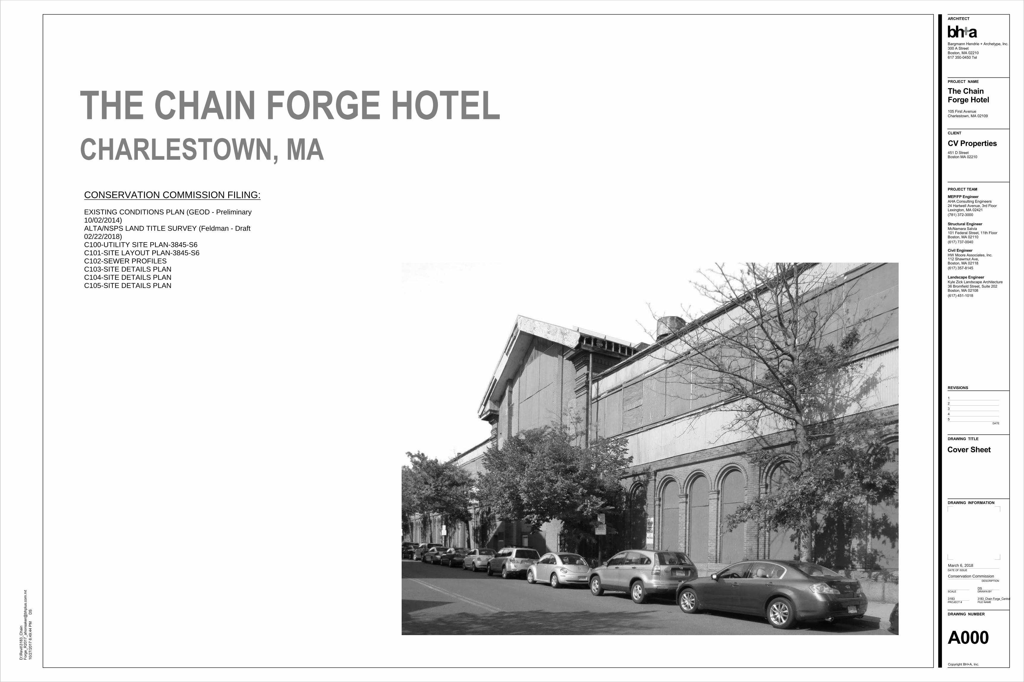
CONSERVATION COMMISSION FILING:
EXISTING CONDITIONS PLAN (GEOD - Preliminary10/02/2014) ALTA/NSPS LAND TITLE SURVEY (Feldman - Draft02/22/2018)C100-UTILITY SITE PLAN-3845-S6C101-SITE LAYOUT PLAN-3845-S6C102-SEWER PROFILESC103-SITE DETAILS PLANC104-SITE DETAILS PLANC105-SITE DETAILS PLAN


S
SS
S
SS
S
D
D
D
D
D
D
D
D
D
E
T
C
D
C
TFIRST AVENUE
THIR
TEE
NTH
STR
EE
T
NIN
TH
S
TRE
ET
C
NSTARSWITCH
NSTARTRANS.
File
Nam
e: C
:\384
5\38
45-S
6.dw
g S
aved
3/6
/201
8 1:
40 P
M P
lotte
d: M
ar 0
6, 2
018
1:40
:42p
mTa
b: C
100
Plo
t Sty
le: 1
050C
.ctb
Plo
tted
By:
Joh
n G
ethe
rall
ARCHITECT
PROJECT NAME
CLIENT
PROJECT TEAM
Bargmann Hendrie + Archetype, Inc.300 A StreetBoston, MA 02210617 350-0450 Tel
+abh
105 First AvenueCharlestown, MA 02109
The ChainForge Hotel
CV Properties
451 D StreetBoston MA 02210
AHA Consulting Engineers24 Hartwell Avenue, 3rd FloorLexington, MA 02421(781) 372-3000
MEP/FP Engineer
McNamara Salvia101 Federal Street, 11th FloorBoston, MA 02110(617) 737-0040
Structural Engineer
HW Moore Associates, Inc.112 Shawmut Ave,Boston, MA 02118(617) 357-8145
Civil Engineer
Kyle Zick Landscape Architecture36 Bromfield Street, Suite 202Boston, MA 02108(617) 451-1018
Landscape Engineer
REVISIONS
DRAWING TITLE
DRAWING INFORMATION
DRAWING NUMBER
Copyright BH+A, Inc.
DATE OF ISSUE
DESCRIPTION
SCALE DRAWN BY
PROJECT # FILE NAME
1234
DATE
C-100BWSC#
Utility Site Plan
3845-S6.dwg Saved: 3/6/2018 1:40 PM Plotted: Mar 06, 2018 1:40:pm
LAND USE CODE: "C" - COMMERCIAL
STORMWATER INFILTRATION CALCULATIONS
DESIGN RUNOFF VOLUME:
USE 1/2 INCH RAINFALL EVENT PER 9-20-2017 DISCUSSION WITH BWSC.PROPOSED LEASE AREA = 64,684 S.F.
RUNOFF VOLUME = 64,684 S.F. x 1/2"/12" = 2,695 C.F.
DESIGN VOLUME = 2,700 C.F.
PROPOSED INFILTRATION SYSTEM STORAGE VOLUME
USE 45 LEACHING GALLEYS WITH CRUSHED STONE
GALLEY VOLUME = (4'x4'x3') x 45 GALLEYS = 2,160 C.F.
STONE VOLUME = [(6'x90'x4') +(6'x94'x4') - 2,160 C.F.] x 0.3 VOIDS = 676.8 C.F.
TOTAL VOLUME PROVIDED = 2,160 C.F. + 676.8 C.F. = 2,836.8 C.F.
STORMWATER STORAGE VOLUME = 2,836.8 C.F. > 2,700 C.F.
SERVICE CONNECTION TABLEITEM BWSC INSPECTOR/DATEQTY
SPECIAL CONDITIONSITEM BWSC INSPECTOR/DATEAS-BUILT PLAN
CONDITIONS LETTER
NOTES:
1. LOCATIONS AND ELEVATIONS OF UNDERGROUND PIPES AND CONDUITS HAVE BEEN DETERMINED FROMTHE REFERENCED PLAN AND SHALL BE VERIFIED BY THE CONTRACTOR PRIOR TO CONSTRUCTION. H.W.MOORE ASSOCIATES, INC. ASSUMES NO RESPONSIBILITY FOR DAMAGES INCURRED AS A RESULT OFUTILITIES INACCURATELY SHOWN OR OMITTED. BEFORE PLANNING FUTURE CONNECTIONS, THE PROPERUTILITY DEPARTMENT SHALL BE NOTIFIED AND THE ACTUAL LOCATIONS OF SUBSURFACE STRUCTURESSHALL BE VERIFIED IN THE FIELD. CALL THE BWSC, (617)989-7000 AND DIG-SAFE CALL CENTER,(888)344-7233, 72 HOURS (3 WORKING DAYS) PRIOR TO EXCAVATION.
2. ALL CONSTRUCTION METHODS AND MATERIALS SHALL CONFORM TO BWSC REQUIREMENTS AND ALLOTHER APPLICABLE MUNICIPAL REGULATIONS.
3. ALL DISTURBANCES WITHIN THE TRAVELED WAYS SHALL CONFORM TO CITY AND BWSC STANDARDS.
4. THIS PLAN HAS BEEN PREPARED FOR APPROVAL OF THE WATER, DRAIN AND SEWER CONNECTIONS TOTHE BWSC FACILITIES. IT IS UNDERSTOOD THAT THE RESPONSIBILITY OF OWNERSHIP AND MAINTENANCEOF THE SEWER CONNECTIONS ON PRIVATE PROPERTY AND/OR PRIVATE AND PUBLIC WAYS SHALL BE THERESPONSIBILITY OF THE DEVELOPER AND/OR OWNERS. IT IS ALSO UNDERSTOOD THAT THE WATERCONNECTIONS ON PRIVATE PROPERTY INCLUDING PRIVATE WAYS ARE ALSO THE RESPONSIBILITY OF THEDEVELOPER AND/OR OWNERS. IF THE CONNECTIONS CROSS, OR ARE NEAR INDIVIDUAL PROPERTY LINES,PROVISIONS MUST BE MADE TO ALLOW EACH OWNER TO MAINTAIN OR RECONSTRUCT THEIRRESPECTIVE CONNECTIONS. THIS FACT MUST BE INCORPORATED INTO ANY PURCHASE AND SALESAGREEMENT AND DEEDS RELATED TO THE TRANSFER OF OWNERSHIP OF THE PROPERTIES.
5. THE PROPOSED BUILDING CONNECTIONS (BY PLUMBER) SHALL BE 10' OUTSIDE THE FOUNDATION WALL.
6. SITE CONTRACTOR TO PROVIDE ALL EXCAVATION, INSTALLATION, BACK FILLING, PAVEMENT PATCHING,ETC. FOR THE INSTALLATION OF UNDERGROUND GAS, ELECTRIC, TELEPHONE, FIRE ALARM, WATER,SEWER, DRAIN AND SIMILAR SERVICES.
7. IF EXISTING ABANDONED BWSC SERVICES ARE ENCOUNTERED THEY SHALL BE CUT AND CAPPED AT THEMAIN PER BWSC STANDARDS.
8. THE SEWER GRAVITY PIPE SHALL BE POLYVINYL CHLORIDE (PVC) PIPE SDR 35 CONFORMING TO ASTMSTANDARD SPECIFICATIONS D3034 UNLESS OTHERWISE NOTED.
9. STORM DRAIN PIPES SHALL BE POLYVINYL CHLORIDE (PVC) PIPE SDR 35 CONFORMING TO ASTMSTANDARD SPECIFICATIONS D3034.
10. CONTRACTOR IS TO OBTAIN THE ROUGH CONSTRUCTION SIGN OFF DOCUMENT FROM THE CITY OFBOSTON INSPECTIONAL SERVICES DEPARTMENT PRIOR TO FILING A GENERAL SERVICES APPLICATIONWITH BWSC.
11. CONTRACTOR WILL BE RESPONSIBLE FOR PREPARING AS-BUILT PLANS IN ACCORDANCE WITH BWSCREQUIREMENTS.
12. CONTRACTOR TO CONFIRM THE LOCATIONS AND INVERTS OF THE EXISTING UTILITIES IN THE STREETPRIOR TO THE INSTALLATION OF NEW SERVICE CONNECTIONS. SERVICES SHALL BE FIELD VERIFIEDBEFORE BEGINNING CONSTRUCTION.
13. ANY CONSTRUCTION DEWATERING SHALL EMPLOY MEASURES TO FILTER OUT SEDIMENT PRIOR TO ITSDISCHARGE AND SHALL CONFORM WITH BWSC REQUIREMENTS. CONTRACTOR TO SUBMIT A SKETCH OFTHESE TO THE ARCHITECT FOR APPROVAL.
14. CONTRACTOR TO EMPLOY MEASURES TO CONTROL DUST DURING CONSTRUCTION.
15. RIM ELEVATIONS OF DRAINAGE STRUCTURES ARE APPROXIMATE. FINAL ELEVATIONS ARE TO BE SETFLUSH. ADJUST ALL OTHER RIM ELEVATIONS OF EXISTING MANHOLES, WATER GATES, GAS GATES ANDOTHER UTILITIES TO FINISHED GRADE WITHIN LIMITS OF SITE WORK.
16. THE CONTRACTOR SHALL MAKE ALL ARRANGEMENTS FOR THE ALTERATION AND ADJUSTMENT OF GAS,ELECTRIC, TELEPHONE, FIRE ALARM AND OTHER PRIVATE COMPANIES, AS REQUIRED.
17. COORDINATE CATV, TELEPHONE AND GAS INSTALLATION WITH THE UTILITY COMPANIES.
18. LOCATIONS OF "CUT & CAPS" FOR THE EXISTING BUILDINGS UTILITY SERVICES ARE APPROXIMATE ONLY.CONTRACTOR SHALL VERIFY THE LOCATION OF EXISTING SERVICES TO BE CUT & CAPPED PRIOR TOSTART OF WORK.
19. FIRE AND DOMESTIC SERVICES SHALL BE DUCTILE IRON, MANUFACTURED IN ACCORDANCE WITH THEREQUIREMENTS OF ANSI/AWWA C151/A21.51 AND SHALL BE CLASS 56. JOINTS SHALL BE INSTALLED WITHMEGALUG MECHANICAL JOINTS OR EQUAL. DUE TO CORROSIVE SOILS IN THIS AREA, ALL NEW WATERPIPE SHALL BE ZINC COATED PER BWSC SPECIFICATIONS.
20. SEE PLUMBING PLANS FOR ALL PIPE WORK WITHIN BUILDING.
21. SEE ARCHITECTURAL PLANS FOR COMPONENTS OF EXISTING BUILDING TO BE DEMOLISHED AND/ORSALVAGED.
22. THE RIM ELEVATIONS OF ALL UTILITY STRUCTURES WITHIN THE LIMITS OF WORK SHALL BE ADJUSTED TOFINISHED GRADE.
23. CONTRACTOR TO SAWCUT EXISTING PAVEMENTS FOR PROPOSED UTILITY TRENCHES.
RESERVED FOR BWSC USE
Account Number
Property Location
Project Name
Neighborhood
Type of Premise
Parcel Number Ward
Extended Zip Code
105 FIRST AVENUE
THE CHAIN FORGE HOTEL
02129
HOTEL / RESTAURANT
CHARLESTOWN
PROPERTY INFORMATION
WATER METER INFORMATION
EXISTING BWSC WATER ACCOUNT No. :
EXISTING WATER METER No. :
EXISTING WATER METER SIZE =
ANTICIPATED SEWAGE FLOWHOTEL: 230 ROOMS x 110 GPD/ROOM 25,300 GPD
14,000 GPDRESTAURANT:
=
=
39,300 GPD=ANTICIPATED SEWAGE FLOW
400 SEATS x 35 GPD/SEAT
APPLICANTCV PROPERTIES451 D STREETBOSTON, MA 02210
OWNERBOSTON REDEVELOPMENT AUTHORITYONE CITY HALL SQUAREBOSTON, MA 02201-1007
HORIZONTAL GRAPHIC SCALE IN FEET
20 20100 40
1"=20'
NOI Submission
March 6, 2018
REFERENCES:
1. EXISTING CONDITIONS, PROPERTY LINES, UTILITIES AND GRADES TAKEN FROM A PLAN TITLED "EXISTINGCONDITIONS PLAN LOCATED AT 105 FIRST AVENUE CHARLESTOWN, MASSACHUSETTS" DATED OCTOBER2, 2014, PREPARED BY GEOD CONSULTING. THIS FILE WAS RECEIVED BY EMAIL ON SEPTEMBER 14, 2017FROM BARGMANN HENDRIE + ARCHETYPE THIS PLAN WAS ISSUED BY GEOD CONSULTING AS A"PROGRESS PRINT".
2. PROPOSED BUILDING REHABILITATION PLANS TAKEN FROM A FILE NAMED A101 - First Floor.dwg RECEIVEDBY EMAIL ON SEPTEMBER 14, 2017 FROM BARGMANN HENDRIE + ARCHETYPE.
3. FEMA FLOOD ZONE LINE DELINEATING ZONE "X" AND ZONE "AE" HAS BEEN TAKEN FROM A DIGITAL FILEOF A PLAN TITLED "ALTA/NSPS LAND TITLE SURVEY, 105 FIRST AVENUE, BOSTON, (CHARLESTOWN) MASS."AND DATED APRIL 26, 2017 AND PREPARED BY FELDMAN LAND SURVEYORS OF BOSTON, MA. DIGITAL FILERECEIVED ON FEBRUARY 22, 2018.
S
SS
S
SS
S
D
D
D
D
D
D
D
D
D
E
T
C
D
C
TFIRST AVENUE
THIR
TEE
NTH
STR
EE
T
NIN
TH
S
TRE
ET
C
UP
UP
UP
UP
DN
5,870 SF
Back ofHouse /Mech
5,880 SF
Restaurant/ Dining
1,410 SFReceiving
1,530 SF
Hotel /BanquetKitchen
1,200 SF
RestaurantKitchen
PreFunctionLobby
Men Women
GuestRoom
GuestRoom
GuestRoom
GuestRoom
GuestRoom
GuestRoom
GuestRoom
GuestRoom
GuestRoom
GuestRoom
GuestRoom
1,830 SF
ClubLounge 2,190 SF
Fitness
HospitalitySuite
HospitalitySuite
HospitalitySuite
Stair 3
Stair 7
Stair 8
HospitalitySuite
GuestRoom
GuestRoom
1,270 SFCafe Ballroom
Men WomenStair 2
NSTARSWITCH
NSTARTRANS.
File
Nam
e: C
:\384
5\38
45-S
6.dw
g S
aved
3/6
/201
8 2:
10 P
M P
lotte
d: M
ar 0
6, 2
018
2:11
:03p
mTa
b: C
101
Plo
t Sty
le: 1
050C
.ctb
Plo
tted
By:
Joh
n G
ethe
rall
ARCHITECT
PROJECT NAME
CLIENT
PROJECT TEAM
Bargmann Hendrie + Archetype, Inc.300 A StreetBoston, MA 02210617 350-0450 Tel
+abh
105 First AvenueCharlestown, MA 02109
The ChainForge Hotel
CV Properties
451 D StreetBoston MA 02210
AHA Consulting Engineers24 Hartwell Avenue, 3rd FloorLexington, MA 02421(781) 372-3000
MEP/FP Engineer
McNamara Salvia101 Federal Street, 11th FloorBoston, MA 02110(617) 737-0040
Structural Engineer
HW Moore Associates, Inc.112 Shawmut Ave,Boston, MA 02118(617) 357-8145
Civil Engineer
Kyle Zick Landscape Architecture36 Bromfield Street, Suite 202Boston, MA 02108(617) 451-1018
Landscape Engineer
REVISIONS
DRAWING TITLE
DRAWING INFORMATION
DRAWING NUMBER
Copyright BH+A, Inc.
DATE OF ISSUE
DESCRIPTION
SCALE DRAWN BY
PROJECT # FILE NAME
1234
DATE
1"=20'
C-101
Site Layout Plan
3845-S6.dwg Saved: 3/6/2018 2:10 PM Plotted: Mar 06, 2018 2:11:pm
REFERENCES:
1. EXISTING CONDITIONS, PROPERTY LINES, UTILITIES AND GRADES TAKEN FROM APLAN TITLED "EXISTING CONDITIONS PLAN LOCATED AT 105 FIRST AVENUECHARLESTOWN, MASSACHUSETTS" DATED OCTOBER 2, 2014, PREPARED BYGEOD CONSULTING. THIS FILE WAS RECEIVED BY EMAIL ON SEPTEMBER 14,2017 FROM BARGMANN HENDRIE + ARCHETYPE THIS PLAN WAS ISSUED BYGEOD CONSULTING AS A "PROGRESS PRINT".
2. PROPOSED BUILDING REHABILITATION PLANS TAKEN FROM A FILE NAMED A101 -First Floor.dwg RECEIVED BY EMAIL ON SEPTEMBER 14, 2017 FROM BARGMANNHENDRIE + ARCHETYPE.
NOI Submission
March 6, 2018
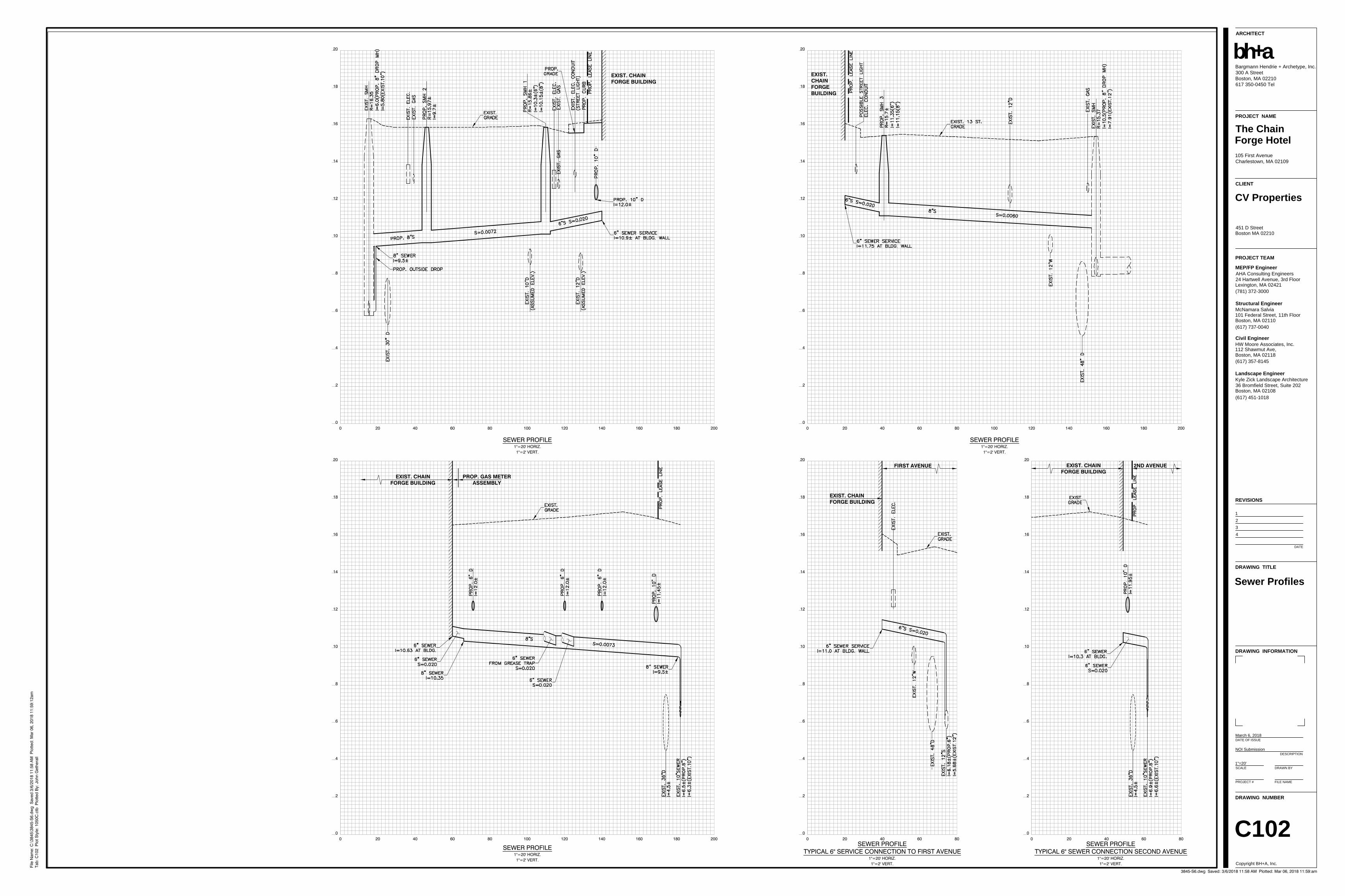
00
4
8
40 80
SEWER PROFILE1"=20' HORIZ.1"=2' VERT.
20 60 100
2
6
10
12
16
20
14
18
120 140 160 180 200
EXIST. CHAINFORGE BUILDING
00
4
8
40 80
SEWER PROFILE1"=20' HORIZ.1"=2' VERT.
20 60 100
2
6
10
12
16
20
14
18
120 140 160 180 200
EXIST.CHAINFORGEBUILDING
00
4
8
40 80SEWER PROFILE
TYPICAL 6" SERVICE CONNECTION TO FIRST AVENUE1"=20' HORIZ.1"=2' VERT.
20 60
2
6
10
12
16
20
14
18 EXIST. CHAINFORGE BUILDING
FIRST AVENUE
00
4
8
40 80
SEWER PROFILE1"=20' HORIZ.1"=2' VERT.
20 60 100
2
6
10
12
16
20
14
18
120 140 160 180 200
EXIST. CHAINFORGE BUILDING
PROP. GAS METERASSEMBLY
00
4
8
40 80SEWER PROFILE
TYPICAL 6" SEWER CONNECTION SECOND AVENUE1"=20' HORIZ.1"=2' VERT.
20 60
2
6
10
12
16
20
14
18
EXIST. CHAINFORGE BUILDING
2ND AVENUE
File
Nam
e: C
:\384
5\38
45-S
6.dw
g S
aved
3/6
/201
8 11
:58
AM
Plo
tted:
Mar
06,
201
8 11
:59:
12am
Tab:
C10
2 P
lot S
tyle
: 105
0C.c
tb P
lotte
d B
y: J
ohn
Get
hera
llARCHITECT
PROJECT NAME
CLIENT
PROJECT TEAM
Bargmann Hendrie + Archetype, Inc.300 A StreetBoston, MA 02210617 350-0450 Tel
+abh
105 First AvenueCharlestown, MA 02109
The ChainForge Hotel
CV Properties
451 D StreetBoston MA 02210
AHA Consulting Engineers24 Hartwell Avenue, 3rd FloorLexington, MA 02421(781) 372-3000
MEP/FP Engineer
McNamara Salvia101 Federal Street, 11th FloorBoston, MA 02110(617) 737-0040
Structural Engineer
HW Moore Associates, Inc.112 Shawmut Ave,Boston, MA 02118(617) 357-8145
Civil Engineer
Kyle Zick Landscape Architecture36 Bromfield Street, Suite 202Boston, MA 02108(617) 451-1018
Landscape Engineer
REVISIONS
DRAWING TITLE
DRAWING INFORMATION
DRAWING NUMBER
Copyright BH+A, Inc.
DATE OF ISSUE
DESCRIPTION
SCALE DRAWN BY
PROJECT # FILE NAME
1234
DATE
C102
Sewer Profiles
3845-S6.dwg Saved: 3/6/2018 11:58 AM Plotted: Mar 06, 2018 11:59:am
1"=20'
NOI Submission
March 6, 2018
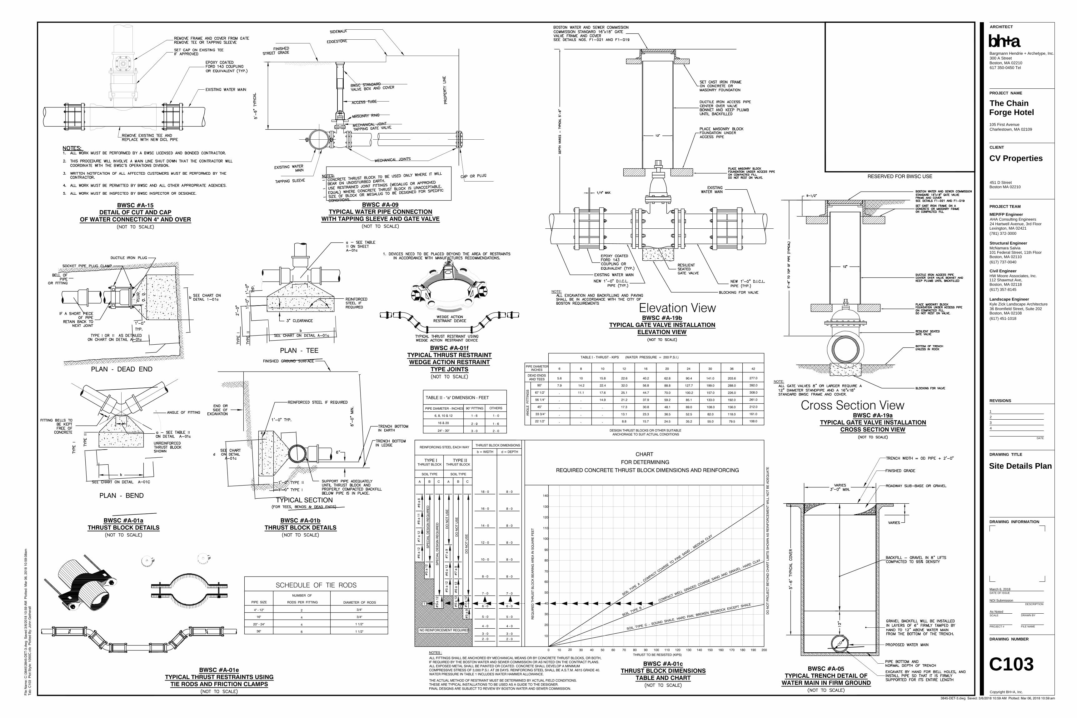
OD
BWSC #A-05TYPICAL TRENCH DETAIL OF
WATER MAIN IN FIRM GROUND
PIPE SIZE
SCHEDULE OF TIE RODSNUMBER OF
RODS PER FITTING DIAMETER OF RODS
4" - 12"
20" - 24"
16"
36"
2 3/4"
1 1/2"
4
4
6
3/4"
1 1/2"
I II
II
I
II
PLAN - DEAD END
PLAN - BEND
II
I II
PLAN - TEE
TYPICAL SECTION
II
I
3 - 0
2 - 0
24" - 30"
16 & 20
OTHERS90° FITTING
TABLE II - "a" DIMENSION - FEET
PIPE DIAMETER - INCHES
6, 8, 10 & 12 1 - 6 1 - 0
1 - 6
2 - 0
INCHESPIPE DIAMETER
AN
GLE
FIT
TIN
GS
DEAD ENDSAND TEES
90°
67 1/2°
56 1/4°
45°
33 3/4°
22 1/2°
6 8 10 12 16 20 24 30 36 42
5.6
7.9
-
-
-
-
- -
-
-
-
-
-
-
10
14.2
11.1 17.6
14.9
22.4
15.8 22.6
32.0
25.1
21.2
17.3
13.1
8.8
40.2
56.8
44.7
37.9
30.8
23.3
15.7
62.8
88.8
70.0
59.2
48.1
36.5
24.5 35.2
52.5
69.0
85.1
100.2
127.7
90.4 141.0
199.0
157.0
133.0
108.0
82.0
55.0 79.5
118.0
156.0
192.0
226.0
288.0
203.6 277.0
392.0
308.0
261.0
212.0
161.0
108.0
TABLE I - THRUST - KIPS (WATER PRESSURE = 200 P.S.I.)
CHARTFOR DETERMINING
REQUIRED CONCRETE THRUST BLOCK DIMENSIONS AND REINFORCING
10
20
30
40
50
60
70
80
90
100
110
120
130
140
20 20019018017016015014013012011010090807060504030100
REINFORCING STEEL EACH WAY
TYPE ITHRUST BLOCK
SOIL TYPE
TYPE IITHRUST BLOCK
A AB BC C
RE
QU
IRE
D T
HR
US
T B
LOC
K B
EA
RIN
G A
RE
A IN
SQ
UA
RE
FE
ET
DO
NO
T P
RO
JEC
T B
EY
ON
D C
HA
RT
LIM
ITS
SH
OW
N A
S R
EIN
FOR
CE
ME
NT
WIL
L N
OT
BE
AD
EQ
UA
TE
THRUST TO BE RESISTED (KIPS)ALL FITTINGS SHALL BE ANCHORED BY MECHANICAL MEANS OR BY CONCRETE THRUST BLOCKS, OR BOTH,IF REQUIRED BY THE BOSTON WATER AND SEWER COMMISSION OR AS NOTED ON THE CONTRACT PLANS.ALL EXPOSED METAL SHALL BE PAINTED OR COATED. CONCRETE SHALL DEVELOP A MINIMUMCOMPRESSIVE STRESS OF 3,000 P.S.I. AT 28 DAYS. REINFORCING STEEL SHALL BE A.S.T.M. A615 GRADE 40.WATER PRESSURE IN TABLE 1 INCLUDES WATER HAMMER ALLOWANCE.
NOTES :
THE ACTUAL METHOD OF RESTRAINT MUST BE DETERMINED BY ACTUAL FIELD CONDITIONS.THESE ARE TYPICAL INSTALLATIONS TO BE USED AS A GUIDE TO THE DESIGNER.FINAL DESIGNS ARE SUBJECT TO REVIEW BY BOSTON WATER AND SEWER COMMISSION.
SOIL TYPE
THRUST BLOCK DIMENSIONS
b = WIDTH d = DEPTH
#6
a 12
#7
a 12
#8
a 11
#8
a 8
SP
EC
IAL
DE
SIG
N R
EQ
UIR
ED
SP
EC
IAL
DE
SIG
N R
EQ
UIR
ED
DO
NO
T U
SE
DO
NO
T U
SE
DO
NO
T U
SE
#5
a 12
#5
a 12
#7
a 9
#6
a 12
#5
a 12
#6
a 12
#7
a 9
#5
a 12
#7
a 12
#5
a 9
18 - 0 8 - 0
16 - 0 8 - 0
14 - 0 8 - 0
12 - 0 8 - 0
10 - 0 8 - 0
8 - 0 8 - 0
7 - 07 - 0
6 - 0 6 - 0
5 - 0 5 - 0
4 - 0 4 - 0
3 - 0 3 - 0
2 - 0 2 - 0
NO REINFORCEMENT REQUIRED
21
SOIL TYPE A
- COMPACT C
OARSE TO F
INE SAND -
MEDIUM C
LAY
SOIL TYPE C - SOUND SHALE, HARD PAN, BROKEN BEDROCK EXCEPT SHALE
DESIGN THRUST BLOCKS OR OTHER SUITABLE ANCHORAGE TO SUIT ACTUAL CONDITIONS
SOIL TYPE B -
COMPACT WELL GRADED COARSE SAND AND GRAVEL - HARD CLAY
BWSC #A-01aTHRUST BLOCK DETAILS
BWSC #A-01bTHRUST BLOCK DETAILS
BWSC #A-01cTHRUST BLOCK DIMENSIONS
TABLE AND CHARTBWSC #A-01e
TYPICAL THRUST RESTRAINTS USINGTIE RODS AND FRICTION CLAMPS
BWSC #A-01fTYPICAL THRUST RESTRAINTWEDGE ACTION RESTRAINT
TYPE JOINTS
BWSC #A-09TYPICAL WATER PIPE CONNECTION
WITH TAPPING SLEEVE AND GATE VALVE
BWSC #A-15DETAIL OF CUT AND CAP
OF WATER CONNECTION 4" AND OVER
NOTE:
Elevation ViewBWSC #A-19b
TYPICAL GATE VALVE INSTALLATIONELEVATION VIEW
BWSC #A-19aTYPICAL GATE VALVE INSTALLATION
CROSS SECTION VIEW
NOTE:
Cross Section View
RESERVED FOR BWSC USE
File
Nam
e: C
:\384
5\38
45-D
ET-
3.dw
g S
aved
3/6
/201
8 10
:59
AM
Plo
tted:
Mar
06,
201
8 10
:59:
08am
Tab:
C10
3 P
lot S
tyle
: 105
0C.c
tb P
lotte
d B
y: J
ohn
Get
hera
llARCHITECT
PROJECT NAME
CLIENT
PROJECT TEAM
Bargmann Hendrie + Archetype, Inc.300 A StreetBoston, MA 02210617 350-0450 Tel
+abh
105 First AvenueCharlestown, MA 02109
The ChainForge Hotel
CV Properties
451 D StreetBoston MA 02210
AHA Consulting Engineers24 Hartwell Avenue, 3rd FloorLexington, MA 02421(781) 372-3000
MEP/FP Engineer
McNamara Salvia101 Federal Street, 11th FloorBoston, MA 02110(617) 737-0040
Structural Engineer
HW Moore Associates, Inc.112 Shawmut Ave,Boston, MA 02118(617) 357-8145
Civil Engineer
Kyle Zick Landscape Architecture36 Bromfield Street, Suite 202Boston, MA 02108(617) 451-1018
Landscape Engineer
REVISIONS
DRAWING TITLE
DRAWING INFORMATION
DRAWING NUMBER
Copyright BH+A, Inc.
DATE OF ISSUE
DESCRIPTION
SCALE DRAWN BY
PROJECT # FILE NAME
1234
DATE
C103
Site Details Plan
3845-DET-3.dwg Saved: 3/6/2018 10:59 AM Plotted: Mar 06, 2018 10:59:am
As Noted
NOI Submission
March 6, 2018

BWSC #M-01CORRECT PLUMBING
FOR METER INSTALLATION
BWSC #B-09TRENCH DETAIL FOR P.V.C. PIPE
BWSC #B-12bTYPICAL SADDLE CONNECTION TO
EXISTING DRAIN OR SEWER
NOTES:1. ALL CAST IN PLACE CONCRETE TO HAVE A MINIMUM 28 DAY STRENGTH OF 3000 LBS PER SQ. INCH, USING
3/4"MAXIMUM SIZE AGGREGATE.
2. REINFORCING STEEL BARS ARE DEFORMED BARS OF BILLET STEEL ASTM A615 GRADE 60.
3. WELDED WIRE FABRIC CONFORMS TO ASTM A185.
4. CAST IRON FRAME, TYPE "A" AND COVER TYPE "A" FOR DETAILS SEE DETAILS NOS. F1-D01, F1-D04 AND F1-D05.COVERS TO BE MARKED EITHER "SEWER" OR "DRAIN".
5. DESIGN LIVE LOAD - HS 20 - 44.
6. MINIMUM COVER FOR REINFORCING IN WALLS OR SLABS POURED AGAINST EARTH SHALL BE 3 INCHES. ALLOTHERS SHALL BE 2 INCHES UNLESS OTHERWISE NOTED.
7. USE 2'-0" LENGTHS OF PIPE STUBS AT ALL MANHOLES FOR VC OR AC PIPE. USE 4'-0" MAX. LENGTHS OF PIPESTUBS AT ALL MANHOLES FOR RC, DI OR PVC.
8. THESE MANHOLE DETAILS TO BE USED FOR BOTH SANITARY SEWER AND STORM DRAIN MANHOLES.
9. ALL MANHOLES SHALL BE CONSTRUCTED OF REINFORCED CONCRETE. SHOP DRAWINGS SUBMITTALS SHALLSHOW ALL REINFORCING DETAILS.
10. MWRA OIL AND GREASE SEPARATOR IS USED WITHIN BUILDINGS WHERE REQUIRED BY MWRA(MASSACHUSETTS WATER RESOURCES AUTHORITY) OR DEP (DEPARTMENT OF ENVIRONMENTAL PROTECTION)REGULATION. FOR DETAILS SEE DETAIL NO. B-04. FOR BWSC APPROVED GRIT AND OIL SEPARATORS, SEEDETAIL NOS. B-17 AND B-18.
BWSC #B-02e MANHOLE STRUCTURES
GENERAL NOTES
BWSC #B-17WYE CLEANOUT DETAIL
END OF LINE CLEANOUTIN LINE CLEANOUT
£
BWSC #B-08TRENCH DETAIL FOR RCP OR DICL PIPE
END SECTION
CENTER SECTION
END SECTION
June, 2001
LG-444324ESGG444_DET.DWG
www.oldcastleprecast.comPhone: 508.336.7600 Fax: 508-336-070741 Almeida Road. Rehoboth, Massachusetts
DivisionFILE NAME:
ISSUE DATE:
4'-0" x 4'-0"x 4'-0" Leaching Galley
Copyright 2001©
LEACHING GALLEY DETAILS
A
A
SECTION A-A
BWSC #B-02aTYPICAL PRECAST
CONCRETE MANHOLE
RESERVED FOR BWSC USE
BWSC #B-15TYPICAL SEWER CHIMNEY DETAIL
File
Nam
e: C
:\384
5\38
45-D
ET-
3.dw
g S
aved
3/6
/201
8 10
:59
AM
Plo
tted:
Mar
06,
201
8 10
:59:
15am
Tab:
C10
4 P
lot S
tyle
: 105
0C.c
tb P
lotte
d B
y: J
ohn
Get
hera
llARCHITECT
PROJECT NAME
CLIENT
PROJECT TEAM
Bargmann Hendrie + Archetype, Inc.300 A StreetBoston, MA 02210617 350-0450 Tel
+abh
105 First AvenueCharlestown, MA 02109
The ChainForge Hotel
CV Properties
451 D StreetBoston MA 02210
AHA Consulting Engineers24 Hartwell Avenue, 3rd FloorLexington, MA 02421(781) 372-3000
MEP/FP Engineer
McNamara Salvia101 Federal Street, 11th FloorBoston, MA 02110(617) 737-0040
Structural Engineer
HW Moore Associates, Inc.112 Shawmut Ave,Boston, MA 02118(617) 357-8145
Civil Engineer
Kyle Zick Landscape Architecture36 Bromfield Street, Suite 202Boston, MA 02108(617) 451-1018
Landscape Engineer
REVISIONS
DRAWING TITLE
DRAWING INFORMATION
DRAWING NUMBER
Copyright BH+A, Inc.
DATE OF ISSUE
DESCRIPTION
SCALE DRAWN BY
PROJECT # FILE NAME
1234
DATE
C104
Site Details Plan
3845-DET-3.dwg Saved: 3/6/2018 10:59 AM Plotted: Mar 06, 2018 10:59:am
NOI Submission
March 6, 2018
As Noted

PLAN SECTION A-A
SECTION B-B
A
A
B B
NO. 9999 5503
BWSC #F1-D23BOSTON HARBOR "DON'T DUMP" PLAQUE
VERTICAL CURB SETTING DETAIL
BWSC #B-01fCATCH BASIN "DON'T DUMP"
SIGN INSTALLATION
SILK SACK DETAIL SECTION
CEMENT CONCRETE WALK
NOTES:
RESERVED FOR BWSC USE
SURFACE COURSE:
BASE COURSE:
FULL DEPTH CONSTRUCTION
NOTE:FINAL 1.5" OF PAVEMENT WILL BE PLACED OVER ENTIREROADWAY AT ONE TIME.
CALCIUM CHLORIDE OR WATER FOR ROADWAY DUSTCONTROL.
SURFACE COURSE:
LEVELING COURSE:
SURFACE PREPARATION:
HOT MIX ASPHALT OVERLAY
1.5" HOT MIX ASPHALT, PLACED IN ONE LAYER OFTOP COURSE MATERIAL
1" MINIMUM HOT MIX ASPHALT PLACED IN ONELAYER. LEVELING COURSE TO BE PLACED ASREQUIRED TO CREATE A TRUE CROSS-SECTIONPRIOR TO OVERLAY.
THE EXISTING SURFACE SHALL BE PREPARED BYCOLD PLANING TO SUFFICIENT DEPTHS TOACCOMMODATE THE PROPOSED PROFILE. A TACKCOAT OF BITUMEN (RS-1) SHALL BE UNIFORMLYAPPLIED BY MECHANICAL MEANS AT A RATE OF 0.05GALLONS PER SQUARE YARD. THE EXISTINGSURFACE SHALL BE CLEANED OF ALL FOREIGNMATTER AND LOOSE MATERIAL AND SHALL BE DRYBEFORE THE TACK COAT IS APPLIED.
3.5" HOT MIX ASPHALT, PLACED IN TWO COURSES,1.5" TOP COURSE MATERIAL OVER 2.0" BINDERCOURSE.
12" COMPACTED GRAVEL BORROW TYPE bOR EXISTING GRAVEL MEETING SPECIFICATIONS.
FULL DEPTH PAVEMENT SECTION
PAVEMENT NOTES
2'
1'
1'
INFILTRATION SYSTEM DETAIL
File
Nam
e: C
:\384
5\38
45-D
ET-
3.dw
g S
aved
3/6
/201
8 10
:59
AM
Plo
tted:
Mar
06,
201
8 10
:59:
23am
Tab:
C10
5 P
lot S
tyle
: 105
0C.c
tb P
lotte
d B
y: J
ohn
Get
hera
llARCHITECT
PROJECT NAME
CLIENT
PROJECT TEAM
Bargmann Hendrie + Archetype, Inc.300 A StreetBoston, MA 02210617 350-0450 Tel
+abh
105 First AvenueCharlestown, MA 02109
The ChainForge Hotel
CV Properties
451 D StreetBoston MA 02210
AHA Consulting Engineers24 Hartwell Avenue, 3rd FloorLexington, MA 02421(781) 372-3000
MEP/FP Engineer
McNamara Salvia101 Federal Street, 11th FloorBoston, MA 02110(617) 737-0040
Structural Engineer
HW Moore Associates, Inc.112 Shawmut Ave,Boston, MA 02118(617) 357-8145
Civil Engineer
Kyle Zick Landscape Architecture36 Bromfield Street, Suite 202Boston, MA 02108(617) 451-1018
Landscape Engineer
REVISIONS
DRAWING TITLE
DRAWING INFORMATION
DRAWING NUMBER
Copyright BH+A, Inc.
DATE OF ISSUE
DESCRIPTION
SCALE DRAWN BY
PROJECT # FILE NAME
1234
DATE
C105
Site Details Plan
3845-DET-3.dwg Saved: 3/6/2018 10:59 AM Plotted: Mar 06, 2018 10:59:am
NOI Submission
March 6, 2018
As Noted