the changing landscape of geospatial: the nsdi … changing landscape of geospatial: the nsdi &...
TRANSCRIPT

1Booz Allen Proprietary and Confidential Business Information - Internal use only
The Changing Landscape of Geospatial:The NSDI
&Disruptive Technology:
Isn't it Fun!
Anne Hale MiglareseBooz Allen Hamilton
JACIE
March 29, 2011
2Booz Allen Proprietary and Confidential Business Information - Internal use only
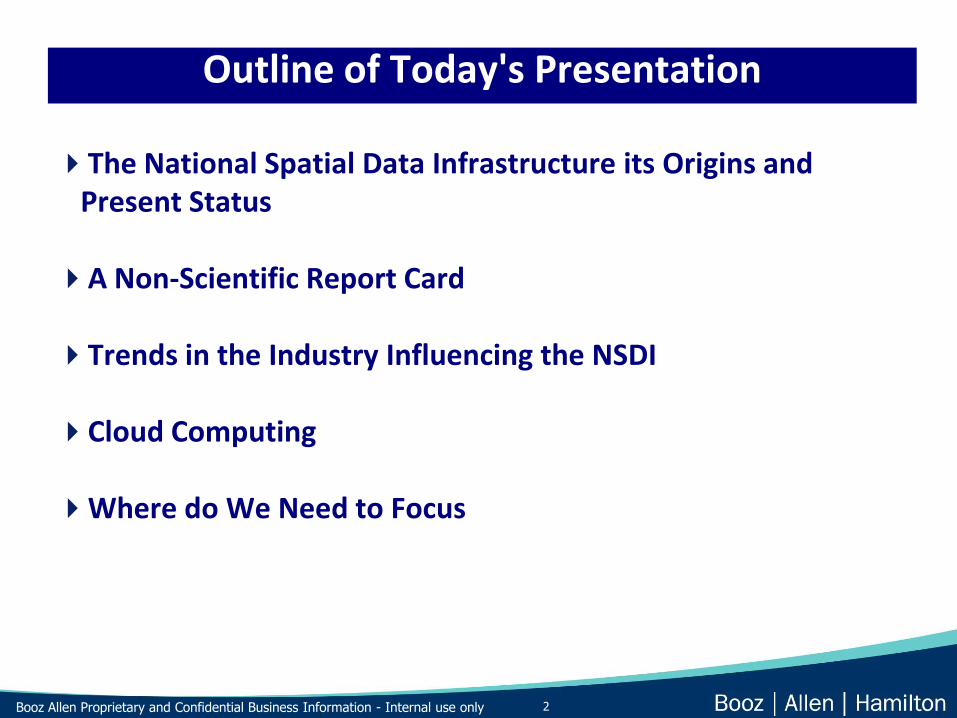
Outline of Today's Presentation
The National Spatial Data Infrastructure its Origins and Present Status
A Non-Scientific Report Card
Trends in the Industry Influencing the NSDI
Cloud Computing
Where do We Need to Focus

3Booz Allen Proprietary and Confidential Business Information - Internal use only
Components of a National Spatial Data Infrastructure (NSDI)
Policies & Institutional Arrangements (governance, data privacy & security, data sharing, business models, data licensure and publicly available data)
People (training, professional development, career models, job descriptions, certification and licensure)
Data (digital base map, thematic, statistical, place names, authoritative data and crowd sourced data)
Technology (sensors, cloud computing, hardware, software, networks, database )

4Booz Allen Proprietary and Confidential Business Information - Internal use only
Anne’s impression of the NSDI report card
Technology: A-
Data: C
People: C
Policy and Institutional Arrangements: C--

5Booz Allen Proprietary and Confidential Business Information - Internal use only
Industry Trends and the Changing Landscape
Geospatial is an International Business with Global Markets ( large investments in capital equipment, outsourcing to lower cost providers, global demand & economies of scale)
Speed of Innovation and Technology Insertion and Adoption (innovation coming from small startups and new sectors not just the from the large corporations and military)
Disruptive Technology Introduction (The digital camera, the all digital work flow, cloud computing, open source code, crowd sourcing )
Professional and Casual Consumer ( location based services market vs mission support of business applications)
• The Profession

6Booz Allen Proprietary and Confidential Business Information - Internal use only
Industry Trends and the Changing Landscape
The Profession ( not just PE’s and geographers anymore )
Embedded Technology ( integration into the CIO & CTO office, embedded in other application, smart phones)
The Data ( where it comes from, who owns it, its accuracy)
Consolidation and Diversification ( market forces driving change and opportunity in the industry)

7Booz Allen Proprietary and Confidential Business Information - Internal use only
Industry Consolidation and Diversification !
A & E Firms
System IntegratorsNational and International
Mapping Firms
Geospatial Hardware & software firms
GIS Consultants and Service Companies
Satellite & Airborne Mapping Companies
Go
ogl
e a
nd
Mic
roso
ft !
!!!

8Booz Allen Proprietary and Confidential Business Information - Internal use only
Believe it or not… just ten years ago
I built them!I paid for them!They’re MINE!
DATADATA
DATA

9Booz Allen Proprietary and Confidential Business Information - Internal use only
C’mon, won’t you share your data?
NO! If I share my data, other people will:• take credit for it• mess it up• use it for their own good!

10Booz Allen Proprietary and Confidential Business Information - Internal use only
But if you share your data, others will share their data with you…
I don’t want their stinky data –who knows where it’s been?
• How was it created?
• What sources were used?
• Were there field checks?
•What attributes, measures,methods, did they use?

11Booz Allen Proprietary and Confidential Business Information - Internal use only
Geospatial Data is Changing, Like Sands Through The Hour Glass…
Federal
State and Local
Data Fit for Use?
Federal
Data Fit for Use?
State and Local Private Sector & Volunteer Data
Fit for Use?Licensing Restrictions?
12Booz Allen Proprietary and Confidential Business Information - Internal use only
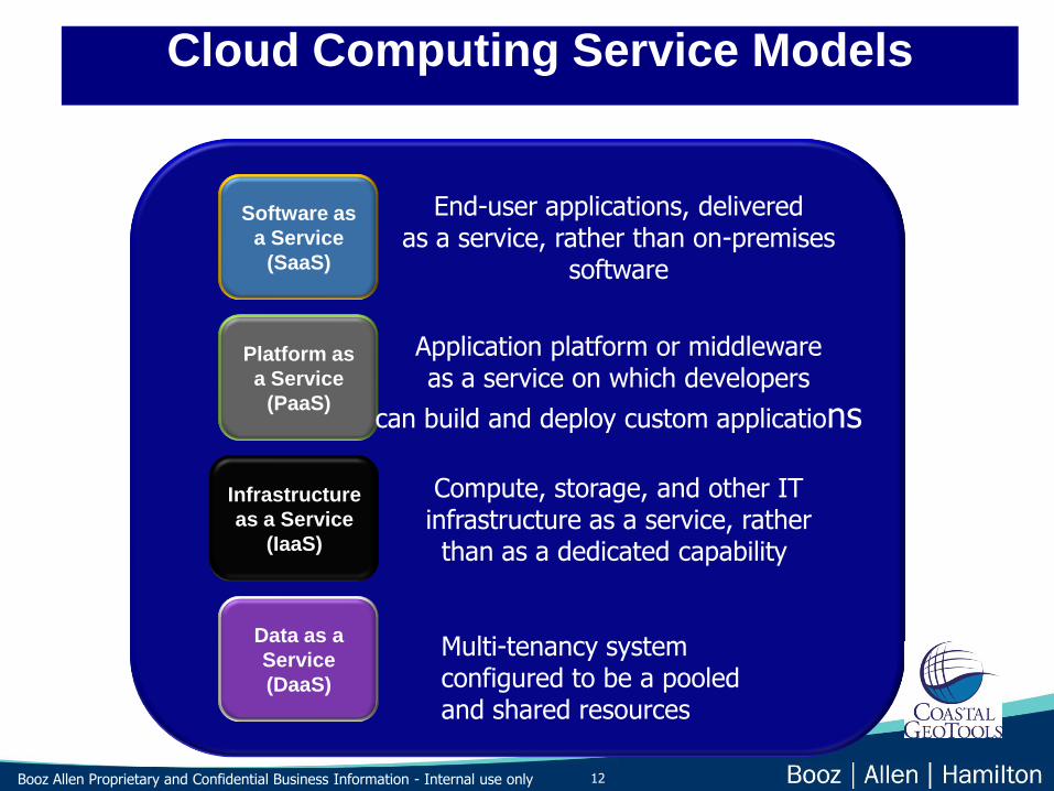
Cloud Computing Service Models
Software as
a Service
(SaaS)
Platform as
a Service
(PaaS)
Infrastructure
as a Service
(IaaS)
Data as a
Service
(DaaS)
End-user applications, deliveredas a service, rather than on-premises
software
Application platform or middlewareas a service on which developers
can build and deploy custom applications
Compute, storage, and other ITinfrastructure as a service, ratherthan as a dedicated capability
Multi-tenancy system configured to be a pooled and shared resources

13Booz Allen Proprietary and Confidential Business Information - Internal use only
CloudTypes
14Booz Allen Proprietary and Confidential Business Information - Internal use only
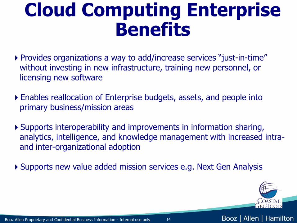
Provides organizations a way to add/increase services “just-in-time” without investing in new infrastructure, training new personnel, or licensing new software
Enables reallocation of Enterprise budgets, assets, and people into primary business/mission areas
Supports interoperability and improvements in information sharing, analytics, intelligence, and knowledge management with increased intra-and inter-organizational adoption
Supports new value added mission services e.g. Next Gen Analysis
Cloud Computing Enterprise Benefits

15Booz Allen Proprietary and Confidential Business Information - Internal use only
Speed-to-Delivery
• Allows new capability development without new infrastructure development
• Supports rapid scalability
• Diminishes constraints of scale and complexity
Cost
• Massive scale leads to true economies of scale
• Reduced complexity leads to improved sustainability and reductions in O&M costs
Information Sharing and Interoperability
• Streamlined data management
• Data availability - enabling information generation
Changing Ecosystem
• Technology inflection point, impacting client buying patterns and introducing highly capitalized non-traditional players into federal IT market e.g. Amazon, Google
Cloud Computing IT Benefits

16Booz Allen Proprietary and Confidential Business Information - Internal use only
Wordle for the Cloud

17Booz Allen Proprietary and Confidential Business Information - Internal use only
The GeoCloud Game
18Booz Allen Proprietary and Confidential Business Information - Internal use only
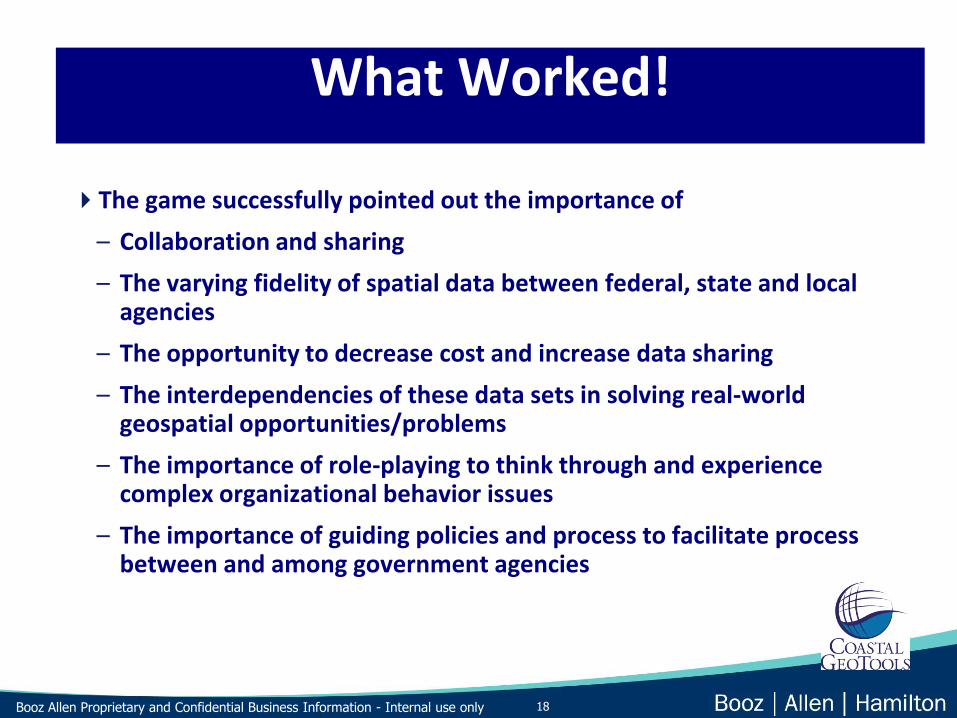
What Worked!
The game successfully pointed out the importance of
– Collaboration and sharing
– The varying fidelity of spatial data between federal, state and local agencies
– The opportunity to decrease cost and increase data sharing
– The interdependencies of these data sets in solving real-world geospatial opportunities/problems
– The importance of role-playing to think through and experience complex organizational behavior issues
– The importance of guiding policies and process to facilitate process between and among government agencies
19Booz Allen Proprietary and Confidential Business Information - Internal use only
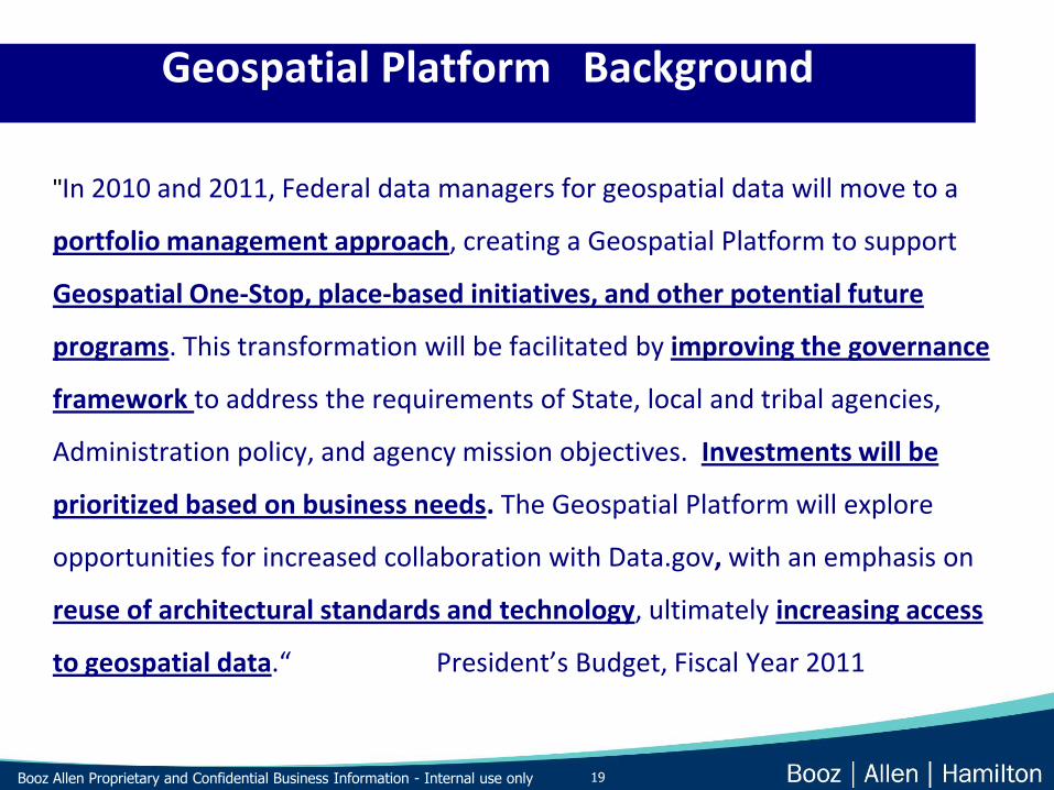
Geospatial Platform Background
"In 2010 and 2011, Federal data managers for geospatial data will move to a
portfolio management approach, creating a Geospatial Platform to support
Geospatial One-Stop, place-based initiatives, and other potential future
programs. This transformation will be facilitated by improving the governance
framework to address the requirements of State, local and tribal agencies,
Administration policy, and agency mission objectives. Investments will be
prioritized based on business needs. The Geospatial Platform will explore
opportunities for increased collaboration with Data.gov, with an emphasis on
reuse of architectural standards and technology, ultimately increasing access
to geospatial data.“ President’s Budget, Fiscal Year 2011

20Booz Allen Proprietary and Confidential Business Information - Internal use only
Definition
The Geospatial Platform will be a managed portfolio of common geospatial
data, services, and applications contributed and administered by authoritative
sources and hosted on a shared infrastructure, for use by government agencies
and partners to meet their mission needs and the broader needs of the Nation
Vision
All government agencies and their partners have access to geospatial
capabilities to meet mission needs, ensure transparency and accountability, and
geo-enable the business of government
Foundation
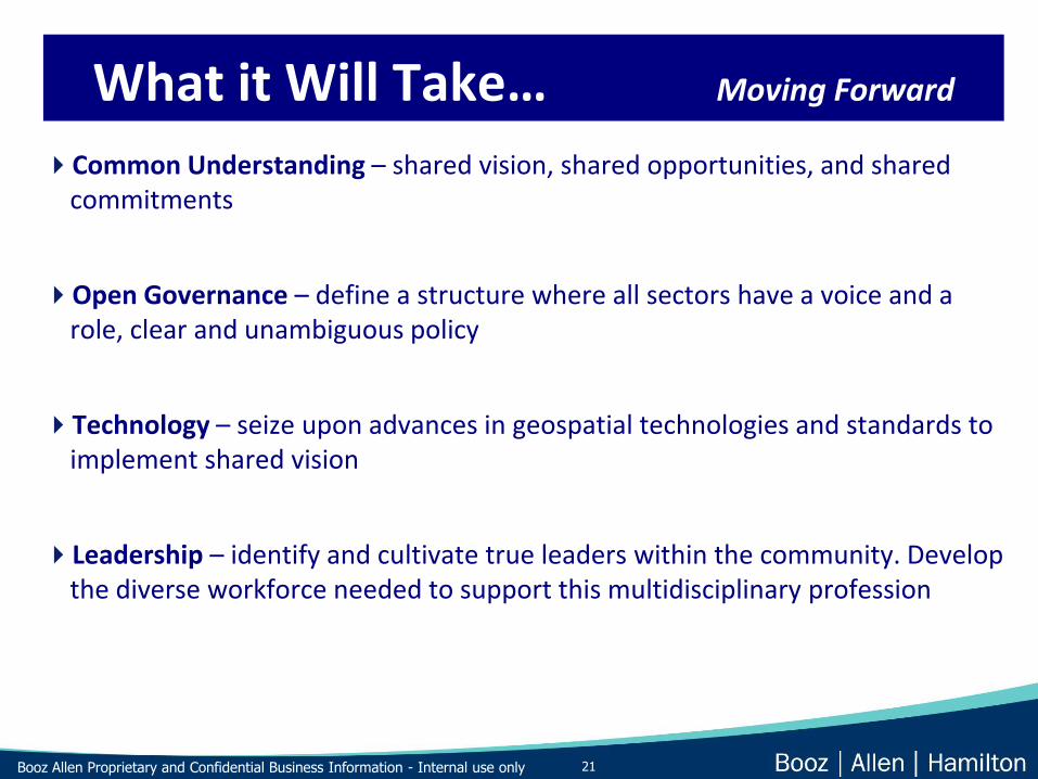
21Booz Allen Proprietary and Confidential Business Information - Internal use only
Common Understanding – shared vision, shared opportunities, and shared commitments
Open Governance – define a structure where all sectors have a voice and a role, clear and unambiguous policy
Technology – seize upon advances in geospatial technologies and standards to implement shared vision
Leadership – identify and cultivate true leaders within the community. Develop the diverse workforce needed to support this multidisciplinary profession
What it Will Take… Moving Forward

22Booz Allen Proprietary and Confidential Business Information - Internal use only
Business Model Roadmap

23Booz Allen Proprietary and Confidential Business Information - Internal use only
Open and transparent government with greater collaboration between all sectors
High quality and timely geospatial data, services and applications, easy to discover and use by all sectors of the economy
– Global Climate Change
– Green Energy
– More efficient business operations
– Etc…..
What We Could Achieve Moving Forward

24Booz Allen Proprietary and Confidential Business Information - Internal use only
Enhanced shared infrastructure and interoperability
Attain cost-savings and economies of scale through collaborative
Expand the geospatial marketplace and industry
Ensure U.S. maintains global competitiveness in the geospatial field
What We Could Achieve Moving Forward

25Booz Allen Proprietary and Confidential Business Information - Internal use only
Science to support decision making
Develop a National Geospatial Policy that is inclusive of GIS and Remote Sensing activities
The Business Model!!
Public & Private sector collaboration
Get out of the IT business
Where we need to focus Moving Forward

26Booz Allen Proprietary and Confidential Business Information - Internal use only
Questions?
Thank You

27Booz Allen Proprietary and Confidential Business Information - Internal use only
The future of imagery, remote sensing, products, and science.
Future (5 – 10 years) technology trends for remote imaging, data collection, archiving
and access. The strong need for quality imagery and Remote Sensing data in the
science community.
The value of imagery and remote sensing in support of the global earth observation
community and the importance of understanding fundamental climate variables to
support societal benefit areas.
The positive connection between Remote Sensing and science.
The value of civil and commercial remote sensing programs, systems and data. The
value of joint agency imagery collaboration, such as JACIE, to insure the collection and
use of quality data in the science community.
The pro and cons to the National Commercial Remote Sensing Space Policy.
Government’s continued need for commitment to continuing and expanding the
imagery role in the community.
The need for integrated data collection.
Image processing and storage capabilities and the doors that these technologies
open.