the city of new orleans blight fight: using gis technology
TRANSCRIPT
University of New Orleans
From the SelectedWorks of Michelle M Thompson
Spring January 5 2012
The City of New Orleans Blight Fight using GIStechnology to integrate local knowledgeMichelle M Thompson PhD University of New Orleans
Available at httpsworksbepresscommichelle_m_thompson61
The city of New Orleans blight fight using GIS technology to integrate
local knowledge
Michelle M Thompson
University of New Orleans Department of Planning amp Urban Studies amp Geography 301Milneburg Hall 2000 Lakeshore Drive New Orleans LA 70148 USA
Planners have a unique ability to consume information and address both policyand practical issues on a variety of scales ndash from neighborhood to regional tointernational The use of information technology specifically geographicinformation systems continues to expand the plannersrsquo toolkit Applying thesetools requires planners to go beyond synchronous inductive and deductivereasoning and move towards lsquointegrated thinkingrsquo Spatial literacy allows citizenplanners to question and advocate for public policies based upon community datathat has not been readily available to decision makers in municipal governmentThis report identifies examples of how a public participation geographicinformation system (PPGIS) increases engagement of stakeholders throughincreased access to and integration of municipal data Post Hurricane Katrinathe Beacon of Hope ndash University of New Orleans Community Recovery Project(BUCRP) led to a shift in citizen participation by a community-led PPGIS TheBUCRP follows standards and replicable training methods to improve accuracyand reliability of crowd sourcing data The development of tools and traditionswhere community data complements municipal resources can be used in weakmarket cities and those urban areas devastated as a result of natural or man-madedisasters
Keywords urban planning housing economic development data publicparticipation geographic information systems volunteered geographicinformation crowd sourcing
Introductionbackground
Technology is to data as data is to power The ways in which individuals canidentify create evaluate and advance uses of community data appears to be endlessThis in part is due to increased access to and integration of community andmunicipal data using public participation geographic information systems (PPGIS)One of the most important assets that government creates protects and maintains isdata In recent years rules governing the distribution of data are managed throughpublic information requests Limited access to municipal data was based upon thenotion that the public may misuse the information to adversely impact citizens andor be used to identify weaknesses in city administration andor public policies Inan effort to provide equal access to data data have not been made available arerestricted or are provided in a format that limits utility
Email mmthomp1unoedu
Housing Policy Debate
Vol 22 No 1 January 2012 101ndash115
ISSN 1051-1482 printISSN 2152-050X online
2012 Virginia Polytechnic Institute and State University
httpdxdoiorg101080105114822011634427
httpwwwtandfonlinecom
Dow
nloa
ded
by [
Tho
mas
W S
anch
ez]
at 1
353
28
June
201
5
Within the last 15 years a movement to find an equitable solution to increasingaccess to public data standardize methods from lsquobottom uprsquo (Talen 2000) datacollection has helped the lsquopublic participation GISrsquo (PPGIS) movement evolve Theunderlying motivation for a PPGIS is to partner community municipal anduniversity resources in order to improve information that can be used in anintegrated manner For the paper Public Participation GIS1 focuses on the ability toidentify information that is citizen-derived though parcel level data collection withthe aid of universities andor community advocates into a spatial environment
lsquoPublic Participation GIS is defined by Dr Renee Sieber as the use of geographicinformation systems to broaden public involvement in policymaking as well as to thevalue of GIS to promote the goals of nongovernmental organizations grassroots groupsand community based organizationsrsquo (Sieber 2006)
The new age planner must learn to balance using technology as a way to gatherinformation instead of driving the decision-making The issues of lsquotime access andtechnologyrsquo have not changed in the last ten years of using GIS (Thompson 2000)Jack Dangermond president of the Environmental Systems Research Institute(ESRI)2 suggests that planners must use integrated thinking that use
geographic information system (GIS) technology as a framework for understanding ourworld and applying geographic knowledge to solve problems and guide human behavior(2007)
In order to promote integrated thinking the PPGIS partners must have a similarunderstanding of the use development and influence that geospatial data have as adecision-making tool In general open access map resources have increased spatialliteracy lsquoMashupsrsquo Google Earth Google Streetview and other internet-based mapshave increased visibility of community data using bounded datasets Increased accessto socio-demographic data from the US Census and market segmentation data suchas Prizm from Claritas3 or Community Tapestry from ESRI4 increases public accessto spatial data that can be used to identify trends and in stable markets predictfuture actions andor estimate purchases In weak markets or cities that haveexperienced rapid decline market indicators are no longer valid For cities that haveexperienced catastrophic events such as New Orleans demographic and economicdata do not reflect current or predicted real estate purchase behaviors for example
Since August 2005 the most relevant market data have come from theneighborhood surveys collected by residents volunteers and academic institutions(some of which are non-NOLA based) While the City of New Orleans has themeans to identify and monitor problem properties due to the volume it does nothave current or accurate information on conditions of vacant abandoned orblighted properties According to the Director of Blight Policy and NeighborhoodRevitalization Jeff Hebert (2010a) lsquolsquothe issues of blight go back to the 1960s andafter (white) flight and were increased significantly after Hurricane KatrinarsquorsquoCity departments must manage this daunting task with limited resources toaccurately identify and evaluate the problem in order to distribute this information
1PPGIS httpenwikipediaorgwikiPublic_Participation_GIS2Environmental Systems Research Institute wwwesricom3Claritas Prizm Market Segmentation httpwwwclaritascomMyBestSegmentsDefaultjsp4ESRI Community Tapestry httpwwwesricomdataesri_datatapestryhtml
102 MM Thompson
Dow
nloa
ded
by [
Tho
mas
W S
anch
ez]
at 1
353
28
June
201
5
to other City departments Unfortunately the City of New Orleans GIS This wasin part due to lack of data standards centralization secure data repositorymanagerial oversight interdepartmental cooperation and the means to equitablydistribute a current accurate and reliable parcel layer file Prior to HurricanesKatrina and Rita and within five years after the inability to have a functioningmunicipal GIS has crippled the city and its ability to adequately develop acomprehensive strategy to fight blight
For those involved in moving from recovery to (economic) reinvestment thereremains a void of practical ways to collect current and reliable data so that localhousing and commercial investment can be made The related issues of identifyingthe socio-demographic characteristics are important in order to justify thedistribution of public services (eg fire stations) public accommodation (egaccessible sidewalks) or demand-driven assets such as housing and food The abilityfor the city to identify its own properties became apparent when a local activistKaren Gadbois was able to demonstrate that the wrong houses on the cityrsquos blightdemolition lists were being torn down (Winkler-Schmit 2010)
There are multiple sources of abandoned or blighted properties in the City ofNew Orleans For the purposes of this research the potential impact of a state-wideprogram to manage abandoned properties in city neighborhoods is evaluated TheLouisiana Recovery Authority (as of summer 2010 the LRA is now the Office ofCommunity Development ndash Disaster Recovery Unit5) Road Home program is acreative short-term planning solution to address a housing crisis that will haveunknown consequences for years to come The Road Home program providedaffected citizens with options for reclaimingrepairing (Option 1) or selling theirhomes (Option 2 or 3) to the Louisiana Land Trust
The merits of this program are still being debated with public outcry that thefunding for repairs or purchase was unevenly distributed due to racial bias lsquolsquoHUDhas the duty authority and ability to make sure Louisiana distributes funds forthe Road Home program fairlyrsquorsquo said Shanna L Smith president and CEO of theNational Fair Housing Alliance lsquolsquoInstead HUD allowed a formula that is biased andthreatens to undermine the recovery efforts of African-American homeowners Assuch it failed to take into account the legacy of racial discrimination in the housingmarket which has resulted in systematically lower values for homes in communitiesof colorrsquorsquo6 Reliable assessing or appraisal data were limited pre-Katrina but wascompletely unusable after since housing values completely changed after the stormThe lack of usable data affects the ability for homeowners to make rationaldecisions in and after a major crisis Citizen involvement is curtailed when data thatwould aid in their decision are overtly (and sometimes considered covertly) denied
In an effort to aid the City Code Enforcement with identifying problem andorhazardous properties that may not yet have been deemed lsquoblightrsquo or were included inany of the government-sponsored programs (including elevation grants) communitysurveys have been collected but in a more systematic and proactive manner sinceHurricane Katrina The lack of valid accurate or reliable data sets can haveunintended effects in emerging markets and create future unpredicted crisis points
5State of Louisiana Office of Community Development ndash Disaster Recovery Unit httpdoalouisianagovcdbgDRHousinghtm6Katrina An Unnatural Disaster httpwwwsorosorgresourcesmultimediakatrinablogpfrac14115
Housing Policy Debate 103
Dow
nloa
ded
by [
Tho
mas
W S
anch
ez]
at 1
353
28
June
201
5
NOLA Community-based organizations such as Beacon of Hope Resource CenterNeighborhood Housing Services of New Orleans Jericho Road HousingSquandered Heritage Broadmoor Neighborhood Project in association withHarvard University7 Gentilly Civic Association Lakeview Civic AssociationMake It Right Foundation 9th Ward Neighborhood Empowerment NetworkAssociation ACORN-NOLA and many others not identified developed a widevariety of data collection methods tools and analyses for the purposes of evaluatingthe return rates and in some cases demographic and economic profiles of returningresidents
The Road Home program which intended to lsquobring backrsquo residents and aid inneighborhood stabilization cannot yet be adequately measured There are over40000 properties in New Orleans whose owners received up to $150000 torehabilitate their primary resident within three years in the Option One ProgramThe ability of the Office of Community Development ndash Disaster Recovery Unit(OCD-DRULRA) to have ongoing monitoring was not part of the programplanning but now is being conducted through a lsquocase managementrsquo system Thisreport will evaluate a sample set of the first 2308 properties whose covenant expiredon April 30 2010 A PPGIS study with the Beacon of Hope Resource Center and theUniversity of New Orleans ndash Department of Planning amp Urban Studies conducted inspring 2010 identified some of the issues related to data management propertycondition and potential policy implications for remedial action for home owners whomay not have been in compliance
For the City of NewOrleans who at current estimates have lsquolsquoapproximately 43755blight propertiesrsquorsquo (Hebert 2010b) a fraction of the approximately 40000 Option Oneproperties could lsquolsquopotentiallyrsquorsquo add to either the abandoned or blight inventory Basedupon the BUCRP study lsquolsquothe data also suggests the state could have given as much as$500 million in federal rebuilding grants to New Orleanians who may never rebuildrsquorsquo(Hammer 2010) The map summarizes the results of this study are provided in Figure 1below
This report will provide results from a sample of Option One data collected fromMay to August 2010 This may not be generalizable to the universe of Option Oneproperties but can address the argument by OCD-DRULRA that electrical data orpostal delivery information are reasonable proxies for resident repopulation Byconducting a parcel level condition survey of 1800 properties and integrating thiswith municipal data can serve both public and private interests and add to local andregional information on neighborhood indicators from which short- and long-termreinvestment policies are basedrsquorsquo
Using GIS as a lsquolsquomiddle warersquorsquo8 solution for planning is a reality given the abilityfor technology to be the driving force to support and encourage lsquolsquotop downrsquorsquo andlsquolsquobottom uprsquorsquo social equity through the middle A recent attempt to test this middlethrough solution is the lsquoWhoDataorgrsquo internet mapping service that provides anonline environment where community property condition data city parcel informa-tion and state Option One data cohabitates on a website that allows the public tosee the present conditions while evaluating potential areas of concern or investment
7Broadmoor Neighborhood Project httpbelfercenterksgharvardeduproject54broadmoor_projecthtml8Ferreira Joseph lsquoSmart middleware for understanding neighborhood marketsrsquo httpuismitedu
104 MM Thompson
Dow
nloa
ded
by [
Tho
mas
W S
anch
ez]
at 1
353
28
June
201
5
PPGIS post-Katrina and public participation in weak market cities
The ability for state-run programs to evaluate program effectiveness at theneighborhood level remains a difficult cumbersome and very costly processMany communities have found that creating collaborative partnerships betweencommunity-based and government organizations have proven an effective way toimprove program evaluation data compatibility and exchange Since HurricanesKatrina and Rita the City of New Orleans was met with unprecedented challenges ingathering neighborhood data that are consistent timely and accurate By usingstandardized methodology and geographic information systems (GIS) universitieshave been able to assist community-based organizations with integrating neighbor-hood survey data with municipal data in a way that previously was not availablethrough the City of New Orleans such as the New Orleans RedevelopmentAuthority City of New Orleans (CNO) Planning CNO GIS andor State ofLouisiana Recovery Offices
Since 2005 resident-led organizations galvanized minimal resources to documentthe storm impact and resurgence of many neighborhoods Neighborhoods such asthe Lower 9th Ward continue to be in the national spotlight and have been used as alsquoposter childrsquo for the lack of equitable reinvestment The lack of adequate study oflost resources resident reinvestment and required city services has neither predictednor adequately documented with current and community-level data
Planners face the issue of providing equitable service to the community and areoften in a difficult position since political issues and bureaucratic guidelines haverules that must be followed
The lsquoBring Back New Orleans Commissionrsquo incorporated a community planningprocess within the Unified New Orleans Plan9 community roundtables post-KatrinaMany citizens grew weary and the media began to suggest that lsquoKatrina Fatiguersquo wasstifling the process However residents began to question why communityparticipation was required when the meetings were seen as a means unto themselvesThese experiences increased distrust of planners and the so-called communityplanning process It became clear that the theoretical application of Arnsteinrsquoslsquolsquoladder of community participationrsquorsquo (Arnstein 1969) was outmoded and impracticalfor the issues that faced New Orleans The goal for planners is to maintainobjectivity and promote equity While these may not always be achieved the publicwould increase their trust in the process if all aspects of the decision-making processare communicated and are transparent The PPGIS must consider post-event oremerging community conditions and reflect how roles and data-access changes thebalance of power and effectiveness of a community-led process The ThompsonTechnology Tree (Table 1) reflects an evolved community participation ladder modelinfused with both community-led information and technology
In this scenario there are many lsquobranchesrsquo in the development of technology-based citizen planning and the process is not linear Identifying how and when citizenscan support the management of their public resources is not solely at the discretionof the municipality As summarized in the Thompson Technology Tree and outlinedbelow the understanding of roles and interpreting these has changed over time
lsquopartnershiprsquo ndash the concept of what a partner is and what contributions aremade changes over time there are times when the initial stages of a technology
9Unified New Orleans Plan httpwwwunifiedneworleansplancomhome3
Housing Policy Debate 105
Dow
nloa
ded
by [
Tho
mas
W S
anch
ez]
at 1
353
28
June
201
5
project must be lsquodrivenrsquo by the university or municipal partner but in constantconsultation with the CBO there is significant amount of time that must betaken to educate the CBO on the benefits or risks of a particular GIS strategyso that informed decisions can be made by all
lsquodatarsquo ndash the power that data have in the ability for the partners to participate ismore important than ever access to data is becoming less onerous due to thepublic lsquoright to knowrsquo and multiple formats that are compatible with GIS theissue of who owns the data how the data can be used distributed andmaintained will be a negotiated issue throughout the project process
lsquoindependencereliancersquo ndash it should be the goal for the citizen planner and itsrelated organization to become independent from the university-municipalpartners in order to manage their own GIS By having specific and measurablegoals the CBO will be able to track progress and determine where in theprocess of full implementation their customized GIS remains
lsquotrainingeducationrsquo ndash in order for PPGIS to expand beyond a concept andtowards a lsquosciencersquo there must be a way to document the knowledge transferand brand the policies practice and methods into measureable quantifiableand verifiable terms The partner knowledge that includes tangible andintangible concepts can be shared in future partnerships or can bedemonstrated through best practices by CBO sister agencies
In New Orleans many variations of the PPGIS model allowed citizens to see thenecessity in creating databases and maps that reflect neighborhood conditions Anunderstanding of how technology can inform and limit the disconnection betweenneighborhood and public data led to an even greater desire to create a sharedenvironment for crowd-sourced data Crowd-sourcing data collection is a super-powerful way of collecting a massive amount of data10
Blended PPGIS models such as the Broadmoor Neighborhood Association(BNA) and Harvard University project allowed citizens to identify assets andcreate a body of local knowledge that did not exist pre-Katrina However BNA is
Table 1 Thompson technology tree (2010)
Thompson Technology Tree Citizen Municipality or University
Technology-based Decision Support ^ 4IMS Monitoring and Data Maintenance ^ 4Program Implementation thorn thornEvaluationReporting thorn thornData Collection 4 ^TrainingEducation 4 ^Phased Project Plans 4 ^Partnership thorn thornValuesGoals Definition thorn thornCommunication thorn thornIdentification 4 ^
Legend 4 frac14 reliance ^ frac14 primary drivercoordinator thorn frac14 equal participation
Source M Thompson 2011
10GeoSpatial Solutions Weekly lsquoCrowdsources GIS Datarsquo Accessed 30 July 2011 httpwwwgpsworldcomgisgss-weeklynewscrowdsourced-gis-data-9850
106 MM Thompson
Dow
nloa
ded
by [
Tho
mas
W S
anch
ez]
at 1
353
28
June
201
5
not self-reliant and does not have the infrastructure to maintain a GIS on its ownMany other community-based organizations have cultivated the skill to survey butdonrsquot have a means to share information beyond static mapping or incompatiblesurvey formats
One of the most prolific and well-respected data sources is the Greater NewOrleans Community Data Center As a warehouse of data and recently with the
Figure 1 Lakeview Option 1 Property Conditions and Mail Recipients (BUCRP 2009)Note A PDF version of this map can be found on httpplanningunoedubucrpmapshtml
Housing Policy Debate 107
Dow
nloa
ded
by [
Tho
mas
W S
anch
ez]
at 1
353
28
June
201
5
assistance of the Brookings Institute provider of secondary market reports onhousing reinvestments and socio-demographic trends the community is closer tobeing able to see change but still cannot fully participate in the knowledge-based datasharing
New Orleans more than ever is an environment that requires creative and newways of thinking through complex planning issues For example Chapter 15 in theCity Master Plan a community participation program has the force of law andrequires citizens to engage in neighborhood planning in ways never before providedin the city charter Data sharing and technology are significant components of thisplan as described below
Use multiple forms of notification to communicate between the CPC and citizens Otherforms of communication should be employed including on-site notification electronicnotification (including the ability to easily receive comments or feedback) with interestedstakeholders and organizations along with mailed notification The notification policyshould ensure that a broad cross-section of the community receives information11
However the inability for the city departments to seamlessly share datainterdepartmentally will continue to thwart practical implementation of the CitizenParticipation Program The lack of an integrated and smart intergovernmentaldata management system plagues many cities throughout the United States In thefollowing there is a discussion of how a successful PPGIS in New Orleans emergedfrom creative data sharing collaborations that benefit public private and municipalinterests
The state Option One
The Louisiana Recovery Authority12 was created after Hurricanes Katrina and Ritato manage the affected State of Louisiana properties The Louisiana Land Trust(LLT) was a non-profit organization formed to manage the properties that have beenpurchased by the State of Louisiana under the Road Home Program There wereseveral different options for the disposition of the LLT properties including OptionsOne Two and Three The maintenance and disposition of LLT-purchased OptionsTwo and Three were immediately focused on since they had the most direct impacton the former residents and neighborhood recovery However the potential foradditional abandoned or blighted properties that could result from the lack ofreinvestment of Option 1 homeowners became a local concern
The State of LouisianaLouisiana Recovery Authority13 Option One propertiesallowed for homeowners to obtain a grant of up to $150000 to renovate theirproperty This grant was based upon the pre-storm value of the property and not thedamage assessment Homeowners were required to begin construction on theirdwellings within three years of receipt of the funds or were required to return thefunds to the LRA This covenant exposed approximately 30000 properties in NewOrleans to this deed restriction
11City of New Orleans City Master Plan and Comprehensive Zoning Ordinance Volume 2Community Participation Program httpswwwcommunicationsmgrcomprojects1371docsVol2_Ch15_Community_Participation_Programpdf12Louisiana Land Trust httpwwwlalandtrustorg In Summer 2010 this became the Officeof Community Development Disaster Recovery Unit (OCD-DRU)13Louisiana Recovery Authority httplralouisianagovsplash
108 MM Thompson
Dow
nloa
ded
by [
Tho
mas
W S
anch
ez]
at 1
353
28
June
201
5
In the fall of 2009 a study conducted by the Beacon of Hope Resource Centerand supported by the University of New Orleans Department of Planning andUrban Studies was able to identify problems with the customer service lsquosnail mailrsquooutreach (versus non-parcel level evaluation) of the LRA Option One properties inthe Lakeview neighborhood Based upon this study some of the dwellings identifiedas occupied were not since the LRA used alternative means for establishingoccupancy14 The Beacon of Hope was able to identify why the properties were notrehabilitated (bad contractors) and mismatched information on occupancy (lights onbut nobody home)
The data provided by Entergy (electric company) and enhanced by GCR Inc(private data management company) are used to identify occupancy but this doesnot provide any information on condition or whether a resident dwells in the houseAnother data set that has been used as a proxy for occupancy has been US PostalService information Again this is problematic since mail can be delivered to anunoccupied dwelling
While the Beacon Option One study was inconclusive this was another call toaction for residents to find ways to have direct access to city and state data that werenecessary to inform immediate and future investment decisions The Beacon Studyraised policy questions that have not yet been sufficiently answered since the LRAorganization In the Spring of 2011 the LRA provided Beacon with a one year grantto monitor and case manage 250 non-compliant Option one properties to learnmore of the causes and recommend remedial actions To date there currently has notbeen any change to the policy to have non-compliant residents return funding noris there any current information on the repopulation or rehabilitation of propertiesunder the authority of the State Office of Community Development DisasterRecovery Unit
The Beacon of Hope ndash University of New Orleans Community Recovery Project(BUCRP) used neighborhood knowledge and an experienced University manage-ment team understands the issues related to data collection management andmapping that was or is driven by residents The BUCRP provided public testimonyon these findings to the LRA in order to require property-specific reporting given theimpact that this information can have on residents immediately and far into thefuture The availability of state-of-the-art GIS technology aided project efficiencyaccuracy and dynamic map property evaluations that will be used to aid in casemanagement and inform both public and municipal administrators In this way theLRA the Community Partners and residents will be able to effectively managepotential opportunities that will influence the neighborhood stability economicreinvestment and hope for the renewal of New Orleans This form of VolunteeredGeographic Information (VGI) is a new phenomenon in New Orleans since the non-profit sector did not contribute in a significant way pre-Katrina (Haklay et al 2010)
Communityndashuniversity response BUCRP
The Beacon of Hope Resource Center (BOH) has received both local and nationalrecognition for the community based operation that has made a significant difference
14Road Home Program httpwwwnolacomhurricaneindexssf201004road_home_rebuilding_covenantshtml
Housing Policy Debate 109
Dow
nloa
ded
by [
Tho
mas
W S
anch
ez]
at 1
353
28
June
201
5
in the recovery of New Orleans The BOH was created in 2005 by Denise Thornton15
who vowed that after being in the Superdome post Hurricane Katrina that she wouldprovide a way for other neighbors to find their way home Denise and DougThornton opened their home as the first lsquolsquoBeaconrsquorsquo in Lakeview and started out as arespite for weary souls who had limited resources but a will to reclaim their storm-ravaged city With a clipboard and paper Denise began to document the conditionof her neighborhood in an attempt to document where her neighbors were but alsoto identify areas of concern that could be addressed by public safety and codeenforcement
The BOH relies on community reinvestment through social capital since theresident-driven community surveys are done through a lsquoblock captainrsquo thatsupervises neighborhood volunteers There is a commitment to ensure that surveysare completed in a consistent and timely manner Many of the surveys are completedwithin threendashsix months and covers multiple neighborhoods and hundreds of land inthe Gentilly and Lakeview neighborhoods16
The University of New Orleans ndash Department of Planning and Urban Studies(UNO-PLUS) is an urban university that recognizes the need to provide directservice to residents and support municipal organizations in this urban environmentUNO-PLUS lsquolsquo has been an important regional institution helping to train leadersin urban issues for over 40 yearsrsquorsquo17 The Regional Planning Commission18 (RPC)was created to service local and regional planning organizations The RPCspecifically Lynn Dupont (Principal Planner and GIS Manager) was integral inproviding emergency GIS services post-Katrina and continues to aid municipaloffices and community organizations in recovery analysis The RPC primarilyservices Jefferson Orleans Plaquemines St Bernard and St Tammany parishes
This community-university-municipal team created an experienced reliable teamthat created a model PPGS that both city managers and national parties haveidentified as a successful model The BOH MODEL19 has a focus that is broaderthan the community survey component However the community organizingvisioning and activism that BOH provides is guided by the knowledge obtained withwhat is needed to grow and sustain the community beyond re-population
The Beacon of Hope Resource Center and the University of New OrleansDepartment of Planning and Urban Studies started a pilot project PPGIS in 2008including creation of the Beacon Community Data Information System Over thenext 2 years the Beacon of Hope ndash University of New Orleans Community RecoveryProject (BUCRP)20 collaboration resulted in an ongoing Beacon of Hope GISProgram The BUCRP PPGIS documented neighborhood change with a primaryfocus on mapping blighted properties The BUCRP assisted the other 12 BeaconCenters in the neighborhoods of Lakeview and Gentilly with mapping services andsurvey training
15Beacon of Hope Resource Center httpwwwlakewoodbeaconorg16Beacon Neighborhood Service Areas httpwwwlakewoodbeaconorgpageslocationshtml17Department of Planning amp Urban Studies University of New Orleans httpplanningunoedu18Regional Planning Commission httpwwwnorpcorg19Beacon MODEL httpwwwlakewoodbeaconorgpagesMODELhtml20Beacon of Hope ndash University of New Orleans Community Recovery Project P httpplanningunoeduBUCRP
110 MM Thompson
Dow
nloa
ded
by [
Tho
mas
W S
anch
ez]
at 1
353
28
June
201
5
Of most importance was the ability to standardize the process of data collectioninput and maintenance with a goal of minimizing error increasing accuracy andstreamlining the data collection process The University of New OrleansDepartment of Planning and Urban Studies followed data standards that met theFederal Geographic Data Committee (especially for metadata data dictionary andcreation of a Beacon GIS Manual) According to Linusrsquo Law lsquolsquo the more peopleinvolved and watching over a project the more likely errors can be spotted and fixedquicklyrsquorsquo21 In this case the BUCRP increased the ability to increase the level ofaccuracy and consistency through data standardization and training protocols Itremains equally important to identify key state data standards that are found inLouisiana Public Records Act LA R S Title 44 which states in part lsquolsquoNo personshall be denied the right to examine public documents except in cases establishedby lawrsquorsquo22
While much of the focus has been on looking at the response after HurricaneKatrina the BOH is now anticipating issues on what may further inhibit the renewalof New Orleans neighborhoods There are over 40000 Option One properties thathave not yet been fully evaluated for program compliance Initial mapping resultshave provided information on the location but not the details related to conditiondevelopment plans or owner status
Based upon the BOH study several issues emerged that suggested that theexisting policy (Spring 2010) of evaluating a sample of the LRA properties may notbe sufficient to adequately understand property conditions nor find solutions formitigating circumstances if owners were not able to rebuild The goal of the BOHwas to raise the question about how residents who might be victims of contractorfraud financial hardships or lacked adequate insurance to rebuild and raise theirdwellings should be addressed instead of the potential adverse impact of being suedor having an attachment on their deed for non-repayment of grant funds
After UNO-PLUS provided pro-bono training project development andassisted with the implementation of a fully-functioning GIS at BOH the projectended in May 2010 BOH has continued to provide condition surveys through thelsquolsquosurvey captainrsquorsquo model and has expanded its support of neighborhoods under thelsquolsquoBeaconrsquorsquo umbrella The effectiveness of survey training and document standardiza-tion has allowed this neighborhood organization to increase the visibility of the areadirectly affected re-investment by providing area market data to encouragecommercial reinvestment and has played a major role in identifying future areasof potential blight the LRA Option One properties
The ability to respond to neighborhood change through bottom-up surveys thatare timely consistent and accurate has been the cornerstone of the BOH communitymodel and is standard protocol for public participation GIS Informationtechnology supports the community process by allowing those directly involved inreinvestment namely municipal managers and commercial businessmen to makebetter business decisions when there is limited reliable data in an environment
The opportunity to identify existing and future redevelopment opportunities hasbeen a difficult process for municipal departments during a period of restructuringwhere resources are limited With input from stakeholders community partnerships
21ESRI ArcWatch March 2011 httpwwwesricomnewsarcwatch0311power-of-vgihtml22Office of the Attorney General ndash Louisiana httpagstatelausArticleaspxarticleIDfrac1420ampcatIDfrac1410ampprinterfrac141 accessed 2 August 2011
Housing Policy Debate 111
Dow
nloa
ded
by [
Tho
mas
W S
anch
ez]
at 1
353
28
June
201
5
and a vision for the rebuilding of New Orleans local and state government has beenable to create mutually beneficial partnerships While the issue of how to move RoadHome and other blight properties is a major concern as mentioned the Beacon ofHope identified potentially a new stream of blight the LRA Option One propertiesThe program and its impact on the ability to revitalize New Orleans must beconsidered given the variety of properties that could impact the housing marketnow and in the immediate future The Beacon Option One Study was limited inscope and physical neighborhood area In the Spring of 2010 UNO-PLUS expandedthe research and study area to evaluate the potential impact of non-compliantOption properties city-wide The methodology for conducting the study and resultsfollow
Option One study methods mapping and results
Further study of properties outside of the micro-evaluation of Option One propertiesin the neighborhood of Lakeview by the Beacon of Hope was required Thelimitations on property identification continued because the City of New Orleansparcel layer remained out of date and not readily accessible to the public The lack ofspatially integrated data that identifies the 30000 Option One properties through thestandard geocoding (address matching) process was problematic and not reconciledafter a few months of trying a variety of geocoding services Therefore it wasdetermined that a city-wide sub-sample of the Option One properties would beconducted The dataset was based upon the first 2308 properties whose covenantexpired on April 30 2010 From May through August of 2010 a total of 1803properties received a condition assessment images were collected and these resultswere mapped in a geographic information system database
Based upon the routing of the Network Analyst properties were grouped inapproximately 30 parcels that were in close proximity The property survey form wasbased upon the lsquostandard community survey formrsquo that was developed by theNeighborhood Housing Services of New Orleans
The results of the study (see Table 2) suggest that of the 1803 properties thatwere evaluated throughout the City of New Orleans 1409 or 78 percent wererehabilitated and are in good condition
This information is displayed on the following comprehensive map (Figure 2) Todate a geographically-referenced map of Option One properties from the OCD(formerly LRA) in a sample or the whole dataset has not been made available to thepublic
If this information were made directly available to NORA other citydepartments and the public this would be an additional means to understand re-occupancy property condition and current condition trends While spreadsheets and
Table 2 UNO-PLUS Option 1 Study
Condition Number of properties
Good 1409Fair 277Poor 67
The research was conducted by Dr Michelle Thompson and Husni Qurt in UNO-PLUS in summer 2010
112 MM Thompson
Dow
nloa
ded
by [
Tho
mas
W S
anch
ez]
at 1
353
28
June
201
5
static maps have been provided to select community partners or be shown in publicmeetings holistic planning cannot be achieved without the ability to assemble dataat varying levels of government and spatial geographies on demand
Future research and opportunities info-tech planning
The future of community asset management and PPGIS will depend on the responseto how data are developed managed integrated and evaluated within a publiclyaccessible IMS State and Federal data maintenance standards such as thoseprovided by the Federal Geographic Data Committee23 should guide thedevelopment of data but are not always at the forefront when developing newdata streams Both BUCRP andWhoDataorg have provided ways that New OrleansCommunity Data has begun to advance crowd-sourcing
Ensuring that these standards reflect guidelines developed by public managerswill increase the ability for community planners to effectively support and participatein adopting new program policies (such as the lsquoFight the Blightrsquo strategy) at theneighborhood level
Citizen mappers and community advocates continue to influence public policyIn New Orleans stakeholders have been able to help define new markets documentneighborhood conditions and directly contributes to the discussion of proactiveplanning through the use of PPGIS
Figure 2 UNO-PLUS Option 1 Study - 2308 (2010)
23Federal Geographic Data Committee httpwwwfgdcgov
Housing Policy Debate 113
Dow
nloa
ded
by [
Tho
mas
W S
anch
ez]
at 1
353
28
June
201
5
High-end software such as ArcGIS24 cannot be used by most community-basedorganizations so they are reliant on limited or no community mapping systemsMost Universities can support community-based organizations and citizen plannersthrough advocacy and serving as a government liaison As part of the mission of theUNO-PLUS former theories in communities planning have been advanced by theinfusion of technology in the lsquoladder of public participationrsquo in a practical way As anurban university UNO-PLUS has been charged with preparing a new generation ofplanning students who must rethink the model of community andor advocacyplanning in the face of chaos and uncertainty
While GIS is still considered a tool it serves as a medium that can improve accessand increase social equity whether through advocacy or by mandate A fundamentaltheme when evaluating how PPGIS can evolve and reflect the local marketcircumstances depends upon how effective communication is when deploying acommunity-wide GIS The ability to share information from the ground-up andfrom the top-down can be achieved when standards of data collection are basedupon a heuristic of unbiased and replicable methods The goal of data-sharing beginswith a shared vision to aid in the transformation of a city living with despair to onefocused on a future of hope
The City of New Orleans has begun a new year where the administration holds amore open view of how the community is the city and vice versa Added to this arethe silent partners ndash universities volunteers and many local and nationalstakeholders who with their combined resources are working with the city to reachseemingly unattainable goals Planning practitioners are finding new ways to manageformerly disparate data sources within a GIS that can inform support andencourage data sharing in meaningful ways One of these ways is the newly created(as of 1 February 2011) WhoDataorg25
Public policy cannot rely on theories of planning nor does empirical dataespecially sampled begin to provide the true picture of community redevelopmentIt is by combining local knowledge with integrated data in context that futureinfo-technology planners and their municipal partners will be able to create an idealcommunity that will allow the new New Orleans to thrive and grow
Acknowledgements
The authorrsquos gratitude extends to Husni Qurt PhD Student from UNO Brian Baldwin from3Mangos the Data DIVAs (Data Integration amp Visualization with Attitude) Lynn Dupontand Clare Brown from the Regional Planning Commission Katherine Cargo ndash New Orleans911 Dr Allison Plyer from the Greater New Orleans Community Data Center Denise Rosswith the City of New Orleans Department of Geographic Information Systems TinaMarquardt and Denise Thornton from the Beacon of Hope Resource Center Karen Gadboisand Susan Lewis of Squandered Heritage
References
Arnstein Sherry R 1969 A ladder of citizen participation JAIP 35 no 4 216ndash4BUCRP 2009 Beacon of Hope ndash University of New Orleans Community Recovery Project P
httpplanningunoeduBUCRP
24Environmental Systems Research Institute ArcGIS wwwesricom25Thompson MichelleWhoDataorg httpplanningunoeduwhodataindexhtml accessed 2August 2011
114 MM Thompson
Dow
nloa
ded
by [
Tho
mas
W S
anch
ez]
at 1
353
28
June
201
5
Dangermond Jack 2007 Taking the lsquogeographic approachrsquo Using geographic sciencesupported by GIS will lead to better problem solving and understanding of our worldArcWatch September 2007 httpwwwesricomnewsarcwatch0907featurehtml
Hebert Jeff 2010a At Greater New Orleans Housing Alliance meeting at 9th Ward NENAcommunity Forum December 13 2010
Hebert Jeff 2010b Community presentation lsquoCity of New Orleans Blight ReductionPresentationrsquo November 1 2010 at Lower 9th Ward NENA
Hammer David 2010 Road Home rebuilding covenants have had results review suggestApril 18 2010 httpwwwnolacomhurricaneindexssf201004road_home_rebuilding_covenantshtml
Haklay M S Basiouka V Antoniou and A Ather 2010 How many volunteers does it taketo map an area well The validity of Linusrsquo law to Volunteered Geographic InformationThe Cartographic Journal 47 no 4 315ndash22
Kirschenbaum J and L Russ 2002 Community mapping Using geographic data for neigh-borhood revitalization Oakland CA PolicyLink
Krupa Michelle 2010 New Orleans code enforcement sweeps set to begin Times PicayuneNovember 2 2010 httpwwwnolacompoliticsindexssf201011new_orleans_building_code_enfohtml
Lot Next Door Ordinance approved April 25 2007 httpwwwnoraworksorgpublicfilesgeneral-uploadsLND_Ordinance1pdf
Metzger John T 2000 lsquolsquoPlanned abandonment The neighborhood life-cycle theory andnational urban policy Housing Policy Debate 11 no 1 8ndash10
New Orleans Redevelopment Authority Lot Next Door Program httpwwwnpnnolacomissuesview16the-lot-next-door-program
Sieber R 2000 GIS implementation in the grassroots Urban and Regional InformationSystems Association Journal 12 15ndash29 10111105811pdf
Sieber Rene 2006 Public participation geographic information systems A literature reviewand framework Annals of the Association of American Geographers 96 no 3 491ndash507
Talen Emily 2000 Bottom up GIS APA Journal 66 no 3 280 httppagesuoregoneduwunmapdocumentstalen2pdf
Thompson Michelle M 2000 GIS technology and data sharing planning into the nextmillennium colloqui Cornell Journal of Planning and Urban Issues 15 20ndash33
Thompson Michelle 2011 Using PPGIS for neighborhood reinvestment in weak marketcities and post-disaster communities International Journal of Data Mining Modelling andManagement forthcoming
University of New Orleans amp Neighborhood Housing Services of New Orleans MappingInitiative httpwwwplanningunoeduUNMIindexhtmlWhoDataorg Overviewhttpwwwgiscorpsorgindexphpoptionfrac14com_contentamptaskfrac14viewampidfrac1491ampItemidfrac1463
Winkler-Schmit David 2010 Homechecker Karen Gadboisrsquo crusade to save the cityrsquosarchitectural heritage brought down public program riddled with problems httpwwwbestofneworleanscomgambithome-checkerContentoidfrac141252408 (accessed 2010)
Housing Policy Debate 115
Dow
nloa
ded
by [
Tho
mas
W S
anch
ez]
at 1
353
28
June
201
5
- University of New Orleans
-
- From the SelectedWorks of Michelle M Thompson
- Spring January 5 2012
-
- The City of New Orleans Blight Fight using GIS technology to integrate local knowledge
- RHPD_A_634427 101115 ++
-
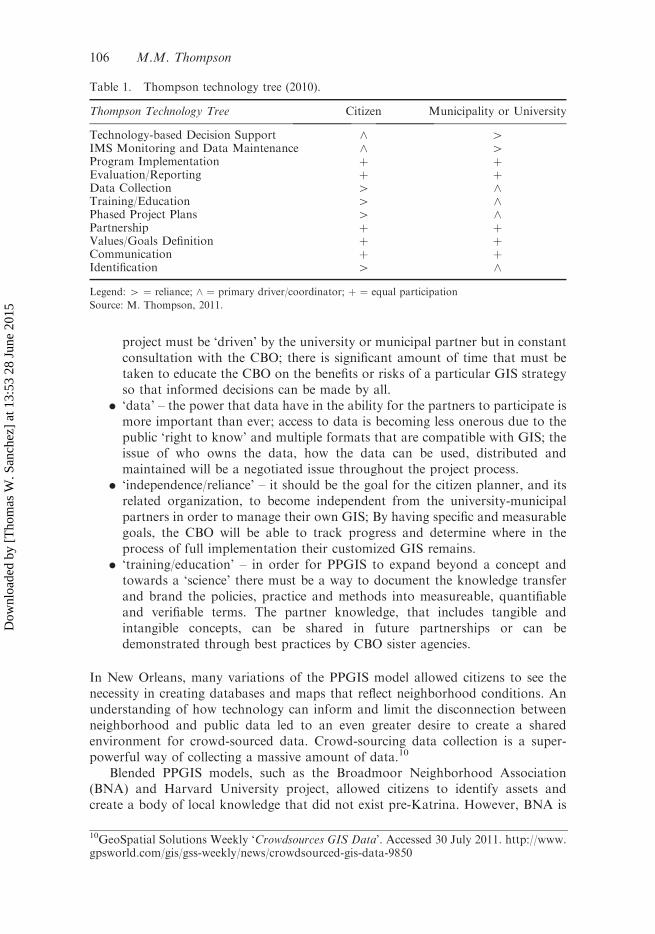
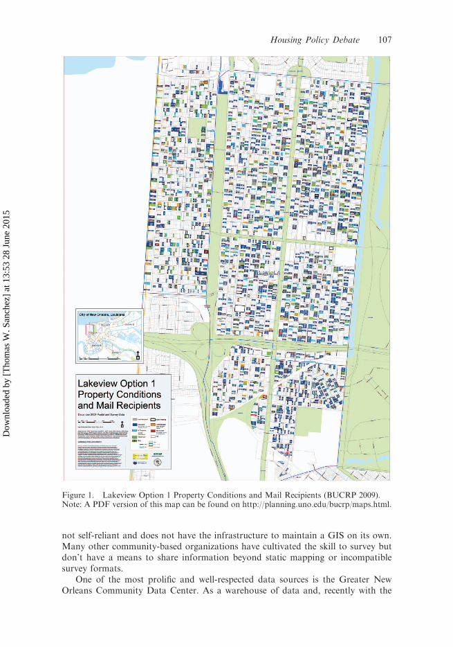
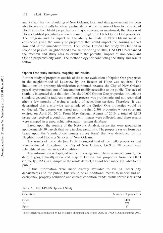
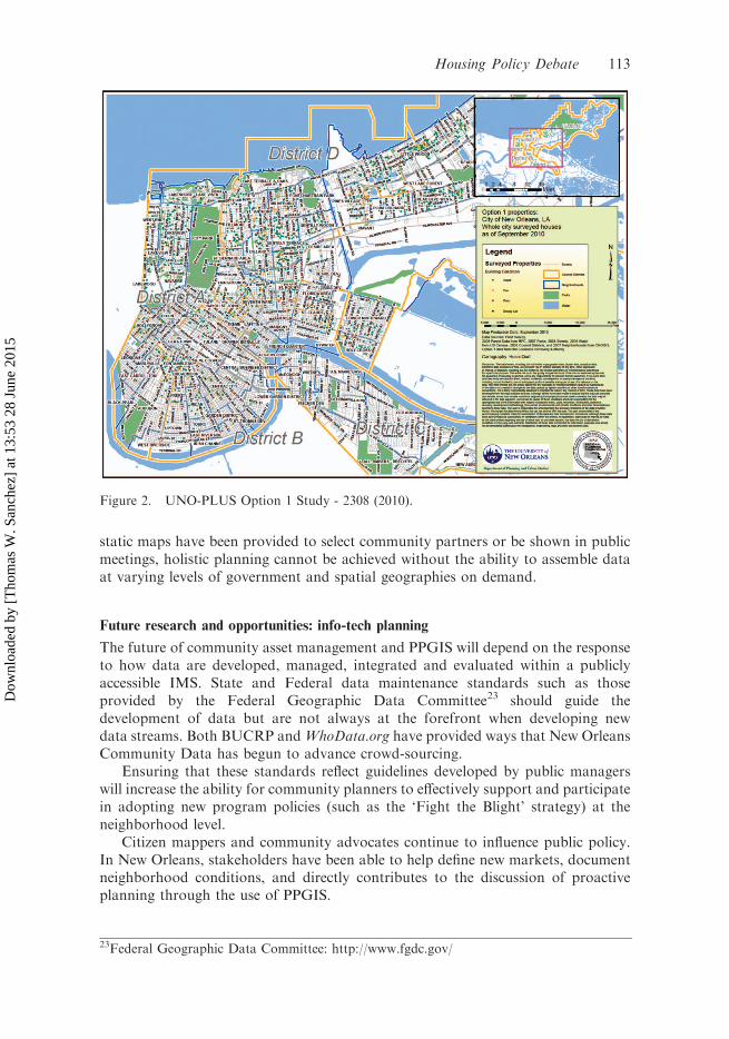