the coastview project: developing video-derived coastal state indicators in support of coastal zone...
TRANSCRIPT
(2007) 463–475www.elsevier.com/locate/coastaleng
Coastal Engineering 54
The CoastView project: Developing video-derived Coastal StateIndicators in support of coastal zone management
Mark Davidson a,⁎, Mark Van Koningsveld b, Arno de Kruif c, Jane Rawson d, Rob Holman e,Alberto Lamberti f, Raul Medina g, Aart Kroon h, Stefan Aarninkhof b
a School of Earth Ocean and Environmental Science, University of Plymouth, Drake Circus, Plymouth, Devon, PL4 8AA, UKb WL | Delft Hydraulics, P.O. Box 177, 2600 MH Delft, Netherlands and Delft University of Technology, Delft, The Netherlands
c Rijkswaterstaat, National Institute for Coastal and Marine Management- RIKZ P.O.Box 20907, 2500 EX Den Haag, The Netherlandsd UK Environment Agency, Kingfisher House, Goldhay Way, Orton Goldhay, UK
e Oceanic/Atmospheric Sciences, Oregon State University, 104 COAS Administration Bldg, Corvallis, OR 97331-5503, USAf University of Bologna, DISTART Idraulica, Viale Risorgimento, 2, 40136 Bologna, Italy
g University of Cantabria, Av Los Castros s/n, 39005 Santander, Cantabria, Spainh University of Copenhagen, Øster Voldgade 10, 1350 København K, Denmark
Available online 21 March 2007
Abstract
This contribution outlines the philosophy and procedures adopted in a major European research project focused on the development of videosystems in support of coastal zone management. The CoastView project has developed video-derived Coastal State Indicators (CSIs) that directlyfacilitate management decisions. Coastal State Indicators are defined here as, “A reduced set of issue-related parameters that can simply,adequately and quantitatively describe the dynamic-state and evolutionary trends of a coastal system”. The process of defining useful CSIsinvolves close interaction between coastal managers, scientists and policy makers. Even with frequent formal discussions and colloquia betweenthese parties the process of defining useful indicators frequently fails. An approach [Van Koningsveld, M., 2003. Matching specialist knowledgewith end-user needs. PhD Thesis, University of Twente, Enschede, The Netherlands, 173 p.] is described in this paper which guarantees theeffectiveness of the resulting CSIs, and enhances the communication process between scientist and coastal managers. Some practical examples ofthe frame of reference are given by way of illustration and a detailed description is given of the procedure adopted within the CoastView projectfor defining and evaluating CSIs. The philosophies and methodologies used during the three year CoastView project have proved successful andprovide a valuable template on which to base future research projects focussing on end-user oriented research.© 2007 Elsevier B.V. All rights reserved.
Keywords: Coast; Coastal State Indicators; CSIs; Video system; Management; Argus; Frame of reference; Navigation; Coastal protection; Recreation; Coastal policy;Prediction; Managers; Scientists; Communication
1. Introduction
This contribution has the dual aims of a) describing asuccessful methodology for developing tools for coastal monitor-ing and management which are of potential value to futureresearch projects and b) providing background information for,and an introduction to, key papers emanating from this researchprocess.
⁎ Corresponding author. Tel.: +44 1752 232450; fax: +44 1752 232406.E-mail address: [email protected] (M. Davidson).
0378-3839/$ - see front matter © 2007 Elsevier B.V. All rights reserved.doi:10.1016/j.coastaleng.2007.01.007
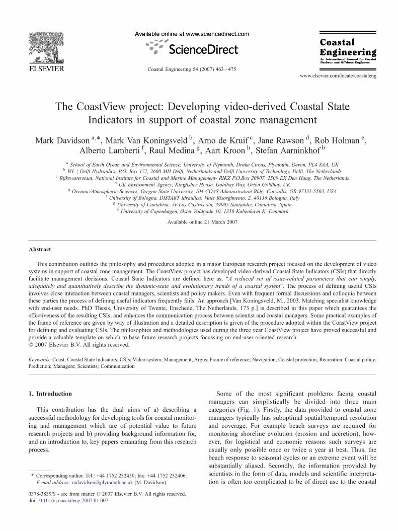
Some of the most significant problems facing coastalmanagers can simplistically be divided into three maincategories (Fig. 1). Firstly, the data provided to coastal zonemanagers typically has suboptimal spatial/temporal resolutionand coverage. For example beach surveys are required formonitoring shoreline evolution (erosion and accretion); how-ever, for logistical and economic reasons such surveys areusually only possible once or twice a year at best. Thus, thebeach response to seasonal cycles or an extreme event will besubstantially aliased. Secondly, the information provided byscientists in the form of data, models and scientific interpreta-tion is often too complicated to be of direct use to the coastal
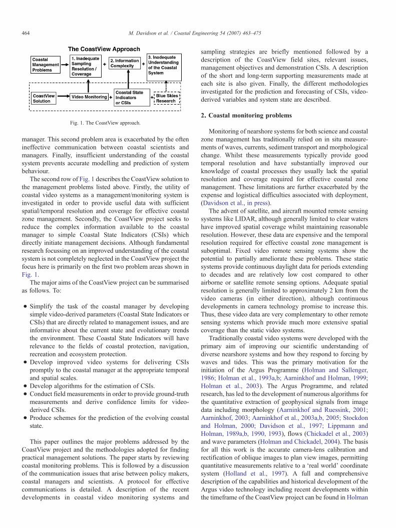
Fig. 1. The CoastView approach.
464 M. Davidson et al. / Coastal Engineering 54 (2007) 463–475
manager. This second problem area is exacerbated by the oftenineffective communication between coastal scientists andmanagers. Finally, insufficient understanding of the coastalsystem prevents accurate modelling and prediction of systembehaviour.
The second row of Fig. 1 describes the CoastView solution tothe management problems listed above. Firstly, the utility ofcoastal video systems as a management/monitoring system isinvestigated in order to provide useful data with sufficientspatial/temporal resolution and coverage for effective coastalzone management. Secondly, the CoastView project seeks toreduce the complex information available to the coastalmanager to simple Coastal State Indicators (CSIs) whichdirectly initiate management decisions. Although fundamentalresearch focussing on an improved understanding of the coastalsystem is not completely neglected in the CoastView project thefocus here is primarily on the first two problem areas shown inFig. 1.
The major aims of the CoastView project can be summarisedas follows. To:
• Simplify the task of the coastal manager by developingsimple video-derived parameters (Coastal State Indicators orCSIs) that are directly related to management issues, and areinformative about the current state and evolutionary trendsthe environment. These Coastal State Indicators will haverelevance to the fields of coastal protection, navigation,recreation and ecosystem protection.
• Develop improved video systems for delivering CSIspromptly to the coastal manager at the appropriate temporaland spatial scales.
• Develop algorithms for the estimation of CSIs.• Conduct field measurements in order to provide ground-truthmeasurements and derive confidence limits for video-derived CSIs.
• Produce schemes for the prediction of the evolving coastalstate.
This paper outlines the major problems addressed by theCoastView project and the methodologies adopted for findingpractical management solutions. The paper starts by reviewingcoastal monitoring problems. This is followed by a discussionof the communication issues that arise between policy makers,coastal managers and scientists. A protocol for effectivecommunications is detailed. A description of the recentdevelopments in coastal video monitoring systems and
sampling strategies are briefly mentioned followed by adescription of the CoastView field sites, relevant issues,management objectives and demonstration CSIs. A descriptionof the short and long-term supporting measurements made ateach site is also given. Finally, the different methodologiesinvestigated for the prediction and forecasting of CSIs, video-derived variables and system state are described.
2. Coastal monitoring problems
Monitoring of nearshore systems for both science and coastalzone management has traditionally relied on in situ measure-ments of waves, currents, sediment transport and morphologicalchange. Whilst these measurements typically provide goodtemporal resolution and have substantially improved ourknowledge of coastal processes they usually lack the spatialresolution and coverage required for effective coastal zonemanagement. These limitations are further exacerbated by theexpense and logistical difficulties associated with deployment,(Davidson et al., in press).
The advent of satellite, and aircraft mounted remote sensingsystems like LIDAR, although generally limited to clear watershave improved spatial coverage whilst maintaining reasonableresolution. However, these data are expensive and the temporalresolution required for effective coastal zone management issuboptimal. Fixed video remote sensing systems show thepotential to partially ameliorate these problems. These staticsystems provide continuous daylight data for periods extendingto decades and are relatively low cost compared to otherairborne or satellite remote sensing options. Adequate spatialresolution is generally limited to approximately 2 km from thevideo cameras (in either direction), although continuousdevelopments in camera technology promise to increase this.Thus, these video data are very complementary to other remotesensing systems which provide much more extensive spatialcoverage than the static video systems.
Traditionally coastal video systems were developed with theprimary aim of improving our scientific understanding ofdiverse nearshore systems and how they respond to forcing bywaves and tides. This was the primary motivation for theinitiation of the Argus Programme (Holman and Sallenger,1986; Holman et al., 1993a,b; Aarninkhof and Holman, 1999;Holman et al., 2003). The Argus Programme, and relatedresearch, has led to the development of numerous algorithms forthe quantitative extraction of geophysical signals from imagedata including morphology (Aarninkhof and Ruessink, 2001;Aarninkhof, 2003; Aarninkhof et al., 2003a,b, 2005; Stockdonand Holman, 2000; Davidson et al., 1997; Lippmann andHolman, 1989a,b, 1990, 1993), flows (Chickadel et al., 2003)and wave parameters (Holman and Chickadel, 2004). The basisfor all this work is the accurate camera-lens calibration andrectification of oblique images to plan view images, permittingquantitative measurements relative to a ‘real world’ coordinatesystem (Holland et al., 1997). A full and comprehensivedescription of the capabilities and historical development of theArgus video technology including recent developments withinthe timeframe of the CoastView project can be found in Holman
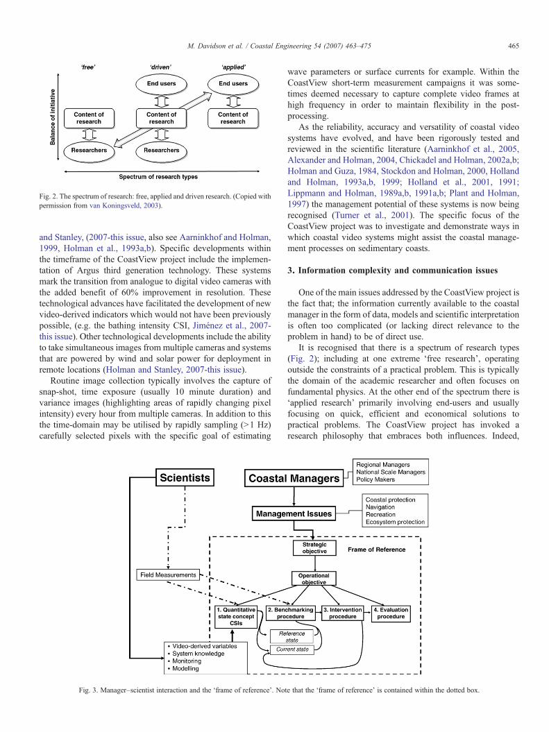
Fig. 2. The spectrum of research: free, applied and driven research. (Copied withpermission from van Koningsveld, 2003).
465M. Davidson et al. / Coastal Engineering 54 (2007) 463–475
and Stanley, (2007-this issue, also see Aarninkhof and Holman,1999, Holman et al., 1993a,b). Specific developments withinthe timeframe of the CoastView project include the implemen-tation of Argus third generation technology. These systemsmark the transition from analogue to digital video cameras withthe added benefit of 60% improvement in resolution. Thesetechnological advances have facilitated the development of newvideo-derived indicators which would not have been previouslypossible, (e.g. the bathing intensity CSI, Jiménez et al., 2007-this issue). Other technological developments include the abilityto take simultaneous images from multiple cameras and systemsthat are powered by wind and solar power for deployment inremote locations (Holman and Stanley, 2007-this issue).
Routine image collection typically involves the capture ofsnap-shot, time exposure (usually 10 minute duration) andvariance images (highlighting areas of rapidly changing pixelintensity) every hour from multiple cameras. In addition to thisthe time-domain may be utilised by rapidly sampling (>1 Hz)carefully selected pixels with the specific goal of estimating
Fig. 3. Manager–scientist interaction and the ‘frame of reference’. Not
wave parameters or surface currents for example. Within theCoastView short-term measurement campaigns it was some-times deemed necessary to capture complete video frames athigh frequency in order to maintain flexibility in the post-processing.
As the reliability, accuracy and versatility of coastal videosystems have evolved, and have been rigorously tested andreviewed in the scientific literature (Aarninkhof et al., 2005,Alexander and Holman, 2004, Chickadel and Holman, 2002a,b;Holman and Guza, 1984, Stockdon and Holman, 2000, Hollandand Holman, 1993a,b, 1999; Holland et al., 2001, 1991;Lippmann and Holman, 1989a,b, 1991a,b; Plant and Holman,1997) the management potential of these systems is now beingrecognised (Turner et al., 2001). The specific focus of theCoastView project was to investigate and demonstrate ways inwhich coastal video systems might assist the coastal manage-ment processes on sedimentary coasts.
3. Information complexity and communication issues
One of the main issues addressed by the CoastView project isthe fact that; the information currently available to the coastalmanager in the form of data, models and scientific interpretationis often too complicated (or lacking direct relevance to theproblem in hand) to be of direct use.
It is recognised that there is a spectrum of research types(Fig. 2); including at one extreme ‘free research’, operatingoutside the constraints of a practical problem. This is typicallythe domain of the academic researcher and often focuses onfundamental physics. At the other end of the spectrum there is‘applied research’ primarily involving end-users and usuallyfocusing on quick, efficient and economical solutions topractical problems. The CoastView project has invoked aresearch philosophy that embraces both influences. Indeed,
e that the ‘frame of reference’ is contained within the dotted box.

Fig. 4. Outline map showing the location of the CoastView field sites.
466 M. Davidson et al. / Coastal Engineering 54 (2007) 463–475
many outcome-focussed research projects (e.g. the EuropeanFramework projects) occupy this middle ground, buildingconsortia that include scientists, end-users managers and policymakers. However, even given this commendable approachhistory has demonstrated that useful management outcomes arenot guaranteed. A major source of problems is related to poor orineffective communication between scientists, coastal zonemanagers and policy makers. On one hand, scientists are of theopinion that their knowledge is not effectively implemented andthat end-users are reluctant to embrace new ideas in place oftried and tested methods, whilst end-users of specialist knowl-edge often claim that research findings cannot, or cannot easily,be put to practical use.
Many of these communication problems arise due to thedivergent pressures on scientists and end-users. Scientists areunder pressure to publish their findings in top academic journalsrequiring a strong novelty element to their research. Coastalmanagers by comparison are intent in solving the most pressingpractical problems at hand. Timescales are also an issue; formanagers these urgent and often very serious problems requirequick solutions, whilst scientists are at liberty to explore morefundamental research with the promise of long-term benefits.
Consortia including scientists, managers, policy makers andpotentially other stake holders provide ideal colloquia to tacklepractical management problems. However, these divergentpressures and approaches often lead to much ‘uncontrolled’ andunproductive discussion (Van Koningsveld et al., 2005). A rigidframework for discussion is required which defines clearly therole of both managers and end-users. Such a framework isdescribed in this contribution (Fig. 3).
Fig. 3 demonstrates the important contributions of twogroups; the scientists on the top left-hand side of the diagramand coastal managers on the right. The CoastView project seeksresults that are of both site specific and generic value. Thereforeit is necessary to actively include not only regional managers
who are primarily concerned with the immediate, localproblems but also national scale bodies and policy makers;for example, the UK Environment Agency and the DutchRykswaterstaat. The overall aim is to seek a better match ofspecialist knowledge to end-user needs.
The first stage of the process is for coast managers to defineclearly the management issues they face and the currentmechanisms in place for dealing with these problems. A keyproblem which emerged through the course of the CoastViewproject was the difference between what coastal managers andscientists respectively considered to be implicit knowledgerelating to a particular issue. Therefore considerable discussionwas needed in order to reveal this implicit knowledge.
Generally, within the CoastView project it was found thatissues could be grouped under the following four headings;coastal protection, recreation, navigation and ecosystemprotection. Here discussions proceed under these headingswhilst it is acknowledged that coastal management problemscover a much wider scope than those considered here includingcompeting land-uses (e.g. recreation vs. residential or con-servation vs. development), fisheries and resource managementto mention a few. Not all of these issue categories are easilyassisted using video-derived indicators.
From the discussions that followed it was clear that policy,monitoring and management processes vary significantly acrossdifferent European states. A positive by-product of thesediscussions was the obvious enthusiasm of the coastal managersinvolved to learn from their European counterparts and to sharebest practice.
The issues resulting from these discussions were then rankedin two ways. Firstly, issues were ranked in order of importance,(from the coastal manager's perspective). Secondly, since it isclear that coastal video systems cannot assist in all managementareas, an assessment was made as to whether or not thetechnology is likely to provide a viable means of addressing theproblem. Issues that rank highly on both scales are consideredas viable demonstration CSIs for the CoastView project.
Having defined the current issues and management practicesthe ‘frame of reference’ is invoked (van Konigsveld, 2004). InFig. 3 the frame of reference is defined within the dashed box.The starting point is the strategic objective which defines thelong-term management vision for the environment (i.e. what isrequired, long term?). A good example taken from theNetherlands called the ‘Dynamic Preservation Policy’ asdefined by the Dutch Government is; “…to guarantee asustainable safety level and a sustainable preservation of valuesand user functions of the dune area…,” (Ministry of PublicWorks and Water Management, 1990).
The strategic objective is satisfied by one or a number ofoperational objectives; which define what will be done in theshort term to satisfy part of, or the entire strategic objective.Taking the same example for the Dutch coastline, it is knownthat the user function and value of the coast was intact in 1990.Therefore an appropriate strategic objective for the Dutchcoastline is; “… the coastline will be maintained at its position inthe year 1990…,” (Ministry of Public Works and WaterManagement, 1990).

467M. Davidson et al. / Coastal Engineering 54 (2007) 463–475
This is where the scientists come in, proposing models, data,and most importantly for the CoastView project video-derivedvariables which might assist the monitoring and managementprocess.
The strategic objective is achieved in a four stage process.This starts with the Coastal State Indicators (CSI). Here CSIsare defined as: “A reduced set of issue-related parameters thatcan simply, adequately and quantitatively describe the dynamic-state and evolutionary trends of a coastal system”, (Davidsonet al., in press). In more simple terms a CSI is a parameter thatdirectly facilitates a management decision. These CSIs mayalso draw upon video-derived variables, model predictions andother data sources. Sometimes simple video-derived variablesprovide adequate CSIs on their own. Other problems demandthe aggregation of additional data sources or perhaps modeloutput.
CSIs are compared to benchmark values, (stage 2). If thebenchmark value is exceeded a predefined interventionprocedure is initiated (stage 3). Finally, the success of theprocess is assessed through an evaluation procedure (stage 4),
Fig. 5. a) A panoramic view of Teigmouth, UK from five digitally merged Argus camdata shown in (a) above. All images are 10 minute time-averages. Notice how the higthe submerged shoals.
which determines whether the strategic and operationalobjectives are being met. If the evaluation procedure is notsatisfactory then the operational and/or the strategic objective(s)may require modification as shown by the feedback loops inFig. 3.
To continue the example for the Dutch coast the relevant CSIwould be the current shoreline position. This shoreline positionrequires rigorous definition and is usually expressed in terms ofthe momentary coastline (MCL, Ministry of Public Works andWater Management, 1991). The MCL reflects the volume ofsand contained in a meter wide section of the coast betweenpredefined vertical limits, and it is measured relative to a fixedhorizontal datum. A testing coastline (TCL) is defined by linearforward extrapolation of the previous 10 years of MCLestimates (stage 1). The resulting TCL is compared to a 1990benchmark value called the basal coastline (BCL) which isestimated in precisely the same manner (i.e. it is the 1990 TCL).If the shoreline position is projected to be landward of the 1990position using this methodology (stage 2) a shoreface nourish-ment scheme is initiated (stage 3). The subsequent evaluation
eras (recorded 16 December, 2001). b) A rectified plan-view image of the imageh intensity parts of the image which represent frequent wave breaking illuminate
468 M. Davidson et al. / Coastal Engineering 54 (2007) 463–475
procedure would assess whether or not the 1990 shorelineposition is successfully maintained alongside the value and userfunction of the coast.
The communication problems between scientists, managersand policy makers are well recognised e.g. “The bridge betweenscientists and policy maker is weak, if indeed there is a bridge atall”, (quote from the European Commission, Director Generalfor the Environment at the European Land Ocean Interaction(ELOISE) Conference, Portoroz, Slovenia, 2004). The frame ofreference approach described here provides an effective bridgebetween scientists, managers and policy makers. Notice that theindicators (CSIs) that are defined here are distinct from someother indicators mentioned in the scientific literature; bydefinition the indicator must directly facilitate a managementprocess. If this essential condition is not met then the termvariable is applied in place of indicator. The focal point of thebridge is the CSI; however the process also encapsulates therelevant science, management problems and policy. Mostimportantly a rigid framework for discussion results from thisprocedure that assists controlled, productive dialogue betweenall parties.
4. CoastView field sites, issues, management objectives anddemonstration CSIs
Management decisions often have far reaching ecological,financial and safety implications. This fact often leads toreluctance to embrace new, unproven methodologies. It isessential that all parties have confidence in the monitoring andmanagement process and it is necessary therefore to rigorouslytest any new process in order to firmly evaluate its accuracy and
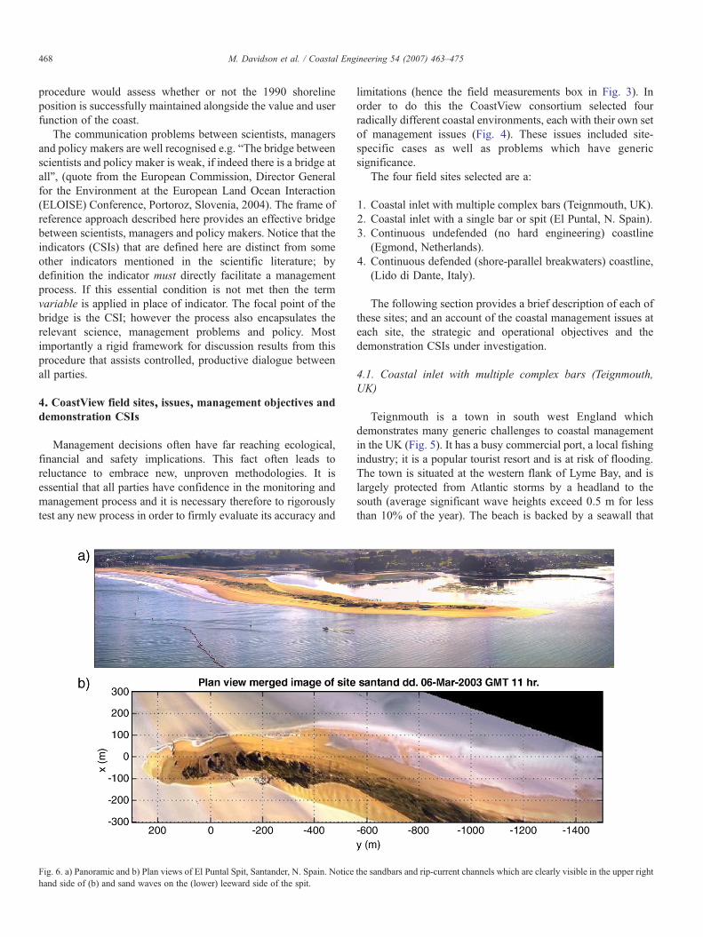
Fig. 6. a) Panoramic and b) Plan views of El Puntal Spit, Santander, N. Spain. Noticehand side of (b) and sand waves on the (lower) leeward side of the spit.
limitations (hence the field measurements box in Fig. 3). Inorder to do this the CoastView consortium selected fourradically different coastal environments, each with their own setof management issues (Fig. 4). These issues included site-specific cases as well as problems which have genericsignificance.
The four field sites selected are a:
1. Coastal inlet with multiple complex bars (Teignmouth, UK).2. Coastal inlet with a single bar or spit (El Puntal, N. Spain).3. Continuous undefended (no hard engineering) coastline
(Egmond, Netherlands).4. Continuous defended (shore-parallel breakwaters) coastline,
(Lido di Dante, Italy).
The following section provides a brief description of each ofthese sites; and an account of the coastal management issues ateach site, the strategic and operational objectives and thedemonstration CSIs under investigation.
4.1. Coastal inlet with multiple complex bars (Teignmouth,UK)
Teignmouth is a town in south west England whichdemonstrates many generic challenges to coastal managementin the UK (Fig. 5). It has a busy commercial port, a local fishingindustry; it is a popular tourist resort and is at risk of flooding.The town is situated at the western flank of Lyme Bay, and islargely protected from Atlantic storms by a headland to thesouth (average significant wave heights exceed 0.5 m for lessthan 10% of the year). The beach is backed by a seawall that
the sandbars and rip-current channels which are clearly visible in the upper right

469M. Davidson et al. / Coastal Engineering 54 (2007) 463–475
both supports a main railway line, and protects the town fromerosion and flooding. A private company owns the harbour, andtherefore has joint responsibility with the local port authority forthe management of the mouth of the estuary and the adjacentcoastline. The mouth of the estuary is bordered by a dynamicsystem of highly mobile sandbanks (Fig. 5) which have a majorcontrol over the sediment distribution within the coastal system,and pose a significant hazard to shipping. Additionally, bathersoccasionally become ‘cut-off’ and stranded on the offshorebanks during the rising tide. The evolution of the coastalsandbanks at Teignmouth has been observed to follow a distinctcyclic pattern with a period of approximately 5–7 years(Robinson, 1975). Video observations made within the Coast-View project indicate that the cycle may be significantly quickerthan this often taking less than 2 years. The beach and itsrecreational function fall under the jurisdiction of the localcouncil. Teignmouth is a macrotidal environment (tidalrange=1.2 to 4.5 m) with strong tidal flows (up to 2.0 m/s)that pose a significant risk to both recreational users of the beachand shipping.
Three specific strategic objectives for Teignmouth that arerelated to a sub-set of those detailed in the Department ofEnvironment, Food and Rural Affair's (DEFRA's- http://www.defra.gov.uk/) shoreline management plans for the site are asfollows:
1. To protect the developed areas of Teignmouth from flooding.2. To maintain safe navigational access to the port of
Teignmouth.
Fig. 7. a) A panoramic view of Egmond, Netherlands from four digitally merged Argudata shown in (a) above. All images are 10 minute time-averages. Notice how the higthe submerged sandbars.
3. To maintain the safety, area and water quality of the bathingbeach.
The specific operational objectives pertaining to the Teign-mouth site that were addressed during the CoastView project arerelated primarily to the latter two strategic objectives (the firstbeing adequately addressed at Egmond), and were as follows:
a) To ensure that the dynamic navigation channel and hazardsare adequately marked.
b) To ensure that effective dredging operations are employedunder all conditions.
c) To promote public awareness of bathing hazards, dangerareas and safe bathing zones.
Strategic objective ‘a’ was addressed by implementing anautomated means of monitoring the location of the channelmarker buoys in relation to the rapidly evolving sandbankmorphology. Full details of this procedure are given in Medinaet al. (2007-this issue). The CSI in this instance is the sandbank–buoy inter-distance or SBID. A reduction of the SBID below acritical threshold value is designed to initiate a managementintervention involving the repositioning of the buoy.
The second operational objective ‘b’ was addressed byvideo-monitoring the spatial distribution of dredging intensityby automatically tracking dredging operations in the channel.The intensity of the dredging effort was assessed in relation tothe morphodynamic response which was also measured by thevideo system. The goal here was to evaluate the most effective
s cameras, (recorded 31 May, 1999). b) A rectified plan-view image of the imageh intensity parts of the image which represent frequent wave breaking illuminate
470 M. Davidson et al. / Coastal Engineering 54 (2007) 463–475
dredging strategy for each of the systems distinct morphody-namic states.
The third operational objective, relating to bather safety, alsoinvolves a morphodynamic classification of the estuary into anumber of frequently identified morphological states thatcharacterise phases of the cyclic evolution of the sandbars inthe outer estuary and beach. Each beach state is associated withdifferent spatial distribution in bathing hazards. These bathinghazards include areas where bathers can be ‘cut-off’ onsandbanks during the rising tide and strong tide- and wave-driven flows than run vigorously between the banks. Hydro-dynamic models were run in order to identify particularlyhazardous regions and rectified video images were used toconstruct simple schematic diagrams illustrating the potentialmorphological states of the system. The most recent videoimage allows lifeguards to identify the current state of thesystem. The current image of the system is publicly displayedalongside the appropriate schematic diagram showing bathersclearly where it is, and is not, safe to bathe (Jiménez et al., 2007-this issue).
The resulting CSIs and frames of reference relating to thesestrategic and operation objectives are discussed in detail in
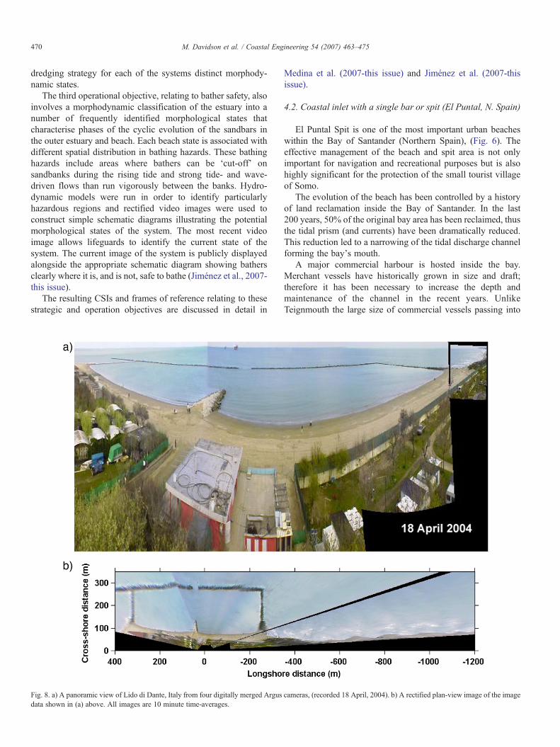
Fig. 8. a) A panoramic view of Lido di Dante, Italy from four digitally merged Argusdata shown in (a) above. All images are 10 minute time-averages.
Medina et al. (2007-this issue) and Jiménez et al. (2007-thisissue).
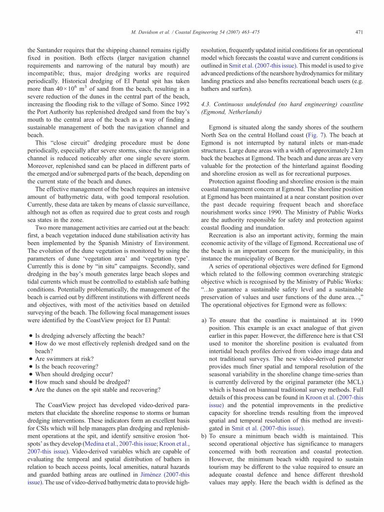
4.2. Coastal inlet with a single bar or spit (El Puntal, N. Spain)
El Puntal Spit is one of the most important urban beacheswithin the Bay of Santander (Northern Spain), (Fig. 6). Theeffective management of the beach and spit area is not onlyimportant for navigation and recreational purposes but is alsohighly significant for the protection of the small tourist villageof Somo.
The evolution of the beach has been controlled by a historyof land reclamation inside the Bay of Santander. In the last200 years, 50% of the original bay area has been reclaimed, thusthe tidal prism (and currents) have been dramatically reduced.This reduction led to a narrowing of the tidal discharge channelforming the bay's mouth.
A major commercial harbour is hosted inside the bay.Merchant vessels have historically grown in size and draft;therefore it has been necessary to increase the depth andmaintenance of the channel in the recent years. UnlikeTeignmouth the large size of commercial vessels passing into
cameras, (recorded 18 April, 2004). b) A rectified plan-view image of the image
471M. Davidson et al. / Coastal Engineering 54 (2007) 463–475
the Santander requires that the shipping channel remains rigidlyfixed in position. Both effects (larger navigation channelrequirements and narrowing of the natural bay mouth) areincompatible; thus, major dredging works are requiredperiodically. Historical dredging of El Puntal spit has takenmore than 40×106 m3 of sand from the beach, resulting in asevere reduction of the dunes in the central part of the beach,increasing the flooding risk to the village of Somo. Since 1992the Port Authority has replenished dredged sand from the bay'smouth to the central area of the beach as a way of finding asustainable management of both the navigation channel andbeach.
This “close circuit” dredging procedure must be doneperiodically, especially after severe storms, since the navigationchannel is reduced noticeably after one single severe storm.Moreover, replenished sand can be placed in different parts ofthe emerged and/or submerged parts of the beach, depending onthe current state of the beach and dunes.
The effective management of the beach requires an intensiveamount of bathymetric data, with good temporal resolution.Currently, these data are taken by means of classic surveillance,although not as often as required due to great costs and roughsea states in the zone.
Two more management activities are carried out at the beach:first, a beach vegetation induced dune stabilisation activity hasbeen implemented by the Spanish Ministry of Environment.The evolution of the dune vegetation is monitored by using theparameters of dune ‘vegetation area’ and ‘vegetation type’.Currently this is done by “in situ” campaigns. Secondly, sanddredging in the bay's mouth generates large beach slopes andtidal currents which must be controlled to establish safe bathingconditions. Potentially problematically, the management of thebeach is carried out by different institutions with different needsand objectives, with most of the activities based on detailedsurveying of the beach. The following focal management issueswere identified by the CoastView project for El Puntal:
• Is dredging adversely affecting the beach?• How do we most effectively replenish dredged sand on thebeach?
• Are swimmers at risk?• Is the beach recovering?• When should dredging occur?• How much sand should be dredged?• Are the dunes on the spit stable and recovering?
The CoastView project has developed video-derived para-meters that elucidate the shoreline response to storms or humandredging interventions. These indicators form an excellent basisfor CSIs which will help managers plan dredging and replenish-ment operations at the spit, and identify sensitive erosion ‘hot-spots’ as they develop (Medina et al., 2007-this issue;Kroon et al.,2007-this issue). Video-derived variables which are capable ofevaluating the temporal and spatial distribution of bathers inrelation to beach access points, local amenities, natural hazardsand guarded bathing areas are outlined in Jiménez (2007-thisissue). The use of video-derived bathymetric data to provide high-
resolution, frequently updated initial conditions for an operationalmodel which forecasts the coastal wave and current conditions isoutlined in Smit et al. (2007-this issue). This model is used to giveadvanced predictions of the nearshore hydrodynamics for militarylanding practices and also benefits recreational beach users (e.g.bathers and surfers).
4.3. Continuous undefended (no hard engineering) coastline(Egmond, Netherlands)
Egmond is situated along the sandy shores of the southernNorth Sea on the central Holland coast (Fig. 7). The beach atEgmond is not interrupted by natural inlets or man-madestructures. Large dune areas with a width of approximately 2 kmback the beaches at Egmond. The beach and dune areas are veryvaluable for the protection of the hinterland against floodingand shoreline erosion as well as for recreational purposes.
Protection against flooding and shoreline erosion is the maincoastal management concern at Egmond. The shoreline positionat Egmond has been maintained at a near constant position overthe past decade requiring frequent beach and shorefacenourishment works since 1990. The Ministry of Public Worksare the authority responsible for safety and protection againstcoastal flooding and inundation.
Recreation is also an important activity, forming the maineconomic activity of the village of Egmond. Recreational use ofthe beach is an important concern for the municipality, in thisinstance the municipality of Bergen.
A series of operational objectives were defined for Egmondwhich related to the following common overarching strategicobjective which is recognised by the Ministry of Public Works:“…to guarantee a sustainable safety level and a sustainablepreservation of values and user functions of the dune area…,”The operational objectives for Egmond were as follows:
a) To ensure that the coastline is maintained at its 1990position. This example is an exact analogue of that givenearlier in this paper. However, the difference here is that CSIused to monitor the shoreline position is evaluated fromintertidal beach profiles derived from video image data andnot traditional surveys. The new video-derived parameterprovides much finer spatial and temporal resolution of theseasonal variability in the shoreline change time-series thanis currently delivered by the original parameter (the MCL)which is based on biannual traditional survey methods. Fulldetails of this process can be found in Kroon et al. (2007-thisissue) and the potential improvements in the predictivecapacity for shoreline trends resulting from the improvedspatial and temporal resolution of this method are investi-gated in Smit et al. (2007-this issue).
b) To ensure a minimum beach width is maintained. Thissecond operational objective has significance to managersconcerned with both recreation and coastal protection.However, the minimum beach width required to sustaintourism may be different to the value required to ensure anadequate coastal defence and hence different thresholdvalues may apply. Here the beach width is defined as the

472 M. Davidson et al. / Coastal Engineering 54 (2007) 463–475
intertidal distance measured from the low-tide position onthat day to the dune foot. If the beach width CSI falls below athreshold value the intervention procedure of shoreface/beach nourishment is invoked.
c) To build no seasonal property (e.g. beach restaurants)seawards of the 5% high-tide exceedence line. In thisexample a statistical analysis of a year of (video-derived)high-tide shoreline positions was carried out for the area ofcoast covered by the Argus cameras. From this analysis a 5%exceedence contour was overlaid on a rectified Argus image.Building seaward of this contour is deemed to be unsafeduring the summer season.
d) To promote public awareness of bathing hazards, dangerareas and safe bathing zones. This strategic objective is thesame as the one stated for the Teignmouth site. However, thenature of the bathing hazards is different and generally takesthe form of strong longshore or rip-currents. Video-derivedvariable which define the strength and position of thelongshore/rip-currents are discussed in Jiménez et al. (2007-this issue).
4.4. Continuous defended coastline, (Lido di Dante, Italy)
Lido di Dante is a resort located on the Adriatic, Emilia-Romagna coast, 7 km from Ravenna, Italy (Fig. 8). The sandybeach of Lido di Dante is positioned between the Fiumi river-mouth to the north and the Bevano river-mouth to the south. Thearea covered by the video system includes both a stretch ofnatural coastline as well as region defended by a 770 m longsemi-submerged breakwater and three rock groins. The use ofthe beach for tourism, together with its serious erosion problemswhich started in the 1970s makes this an ideal site for coastalengineering, geomorphology and management studies. Thelocal tidal excursion in this area is low (±0.4 m at spring tide)with exceptional tides reaching 1 m above mean sea level. Thewave climate is generally mild, dominated by steep fetchlimited waves generated by the NE Bora winds and longerScirocco generated waves from the SE. Average significantwave heights and periods are approximately 0.5 m and 4 srespectively, and extreme storm events can produce waves of upto 6 m significant wave height and 10 s period.
Local erosion problems were significantly exacerbated in the1960s by subsidence resulting due to the extraction of methaneproducing ground water. Although the extraction processes wereprohibited in 1982 in this area coastal protection from erosion andinundation remains a key coastal management problem. The beachis also an important resource for recreation which at a regionallevel provides one of the major sources of income for the area.Beach width, measured from toe of the head defences or dune foot(whichever is present) to the mean water level is a simple effectiveCSI for this area. Minimum beach levels required to sustaintourism have been estimated at 20mwith an optimum target valueof 50 m (Lamberti, 2002). Water quality degradation by harmfulalgal blooms and eutrophication resulting from restricted ventila-tion in the leeward areas of coastal structures is also an issue at thissite although no obvious means of assisting coastal managers withcoastal video systems has yet been established.
The number and distribution of beach umbrellas was foundto be an excellent video-derived variable for evaluating theintensity and spatial distribution of beach users at Lido di Dante,(Jiménez et al., 2007-this issue). Hazards to bathers at Lido diDante fall into two distinct categories depending on thepresence or absence of structures. In the defended regionwave-driven currents interact with the structures giving rise tostrong flows that are hazardous to swimmers. Jiménez et al.(2007-this issue) demonstrate how video systems can be used toinvestigate the strength and structure of these flows. In theundefended beach zone bathing hazards take the form of rip-currents which can also be located using the time-averagedvideo images.
Three primary management contexts were investigated bythe CoastView project including, coastal protection (Kroonet al., 2007-this issue); navigation (Medina et al., 2007-thisissue) and recreational safety/beach use (Jiménez et al., 2007-this issue).
5. Long-term and short-term measurements
Specific long-term measurements are required for theeffective implementation of video monitoring for both scienceand management. Of primary importance are the supplementarymeasurements of tidal height and incident wave statistics. Thisinformation is of particular importance for the accuraterectification of oblique video images and the estimation of theshoreline location. These data were recorded at each site for theduration of the video measurements. Since one of the majorstrengths of the video systems under investigation was theestimation of the evolving coastal morphology, long-termmeasurements included regular topographic and bathymetricsurveys which provided an essential source of ground-truthdata.
The short-term measurement campaigns (typically up to amonth in duration) were designed specifically to provide ground-truth measurements for the prioritised demonstration CSIs underinvestigation and therefore varied slightly from site to site. Theaim here was to establish the accuracy of the video-derived CSIsand variables and where possible to establish confidence limits.These measurements included: manual, quad-bike and boat basedGPS surveys of topography and bathymetry, sometimes focusingon the shoreline position and navigation marker positions,offshore and inshore measurements of wave spectra (pressuretransducers and acoustic Doppler current profilers, ADCPs),surface and subsurface flows (electromagnetic current meters andADCPs), sediment suspension (optical backscatter sensors) andtransport.
6. Prediction
The aim here was to establish whether the high-frequencyoften long-term video measurements which exhibit good spatialcoverage and resolution can provide a level of predictability thatcannot yet be achieved using other data sources and modellingmethods. In particular; do long time-series of video-derivedparameters enhance our understanding of the system they
473M. Davidson et al. / Coastal Engineering 54 (2007) 463–475
describe and/or facilitate extrapolation forward in time? Threeaspects of prediction supported by video data are investigatedby Smit et al. (2007-this issue):
• Data-driven modelling/extrapolation. This methodologyseeks coherent trends and patterns in the video-derivedtime-series of variables and CSIs that might providepredictability, either with or without additional informationon the relevant forcing. Methodologies like simple extra-polation, neural networks and the Holt–Winter's methodwere tested.
• Video data feeding into models. In this context Argusprovides initial/boundary conditions and/or calibration datafor a variety of different model types, including processbased models, semi-empirical and empirical models.
• Data model integration. This intermediary between the firsttwo methodologies outlined above and refers to the closecoupling between video data and a detailed process model.Typically, the approach is used to tune free time dependent freemodel parameters and is most appropriate for non-linearfeedback dominated systems. A good example of this is thesubtidal beach mapper algorithm that evaluates bathymetry byintegrating video time-averaged images with a process modelyielding wave energy dissipation (Aarninkhof et al., 2005).Wave dissipation is a function of the underlying bathymetry,wave characteristics and tidal level. Time-averaged imagesprovide an estimate of the intensity and spatial distribution ofwave energy dissipation which can be inverted using theprocess model to yield bathymetric estimates. Other examplesinclude the application of Dynamic Neural Networks. Thereader is referred to Smit et al. (2007-this issue) for full detailsof these modelling approaches.
7. Concluding Remarks
The use of coastal video systems for scientific research iswell documented in the scientific literature. This contributiondetails the methodologies developed within a Europeanresearch, demonstration and technology project designed toexplore and evaluate the practical utility of these systems forcoastal zone monitoring and management. The CoastViewproject was designed to develop video-derived Coastal StateIndicators. These are simple parameters which are designed totrigger a specific management intervention, should thresholdvalues be exceeded. The project has combined scientists, andnational and regional coastal zone managers to complete thetask of defining appropriate Coastal State Indicators.
As a focus for the study four very different field sites wereselected, each with their own distinct (but globally relevant)management issues. Strategic and operational objectives andrelating CSIs have been defined for each site. The sites havebeen described in this contribution, focusing on pressingmanagement problems, in order to set the scene for subsequentpapers in this special issue.
The project has successfully developed a protocol foreffective communication between scientists, coastal zonemanagers and policy makers. The frame of reference procedure
(Fig. 3; Van Koningsveld, 2003) was instrumental in directingcontrolled, focused and productive discussions between scien-tists and managers in a search for effective Coastal StateIndicators. The frame of reference procedure advocated by theCoastView project ensures that CSIs are directly and obviouslylinked to specific management issues. Furthermore, the frame ofreference ensures that a predefined management interventionand assessment procedure is initiated if CSIs exceed predefinedthreshold values. The frame of reference is a generic method-ology that is by nomeans restricted to video-derived CSIs, indeedit effectively facilitates the combination of video with other datasources, model output and specialist knowledge.
This paper has also highlighted the importance of thoroughtesting and validating Coastal State Indicators using focused fieldmeasurement campaigns for the evaluation of appropriateconfidence limits. Management decisions often have far reachingecological, financial and safety implications. This fact often leadsto reluctance to embrace new, unproven methodologies. It isessential therefore that all parties (scientists, managers, stake-holders and policymakers) have confidence in themonitoring andmanagement process, and it is necessary therefore to rigorouslytest any new process in order to firmly establish its accuracy andlimitations.
Demonstration CSIs have been identified in the contexts ofcoastal protection (Kroon et al., 2007-this issue), recreation(Jiménez et al., 2007-this issue) and navigation (Medina et al.,2007-this issue). The frame of reference procedure outlined inthis contribution is implemented in these related papers.
During the timeframe of the CoastView project there havebeen considerable advances in the digital video technologyallowing more effective sampling strategies, with higher resolu-tion (Holman and Stanley 2007-this issue). The unique nature ofthe video data in terms of its high-frequency, long-term samplingpotential combined with good spatial resolution and coverage,opens new possibilities for the prediction of coastal evolution.Smit et al. (2007-this issue) investigate the use of video-deriveddata as boundary conditions to numerical process models, data-driven modelling approaches and combined video-model inversemodelling approaches.
Finally, it is essential that the coastal state information isdelivered to coastal managers efficiently, at the appropriatefrequency and in format that directly assists managementdecisions. A mechanism for delivering video-derived coastalstate information to the managers via a simple, easy to use, web-based interface is discussed in detail in Turner and Anderson(2007-this issue). The CoastView approach, the key outputs ofthe project and the future of coastal management video systemsare critically reviewed in VanKoningsveld et al., 2007-this issue.
Acknowledgements
The authors would like to thank the European Commission forsupporting the CoastView project under the Fifth FrameworkResearch and Technical Development Action, (project reference:EVK3-CT-2001-0054). The authors would also like to thank theCoastView consortium for their valuable contributions to thisproject including: Andres Osario, Carlo Albertazzi, C. Mauro,
474 M. Davidson et al. / Coastal Engineering 54 (2007) 463–475
David Huntley, David Marcano, D. Anderson, Francesca Ribas,Gerben Ruessink, Howard Southgate, Irene van Enkevort, IrvElshoff, Ismael Marino-Tapia, John Stanley, Jose Jimenez, JulieRichards, Justin Ridgewell, Katalina Wijnberg, Ken Kingston,Marcel Stive, L. Boak, Marie-Louise Soendberg, Martin Blok,Marije Aarninkhof, M. Cerroni, Mauricio Gonzalez, MollerSorensen, Niels Vinther, Nigel Aird, Paolo Ciavola, Paco Martin,Peter Ganderton, Rutger Wierda, Ruud Spanhoff, Silvia Medri,Suzan Quartel, S. Andersen, Troels Aagaard, V. Garcia, the wholeArgus consortium and all other kind contributors to the Coast-View project. Finally, but not least, we highly appreciate thecomments of the referees of this paper which significantlyimproved the final draft.
References
Aarninkhof, S.G.J., 2003. Nearshore bathymetry derived from video imagery.PhD Thesis, Delft University of Technology, the Netherlands, 165 p.
Aarninkhof, S.G.J., Holman, R.A., 1999. Monitoring the nearshore with video.Backscatter 10 (2), 8–11.
Aarninkhof, S.G.J., Ruessink, B.G., 2001. Video Observations of WaveBreaking and the Implications for Wave Decay Modelling. Proc. CoastalDynamics '01. New York, ASCE, pp. 979–988.
Aarninkhof, S.G.J., Turner, I.L., Dronkers, T.D.T., Caljouw, M., 2003a. Avideo-based technique for mapping intertidal beach bathymetry. CoastalEngineering 49 (4), 275–289.
Aarninkhof, S.G.J., Ruessink, B.G., Roelvink, J.A., de Kruif, A.C., 2003b.Quantification of Surfzone Bathymetry from Video Observations of WaveBreaking. Proc. Coastal Sediments Conf., Florida, USA.
Aarninkhof, S.G.J., Ruessink, B.G., Roelvink, J.A., 2005. Nearshore subtidalbathymetry from time-exposure video images. Journal of GeophysicalResearch 110 (C6) (Art. No. C06011 JUN 23 2005).
Alexander, P.S., Holman, R.A., 2004. Quantitative analysis of nearshoremorphological variability based on video imaging. Marine Geology 208(1), 101–111.
Chickadel, C., Holman, R.A., 2002a. Measuring longshore currents with videotechniques. EOS Trans. AGU, 82(47). Fall Meet. Suppl.
Chickadel, C., Holman, R.A., 2002b. Optical measurements of low frequencycross-shore flows. EOS Trans. AGU, 83(47), p. F717. Fall Meet. Suppl.
Chickadel, C.C., Holman, R.A., Freilich, M.F., 2003. An optical technique forthe measurement of longshore currents. Journal of Geophysical Research108 (C11), 3364.
Davidson, M.A., Huntley, D.A., Holman, R.A., George, K., K.R., 1997. TheEvaluation of Large-scale (km) Intertidal Beach Morphology on aMacrotidal Beach using Video Images. Proceedings Coastal Dynamics '97.ASCE, pp. 385–394.
Davidson,M.A., Aarninkhof, S.G.J., VanKoningsveld,M., Holman, R.A., in press.Developing Coastal Video Monitoring Systems in support of Coastal ZoneManagement. Journal of Coastal Research. SI 39. ICS 2004. (Proceedings)Brazil 0749-0208.
Holland, K.T., Holman, R.A., 1993a. The statistical distribution of swashmaxima on natural beaches. Journal of Geophysical Research 98 (C6),10,271–10,278.
Holland, K.T., Holman, R.A., 1993b. A Stereometric Technique for MappingForeshore Topography. EOSTransactions. AmericanGeophysical Union, p. 338.
Holland, K.T., Holman, R.A., 1999. Wavenumber–frequency structure ofinfragravity swash motions. Journal of Geophysical Research 104 (C6),13479–13488.
Holland, K.T, Holman, R.A., Lippmann, T.C., Stanley, J., Plant, N., 1997.Practical use of video imagery in nearshore oceanographic field studies.IEEE Journal of Oceanic Engineering 22 (1), 81–92 (special issue on imageprocessing for oceanic applications).
Holland, K.T., Puleo, J.A., Kooney, T.N., 2001. Quantification of swash flowsusing video-based particle image velocimetry. Coastal Engineering 44, 65–77.
Holman, R.A., Chickadel, C.C., 2004. Optical Remote Sensing Estimates of theIncident Wave Angle Field During NCEX. 29th International Conference onCoastal Engineering. ASCE, Lisbon.
Holman, R.A., Guza, R.T., 1984. Measuring run-up on a natural beach. CoastalEngineering 8, 129–140.
Holman, R.A., Sallenger Jr., R.H., 1986. High-energy nearshore processes.Transactions of American Geophysics Union (Eos) 67 (49), 1369–1371.
Holman, R.A., Stanley, J., 2007. The History and Technical Capabilities ofArgus. Coastal Engineering 54, 477–491 (this issue). doi:10.1016/j.coastaleng.2007.01.003.
Holman, R.A., Lippmann, T.C., O'neill, P.V., Hathaway, K., 1991. Videoestimation of subaerial beach profiles. Marine Geology 97, 225–231.
Holman, R.A., Sallenger, J.A.H., Lippmann, T.C., Haines, J.W., 1993a. Theapplication of video image processing to the study of nearshore processes.Oceanography 6 (3), 78–85.
Holman, R.A., Sallenger, A.H.J., Lippmann, T.C., Haines, J.W., 1993b. Thepractical application of video image processing to the study of nearshoreprocesses. Oceanography 6 (3), 78–85.
Holman, R.A., Stanley, J., Özkan-Haller, T.H., 2003. Applying video sensornetworks to nearshore environmental monitoring. IEEE Pervasive Computing2 (4), 14–21.
Jiménez, J.A., Osorio, A., Marino-Tapia, I., Davidson, M., Medina, R., Kroon, A.,Archetti, R., Ciavola, P., Aarnikhof, S.G.J., 2007. Beach recreation planningusing video-derivedCoastal State Indicators. Coastal Engineering 54, 507–521(this issue). doi:10.1016/j.coastaleng.2007.01.012.
Kroon, A., Davidson, M.A., Aarninkhof, S.G.J., Archetti, R., Armaroli, C.,Gonzalez, M., Medri, S., Osorio, A., Aagaard, T., Holman, R.A.,Spanhoff, R., 2007. Application of remote sensing video systems to coastlinemanagement problems. Coastal Engineering 54, 493–505 (this issue).doi:10.1016/j.coastaleng.2007.01.004.
Lamberti, A., 2002. A Brief Overview of Coastal Management Problems at Lidodi Dante. Initial report on Coastal State Indicators (CSIs). Official report ofthe CoastView Project. available from: www.TheCoastViewProject.org.
Lippmann, T.C., Holman, R.A., 1989a. Quantification of sand bar morphology:a video technique based on wave dissipation. Journal of GeophysicalResearch 94 (C1), 995–1011.
Lippmann, T.C., Holman, R.A., 1989b. Quantification of sand bar morphology:a video technique based on wave dissipation. Journal of GeophysicalResearch 94 (C1), 995–1011.
Lippmann, T.C., Holman, R.A., 1990. The spatial and temporal variability ofsand bar morphology. Journal of Geophysical Research 95 (C7),11,575–11,590.
Lippmann, T.C., Holman, R.A., 1991a. Phase speed and angle of breakingwaves measured with video techniques. Proceedings of Coastal Sediments'91, pp. 489–497.
Lippmann, T.C., Holman, R.A., 1991b. Phase speed and angle of breakingwaves measured with video techniques. In: Kraus, N. (Ed.), CoastalSediments, '91. ASCE, New York, pp. 542–556.
Lippmann, T.C., Holman, R.A., 1993. Episodic, non-stationary behaviour of adouble bar system at Duck, North Carolina, USA, 1986–1991. Journal ofCoastal Research 49–75 (Special Issue No. 15).
Medina, R., Marino-Tapia, I., Osorio, A., Davidson, M., Martin, F.L., 2007.Management of dynamic navigational channels using video techniques. CoastalEngineering 54, 523–537 (this issue). doi:10.1016/j.coastaleng.2007.01.008.
Ministry for Transport and Public Works, 1990. Coastal Defence after 1990, APolicy Choice for Coastal Protection. 1st Coastal Policy Document, Ministryof Transport, Public Works and Water Management. The Hague, NL.
Ministry for Transport and Public Works, 1991. De basiskustlijn, een technisch/morphologische uitwerking. Technical Report of the Document, Ministry ofTransport, Public Works and Water Management. In Dutch.
Plant, N.G., holman, R.A., 1997. Intertidal beach profile estimation using videoimages. Marine Geology 140, 1–24.
Robinson, A.H.W., 1975. Cyclic Changes in Shoreline Development at theentrance to Teignmouth Harbour, Devon, England. In: Hails, J., Carr, A.(Eds.), Nearshore Sediment Dynamics and Sedimentation. John Wiley,London, pp. 181–194.
Smit, M.W.J., Aarninkhof, S.G.J., Wijnberg, K.M., González, M., Kingston, K.S.,Southgate, H.N., Ruessink, B.G., Holman, R.A., Siegle, E., Davidson, M.,

475M. Davidson et al. / Coastal Engineering 54 (2007) 463–475
Medina, R., 2007. The role of video imagery in predicting daily to monthlycoastal evolution. Coastal Engineering 54, 539–553 (this issue). doi:10.1016/j.coastaleng.2007.01.009.
Stockdon, H.F., Holman, R.A., 2000. Estimation of wave phase speed andnearshore bathymetry from video imagery. Journal of Geophysical Research105 (C9), 22,015–22,033.
Turner, I.L., Dronkers, T., Aarninkhof, S., Mcgrath, J., 2001. The Application ofVideo Imaging to Quantify Beach Response to Sand Nourishment andConstruction of an Artificial Reef. 15th Australasian Coastal and OceanEngineering Conference, IEA, Gold Coast, pp. 55–60.
Turner, I.L., Anderson, D.J., 2007. Web-based and ‘Real-time’Beach Management System. Coastal Engineering 54, 555–565 (this issue).doi:10.1016/j.coastaleng.2007.01.002.
Van Koningsveld, M., 2003.Matching specialist knowledgewith end user needs.PhD Thesis, University of Twente, Enschede, The Netherlands, 173 p.
Van Koningsveld, M., Davidson, M.A., Huntley, D.A., 2005. Matching sciencewith coastal management needs; The search for appropriate Coastal StateIndicators. Journal of Coastal Research 21 (3), 399–411.
Van Koningsveld, M., Davidson, M.A., Huntley, D.A., Medina, R.,Aarninkhof, S., Jiménez, J.A., Ridgewell, J., de Kruif, A., 2007. A criticalreview of the Coast View Project: recent and future developments incoastal management video systems. Coastal Engineering 54, 567–576(this issue). doi:10.1016/j.coastaleng.2007.01.006.