the death coral caver - mexican cave s death coral caver no.3 october 1993 editors mack pitchford,...
TRANSCRIPT


THE DEATH CORAL CAVERNo.3 October 1993
Editors
Mack Pitchford, Peter Sprouse
PRODUCTION
Susie Lasko
OFFICERS
President: Peter SprouseBoard of Directors: John Fogarty, Susie Lasko,
David McKenzie, Dale Pate
Proyecto Espeleol6gico Purificaci6nP.O. Box 8424
Austin, Texas 78713 USA
The Death Coral Caver is published by the ProyectoEspeleol6gico Purificaci6n, a non-profit organizationincorporated in the State of Texas. The PEP is dedicated to the study and exploration of the caves andkarst of the Purificaci6n Karst Area in the states ofNuevo Le6n and Tamaulipas, Mexico. Articles fromthe Death Coral Caver may be reprinted in othernot-for-profit publications with proper attribution.Any material relating to the Purificaci6n Karst Area iswelcomed for publication. Membership in the PEP isavailable to interested individuals who share theproject's goals of careful caving. Annual dues are$15 per year for individuals. Corporate or institutionalmemberships are $100 for a 5-year term. Memberswill receive newsletters as they are published, andmay vote in elections of the Board of Directors.
PHOTO CREDITS
Front Cover - Charley Savvas and Bill Stephens lightup part of the immense Cardassian Borehole.1993 photo by Peter Sprouse.
Inside Front - Noel Sloan gives the MK4 rebreather afinal check before Jim Brown's dive in the LeftHand Sump. 1993 Photo by Bill Stone.
Back Cover - John Stembel does a socks-only rappelinto the Road to Nowhere, flashed by GregMcNamara. 1993 Photo by Peter Sprouse.
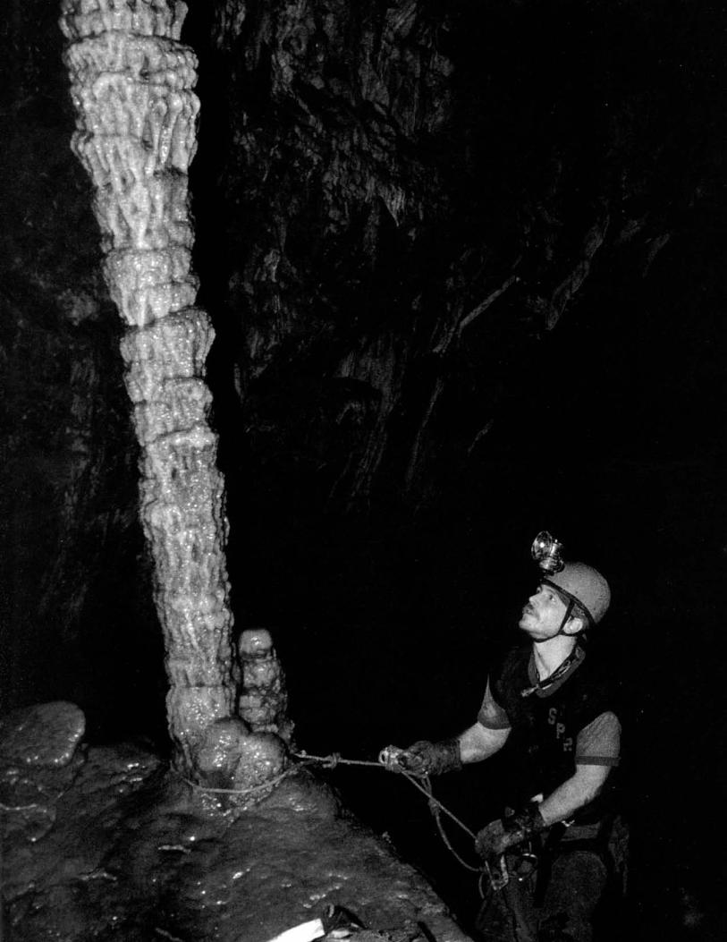
Inside Back Cover - Joe Oliphant on Farpoint climb.1993 Photo by Peter Sprouse.
EDITORIAL
Speleology: the study of caves. That is how it isusually defined. Yet it is not just another "ology". Thespeleologist, or caver, has a peculiar passion, somewould say obsession, you likely wouldn't see in say,a radiologist. It is, for the most part, not a profession,but an avocation: you don't graduate from a universitywith a degree in speleology. Certainly a biology orgeology degree may be cave-related, but speleology isreally a grass-roots science generated by cavers goingcaving. Cave research isn't so confined by the needsof commerce, it develops in an individualistic, yetorderly manner, not unlike caves themselves.
The PEP is frolicking in a grand adventure inspeleology. We have in our laps a wonderful karstarea with 20 years of caving tradition behind it. Pieceby piece, we are building a detailed model of a hugemountain range and the labyrinth of tunnels whichpierce it.
Peter Sprouse
CONTENTS
1993 Tecolote Expedition 2Invertebrate Fauna of Cueva del Tecolote 8Paradise Revisited 10Purificaci6n Area Cave Descriptions 15Underwater Exploration in Sistema Purificaci6n 22Trip Reports. . . . . . . . . . . . . . . . . . . . . . .. 26
PURIFICACION~KARST AREA
ACKNOWLEDGEMENTS
The PEP would like to thank the following corporate sponsors for contributions during 1993:
Margaret Cullinan Wray Charitable TrustDogwood City GrottoHitachi Power Tools USAPigeon Mountain IndustriesAzon Corporation (K&E Field books)Sokkia Corporation (Lietz tapes)Mont-bell AmericaOregon Freeze DrySuunto USA
1993 TECOLOTE EXPEDITIONby Peter Sprouse
'\.
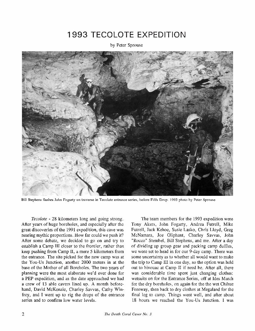
Bill Stephens flashes John Fogarty on traverse in Tecolote entrance series, before Fifth Drop. 1993 photo by Peter Sprouse
Teeolote - 28 kilometers long and going strong.After years of huge boreholes, and especially after thegreat discoveries of the 1991 expedition, this cave wasnearing mythic proportions. How far could we push it?After some debate, we decided to go on and try toestablish a Camp III closer to the frontier, rather thankeep pushing from Camp II, a mere 5 kilometers fromthe entrance. The site picked for the new camp was atthe You-Us Junction, another 2000 meters in at thebase of the Mother of all Boreholes. The two years ofplanning were the most elaborate we'd ever done fora PEP expedition, and as the date approached we hada crew of 13 able cavers lined up. A month beforehand, David McKenzie, Charley Savvas, Cathy Winfrey, and I went up to rig the drops of the entranceseries and to confirm low water levels.
The team members for the 1993 expedition wereTony Akers, John Fogarty, Andrea Futrell, MikeFutrell, Jack Kehoe, Susie Lasko, Chris Lloyd, GregMcNamara, Joe Oliphant, Charley Savvas, John"Rocco" Stembel, Bill Stephens, and me. After a dayof dividing up group gear and packing camp duffles,we were set to head in for our 9-day camp. There wassome uncertainty as to whether all would want to makethe trip to Camp III in one day, so the option was heldout to bivouac at Camp II if need be. After all, therewas considerable time spent just changing clothes:wetsuits on for the Entrance Series, off at Ides Marchfor the dry boreholes, on again for the the wet ChihueFreeway, then back to dry clothes at Megaland for thefinal leg to camp. Things went well, and after about18 hours we reached the You-Us Junction. I was
2 The Death Coral Caver No. 3
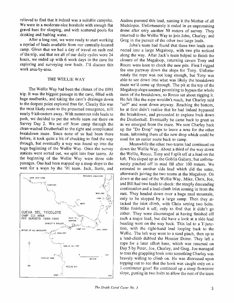
THE WELLIE WAY
Andrea pursued this lead, naming it the Mother of allMudslopes. Unfortunately it ended in an unpromisingdome after only another 50 meters of survey. Theyreturned to the Wellie Way to join John, Charley, andGreg in the pursuit of the other two large leads.
John's team had found that these two leads connected into a large Megaloop, with two pits noticedalong the way. After Jack's team helped to finish theclosure of the Megaloop, returning cavers Tony andRocco were keen to check the new pits. First I riggedthe one partway down the slope for Tony. Unfortunately the rope was not long enough, but Tony wasable to see down into what was likely the breakdownmaze we'd come up through. The pit at the top of theMegaloop slope seemed promising to bypass the wholemess of the breakdown, so Rocco set about rigging it.He felt like the rope wouldn't reach, but Charley said"so?" and went down anyway. Reaching the bottom,he at first didn't realize that he had indeed bypassedthe breakdown, and proceeded to explore back downthe Drutherhall. Eventually he came back to greet usas we emerged from the maze. We sent Charley backup the "Do Drop" rope to leave a note for the otherteam, informing them of the new drop which could beused for an easier route back to camp.
Meanwhile the other two teams had continued ondown the Wellie Way. About a third of the way downthe Wellie, Rocco, Tony and I split off at a lead on theleft. This sloped up as the Goblin Gallery, but unfortunately pinched off in mud fill after 100 meters. Weretreated to another side lead which did the same,afterwards joining the two teams at the Megaloop. Ondown at the end,ofthe Wellie Way, Mike, Chris, Joe,and Bill had two leads to check: the steeply descendingcontinuation and a lead-climb inlet coming in from theeast. They headed down over a huge mud mountain,only to be stopped by a large sump. Then they attacked the inlet climb, with Chris setting two bolts.Mike finished it off, only to find that it didn't goeither. They were discouraged at having finished offsuch a major lead, but did have a look at a side leadheading west on the way back. This led to a T-junction, with the right-hand lead looping back to theWellie. The left way went to a sand pinch, then up toa lead-climb dubbed the Hoosier Dome. They left arope for a later effort here, which was resumed onDay 5 by Peter, Joe, Charley, and Greg. Joe managedto toss the grappling hook onto something Charley wasbravely willing to climb on. He was distressed upontopping out to see that the hook was caught only on aI-centimeter gour! He continued up a steep flowstoneslope, putting in two bolts to allow the rest of the team
P55
500
LAVA LAKES
METERS
RESEARCH BOULEVARD~
1-.
(~~~~~
CAMP II @
~- PROADTO~ 1NOWt1ERE I P -"-<\
'b
FAAPOINT
~\ GOBLIN GALLERY
~HOOSIER OO"E '1~
\"
! WELLlE WAY
)
SUNP ~
Nm
J.lEGALOOP
CHARLEY'S CHILLER
oeEP CAVE NINE
IoKlTHER OF ALL MUOSlOPES
CUEVA DEL TECOLOTECAMP III AREAPEP SURVEYS 1989-1993
relieved to find that it indeed was a suitable campsite.We were in a moderate-size borehole with enough flatgravel bars for sleeping, and with scattered pools fordrinking and bathing water.
After a long rest, we were ready to start workinga myriad of leads available from our centrally-locatedcamp. Given that we had a day of travel on each endof the trip, and that not all of our daily cycles were 24hours, we ended up with 6 work days in the cave forexploring and surveying new leads. I'll discuss thiswork area-by-area.
The Wellie Way had been the climax of the 1991trip. It was the biggest passage in the cave, filled withhuge mudbanks, and taking the cave's drainage downto the deepest point explored thus far. Clearly this wasthe most likely route to the presumed resurgence, stillnearly 9 kilometers away. With numerous side leads topush, we decided to put the whole team out there onSurvey Day 2. We set off from camp through theclean-washed Drutherhall to the tight and complicatedbreakdown maze. Since none of us had been therebefore, it took quite a bit of checking to find the waythrough, but eventually a way was found up into thehuge beginning of the Wellie Way. Once the surveystations were sorted out, we split into four teams. Atthe beginning of the Wellie Way were three sidepassages. One had been mapped up a steep slope to thewest for a ways by the '91 team. Jack, Susie, and
The Death Coral Caver No. 3 3

a
CUEVA DEL TECOLOTETAMAULIPAS, MEXICO
DEEP CAVE NINE ENTRANCE
SURVEYS 1980-1993 BYPROYECTO ESPELEOLOGICO PURIFICACIONCAVEVIEW LINE PLOT BY PETER SPROUSE
LENGTH:32,031 METERS DEPTH:424 METERSPROFILE:50° VIEW
100
CARDASSIAN BOREHOLE200
100
400 METERS
~==5:::- BAT ROOM
LAVA lAKES
MILLENIUM
FALCON
SUMP
to survey up. At the top, they found a complex boneyard maze which eventually pinched with no way on.
Backtracking up the Drutherhall on Day 2, alarge side lead was checked not too far below camp.This soon split, with the left way ending in a largeroom. The right way soon became wet, and the surveystopped at an overhung climb out of a lake. This"Charley's Chiller" was the object of a return trip onDay 5, but Charley was unable to get enough heightwith the grappling hook.
CAMP AREA LEADS
Charley and Mike had better luck with the hookin the Grandmother Borehole above camp on Day 1.They accessed a high ledge to a large room, andfollowed a slope up to a hands-and-knees crawl. Thisswung left to an area of nice aragonite bushes, Grandma's Cookies. A lead on the left went to a pit whichpresumably led down to another known pit lead off theGrandmother Borehole. They went to look at that leadbut could not find a rig point on the mudslope. So theyretreated to another side lead which resulted in a loopback into the Grandmother.
Another lead quite close to camp was the eastpassage from the You-Us Junction, Paul's Plunge.With Rocco declaring "we don't need no stinkingwetsuits", he, Mike, Susie, and John set off to map762 meters in 117 stations on Day 3. They were inand out of the water in dark, eroded flowstone, whichearned it the name Lava Lakes. They were headingupstream toward a possible connection with the ThroneRoom area near Camp II, but skinny Mike found thewater a bit cold without his wetsuit. Towards the endof the survey, it was splitting up and getting complicated, but kept on going.
Not far from camp were several leads in theDeath Coral Borehole, which goes west off of the
Mother of all Boreholes. The second left-hand passageof the DCB was a great-looking lead-climb. Chrisstarted work on it on Day 1, placing several runnersand a bolt. Rocco then took his place and topped outon a muddy slope. Greg and I followed with thesurvey up to a short formation gallery. Here was adrop down into what I suspected would be the firstleft-hand passage off of the DCB called Road toNowhere. I backtracked around to the Road to Nowhere and, sure enough, I could hear the others through a hole visible at the top of a spectacular stripedflowstone cascade (back cover). Rocco and Gregcompleted the loop by rappelling barefoot, so as not tomuddy up the stal. Farther along the Death CoralBorehole was another lead-climb which Greg had a goat on Day 4, essentially a steep mud slope. As he cutsteps in the mud, he slipped and started an uncontrolled slide. When he tried to self-arrest with hisplastic trowel, it broke in two, but it did slow himdown, keeping his injuries to a scraped arm. Thisbecame known as the Trowel and Error. The next dayJohn managed to finish this climb, but it merelydropped right back down to the DCB.
A more promising lead was the water hole. Wehad found this in 1991, a small tube off the right sideof the DCB containing the only water in the wholearea, where we were filling our canteens. I hadsqueezed past the pool for about 30 meters, and itcontinued with airflow. So on Day 3, Jack, Joe, Tony,and Greg ended up pushing it as an alternate lead.Naming the crawlway "Pay Your Dues", they kept atit until it opened up. This new section was reasonablylarge and rather complex, a series of flowstone rooms.After several hundred meters it seemed worth comingback to the next day. Now named Mars, the arearesulted in another 200 meters of survey beforerunning dry.
4 The Death Coral Caver No. 3
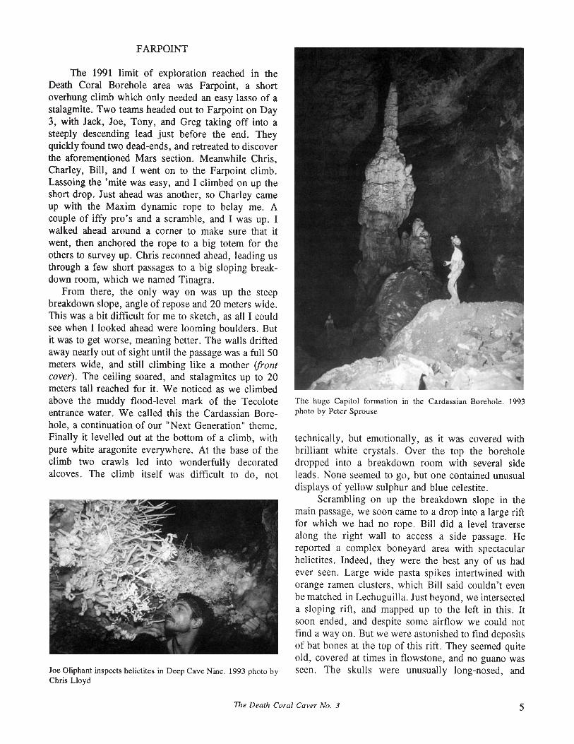
FARPOINT
The 1991 limit of exploration reached in theDeath Coral Borehole area was Farpoint, a shortoverhung climb which only needed an easy lasso of astalagmite. Two teams headed out to Farpoint on Day3, with Jack, Joe, Tony, and Greg taking off into asteeply descending lead just before the end. Theyquickly found two dead-ends, and retreated to discoverthe aforementioned Mars section. Meanwhile Chris,Charley, Bill, and I went on to the Farpoint climb.Lassoing the 'mite was easy, and I climbed on up theshort drop. Just ahead was another, so Charley cameup with the Maxim dynamic rope to belay me. Acouple of iffy pro's and a scramble, and I was up. Iwalked ahead around a corner to make sure that itwent, then anchored the rope to a big totem for theothers to survey up. Chris reconned ahead, leading usthrough a few short passages to a big sloping breakdown room, which we named Tinagra.
From there, the only way on was up the steepbreakdown slope, angle of repose and 20 meters wide.This was a bit difficult for me to sketch, as all I couldsee when I looked ahead were looming boulders. Butit was to get worse, meaning better. The walls driftedaway nearly out of sight until the passage was a full 50meters wide, and still climbing like a mother (frontcover). The ceiling soared, and stalagmites up to 20meters tall reached for it. We noticed as we climbedabove the muddy flood-level mark of the Tecoloteentrance water. We called this the Cardassian Borehole, a continuation of our "Next Generation" theme.Finally it levelled out at the bottom of a climb, withpure white aragonite everywhere. At the base of theclimb two crawls led into wonderfully decoratedalcoves. The climb itself was difficult to do, not
Joe Oliphant inspects helictites in Deep Cave Nine. 1993 photo byChris Lloyd
The huge Capitol fonnation in the Cardassian Borehole. 1993photo by Peter Sprouse
technically, but emotionally, as it was covered withbrilliant white crystals. Over the top the boreholedropped into a breakdown room with several sideleads. None seemed to go, but one contained unusualdisplays of yellow sulphur and blue celestite.
Scrambling on up the breakdown slope in themain passage, we soon came to a drop into a large riftfor which we had no rope. Bill did a level traversealong the right wall to access a side passage. Hereported a complex boneyard area with spectacularhelictites. Indeed, they were the best any of us hadever seen. Large wide pasta spikes intertwined withorange ramen clusters, which Bill said couldn't evenbe matched in Lechuguilla. Just beyond, we intersecteda sloping rift, and mapped up to the left in this. Itsoon ended, and despite some airflow we could notfind a way on. But we were astonished to find depositsof bat bones at the top of this rift. They seemed quiteold, covered at times in flowstone, and no guano wasseen. The skulls were unusually long-nosed, and
The Death Coral Caver No. 3 5

though filled with clay tended to crumble whentouched. This discovery, over 8 kilometers from theTecolote entrance, naturally set off speculation regarding a second, perhaps paleo entrance. Later plotting ofthe data showed that we had climbed almost up to thelevel of the Tecolote entrance, and that the CardassianBorehole was ascending under the east slope of theMesas Jul1rez with 180 meters of overburden. But nowit was time to leave, with some team members gettinga bit dehydrated from the long climb, having left thelast water some 1500 meters back. Fortunately wefound a nice pool below the aragonite climb, guardedby a cluster of distinctive stalagmites which we namedthe Cardassians.
On Day 4, Mike, Charley, and Rocco returned tothe Cardassian with rope to drop into the rift, whichbeing a bit loose earned the name Rift Van Tinkle. Itcontinued up to an apparent end after about 100meters. Charley attempted a freeclimb at the back, buta foothold gave way, sending him to the floor with afew scrapes. Next he used the grappling hook, whichgot him up, only to find that his lead pinched. Although this ended our exploration of the CardassianBorehole, it stands as the largest and most well-decorated section of Tecolote. And the mysterious batbones will likely inspire a new search on the surfacefor a possible second entrance. One final trip on Day6 was made by Chris and Joe to photograph thehelictite area, now named Deep Cave Nine.
Bat skull found in Deep Cave Nine. (to scale)
CAMP II AREA
As the expedition wound to a close, it wasdecided to move back to Camp II for the last day topush a lead at the end of Research Boulevard. Thiswas a promising lead-climb which we had worked onDay 4. John, Joe, Bill, and I had returned to the pointat which the last team had run out of rope in 1991following the ascent of the first pitch. This was amajor infeeder to the Megaland area that held promiseof being a major extension toward Cueva de la Llorona to the north. At first Joe tried to toss the hook, but
Chris Lloyd collects water from the Cardassians. 1993 photo byPeter Sprouse
couldn't snag anything on the smooth flowstone slope.So then John began a standard lead-climb and managedto get up to the top. There he was immediately confronted by a steeper and taller climb. We climbed andsurveyed up to his position, then I kitted up to climbthe next pitch. An hour of climbing and five pieces ofpro got me to a smooth bit of flowstone. I threaded athin jughandle and clipped an etrier into it as a lastresort, but it didn't hold. Bill's belay did, however thanks Bill. He lowered me down and John ascendedto have a look, but concluded it needed a bolt to getup the smooth section, and we didn't have the kit withus.
Everyone except the Cardassian photo teampacked up duffles and moved the 2 kilometers back toCamp II on Day 6, and Charley, Greg, Rocco, andTony gave the Research Boulevard climb another try.Charley set a bolt and a runner to reach the top, butunfortunately could find no way on, at least at thatpoint. It is possible that a steep flowstone cascade a bit
6 The Death Coral Caver No. 3
farther back is the way to go, but it would require along bolting effort.
Back at Camp II, we all slept before the final tripout and awaited the return of Joe and Chris. After anextended wait, we began to be concerned for them,and eventually John, Bill, and I set off for Camp III tosearch. Along the way we debated their possible fate,but were relieved to find them in camp just finishingup packing. They had merely overslept after theirphoto trip, having slept something like 16 hours. Weall made the trip back to Camp II, then packed up tocontinue the trek toward the entrance. As usual, we allstrung out on the drops in the entrance series. When Ifinally reached the last chamber I looked up to see theBig Dipper perfectly framed by the entrance, a wonderful end to a great trip. Across the field at our campa warm fire greeted cavers as they trickled in.
Soon it was dawn of 31 March, and though we'd
been awake for 24 hours, sleep was put off while weplayed an extensive Frisbee game in the surrealsunlight. Tony, Joe, and Greg even went to theextreme of packing up and starting the long drive backto Indiana. The next day some of us went back in toTecolote to finish de-rigging the entrance series, whileCharley, Rocco, and Chris drove farther up themountain to bounce the drop at El Hundido. In theafternoon, Gabino showed us a short cave near towncalled Cueva de El Gato.
All told, our 9 days underground had resulted in3912 meters of new survey, making Tecolote 32,031meters long, the third longest cave in Mexico. We haddeepened the cave slightly to 424 meters. Although wewrapped up a lot of leads in the Camp III area,numerous leads remain throughout the cave and thereis still good potential for significant extensions orconnections with other caves.
PEP MEMBERSHIP LIST - SEPTEMBER 1993
Akers, TonyAllen, DougAnderson, BobAtkinson, JerryBalsdon, SheilaBatsche, RalphBockelman, WayneBowden, JimCoke, JimCoons, DonCrawford, MichaelDuChene, HarveyFeely, BillFeely, JimFromen, CharlesFutrell, MikeHose, LouiseJenkins, JulieKeeler, RayKehoe, JackKing, JoelKoerschner, BillKristovich, AnnLasko, Susie
The Death Coral Caver No. 3
Love, GeorgeMcMullan, DukeOliphant, JoePalit, LindaPisarowicz, JimPitchford, MackPonebshek, CarlReed, DawnRussell, WilliamSavvas, CharleySayther, TerryScheibner, ScottSchomer, BarbaraSevcik, EdSloan, NoelSprouse, PeterStembel, John "Rocco"Swann, TagTreacy, TerriVeni, GeorgeVesely, CarolWalker, HarryWhite, JackWinfrey, Cathy
7

INVERTEBRATE FAUNA OF CUEVA DEL TECOLOTE
by James Reddell and Peter Sprouse
Cueva del Tecolote is the second longest cave inthe Purificaci6n Karst Area, and third longest in all ofMexico, with over 32 kilometers of mapped passage.Tecolote is situated on a major bench halfway up theeast flank of the Sierra Purificaci6n, and drains aboutfive square kilometers of surface catchment. Most ofthe area of the village of Los San Pedros drains intothe entrance, carrying in sediments during floodevents. Large silt mudbanks can be seen throughoutthe cave which appear to have been deposited relatively recently. In the past, cultivation of corn was morewidespread than it is today. This was almost certainlythe source of the siltation in the cave, although today'smore limited cultivation and herd erosion undoubtedlystill contribute. The massive siltation of Cueva delTecolote has drastically changed the cave from theway it must have been a few hundred years ago, priorto the establishment of the village. An obvious negative effect of the siltation is aesthetic, as the cave isnow covered with mud. A probably positive effect forthe cave fauna is the great increase in organic matter
/
Mexisphodrus purgatus, from Barr, T. C., The CavernicolousAnchomenine Beetles of Mexico, Assoc. Mex. Cave Studies Bull.8:161-192
in the cave environment. The lowest passage of thecave near the terminal sump, the Wellie Way, haslarge mudbanks with extensive populations of earthworms and troglobitic schizomids and harvestmen.
Cueva del Tecolote contains at least 17 species oftroglobite, a number that will likely increase withdetermination of recently collected material. This issecond only to Sistema Purificaci6n in the Purificaci6nKarst Area. A large troglobitic isopod, Speocirolanaendeca, can be found in the pools of larger streamways in Tecolote. This species is also known from thewet caves of the Corona drainage 6 kilometers to thenorthwest and from S6tano de San Marcos 20 kilometers to the south. The fact that this isopod is strictlyaquatic suggests a possible hydrologic connectionbetween these caves. Interestingly, S. endeca is notfound in Sistema Purificaci6n; however, that cave doescontain two species of asellid isopod endemic to itslower sump level. That suggests that a connectionbetween Sistema Purificaci6n and the Tecolote/Coronabasin is unlikely, at least at active passage levels.
Tecolote hosts two species of troglobitic schizomids, Agastoschizomus sp. nr. patei and Protoschizomus sprousei. The first of these species is the morehighly cave-adapted of the two, but is less abundantthan the latter. These are two of four species ofschizomids known from the Purificaci6n area. Thepresence of two different species in the same cave isprobably indicative of different times of invasion, withthe more highly-adapted Agastoschizomus havingentered the cave earlier. While schizomids typicallyare not plentiful in caves of the area, Tecolote seemsto have a very large population of these carnivores,perhaps due to the beneficial impact of the heavysiltation on the food supply.
A new and undescribed species of troglobiticcentipede of the genus Newportia is found in Tecolote,as well as in Sistema Purificaci6n. It is spectacular,reaching lengths of up to 10 centimeters. Unfortunately, although first discovered over 15 years ago, it hasgone undescribed for lack of specialists in that field.Likewise a very common troglobitic amphibiousisopod of the family Trichoniscidae, although found inTecolote and probably hundreds of other caves, haslanguished undescribed for a long time. A glancedown the faunal list for Tecolote will show that indeedthere are a number of new species awaiting descrip
8 The Death Coral Caver No. 3

FAUNA COLLECTION HISTORY OF CUEVA DEL TECOLOTE
I I o HONEA PKEYS o PATE S SCHEIBNER P SPROUSE T TREACY J WILLIAMS
APR 1980 ~ ~ ~ ~ ~
MAY 1980 -/
APR 1982 ~ ~
NOV 1984 ~ ~ -/
NOV 1986 ~
NOV 1986 ~ -/ ~
MAR 1989 ~ ~ ~ ~
MAR 1990 ~
MAR 1993 -/
tion. As a result, little can yet be said with respect tothe other species of troglobite or their relationships toother troglobites in the region.
Invertebrate Fauna of Cueva del Tecolote
Flatworms: Paludicola undetermined (troglophile)Snails: Gastropoda undetermined (troglophile)Earthworms: Haplotaxida undetermined (troglophile)Pseudoscorpions: Aphraslochlhonius sp. (troglobite)Schizomids: Agasloschizomus sp. cf. palei Reddell and Cokendolpher(troglobite)
Protoschizomus sprousei Cokendolpher and Reddell (troglobite)Spiders: ScOlinella n.sp. (?accidental)
Neoleplonela n.sp. (?troglobite)Erigone mOnlerreyensis Gertsch (?troglophile)Neslicus rainesi Gertsch (troglophile)Anopsicus sp. (troglobite)Melagonia sp. (troglophile)Modisimus reddelli Gertsch (troglophile)
Mites: Acarina undeterminedHarvestmen: Hoplobunus sp. (troglophile)
Hoplobunus n.sp. fif. boneli (Goodnightand Goodnight) (troglobite)Hoplobunus n.sp. fif. planus Goodnight and Goodnight (troglobite)
Ostracods: Hobbsiella cirolanae (Rioja) (troglobite; commensal ofSpeocirolana endeca)
Aquatic isopods: Speocirolana endeca Bowman (troglobite)Terrestrialisopods: Oniscoidea undetermined (troglophile)
Trichoniscidae genus and species (troglobite)Springtails: Oncopodura ?n.sp. fif. dura Christiansen and Reddell
(troglobite)Pseudosinella reddelli Christiansen (troglophile)Arrhopaliles sp. fif. benilus (Folsom) (troglophile)Arrhopaliles whilesidei Jacot (troglophile)
Slender entotrophs: Campodeidae genus and species (troglobite)Insects: Insecta larvae undeterminedCrickets: Gryllidae genus and species (troglobite)Cave crickets: Rhaphidophoridae genus and species (trogloxene)
Exochodrilus sp. (trogloxene)
Beetles: Coleoptera undeterminedGround beetles: Carabidae genus and species (?accidental)
Trechini genus and species (troglobite)Mexisphodrus purgalus Barr (troglobite)
Toed-winged beetles: Ptilodactylidae genus and species (troglophile)Rove beetles: Euslilicus n. sp. (troglophile)
Osorius sp. (?troglophile)Flies: Diptera undetermined (?troglophile)Crane flies: Tipulidae genus and species (trogloxene)Centipedes: Lithobiomorpha undetermined (?troglophile)
Cryptopidae genus and species (?troglophile)?Newporlia n.sp. (troglobite)
Millipedes: Diplopoda undeterminedCleidogona yerbabuena Shear (troglophile)Rhachodesmidae genus and species (troglobite)Rhysodesmus sp. (troglophile)
The Death Coral Caver No. 3 9

ParadiseRevisitedby Paul Fambro
Jeff Horowitz (I) and Wayne Bockleman haul rope up the CoronaCanyon. 1993 photo by Paul Fambro
In 1991, a truly spectacular cave entrance wasreached in the vertical recesses ofthe Corona Canyon.Cueva Para(so Diftcil promised to open up a wholenew complex ofpassages deep under the YerbabuenaValley. The initial explorations were described in ourprevious issue. Now Paul Fambro recounts the twomost recent trips.
NOVEMBER 1992
During Thanksgiving, Jerry Atkinson, JaneGorup, Wayne Bockleman, Mary Thiesse, PaulFambro, Terry Gregston, Jim Feely, Jeff Horowitz,Mark Minton, Nancy Weaver, Matt Oliphant, NancyPistole, and Brian Burton returned to Yerbabuena,Tamaulipas for another camp trip in Cueva ParafsoDiffci!. The trip down was fairly uneventful with theexception of frequent fuel system problems on Brian'struck on the steep road sections.
Wayne, Mary, Paul, Jim, Mark, Matt, andNancy P. camped and worked in the cave for threedays while the others camped in the forest and workedon various surface projects. Jeff and Jerry completeda rather difficult overland survey from the Parafsoentrance, up the waterfall and arroyo, to the Coronaentrance. Nancy W., Terry and Brian completed theremaining portion of the Corona-to-Calenturas overland survey. These activities accomplished two of ourmajor goals and now all three caves are tied togetherfor a more accurate relationship assessment.
The in-cave goals for the trip were to climbFlowstone Falls to the upper borehole, survey theupper Rfo Sacajawea, re-survey four stations in the bigroom, and connect Parafso Abajo to the big room, ifnot flooded. Well, once again, the big room wasflooded, with its survey stations and the lead towardAbajo underwater. To our amazement, we noticedobvious signs that water had flowed from the Parafsoentrance at least thirty centimeters deep. Our camp inthe entrance borehole had been about two meters underwater. Fortunately, all the stashed gear was left highenough to avoid being swept away, with the exceptionof Mark's ground cloth, of which we found only tiny,shredded pieces wrapped around rocks near theentrance. Water had to have risen forty meters in thebig room to have flowed through the Entrance Borehole. We were impressed.
Since the Flowstone Falls climb was the firstpriority, Matt and Nancy P., with support from Mark,began that in earnest. The rest of us worked onphotos. Matt felt the climb could take a day or moreand almost backed off his initial route due to nastyrock with poor protection. With perseverance andclimbing skill, he completed the climb and gainedaccess to the higher sloping flowstone issuing from theupper borehole in two and one-half hours. We were allimpressed and began scurrying to finish up photos andget our climbing gear on.
All of us climbed up after Matt, waded across asmall lake, the Wading Pool, and took off down the
10 The Death Coral Caver No. 3
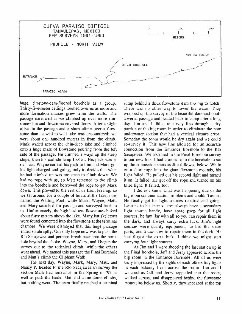
CUEVA PARAISO DIFICILTAMAULIPAS, MEXICO
PEP SURVEYS 1991-1993
PROFILE - NORTH VIEW
o
/'UPPER BOREHOLE
100
METERS
200
NEW EXTENSION
ENTRANCE
- PARAISO ABAJO
huge, rimstone-dam-floored borehole as a group.Thirty-five-meter ceilings loomed over us as more andmore formation masses grew from the walls. Thepassage narrowed as we climbed up over more rimstone-dam and flowstone-covered floors. After a slightoffset in the passage and a short climb over a flowstone dam, a wall-to-wall lake was encountered; wewere about one hundred meters in from the climb.Mark waded across the chin-deep lake and climbedonto a huge mass of flowstone pouring from the leftside of the passage. He climbed a ways up the steepslope, then his carbide lamp fizzled. His pack was atour feet. Wayne carried his pack to him and Mark gothis light charged and going, only to decide that whathe had climbed up was too steep to climb down. Wehad no rope with us, so Matt retreated to the climbinto the borehole and borrowed the rope to get Markdown. This prevented the rest of us from leaving, sowe sat around for a couple of hours at the lake, nownamed the Waiting Pool, while Mark, Wayne, Matt,and Mary searched for passage and surveyed back tous. Unfortunately, the high lead was flowstone-chokedabout forty meters above the lake. Many bat skeletonswere found cemented into the flowstone at the terminalchamber. We were dismayed that this huge passageended so abruptly. Our only hope now was to push theRio Sacajawea and perhaps break back into the borehole beyond the choke. Wayne, Mary, and I began thesurvey out to the technical climb, while the otherswent ahead. We named this passage the Final Boreholeand Matt's climb the Oliphant Walk.
The next day, Wayne, Mark, Mary, Matt, andNancy P. headed to the Rio Sacajawea to survey thesection Mark had looked at in the Spring of '92 aswell as push the leads. Matt did some dome climbs,but nothing went. The team finally reached a terminal
sump behind a thick flowstone dam too big to notch.There was no other way to lower the water. Theywrapped up the survey of the beautiful dam-and-poolcovered passage and headed back to camp after a longday. Jim and I did a re-survey line through a dryportion of the big room in order to eliminate the nowunderwater section that had a vertical closure error.Someday the room would be dry again and we couldre-survey it. This new line allowed for an accurateconnection from the Entrance Borehole to the RioSacajawea. We also tied in the Final Borehole surveyto our new line. I had climbed into the borehole to setup the connection shots as Jim followed below. Whileon a short rope into the giant flowstone mounds, hislight failed. He pulled out his second light and turnedit on. It failed. He got off the rope and turned on histhird light. It failed, too.
I did not know what was happening due to thebig room communication problems and couldn't assist.He finally got his light sources repaired and going.Lessons to be learned are: always have a secondarylight source handy, have spare parts for all lightsources, be familiar with all so you can repair them inthe dark, and always carry extra luck. Jim's lightsources were quality equipment, he had the spareparts, and knew how to repair them in the dark. Hejust forgot the extra luck. I think we might startcarrying four light sources.
As Jim and I were shooting the last station up inthe Final Borehole, Jeff and Jerry appeared across thebig room in the Entrance Borehole. All of us weretruly impressed by the sights of each others tiny lightsin each balcony from across the room. Jim and Iwatched as Jeff and Jerry rappelled into the room,walked across, and disappeared behind the flowstonemountains below us. Shortly, they appeared at the top
The Death Coral Caver No. 3 11

of the Oliphant Walk and joined us for a brief tour ofthe upper borehole. Jeff and Jerry spent the night inthe cave with us so they could start the entrance-toentrance surface survey the next morning.
All of us had noticed that the water level in thebig room had dropped one to two meters during thefew days we were in the cave. This is exactly whathappened during the Spring '92 trip. Due to the rapiddrop observed, we figured the flooding of the bigroom was just short-term flood pulses, so maybe nexttime we would have better luck at re-surveying it andchecking the downstream pit lead heading for ParafsoAbajo. Wayne and I finally named the big room areaLake Inconstance.
The last day, without any going cave, we decidedto have Matt climb to a ceiling lead a short distancefrom camp. This was our last hope. Again, a grappling hook was used successfully in addition to otheraids to gain a high balcony with the meter-diameterlead. It did not go. We de-rigged the cave and beganour long ascent up the cliffs and waterfall with camppacks and rock climbing gear. Thankfully, Brian hadcome down to help carry the "heavy metal." By thetime Wayne and I were up, the weather had turnedcold and nasty. Matt, Nancy W., and I built a smallfire in an alcove amongst the boulders to stay warm asthe last ropes were being coiled. We all carried gearup the arroyo and staged it for the pull up the Coronacliff the following morning.
Everyone made it back to their respective homeswithout incident, except for a little trouble with u.S.Customs. Terry and I in my truck and Jim and Jeff inJim's truck crossed the border at Brownsville aroundmidnight on a Saturday. The trouble started with acouple of female officers who apparently felt they hadto show their machismo (masculine intended) to us,their peers, and their bosses. Well, the lady officialsdecided to put the dog on our trucks and brought overa poorly-trained puppy that didn't know the differencebetween contraband and cookies. One official commented that the dog had not yet been to obedienceschool; say what? Finally after an hour and a half orso, they begrudgingly let us go. Jeff had cookies, wehad trail mix, Customs had arrogant, unprofessionalattitudes and an untrained dog, we got hassled.
APRIL 1993
In early April a Parafso team including JerryAtkinson, Wayne Bockleman, Mary Thiesse, PaulFambro, Terry Gregston, Jeff Horowitz, Mark Minton, Nancy Weaver, and John Schweyen returned for
perhaps the final trip to the cave. We had no goingleads other than possibly the downstream lead towardsAbajo if Lake Inconstance was non-existent. And thatwas heading out of the cave. However, Mark wantedto take one last look at the sump in the Rio Sacajaweaand had asked John to accompany us with light-dutydive gear. We also wanted to look at the Waiting Poolin the Final Borehole one last time for an underwaterlead that we might have missed during Thanksgiving.As it turned out, the winter had been the driest thelocals had seen since most could remember.
Wayne, Mary, Paul, Terry, Mark, and John werethe cave camp team. We did our now-standard riggingof the cliffs, waterfall, and cave. The water flow fromthe Corona was noticeably lower and the resurgencepool was kind of scummy. We did not want to haul allthe dive gear down to the cave until we had a look at
"Liontail" formations in Paraiso Dificil. 1993 photo by PaulFambro
the Sacajawea Sump, so it was staged at the bottom ofthe Corona cliff. This would allow reasonable accessto it if needed. Camp was set in the usual place and aquick check of the big room found Lake Inconstancedry. Mark and John did a quick trip to the sump andfound open air space in a place they did not expect.Air was roaring through the small air space andcreating standing waves on the water surface. The nextday, Mark, Wayne, Mary, and John returned to thesump in wet suits to attempt a dive through and surveybeyond. They found good passage with several leads.All were surveyed; however, the air flow was notspecifically located. They were about to give up whenMark dropped through a small opening in a passagefloor. He dropped into stoop-walking and walkingpassage with good airflow. He and Wayne explored a
12 The Death Coral Caver No. 3
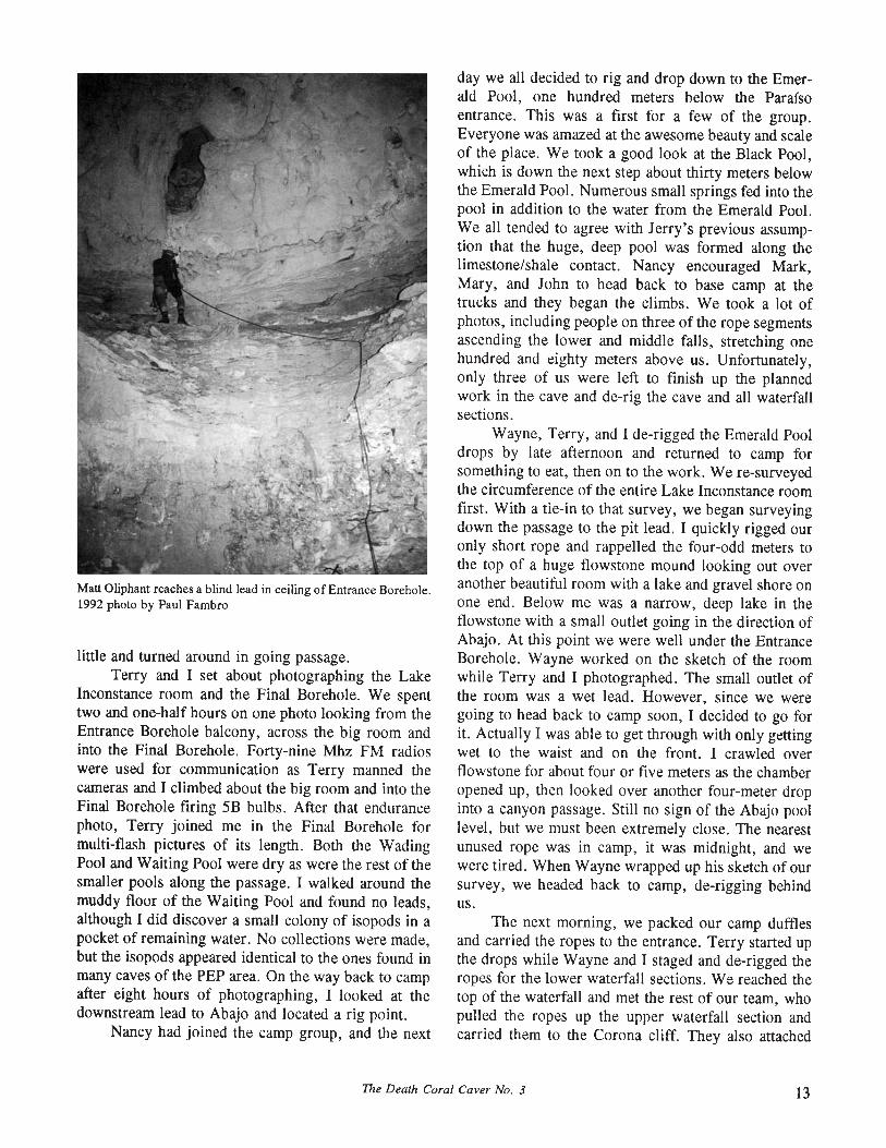
Matt Oliphant reaches a blind lead in ceiling of Entrance Borehole.1992 photo by Paul Fambro
little and turned around in going passage.Terry and I set about photographing the Lake
Inconstance room and the Final Borehole. We spenttwo and one-half hours on one photo looking from theEntrance Borehole balcony, across the big room andinto the Final Borehole. Forty-nine Mhz FM radioswere used for communication as Terry manned thecameras and I climbed about the big room and into theFinal Borehole firing 5B bulbs. After that endurancephoto, Terry joined me in the Final Borehole formulti-flash pictures of its length. Both the WadingPool and Waiting Pool were dryas were the rest of thesmaller pools along the passage. I walked around themuddy floor of the Waiting Pool and found no leads,although I did discover a small colony of isopods in apocket of remaining water. No collections were made,but the isopods appeared identical to the ones found inmany caves of the PEP area. On the way back to campafter eight hours of photographing, I looked at thedownstream lead to Abajo and located a rig point.
Nancy had joined the camp group, and the next
day we all decided to rig and drop down to the Emerald Pool, one hundred meters below the Parafsoentrance. This was a first for a few of the group.Everyone was amazed at the awesome beauty and scaleof the place. We took a good look at the Black Pool,which is down the next step about thirty meters belowthe Emerald Pool. Numerous small springs fed into thepool in addition to the water from the Emerald Pool.We all tended to agree with Jerry's previous assumption that the huge, deep pool was formed along thelimestone/shale contact. Nancy encouraged Mark,Mary, and John to head back to base camp at thetrucks and they began the climbs. We took a lot ofphotos, including people on three of the rope segmentsascending the lower and middle falls, stretching onehundred and eighty meters above us. Unfortunately,only three of us were left to finish up the plannedwork in the cave and de-rig the cave and all waterfallsections.
Wayne, Terry, and I de-rigged the Emerald Pooldrops by late afternoon and returned to camp forsomething to eat, then on to the work. We re-surveyedthe circumference of the entire Lake Inconstance roomfirst. With a tie-in to that survey, we began surveyingdown the passage to the pit lead. I quickly rigged ouronly short rope and rappelled the four-odd meters tothe top of a huge flowstone mound looking out overanother beautiful room with a lake and gravel shore onone end. Below me was a narrow, deep lake in theflowstone with a small outlet going in the direction ofAbajo. At this point we were well under the EntranceBorehole. Wayne worked on the sketch of the roomwhile Terry and I photographed. The small outlet ofthe room was a wet lead. However, since we weregoing to head back to camp soon, I decided to go forit. Actually I was able to get through with only gettingwet to the waist and on the front. I crawled overflowstone for about four or five meters as the chamberopened up, then looked over another four-meter dropinto a canyon passage. Still no sign of the Abajo poollevel, but we must been extremely close. The nearestunused rope was in camp, it was midnight, and wewere tired. When Wayne wrapped up his sketch of oursurvey, we headed back to camp, de-rigging behindus.
The next morning, we packed our camp dufflesand carried the ropes to the entrance. Terry started upthe drops while Wayne and I staged and de-rigged theropes for the lower waterfall sections. We reached thetop of the waterfall and met the rest of our team, whopulled the ropes up the upper waterfall section andcarried them to the Corona cliff. They also attached
The Death Coral Caver No. 3 13
the heavy, unused diving gear to the ropes. It was ahot day, and the vertical hike out was not a lot of fun.As soon as we reached base camp, Jerry and a few ofus began rigging a Z-line to haul the ropes and divegear up the two hundred and twenty-odd meter cliff.Four locals showed up to watch and offered pullingassistance. Somewhere around six hundred meters ofstrung-out ropes and eighty pounds of dive gear tookits toll on us and the locals. After getting the sack ofdive gear up, things went a lot easier. The ropes werecoiled and carried to the trucks. At least for three ofus, it was a first to pack out of camp in the cave,climb and hike all the way to the top, and de-rig allropes and gear for the entire trip in one day. We wereburnt.
Everyone packed their trucks and rolled forTexas the next morning. There were no border cross-
ing hassles, just the normal look-and-see. Afterthinking that this might have been the last trip toParafso, we now have two leads that are going. One,of course, is heading to Abajo with nice passage andthe other is heading to the east-southeast with good airflow, which is trending away from the Final Boreholethat has a southerly trend. Mark was able to makesome gentle modifications that he thinks will keep theSacajawea Sump open even at non-low water times, soconsistent access should not be a problem in thefuture. The cave passes under Cueva del Rfo Coronawith two hundred vertical meters of separation, andeven deeper than the borehole levels of S6tano de lasCalenturas. The going passage is heading in a directionof no other known caves. While we scratch our headstrying to figure this all out, we will be planning areturn trip for late March 1994.
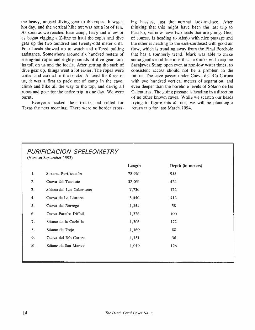
PURIFICACION SPELEOMETRY(Version September 1993)
Length Depth (in meters)
1. Sistema Purificaci6n 78,961 955
2. Cueva del Tecolote 32,031 424
3. S6tano del Las Calenturas 7,730 122
4. Cueva de La Uorona 3,540 412
5. Cueva del Borrego 1,354 58
6. Cueva Paraiso Diffcil 1,326 100
7. S6tano de la Cuchilla 1,306 172
8. S6tano de Trejo 1,160 80
9. Cueva del Rio Corona 1,151 36
10. S6tano de San Marcos 1,019 126
14 The Death Coral Caver No. 3

Contributors: Dale Pate and Peter SprouseFaunal lists compiled by James R. Reddell
Val Ellis (I) and Peter Sprouse in the bottom chamber of Pozo de Las Chinas. 1989 photo by Susie Lasko
POZO DE LAS CHINAS PEP 200Las Chinas, TamaulipasLength: 190 meters Depth: 162 metersUTM coordinates: E 454,650 N 2,638,276
Pozo de Las Chinas is located 100 meters southeast of Rancho Nuevo at an elevation of 2685 meters.The entrance is situated on the east side of the RanchoNuevo-Mesas Juarez road, not far south of a smallllano which was used as a camp during the explorationof the cave. A lO-meter-diameter sink with severalsoyate palms funnels down into the 154-meter entrancepitch. A slight offset occurs 25 meters down at anarrow ledge, but the rope barely touches. Another
ledge just deflects the rope at -85 meters, where astanding rebelay could be installed to good advantage.At -154 meters the rope lands at the top of a talusslope. This slope descends to a flat mud floor which isthe terminus of the cave.
Pozo de Las Chinas was discovered on 1 September 1989 when a truckload of cavers drove a shortstretch of road which had not been previously checked.Exploration and survey was done the next day by ValEllis, John Fogarty, Susie Lasko, and Peter Sprouse.This was made a bit difficult by communicationsproblems in the deep pit; FM headset radios proved tobe of little help, perhaps due to the narrowness of theshaft. (PS)
The Death Coral Caver No. 3 15
PR
OY
EC
TO
ES
PE
LE
OL
OG
ICO
PU
RIF
ICA
CIO
N
o 40 50 60 7030
~l
I, :~1__
IrrG
\
i~
~-
i\:
\('
1\
~-
10
)~'I
\'
II
J20
III
'I\
Lev
el1
-
entr
ance
~
Lev
el1
pla
n
LA
SC
HIN
AS
,E
JID
OR
EV
ILL
AT
AM
AU
LIP
AS
,M
EX
ICO
met
ers
o5
1015
I!,
I!
II
PE
Pst
anda
rdca
vem
apsy
mbo
ls
PE
P20
0
Su
un
tos
and
tap
esu
rvey
2S
epte
mb
er19
89
Val
Elli
s,Jo
hnF
ogar
ty,
Sus
ieL
asko
,P
eter
Sp
rou
se
Dra
fted
by
Pet
erS
pro
use
Len
gth:
190
met
ers
Dep
th:
162
met
ers
UT
Mco
ordi
nate
sE
:454
,650
N:2
,638
,276
sink
PO
ZO
DE
LA
SC
HIN
AS
~ ~ ~ " ".... ~ v"~ " tl "l:l So..... 0'1
Lev
el2
pla
n
~.,
..0.:
'.:\
•,t
>.
°11.> -
Pla
nse
ctio
nsro
tate
d24
8de
gree
s
~*
Nm
Lev
el2
-
Chi
naW
enP
154
Pro
file
:27
0de
gree
view
~u 90 100
110
120
130
140
160
150
met
ers
162
I i--
Lev
el3
-
tem
p.12
.2de
g.C
7L
evel
3p
lan
-Q
-"
.,-
,,-~-0n
-_
"(\!!
.IV-
_'C
:>-
r-
--
_I-
_-
f
leA-
---
I'"
--
-I
_-
f-
,~
1\ I \
Viii
yiI
IlfI
lI~
Ilili
1¥
OQO~=,,-
"'.
o'"
"'-'Q" ",0
,
~ '" tl '"I'l So ~ ~ ~ "" '"... ~ Vv ......
-..l
~Nm
j
Drafw;l by Dale Pllte
Val Ellis Susie l..uk.oDale Fale
PEP 208
SUl.Jl'..,T"J"OS & TAPE SURVEY
20 October 1989
Tamaulipas, Mexico
elev. 2700 m.elen
Proyecto Esp€Ie61ogico Purificaci6n
L"'TM: c.oo~din.a.tes E:~54,820 N:2,638,.317
30
20
10
40
-57
POZO Galil eo
meters to a small ledge, and then continues against thewall for another 22 meters to a dirt floor with wooddebris and small rocks. The entrance pit averages 8 to10 meters wide and has a stalagmite/curtain hangingabout halfway down on its northern side. At thebottom a small squeezeway leads to 10 meters ofdecorated passage, then ends in a dome that extendsupwards for 15 meters.
Pozo Galileo was located on 19 October 1989 byDale Pate and Cathy Winfrey. It was explored thefollowing day by Dale, Val Ellis, and Susie Lasko.The pit was named in honor of the space probe Galileowhich was launched at the same time. A centipedewhich appeared to be troglobitic was seen in the cavebut eluded capture. (DP)
Spiders: Nesticus sp. (troglophile)Modisimus sp. (troglophile)
Millipedes: Xystodesmidae genus and species (troglophile)Ground beetles: Trechini genus and species (troglobite)Moths: Lepidoptera undeterminedFlies: Diptera undetermined
~Nm
IDLP
19 October 1989
6--meters
Dale Pate Cathy Winfrey
Plan
SUUNTOS & TAPE SURVEY
elev. 2710 meters
UTM coordinates E:454,885 N:2,638,290
Profile
TM"IAUUPAS, MEXICO
PEP 207
POZO YERBABUENA
POZO YERBABUENA PEP 207Las Chinas, TamaulipasLength: 10 meters Depth: 10 metersUTM coordinates: E 454,885 N 2,638,290
This small pit is located 1250 meters southeast ofRancho Nuevo, just uphill from Pozo Galileo at 2710meters elevation. The entrance measures 1.5 by 2meters, and it drops 9.7 meters to a dirt fill. PozoYerbabuena was located and explored on 19 October1989 by Dale Pate and Cathy Winfrey. (DP)
Earthwonns: Haplotaxida undetenninedTerrestrial isopods: Trichoniscidae genus and species (troglobite)Spiders: Cicurina (Cicurella) sp. (troglophile)
Nesticus rainesi Gertsch (troglophile)Mites: Acarina undetenninedHarvestmen: Phalangodidae genus and species (?troglobite)Millipedes: Xystodesrnidlle genus and species (troglophile)Springtails: Oncopodura susanae Christiansen and Reddell (troglobite)Cave crickets: Rhaphidophoridae genus and species (trogloxene)Ground beetles: Trechini genus and species (troglobite)
POZO GALILEO PEP 208Las Chinas, TamaulipasLength: 65 meters Depth: 57 metersUTM coordinates: E 454,820 N 2,638,317
This pit is located 1200 meters southeast ofRancho Nuevo at an elevation of 2703 meters. It is onthe east edge of the fire tower road. The entrance is 5meters long by 2 meters wide, with a natural bridgenear its northern end. The pit drops mostly free for 30
POZO JESUPLASTICO PEP 269Las Chinas, TamaulipasLength: 184 meters Depth: 78 metersUTM coordinates: E 454,140 N 2,641,540
This pozo is situated 2400 meters north ofRancho Nuevo at an elevation of 2575 meters. It ispartway down the slope of a dolina through which alogging spur road passes, a side road which goes left
18 The Death Coral Caver No. 3
CUEVA DE LA NIEVE
ALTAS CUMBRES, TAMAULIPAS
PEP 238
Surveyed 16 January 1992
M. Crawford, S. Lasko, P. Sprouse
o 5 10
J I I I ,
15I I
Drafted by Troy Laniermeters
Length: 55 Meters Depth: 16 Meters
Plan
~'~_"."'~":"""~:OoO~ ',' o.~~.:_,·,,~··~",entrance •. .' . (:> .. 0 • o.·•.~.~:::.:-:.~~~-.;.;,..:..:.~-=-~~~.....:---:.._.;.....~
0'( D q. f- '. -;': ~ .. . •. .'V t ..•. ,1. '0·,·· .~ ~
~~~
"b-
16 meters
,
.. ~lOtI/lOr,I..
- elevation 1270 m~-
Profile
........... --- ---
entranceo
t>~t>
o
10
5
logging spur road passes, a side road which goes leftoff of the Cueva de California road. The entrancemeasures 1 by 2 meters and drops 5 meters to the topof a rubble slope. This leads down to a second dropsituated below a shrine-like niche in the wall. Thisdrop begins in a narrow, corkscrew fashion, thenopens up into a wide rift. The bottom is a rubblestrewn ledge 4 meters square which opens out into thethird drop. This 13-meter pitch drops through the roof
of a wide formation room. Down a flowstone slope tothe south are two muddy and wet alcoves, one ofwhich has a tall dome over it. In the floor just beforethese alcoves is a 7-meter-deep blind pit.
Upslope from the bottom of the third drop thepassage widens into a flowstone landscape punctuatedby scattered stalagmites. The north end slopes backdown to another drop, a flowstone funnel whichbecomes too tight to enter, but which appears to bell
The Death Coral Caver No. 3 19

out below. At the top of this drop is a spectaculardisplay of thin eccentric totems. A west-trending sidepassage off the middle of the formation chamber goesto a short downclimb and then a longer upclimb. Amud-and-flowstone ramp leads up to the edge of a24-meter shaft. At the bottom of this is a small pooland a window into another pit. This one drops 10meters and has passages going both north and south atthe bottom. The south passage goes up a rocky slopeto the bottom of a dome. The north passage ducksunder a ledge and curves around to the right to anotherdome. A hole in the floor before this dome pinches atthe deepest point in the cave. (see map p 29)
Pozo Jesuplastico was located in February 1993when a PEP team set up camp next to it for a week ofpit-pushing. It was explored and mapped on 17-18February 1993 by David McKenzie, Charley Savvas,Peter Sprouse, and Cathy Winfrey. (PS)
lsopods: Trichoniscidae genus and species (troglobite)Millipedes: Diplopoda undeterminedCave crickets: Rhaphidophoridae genus and species (trogloxene)
CUEVA DE LA NIEVE PEP 238Altas Cumbres, TamaulipasLength: 55 meters Depth: 16 metersUTM coordinates: E 478,660 N 2,610,340
Cueva de la Nieve is located 400 meters west ofthe village of Altas Cumbres at 1270 meters elevation.It is on a steep slope between Highway 101 and theHuisachal road. The entrance is in the base of a cliff,and the whole cave appears to be tectonically formedby a slump block. The cave is a single linear rift.From the entrance a rubble slope leads down to a dirtfloor. A large breakdown block is passed, then thecave trends up into a flowstone pinch. This cave wasshown to John Fogarty, Leonard Pruitt, Peter Sprouse,and others in September 1989 by local women. It wasmapped after a snowstorm on 16 January 1992 byMichael Crawford, Susie Lasko, and Peter Sprouse(see DCC no. 2, page 35). (PS)
SOTANO DE AGUA DE LAS VACAS PEP 152Agua de las Vacas, Nuevo LoonLength: 40 meters Depth: 31 metersUTM coordinates: E 450,062 N 2,650,015
This pit is along the right (west) side of the roadto Agua de las Vacas, 300 meters after it splits offfrom the main Revilla-Los Caballos road. It is situatedon a forested slope at 2050 meters elevation. It hastwo pit entrances which join in a 3-meter-wide rift.
Tectonic rift in Cueva de la Nieve. 1992 photo by Susie Lasko
The small upper pit entrance drops onto steep bedrockramp formed on beds dipping southwest at 70 degrees.The lower entrance is a 2 by 3 meter pit that dropsfree for 21 meters, landing on the slope where itsgradient lessens and the floor turns to rubble. The caveends in a small flat silted area at the foot of the rubbleslope. This pit was explored and surveyed on 29December 1986 by Peter Sprouse and Terri Treacy.(PS)
Spiders: Phonotimpus sp. (?troglophile)Darkling beetles: Eleodes (Caverneleodes) sprousei Triplehorn and Reddell
(troglophile)
CUEVA DE AGUA DE LAS VACAS PEP 155Agua de las Vacas, Nuevo LoonLength: 30 meters Depth: 17 metersUTM coordinates: E 449,840 N 2,649,330
This cave is located 100 meters northwest of thevillage of Agua de las Vacas, at an elevation of 2145meters. The small entrance opens into a slopingpassage which enlarges to 4 by 4 meters. After 25
The Death Coral Caver No. 3

meters there is a short downclimb leading to a tightpinch. Cueva de Agua de las Vacas was explored andsurveyed on 29 December 1986 by Peter Sprouse andTerri Treacy. (PS)
I ... -... ·,~
JPEP 97
SURVEY 29 NOvEMBER 1981P FAMBRO. P.SPROUSE
DRA'NN BY P SPFIOUSE. T. TREACYIENGTII 65 METEAS DEPTH: ~5 MEfERSUIM COORDINATES E.~l.950 W2.~2.130
SOTANO DE LAS TRES VENTANASEJIDO CUAUTEMOC, NUEVO LEON
Springtails: Collembola undeterminedSlender entotrophs: Campodeidae genus and species (?troglobite)Cave crickets: Rhaphidophoridae genus and species (trogloxene)Darkling beetles: Eleodes (Caverneleodes)sprousei Triplehorn and Reddell
(troglophile)Flies: Chironomidae genus and species
SOTANO DE AGUA DE LAS VACASAGUA DE LAS VACAS, MUN. DE ZARAGOZA
NUEVO LEON, MEXICO
------------r'" ..: ~
J }:'::'" '.' •
~IAJN10$ M"f} 'I\I'E SU"VEY ?'l DECfUI)£Il 19M~ srnov:.e. T. Tr1£ACY
OM....'N BY P. SPAOVS£ IWO r. TllEACYLE'''Gnt ~ lAE1EIlS O€Pm:n METEns
UTJol CQQf.....l..: £.•50.0&2 N:Z.6SO,OI5
PEP 152
Terrestrial isopods: Trichoniscidae genus and species (troglobite)Spiders: Phonotimpus sp. (troglophile)
Modisimus rainesi Gertsch (troglophile)Millipedes: Diplopoda undetenninedSlender entotrophs: Campodeidae genus and speciesInsects: Insects larvae undetermined
...--------------------_._..•..
CUEVA DE AQUA DE LAS VACASAGUA Of LAS VACAS. NUEVO LEON
SOTANO DE LAS TRES VENTANAS PEP 97Cuauhtemoc, Nuevo LoonLength: 65 meter Depth:45 metersUTM coordinates: E 451,950 N 2,642,130
Cueva de las Bandanas is located 500 metersnorthwest of Revilla at an elevation of 2245 meters.An arroyo which crosses the main road just north oftown drains into the entrance. The cave dips down 45 0
bedding to quickly end in a pinch. David Honea andJeanne Williams located this entrance in April 1980. Itwas explored and mapped on 17 April 1980 by DavidHonea, Dale Pate, and Randy Rumer, who had tocover their mouths with bandanas due to the thickgnats. (PS)
CUEVA DE LAS BANDANAS PEP 49Revilla, Nuevo LoonLength: 18 meters Depth: 16 metersUTM coordinates: E 450,930 N 2,647,795
~,
SLIIJNTOS AND TAPE SURVEY <"lOfCEI,l!l£R 19'1ep_ SPROllSE.. 1. mu,CV sPROUSE
OAAWN 8VP, sPROUSE. T. TJlEACVLENGTH. 27 MElEl'IS DEP~_ IT NElERSlJO,I CCK:lf«)l"''''~S E_.~.&*O N.2.~9.330
CUEVA DE LAS BANDANASAGUA DE LAS VACAS, NUEVO LEON
Harvestmen: Gagrellinae or Leiobuninae genus and species (trogloxene)Centipedes: Lithobiomorpha undeterminedMillipedes: Cleidogona yerbabuena Shear (troglophile)Flies: Diptera undetermined
This pit is located 1750 meters south-southwestof Ejido Cuauhtemoc at an elevation of 2210 meters,It is in a sink by a road in a wide drainage. Theentrance pit drops 35 meters to a rubble pile, whichslopes down to fill at -45 meters. Temperature measured at this point was 8.6 0 Celsius during explorationon 29 November 1981 by Paul Fambro and PeterSprouse. (PS)
Spiders: Modisimus reddelli Gertsch (troglophile)Harvestmen: Leiobuninae n. gen. near Nelima and Paranelima,
n. sp. (trogloxene)Leiobunum viridorsum Goodnight and Goodnight (trogloxene)
Centipedes: Lithobiomorpha undetenninedMillipedes: Glomeroides palei Shear (troglobite)
Cleidogona yerbabuena Shear (troglophile)
PEP 49
SUUNTOS AND TAPE SU'M:Y 17 APRIL 1980D. HONEA, O. PATE. R. RuMER
DRAWN BY P. SPROUSE AND T. TREACYLENGTH: 18 METERS DEPTH: 16 METERSUTM COORDINATES E:450.930 N:2.647,795
-D -~l
~""""::'::
.' .-' LTAG~~·',: . L ".
_ ... -" '.' . Nm~
ELEV. 2245 M METERS 0
'0
'6
The Death Coral Caver No. 3 21
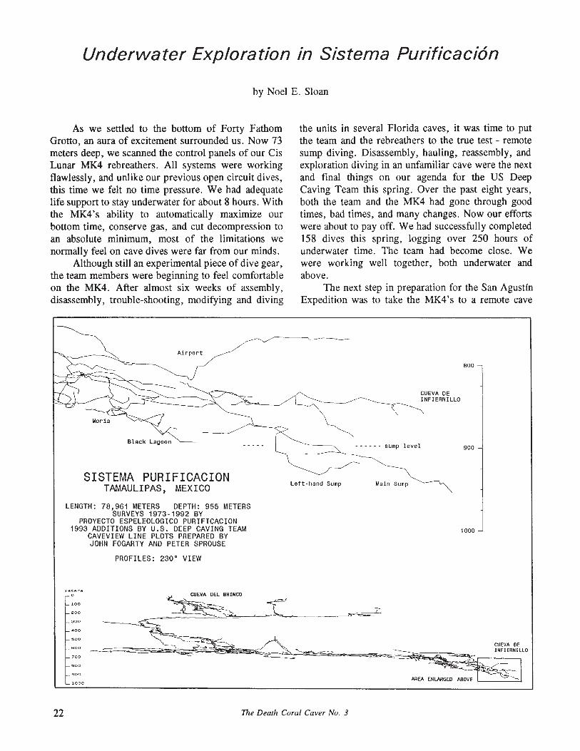
Underwater Exploration in Sistema Purificaci6n
by Noel E. Sloan
As we settled to the bottom of Forty FathomGrotto, an aura of excitement surrounded us. Now 73meters deep, we scanned the control panels of our CisLunar MK4 rebreathers. All systems were workingflawlessly, and unlike our previous open circuit dives,this time we felt no time pressure. We had adequatelife support to stay underwater for about 8 hours. Withthe MK4's ability to automatically maximize ourbottom time, conserve gas, and cut decompression toan absolute minimum, most of the limitations wenormally feel on cave dives were far from our minds.
Although still an experimental piece of dive gear,the team members were beginning to feel comfortableon the MK4. After almost six weeks of assembly,disassembly, trouble-shooting, modifying and diving
the units in several Florida caves, it was time to putthe team and the rebreathers to the true test - remotesump diving. Disassembly, hauling, reassembly, andexploration diving in an unfamiliar cave were the nextand final things on our agenda for the US DeepCaving Team this spring. Over the past eight years,both the team and the MK4 had gone through goodtimes, bad times, and many changes. Now our effortswere about to payoff. We had successfully completed158 dives this spring, logging over 250 hours ofunderwater time. The team had become close. Wewere working well together, both underwater andabove.
The next step in preparation for the San AgustinExpedition was to take the MK4's to a remote cave
Black Lagoon
SISTEMA PURIFICACIONTAMAULIPAS, MEXICO Left· hand Sump
CUEVA DEINFIERNILLO
- - - - - - sump level
Main Sump
800
900
LENGTH: 78,961 METERS DEPTH: 955 METERSSURVEYS 1973-1992 BY
PROYECTO ESPELEOLOGICO PURIFICACION1993 ADDITIONS BY U.S. DEEP CAVING TEAM
CAVEVIEW LINE PLOTS PREPARED BYJOHN FOGARTY AND PETER SPROUSE
PROFILES: 230 0 VIEW
1000
meterso
200
000
400
600
700
900
1000
22 The Death Coral Caver No. 3

which would involve underground camping, verticalwork, unit disassembly and transport and true exploration diving. With the help of Peter Sprouse, theInfiernillo entrance of Sistema Purificaci6n was theperfect choice. The cave more than met our needs.With only ten days left before the group had to returnto their respective jobs, we had to be efficient. Froma previous dive attempt by Bill Stone, we knew thedives would likely be deep. If we could successfullyadd another 96 meters through our dive exploration thesystem would pass the one-kilometer mark.
Out of necessity, the team, consisting of KennyBroad, Jim Brown, Barbara am Ende, Steve Porter,Peter Sprouse, and myself, left San Antonio aboutlOpm 12 May, geared for an all night drive. Betweenthe team and our gear, Bill and my Toyota trucks wereat maximum load. By the following evening, we werecamped at the head of the arroyo leading to theInfiernillo entrance. Planning an early start, Barbaraand Kenny went with Peter to rig the entrance andidentify survey tie-in points.
The next morning, 14 May, was a stark reminderof how much work sump diving can be as we begancountless trips up the arroyo balancing and slipping onthe moss-covered boulders. We had brought threerebreathers, but there were no objections to theproposal that we only take two to the cave. By lateafternoon, we had all the gear below the entrance. Wequickly rigged a highline and began hauling the upequipment. As darkness settled in, it brought a heavyrainstorm which hampered our efforts. We gathered upthe necessary sleeping gear and entered the cave to setcamp. The gear hauling could wait until morning.
Day 3 began with gathering the remaining gearfrom the canyon floor, followed by three trips to theentrance to get the essentials carried to the MainSump. We staged the rest of the gear inside theentrance. By late afternoon, we were prepping the divesite for the first exploratory dive in the morning. Thereassembly of the MK4 went much easier than expected until a systems check revealed a nonfunctionaloxygen sensor. No problem. We expected repairs, butto our horror we found the replacement sensors lackedproper connectors for any easy repair. With a screwdriver and camp stove, Bill had a makeshift solderingiron. Before long we had the unit up and running. Thecountless hours we had spent assembling and troubleshooting the rebreathers had paid off. Makeshift fieldrepairs were an expected part of using the complexnew dive gear.
The morning of May 16 found us ready for thefirst exploratory dive. The team decided to minimize
the amount of gear we hauled to conduct our explorations; thus we would all be diving solo. Steve wouldmake the first dive and I the second. Our findingswould determine the next step. Breakfast went slowlyas Steve contemplated the seriousness of his morningahead.
The sump pool, about 6 meters wide and 20meters long, appeared both ominous and inviting. Wecould do our dives on either nitrogen or helium. Wehad brought high pressure composite cylinders withboth air and trimix for our safety bailout. With hopesthat the dive would stay shallow, and concerns overdiving at altitude on an MK4 that Bill had just repaired, Steve chose air. As Steve disappeared into thewater, his 20 watt dive light illuminated a faint milkiness to the water, producing an eerie glow. We assumed this was from the mineral content in the water.About 30 minutes into the dive we were relieved to seehis light return. He took another 30 minutes to surface. Steve emerged from the 16.5°C water, obviouslycold. He had laid 104 meters of line, stopping at adepth of 34 meters. The ceiling was continuing todrop, and the floor was questionably visible deepbelow.
The next morning it was my turn to solemnlycontemplate the dive ahead. Even at the end of ourdiving in Florida, we found that often our attentionwas on the rig rather than on the dive itself. Unlikethe cave diving we were used to doing, a completeconfidence in our equipment was still lacking. Buoyancy control with a rebreather is more complex thanScuba. The complications of monitoring the rig whilediving, the team's view of the unit as experimental,coupled with exploration of a remote cold water sumpat altitude, was definitely task loading. You could seeit in our eyes and hear it in our voices as we undertook each dive with the seriousness of our own personal fears.
Knowing that the new exploration was goingdown from 34 meters, I chose heliox for my dive.After entering the water I felt the excitement build atthe thought of making an exploration dive on the rig.I had plenty of gas and minimal time pressure. Atabout 9 meters depth and about 20 meters back, wherethe true sump begins, suddenly my composure wasshattered as the main LCD control panel went dead.
We had seen this before, most likely dead batteries, I thought. With Steve and Barbara's help, Billchanged the main system batteries at the water's edgewhile I was still wearing the unit. Now, having beengraphically reminded of the problems we had encountered during our R&D dives, I set out to finish the
The Death Coral Caver No. 3 23
task at hand. The water was not as clear as I hadexpected. It had a thick milky hue which limited mydive light penetration to less than 10 meters. Steve hadlaid his dive line along the right wall as shallow aspossible. Not far beyond the end of the sump pool thepassage widened dramatically. No floor, left wall, orceiling were visible. The size of the passage wascertainly as big as anything we had seen above water.At about 18 meters deep, the wall no longer appearedas solid rock. Instead it was covered with cauliflowershaped formations of calcite encrusted mud. I finallyreached the end of Steve's line at 30 meters. Therewas no tie-off. Rather, a small loop in the line hadbeen gingerly laid over a small mud formation. At thispoint, the ceiling was dropping sharply and the onlyway on was straight down. When I tried to tie to theline loop on the wall a sheet of these mud formationscame loose, considerably reducing the visibility.Taking this as an omen, I decided to abort and becontent with surveying the existing line out. I finallymanaged to re-establish a tie-off by poking the lineinto the mud formations with my finger.
On surfacing, after only a 30 minute dive, Billconvinced me to give it another try. When I againreached the end of the line, a combination of the nOwpoor visibility and the cold I was feeling after being inthe water over an hour easily convinced me to put thisoff until tomorrow. I was shivering when I ended thesecond dive. It was becoming apparent that we neededdry suits.
While I was diving, Bill and Barbara had gone todo a lead-climb that looked extremely promising. Thelead appeared to be a large shaft in the ceiling of thelatrine chamber between camp and the sump. With thehelp of Peter's Toshiba hammer-drill, and a couple ofdivelight battery packs, they pursued a very challenging and overhung climb.
I was determined to finish what I had started. Sothe next day I would make the first dive, followed bySteve. Bill, determined to set a depth record, insistedon our carrying a depth gauge tied to a small line reelfor plumbing the bottom. Knowing what was ahead,this dive was much more relaxed. After successfullytying into the end of the line, I dropped down, settlingon the floor at 45 meters. I wanted a tie-off at thispoint. Not seeing one, I used a lead drop weight. Iwas now in what appeared to be a large tunnel, but thevisibility prevented me from estimating its size. Iexplored another 18 meters before turning the dive dueto the cold. Unfortunately, all the deep diving inexcess of 60 meters at Forty Fathom Grotto just priorto this trip had crushed our wet suits to about half
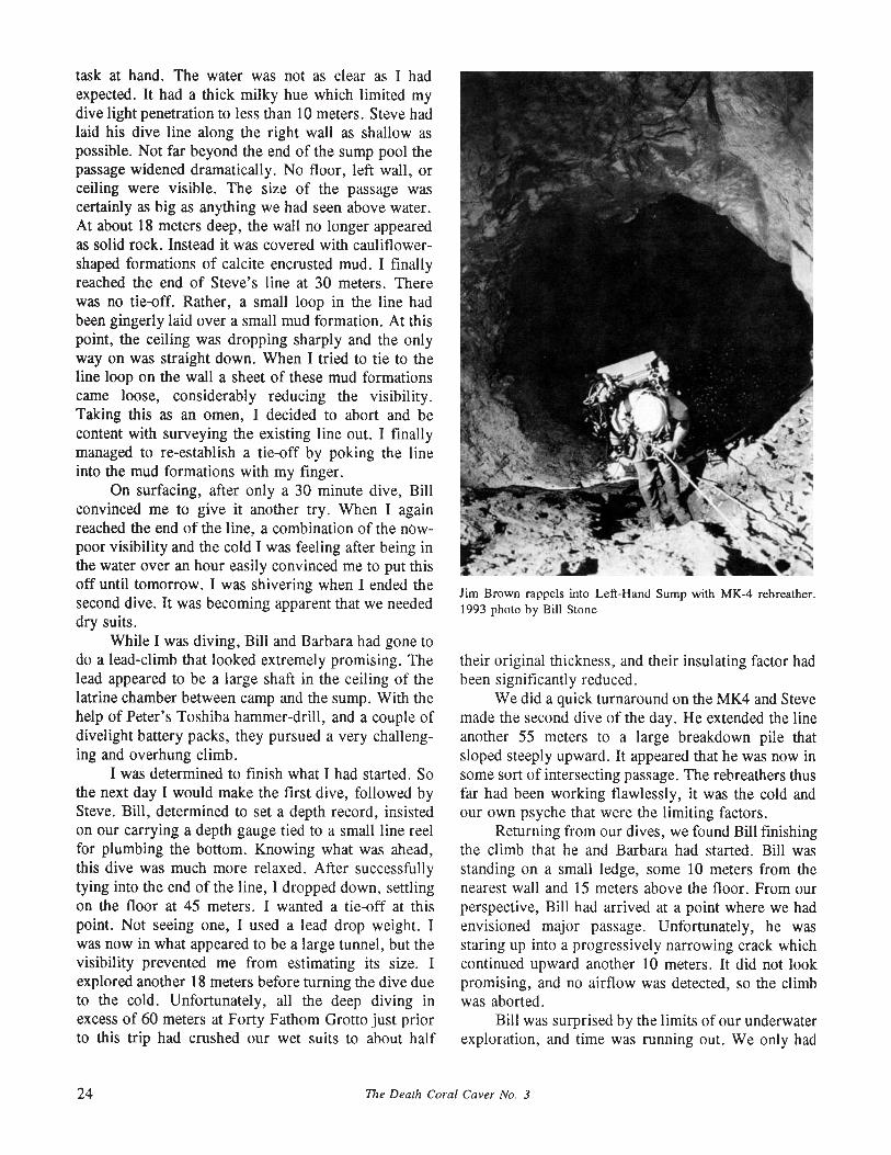
Jim Brown rappels into Left-Hand Sump with MK-4 rebreather.1993 photo by Bill Stone
their original thickness, and their insulating factor hadbeen significantly reduced.
We did a quick turnaround on the MK4 and Stevemade the second dive of the day. He extended the lineanother 55 meters to a large breakdown pile thatsloped steeply upward. It appeared that he was now insome sort of intersecting passage. The rebreathers thusfar had been working flawlessly, it was the cold andour own psyche that were the limiting factors.
Returning from our dives, we found Bill finishingthe climb that he and Barbara had started. Bill wasstanding on a small ledge, some 10 meters from thenearest wall and 15 meters above the floor. From ourperspective, Bill had arrived at a point where we hadenvisioned major passage. Unfortunately, he wasstaring up into a progressively narrowing crack whichcontinued upward another 10 meters. It did not lookpromising, and no airflow was detected, so the climbwas aborted.
Bill was surprised by the limits of our underwaterexploration, and time was running out. We only had
24 The Dearh Coral Caver No. 3
two days left. Bill still had dreams of a 96 meter-deepdive taking the system depth over 1000 meters. Thus,it was Bill's turn to dive. As the dive approached, itbecame obvious that Bill, too, shared the apprehensions we had felt. His dive plan was to follow the lineto the end and continue exploration in the most promising direction. As he entered the water he said "I'mgoing to keep it simple, I may not lay any line." Iknew what he was thinking. Bill reached the largeboulder where Steve had tied his line. Unlike theprevious dives, Bill had a much brighter 50 watt light.Bill found a 45 0 boulder pile angling upward to thenorth in a passage 18 meters wide by 14 meters tall.Down and to the west, another dark tunnel continued.Bill dropped down from the boulder tie-off to a gravelpassage floor at 57 meters. As on the previous dives,the cold became a deciding factor, it was time toleave. On his return, Bill discovered a shaft in thefloor of the Main Sump pool. We had all been sofocused on the dive line that this rather obvious featurehad been overlooked.
Jim, who had been recovering from a cold, wasnow ready to dive. He had been busy the past dayrigging ropes in the 12-meter shaft above the LeftHand Sump and assembling his dive gear at thebottom. After Bill's dive, we broke down the MK4and Jim hauled it to the Left-Hand Sump. Bill and Iassisted Jim into the water. The water looked good. Itseemed to lack the milky white haze we had seen inthe Main Sump. We watched with envy as Jim set outon what looked to be the best dive of the trip. Duringthe wait, with Barbara's help, we surveyed tie-inpoints between the sump and the main survey.
When Jim surfaced after an hour dive, he confirmed my intuitive expectations. It was the best diveof the trip. He explored until running out of dive line.He laid out two full reels in a large tunnel headingwest, with only one wall visible through most of thedive. He reached a maximum depth of 36 metersbefore the passage came back up to a depth of about20 meters. Jim also discovered a small tunnel with
reduced visibility near the beginning of the sumpwhich trended in the direction of the main sump. Wetheorized that it might connect with the other lead thatBill had found in the main sump entrance pool.
There was time for one last dive. With only onereel of dive line left, the trip was coming to a close.Kenny had made a special trip back to the vehicles forhis dry-suit the day before and was ready. He decidedto explore the shaft in the entrance pool of the mainsump, with hopes of connecting to the left sump. Thevisibility was limited, but he managed to empty hisreel in what Kenny described as a small tortuouspassage with strange formations and very limitedvisibility. His maximum depth in this passage was 15meters.
While Kenny was diving, Jim and Barbara hadcarried a load of gear to the cave entrance. It was nowlate, but there was still much work to be done. Bill,Barbara, Steve, and I made another entrance runbefore bed. The last morning began with a significantwork load ahead of us. By dark, we had managed topack all the gear back to the vehicles.
The expedition was a success. The rebreather hadperformed well. The group had truly become a team.We had been graphically reminded how much workwas before us for next year's San Agustfn expedition,but we were now much better prepared. During ourfive day camp we had shed considerable light on theunderwater passages of Sistema Purificaci6n. We hadexplored 473 meters of underwater passage to amaximum depth of 57 meters. The system was now78,961 kilometers long and 955 meters deep. Thiscave deserves a full-scale underwater expedition. Theunderwater passages seemed to follow the samedownward stairstep characteristics seen in the drypassages of Infiernillo. The chance of again surfacinginto air-filled tunnel seems remote, but the lure ofcontinued exploration, wet or dry, weighed on ourminds as we left the canyon. It was clear to us all thatwe would be back.
THE PEP WOULD LIKE TO THANK THE FOLLOWING INDIVIDUALSFOR SUPPORT IN 1993:
Allan CobbHarvey DuCheneJack KehoeJoel KingDavid McKenzie
The Death Coral Caver No. 3
Steve MillerDale PateTerri TreacyJack White
25

TRIP REPORTS
i: -r!
Destination: Las Chinas area, TamaulipasDate: 23-28 November 1992Personnel: Bill Gassiott, Sandy Henson, Susie Lasko,Charley Savvas, Terry Sayther, Beverly Shade, PeterSprouse, Cathy WinfreyReported by: Charley Savvas
23 Nov.- After some doubt, Cathy Winfrey calledand said we were going, so I finished packing and wasoff. A few hours past the border, Terry's Suburbanhad a blowout of the front left tire. Everyone helpedto fix it and we went on to Barretal.
24 Nov.- We ate breakfast while waiting for thetire repairman. Finally we were off at noon with a newtire and wheel. I rode on the bumper and got a spectacular view ofInfiernillo on the way up. I climbed ontop of Terry's truck with Bev, ducking branches andsoaking in the scenery. A branch nailed Bev in theback and caught my elbow, almost tossing me off thetruck. At 7:00 we arrived at our new campsite at LasChinas.
25 Nov. - Susie, Sandy, and Bev went off lookingfor caves while the rest of us hiked up to the next roadintersection to get oriented. We went into a nice cavecalled Cueva del Vandalismo which was known forits blind scorpions. We hiked around looking for cavesand found several new pits. Regrouping on top ofsome karst pinnacles, we looked down on an awesomesea of clouds. On the way back to camp I ran acrossa pit, but couldn't find a rock. I tossed in a piece ofbark and figured it to be a three second pit. Afterlunch in camp, Peter, Bill and I headed back to checkmy pit while the others continued ridgewalking. I haddifficulty relocating the pit in the dense karst, finallywalking up on it after 90 minutes. Peter rigged it andwent down while I started sketching. Peter reached a
ledge and, seeing that the rope wouldn't reach bottom,called up for more rope. I grabbed more rope, jumpedin my gear, and joined him on the ledge. Peter anchored to some formations and went on to the bottom,the end. I sketched while Peter collected biology. Wefound the tangerine that Bill had accidentally droppedin, giving it the name Pozo de la Mandarina. Peterheaded back up to the ledge, then I joined him there tofinish the sketch. We derigged and headed back tocamp.
26 Nov.- It was 10:30 when I rolled out of bed.Susie, Bev, and Sandy showed up from checking a pitdown the road. Pozo Sombra was 12 meters deep.Then we all jumped into the Suburban to go to Cuevade California. At the end of the road, we parked andhiked on trails. Along the way, we found a tremendous pit, which we flagged and continued on. Wefound more pits but couldn't find California. We wereheading back when we found a local who showed usthe way to the cave.
Peter had brought flashbulbs for shooting pictures. I went on to the bottom of the big room to lookat the low crawl. It went about 20 meters to a smalldrain, with a few dozen bats. We looked at the pool,the only water in the area, and the Lucy-in-the-SkyRoom with Lovely Rita's Nipple.
On the way back to the truck we stopped to lookat two pits we'd seen along the way. Susie, Cathy, andI checked a 30-meter pit with a bull skeleton onbottom, Pozo del Toro. We derigged and went tocheck on how the others were doing with their pit. Atthe entrance up the hill, Terry and Bill informed usthat Peter, Bev, and Sandy were still under. Hepointed to another pit nearby which Susie and I wentto check. Susie rigged while I geared up and went onin. At the bottom, I noticed a drain which I enlargedwith a rock. Entering head first, I was into a fissurewhich went straight ahead and also down 3 meters. Idropped down, squeezed through and down another 3meters. I was in walking passage and could see up thefissure about 20 meters above me. I walked down 6meters into a good-sized room. Then I returned to thebottom of the entrance drop and called to Susie tocome down for the survey. Because I left my glove atthe bottom, this pit became known as Pozo Guante.When we climbed out Peter told us of the other goingcave, Pozo Tetrico. Back at camp we feasted onCathy's Thanksgiving dinner.
27 Nov.- After breakfast, we loaded into the
26 The Dealh Coral Caver No. 3
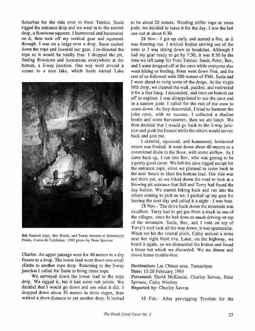
Suburban for the ride over to Pozo Tetrico. Susierigged the entrance drop and we went in to the seconddrop, a flowstone squeeze. I hammered and hammeredon it, then took off my vertical gear and squeezedthrough. I was on a ledge over a drop. Susie snakeddown the rope and lowered our gear. I re-directed therope so it would be totally free. I dropped the pit,finding flowstone and formations everywhere at thebottom, a 3-way junction. One way went around acorner to a nice lake, which Susie named Lake
Bill Gassiott (top), Bev Shade, and San<ly Henson at ~trawberry
Fields, Cueva de California. 1992 photo by Peter Sprouse
Charles. An upper passage went for 40 meters in a dryfissure to a drop. The lower lead went down two smallclimbs to another rope drop. Returning to the 3-wayjunction I called for Susie to bring more rope.
We surveyed down the lower lead to the ropedrop. We rigged it, but it had some rub points. Wedecided that I would go down and see what it did. Idropped down about 30 meters in three stages, thenwalked a short distance to yet another drop. It looked
to be about 20 meters. Needing stiffer rope or morepads, we decided to leave it for the day. I was the lastone out at about 6:30.
28 Nov.- I got up early and started a fire, as itwas freezing out. I noticed bodies stirring out of thetents as I was sitting down to breakfast. Although Ihad my gear ready to go by 7:30, it was 8:30 by thetime we left camp for Pozo Tetrico. Susie, Peter, Bev,and I were dropped off at the cave while everyone elsewent hiking or birding. Peter went down first, and therest of us followed with 200 meters of PM!. Susie andI went ahead to rerig some of the drops. At the virginfifth drop, we cleaned the wall, padded, and redirectedit for a free hang. I descended, and once on bottom setoff to explore. I was disappointed to see the cave endin a narrow joint. I called for the rest of the crew tocome down. As they descended, I tried to hammer thejoint open, with no success. I collected a rhadinebeetle and some harvestmen, then we ate lunch. Wethen decided that I would go back to the 3-way junction and push the fissure while the others would surveyback and join me.
I crawled, squeezed, and hammered; horizontalextent was limited. It went down about 40 meters to aconstricted drain in the floor, with some airflow. As Icame back up, I ran into Bev, who was getting to bea pretty good caver. We left the cave rigged except forthe entrance rope, since we planned to come back inthe near future to blast the bottom lead. Our ride wasnot there yet, so we hiked down the road to look at ablowing pit entrance that Bill and Terry had found theday before. We started hiking back and ran into theothers coming to pick us up. I packed up my gear forleaving the next day and called it a night - I was beat.
28 Nov. - The drive back down the mountain wasexcellent. Terry had to get gas from a truck in one ofthe villages, since he had done so much driving on topof the mountain. Susie, Bev, and I rode on top ofTerry's roof rack all the way down, it was spectacular.When we hit the coastal plain, Cathy noticed a noisenear her right front tire. Later, on the highway, weheard it again, so we dismantled the brakes and founda loose nut which we discarded. We ate dinner anddrove home trouble-free.
Destination: Las Chinas area, TamaulipasDate: 15-20 February 1993Personnel: David McKenzie, Charley Savvas, PeterSprouse, Cathy WinfreyReported by: Charley Savvas
15 Feb.- After pre-rigging Tecolote for the
The Death Coral Caver No. 3 27

upcoming expedition, we drove up the mountain toLas Chinas. We set up a nice camp in a sink by PozoTetrico. After camp was set, Peter and I decided to goblast the lead in the bottom of Tetrico, while Davidwent off looking for new entrances. Peter and I put onour new clean Wonderalls and Cathy took photos ofus.
We said goodbye to Cathy and rigged the Tetricoentrance drop. The next four drops were still riggedfron the November trip. The descent was quite swift,a half hour later we were placing our charge. We sataround the bend about 10 meters away. I used my REIheadlamp to set off the two 1-lb pouches. The shockwave was awesome. It immediately got smoky and westarted coughing. Peter put on his gear and started upthe rope pronto. I could hear him coughing on rope asI put on my ascending gear. I couldn't see a meter infront of me. When I heard Peter signal I wasted no
Bev Shade admires flowstone in Cueva de California. 1992 photoby Peter Sprouse
time in getting on rope. When we reached the top ofthe third drop the air was clear.
Returning to camp, we grabbed some more ropeand went off to check the blowing pit entrance locatedon the last trip. Peter rigged the pit, which he namedPozo Pozole, while Cathy and I waited on top. Afterawhile, I heard Peter yell "Come on down, bring morerope". No hesitation there, I got on rope and wentdown the nice 20-meter entrance drop, which thenoffset for another 10 meters. I found Peter gardeningthe lip of the third drop. He rappelled down and calledfor me to follow. The walls of this 25-meter drop werealmost completely covered with flowstone. When Iarrived I could hear Peter in a crawlway. I had a lookand found that it was a flowstone pinch. We climbedout of the cave and joined David back at camp arounda toasty campfire.
16 Feb.- David was up early to look for newcaves. Peter and I geared up for the survey of PowPozole, with Cathy going along on the surface. Wephotographed in and started the survey at the bottom.I hammered on a lead in the crawl but it didn't go. Sowe surveyed out, I was in the lead with tape andinstruments. The cave was about 60 meters deep.
We hiked back to camp for a snack and break,then about 5 pm went back into Pozo Tetrico to checkour blast from the night before. Rappelling the seriesof five drops was really enjoyable. A brief examination revealed that more blasting was needed. Settingoff another 1-lb pouch, we exited immediately, arriving back at camp to a crisp warm fire. David arrivedwith us, having found more pits for us to check.
17 Feb.- Peter and I planned to check our blastat the bottom of Pozo Tetrico. Before that we all tooka hike to look at some entrances that David had foundthe day before. One looked really good. On the wayback I found a nice pit, probably about 30 metersdeep. Peter and I entered Tetrico just after noon. Atthe bottom we dug and hammered awhile, gainingabout 10 meters. We finally gave up when the rift gotvery narrow, and started the de-rig. When I reachedthe top of the entrance drop, I called "off rope" toPeter and got a reply from Cathy, who had been a bitlost in the woods. Back at camp, we decided to checka small pit right in camp. I dropped the short entrancepit to a rubble slope. At the base of the slope I dug abit and opened up a pit, about 50 meters deep from thesound of it. Peter and Cathy joined me. Peter went ondown, prepared to set deviations. While we waited fornews from Peter, Cathy remarked on a small arch onthe wall by the rope, saying it looked kind of like ashrine, but missing its plastic Jesus. Therefore wenamed this cave Pozo Jesuplastico.
Peter Sprouse rappels into Pozo Tetrico. 1992 photo by SusieLasko
28 The Death Coral Caver No. 3
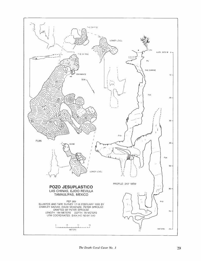
10
40
60
50
70
P24
ELEV 2575 M 0
I
fI
/ ,/ I
/ rI I
I II I
" 30I I
P5
P23
I ~
I '
I "I II I\ ..... I
PROFILE: 210° VIEW
POZO JESUPLASTICOLAS CHINAS, EJIDO REVILLA
TAMAULIPAS, MEXICO
PEP 269SUUNTOS AND TAPE SURVEY 17-18 FEBRUARY 993 BYCHARLEY SAWAS, DAVID MCKENZIE, PETER SPROUSE
DRAFTED BY PETER SPROUSELENGTH: 184 METERS DEPTH 78 METERS
UTM COORDINATES: E454,140 N2,641 ,540
PLAN
oI "
5 '0 15! , I ! I I
METERS
"
METERS 78
The Death Coral Caver No. 3 29
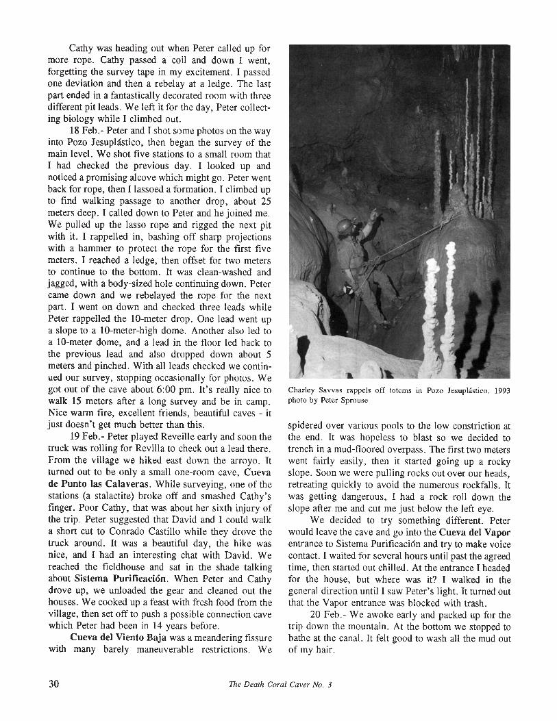
Cathy was heading out when Peter called up formore rope. Cathy passed a coil and down I went,forgetting the survey tape in my excitement. I passedone deviation and then a rebelay at a ledge. The lastpart ended in a fantastically decorated room with threedifferent pit leads. We left it for the day, Peter collecting biology while I climbed out.
18 Feb.- Peter and I shot some photos on the wayinto Pozo Jesuplastico, then began the survey of themain level. We shot five stations to a small room thatI had checked the previous day. I looked up andnoticed a promising alcove which might go. Peter wentback for rope, then I lassoed a formation. I climbed upto find walking passage to another drop, about 25meters deep. I called down to Peter and he joined me.We pulled up the lasso rope and rigged the next pitwith it. I rappelled in, bashing off sharp projectionswith a hammer to protect the rope for the first fivemeters. I reached a ledge, then offset for two metersto continue to the bottom. It was clean-washed andjagged, with a body-sized hole continuing down. Petercame down and we rebelayed the rope for the nextpart. I went on down and checked three leads whilePeter rappelled the lO-meter drop. One lead went upa slope to a lO-meter-high dome. Another also led toa lO-meter dome, and a lead in the floor led back tothe previous lead and also dropped down about 5meters and pinched. With all leads checked we continued our survey, stopping occasionally for photos. Wegot out of the cave about 6:00 pm. It's really nice towalk 15 meters after a long survey and be in camp.Nice warm fire, excellent friends, beautiful caves - itjust doesn't get much better than this.
19 Feb.- Peter played Reveille early and soon thetruck was rolling for Revilla to check out a lead there.From the village we hiked east down the arroyo. Itturned out to be only a small one-room cave, Cuevade Punto las Calaveras. While surveying, one of thestations (a stalactite) broke off and smashed Cathy'sfinger. Poor Cathy, that was about her sixth injury ofthe trip. Peter suggested that David and I could walka short cut to Conrado Castillo while they drove thetruck around. It was a beautiful day, the hike wasnice, and I had an interesting chat with David. Wereached the fieldhouse and sat in the shade talkingabout Sistema Purificaci6n. When Peter and Cathydrove up, we unloaded the gear and cleaned out thehouses. We cooked up a feast with fresh food from thevillage, then set off to push a possible connection cavewhich Peter had been in 14 years before.
Cueva del Viento Baja was a meandering fissurewith many barely maneuverable restrictions. We
Charley Savvas rappels off totems in Pozo Jesuphistico. 1993photo by Peter Sprouse
spidered over various pools to the low constriction atthe end. It was hopeless to blast so we decided totrench in a mud-floored overpass. The first two meterswent fairly easily, then it started going up a rockyslope. Soon we were pulling rocks out over our heads,retreating quickly to avoid the numerous rockfalls. Itwas getting dangerous, ! had a rock roll down theslope after me and cut me just below the left eye.
We decided to try something different. Peterwould leave the cave and go into the Cueva del Vaporentrance to Sistema Purificaci6n and try to make voicecontact. I waited for several hours until past the agreedtime, then started out chilled. At the entrance I headedfor the house, but where was it? I walked in thegeneral direction until I saw Peter's light. It turned outthat the Vapor entrance was blocked with trash.
20 Feb.- We awoke early and packed up for thetrip down the mountain. At the bottom we stopped tobathe at the canal. It felt good to wash all the mud outof my hair.
30 The Death Coral Caver No. 3

Destination: Cerro el Viejo, Zaragoza, Nuevo LoonDate: 20-25 May 1992Personnel: Michael Crawford, Susie Lasko, PeterSprouseReported by: Peter Sprouse
20 May- Michael Crawford, Susie, and I set offon a planned trip to Las Chinas. Drove south throughTexas in the rain.
21 May- We slogged to the base of the mountainsand found that the arroyo was flooding to 32 inchesdeep, too deep for an Isuzu Trooper. So we retreatedvia the Santa Engracia road, and were stopped againby a flooded crossing before we reached the pavement.Finally we were back at the highway and Cd. Victoria.We decided to head west through Linares Canyon andcamped near Cieneguillas.
22 May- We awoke to a crisp, clear highlandmorning. We drove on to Zaragoza and up to LaEscondida, where we arrived just in time for a karstcrack chicken rescue. We gave up on that quicklyenough when Cliofas Rosales (brother of our previousguide Jovito) offered to take us to a cave in a valleyjust to the east. Contrary to his grandiose claims, itappeared to be quite short. A number of pits werenearby, including one I'd seen in 1987. After settingup camp, Susie and I returned to the valley anddropped the 1987 lead, Pozo Repisa. Despite indications of drainage catchment, it filled 10 meters down.Susie found two more just up the valley flank to thesouth, and we picked the higher of the two to check.I dropped Pozo Cedro to find the bottom 18 metersdown.
Next we headed back to the road near camp, inthe vicinity of where it crests over from Zaragoza. Ina sink adjacent to Cueva de los Frijoles, we found asmall cave which we called Cueva Contacto. Whileonly 7 meters long, it did have a blowing pinch whichcould well lead to the breezy back of Frijoles. On theother (south) side of the road, we mapped a moreintriguing cave, Cueva Microsalamanquesa. Thissmall cave sloped north down the dip for 18 meters toa blowing pinch. This takes water but would beawkward to enlarge. Susie and I returned to camp afterdark to find Michael entertaining Cliofas and family.
23 May- Cliofas came by in the morning to guideus to pits. We went east up the valley from our campand over a rocky divide, from which we could see thecoastal plain away off to the east. On the 200 hectareswhich Cliofas owns are a number of pits, the first 3 ofwhich we passed on. Adjacent to his wheatfield was a7 meter wide, 6 meter deep pit with obvious passage
going off, so we dropped it. Unfortunately, Pozo delas Amapolas quickly ended. Above his field wasanother shaft about 15 meters deep which we didn'tdo, and below it in the arroyo was another, semiplugged. After that, we hopped back over to thedrainage to the north, downstream from Pozo Repisa.There we were shown Pozo del Calvario, whichlooked decent due to catchment. But again we foundthe end only 12 meters down. Hiking down the valleywe saw another good-looking pit, but passed on it tovisit yet another. This one, Pozo de Lucino, seemeddeeper and some cascading water could be heardbelow. We tied two lengths of KMIII together and Irappelled the first 30-meter pitch to the knot. Aftersome searching I found a thread to rebelay to andcontinued to the bottom, another 14 meters down.Here at -44 meters was a deep mud fill with a sawnlog mostly buried from a plunge. Michael came downand we surveyed out. On the way back west up thevalley, Cliofas showed us one Susie wanted to do,Pozo de la Mesita de Yerbanfz. A horizontal entranceled to a sloping drop. She ran out of rope 4 meters offthe floor, but it appeared blind. A sprinkle of rainaccompanied us back to camp. That evening we hostedCliofas and family for an Italian dinner.
24 May- We set off to the east to see some cavesnear Las Trojas, where Cliofas' brother Reymundolives. On the hike down the valley we saw severalshafts, and explored one. Pozo de la Rincon de laVfrgen was only 9 meters deep, but had looked goodon a steep bedding dip. The reputed cave at Las Trojasturned out to be nothing, but we did get to see somepits in the valley to the southeast. Out of six pits, wechose two. Pozo con Huevos was 19 meters deep andblind. Pozo de los Pateros was explored by Michaeldown two shafts to a depth of 64 meters. After that, itwas time for us to go. We hiked back to the trucksand bade farewell to our new friends. On the drivedown, we gave a ride to a schoolboy going to Zaragoza for the week's studies. We bathed at El Saito andate in town, then drove north through the rain toSaltillo, where we stayed in a hotel for the night.
25 May- Returned to Austin via Monclova andPiedras Negras.
Destination: Sierra Madre northwest of Cd. Victoria.Date: 7-15 May 1977Personnel: Ralph Batsche, Mike Connolly, CarminaGaither, Charles Fromen, Peter Sprouse, Terri Treacy,Harry Walker.Reported by: Charles Fromen
The Dealh Coral Caver No. 3 31
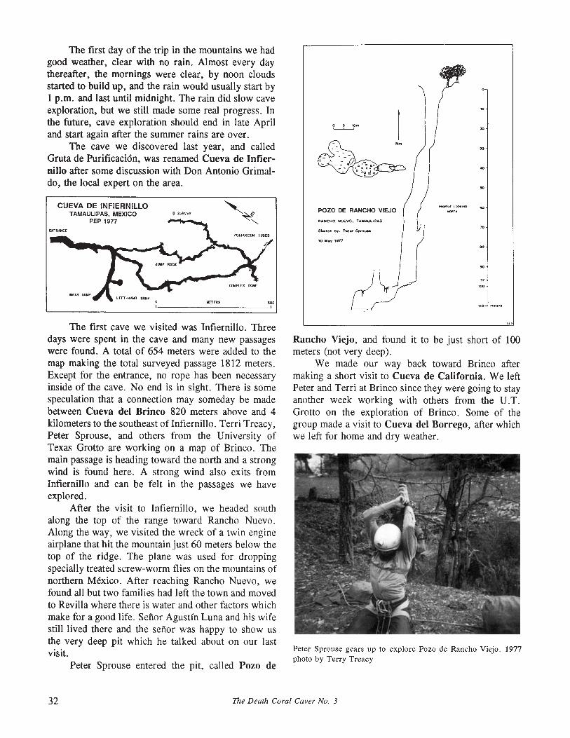
The first day of the trip in the mountains we hadgood weather. clear with no rain. Almost every daythereafter. the mornings were clear. by noon cloudsstarted to build up, and the rain would usually start by1 p.m. and last until midnight. The rain did slow caveexploration, but we still made some real progress. Inthe future, cave exploration should end in late Apriland start again after the summer rains are over.
The cave we discovered last year, and calledGruta de Purificaci6n, was renamed Cueva de Infiernillo after some discussion with Don Antonio Grimaldo, the local expert on the area.
CUEVA DE INFIERNILLOTAMAULIPAS, MEXICO
PEP 1977o SURVEY
UfTERS "'",
o 5 10'"~
POZO DE RANCHO VIEJO
RANCHO NUEVO. TAMAUllPAS
Sketch by: P.t.r Sprouse
10 'hy 1S177
The first cave we visited was Infiernillo. Threedays were spent in the cave and many new passageswere found. A total of 654 meters were added to themap making the total surveyed passage 1812 meters.Except for the entrance, no rope has been necessaryinside of the cave. No end is in sight. There is somespeculation that a connection may someday be madebetween Cueva del Brinco 820 meters above and 4kilometers to the southeast of Infiernill0 . Terri Treacy,Peter Sprouse, and others from the University ofTexas Grotto are working on a map of Brinco. Themain passage is heading toward the north and a strongwind is found here. A strong wind also exits fromInfiernillo and can be felt in the passages we haveexplored.
After the visit to Infiernillo, we headed southalong the top of the range toward Rancho Nuevo.Along the way, we visited the wreck of a twin engineairplane that hit the mountain just 60 meters below thetop of the ridge. The plane was used for droppingspecially treated screw-worm flies on the mountains ofnorthern Mexico. After reaching Rancho Nuevo, wefound all but two families had left the town and movedto Revilla where there is water and other factors whichmake for a good life. Senor Agustin Luna and his wifestill lived there and the senor was happy to show usthe very deep pit which he talked about on our lastvisit.
Peter Sprouse entered the pit, called Pozo de
Rancho Viejo, and found it to be just short of 100meters (not very deep).
We made our way back toward Brinco aftermaking a short visit to Cueva de California. We leftPeter and Terri at Brinco since they were going to stayanother week working with others from the U.T.Grotto on the exploration of Brinco. Some of thegroup made a visit to Cueva del Borrego, after whichwe left for home and dry weather.
Peter Sprouse gears up to explore Pozo de Rancho Viejo. 1977photo by Terry Treacy
32 The Death Coral Caver No. 3