the development and validation of a prototype mobility
TRANSCRIPT

RESEARCH ARTICLE Open Access
The development and validation of aprototype mobility tracker for assessing thelife space mobility and activity participationof older adultsSoon Hoe Ho1†, Dion Piu Sern Tan2†, Pey June Tan1, Ka Wei Ng2, Zoe Zon Be Lim1, Isabel Hui Leng Ng1,Lok Hang Wong1, Mimaika Luluina Ginting1, Belinda Yuen3, Ullal Jagadish Mallya4, Mei Sian Chong1,5 andChek Hooi Wong1,4,6*
Abstract
Background: There is increasing interest in examining the life space mobility and activity participation of olderadults in the community using sensor technology. Objective data from these technologies may overcome thelimitations of self-reported surveys especially in older adults with age-associated cognitive impairment. This paperdescribes the development and validation of a prototype hybrid mobility tracker for assessing life space mobilityand out-of-home activities amongst 33 community-ambulant older adults in Singapore.
Methods: A hybrid mobility tracker was developed by combining a passive Global Positioning System logger, tri-axial accelerometer and radio-frequency identification. Objective measures of life space, derived from 1 week oftracking data using Geographic Information Systems, were the maximum Euclidean distance from home (MaxEuclid) and the area of the minimum convex polygon surrounding all GPS waypoints (MCP area). Out-of-homeactivities were quantified by visually identifying the total number of activity nodes, or places where participantsspent ≥5 min, from mobility tracks. Self-reported measure of life space in 4 weeks was obtained using theUniversity of Alabama at Birmingham Study of Life Space Assessment (UAB-LSA) questionnaire. Self-reported out-of-home activities were recorded daily in a travel diary for 1 week. Bivariate correlations were used to examineconvergent validity between objective and subjective measures of life space and out-of-home activities.
Results: The mean age of participants was 69.2 ± 7.1 years. The mean UAB-LSA total score was 79.1 ± 17.4. Themedian (range) Max Euclid was 2.44 km (0.26–7.50) per day, and the median (range) MCP area was 3.31 km2 (0.03–34.23) per day. The UAB-LSA total score had good correlation with Max Euclid (r = 0.51, p = 0.002), and moderatecorrelation with MCP area (r = 0.46, p = 0.007). The median (range) total number of activity nodes measured by(Continued on next page)
© The Author(s). 2020 Open Access This article is licensed under a Creative Commons Attribution 4.0 International License,which permits use, sharing, adaptation, distribution and reproduction in any medium or format, as long as you giveappropriate credit to the original author(s) and the source, provide a link to the Creative Commons licence, and indicate ifchanges were made. The images or other third party material in this article are included in the article's Creative Commonslicence, unless indicated otherwise in a credit line to the material. If material is not included in the article's Creative Commonslicence and your intended use is not permitted by statutory regulation or exceeds the permitted use, you will need to obtainpermission directly from the copyright holder. To view a copy of this licence, visit http://creativecommons.org/licenses/by/4.0/.The Creative Commons Public Domain Dedication waiver (http://creativecommons.org/publicdomain/zero/1.0/) applies to thedata made available in this article, unless otherwise stated in a credit line to the data.
* Correspondence: [email protected]†Soon Hoe Ho and Dion Piu Sern Tan are co-first authors.1Geriatric Education and Research Institute Ltd, 2 Yishun Central 2, Singapore768024, Singapore4Department of Geriatric Medicine, Khoo Teck Puat Hospital, 90 YishunCentral, Singapore 768828, SingaporeFull list of author information is available at the end of the article
Ho et al. BMC Geriatrics (2020) 20:251 https://doi.org/10.1186/s12877-020-01649-x

(Continued from previous page)
tracker of 20 (8–47) per week had a good correlation with the total activity count recorded in the travel diaries of15 (6–40) per week (r = 0.52, p = 0.002).
Conclusions: The tracking system developed to understand out-of-home travel was feasible and reliable.Comparisons with the UAB-LSA and travel diaries showed that it provided reliable and valid spatiotemporal data toassess the life space mobility and activity participation of older adults.
Keywords: Mobility tracker, Global positioning system, Radio-frequency identification, Accelerometer, Life space
BackgroundThe concept of life space refers to the geographic extentwithin which an individual lives and moves. It is aninteraction between the individual and the physicalenvironment, determined by the individual’s mobilityand other intrinsic capacities, as well as environmentalfactors in either enabling or restricting such interactions[1–3]. In the context of ageing, a progressive decline ofphysical, functional and cognitive health limits an indi-vidual’s ability to overcome environmental constraintsfor mobility, thus constricting the life spaces of olderadults and often leaving them more confined to theirlocal neighbourhoods compared to people in other agegroups [1, 3–5]. Studying the changes in older people’slife space mobility, therefore, renders valuable informa-tion for the understanding of their person-environmentinteractions within the real world and the community.To date, the measurement of life space mobility is
largely dependent on self-reported time-space traveland activity diaries. However, the accuracy of self-reported measures is limited by the user’s capacity torecord their activities reliably [6, 7]. This presents achallenge particularly to older users who are at higherrisk of cognitive impairment [8, 9]. In recent years, avariety of sensors have been developed to gather object-ive data on human mobility, including Radio-FrequencyIdentification technology (RFID), the Global PositioningSystem (GPS) and accelerometers, each having its ownadvantages and limitations [10].The use of RFID and GPS is gaining popularity in health
research seeking to uncover the relationships betweengeographical location and various health outcomes. WhilstRFID offers portability, with its tags easily tucked away inpockets or bags [9], its accuracy is dependent on the num-ber of readers placed within a limited area for tracking.This makes studying a larger area difficult and costlier, asa large number of readers is required [9, 11]. GPS, on theother hand, is able to track locations over large areas onthe earth using satellites [9]. The accuracy of spatial coor-dinates, however, depends on the reception of satellite sig-nals of sufficient quality as signals could be obstructed bysolid walls and structures such as in the underground, orby atmospheric conditions and electromagnetic waves.Nevertheless, GPS offers researchers the opportunity for
continuous and intensive high-resolution data collectionin time and space over long durations [12, 13]. In contrastto RFID and GPS, accelerometers do not capture spatialdata. They detect acceleration and have been widely usedin health studies to measure walking speeds, posturalchanges and other body movements [10].In this study, we developed a hybrid system by
combining these three technologies (GPS, accelerometerand RFID) for tracking the outdoor mobility and activityparticipation of older adults with no self-reported historyof dementia within their life spaces for 1 week. Threetechnologies were used to counteract the limitations of asingle technology, and a design-thinking approach wasused to create a prototype mobility tracker that suits themobility and usage patterns of older adults. The trackerwas developed as a prototype in a national level projecton planning and design of age-friendly neighbourhoodsin Singapore. One of the aims of that larger project wasto understand the daily habitual outdoor movementsand activity patterns of older adults.The paper describes the development of the prototype
hybrid mobility tracker and systematically compares object-ive data from the tracker to self-reported measures to assessits validity and reliability in measuring life-space mobilityand out-of-home activities in community-dwelling olderadults. Convergent validity was established from bivariatecorrelations between objective measures of life-space mo-bility and out-of-home activities obtained from the mobilitytracker, and subjective data obtained from the self-reportedUniversity of Alabama at Birmingham Study of AgingLife Space Assessment (UAB-LSA) [1, 2] and traveldiaries [14, 15]. We also present a case study of usingthe tracker for 1 week in an older adult without demen-tia to demonstrate the tracker’s feasibility and validity.
MethodsTarget research populationThis was a prospective study based on cross-sectional de-sign. The study recruited adults aged 55 years and abovewho were able to mobilise independently for a distance ofapproximately two bus stops (400m), able to leave homeat least once a week and had no self-reported history ofdementia. A total of 33 community-dwelling older adultswere recruited through a convenience sampling approach
Ho et al. BMC Geriatrics (2020) 20:251 Page 2 of 12

in community centres, senior care centres and senior ac-tivity centres in three neighbourhoods located in the west-ern, central and eastern regions of Singapore from Januaryto June 2018. Potential participants were invited to a face-to-face interview with members of the research team tounderstand the study components and provide informedconsent before participating. The study was approved bythe National Healthcare Group’s Domain Specific ReviewBoard.
Data collectionBaseline assessmentBaseline sociodemographic characteristics, includingcognitive status based on the Mini-Mental State Examin-ation (MMSE) [16], were collected through face-to-faceinterviews by a trained researcher in participants’ homesusing their preferred language (English, Malay, or Mandarin).The Malay and Mandarin versions of the MMSE question-naire were developed by forward- and backward-translationsof the English questionnaire by independent translators.
Subjective life space and activity participation (UAB-LSAand travel diaries)Life space mobility was measured at baseline using theUniversity of Alabama at Birmingham Study of AgingLife Space Assessment questionnaire (UAB-LSA) [1, 2].The UAB-LSA provides a total score accounting for (a)life space level reached in the past 4 weeks, where ahigher level denotes a farther distance from home; (b)the frequency of travel; and (c) the level of mobilityindependence during the travel. A higher total score cor-responds to a larger life space [1, 2]. The survey was ad-ministered by a trained researcher in participants’ homesusing their preferred language (English, Malay, or Man-darin). The Malay and Mandarin versions were
developed by forward- and backward-translations of theEnglish questionnaire by independent translators.Activity participation was tracked daily for 1 week, by
using travel diaries with daily entries of the weather,places visited, time of visit, mode of transport and typesof activities participated.
Objective life space and activity participation (prototypemobility tracker)Participants were given a pocket-sized mobility trackerto be carried out-of-home every day for 1 week. Lifespace mobility was derived from the tracking data usingtwo measures: (a) area of the minimum convex polygon(abbreviated MCP area) around all GPS waypoints, and(b) maximum Euclidean distance from home (abbrevi-ated Max Euclid) [17].Activity participation was estimated by identifying
“activity nodes”, which were the significant places whereparticipants had stopped for 5 minutes or more [9, 18].Activity nodes were visually identified from the mobilitytracks during the processing of raw GPS data.
Development of the prototype mobility trackerFig. 1 illustrates the study flow from conceptualisationand development of the prototype mobility tracker to itsvalidation.
Design considerationsThe prototype was developed in consultation with geria-tricians, engineers and researchers in the fields of aged-care and mobility. Prototype design considerations andhardware requirements are summarised in Table 1.
Fig. 1 Study flow diagram
Ho et al. BMC Geriatrics (2020) 20:251 Page 3 of 12

Development and pilot testing for acceptability of GPSloggers and RFID systemUser feedback surveys were conducted in volunteersaged ≥55 years during prototype development to under-stand the acceptability and usability of several wearablemobility tracker designs. Pilot testing of two differentGPS loggers and the RFID system was conducted in twovolunteers (aged 66 and 67 years old) for 3 days beforefinalising the prototype mobility tracker.
Final deviceThe device consisted of an encased GPS logger andaccelerometer, whilst the RFID tag was located exter-nally for better sensitivity. It did not have a displayscreen in order to prevent participants from trackingtheir own activity, hence limiting cognitive bias. A hardcasing was designed to protect the GPS logger and accel-erometer from accidental tampering (Fig. 2).The GPS logger was a passive logger which did not
transmit any data (iTrail H6000 GPS logger) [20].Instead, data was saved in its internal memory anddownloaded for processing before being viewed on amapping program (i.e. Google Maps). The accelerometerhad a sampling rate of 12.5 Hz (i.e. capturing data 12.5times every second) (Axivity AX3 3-axis logging acceler-ometer) [21]. It integrated the acceleration experiencedin three coordinate axes to give an overall acceleration.A Python program was developed to calculate the num-ber of steps and walking speed from the accelerometer’sraw data [22, 23]. More detailed description is availablein the supplementary material [see Additional file 1].The RFID system had a read range of three metres.
The RFID reader (KL9001R) [24] was placed at the maindoor of participants’ homes at waist or shoulder level.Participants were instructed to place the RFID tag insidea pouch with a carabiner or a keychain. Each RFID tagwas labelled with a unique identification number (ID) toallow for the tracking of multiple participants from thesame home. A five-minute time difference was set foreach RFID tag to prevent the detection of false positiveswhenever participants left their homes for less than 5minutes (i.e. not considered an outdoor trip). The RFIDsystem detected when the participant left and returnedhome. To improve adherence and ensure that partici-pants remembered to bring the device whenever theytravelled outside of home, reminder posters were placedat prominent positions near home entrances.As a re-chargeable device was deemed unsuitable for
older adults (who may forget to charge the device), thedevice was designed for a maximum battery life span of4–5 days. In addition, the GPS logger was able to con-serve its battery life by powering off when no motionwas detected for 5 minutes. As such, the research teamhad to visit the homes of the participants only once (i.e.
Table 1 Design considerations of the prototype mobility tracker
Hardware requirements
• The system should incorporate:
Passive radio-frequency identification (RFID) device or equivalent
o To accurately detect when the user leaves and arrives home.
o RFID reader should have algorithms to prevent false positives.
Global Positioning System (GPS) logger or equivalent
o To collect geospatial location and outdoor travel data every second.
o Accuracy of at least 10 m.
o Should be able to lock GPS position from cold start in less than 1 min.
o Should be able to record distance and travel speed to decode travelmode.
Accelerometer or equivalent
o To validate GPS data and track movement out of home where GPSsignal is unavailable.
o The device should have a sampling rate that would enable it todetect falls as an adverse event (typically 5–8 Hz).
Data output requirements:
• The system should accurately track the following indicators:
o Type of travel mode (i.e. walking, vehicular).
o Time spent per travel mode (per day).
o Total distance travelled from home (per day).
o Total distance travelled per travel mode (per day).
o No. of walking tracks (per day) (walking track identified by speed ≤5km/h) [18, 19].
o No. of steps (per day).
o Time spent out of home (per day).
o Time spent in location (per location per day).
o Location (latitude and longitude in SVY21 projection).
o No. of activity nodes (per day) (defined as places participants stayedfor ≥5 min [9, 18].
• Spatial format in latitude, longitude and fixed projection.
• Retrieved location data should be exportable for geospatial mapping.
• Retrieved walking data should be exportable in commonly used dataformats.
Older adult-customised design/feasibility requirements
• The tracker should operate without additional input from users.
• The tracker should be durable and resistant to adverse weatherconditions.
• The tracker should be small, lightweight, and non-intrusive ordistractive.
• The tracker should be safe to operate and socially acceptable to olderadults.
Reliability requirements:
• The RFID reader should last continuously for at least 7 days.
• The system should require minimal training to operate.
Ho et al. BMC Geriatrics (2020) 20:251 Page 4 of 12

midway during the week-long data collection period) toexchange their existing device with another fully-charged device. This was to ensure that participantswould always carry devices with sufficient battery powerat all times. Raw data from the tracking system wereprocessed and presented per participant per day, whichwere used for further analysis.
Data analysesSpatial data was derived using a Geographic InformationSystem (GIS), QGIS version 2.18.13 [25]. Quantitativestatistical analyses were performed on R version 3.3.1[26]. Parametric data were reported as mean and stand-ard deviation, whilst non-parametric data were reportedas median and range. Convergent validity was assessedbetween objective and subjective measures of life spaceand activity participation, using bivariate correlationsbetween the UAB-LSA Total score (LSA Total) andmaximum Euclidean distance from home (Max Euclid),between LSA Total and the area of the minimum convexpolygon surrounding all GPS waypoints (MCP area), andbetween the number of activity nodes detected from themobility tracker and the number of activities recorded inthe travel diary [14, 15]. Non-parametric Spearman rankcorrelation was used as variables were not normallydistributed using Shapiro-Wilk test [15, 27]. Spearmancorrelation coefficients of 0.25–0.50 were moderate,0.50–0.75 good, and > 0.75 excellent [15, 28]. The mini-mum sample size to detect a correlation coefficient of0.50 with 80% power at two-tailed 5% is 29 [15, 29].Statistical significance was taken as p ≤ 0.05.
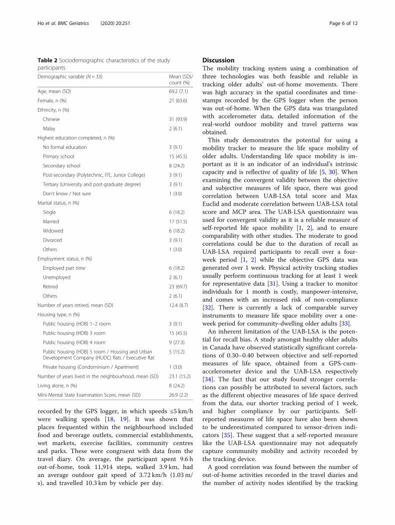
ResultsParticipants’ sociodemographic characteristicsThirty-three older adults completed the study. The meanage of the participants was 69.2 years (SD 7.1 years;range = 56–84 years), and 21 were women (63.6%). Halfof the participants (45.5%) had primary-level education(i.e., 6 years or less of formal education). Seventeen(51.5%) individuals were married and two-thirds (69.7%)
were retired with a mean retirement duration of 12.4years. Eight individuals (24.2%) lived alone. The meanMMSE score was 26.9 (SD 2.2; range = 21–30) (Table 2).
Life space mobility and activity participationThe total number of participant-days recorded in the 33travel diaries was 215 days, which was 98.6% of the totalnumber of participant-days tracked by the mobilitytracker (218 days) (Table 3). Activities recorded in thetravel diaries include active leisure, attending educationalcourses, grocery shopping, and dining out. No partici-pant reported any difficulty in using the mobility track-ing device.Bivariate plots between objective and subjective mea-
sures of life space and outdoor activities are shown inFig. 3. The mean UAB-LSA total score was 79.1 ± 17.4.Participants travelled from home a median (range) MaxEuclid of 2.44 km (0.26–7.50) per day. The median(range) MCP area was 3.31 km2 (0.03–34.23) per day.Participants’ UAB-LSA total scores had a good correl-ation with their average daily Max Euclid (r = 0.51, p =0.002). The correlation of their UAB-LSA total scoreswith their average daily MCP area was moderate (r =0.46, p = 0.007).For out-of-home activities, the median (range) total
number of activity nodes measured by the tracker was20 (8–47) per week, and the median (range) total activitycount recorded by travel diaries was 15 (6–40) per week.The total number of activity nodes per week detected bythe mobility tracker had a good correlation with thetotal number of activities recorded in the travel diary(r = 0.52, p = 0.002).
DemonstrationCase study: detailed travel mobility and activity of oneparticipant for 1 weekThe detailed travel mobility and activity of one partici-pant to demonstrate the use of the prototype mobilitytracker in a real world setting is presented in Table 4.The mode of travel was inferred from the speed
Fig. 2 Casing containing GPS logger and accelerometer (left); back sliding cover for insertion of accelerometer (right)
Ho et al. BMC Geriatrics (2020) 20:251 Page 5 of 12
recorded by the GPS logger, in which speeds ≤5 km/hwere walking speeds [18, 19]. It was shown thatplaces frequented within the neighbourhood includedfood and beverage outlets, commercial establishments,wet markets, exercise facilities, community centresand parks. These were congruent with data from thetravel diary. On average, the participant spent 9.6 hout-of-home, took 11,914 steps, walked 3.9 km, hadan average outdoor gait speed of 3.72 km/h (1.03 m/s), and travelled 10.3 km by vehicle per day.
DiscussionThe mobility tracking system using a combination ofthree technologies was both feasible and reliable intracking older adults’ out-of-home movements. Therewas high accuracy in the spatial coordinates and time-stamps recorded by the GPS logger when the personwas out-of-home. When the GPS data was triangulatedwith accelerometer data, detailed information of thereal-world outdoor mobility and travel patterns wasobtained.This study demonstrates the potential for using a
mobility tracker to measure the life space mobility ofolder adults. Understanding life space mobility is im-portant as it is an indicator of an individual’s intrinsiccapacity and is reflective of quality of life [5, 30]. Whenexamining the convergent validity between the objectiveand subjective measures of life space, there was goodcorrelation between UAB-LSA total score and MaxEuclid and moderate correlation between UAB-LSA totalscore and MCP area. The UAB-LSA questionnaire wasused for convergent validity as it is a reliable measure ofself-reported life space mobility [1, 2], and to ensurecomparability with other studies. The moderate to goodcorrelations could be due to the duration of recall asUAB-LSA required participants to recall over a four-week period [1, 2] while the objective GPS data wasgenerated over 1 week. Physical activity tracking studiesusually perform continuous tracking for at least 1 weekfor representative data [31]. Using a tracker to monitorindividuals for 1 month is costly, manpower-intensive,and comes with an increased risk of non-compliance[32]. There is currently a lack of comparable surveyinstruments to measure life space mobility over a one-week period for community-dwelling older adults [33].An inherent limitation of the UAB-LSA is the poten-
tial for recall bias. A study amongst healthy older adultsin Canada have observed statistically significant correla-tions of 0.30–0.40 between objective and self-reportedmeasures of life space, obtained from a GPS-cum-accelerometer device and the UAB-LSA respectively[34]. The fact that our study found stronger correla-tions can possibly be attributed to several factors, suchas the different objective measures of life space derivedfrom the data, our shorter tracking period of 1 week,and higher compliance by our participants. Self-reported measures of life space have also been shownto be underestimated compared to sensor-driven indi-cators [35]. These suggest that a self-reported measurelike the UAB-LSA questionnaire may not adequatelycapture community mobility and activity recorded bythe tracking device.A good correlation was found between the number of
out-of-home activities recorded in the travel diaries andthe number of activity nodes identified by the tracking
Table 2 Sociodemographic characteristics of the studyparticipants
Demographic variable (N = 33) Mean (SD)/count (%)
Age, mean (SD) 69.2 (7.1)
Female, n (%) 21 (63.6)
Ethnicity, n (%)
Chinese 31 (93.9)
Malay 2 (6.1)
Highest education completed, n (%)
No formal education 3 (9.1)
Primary school 15 (45.5)
Secondary school 8 (24.2)
Post-secondary (Polytechnic, ITE, Junior College) 3 (9.1)
Tertiary (University and post-graduate degree) 3 (9.1)
Don’t know / Not sure 1 (3.0)
Marital status, n (%)
Single 6 (18.2)
Married 17 (51.5)
Widowed 6 (18.2)
Divorced 3 (9.1)
Others 1 (3.0)
Employment status, n (%)
Employed part time 6 (18.2)
Unemployed 2 (6.1)
Retired 23 (69.7)
Others 2 (6.1)
Number of years retired, mean (SD) 12.4 (8.7)
Housing type, n (%)
Public housing (HDB) 1–2 room 3 (9.1)
Public housing (HDB) 3 room 15 (45.5)
Public housing (HDB) 4 room 9 (27.3)
Public housing (HDB) 5 room / Housing and UrbanDevelopment Company (HUDC) flats / Executive flat
5 (15.2)
Private housing (Condominium / Apartment) 1 (3.0)
Number of years lived in the neighbourhood, mean (SD) 23.1 (15.2)
Living alone, n (%) 8 (24.2)
Mini-Mental State Examination Score, mean (SD) 26.9 (2.2)
Ho et al. BMC Geriatrics (2020) 20:251 Page 6 of 12

device. This study provides quantitative evidence of thefeasibility of a GPS-enabled tracking device to capturemore instances of destinations for activities compared tothat reported in the travel diaries. However, the data alsoshows evidence of a gap in the number of activities un-reported in travel diaries but detected by the mobilitytracker. It was suggested that some destinations are per-ceived as more relevant or significant by older adultsdue to characteristics like purpose of trip, variety andavailability of resources, and may be more likely to berecorded in self-reported diaries, which should beexplored in future research [36, 37]. Other discrepanciesbetween travel diaries and objective sources like GPStracking have been attributed to trip “chaining” whereindividuals lump several short trips into one, and thetendency to record round numbers [38]. Whilst bothtools are equally useful for understanding the outdooractivities of individuals, each has its strengths and limita-tions. Travel diaries document the types of activitiesperformed and other qualitative information which areunavailable from the mobility tracker. On the otherhand, information from the tracker is more accuratespatially and objectively with no recall bias.None of our participants experienced any problem
with the mobility tracker. While mild cognitive impair-ment might affect the complexity of travel, it did nothinder any participant from using the mobility trackeroutside the home. There are several advantages in usingthe mobility tracker to study the life space and activityparticipation of older adults. Firstly, it overcomes thelimitation of recall bias as experienced in the use of asurvey instrument. Secondly, the measure of life spaceis not subjected to individual perceptions of whatconstitutes the “neighbourhood” and “town”, which isrequired for survey instruments in defining different lifespace levels. The objective distance-based measure oflife space directly removes the need to differentiate“neighbourhood” from “town”, which might have differ-ent meanings for different people, and for those livingin urban or rural settings [39]. This problem would lead
to inferential biases, hence life space measures based onthe UAB-LSA may not be generalizable across studiesfrom different rural or urban centres and countries[40]. Thirdly, the objective data analysed on GIS enableddetailed visualization and quantification of out-of-homemovement and travel to increase the understanding ofspatiotemporal behaviour of older adults in their environ-ment, hence providing valuable insight to ageing researchon person-environment interactions [4].The development and design of a mobility tracking
system demands a user-centric approach. In our study,end-user surveys were administered to understand theacceptability and usability of different wearable mobilitytracker designs amongst older adults, in order to in-crease compliance with wearing a tracking device. Oneadditional consideration during the design process wasthe battery life of the device. A long battery life was es-pecially important to allow the use of such devices inolder adults with cognitive impairment [8].Modern digital sensing technologies open up new ways
to understand human mobility, allowing for a linkage ofthat information with location and other geographicinformation. They offer real-time objective readings ofindividual mobility as compared to survey instruments,travel diaries, and interviews, and are usually moreaccurate and granular than the latter methods [2, 41].When entered into a spatial analysis program like GIS,they extend our understanding of space and time usageby individuals at various locations in greater detail [42].Using these technologies in cities like Singapore,however, is not without limitations. For instance, GPSloggers are unable to access radio waves from orbitingsatellites inside buildings or the underground. In conse-quence, there could be gaps in spatial coordinates whenusers travel in underground trains, for example.Advanced technologies, though useful in mapping out-of-home mobility and locations, do not fully replacequestionnaires, diaries or interviews, which remain im-portant methods to gather in-depth information aboutolder adults’ travel behaviour and outdoor activities.
Table 3 Life space mobility and activity participation of study participants in one weeka
Measure of life space extent (N = 33) Data source Mean (SD)/ Median (range)
Max Euclid per day (km), median (range) Mobility tracker 2.44 (0.26–7.50)
MCP area per day (km2), median (range) Mobility tracker 3.31 (0.03–34.23)
UAB-LSA total score (maximum score 120), mean (SD) Questionnaire 79.1 (17.4)
Activity participation (N = 33) Data source Mean (SD)/ Median (range)
Total number of activity nodes per week, median (range) Mobility tracker 20 (8–47)
Total number of activities per week, median (range) Travel diary 15 (6–40)
Average time spent per activity node (minutes), median (range) Mobility tracker 46.59 (26.20–259.00)a Data is reported as mean (SD) if normally distributed, and median (range) if not normally distributed, based on the Shapiro-Wilk test. Legend: MCP Area Area ofthe minimum convex polygon around all GPS waypoints, Max Euclid Maximum Euclidean distance from home, UAB-LSA University of Alabama at BirminghamStudy of Aging Life Space Assessment
Ho et al. BMC Geriatrics (2020) 20:251 Page 7 of 12

Fig. 3 Relationships between objective and subjective measures of life space mobility and activity participation
Table 4 Travel record of a participant for one week
Day Place TravelMode
RFID ReachHomeTime
RFID LeaveHomeTime
Walkingdistance (km)
Speed(km/h)
Total Vehicle TravelDistance (km)
Time Spent outof Home (s)
Total Numberof Steps
1 Home – – 11:40 2.7 3.3 – 19,626 7854
CCa Walk
RCb Walk
Home Walk 17:07
2 Home – – 6:13 6.4 3.53 – 42,661 16,648
Housing Block Walk
Ho et al. BMC Geriatrics (2020) 20:251 Page 8 of 12

Table 4 Travel record of a participant for one week (Continued)
Day Place TravelMode
RFID ReachHomeTime
RFID LeaveHomeTime
Walkingdistance (km)
Speed(km/h)
Total Vehicle TravelDistance (km)
Time Spent outof Home (s)
Total Numberof Steps
Home 7:40 7:55
Housing Block Walk
RCb Walk
CCa Walk
Stadium Walk
Town Centre Walk
Home Walk 18:20 –
3 Home – – 6:15 3.8 3.02 51.3 56,019 14,197
Stadium Walk
Housing Block Walk
RCb Walk
MRTc Vehicle
Shopping centre Vehicle
Housing Block Vehicle
Supermarket Vehicle
Town Centre Vehicle
Home Vehicle 21:49 –
4 Home – – 7:15 6.6 3.96 – 32,393 17,842
RCb Walk
Market Walk 7:55 9:27
Association Walk
Home Walk 11:44 13:04
Housing Block Walk
Housing Block Walk
Stadium Walk
Sports Complex Walk
Home Walk 17:35 –
5 Home – – 6:22 1.9 4.12 8.9 30,150 7559
Housing Block Walk
Housing Block Walk
Home Walk 8:27 11:32
RCb Walk
Relative’s House Vehicle
6 Relative’s House – 2.3 4.0 12 34,820 6616
Green Park Walk
Housing Block Walk
Housing Block Walk
RCb Walk
Home Walk 17:45 –
7 Home – – 11:13 3.5 4.13 – 25,266 12,684
RCb Walk
Housing Block Walk
Home Walk 16:08 17:11
Ho et al. BMC Geriatrics (2020) 20:251 Page 9 of 12

ConclusionThis is, to our knowledge, the first prototype hybridmobility tracking system comprising of a GPS logger, anaccelerometer, and RFID that was developed for measur-ing the life space, mobility and activity participation ofcommunity-dwelling older adults. This study establishesits validity and reliability, with moderate to good correla-tions between objective tracking data and the self-reported life space and activities reported in the UAB-LSA questionnaire and travel diaries. We found that ob-jective data provided better quantification of the multidi-mensional aspects of life space extent and out-of-homeactivities compared to the subjective methods as it is lessprone to recall bias. When supplemented with traveldiaries and a life space questionnaire, one would gain aricher understanding of older adults’ travel and activitypatterns outside the home. Therefore, future communityoutdoor mobility studies could employ both objectiveand subjective methods to gather in-depth informationon individual travel patterns and behaviour. As the trendin global aging increases, a better understanding of olderpersons’ outdoor mobility could help in tailoring pro-grammes and city planning toward the needs of olderadults [3, 43, 44].
Supplementary informationSupplementary information accompanies this paper at https://doi.org/10.1186/s12877-020-01649-x.
Additional file 1. Description of the algorithms to calculate steps andwalking speed. A brief description of the algorithms used to calculate thenumber of steps and walking speed of the participants from the rawaccelerometer data. Two diagrams are included for illustration.
AbbreviationsGPS: Global Positioning System; GIS: Geographic Information Systems; UAB-LSA: University of Alabama at Birmingham Study of Aging Life SpaceAssessment; RFID: Radio-frequency identification; Max Euclid: MaximumEuclidean distance from home; MCP area: Area of the minimum convexpolygon; LSA Total: UAB-LSA total score
AcknowledgementsThe authors wish to thank all participants who had contributed time andefforts to this research. They acknowledge Singapore University ofTechnology and Design, Geriatric Education and Research Institute Ltd.,Urban Redevelopment Authority, Agency for Integrated Care, Building andConstruction Authority, Housing and Development Board, Ministry of HealthSingapore, Lekker Architects Pte Ltd., Tierra Design Studio Pte Ltd., CPG
Consultants Pte Ltd., Alexandra Health Pte Ltd., AIM & Associates, and NDRMedical Technology Pte Ltd. as partners and collaborators in this study.
Authors’ contributionsSHH contributed to the research, data analysis and manuscript; DPST andKWN developed the prototype mobility tracker, generated and analysed theraw data, and contributed to the manuscript; PJT designed and conductedthe research, analysed the data and contributed to the manuscript; ZZBLcontributed to the manuscript; IHLN, LHW, and MLG designed andconducted the research, and analysed the data; BY provided direction to theresearch; MUJ and MSC provided opinion on the research and commentedon the manuscript; CHW designed and supervised the research, andcontributed to the manuscript. The authors have read and approved themanuscript.
FundingThis material is based on research/work supported by Singapore’s Ministry ofNational Development and National Research Foundation under the Landand Liveability National Innovation Challenge Funding Programme (grantnumber L2NICTDF1–2017-2). Any opinions, findings, and conclusions orrecommendations expressed in this material are those of the authors and donot reflect the views of Singapore’s Ministry of National Development,National Research Foundation or any of the agency collaborators. The grantfunders were not involved in the design of the study, the collection, analysisand interpretation of data, and in writing the manuscript.
Availability of data and materialsThe raw datasets generated and/or analysed during the current study arenot publicly available due to a confidentiality agreement between theresearch parties.
Ethics approval and consent to participateThis study was approved by the National Healthcare Group’s DomainSpecific Review Board (NHG DSRB Ref.: 2017/00937). Written informedconsent was obtained from all participants before enrolment into the study.This method of informed consent was approved by the ethics committee.
Consent for publicationNot applicable. All individual-level data reported in the manuscript areunidentifiable.
Competing interestsThe authors declare that they have no competing interests.
Author details1Geriatric Education and Research Institute Ltd, 2 Yishun Central 2, Singapore768024, Singapore. 2NDR Medical Technology Pte Ltd, 75 Ayer RajahCrescent #02-19, Singapore 139953, Singapore. 3Lee Kuan Yew Centre forInnovative Cities, Singapore University of Technology and Design, 8Somapah Road, Singapore 487372, Singapore. 4Department of GeriatricMedicine, Khoo Teck Puat Hospital, 90 Yishun Central, Singapore 768828,Singapore. 5The Geriatric Practice, 38 Irrawaddy Road #09-21, MountElizabeth Novena Specialist Centre, Singapore 329563, Singapore. 6HealthServices and Systems Research, Duke-NUS Medical School, 8 College Road,Singapore 169857, Singapore.
Table 4 Travel record of a participant for one week (Continued)
Day Place TravelMode
RFID ReachHomeTime
RFID LeaveHomeTime
Walkingdistance (km)
Speed(km/h)
Total Vehicle TravelDistance (km)
Time Spent outof Home (s)
Total Numberof Steps
Frozen yogurt shop Walk
Fast food restaurant Walk
Café Walk
Home Walk 19:17 –
Abbreviations: aCC Community Club, bRC Residents’ Committee, cMRT Mass Rapid Transit
Ho et al. BMC Geriatrics (2020) 20:251 Page 10 of 12

Received: 23 March 2020 Accepted: 13 July 2020
References1. Baker PS, Bodner EV, Allman RM. Measuring life-space mobility in
community-dwelling older adults. J Am Geriatr Soc. 2003;51(11):1610–4.2. Peel C, Sawyer Baker P, Roth DL, Brown CJ, Brodner EV, Allman RM.
Assessing mobility in older adults: the UAB study of aging life-spaceassessment. Phys Ther. 2005;85:1008–19.
3. Rantanen T, Portegijs E, Viljanen A, Eronen J, Saajanaho M, Tsai LT, et al.Individual and environmental factors underlying life space of older people –study protocol and design of a cohort study on life-space mobility in oldage (LISPE). BMC Public Health. 2012;12:108. https://doi.org/10.1186/1471-2458-12-1018.
4. Wahl HW, Iwarsson S, Oswald F. Aging well and the environment: towardan integrative model and research agenda for the future. Gerontologist.2012;52(3):306–16. https://doi.org/10.1093/geront/gnr154.
5. Saajanaho M, Rantakokko M, Portegijs E, Tormakangas T, Eronen J, Tsai LT,et al. Personal goals and changes in life-space mobility among olderpeople. Prev Med. 2015;81:163–7.
6. Anderson J. Space-time budgets and activity studies in urban geographyand planning. Environ Plan A. 1971;4(4):353–68.
7. Cavanaugh JT, Crawford K. Life-space assessment and physical activity scalefor the elderly: validity of proxy informant responses. Arch Phys MedRehabil. 2014;95(8):1527–32. https://doi.org/10.1016/j.apmr.2014.03.027.
8. Schӧnknecht P, Pantel J, Kruse A, Schrӧder J. Prevalence and natural courseof aging-associated cognitive decline in a population-based sample ofyoung-old subjects. Am J Psychiatry. 2005;162(11):2071–7.
9. Shoval N, Auslander GK, Freytag T, Landau R, Oswald F, Seidl U, et al. Theuse of advanced tracking technologies for the analysis of mobility inAlzheimer’s disease and related cognitive diseases. BMC Geriatr. 2008;8:7.https://doi.org/10.1186/1471-2318-8-7.
10. Lowe SA, ÓLaighin G. Monitoring human health behaviour in one’s livingenvironment: a technological review. Med Eng Phys. 2014;36(2):147–68.https://doi.org/10.1016/j.medengphy.2013.11.010.
11. Sattlegger K, Denk U. Navigating your way through the RFID jungle. Dallas:Texas Instruments; 2014. [cited 11 May 2020]. White paper. Available from:www.ti.com/lit/pdf/slyy056&ved=2ahUKEwj5wLSdqKvpAhVQeX0KHft4DzEQFjAAegQIARAB&usg=AOvVaw10NaFhTH5dT4y9wU4d4zNm&cshid=1589183166014.
12. Elgethun K, Fenske RA, Yost MG, Palcisko GJ. Time–location analysis forexposure assessment studies of children using a novel global positioningsystem instrument. Environ Health Perspect. 2003;111(1):115–22.
13. Phillips ML, Hall TA, Esmen NA, Lynch R, Johnson DL. Use of globalpositioning system technology to track subject’s location duringenvironmental exposure sampling. J Expo Anal Environ Epidemiol. 2001;11(3):207–15.
14. Zhu L, Duval C, Boissy P, Montero-Odasso M, Zou G, Jog M, et al.Comparing GPS-based community mobility measures with self-reportassessments in older adults with Parkinson’s disease. J Gerontol A Biol SciMed Sci. 2020;XX(XX):1–10. https://doi.org/10.1093/gerona/glaa012.
15. Weber M, Van Ancum J, Bergquist R, Taraldsen K, Gordt K, Mikolaizak AS,et al. Concurrent validity and reliability of the community balance andmobility scale in young-older adults. BMC Geriatr. 2018;18(1):156. https://doi.org/10.1186/s12877-018-0845-9.
16. Feng L, Chong MS, Lim WS, Ng TP. The modified mini-mental stateexamination test: normative data for Singapore Chinese older adults and itsperformance in detecting early cognitive impairment. Singapore Med J.2012;53(7):458–62.
17. Tung JY, Rose RV, Gammada E, Lam I, Roy EA, Black SE, et al. Measuring lifespace in older adults with mild-to-moderate Alzheimer's disease usingmobile phone GPS. Gerontology. 2014;60:154–62.
18. Wettstein M, Wahl HW, Diehl MK. A multidimensional view of out-of-homebehaviors in cognitively unimpaired older adults: examining differentialeffects of socio-demographic, cognitive, and health-related predictors. Eur JAgeing. 2013;11(2):141–53. https://doi.org/10.1007/s10433-013-0292-6.
19. Bohannon RW, Andrews AW. Normal walking speed: a descriptive meta-analysis. Physiotherapy. 2011;97:182–9. https://doi.org/10.1016/j.physio.2010.12.004.
20. KJB Security Products, Inc. iTrail logger – H6000 [internet]. Nashville: KJBSecurity Products; 2020. [cited 18 May 2020]. Available from: https://www.kjbsecurity.com/products/detail/itrail-logger/444/.
21. Axivity, Ltd. Axivity [internet]. Newcastle upon Tyne: Axivity; 2020. [cited 4May 2020]. Available from: https://axivity.com/.
22. Python Software Foundation. Python. Beaverton: Python SoftwareFoundation; 2020. [cited 11 May 2020]. Available from: https://www.python.org/.
23. Abadleh A, Al-Hawari E, Alkafaween E, Al-Sawalqah H. Step detectionalgorithm for accurate distance estimation using dynamic step length. In:Mobile data management (MDM), 2017 18th IEEE international conferenceon: IEEE; 2017. p. 324–7. Retrieved from: arXiv: 1801.02336 [cs.OH]. [cited 8May 2020]. Available from: https://arxiv.org/ftp/arxiv/papers/1801/1801.02336.pdf.
24. [KL9001R UHF RFID reader] [Internet]. [cited 18 May 2020]. Productspecifications available at: https://m.intl.taobao.com/detail/detail.html?id=14585330659&ali_refid=a3_430009_1006:1104196288:N:NhwOj%2B%2FgFnz3pPeMHYMY7tfjvN%2FNBEzk:95db93223e1a74b56507c433fa503fd3&ali_trackid=1_95db93223e1a74b56507c433fa503fd3&spm=a230r.1.0.0.[Chinese].
25. QGIS Development Team. QGIS geographic information system. (version 2.18.13). Beaverton: Open Source Geospatial Foundation Project; 2017.[updated 11 May 2020; cited 11 May 2020]. Available from: http://qgis.osgeo.org.
26. R Core Team. R: a language and environment for statistical computing,version 3.3.1. R Foundation for statistical computing. Vienna: R Foundation;2016. [cited 19 Mar 2020]. Available from: http://www.R-project.org/.
27. Liu J, Tang W, Chen G, Lu Y, Feng C, Tu XM. Correlation andagreement: overview and clarification of competing concepts andmeasures. Shanghai Arch Psychiatry. 2016;28(2):115–20. https://doi.org/10.11919/j.issn.1002-0829.216045.
28. Portney LG, Watkins MP. Foundations of clinical research: applications topractice. 3rd ed. New Jersey: Prentice Hall; 2007.
29. Hulley SB, Cummings SR, Browner WS, Grady DG, Newman TB. Designingclinical research: an epidemiologic approach. 4th ed. Philadelphia:Lippincott Williams & Wilkins; 2013.
30. Tsai LT, Rantakokko M, Rantanen T, Viljanen A, Kauppinen M, Portegijs E.Objectively measured physical activity and changes in life-space mobilityamong older people. Gerontol A Biol Sci Med Sci. 2016;71(11):1466–71.https://doi.org/10.1093/gerona/glw042.
31. Hwang S, Hanke T, Evans C. GPS data mining for monitoring communitymobility of individuals. In: Teodoro AC, editor. Frontiers in informationsystems, Vol 1. GIS – an overview of applications. Sharjah: Bentham SciencePublishers; 2018. p. 184–207.
32. Shoval N, Auslander G, Cohen-Shalom K, Isaacson M, Landau R, Heinik J.What can we learn about the mobility of the elderly in the GPS era? 2010;18(5):603–12. https://doi.org/10.1016/j.jtrangeo.2010.03.012.
33. Taylor JK, Buchan IE, van der Veer SN. Assessing life-space mobility fora more holistic view on wellbeing in geriatric research and clinicalpractice. Aging Clin Exp Res. 2019;31(4):439–45. https://doi.org/10.1007/s40520-018-0999-5.
34. Boissy P, Blamoutier M, Brière S, Duval C. Quantification of free-livingcommunity mobility in healthy older adults using wearable sensors. FrontPublic Health. 2018;6:216.
35. Fillekes MP, Röcke C, Katana M, Weibel R. Self-reported versus GPS-derivedindicators of daily mobility in a sample of healthy older adults. Soc Sci Med.2019;220:193–202.
36. Chudyk AM, Winters M, Moniruzzaman M, Ashe MC, Gould JS, McKay H.Destinations matter: the association between where older adults live andtheir travel behavior. J Transp Health. 2015;2(1):50–7.
37. Sarwar AA, Manaf NA, Omar A. Medical tourist’s perception in selecting theirdestination: a global perspective. Iran J Public Health. 2012;41(8):1.
38. Kelly P, Krenn P, Titze S, Stopher P, Foster C. Quantifying the differencebetween self-reported and global positioning systems-measured journeydurations: a systematic review. Transplant Rev. 2013;33(4):443–59. https://doi.org/10.1080/01441647.2013.815288.
39. Siordia C, Saenz J. What is a "neighbourhood"? Definition in studies aboutdepressive symptoms in older adults. J Frailty Aging. 2013;2(3):153–64.
40. Kwan M-P. The uncertain geographic context problem. Ann Assoc AmGeogr. 2012;105(2):958–68.
Ho et al. BMC Geriatrics (2020) 20:251 Page 11 of 12
41. Siła-Nowicka K, Vandrol J, Oshan T, Long JA, Demšar U, Fotheringham AS.Analysis of human mobility patterns from GPS trajectories and contextualinformation. Int J Geogr Inf Sci. 2016;30(5):881–906. https://doi.org/10.1080/13658816.2015.1100731.
42. Kwan M-P. Analysis of human spatial behavior in a GIS environment: recentdevelopments and future prospects. J Geograph Syst. 2000;2:85–90.
43. Kerr J, Rosenberg D, Frank L. The role of the built environment in healthyaging: community design, physical activity, and health among older adults.J Plan Lit. 2012;27(1):43–60. https://doi.org/10.1177/0885412211415283.
44. Wong CH, Wong SF, Pang WS, Azizah MY, Daas MJ. Habitual walkingand its correlation to better physical function: implications forprevention of physical disability in older persons. J Gerontol A Biol SciMed Sci. 2003;58(6):555–60.
Publisher’s NoteSpringer Nature remains neutral with regard to jurisdictional claims inpublished maps and institutional affiliations.
Ho et al. BMC Geriatrics (2020) 20:251 Page 12 of 12