the earthquake of padang, sumatra of 30 september 2009...
TRANSCRIPT
1/5
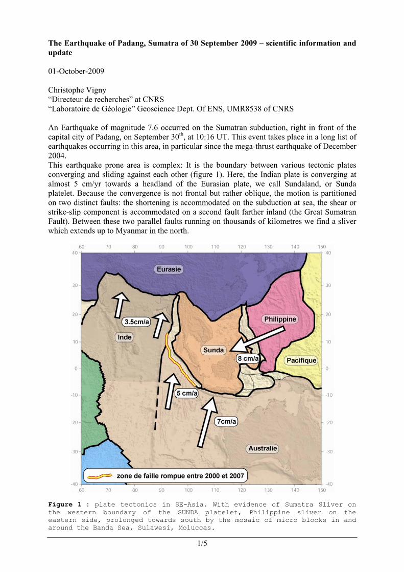
The Earthquake of Padang, Sumatra of 30 September 2009 – scientific information and update 01-October-2009 Christophe Vigny “Directeur de recherches” at CNRS “Laboratoire de Géologie” Geoscience Dept. Of ENS, UMR8538 of CNRS An Earthquake of magnitude 7.6 occurred on the Sumatran subduction, right in front of the capital city of Padang, on September 30th, at 10:16 UT. This event takes place in a long list of earthquakes occurring in this area, in particular since the mega-thrust earthquake of December 2004. This earthquake prone area is complex: It is the boundary between various tectonic plates converging and sliding against each other (figure 1). Here, the Indian plate is converging at almost 5 cm/yr towards a headland of the Eurasian plate, we call Sundaland, or Sunda platelet. Because the convergence is not frontal but rather oblique, the motion is partitioned on two distinct faults: the shortening is accommodated on the subduction at sea, the shear or strike-slip component is accommodated on a second fault farther inland (the Great Sumatran Fault). Between these two parallel faults running on thousands of kilometres we find a sliver which extends up to Myanmar in the north.
Figure 1 : plate tectonics in SE-Asia. With evidence of Sumatra Sliver on the western boundary of the SUNDA platelet, Philippine sliver on the eastern side, prolonged towards south by the mosaic of micro blocks in and around the Banda Sea, Sulawesi, Moluccas.
2/5
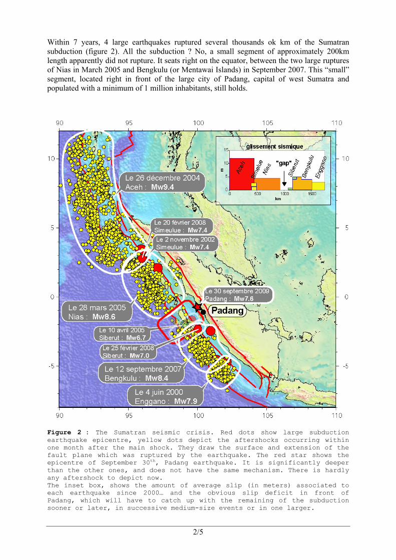
Within 7 years, 4 large earthquakes ruptured several thousands ok km of the Sumatran subduction (figure 2). All the subduction ? No, a small segment of approximately 200km length apparently did not rupture. It seats right on the equator, between the two large ruptures of Nias in March 2005 and Bengkulu (or Mentawai Islands) in September 2007. This “small” segment, located right in front of the large city of Padang, capital of west Sumatra and populated with a minimum of 1 million inhabitants, still holds.
Figure 2 : The Sumatran seismic crisis. Red dots show large subduction earthquake epicentre, yellow dots depict the aftershocks occurring within one month after the main shock. They draw the surface and extension of the fault plane which was ruptured by the earthquake. The red star shows the epicentre of September 30th, Padang earthquake. It is significantly deeper than the other ones, and does not have the same mechanism. There is hardly any aftershock to depict now. The inset box, shows the amount of average slip (in meters) associated to each earthquake since 2000… and the obvious slip deficit in front of Padang, which will have to catch up with the remaining of the subduction sooner or later, in successive medium-size events or in one larger.
3/5
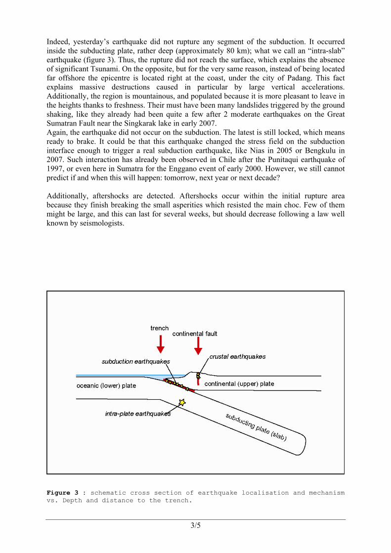
Indeed, yesterday’s earthquake did not rupture any segment of the subduction. It occurred inside the subducting plate, rather deep (approximately 80 km); what we call an “intra-slab” earthquake (figure 3). Thus, the rupture did not reach the surface, which explains the absence of significant Tsunami. On the opposite, but for the very same reason, instead of being located far offshore the epicentre is located right at the coast, under the city of Padang. This fact explains massive destructions caused in particular by large vertical accelerations. Additionally, the region is mountainous, and populated because it is more pleasant to leave in the heights thanks to freshness. Their must have been many landslides triggered by the ground shaking, like they already had been quite a few after 2 moderate earthquakes on the Great Sumatran Fault near the Singkarak lake in early 2007. Again, the earthquake did not occur on the subduction. The latest is still locked, which means ready to brake. It could be that this earthquake changed the stress field on the subduction interface enough to trigger a real subduction earthquake, like Nias in 2005 or Bengkulu in 2007. Such interaction has already been observed in Chile after the Punitaqui earthquake of 1997, or even here in Sumatra for the Enggano event of early 2000. However, we still cannot predict if and when this will happen: tomorrow, next year or next decade? Additionally, aftershocks are detected. Aftershocks occur within the initial rupture area because they finish breaking the small asperities which resisted the main choc. Few of them might be large, and this can last for several weeks, but should decrease following a law well known by seismologists.
Figure 3 : schematic cross section of earthquake localisation and mechanism vs. Depth and distance to the trench.
4/5
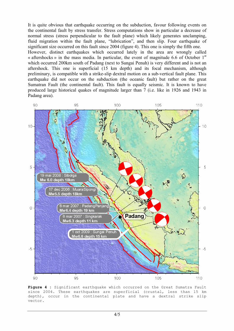
It is quite obvious that earthquake occurring on the subduction, favour following events on the continental fault by stress transfer. Stress computations show in particular a decrease of normal stress (stress perpendicular to the fault plane) which likely generates unclamping, fluid migration within the fault plane, “lubrication”, and then slip. Four earthquake of significant size occurred on this fault since 2004 (figure 4). This one is simply the fifth one. However, distinct earthquakes which occurred lately in the area are wrongly called « aftershocks » in the mass media. In particular, the event of magnitude 6.6 of October 1st which occurred 200km south of Padang (next to Sungai Penuh) is very different and is not an aftershock. This one is superficial (15 km depth) and its focal mechanism, although preliminary, is compatible with a strike-slip dextral motion on a sub-vertical fault plane. This earthquake did not occur on the subduction (the oceanic fault) but rather on the great Sumatran Fault (the continental fault). This fault is equally seismic. It is known to have produced large historical quakes of magnitude larger than 7 (i.e. like in 1926 and 1943 in Padang area).
Figure 4 : Significant earthquake which occurred on the Great Sumatra Fault since 2004. These earthquakes are superficial (crustal, less than 15 km depth), occur in the continental plate and have a dextral strike slip vector.

5/5
Two important questions hold now:
- Will the intra-slab earthquake change the stress field on the interface enough to trigger “at last” the subduction earthquake we expect in the Padang area? We actually expect this earthquake not only since the seismic crisis initiated by the December 2004 giant event, but since 1833, the date of the last mega-thrust earthquake in this area. Indeed, as large as it was, the Bengkulu earthquake of 2007 only released a small part of the deformation accumulated at 4 cm/yr over the last century(ies). The small segment of Padang could rupture alone, producing an earthquake of magnitude around 8, or together with the whole segment of the trench (up to Bengkulu), producing a much larger event.
- Will all this activity on the trench, finally trigger one or several large earthquakes on the Great Sumatran Fault?
Geodetic and seismologic measurements allow quantifying and understanding some aspects of these earthquakes, and thus bring answers. In particular, continuous GPS stations installed in the area allow to determine how much deformation was released by the quake which just happened (all or part of what was available), if deformation is released slowly and silently (good news), or if on the contrary everything is locked. In the later case, one should get ready for a future earthquake and the latest the larger (bad news). Seismological networks, localising micro-seismicity and aftershocks, allow to draw the rupture fault plane. The whole feeds stress transfer computation with precise geometric elements (rupture size, direction, amount of slip, etc….) Our team, in cooperation with local and international agency, makes geodetic (GPS) measurements in Indonesia (in Sumatra, but also Java, Borneo and Sulawesi) and outside Indonesia (in Thailand, Malaysia, Myanmar, etc...) since 1992. We were actually preparing our annual campaign in Indonesia (planned between 15 and 30 October) when this event occurred. We will re-measure the network of geodetic benchmarks to quantify precisely the crustal deformation inflicted by this earthquake, and visit and maintain our cGPS stations, among which some may have suffered (in particular the one installed in hospital MDjamil)