the earthworm based earthquake alarm reporting...
TRANSCRIPT

The Earthworm Based Earthquake Alarm Reporting System in Taiwan
by Da-Yi Chen,* Nai-Chi Hsiao, and Yih-Min Wu
Abstract For more than 10 years, the Central Weather Bureau of Taiwan has op-erated an earthquake early warning (EEW) system and has issued warnings for specificagencies. For the past two years, the Earthworm platform has been used to integratereal-time seismic data streams from different types of seismic stations and to monitorseismicity in Taiwan. Using the Earthworm platform, the Earthworm Based Earth-quake Alarm Reporting (eBEAR) system is currently in development for shorteningreporting times and improving the accuracy of warnings for EEW purposes. TheeBEAR system consists of new Earthworm modules for managing P-wave phase pick-ing, trigger associations, hypocenter locations, magnitude estimations, and alert filter-ing prior to broadcasting. Here, we outline the methodology and performance of theeBEAR system. To calibrate the eBEAR system, an offline test was implemented us-ing 154 earthquakes with magnitudes ranging fromML 4.0 to 6.5. In a comparison ofonline performance using the current EEW system, the eBEAR system reduced report-ing times and improved the accuracy of offshore earthquake locations and magnitudes.Online performance of the eBEAR system indicated that the average reporting timesafforded by the system are approximately 15 and 26 s for inland and offshore earth-quakes, respectively. The eBEAR system now delivers warnings to elementary andjunior high schools in Taiwan.
Introduction
An earthquake early warning (EEW) system is a practi-cal tool for mitigating earthquake hazards. EEW systems arecapable of estimating the occurrence time, location, andmagnitude of an earthquake and of issuing warnings beforestrong ground shaking hits a target area. With timely infor-mation, people and manufacturing facilities are able to takethe necessary precautions to reduce the seismic hazardscaused by large earthquakes. EEW systems have been testedor are currently in use in many countries with high earth-quake hazards (Allen et al., 2009).
Taiwan is located on one of the most active seismiczones in the world, in an area where the Philippine Sea platemoves toward the Eurasia plate at approximately 7 cm=yr(Yu et al., 1997). When two tectonic plates collide, stressesaccumulate then cause earthquakes. The largest damaginginland earthquake to strike Taiwan in the past 20 years wasthe 1999Mw 7.6 Chi-Chi earthquake (Shin and Teng, 2001).Because of rapid urbanization in Taiwan, seismic risks haverecently increased. For example, the 2002 Mw 7.1 easternTaiwan offshore earthquake caused strong ground shakinginside the Taipei basin (Huang et al., 2010). During strongground shaking, a crane operating on top of the constructionarea of the Taipei 101, the tallest building in Taiwan (508 m
tall), crashed and dropped to the ground. The 2010 Mw 6.3Jiasian earthquake brought strong ground motions tosouthern Taiwan, causing an operating Taiwan High SpeedRail train to run off its tracks (Huang et al., 2011; Wu et al.,2011). Given these types of incidents in Taiwan, a reliableand fast EEW system is urgently needed to provide earlywarnings for the next large earthquake.
Over the years, many studies have been conductedregarding the development of an EEW system in Taiwan. In1995, an earthquake rapid reporting system began operatingon the basis of 16-bit strong-motion seismometers and was atype of early-stage EEW system for Taiwan (Wu et al., 1997).Although the system could not issue warnings prior to largeground shaking, it provided rapid reporting within 102 s forthe Chi-Chi earthquake and was the leading technology atthat time (Wu et al., 2000). As EEW system necessity de-manded, the Central Weather Bureau (CWB) was the first totest an EEW prototype system within the Hualien area inTaiwan. To reduce reporting times and provide early warn-ings for distant metropolitan regions, a new idea, based onthe prototype system, was proposed for applying the subnet-work method to earthquake monitoring (Wu et al., 1999).Using the subnetwork concept and ML10, a quick magnitudedetermination method (Wu et al., 1998) that adopted 10 srecords following the first P-wave arrival, the current EEWsystem (the virtual subnetwork [VSN] system) was built and
*Also at Department of Geosciences, National Taiwan University, No. 1,Section 4, Roosevelt Road, Taipei 10617, Taiwan.
568
Bulletin of the Seismological Society of America, Vol. 105, No. 2A, pp. 568–579, April 2015, doi: 10.1785/0120140147
achieved an average 22 s reporting time (the timebetween an earthquake’s origin time and the time the EEWsystem issues a report) (Wu and Teng, 2002). However, dueto the limits of theML10 method, the reporting time could notbe reduced to within 10 s. To further reduce reporting times,the P-wave method, based on the peak amplitude of displace-ment records (Pd) for the vertical component using a 3 s timewindow for magnitude determinations (Wu and Zhao, 2006),was tested and operated (Hsiao et al., 2009, 2011). The CWBhas recently upgraded seismic facilities within the originalseismic network and deployed 30 borehole stations, as wellas one cable-based ocean-bottom seismic station. At thesame time, to enhance the density and coverage of stationdistributions, real-time seismic data streams from variousseismic networks were integrated using the Earthworm plat-form, a program originally developed by the U.S. Geologi-cal Survey (Johnson et al., 1995). Based on the above, anEarthworm-based EEW prototype system was constructedand has been tested since 2007 (Hsiao et al., 2011; Chenet al., 2012).
To enhance data-processing capabilities and reduce re-porting times, we propose the use of the Earthworm BasedEarthquake Alarm Reporting (eBEAR) system within thecurrent EEW system. The algorithms of the eBEAR system,which provide earthquake parameters and filtering alerts,were developed by performing an offline test using 154events with magnitudes ranging from 4.0 to 6.5. To deter-mine whether or not the eBEAR system was capable of ahigher level of performance, we also compared the onlineperformance of the VSN and eBEAR systems. The eBEARsystem is currently operated by the CWB and since January2014 has broadcasted warnings to elementary and juniorhigh schools in Taiwan.
The Seismic Network in Taiwan
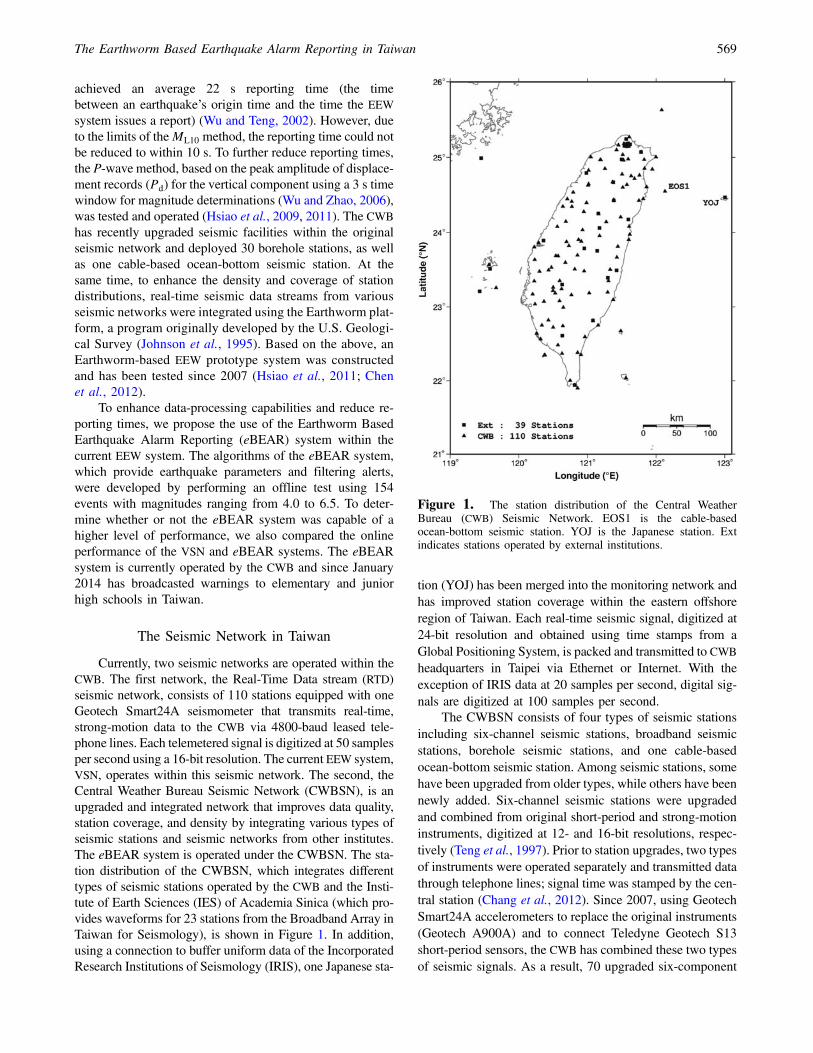
Currently, two seismic networks are operated within theCWB. The first network, the Real-Time Data stream (RTD)seismic network, consists of 110 stations equipped with oneGeotech Smart24A seismometer that transmits real-time,strong-motion data to the CWB via 4800-baud leased tele-phone lines. Each telemetered signal is digitized at 50 samplesper second using a 16-bit resolution. The current EEW system,VSN, operates within this seismic network. The second, theCentral Weather Bureau Seismic Network (CWBSN), is anupgraded and integrated network that improves data quality,station coverage, and density by integrating various types ofseismic stations and seismic networks from other institutes.The eBEAR system is operated under the CWBSN. The sta-tion distribution of the CWBSN, which integrates differenttypes of seismic stations operated by the CWB and the Insti-tute of Earth Sciences (IES) of Academia Sinica (which pro-vides waveforms for 23 stations from the Broadband Array inTaiwan for Seismology), is shown in Figure 1. In addition,using a connection to buffer uniform data of the IncorporatedResearch Institutions of Seismology (IRIS), one Japanese sta-
tion (YOJ) has been merged into the monitoring network andhas improved station coverage within the eastern offshoreregion of Taiwan. Each real-time seismic signal, digitized at24-bit resolution and obtained using time stamps from aGlobal Positioning System, is packed and transmitted to CWBheadquarters in Taipei via Ethernet or Internet. With theexception of IRIS data at 20 samples per second, digital sig-nals are digitized at 100 samples per second.
The CWBSN consists of four types of seismic stationsincluding six-channel seismic stations, broadband seismicstations, borehole seismic stations, and one cable-basedocean-bottom seismic station. Among seismic stations, somehave been upgraded from older types, while others have beennewly added. Six-channel seismic stations were upgradedand combined from original short-period and strong-motioninstruments, digitized at 12- and 16-bit resolutions, respec-tively (Teng et al., 1997). Prior to station upgrades, two typesof instruments were operated separately and transmitted datathrough telephone lines; signal time was stamped by the cen-tral station (Chang et al., 2012). Since 2007, using GeotechSmart24A accelerometers to replace the original instruments(Geotech A900A) and to connect Teledyne Geotech S13short-period sensors, the CWB has combined these two typesof seismic signals. As a result, 70 upgraded six-component
Figure 1. The station distribution of the Central WeatherBureau (CWB) Seismic Network. EOS1 is the cable-basedocean-bottom seismic station. YOJ is the Japanese station. Extindicates stations operated by external institutions.
The Earthworm Based Earthquake Alarm Reporting in Taiwan 569

stations have been constructed, each hosting three-compo-nent short-period velocity sensors and one three-componentstrong-motion sensor.
For EEW purposes, the data loggers located at broad-band seismic stations were replaced using modern equipmentcapable of sending seismic waveforms with a 1 s packetlength. The system consists of 23 stations that use one three-component broadband seismograph. To prevent clipped wave-forms caused by near-field strong shakings, most stations areequipped with an additional three-component strong-motionsensor. Such high-quality waveforms are also used to obtaincentroid moment tensor (CMT) solutions (Shin et al., 2013).
In addition, 30 borehole seismic stations are operational.Each hosts a three-component strong-motion seismographon the surface and a three-component strong-motion seismo-graph, as well as a broadband seismograph within boreholesat a depth of approximately 300 m from the surface. Seismicsignals from borehole seismometers provide waveforms witha high signal-to-noise ratio, useful for improving the accu-racy of phase picking. Since 2008, the number of boreholeseismic stations has increased by approximately five stationseach year. In the near future, the total number of boreholestations will increase to 70.
In November 2011, the first cable-based ocean-bottom seismometer, the Marine Cable Hosted Observatory(MACHO), began operating in Taiwan. The MACHO has oneseismic station located within the northeastern offshore areaof Taiwan, with a cable line length of 45 km, and hosts athree-component strong-motion accelerometer and a three-component broadband seismograph (Hsiao et al., 2013). TheMACHO is very expensive, and only one station is currentlyin operation. However, because the Philippine Sea plate sub-ducts beneath the Eurasia plate of northeastern Taiwan andsince many large earthquakes have occurred in this area inthe past, the MACHO system is critical to the EEW system.The MACHO is capable of detecting seismic waves fasterthan inland stations.
Figure 2 provides the system configuration of theCWBSN for a three-layer structure within the data-processingcenter used for the acquisition, integration, and application ofreal-time seismic signals. In the first layer, real-time seismicdata streams are packaged and transmitted from field stationsor external seismic networks then received by commercial soft-ware or Earthworm via various Internet Protocol (IP)-basednetworks. SMARTGeoHub and Scream software packagesare used to receive real-time seismic waveforms from instru-ments made by Geotech and Güralp, respectively. Seismicwaveforms from external seismic networks provided by IESand IRIS are received using the Earthworm modules IMPOR-T_ACK and SLINK2EW, respectively.
In the second layer, an Earthworm cluster integratesseismic data streams from different seismic instrumentsand provides two types of seismic waveforms. One wave-form type, WAVE_SERVERV, can store and provide seismicwaveforms over a period of time and is used for data displaysand archives. The second waveform type, EXPORT_ACK,
can provide data streams much faster than the previous oneand is used for real-time data processing. For system backup,two computers running WAVE_SERVERV and three com-puters running EXPORT_ACK are operated in parallel.
In the third layer, also called the application layer, sev-eral tasks are performed. These include EEW operation, thegeneration of products obtained from the earthquake catalogand the CMT, the maintenance of the seismic waveform dataarchive, and the display.
Via its modules and shared memory regions, the Earth-worm system is designed for automatic seismic data process-ing (Johnson et al., 1995). Each module has specific taskssuch as data acquisition, processing, and archiving. Adoptingshared memory regions makes it convenient for each moduleto easily receive or broadcast messages such as waveformdata, P-wave arrivals, hypocenter, and magnitude. Earth-worm prepares seismic-related modules and is open source.Therefore, users can use existing modules or create newmodules for specific purposes.
Configuration of the eBEAR System
An Earthworm diagram that describes data flow withinthe eBEAR system is provided in Figure 3a. For systemcalibration, we ran the system in offline mode using theTANKPLAYER module. To receive real-time data for onlineoperations, we applied the IMPORT module. The threecircles provided in Figure 3a represent shared memorieswithin Earthworm. The first shared memory, WAVE_RING,contains waveform data that can be processed using the
Figure 2. A schematic diagram of the data-processing center.SP, short-period stations; SM, strong-motion stations; BB, broad-band stations; BH, borehole stations; and OBS, cable-based ocean-bottom seismic stations. Ext indicates stations operated by externalinstitutions.
570 D.-Y. Chen, N.-C. Hsiao, and Y.-M. Wu

PICK_EEW module to determine P-wave arrivals, as well asthe peak amplitudes for P-wave displacement (Pd), velocity(Pv), and acceleration (Pa) within a 3 s time window. Thesecond shared memory, PICK_RING, not only contains in-formation from the PICK_EEW module, but also providesinformation to the TCPD module for generating earthquakemessages, including source parameters. When an earthquakeoccurs, the TCPD module may update information for theevent and create earthquake messages. Updated earthquakemessages are stored within the third shared memory,HYPO_RING. At the end of the process, the DCSN modulefilters earthquake messages using specific criteria (as dis-cussed later) and generates EEW reports for broadcastingas an XML-formatted file.
Figure 3b provides the hardware configuration of theeBEAR system. For system backup, we designed two paral-lel EEW units, EEW1 and EEW2 that run the same procedureand data for generating earthquake messages. When an earth-quake occurs, both EEW1 and EEW2 send earthquake mes-sages to the system running the DCSN module. Only the firstsystem sending the earthquake message is activated withinthe DCSN module. After receiving an earthquake message,
the DCSN module writes an XML-formatted file onto theEEW server used to broadcast EEW reports to end users; then,to warn the end user, a display program pops up on thecomputer screen.
P-Wave Arrival Picking
The original Earthworm module, PICK_EW, requirestime to check the seismic coda term within the autopickingprocedure. The work is time consuming and not suitablefor EEW systems. Therefore, we created a new module namedPICK_EEW by revising the module and autopicking the pro-cedure to run without checking the seismic coda term. Toavoid false pickings caused by background noise, we alsoadded two parameters, Pa and Pv. Because seismic wave-forms from field stations have different noise levels dependingon vibrations from the natural environment or artificial activ-ities, these two parameters can be used as thresholds for ignor-ing spikes caused by noise. Table 1 provides the parameterswe used in the PICK_EEW module of the eBEAR system.
Figure 3c displays the procedure for P-wave autopick-ing. The PICK_EEW module declares possible picks based
Figure 3. The configuration of the Earthworm Based Earthquake Alarm Reporting (eBEAR) system. (a) A flowchart for data processingwithin the eBEAR system. (b) The hardware configuration of the eBEAR system. (c) A flowchart of the algorithms designed for thePICK_EEW module. The rectangles represent different computers.
The Earthworm Based Earthquake Alarm Reporting in Taiwan 571

on the short-term average (STA) and long-term average (LTA)algorithm. To become a candidate pick of a seismic trace, theratio of STA/LTA should be greater than two times a certainthreshold. Following a pick based on the threshold, and todistinguish ground noise and the seismic signal, we consid-ered three additional conditions: the number of zero cross-ings, the signal-to-noise ratio, and the Pa and Pv. Usingthis procedure, the module was able to qualify the candidatepick as a valid seismic pick. In practice, because each seismicstation has different background noise, we tested differentsets of picking parameters by performing an offline test.
Hypocenter and Magnitude Determinations
After the TCPD modules jointly trigger using a space–time window based on expected travel times, the event hypo-center is estimated using two steps. For determining theevent epicenter, the module first adopts Geiger’s method,an inversion process using a half-space velocity model inwhich velocity linearly increases with depth. For estimatingevent depth, the module then uses a grid search method withdepths ranging from 10 to 100 km in steps of 10 km. Theo-retical travel times to each station are calculated and com-pared to those observed at each depth. Finally, the depthwith minimum residuals and the epicenter determined byGeiger’s method are considered as the event hypocenter.
The procedure is performed within the TCPD modulevia an updating process. At the beginning of the process,after at least six picks of seismic waveforms, the TCPD mod-ule begins to locate an event. When the root mean square(rms) of travel-time residuals resulting from the inversionprocess is larger than 0.8, the pick with the largest travel-timeresiduals is removed and the inversion process is again per-formed. When additional picks of seismic waveforms partici-pate, the procedure of hypocenter determination is repeatedand the estimated hypocenter is updated.
Earthquake magnitudes are predicted using the initialportion of P-wave peak displacement Pd within the 3 s timewindow. Following a double-integrated, strong-motion, andintegrated broadband, the PICK_EEW module applies a0.075 Hz high-pass filter to displacement records. The Pd
value is then used to estimate magnitude (MPd) based on theempirical formula of Hsiao et al. (2011). The empirical for-mula for borehole stations has not yet been established. Inaddition, since the frequency response of the short-periodsensor is approximately 1 Hz, short-period signals may un-derestimate the Pd value for large earthquakes. Only broad-band and strong-motion sensors on the surface are used forPd determinations within the EEW system.
Earthquake magnitude is estimated by obtaining anaverage for each MPd value from each seismic station. How-ever, the false picking of P-wave arrivals, the directivity ef-fect, and site effects may lead to unreasonable MPd values.For obtaining robust estimations of magnitude and to reduceerrors, three steps are applied. First, only MPd values withinone standard deviation of the dataset are used. Next, eachrecord is weighted according to P-wave travel-time residuals.The weighting factor is expressed as
Wi ��
1
1� jRij
�2
; �1�
in whichWi is the weighting factor of eachMPd value and Ri
(in seconds) is the P-wave travel-time residual for each cor-responding MPd value. Finally, a weighted average forobtaining earthquake magnitude is expressed as
M �X�
WiPWi
× Xi
�; �2�
in which Xi is the MPd value for each station.
Table 1The Parameters for P-Wave Phase Picking eBEARS Picker (PICK_EEW)
Parameters Short Description Default Value
MinSmallZC Defines the minimum number of zero crossings for a valid pick within the first second after P-wave arrival 3 for broadband or 5 foracceleration
MaxMint The maximum interval (in samples) between zero crossings 100RawDataFilt Sets the filter parameter RawDataFilt applied to the raw trace data 0.939CharFuncFilt Sets the filter parameter CharFuncFilt applied during calculations of the characteristic function of
waveform data3
StaFilt Sets the filter parameter (time constant) StaFilt used in the calculation of the short-term average (STA) ofthe characteristic function of the trace
0.6
LtaFilt Sets the filter parameter (time constant) LtaFilt used in the calculation of the long-term average (LTA) ofthe characteristic function of the trace
0.15
EventThresh Sets the STA/LTA event threshold 5RmavFilt The filter parameter (time constant) used to calculate the running mean of the absolute value of the
waveform data0.9961
DeadSta Sets the dead station threshold (counts) 1,000,000MinPa Defines the minimum value of peak amplitude for acceleration for a valid pick 0.01MinPv Defines the minimum value of peak amplitude for velocity for a valid pick 0.0001
572 D.-Y. Chen, N.-C. Hsiao, and Y.-M. Wu

EEW Reports
When an earthquake occurs, the number of seismicpicks are increased as seismic waves propagate away fromthe epicenter. As a result, the TCPD module determines theearthquake message and continuously updates that message.We propose that the numbers of updating earthquake mes-sages will increase quickly and will be significant for largeand local earthquakes. In contrast, for small earthquakes orfor noise, the number of updating earthquake messages willincrease slowly and will be small. Therefore, if the EEW sys-tem determines a large number of updating earthquake mes-sages for an ongoing earthquake, we consider the EEWinformation as a reliable warning.
To prevent false alarms, the DCSN module always skipsthe first and second earthquake message generated from theTCPD module. The third earthquake message is the firstEEW report to users. The EEW report is written in an XML-formatted file for broadcasting. The EEW report is updatedeither when differences in the magnitude or the epicenter arelarger than 0.5 or 20 km, respectively, as compared to the lastEEW report.
Figure 4 provides a user display that pops up automati-cally when an XML-formatted message is received. The dis-play estimates the seismic intensity, the wavefronts of P- andSwaves, and the remaining warning time (defined as the time
between the reporting time and the arrival of the S wave tothe target area). If the EEW report is updated, the user displaydirectly changes the location of the epicenter and againre-estimates EEW-related parameters.
The Offline Test and Online PerformanceComparison
To calibrate the eBEAR system, an offline test wasimplemented in this study. From 2012 to 2013, we collectedrecorded seismic waveforms with magnitudes greater than4.0, depths less than 40 km, and epicenters within 40 kmof the coastline of Taiwan based on the upgraded CWBSN.A total of 154 seismic events, including four events withmagnitudes between 6.0 and 6.5, were used in the test. Theresults, including earthquake locations and magnitudes, werecompared to the CWB earthquake catalog. The reporting timeof the offline test (defined as the time the EEW report isissued following the event origin time) does not include atelemetry delay of within 2 s. Figure 5 provides the offlineperformance of the eBEAR system in comparison with theresults from the CWB catalog. The average errors for epicen-ter and focal depth locations are 4.2 and 5.3 km, respectively.The standard deviation of the local magnitude is 0.3 units.The average reporting time is 14.7 s. Some events locatedin southwestern Taiwan with relatively higher station density
Figure 4. Graphical output of the eBEAR system during a simulation of the ML 6.5 earthquake in central Taiwan. (top left) The originevent time and the name of the target city. (center) The square represents the target area, the black line represents the wavefront of the Pwave,and the white line represents the wavefront of the S wave. (center right) The countdown timer for the S-wave arrival. (top right) The predictedintensity in the target area. The color version of this figure is available only in the electronic edition.
The Earthworm Based Earthquake Alarm Reporting in Taiwan 573

and coverage may be reported within 10 s. The offline resultsare acceptable for EEW purposes and suggest three points.First, the two-step method for determination of the epicenterand focal depth is suitable for a complicated tectonic envi-ronment such as Taiwan. Second, using a Pd value within a3 s time window following P-wave arrival is useful for mea-suring the size of moderate-sized earthquakes with magni-tudes ranging from 4.0 to 6.5. Third, when an earthquakeoccurs in an area with a relatively higher station density andcoverage, the number of updating earthquake messagesquickly increases within the eBEAR system. For this typeof event, the system is able to obtain a third earthquake mes-sage (an EEW report) within a short period of time. For fur-ther discussion of the reporting time, Figure 6 provides therelationship between the reporting time and the station cover-age gap. For most inland events with a station coverage gapgenerally less than 150°, reporting can occur within 15 s. Onthe other hand, for offshore events the reporting times maytake more than 20 s when the station coverage gap is greaterthan 200°. The results indicate that currently the station cov-
Figure 5. A comparison between the offline test and the CWB published catalog, as follows: (a) the epicenters, (b) the magnitudes, (c) thefocal depths, and (d) the reporting time of the offline test. Open circles represent earthquake locations obtained from the published CWBcatalog, and solid circles represent earthquake locations from the eBEAR system.
Figure 6. The relationship between reporting time and stationcoverage gap.
574 D.-Y. Chen, N.-C. Hsiao, and Y.-M. Wu

erage gap is a key factor for controlling the reporting time ofthe eBEAR system.
For an online system comparison between the VSN andeBEAR systems, we collected online operating performancedata from January to March of 2014. Figure 7a,b indicatesthat the eBEAR system had no missed events and that deter-minations of location were better than for the VSN system.For inland earthquakes, both systems had location errors lessthan 10 km. On the other hand, for offshore earthquakes, theVSN system missed two events and displayed larger locationerrors of approximately 50–100 km. On average, the epicen-ter errors of the eBEAR and VSN systems are 10.0 and16.2 km, respectively. When considering depth determina-tions, the VSN displayed better results than the eBEAR sys-tem because the VSN system used both P- and S-wavearrivals, whereas the eBEAR system only used P-wave arriv-als (Fig. 7a,b). For magnitude determinations, the eBEARsystem yielded a smaller standard deviation (0.2) compared tothe VSN system, with a standard deviation of 0.5 (Fig. 8a,b).The solid circles represent the events detected by both sys-tems; the open circles represent the events only detected bythe eBEAR system. If we only compare the solid circles, italso shows the eBEAR system has better magnitude estima-tions than the VSN system. In the comparison of reporting
times, Figure 9a,b indicates that almost every earthquakeprocessed by the eBEAR system displayed an earlier report-ing time. On average, the eBEAR system shortens reportingtimes by 3.2 and 5.5 s, compared to the VSN system forinland and offshore earthquakes, respectively. Because theeBEAR system contains 149 seismic stations distributed ina smaller station coverage gap and because station locationsare denser than the VSN system based on 110 stations, theeBEAR system can obtain an EEW report more efficientlythan the VSN system. Moreover, for an earthquake thatoccurred in the southern Taiwan offshore area, the stationdistributions of the eBEAR system and the VSN system aresimilar, but the difference of the reporting time is about 9 s(Fig. 9). This indicates the eBEAR system can be operatedmore efficiently than the VSN system without considering theinfluence of the station distribution. Figure 10 provideswarning times to target areas in metropolitan Taipei. Warningtime is defined as the time between the reporting time and thearrival of the S wave. The eBEAR system provides a longerwarning time than the VSN system. For the eastern offshorearea of Taiwan, the eBEAR system can provide a warningtime that is 5 s longer, on average, than the VSN system.The major reason is that by adding the MACHO systemand the YOJ station into the seismic network, the eBEAR
Figure 7. Location estimations as compared to online performance between the eBEAR and virtual subnetwork (VSN) systems: (a) theepicenter distribution of the CWB catalog and events of the earthquake early warning (EEW) alarms and missed alarms from the eBEARsystem, and (b) the epicenter distribution of the CWB catalog and events of the EEW alarms and missed alarms from the VSN system. Opencircles represent earthquake locations from the published CWB catalog, solid circles represent earthquake locations from the EEW system, andopen triangles represent missing reports from the EEW system.
The Earthworm Based Earthquake Alarm Reporting in Taiwan 575

system has a smaller station coverage gap. In addition, forevents with the approximate locations of the 1999 Mw 7.6Chi-Chi earthquake and the 2002Mw 7.1 eastern Taiwan off-shore earthquake, the Taipei metropolitan area would havehad a warning time of 26 and 15 s, respectively.
EEW Disseminations of the eBEAR System
The eBEAR system has issued EEW warnings to about3600 junior and senior high schools in Taiwan since January2014. Those schools receive warnings from the CWB and
Figure 8. Magnitude estimations as compared to online performance between the eBEAR and VSN systems: (a) results from the eBEARsystem and (b) results from the VSN system. The solid circles represent the events detected by the eBEAR and VSN systems. The open circlesrepresent the events only detected by the eBEAR system. The solid line represents the 1∶1 line. Dashed lines represent one standard deviation.
Figure 9. The reporting time comparison for online performance between the eBEAR and VSN systems: (a) results from the eBEARsystem using 149 stations within the CWBSN, and (b) results from the VSN system using 110 real-time data stream (RTD) stations.
576 D.-Y. Chen, N.-C. Hsiao, and Y.-M. Wu

transfer messages to their broadcast system using a user-display software, shown in Figure 4. From January 2014 toSeptember 2014, there are 28 earthquakes with magnitudegreater than 4.5 and depth less than 40 km reported by theCWB. The eBEAR system has reported 20 events and missed8 events. Figure 11 shows the epicenters distribution of thereported and missed events, as well as the reporting times ofthe eBEAR system. All of the missed events are located onthe offshore area. For the reported events, the average loca-tion error is 4:7� 2:9 km and the average magnitude error is0:2� 0:1. The 21 May 2014 Hualien earthquake with localmagnitude 6.0 is the largest event during this period. TheeBEAR system issued the alert 15.4 s after the earthquakeoccurrence. It can provide about 25 s leading time for theTaipei area.
Since January 2014, there have been two false alertsissued by the system. Neither false alert was caused by falsetriggers. Instead, improper operation caused the false alertsto be generated and sent to the schools. The first false alarmwas caused by performing an offline test; because the offlineand the online systems run on the same computer, the resultof the offline test was sent to the online reporting system andcaused a false alert. To avoid this kind of false alarm, weseparated the offline and online systems.
The second false alarm was caused by the Earthwormcommunication modules that provide a rapid message
exchange facility between two Earthworm processing sys-tems. When the earthquake occurred, the EEW1 determinedthe source parameters and sent them to the DCSN using thecommunication modules, as shown in Figure 3. However, theEEW message could not be sent (and instead was stored inthe memory) because the connection between the communi-cation modules was broken. When the system operator foundthe connection problem and restarted them several hourslater, they were reconnected again. As a result, the sourceparameters were received by the DCSN. The alert was thensent to the schools, but it was delayed for several hours afterthe earthquake occurred. To solve the connection problem,we started to monitor heartbeat debug messages, which isa hand-shaking procedure between the communicationmodules. The system operator can figure out the connectionproblems and fix them before the system is triggered byearthquakes.
Discussion and Conclusions
In general, station coverage gap is a key factor for con-trolling performance within the eBEAR system. If an earth-quake is detected by a group of seismic stations with asmaller station coverage gap, the EEW system is capableof high-quality hypocenter estimations and the rms of thetravel-time residuals is smaller (Wu, Chang, et al., 2013).
Figure 10. Warning time comparisons for online performance between the eBEAR and VSN systems: (a) results from the eBEAR systemusing 149 stations, and (b) results from the VSN system using 110 RTD stations. The solid square represents the target area for obtainingwarnings, and open circles represent epicenters. The number over the open circle is the warning time, defined as the time between thereporting time and the arrival of the S wave. If the warning time value is negative, the target area has no warning time.
The Earthworm Based Earthquake Alarm Reporting in Taiwan 577

For reliable magnitude estimations, good station coveragealso reduces directivity effects by averaging the magnitudesof different stations that surround the epicenter. Moreover, be-cause stable results of the EEW system can be obtained earlier,the EEW system is capable of reducing response times. TheCWBSN is broader and the distribution denser than the RTD.Therefore, eBEAR system performance for location, magni-tude, and reporting time are better than for the VSN.
Compared to the CWB catalog, the magnitude of thestandard deviation for estimations of moderate-sized earth-quake magnitudes in the eBEAR system is 0.3, indicatingthat the magnitude estimations are good for EEW purposes.However, it is difficult to predict earthquake magnitudes oflarge events within a few seconds of early P waves (Hoshibaand Iwakiri, 2011; Colombelli et al., 2012). Once a largeearthquake occurs, the rupture process is not approximatelya point-source problem. The majority of released energy dur-ing the rupture process may not occur at the beginning of therupture. Therefore, only acquiring information a few secondsafter P-wave arrival is not enough for estimating the entire
energy from an event. Magnitude growth must be trackedand updated over time.
In Taiwan, the VSN system has operated and issuedwarnings to specific agencies for more than 10 years. Thetechnology for data processing and information transmissionis not efficient. The current system consists of a series ofcomputers, programmed for individual tasks that are con-nected to one another (Wu and Teng, 2002). Using a Win-dows-based personal computer (Microsoft Corporation),tasks include data acquisition, phase picking, and determina-tions of earthquake location and magnitude. Each computerarchives its result in text files and moves these files to anothercomputer for delivering messages. The procedure takes timeto produce files and increases the reporting time after anearthquake occurs. In contrast, Earthworm exchanges mes-sages more efficiently. Earthworm communicates betweenmodules with shared memory regions on local computers andtransmission control protocol/IP protocols on remote com-puters. In this work, the eBEAR system was improved basedon a comparison of the VSN system. Because of the use of theP-wave method and an increase in station density and cover-age using the Earthworm configuration, the eBEAR system iscapable of providing fast and robust EEW information. Onaverage, the reporting time for inland earthquakes occurswithin approximately 16 s and for offshore earthquakes oc-curs within approximately 27 s, indicating that the radius ofthe blind zone area is approximately 60 km for inland eventsand 100 km for offshore events. However, some eastern off-shore events have an approximate 27 s reporting time andcould still provide enough of a warning time for inland re-gions if a large earthquake occurs. In the future, it is possibleto further reduce the reporting time by deploying more seismicstations in the mountainous areas of Taiwan so that the geom-etry of the seismic network is more evenly distributed.
The eBEAR system is a portable package within Earth-worm. Any seismic network containing Earthworm is easy tooperate with the eBEAR system. Therefore, the low costEEW network of Taiwan, named P-alert, running in Earth-worm with more than 500 stations (Wu, Chen, et al., 2013;Hsieh et al., 2014; Wu, 2014), is the next candidate to testwith the eBEAR system. If the CWBSN and P-alert seismicnetworks are merged together, the density and coverage ofseismic stations will be greatly enhanced. With an enhancednetwork, reporting times can be reduced further with theeBEAR system. In addition, providing more robust measure-ments of magnitudes can be estimated easily using initialP-wave amplitudes and their spatial distributions (Lin et al.,2011).
Data and Resources
The records used in this study were collected from theCentral Weather Bureau Seismic Network of Taiwan. Accessto waveform records can be obtained from the owners uponrequest (http://www.cwb.gov.tw/eng/index.htm; last ac-cessed December 2014).
Figure 11. EEW disseminations of the eBEAR system. Thereare 28 events with magnitude greater than 4.5 and depth less than40 km from January 2014 to September 2014. The eBEAR systemreported 20 events, indicated as open circles. The size of circlescorresponds to the reporting time. Eight events were not reportedby the eBEAR system (open triangles). During this period the larg-est event occurred in the Hualien area, with local magnitude 6.0 andreported at 15.4 s after the earthquake occurrence.
578 D.-Y. Chen, N.-C. Hsiao, and Y.-M. Wu

Acknowledgments
We would like to thank three anonymous reviewers for providingconstructive comments. Earthworm (Johnson et al., 1995) and GenericMapping Tools (GMT; Wessel and Smith, 1998) software programs wereused in this study and are gratefully acknowledged. Our work was supportedby the Ministry of Science and Technology, Taiwan.
References
Allen, R. M., P. Gasparini, O. Kamigaichi, andM. Böse (2009). The status ofearthquake early warning around the world: An introductory overview,Seismol. Res. Lett. 80, 682–693, doi: 10.1785/gssrl.80.5.682.
Chang, C. H., Y.-M. Wu, D.-Y. Chen, T.-C. Shin, T.-L. Chin, andW.-Y. Chang (2012). An examination of telemetry delay in the CentralWeather Bureau Seismic Network, Terr. Atmos. Ocean. Sci. 23, 261–268.
Chen, D.-Y., T. L. Lin, Y.-M. Wu, and N.-C. Hsiao (2012). Testing a P-waveearthquake early warning system by simulating the 1999 Chi-Chi,Taiwan, Mw 7.6 earthquake, Seismol. Res. Lett. 83, 103–108, doi:10.1785/gssrl.83.1.103.
Colombelli, S., A. Zollo, G. Festa, and H. Kanamori (2012). Early magni-tude and potential damage zone estimates for the great Mw 9 Tohoku-Oki earthquake, Geophys. Res. Lett. 39, L22306, doi: 10.1029/2012GL053923.
Hoshiba, M., and K. Iwakiri (2011). Initial 30 seconds of the 2011 Off thePacific Coast of Tohoku earthquake (Mw 9.0)—Amplitude and tau(c)for magnitude estimation for earthquake early warning, Earth PlanetsSpace 63, 553–557.
Hsiao, N.-C., T.-W. Lin, S.-K. Hsu, K.-W. Kuo, T.-C. Shin, and P.-L. Leu(2013). Improvement of earthquake locations with the Marine CableHosted Observatory (MACHO) offshore NE Taiwan, Mar. Geophys.Res. doi: 10.1007/s11001-013-9207-3.
Hsiao, N.-C., Y.-M. Wu, T.-C. Shin, L. Zhao, and T.-L. Teng (2009).Development of earthquake early warning system in Taiwan, Geophys.Res. Lett. 36, L00B02, doi: 10.1029/2008gl036596.
Hsiao, N.-C., Y.-M. Wu, L. Zhao, D.-Y. Chen, W.-T. Huang, K.-H. Kuo,T.-C. Shin, and P.-L. Leu (2011). A new prototype system forearthquake early warning in Taiwan, Soil Dynam. Earthq. Eng. 31,201–208, doi: 10.1016/j.soildyn.2010.01.008.
Hsieh, C. Y., Y. M. Wu, T. L. Chin, K. H. Kuo, D. Y. Chen, K. S. Wang, Y. T.Chan, W. Y. Chang, W. S. Li, and S. H. Ker (2014). Low cost seismicnetwork practical applications for producing quick shaking maps inTaiwan, Terr. Atmos. Ocean. Sci. 25, 617–624, doi: 10.3319/TAO.2014.03.27.01(T).
Huang, H. H., Y. M. Wu, T. L. Lin, W. A. Chao, J. B. H. Shyu, C. H. Chan,and C. H. Chang (2011). The preliminary study of the 4 March 2010Mw 6.3 Jiasian, Taiwan, earthquake sequence, Terr. Atmos. Ocean. Sci.22, 283–290, doi: 10.3319/TAO.2010.12.13.01(T).
Huang, Y. L., B. S. Huang, K. L. Wen, Y. C. Lai, and Y. R. Chen (2010).Investigation for strong ground shaking across the Taipei basin duringtheMw 7.0 eastern Taiwan offshore earthquake of 31 March 2002, Terr.Atmos. Ocean. Sci. 21, 485–493, doi: 10.3319/TAO.2009.12.11.01(TH).
Johnson, C. E., A. Bittenbinder, B. Bogaert, L. Dietz, and W. Kohler (1995).Earthworm: A flexible approach to seismic network processing, IRISNewsletter 14, 4.
Lin, T. L., Y. M. Wu, and D. Y. Chen (2011). Magnitude estimation usinginitial P-wave amplitude and its spatial distribution in earthquake earlywarning in Taiwan, Geophys. Res. Lett. 38, L09303, doi: 10.1029/2011GL047461.
Shin, T.-C., and T.-l. Teng (2001). An overview of the 1999 Chi-Chi,Taiwan, earthquake, Bull. Seismol. Soc. Am. 91, 895–913, doi:10.1785/0120000738.
Shin, T.-C., C.-H. Chang, H.-C. Pu, H.-W. Lin, and P.-L. Leu (2013). Thegeophysical database management system in Taiwan, Terr. Atmos.Ocean. Sci. 24, 11–18.
Teng, T. L., L. Wu, T. C. Shin, Y. B. Tsai, and W. H. K. Lee (1997). Oneminute after: Strong-motion map, effective epicenter, and effectivemagnitude, Bull. Seismol. Soc. Am. 87, 1209–1219.
Wessel, P., and W. H. F. Smith (1998). New, improved version of GenericMapping Tools released, EOS Trans. AGU. 79, 579.
Wu, Y. M. (2014). Progress on development of an earthquake early warningsystem using low cost sensors, Pure Appl. Geophys. doi: 10.1007/s00024-014-0933-5.
Wu, Y.-M., and T.-L. Teng (2002). A virtual subnetwork approach to earth-quake early warning, Bull. Seismol. Soc. Am. 92, 2008–2018.
Wu, Y.-M., and L. Zhao (2006). Magnitude estimation using the first threeseconds P-wave amplitude in earthquake early warning,Geophys. Res.Lett. 33, doi: 10.1029/2006gl026871.
Wu, Y. M., C. H. Chang, H. Kuo-Chen, H. H. Hunag, and C. Y. Wang(2013). On the use of explosion records for examining earthquake lo-cation uncertainty in Taiwan, Terr. Atmos. Ocean. Sci. 24, 685–694,doi: 10.3319/TAO.2013.01.31.01(T).
Wu, Y. M., D. Y. Chen, T. L. Lin, C. Y. Hsieh, T. L. Chin, W. Y. Chang, W. S.Li, and S. H. Ker (2013). A high-density seismic network for earth-quake early warning in Taiwan based on low-cost sensors, Seismol.Res. Lett. 84, 1048–1054, doi: 10.1785/0220130085.
Wu, Y.-M., J.-K. Chung, T.-C. Shin, N.-C. Hsiao, Y.-B. Tsai, W. H. K. Lee,and T.-l. Teng (1999). Development of an integrated earthquake earlywarning system in Taiwan—Case for Hualien area earthquakes, Terr.Atmos. Ocean. Sci. 10, 719–736.
Wu, Y. M., W. H. K. Lee, C. C. Chen, T. C. Shin, T. L. Teng, and Y. B.Tsai (2000). Performance of the Taiwan Rapid Earthquake InformationRelease System (RTD) during the 1999 Chi-Chi (Taiwan) earthquake,Seismol. Res. Lett. 71, 338–343.
Wu, Y.-M., T.-L. Lin, W.-A. Chao, H.-H. Huang, N.-C. Hsiao, and C.-H.Chang (2011). Faster short-distance earthquake early warning usingcontinued monitoring of filtered vertical displacement: A case studyfor the 2010 Jiasian, Taiwan, earthquake, Bull. Seismol. Soc. Am.101, 701–709, doi: 10.1785/0120100153.
Wu, Y.-M., T.-C. Shin, C.-C. Chen, W. H. K. Lee, and T. L. Teng (1997).Taiwan rapid earthquake information release system, Seismol. Res.Lett. 68, 931–943.
Wu, Y. M., T. C. Shin, and Y. B. Tsai (1998). Quick and reliable determi-nation of magnitude for seismic early warning, Bull. Seismol. Soc. Am.88, 1254–1259.
Yu, S. B., H. Y. Chen, L. C. Kuo, S. E. Lallemand, and H. H. Tsien (1997).Velocity field of GPS stations in the Taiwan area, Tectonophysics 274,41–59.
Central Weather BureauNo. 64, Kung-Yuan RoadTaipei 10048, Taiwan
(D.-Y.C., N.-C.H.)
Department of GeosciencesNational Taiwan UniversityNo. 1, Section 4, Roosevelt RoadTaipei 10617, [email protected]@gmail.com
(Y.-M.W.)
Manuscript received 28 May 2014;Published Online 3 February 2015
The Earthworm Based Earthquake Alarm Reporting in Taiwan 579