the economic benefits of cleaning up the … · the economic benefits of cleaning up the ... 1 the...
TRANSCRIPT

CLEANING UP THE CHESAPEAKE A VALUAT ION OF THE NATURAL BENEFITS GAINED BY IMPLEMENTING THE CHESAPEAKE CLEAN WATER BLUEPRINT
OCTOBER 2014
THE ECONOMIC BENEFITS OF

The Chesapeake Bay Foundation gratefully acknowledges the generosity of
Albert H. Williams for underwriting this report.

CBF.ORG/ECONOMICBENEFITS OCTOBER 2014 CHESAPEAKE BAY FOUNDATION 1
Executive SummaryThe Economic Benefits of Cleaning Up the ChesapeakeA Valuation of the Natural Benefits Gained by Implementing the Chesapeake Clean Water Blueprint
The Chesapeake Bay is a national treasure. Its forests, wetlands, and waters provide many natural benefits to the 17 million people and associated plants and animals that call this 64,000- square-mile region home. But those benefits have been greatly reduced by agricultural, urban and suburban, sewage treatment, and air pollution.
In 2010, the six Bay states, the District of Columbia, and the federal government began a renewed effort to restore the health of the Bay and its vast network of rivers and streams. That effort—the Chesapeake Clean Water Blueprint1—is designed to substantially reduce the amount of nitrogen, phosphorus, and sediment pollution that enters local waters and the Bay. Its goal: to restore the Bay’s ecological health. In doing so, implementing the Blueprint will reduce risks to our health, provide a legacy of clean water for our children and grandchildren, and increase economic benefits to the region.
Fully implementing the Blueprint is a big job. It requires the commitment, time, and resources of all sectors of our society and every individual in the watershed.
So, what will be the return? According to the peer-reviewed economic report, The Economic Benefits of Cleaning Up the Chesapeake, it will be tremendous. The report’s findings include the following:
1. In 2009 (before the Blueprint), the lands and waters of the Chesapeake Bay region provided economic benefits totaling $107.2 billion annually. This serves as the baseline for our study. These benefits include air and water filtration, agricultural and seafood production, property valuation, and flood and hurricane protection.
2. The value of these same benefits will increase by $22.5 billion to $129.7 billion annually if the Blueprint is fully implemented. Once realized, those benefits would be enjoyed year after year.
3. If the Blueprint is not fully implemented, pollution loads will increase, and the value of the natural benefits will decline by $5.6 billion annually to $101.5 billion. The value of the Bay region’s natural benefits will decline further after 2025 as additional pollution continues to degrade our natural resources.
1 The Blueprint includes the science-based pollution limits established by the Chesapeake Bay Total Maximum Daily Load and the state-specific implementation plans designed to achieve those limits. EPA and the Bay jurisdictions agreed to implement practices to achieve 60 percent of the necessary pollution reductions by 2017, and 100 percent of those practices in place by 2025.
ATLANTICOCEAN
MARYLAND
CANADA
OHIO
NORTH CAROLINA
CT
MA
NH
VT
PENNSYLVANIA
NEW YORK
WESTVIRGINIA
NEWJERSEY
VIRGINIA
DELAWAREWASHINGTON, DC
0 50 Miles
LUCI
DID
TY I
NFO
RMAT
ION
DES
IGN

2 CHESAPEAKE BAY FOUNDATION OCTOBER 2014 CBF.ORG/ECONOMICBENEFITS
CLIMATE STABILITYInfluence of land cover and biologically mediated processes on maintaining a favorable climate, promoting human health, crop productivity, recreation, and other services.
Chesapeake land uses that provide this benefit:
Forest Urban Open Wetland
FOOD PRODUCTIONThe harvest of agricultural produce, including crops, livestock, and livestock by-products; the food value of hunting, fishing, etc.; and the value of wild-caught and aquaculture-produced fin fish and shellfish.
Chesapeake land uses that provide this benefit:
Agriculture Open Water Wetland
WATER FLOW REGULATIONModulation by land cover of the timing of runoff and river discharge, resulting in less severe drought, flooding, and other consequences of too much or too little water available at the wrong time or place.
Chesapeake land uses that provide this benefit:
Forest Urban Open Urban Other Wetland
WATER SUPPLYFiltering, retention, storage, and delivery of fresh water—both quality and quantity— for drinking, irrigation, industrial processes, and other uses.
Chesapeake land uses that provide this benefit:
Forest Open Water Wetland
What Are Natural Benefits?Our lands, waters, and associated plants and animals provide natural benefits that economists call ecosystem services. People depend on these services to sustain and enhance human life. In addition to the production of goods such as food and timber, these benefits from nature include life-supporting processes such as water and air purification and flood protection, and life-enhancing assets such as beautiful places to recreate and live. Despite their vital importance, these natural benefits are often taken for granted, their value not quantified. Over the past decade, however, the acceptance of forests, wetlands, and other ecosystems as vital economic assets has led to an increase in studies calculating these natural benefits in regions including the Everglades, the Mississippi Delta, the Puget Sound—and now the Chesapeake.
AIR POLLUTION TREATMENTPurification of air through the absorption and filtering of airborne pollutants by trees and other vegetation, yielding cleaner, more breathable air (reduction of NOx, SOx, CO2), reduced illness, and an improved quality of life. (Note: Economists more commonly call this “Gas Regulation.”)
Chesapeake land uses that provide this benefit:
Forest Urban Open Wetland
WASTE TREATMENTRemoval or breakdown of nutrient pollution and other chemicals by vegetation, microbes, and other organisms, resulting in fewer, less toxic, and/or lower volumes of pollutants in the system.
Chesapeake land uses that provide this benefit:
Forest Open Water Wetland
RECREATIONThe availability of a variety of safe and pleasant landscapes—such as clean water and healthy shorelines—that encourage ecotourism, outdoor sports, fishing, wildlife watching, etc.
Chesapeake land uses that provide this benefit:
Agriculture Forest Open WaterUrban Open Wetland Other
AESTHETIC VALUEThe role that beautiful, healthy natural areas play in attracting people to live, work, and recreate in a region; often reflected in property values.
Chesapeake land uses that provide this benefit:
Agriculture Forest Open WaterUrban Open Wetland Other

CBF.ORG/ECONOMICBENEFITS OCTOBER 2014 CHESAPEAKE BAY FOUNDATION 3
The MethodsTo analyze the benefits that the Chesapeake Bay’s watershed (a six-state drainage area) provides, the authors first established a 2009 baseline. They considered the environmental condition of seven types of land use: agriculture, forest, wetland, open water, urban open space, urban other (e.g., paved areas), and other (mostly barren land). These land uses were derived from data from the Chesapeake Bay Program and the National Land Cover Database.
Next, they calculated how the amount and pro duc tivity of these land uses would change if the Chesapeake Clean Water Blueprint were fully implemented or, alternatively, not implemented, Business as Usual.
The authors then drew from existing economic studies to calculate the dollar value of eight ben efits that we enjoy and that are supplied by these land uses. The eight are: climate stability, food production, water regulation, water supply, air pollution treatment, waste treatment, recreation, and aesthetic value.
Finally, for each land use they calculated the total value of the natural benefits under the three scenar-ios (Baseline, Blueprint, Business as Usual) by multiplying the acres and condition of each land-use type by the dollar value of the applicable eight natural benefits.
(The methodology is fully explained on pages 8 through 12 of the report, The Economic Benefits of Cleaning Up the Chesapeake.)
The ResultsWhen we implement the Blueprint, some highly polluting land uses will be converted to uses that produce more natural benefits. For example, agricul-tural fields that use proven conservation practices and urban spaces that incorporate common sense development solutions (rain gardens and paving that soaks in rain) will pollute less and provide increased benefits. In addition, the conversion of land from forests and wetlands to uses that produce fewer natural benefits (like parking lots and subdivisions) will occur at a slower pace. As we reduce the amount of nitrogen, phosphorus, and sediment pollution, that flows to our waters, the ecosystems on all the various land uses will become healthier, more capable of providing benefits.
If we fail to implement the Blueprint, we can expect to lose more forests and wetlands to development. Fewer pollution controls will be implemented on urban and suburban streets and agricultural fields. Increases in pollution will degrade ecosystems and as a result they will produce fewer natural benefits.
The report indicates that the benefits provided by the 64,000-square-mile Chesapeake Bay water-shed, including its tidal areas, can be valued at more than $107 billion annually. Furthermore, when the Blueprint is fully implemented, the region will gen-erate more than $22 billion in additional annual benefits. The report cites a decline in value of $5.6 billion (in 2013 dollars) annually if the Blueprint is not fully implemented.
The authors found that the majority of the benefits of implementing the Blueprint will be generated by upstream land uses, rather than by the open water land use of the Chesapeake Bay and the tidal portion of its tributaries.
Each of the states in the watershed will see substan-tially enhanced benefits. Virginia, more than $8.3 billion annually; Pennsylvania, $6.2 billion annually; and Maryland $4.6 billion annually. In all cases, for-ests generated the largest benefits, because more than half (55 percent) of the watershed is forested and because the services they provide—filtering drinking water, reducing flooding, providing recreation and beauty—are highly valued. Open water, however, had the largest percentage increase associated with implementing the Blueprint.
The CostsCBF’s study addressed only benefits, not costs.
There are no recent estimates of the total costs of implementation, but an earlier estimate put costs in the range of roughly six billion per year.2
Considering federal, state, and local investments in clean water in the 10 years since that time, we estimate the current number is closer to five billion annually. And once capital investments are made, the long-term annual operations and maintenance costs will be much lower.
The Blueprint will return benefits to the region each year at a rate of more than four times the cost of the clean-up plan.
2 Chesapeake Bay Watershed Blue Ribbon Finance Panel. 2004. Saving a National Treasure. Financing the Clean-up of the Chesapeake Bay. www.chesapeakebay.net/content/publications/cbp_12881.pdf

4 CHESAPEAKE BAY FOUNDATION OCTOBER 2014 CBF.ORG/ECONOMICBENEFITS
The tables below summarize the study’s findings. In all cases, the values are expressed in terms of 2013 dollars.
SUMMARY OF BENEFIT VALUE (ECOSYSTEM SERVICE VALUES) FOR SEVEN LAND USES, BY SCENARIO
Land Use Baseline Blueprint Business as Usual
Benefit Value (billions)
Benefit Value (billions)
Change from Baseline
Benefit Value (billions)
Change from Baseline
Agriculture $12.258 $13.434 10% $10.949 -11%
Forest 73.960 86.406 17% 69.639 -6%
Open Water 16.721 24.301 45% 16.549 -1%
Other .467 .508 9% .386 -17%
Urban Open 3.403 4.706 38% 3.727 10%
Urban Other .011 .014 26% .012 7%
Wetland .356 .364 2% .270 -24%
Total $107.176 $129.732 21% $101.531 -5%
SUMMARY OF BENEFIT VALUES. BY SCENARIO
Natural Benefit Baseline Blueprint Business as Usual
Benefit Value (billions)
Benefit Value (billions)
Change from Baseline
Benefit Value (billions)
Change from Baseline
Aesthetic Value $38.446 $47.407 23% $36.653 -5%
Climate Stability 5.498 6.508 18% 5.237 -5%
Food Production 12.129 13.313 10% 10.839 -11%
Air Pollution Treatment 3.471 4.061 17% 3.271 -6%
Recreation 3.071 4.099 33% 3.227 5%
Waste Treatment 12.155 16.470 35% 11.827 -3%
Water Regulation 12.386 14.448 17% 11.634 -6%
Water Supply 20.019 23.427 17% 18.843 -6%
Total $107.176 $129.732 21% $101.531 -5%
SUMMARY OF BENEFIT VALUE FOR CHESAPEAKE BAY JURISDICTIONS. BY SCENARIO
Jurisdiction Baseline Blueprint Business as Usual
Benefit Value (billions)
Benefit Value (billions)
Change from Baseline
Benefit Value (billions)
Change from Baseline
Virginia $41.195 $49.540 20% $38.066 -8%
Pennsylvania 32.637 38.828 19% 30.810 -6%
Maryland 15.892 20.449 29% 15.209 -4%
New York 10.361 12.276 18% 10.363 0%
West Virginia 6.330 7.668 21% 6.458 2%
Delaware .735 .941 28% .659 10%
District of Columbia .025 .029 15% .027 5%
Total $107.176 $129.732 21% $101.531 -5%

CBF.ORG/ECONOMICBENEFITS OCTOBER 2014 CHESAPEAKE BAY FOUNDATION 5
The conclusions are clear.
The Chesapeake region currently provides natural benefits of at least $107.2 billion annually. (Baseline Scenario)The lands and waters of the Chesapeake Bay drainage basin provide economically valuable benefits, including flood protection, water supply and filtration, food, waste treatment, climate regulation, recreation, and aesthetic value. A conservative estimate of these bene-fits shows economic value of at least $107.2 billion per year in 2013 dollars, grounded in baseline conditions of 2009, prior to initiation of the Blueprint.
For comparison, this sum is approximately one-fourth the size of the gross product of the states that contain the Chesapeake Bay watershed and about one-sixth the size of the total labor earnings of all the residents of the Bay region’s 207 counties.
Post Blueprint benefits are nearly $130 billion annually, an increase of more than $22 billion per year. (Blueprint Scenario)The value of these benefits when the Chesapeake Clean Water Blueprint has been fully implemented and made effective is roughly $129.7 billion per year, measured in 2013 dol-lars, or more than $22 billion in additional annual benefits when compared to the baseline.
Without the Blueprint, benefits decline to $101.5 billion annually, a loss of $5.6 billion from the baseline. (Business as Usual Scenario)A “business-as-usual” scenario—which calculates the natural benefits generated by a Chesapeake Bay ecosystem that has not profited from the restoration activities associated with a fully implemented Blueprint—shows an annual value of $101.5 billion, in 2013 dollars. It is worth noting that the “business-as-usual” scenario includes many prescribed practices that were already underway as of 2014 and will continue to be implemented, including upgrading sewage treatment plants and reducing some urban and suburban polluted runoff. Post 2025, however, this decrease in value will only get larger as the population and associated pollution increase and the Chesapeake region’s environment— absent the resiliency provided by the Blueprint’s restoration projects—continues to degrade.
Benefits are enjoyed throughout the entire Chesapeake Bay watershed. The Blueprint will improve the ecological health of the Chesapeake Bay and its rivers and streams, as well as the land that drains into those waterways. The states will see increased annual benefits. Virginia will realize benefits of more than $8.3 billion, Pennsylvania $6.2 billion, and Maryland $4.6 billion annually. As percentages of the overall benefits, the states’ increased benefits from the Blueprint are generally proportional to their land-area percentage of the Bay watershed, although Virginia, the second largest, has the greatest natural assets owing to the large amount of tidal wetlands and waterways.
Full implementation of the Blueprint makes good economic and environmental sense.
1
2
3
4

The Economic Benefits of Cleaning Up the Chesapeake
A Valuation of the Natural Benefits Gained by Implementing the
Chesapeake Clean Water Blueprint
O C T O B E R 6 , 2 0 1 4
Spencer Phillips, Ph.D., Key-Log Economics, LLC
Beth McGee, Ph.D., Chesapeake Bay Foundation
Research and strategy for the land community.
http://www.keylogeconomics.com

i
ABSTRACT Information on the economic benefits of environmental improvement is an important consideration for anyone (firms,
organizations, government agencies, and individuals) concerned about the cost-effectiveness of changes in management
designed to achieve that improvement. In the case of the Chesapeake Bay TMDL (Total Maximum Daily Load of nitrogen,
phosphorus, and sediment), these benefits would accrue due to improvements in the health, and therefore productivity, of
land and water in the watershed. These productivity changes occur both due to the outcomes of the TMDL and state
implementation plans, also known as a “Chesapeake Clean Water Blueprint” itself (i.e., cleaner water in the Bay) as well as
a result of the measures taken to achieve those outcomes that have their own beneficial side effects. All such changes are
then translated into dollar values for various ecosystem services, including water supply, food production, recreation,
aesthetics, and others. By these measures, the total economic benefit of the Chesapeake Clean Water Blueprint is
estimated at $22.5 billion per year (in 2013 dollars), as measured as the improvement over current conditions, or at $28.2
billion per year (in 2013 dollars), as measured as the difference between the Clean Water Blueprint and a business-as-usual
scenario. (Due to lag times—it takes some time for changes in land management to result in improvements in water quality,
the full measure of these benefits would begin to accrue sometime after full implementation of the Blueprint.) These
considerable benefits should be considered alongside the costs and other economic aspects of implementing the
Chesapeake Clean Water Blueprint.
Author contact: [email protected]; [email protected].
ACKNOWLEDGEMENTS The authors greatly appreciate the assistance and support of several individuals and institutions who made this research
possible and better. First, we thank the members and financial supporters of the Chesapeake Bay Foundation, without
whom this project could not have been completed. Next are CBF staff, including Dave Slater and Will Baker, whose ideas
and questions inspired and framed this research; and Danielle Hodgkin and Molly Clark, who provided invaluable research
assistance, editing, and design for the final report. Most especially, we thank EPA Chesapeake Bay Program staff, especially
Peter Claggett and Matt Johnston, who provided, explained, troubleshot, and explained again the crucial underlying land-
use and water-quality data employed in our model.
Finally, we thank our external peer reviewers, Dr. Gerald Kauffmann of the University of Delaware, Dr. Valerie Esposito of
Champlain College, Dr. Tania Briceno of Earth Economics, and Mr. Dan Nees of the University of Maryland Environmental
Finance Center for their time, insights, and constructive criticism. Needless to say, these experts’ review does not constitute
an endorsement of the report or its conclusions, any errors of fact, logic or, arithmetic are the authors’ alone.

ii
CONTENTS
ABSTRACT ............................................................................................................... I
ACKNOWLEDGEMENTS ....................................................................................... I
CONTENTS ............................................................................................................. II
BACKGROUND ...................................................................................................... III
Objectives of the Study .................................................................................................... 1
ECOSYSTEM SERVICES FRAMEWORK ............................................................. 1
SELECT ECOSYSTEM SERVICES: RELATION TO THE BLUEPRINT ............. 3
ECOSYSTEM SERVICE BENEFIT ESTIMATION ............................................... 7
Methods Specific to This Study ........................................................................................ 8
Assigning Land to Ecosystem Types, or Land Uses .................................................... 11
Baseline Ecosystem Health .......................................................................................... 13
Changes in productivity with and without the Blueprint ............................................. 14
Translating to Monetary Values ................................................................................... 18
Putting It All Together .................................................................................................... 19
BENEFIT ESTIMATES .......................................................................................... 19
Sensitivity Analysis ........................................................................................................ 22
CONCLUSION ........................................................................................................ 23
WORKS CITED ...................................................................................................... 24
APPENDIX A: PER-ACRE ECOSYSTEM SERVICE VALUE ............................... 1
APPENDIX B: BENEFIT VALUES FOR CHESAPEAKE BAY JURISDICTIONS BY
ECOSYSTEM SERVICE AND LAND TYPE .......................................................... 1

iii
BACKGROUND
The Chesapeake Bay is the largest estuary in the United States, with a 64,000-square-mile watershed that includes parts of six states and the District of Columbia. Home to more than 17 million people and 3,600 species of plants and animals, the Chesapeake Bay watershed is truly an extraordinary natural system marked by its rich history and astounding beauty. More than 100,000 rivers and streams flow to the Chesapeake and more than half the land is still forested. In total, the Bay watershed has 11,684 miles of shoreline, including tidal wetlands and islands—more than the entire West Coast of the United States. These natural resources provide valuable and quantifiable economic goods and services e.g., beautiful scenery that promotes recreation, tourism, and some of the country’s highest property values; food like fish, crabs, clams, and oysters; and flood protection and erosion control. Like many estuarine and coastal systems, however, the Chesapeake Bay is degraded.
Every summer, the main stem of the Bay and several of its tributaries are plagued by dead zones, where not enough dissolved oxygen exists to sustain many forms of aquatic life. The volume of water affected by these dead zones varies by year, but on average about 60% of the Bay and its tidal rivers have insufficient levels of oxygen (Chesapeake Bay Program, 2012). In addition, water clarity in the Chesapeake Bay has declined so that underwater grasses, critically important as fish and crab habitat, have decreased to roughly 20% of historic levels. Because of these problems, the Bay and most of its tidal rivers are categorized as “impaired” under the Clean Water Act (Chesapeake Bay Program, 2012).
In response to these water-quality problems the Environmental Protection Agency (EPA) promulgated a Total Maximum Daily Load (or TMDL) for the Chesapeake Bay, in December 2010 (US EPA, 2010). A TMDL, legally required under the Clean Water Act for impaired waters, is a scientific estimate of the maximum amount of pollution a body of water can accommodate and still meet water-quality standards that define healthy waters. The Bay TMDL set pollution limits for nitrogen, phosphorus, and sediment in the Chesapeake Bay needed to restore healthy levels of dissolved oxygen and water clarity. At the same time, the six Bay states and the District of Columbia, which comprise the Chesapeake Bay watershed, released their plans (known formally as Watershed Implementation Plans) describing the actions they would take to meet those limits by 2025. Together, the enforceable pollution limits (the TMDLs) and the states’ implementation plans comprise the Clean Water Blueprint for the Chesapeake and its rivers and streams.
The Chesapeake Clean Water Blueprint (Blueprint) will provide watershed-wide benefits because restoring the health of the Bay also entails improvements in both water in the streams and rivers that supply water to the Bay and in land use and land management throughout the watershed. Ecological benefits come from reductions in the amount of pollution, especially nitrogen, phosphorus, and sediment reaching the Bay and its tributaries. Higher levels of dissolved oxygen and improved water clarity in the Bay and its tributaries are the intended result.
These changes and the actions taken to achieve them will also produce economic benefits because land and water ecosystems that become more productive will supply more tangible and intangible goods and services that have value for people. And because these goods and services are valued by people, changes in the ability of the Bay’s ecosystems to deliver them will result in changes in the economic value of the watershed. These changes range from obvious, such as increased productivity in commercial and recreational fisheries, to the opaque, such as increased productivity, per acre, of forest and farmland, and the seemingly obscure, such as the increase in property values generated by healthier forests and waterways.
No matter how easy or difficult to see or measure, all of these economic benefits provided by “ecosystem services” are relevant to consider as part of the value secured by the Blueprint. The goal of this report is to provide a picture of the economic benefits that would accrue as a result of implementing the Blueprint.

Objectives of the Study
With this study, we aim to provide three critical pieces of information. The first is an estimate of the dollar value of eight “ecosystem services” originating—and largely enjoyed—in the Chesapeake Bay watershed region, prior to the Blueprint. For this baseline we look at land-use patterns, water-quality indicators, and pollution loading in 2009. This 2009 scenario approximates the natural benefits, at least in financial terms, provided by the 64,000-square-mile Chesapeake Bay watershed today.1
Second is an estimate of the value of the same services, but for two future scenarios. In the “Blueprint” scenario, the Blueprint is fully implemented, land conversion (to urban uses) slows, forest areas expand, wetland loss slows, and land management changes reduce pollution loading. All of this change leads to improvements in water quality.
In the “Business as Usual” (BAU) scenario, the Blueprint is not fully implemented (although some of the plan’s prescribed practices, such as already-planned or completed wastewater treatment plant upgrades, are factored in according to Bay Program modeling). Land development and pollution loading continue according to current forecasts, resulting in lower water quality and lower ecosystem service productivity overall.
Third are simply calculations of the differences between the Baseline (i.e., 2009) and Blueprint scenarios and between the Blueprint and Business as Usual scenarios. The first of these is the annual incremental contribution to human well-being, over and above current conditions, that can be expected as a result of the Clean Water Blueprint. The second is an estimate of the annual benefit of living in a world with the Blueprint versus doing nothing more.
ECOSYSTEM SERVICES FRAMEWORK Every day in the Chesapeake Bay region, we make decisions that impact the natural systems in our environment. Most often, we do not realize those impacts, nor the fact that they also affect our quality of life and our region’s economy. It is crucial these decisions reflect both nature’s intrinsic value and its benefits for us.
The Chesapeake watershed’s residents benefit in many ways from nature. Some of those benefits are direct, such as the crabs, fish, and crops that have traditionally been enjoyed in abundance. Others are less obvious, such as trees that filter pollution out of our air and water, lands that slow or stop floods, and wetlands that reduce the impacts of storm surges created by increasingly frequent extreme weather events.
The idea that people receive benefits from nature is not new, but “ecosystem services” as a term of art describing the phenomenon is more recent, having emerged in the 1960s (Reid et al., 2005). Of several available definitions2, Gary Johnson of the University of Vermont
provides a definition that emphasizes that ecosystem
1 By “today,” we mean as measured under conditions for which the most recent data are available (i.e., 2009) and adjusted
for inflation to 2013 levels.
2 See, for example, Reid et al. (2005), Boyd (2011), and Boyd & Banzhaf (2006).
FIGURE 1: THE ECOSYTEM SERVICE CASCADE

The Economic Benefits of Cleaning Up the Chesapeake
2
services are not necessarily things—tangible bits of nature like a cup of water, a bushel of crabs, or a sunset—but rather, sometimes the impacts on people of those bits of nature. To wit:
Ecosystem services are the effects on human well-being of the flow of benefits from an ecosystem endpoint to a human end point at a given extent of space and time (Johnson, 2010).
This definition provides a good overview, and Balmford, et al. (2010, 2013) present a framework for thinking about ecosystem services that adds clarity by “disaggregat[ing] ecosystem services into three interlinking sets, which differ in their proximity to human well-being: core ecosystem processes, beneficial ecosystem processes, and ecosystem benefits (p. 164).” This chain of relationships, illustrated in Figure 1, from core processes to beneficial processes to human benefits, is implicit in the definition.
By separating them, the authors provide terms to clarify when we are talking about ecological endpoints (or components of nature) versus economic endpoints (human enjoyment/consumption/use). It is the latter linkage from beneficial processes to benefits themselves that provides the basis for identifying the economic/human connections most relevant to the Blueprint.
It is worth putting a bit more complexity into our mental picture of ecosystem services. Figure 2 shows the same cascade in the form of a “concept map” of propositions, such as “Core Ecosystem Processes produce Beneficial Ecosystem Processes,” and “Beneficial Ecosystem Processes combine (with human appreciation of natural systems) to define Ecosystem Benefits.” (Follow the arrows to read other propositions. In this concept map, solid lines represent tangible, biophysical, or economic connections and dashed lines represent information flows.)
FIGURE 2: ECOSYSTEM SERVICES, WITH FEEDBACK LOOPS
In addition to the relationships depicted in Figure 1, the concept map illustrates what comes next: the consumption or realization of ecosystem services both enhances human well-being and affects core and beneficial ecosystem processes.
For example, human well-being informs both our appreciation of natural systems (drinking water makes us appreciate clean water, for example) and our actions to conserve or enhance the underlying conditions (dubbed critical natural capital) that

A Valuation of the Natural Benefits Gained by Implementing the Chesapeake Clean Water Blueprint
3
keep ecosystem processes going (Farley, 2012). Those actions may include the creation of market incentives or other initiatives to support core and beneficial ecosystem processes directly or to address stressors that damage them.
It is worth adding this complexity to our mental map of ecosystem services for two reasons. One is that Figure 1, which is typical of most diagrams intended to illustrate the ecosystems services concept, leaves out important feedback loops from the consumption of ecosystem services back to the condition of ecosystems that make further consumption possible. As much as we’d like for ecosystem services to become never-ending fountains of human happiness, they are invariably parts of complex systems that we can all too easily damage. We have to be willing to “give something back” to sustain those services.
The second reason is to place the Clean Water Blueprint and other remedial actions squarely within that system. They should be understood as necessary elements in the positive feedback loop from ecosystem benefits through actions all the way back to a better chance for the ecosystem benefits to continue.
SELECT ECOSYSTEM SERVICES: RELATION TO THE BLUEPRINT Studies focused on valuing natural capital often include as many as twenty or more different ecosystem service categories (See, for example, Costanza et al. [1997], Esposito et al. [2011], Swedeen and Pittman [Swedeen & Pittman, 2007], and Flores et al. [2013].) In the context of the Blueprint and Chesapeake Bay water quality, however, we focus on eight ecosystem services of greatest relevance: food production (crops, livestock, and fish), climate stability, air pollution treatment, water supply, water regulation, waste treatment, aesthetics, and recreation. Table 1, below, lists and briefly describes these ecosystem services and the land uses in the Chesapeake region that provide them.
TABLE 1: ECOSYSTEM SERVICES SELECTED FOR BENEFIT ESTIMATIONA
Water Supply: Filtering, retention, storage, and delivery of fresh water—both quality and quantity—for drinking, irrigation, industrial processes, hydroelectric generation, and other uses.
Chesapeake land uses that provide this ecosystem service: Forest, Open water, Wetland
Water Flow Regulation: Modulation by land cover of the timing of runoff and river discharge, resulting in less severe drought, flooding, and other consequences of too much or too little water available at the wrong time or place.
Chesapeake land uses that provide this ecosystem service: Forest, Urban open, Wetland, Urban Other
Waste Treatment: Removal or breakdown of nutrients and other chemicals by vegetation, microbes, and other organisms, resulting in fewer, less toxic, and/or lower volumes of pollutants in the system.
Chesapeake land uses that provide this ecosystem service: Forest, Open water, Wetland
Air Pollution Treatment: Purification of air through the absorption and filtering of airborne pollutants by trees and other vegetation, yielding cleaner, more breathable air (reduction of NOx, SOx, CO2), reduced illness, and an improved quality of life. (Note: Economists more commonly call this service “Gas Regulation.”)
Chesapeake land uses that provide this ecosystem service: Forest, Urban open, Wetland
Food Production: The harvest of agricultural produce, including crops, livestock, and livestock by-products; the food value of hunting, fishing, etc.; and the value of wild-caught and aquaculture-produced fin fish and shellfish.
Chesapeake land uses that provide this ecosystem service: Agriculture, Open water, Wetland
Climate Stability: Influence of land cover and biologically mediated processes on maintaining a favorable climate, promoting human health, crop productivity, recreation, and other services.
Chesapeake land uses that provide this ecosystem service: Forest, Urban open, Wetland
Aesthetic Value: The role that beautiful, healthy natural areas play in attracting people to live, work, and recreate in a region.
Chesapeake land uses that provide this ecosystem service: Agriculture, Forest, Open water, Urban open, Wetland, Other
Recreation: The availability of a variety of safe and pleasant landscapes—such as clean water and healthy shorelines—that encourage ecotourism, outdoor sports, fishing, wildlife watching, etc.
Chesapeake land uses that provide this ecosystem service: Agriculture, Forest, Open water, Urban open, Wetland, Other
A. (Balmford et al., 2010, 2013; R Costanza et al., 1997; Reid et al., 2005)
The following are examples of how these ecosystem services play out in the Chesapeake region and explanations of each
service’s connection to the Blueprint.

The Economic Benefits of Cleaning Up the Chesapeake
4
Food Production In 1940, H.L. Mencken called the Chesapeake Bay an “immense protein factory,” highlighting the food production capacity of the Bay and its tidal waters. Though some species, such as oysters, have declined markedly since then, the Chesapeake’s fisheries industry, including both shellfish and finfish, is still significant. For example, in 2012, the oyster harvest in Maryland and Virginia was 1.8 million pounds, the commercial blue crab harvest from the Bay and its tributaries was estimated at 60 million pounds, and the commercial catch for striped bass was roughly 4.7 million pounds (Chesapeake Bay Stock Assessment Committee, 2013; NOAA, 2014).
Agricultural lands account for approximately 22% of the acres in the Chesapeake watershed (US EPA, 2010) and the value of Chesapeake Bay region agricultural sales in 2007 was about $9.5 billion—24% from crops and 76% from livestock (U.S. Department of Agriculture, 2007). In addition, the rivers, streams, and wetlands throughout the watershed also provide food to residents of the Bay watershed primarily through opportunities for fishing and hunting.
Connection to the Blueprint: In the tidal areas of the Chesapeake Bay, improvements in dissolved oxygen (DO) and underwater grasses mean cleaner water that is more conducive to finfish and shellfish production. For example, DO concentrations have been associated with blue crab harvests (Johan A. Mistiaen, 2003), disease resistance in oysters (R. S. Anderson, Brubacher, Calvo, Unger, & Burreson, 1998), and more recently with the number and catch rates of demersal fish species in the Chesapeake Bay (Buchheister, Bonzek, Gartland, & Latour, 2013). Increases in DO will also lead to greater benthic biomass production which in turn provides food for upper trophic level species like crabs and fish (Diaz, Rabalais, & Breitburg, 2012). Underwater grasses are critical to protect blue crabs and larval finfish from predation (Beck et al., 2001; Heck, Hays, & Orth, 2003).
Implementing the Best Management Practices (BMPs) called for in the Blueprint means more fertile and productive agricultural land. For example, increased implementation of practices like conservation tillage and cover crops will lead to better soil water retention, making cropland more productive and less susceptible to damage from droughts. A study in Pennsylvania found that under severe drought conditions, crops grown with these practices out-yielded conventionally grown crops by 70-90% (Lotter, Seidel, & Liebhardt, 2003). To the contrary, moderately eroded soils are capable of absorbing only seven-44% of the total rain that falls on a field. As a result, eroded soils exhibit significant reductions in crop productivity (Pimentel et al., 2003). Many conservation practices also build soil organic matter, which has a significant positive effect on crop yields (Pimentel et al., 2003). Finally, healthier streams and wetlands also add to food production benefits.
Water Supply Various habitats within the Chesapeake watershed help filter, retain, and store freshwater, contributing to both the quantity and the quality of our water supply. Forests and other vegetation filter rain into ground water and surface waterways from which residents of the Chesapeake watershed receive water for drinking, agriculture, and industry. Approximately 75% of the people living in the Bay watershed rely on surface water supplies for their drinking water (Sprague, Burke, Clagett, & Todd, 2006). For example, the Washington Aqueduct produces drinking water for approximately one million people in the District of Columbia metropolitan area by pulling and treating water from the Potomac River, removing roughly 10.5 million pounds of sediment annually (Sutherland & Pennington, 1999).
Connection to the Blueprint: One way to understand the economic value of protecting and enhancing the habitats that protect these drinking water sources is to compare it to the cost of building and maintaining water supply and treatment facilities. An EPA study of drinking water source protection efforts concluded that for every dollar spent on source water protection, an average of $27 is saved in water treatment costs (Groundwater Protection Council, 2007).
The Blueprint will result in more land retained in land uses in which water retention, filtering, and aquifer recharge are effective (forests, urban open space). Implementation of Best Management Practices (BMPs) on urban and agricultural lands will increase infiltration and groundwater recharge and reduce sediment load. Less sediment and other pollutants reaching water supplies means cleaner drinking and processed water and reduced water treatment costs for residential and industrial users, including breweries and soft drink and water bottlers.
A Valuation of the Natural Benefits Gained by Implementing the Chesapeake Clean Water Blueprint
5
Water Flow Regulation The amount and timing of water flow in the rivers and streams that feed the Chesapeake Bay depends, in large part, on the storage capacity of the watershed. Impervious surfaces like roads, rooftops, and sidewalks stop precipitation from infiltrating into the soil. Instead, the rainwater washes rapidly into storm drains and stream channels. These high peak flows contribute to flooding and erosion of stream banks, which add additional pollution to the region’s waterways. In addition, the same process that causes flooding during rain events leaves the stream dry during other times of the year. In the Bay region, groundwater contributes a high percentage of stream flow (Lindsey et al., 2003). Thus, if rain is not allowed to percolate into the soil to recharge groundwater, stream flows will be lower, especially during dry times. For example, a study of the Gwynns Falls watershed in Baltimore indicated that heavily forested areas reduced total runoff by as much as 26% and increased the low-flow volume of streams by up to 13% (Neville, 1996).
Connection to the Blueprint: Increases in forest cover, streamside grasses, and forests, and the implementation of urban practices focused on infiltration and retaining natural hydrology will mean the landscape will have greater capacity to absorb and then slowly release water into streams and rivers and the Chesapeake Bay. This increase in water regulation capacity will mean reduced flood damage and more natural stream flows.
For example, Maryland’s Montgomery County has implemented over 400 green infrastructure projects, which include increased tree canopy, extensive rain gardens, infiltration practices, rain barrels, and restored wetlands that are capable of reducing polluted runoff volumes by 21.6 million to 34.6 million gallons a year. Additional stormwater mitigation called for by the Blueprint would reduce the volume of urban runoff entering the county’s waterways by about 5.1 billion gallons a year, potentially decreasing the severity of flooding events for county residents (ECONorthwest, 2011). In addition, reductions in sediment loads and the restoration of normal stream flows improve aquatic habitats and fish populations. See, for example, Poff et al. (1997)
Waste Treatment In the tidal portions of the Chesapeake Bay, wetlands, underwater grasses, oysters, and other sedentary biota play a crucial role in removing nitrogen, sediment, and/or phosphorus from the water. For example, marshes of the tidal fresh portions of the Patuxent River remove about 46% and 74% of the total nitrogen and phosphorus inputs, respectively (Boynton et al., 2008). The pollution removal capacity of oysters is widely acknowledged. Oysters indirectly remove nitrogen and phosphorus by consuming particulate organic matter and algae from the water column (Newell, Fisher, Holyoke, & Cornwell, 2005). In addition, some of the nutrients are deposited by the oysters on the surface of sediments and under the right conditions, the nitrogen can be transformed via microbial-mediated processes into nitrogen gas that is no longer available for algae growth (Higgins, Stephenson, & Brown, 2011). In addition, microorganisms in sediments and mudflats can also breakdown human and animal wastes and even detoxify chemicals, such as petroleum products.
In the non-tidal portions of the Bay regions, forests and wetlands are particularly effective at capturing and transforming nitrogen and other pollutants into less harmful forms. In addition, not only do forest buffers filter and prevent pollutants from entering small streams, they also enhance the in-stream processing of pollutants, thereby reducing their impact on downstream rivers and estuaries (Sweeney et al., 2004).
Connection to the Blueprint: Increased dissolved oxygen and underwater grasses result in more effective nutrient cycling and regulation in the tidal parts of the Bay. For example, Kemp et al. (2005) estimate that if underwater grasses in the upper Bay were restored to historic levels, they would remove roughly 45% of the current nitrogen inputs to that area. Indirect benefits of increased oyster production also will contribute to enhanced processing and removal of particulates and nitrogen. Maintaining and improving the health of forests, wetlands, and streams throughout the watershed will increase their ability to process and transform nitrogen and other pollutants. Furthermore, increases in streamside grasses and forests and the implementation of urban practices like green roofs and rain gardens will mean greater pollutant removal and processing, not just for nutrients and sediments, but also for other contaminants like agricultural pesticides, petroleum products, and bacteria.
Air Pollution Treatment Air Pollution Treatment refers to the role that ecosystems play in absorbing and processing air pollutants, such as nitrogen oxides, sulfur dioxide, particulates, and carbon dioxide. Trees are particularly effective at removing airborne pollutants. For example, the urban tree canopy in Washington, D.C., covers less than a third of the city, yet removes an amount of particulate matter each year equal to more than 300,000 automobiles (Novak, Hoehn, Crane, Walton, & Stevens, 2006).

The Economic Benefits of Cleaning Up the Chesapeake
6
Scientists estimate that the 1.2 million acres of urban forest in the Chesapeake region collectively remove approximately 42,700 metric tons of pollutants annually (Sprague et al., 2006).
Sequestration of carbon dioxide is also an important function of the region’s habitats. It is estimated that Chesapeake
forests are currently storing a net 17 million metric tons of carbon annually (Sprague et al., 2006). In addition, agricultural
practices like conservation tillage, cover crops, and riparian buffers are all effective at removing carbon dioxide from the
atmosphere. Agriculture as a whole, however, is a net emitter of many gases, so there are no values for agricultural air
pollution treatment ecosystem services counted in this study. A recent study has also documented the significant carbon
sequestration benefits of tidal wetlands (Needelman et al., 2012).
Connection to the Blueprint: Healthier forests and wetlands are able to better absorb and process airborne pollutants and increase carbon sequestration rates (Bytnerowicz et al., 2013). Increased tree canopy, particularly in urban areas, will lead to improved air quality, increased public health benefits, and reduced health care costs. For example, the estimated value to Lancaster City, Pennsylvania and its citizens of reduced air pollutant-related impacts is more than one million dollars per year from implementing practices in their Green Infrastructure Plan (US EPA, 2010, 2014). Implementation of agricultural BMPs at levels similar to what is called for in the Blueprint would reduce greenhouse gas emissions by approximately 4.8 million metric tons of carbon dioxide equivalents annually—comparable to the carbon dioxide emissions from residential electricity use across Delaware (Chesapeake Bay Foundation, 2007), though as noted above, we did not include or quantify these benefits in our assessment.
Climate Stability Climate stability refers to the influence that land cover and biologically mediated processes have on maintaining a stable environment. For example, in urban areas, natural filters to reduce polluted runoff and trees helps reduce the “heat island” effect by reducing the amount of paved surfaces that trap the most heat. For example, differences in summer temperatures between inner-city Baltimore and a rural wooded area are commonly seven degrees Celsius or more (Heisler, 1986). In addition, trees in both urban and suburban areas provide shade and act as wind breaks to surrounding dwellings, reduce indoor temperatures in the summer, and increase them in the winter, and in doing so reduce energy use and costs. Shaded houses can have 20-25% lower annual energy costs than the same houses without trees. In Washington, D.C., the urban tree canopy saves city residents approximately $2.6 million dollars per year in energy costs (Novak et al., 2006). At a broader scale, land in forests, wetlands and agriculture provide similar environmental benefits of moderating our climate.
Connection to Blueprint: Implementation of the Blueprint will increase and improve habitats that can absorb and more slowly release solar radiation and increase evapotranspiration that helps with cooling. In urban and suburban areas, more tree canopy, open spaces, and green roofs will reduce the heat island effect and lower air temperatures, resulting in lower energy use associated with space cooling and human health benefits, such as reductions in the number of heat-related illnesses and associated health care costs (Philadelphia Water Department, 2009). For example, implementation of the City of Lancaster’s Green Infrastructure Plan is estimated to have an annual benefit in reduced energy use of $2.4 million dollars per year (US EPA, 2014). This figure represents the potential monetary savings for Lancaster and its residents in reduced heating and cooling needs.
Aesthetic Value Aesthetic value as an ecosystem service refers to our appreciation of and attraction to natural and pastoral land and scenic waterways (de Groot, Wilson, & Boumans, 2002). The existence and popularity of state parks, state forests, and officially designated scenic roads and pullouts in the Chesapeake Bay watershed attest to the social importance of this service.
More importantly from an economic perspective, beautiful, healthy natural areas attract people to live, work, and recreate in a region, and water bodies in particular are population magnets. With more than 100,000 streams and rivers, the Chesapeake Bay region is dominated by its waterways; it is said that one can reach a Bay tributary in less than 15 minutes from nearly everywhere in the 64,000-square-mile watershed. Kildow (2006) provides a literature survey of studies that link estuaries and other water bodies, including commercial harbors, to high property values.
Healthy forested areas also provide quantifiable aesthetic benefits for individuals and communities. A study in Baltimore, Maryland, for example, revealed that as the percent of tree canopy cover increases, residents are more satisfied with their community. The study also showed that when neighborhood forest cover is below 15%, more than half of the residents

A Valuation of the Natural Benefits Gained by Implementing the Chesapeake Clean Water Blueprint
7
consider moving away (Grove, 2004). Other studies substantiate the idea that degraded landscapes are associated with economic decline (Power, 1996).
Connection to the Blueprint: Reduced sedimentation, increased dissolved oxygen, and increased underwater grasses and water clarity indicate enhanced habitat health and aesthetics in tidal areas. These improvements will lead to greater enjoyment by residents and visitors of scenery in the Bay region, which translates into higher property values, more future visits, and other positive outcomes. For example, good water clarity has been shown to increase average housing value by four to five percent or thousands of dollars per household (Jentes Banicki, 2006; Poor, Pessagno, & Paul, 2007). In Delaware, property values within 1,000 feet of the shore have been projected to increase by eight percent due to improved water quality in the Chesapeake Bay watershed (Kauffmann, Gerald, Homsey, Anadrew, McVey, Erin, Mack, Stacey, & Chatterson, Sarah, 2011). On the whole, the Chesapeake Bay and its tidal tributaries have 11,684 miles of shoreline—more than the entire U.S. West Coast.
Increased urban green space creates more pleasant scenery and a more desirable living environment; several studies have demonstrated the economic value of this improvement (reviewed in McConnell and Walls, 2005). For example, the City of Philadelphia estimates that installation of green storm water infrastructure in the city will raise property values two to five percent, generating $390 million over the next 40 years in increased values for homes near green spaces (Philadelphia Water Department, 2009).
Recreation People travel to beautiful places for vacation, but they also engage in specific activities associated with the ecosystems in those places. The Chesapeake Bay region’s residents and visitors enjoy recreational fishing; swimming; hunting; boating under sail, power, and paddle; bird watching; and hiking. In 2009, tourists spent $58 billion in Maryland, Pennsylvania, Virginia, and Washington D.C., directly supporting approximately 600,000 jobs and contributing $14.9 billion in labor income and $9.4 billion in taxes. Tourists spent $25.7 billion in the Chesapeake Bay Gateways Network region alone (Stynes, 2012).
Similarly, in 2001 more than 15 million people fished, hunted, or viewed wildlife in the Chesapeake region’s forests and contributed approximately three billion dollars to the regional economy (Sprague et al., 2006). In Virginia alone, it is estimated that 642,297 people use the Virginia Birding and Wildlife Trail annually and the total economic effect of the trail in 2008 was around $8.6 million (Rosenberger & Convery, 2008).
Connection to the Blueprint: Improvements to water quality in the tidal portions of the Chesapeake will result in greater enjoyment of and participation in recreational activities such as boating, kayaking, fishing, and swimming (Bockstael, McConnell, & Strand, 1988). For example, Lipton and Hicks (2003) found that an increase in dissolved oxygen will dramatically increase striped bass catch rates, resulting in more pleasurable fishing experiences. A Virginia study found that “water quality, fishing quality, and other environmental factors” ranked among the most important criteria that influence boaters’ decisions on where to keep their boats (Doug Lipton, Murray, & Kirkley, 2009).
BMP implementation on land and improved water quality would indicate more biologically productive natural areas. Cleaner, more productive landscapes provide a higher quality recreational experience. Riparian buffers and wetlands contribute to recreational fishing services by providing improved aquatic habitat and healthier aquatic communities that lead to increased fishing opportunities for gamefish popular among the region’s anglers (Hairston-Strang, 2010; “The restoration of Lititz Run: Despite black marks, waterway benefits from groundbreaking inroads by a local coalition,” 2008). Maintaining and improving forest health will also increase opportunities for hunting and bird-watching (Sprague et al., 2006).
ECOSYSTEM SERVICE BENEFIT ESTIMATION As noted above, the economic benefit associated with critical natural capital depends on the health—and therefore the productivity—of that capital. In these terms, the purpose of the Blueprint is to improve the productivity of the Chesapeake’s critical natural capital. Accordingly, our estimation of the economic benefits of the Blueprint are rooted in anticipated changes in the underlying health of that natural capital, as well as the increased acres of forest, wetlands, and other natural habitats that will result from implementing the Blueprint. Attainment of the goals of the Blueprint will directly produce benefits associated with cleaner water, including more productive fisheries and an improved source of aesthetic and recreational value. In addition, because the Blueprint will be achieved through a variety of actions to protect and restore critical natural capital (Table 1)—such as expanded forest coverage, improved streetscapes, restored wetlands, and

The Economic Benefits of Cleaning Up the Chesapeake
8
more input-efficient agriculture—the Blueprint will also generate “co-benefits” like improved air quality, reduced flooding, and increased food production that also have economic benefits.
Economists have developed widely used methods to estimate the dollar value of ecosystem services and/or natural capital. The most widely known example was a study by Costanza et al. (1997) that valued the natural capital of the entire world. That paper and many others since employ the “benefits transfer method” or “BTM” to establish a value for the ecosystem services produced or harbored from a particular place.
As the name implies, BTM takes a benefit estimate calculated for one set of circumstances (a source area) and transfers that benefit to another set of reasonably similar circumstances (the subject area). As Batker et al. (2010) put it, the method is very much like a real estate appraiser using comparable properties to estimate the market value of the subject property. It is also very much like using an existing or established market price, say the price of a bushel of crabs, to estimate the value of some number of bushels of crabs to be harvested in the coming week. The key is to select “comps” that match the circumstances of the subject area as closely as possible.
Typically, comps are drawn from source studies that estimate the value of various ecosystem services from similar land cover types (sometimes called “biomes”). So, for example, if the source study includes the value of wetlands for recreation, one might apply per-acre values from the source wetlands to the number of acres of wetlands in the subject area. Furthermore, it is important to use source studies that are from regions with underlying economic, social, and other conditions that are similar to the subject area. Due to differences in wealth between countries and regions, for example, observed market prices and expressions of willingness to pay (as a substitute for market prices when no market good is involved) can vary widely.
Careful as one may be to select appropriate comps, estimates coming from the benefits transfer method must be understood to be an approximation of the true value of ecosystem services in the subject region. It is not the same as measuring the biophysical outputs of every acre of the subject area and then determining the willingness to pay for each of those outputs3. The latter would be prohibitively expensive, given that our subject area consists of 44 million acres. Moreover, even measuring the biophysical outputs would still entail a sort of benefit transfer in that one would apply an observed or estimated value-per-unit for some sample of outputs to those outputs estimated for the entire watershed.
The estimates of ecosystem service value presented below are certainly different from what the actual values would be if we could observe and measure them directly. However, we submit that the model and its resulting estimates are useful as a first approximation of the magnitude of those benefits. Decision makers and the public need an idea of the value provided by the Chesapeake Bay watershed and of the increment to that value that may accrue as a result of implementing the Blueprint.
So, with that caveat, we develop and apply an enhanced version of the benefits transfer method that both uses comparable sources of per-acre ecosystem service values and adjusts the estimates to account for differences in per-acre productivity in the subject area.
Methods Specific to This Study
Following Esposito et al. (2011) and Esposito (2009), we employ a four-step process to evaluate the ecosystem service value of the Chesapeake Bay Watershed and the benefits (increment to value) associated with the Blueprint. These steps are described in greater detail below, but in summary, they are:
1. Assign land and water in the Chesapeake Bay watershed to one of seven land uses (forest, wetlands, open water, urban open space, other urban land, agriculture, and other) based on Chesapeake Bay Program data (M. Johnston, 2014b) and remotely sensed land cover data (Fry, J. et al., 2011). Acreage is taken from spatial tabular data covering the seven land uses in 2,862 “land-river segments” (portions of sub-watersheds lying in different counties). Land use is estimated for each of three scenarios: Baseline, Blueprint, and Business as Usual, or “BAU.” In the concept map (Figure 3) on the next page, this step is illustrated by the four boxes and connecting arrows at the top left of the map.
3 This is the “production function” approach to estimating ecosystem service value outlined, for example, in Kareiva et al. (2011)

A Valuation of the Natural Benefits Gained by Implementing the Chesapeake Clean Water Blueprint
9
2. Establish indicators of baseline ecosystem health/productivity for each river segment (sub-watersheds without distinctions for county or state political boundaries) in the watershed to estimate the current value of the Chesapeake Bay watershed ecosystem prior to implementing the Blueprint. For the non-tidal portion of the watershed, our proxy for ecosystem health is derived from an existing index of “wildness” that reflects the relative lack of pollution and other human disturbance for each location in the watershed. We compute this proxy at the river segment level of geographic detail. For the tidal waters of the Bay itself, the proxy is the degree to which the river segment has attained the dissolved oxygen (DO) standard. In the Figure 3 concept map, this step appears as yellow boxes near the top center.
3. To account for the effect of actions taken (or not taken) under the states’ Watershed Implementation Plans (WIPs) that would likely improve ecosystem service health/productivity in the Blueprint and BAU scenarios, we make one of the following adjustments, depending on the river segment in question.
a. Adjust baseline health according to modeled changes in pollutant (nitrogen, phosphorus, and sediment) according to this formula. This is the approach for the non-tidal portion of the watershed.
b. Apply the respective scenario’s dissolved oxygen attainment, replacing the baseline health number. For the Blueprint scenario, attainment is expected to be 100%. For the BAU scenario, we assume, conservatively, no further deterioration in DO, and use the same level of attainment as in the Baseline scenario. This part of the process is illustrated by the red, yellow, and orange boxes in Figure 3.
4. Calculate the value of eight ecosystem services in each scenario (Baseline, Blueprint, and BAU) by multiplying land area (acres) times the relevant proxy for health/productivity, times dollars-per-acre-per-year for those services. By comparing the Baseline to the Blueprint results we obtain an estimate of the value of natural capital that would be gained relative to current conditions. And by comparing the Blueprint to BAU results, we obtain an estimate of the value of Blueprint once implemented and effective, compared to what the value would be if nothing further is done. The five lowermost boxes in Figure 3 represent this part of the procedure.

The Economic Benefits of Cleaning Up the Chesapeake
10
Figu
re 3
: C
on
cep
tual
Map
of
Eco
syst
em
Ser
vice
s V
alu
atio
n P
roce
ss

A Valuation of the Natural Benefits Gained by Implementing the Chesapeake Clean Water Blueprint
11
Assigning Land to Ecosystem Types, or Land Uses
As indicated in the summary above, the first step in the process is to determine the area in the seven land use groups or habitat types in the Chesapeake Bay watershed. This determination is made using two sources of data. Both sources begin with remotely sensed data from the National Land Cover Database (NLCD) (Fry, J. et al., 2011). These satellite data provide an image of land in up to 21 land cover types, 15 of which are present in the Chesapeake Bay Watershed (see Figure 4).
In addition, to address shortcomings in NLCD data as outlined by Chesapeake Bay Program (CBP) staff (Claggett, 2013), the Chesapeake Bay Land Change Model (CBLCM) incorporates county-level data from other sources and estimates land use in 31 detailed land uses in four broad categories: Agricultural, Forest, Urban, and Open Water (M. Johnston, 2014a).
Using the CBLCM, CBP staff provided us with estimates of land use and pollutant loadings for three scenarios, as follows.
Baseline: Land use as it was estimated in 2009, with various best management practices (BMPs) then in place.4
Blueprint: Land use projections to 2025, based on historic trends and with the 2009 same BMPs still in place plus full implementation of the Phase II Watershed Implementation Plans developed by the States pursuant to the Blueprint.
Business as Usual (BAU): Land use projections to 2025, based on historic trends and with practices expected to be implemented with or without the Blueprint due to state or federal regulations. These measures include upgrades to
wastewater treatment plants and practices called for in storm water and concentrated animal feeding operation permits.
For the acreage estimates and projections in these scenarios, we made several adjustments.
First, the CBLCM covers only the portion of the watershed that is either terrestrial or, if open water, upstream from the tidal portion of the Bay and its tributaries. We therefore simply added these areas back in based on GIS layers provided by USGS (Claggett, 2013).
Second, because the CBP classification places the NLCD’s emergent wetlands and other land (consisting of barren land like shorelines, rock outcrops, etc.) in the “forest” category, and because these two land cover types can have very different ecosystem service profiles, we re-created “wetland” and “other” land categories. For this we turned to our own analysis of the NLCD data and calculated number of acres in each river segment that is herbaceous wetland (NLCD class 95), and the sum of acres that are either barren land or unconsolidated shore (NLCD classes 31 and 32). These latter classes constitute our “other” category. We then calculated the percentage of CBLCM’s “forest” acreage that the NLCD acreages represent and
4 Note that this is the “baseline” for this study only. Other periods may serve or be referenced as the “baselines” for Bay water quality or its attendant human or economic value elsewhere.
FIGURE 4: NLCD LAND CLASSIFICATION

The Economic Benefits of Cleaning Up the Chesapeake
12
multiplied the wetland percentage times “forest” acreage to get wetland acreage and the “other” percentage times “forest” acreage to get other acreage. Finally, we subtracted the calculated wetland and other acreage from the original “forest” acreage to get a new forest acreage. In this way we retained a total acreage that is consistent with that of the CBLCM outputs while taking advantage of the finer detail available in the NLCD data.
TABLE 2: LAND COVER / LAND USE TRANSLATION
NLCD Land Cover Class (Satellite Imagery) CBP Land Use from
CBLCMA
Revised Land Use Used in
Present Study
11 Open Water Open Water Open Water
21 Developed, Open Space Urban Urban OpenB
22 Developed, Low Intensity Urban Urban Other
23 Developed, Medium Intensity Urban Urban Other
24 Developed, High Intensity Urban Urban Other
31 Barren Land Forest OtherC
41 Deciduous Forest Forest Forest
42 Evergreen Forest Forest Forest
43 Mixed Forest Forest Forest
52 Shrub/Scrub Forest Forest
71 Grassland/Herbaceous Forest Forest
81 Pasture/Hay Agriculture Agriculture
82 Cultivated Crops Agriculture Agriculture
90 Woody Wetlands Forest Forest
95 Emergent Herbaceous Wetlands Forest WetlandC
Notes: A. CBLCM uses data beyond the NLCD imagery to assign land to these land uses. B. As explained in the text, acreage in this land use are the result of re-interpreting pervious urban land as urban
open space. C. Acres in these land uses are calculated percentages, based on NLCD, multiplied by forest acreage from the CBLCM.
Forest acreage also adjusted.
Third and finally, we split the CBLCM’s urban acreage into urban open space (or “Urban Open”) and other urban land (or “Urban Other”). The reason is that most of the dollars-per-acre estimates of natural capital value for urban areas come from studies of urban open space, not urban areas in general. Applying those per-acre estimates would produce over-estimates of the ecosystem service value of urban areas. To make this adjustment, we simply counted the CBLCM’s estimates of “pervious developed” area as urban open space and then took the balance of urban land to be “Urban Other.”
In the end, estimates of the surface area in seven land use or habitat categories were obtained: forest, wetlands, open water, urban open space, urban other, agriculture, and other land. The other land category is mostly barren land. Our forest habitat category includes “scrub/shrub” habitat as well as grasslands, and this is consistent with the Bay Program classification of these habitats. Part of the thinking is these areas frequently convert to forest. Historically, roughly 95% of the watershed was forested. The area in each habitat type was calculated for each of 973 “river segments” in the Chesapeake Bay Watershed. Figure 5 shows a sample of the final land use distribution for Albemarle County, Virginia. The background shows NLCD data as re-classified into the Chesapeake Bay Program categories, and the pie charts indicate the percentage of land in each category in each the river segments.

A Valuation of the Natural Benefits Gained by Implementing the Chesapeake Clean Water Blueprint
13
Baseline Ecosystem Health
Estimates of the value of natural capital typically rely on a per-unit-area value for the various services provided. These estimates often reflect ideal or pristine conditions and not the actual health of the study area, where habitats and the associated ecosystem services productivity may be degraded by human activities. Consequently, our approach involves discounting ecosystem service values for the baseline condition using proxies for habitat condition or health.
For the upland areas, a variation of the “index of wildness” developed by Aplet, Wilbert, and Thomson (2000) is used. For a detailed description of the conceptual basis for the wildness index and its component measures, please see Aplet (1999);, Aplet, Wilbert, and Morton (2005); and Aplet, Wilbert, and Thomson (2000). Briefly, however, and for the purposes of this study, we use data supplied by Wilbert (2013) for the following landscape attributes:
1. Solitude, measured by the population density of census block groups.
2. Remoteness, measured by the distance of 210-meter grid cell to the nearest class primary, secondary, or tertiary road.
3. Lack of pollution, measured by a combination of the darkness of the night sky, degree of stream impairment, and county-level cancer risk.
Each of these indicators is then turned into an index, with one being the most impacted and five being the least impacted. Summing these across the three indicators, the least healthy areas would score a three out of a possible 15, or 20%, and the healthiest areas would score a 15 or 100%. The average of this health proxy indicator was calculated for habitats in each of the upland segments. Figure 6 displays this index for the non-tidal river segments. As would be expected from the measures used, areas closest to cities tend to be the least healthy (indicated by the lightest green in the map), while areas farther away from large concentrations of people and built infrastructure tend to be more healthy.
We believe that this index, which indicates the degree to which a given point on the map is affected by human activity, supplies a fair proxy for the relative ability of those places to produce ecosystem services. Note, however, that the conversion of the ordinal wildness indicators into this continuous variable does mean that the lowest possible health index value is actually 0.200, rather than zero. We have chosen to use this truncated distribution and live with the fact that we know that for some river segments, this measure of health may be too generous rather to arbitrarily assign scores of one or two to some lower index number.
FIGURE 5: LAND USE DISTRIBUTION, SHOWING DETAIL FOR
ALBEMARLE COUNTY, VIRGINIA

The Economic Benefits of Cleaning Up the Chesapeake
14
As a proxy for the relative health of the tidal open water segments of the Chesapeake Bay, we used dissolved oxygen (DO) levels. Specifically, we used the DO criteria assessment for the 2009 Chesapeake Watershed Model scenario run and applied the methodology that CBP uses in their water quality standards indicator (US EPA Chesapeake Bay Program, 2014; US EPA, 2010). There are different DO standards for different portions of the water column known as “designated uses,” including 92 tidal segments containing the “open-water” habitat, 18 containing the “deep-water” habitat and 10 containing the “deep-channel” habitat. The approach considers each segment and designated use as either pass or fail, when it comes to the achievement of the DO standard (Shenk, 2014). For example, if all three designated uses apply to a segment and the 2009 model scenario indicated the segment achieved the DO standard in two of the three designated uses, our indicator score for that segment would be 2/3 or 66%. This indicator for the baseline scenario is depicted in shades of blue in the map in Figure 6.
Changes in productivity with and without
the Blueprint
Implementation of the Blueprint will increase the natural capital within the Chesapeake Bay watershed. And, as noted above, that increase can occur in two complementary ways. First, land use can change in such a way that land is converted from less ecosystem-service-productive habitats (intensive agriculture or
urban areas, for example) to more productive habitats (e.g., forest, wetlands, BMP agriculture, or urban open space), or at least that the conversion to less-productive land uses occurs at a slower pace. Second, the various habitat types (e.g., forests, agriculture, open water, urban areas) can become healthier as a result of management actions designed to reduce nutrient and sediment pollution to the Bay.
Conversely, failure to implement the Blueprint will mean that more land is converted to uses that produce less ecosystem services and result in a loss of natural capital in the Chesapeake region. In addition, increases in pollution loads without the Blueprint will degrade habitats and reduce habitat quality and ecosystem services.
Acreage by land use and scenario for the BAU scenario are obtained from the Chesapeake Bay Land Change Model run as described under “Assigning Land to Ecosystem Types, or Land Uses,” above (M. Johnston, 2014a). As with the baseline or current conditions, these projections require adjustment to split out the emergent wetlands from the forests and parse the urban land use into open space. Absent projections indicating otherwise, we assume that emergent wetlands will make up the same portion of the “forest” land use category in 2025 as they do today, and we calculate the area in wetlands in 2025 for the BAU and Blueprint scenarios as [(wetland acres in 2009) / (forest acres in 2009] x (projected forest acres in 2025). We make a similar adjustment to estimate the acreage in the “Other” land use category for 2025 in each scenario.
The second way in which Blueprint implementation will increase natural capital is through improvements in the health (and therefore productivity) of land in any land use category. To estimate the relative amount of improvement to the
FIGURE 6: BASELINE HEALTH/PRODUCTIVITY INDICES
Note that the tidal and non-tidal indicators are based on different
metrics, and the breakpoints between shades of color are not the same.
The health indicator for the tidal portions of the watershed is shown in
blue. For the non-tidal portions, the indicator is shown in green.

A Valuation of the Natural Benefits Gained by Implementing the Chesapeake Clean Water Blueprint
15
productivity of terrestrial habitats due to implementing the Blueprint, we used expected reductions in sediment, phosphorus, and nitrogen loads delivered to the Bay as estimated by the Chesapeake Bay Watershed Model (M. Johnston, 2014b). For example, if implementation of the Blueprint results in an average 20% reduction in sediment, phosphorus, and nitrogen loads in a particular river segment, the production of ecosystem service value in this segment would improve by 20%.
We recognize this measure is a proxy for, and not an actual projection of, ecosystem service productivity. Several studies have highlighted the ecological benefits of reducing nutrient and sediment loads. For example, productivity of cropland increases when sediment erosion is reduced (Pimentel et al., 2003) and less sediment in surface water means reduced water treatment costs (Groundwater Protection Council, 2007). Deegan et al. (2012) found that excess amounts of nutrient loading contributes to coastal salt marsh loss. In addition, the management actions themselves—such as planting of cover crops, implementing no-till farming, and adding green infrastructure in urban areas—also have environmental benefits. Consequently, we believe that estimates of the outputs of those management changes (i.e., lower pollutant loadings) is as good an indicator of improved productivity as would be BMP adoption rates or other measures of changes in the management inputs (i.e., BMP implementation).
For open water in the tidal segments of the watershed, we do not employ an estimate of the change in health/productivity in the Blueprint and Business as Usual scenarios, but rather simply apply the expected outcome or endpoint of that change in those two scenarios. For the Blueprint, the goal is 100% attainment, so we assume full health of those waters in the Blueprint scenario.
For the Business as Usual scenario, the productivity of terrestrial habitats was adjusted based on average expected change in nitrogen, phosphorus, and sediment loads between 2009 and 2025 that would be expected if the Blueprint were not to be implemented. For the tidal segments, we did not have projections of future dissolved oxygen attainment. We therefore assume there will be no deterioration in water quality in these tidal segments from current conditions. (This seems unlikely, given that nutrient and sediment loading upstream will increase. Our resulting estimates of ecosystem services value in the Business as Usual scenario will be higher than would be expected.)
The next step was to multiply the baseline health by the percentage change to obtain the health (or ecosystem service productivity) measure in each of the two future scenarios. For the Blueprint, those changes are positive for most river segments, and for Business as Usual they are mostly negative.

The Economic Benefits of Cleaning Up the Chesapeake
16
The Loading-Health Relationship
We are assuming that we assume the relationship between changes in pollution loading and changes in our proxy for land health or ecosystem service productivity is linear—that is, there is a fixed, one-to-one relationship between percentage changes in pollutant loading and the health/productivity of the land in a given area. We recognize that the actual relationship could show increasing or decreasing marginal changes in productivity, depending on the initial health of a particular area and the particular ecosystem service in question. The curve describing the relationship might also have different shapes over different ranges—starting out as an increasing function at low ranges and flattening out at higher ranges (see Figure 7). Lipton and Kasperski (2006) for example, found that the relationship between DO conditions in the Chesapeake Bay and blue crab harvests was roughly linear until the DO concentration reached 5 mg/L, above which there was no increase in harvest.
Ideally one would want to specify a different (and true-to-life) functional form for each combination of
ecosystem benefit and each indicator of ecosystem
health. But the existing research results on which to base
such specifications are still fairly thin. Blue crabs, for
example, are but one component of the “food” services
category, and the available measure of future water
quality in the tidal segments of the Bay is percent
attainment, not DO concentration. So even for this well-
studied component of the Bay ecosystem, there is not a
suitable way of employing what might be a more precise
functional form of the health-productivity relationship.
Multiplied by the various components of eight different
ecosystem benefits and by 971 river segments, each of
which is starting out at a different point along the
multiple health-productivity curves, the complexity of
the quest for greater precision in these estimates is clear.
Some of these relationships may well be linear throughout the range of changes associated with the Blueprint and BAU scenarios. Others may be kinked after a certain point; still others could be non-linear. We recognize that we may be splitting the differences among the multitude of (unknown) relationships, and we
therefore provide a sensitivity analysis below, for a band of possible errors on either side of the outcomes of the assumed relationship.
FIGURE 7: FUNCTIONAL FORMS FOR THE RELATIONSHIP
BETWEEN CHANGES IN HEALTH AND PRODUCTIVITY
These curves are for illustration purposes. The true functional
forms of the various relationships between ecosystem health and
the productivity of individual ecosystem benefits are unknown.
They are assumed to be linear and one-to-one (the blue line).
Other options include linear relationships that are greater than
one to one (the red lines), less than one to one (grey), non-linear
(dashed yellow and red lines) varying across the range of changes
in health (the dashed green line).

A Valuation of the Natural Benefits Gained by Implementing the Chesapeake Clean Water Blueprint
17
TABLE 3: SUMMARY OF LAND USE AND HEALTH INDICATORS FOR BASELINE, BLUEPRINT, AND BUSINESS-AS-USUAL
SCENARIOS
Model Inputs Scenario
Baseline (2009) Blueprint Business as Usual
Land Use area
Tidal Segments
Open Water
Estimated from GIS and
National Land Cover
Database
No change No change
Health
Tidal Segments
Open Water
2009 modeled estimates of
DO attainment
Improvement to 100%
attainment of DO criteria
No change from Baseline
Land Use Area
Non-tidal Segments
All Land Uses
2009 estimates of land use
by CBP as part of Blueprint
development and adjusted
to separate emergent
wetlands and other land
from CBP’s “Forest”
category, and separating
urban open space from
other urban areas.
Projected changes in land
use by 2025 due to
Blueprint implementation
(i.e., with Phase II WIPs) as
modeled by CBP plus
adjustments for forests and
urban open space.
Projected changes in land
use by 2025 without Phase
II WIPs, as modeled by CBP
plus adjustments for forests
and urban open space.
Health
Non-Tidal Segments
All Land Uses
Adjusted for the Index of
Wildness.
Baseline habitat condition
adjusted by the modeled
percent change in
projected sediment,
nitrogen, and phosphorus
loads delivered to the Bay
from each segment,
assuming Blueprint is fully
implemented.
Baseline habitat condition
adjusted by the modeled
percent change in
projected sediment,
nitrogen, and phosphorus
loads delivered to the Bay
from each segment,
assuming no Phase II WIPs.
Table 3 summarizes the origin and our derivation of the key land area and health inputs to our model, and Table 4 displays the results in terms of acreage in each land use and average health, on a zero-to-one scale, under each scenario. In general and relative to the baseline, implementing the Blueprint would result in more forested acreage, a smaller decrease in wetlands, and a smaller increase in urban area than would occur under a Business as Usual scenario.
Note that while overall forested acreage increases in the Blueprint scenario, total acreage in the wetland and other categories, which are calculated as a percentage of forest acres, decreases. This change occurs because the percentages are calculated for each river segment, and, as it happens, the percentage of forest land reclassified as wetlands or other is slightly greater for the segments that lose forest acreage then for those that gain forest acreage.

The Economic Benefits of Cleaning Up the Chesapeake
18
TABLE 4: SUMMARY OF ACREAGE (BY LAND USE) AND HEALTH INDICATOR FOR TIDAL AND NON-TIDAL SEGMENTS IN
THREE SCENARIOS
Baseline (2009) Blueprint Business as Usual
Tidal Segments
(Health Indicator, 0-1 scale)
0.709 1.000 0.709
Open Water (Acres) 2,902,290 2,902,290 2,902,290
Non-Tidal Segments
(Health Indicator, 0-1 scale)
0.533 0.606 0.494
Agriculture (Acres) 9,115,604 8,508,590 8,937,770
Forest (Acres) 26,087,310 26,146,565 25,599,783
Open Water (Acres) 418,638 418,638 418,638
Urban Open (Acres) 1,827,581 2,138,186 2,157,705
Urban Other (Acres) 3,272,272 3,519,108 3,627,798
Wetland (Acres) 245,895 238,374 232,321
Other (Acres) 130,960 128,794 124,252
Translating to Monetary Values
Finally, we reach the fourth step in which ecosystem service productivity per unit of land or water is converted to a value (i.e., dollars per year). Data for these calculations come from a custom dataset drawn from the Earth Economics’ Ecosystem Valuation Toolkit (Briceno & Klochmer, 2014). The toolkit includes an extensive database of ecosystem service valuation studies from which Earth Economics has extracted studies most applicable to the Chesapeake Bay region. These studies provide estimates of ecosystem service benefits for each habitat expressed as dollars per acre per year. From the more than 2,000 studies included in the database, estimates selected are those that are the best fit for the Chesapeake Bay region, either because the underlying studies were done in the Bay region itself or for a similar estuarine system, or because they come from studies of ecosystem services that are similar to those produced in the Bay watershed (e.g. shellfish or water-based recreation) (Briceno & Klochmer, 2014). Not all land use ecosystem services combinations were covered in the database, however, so to fill some of the gaps, we turned to other tools, including the “The Economics of Ecosystems and Biodiversity” (TEEB) project and studies of the value of natural systems in or near the Chesapeake Bay watershed (Kauffman, Homsey, Chatterson, McVey, & Mack, 2011; Kauffmann, Gerald et al., 2011; Van der Ploeg, Wang, Gebre Weldmichael, & De Groot, 2010; Weber, 2007).
Note that where a range of values for each habitat was available, we elected to use the minimum value, which produced a conservative estimate of baseline value as well as of the benefit from implementing the Blueprint. The selected values and the full list of “candidate” values from which we made these selections is included as Appendix A to this report.
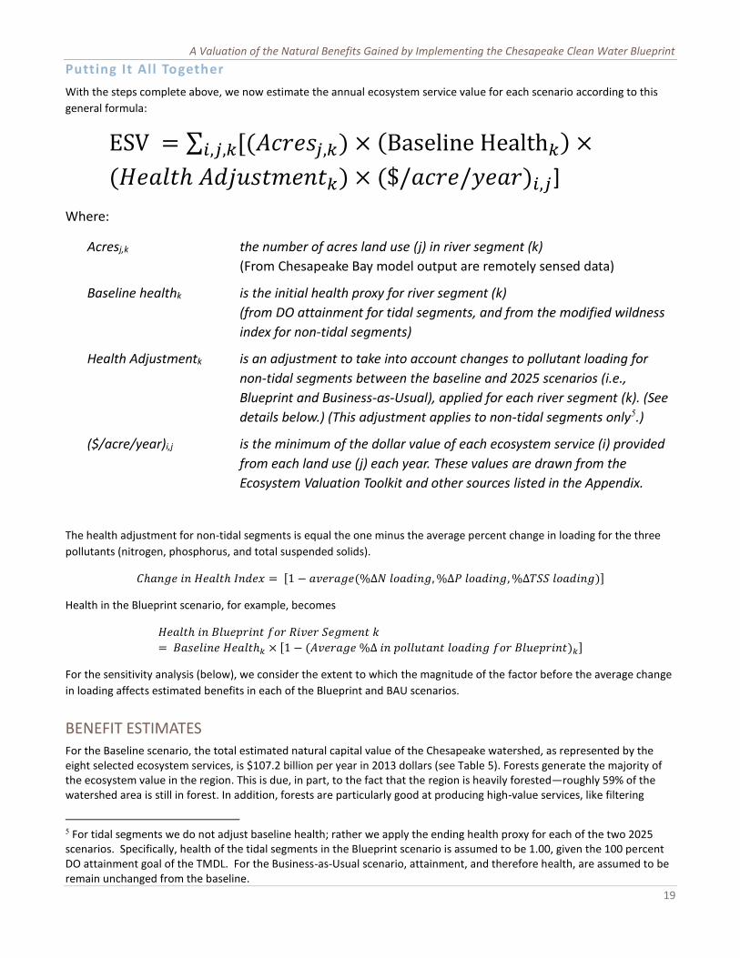
A Valuation of the Natural Benefits Gained by Implementing the Chesapeake Clean Water Blueprint
19
Putting It All Together
With the steps complete above, we now estimate the annual ecosystem service value for each scenario according to this
general formula:
ESV = ∑ [(𝐴𝑐𝑟𝑒𝑠𝑗,𝑘) × (Baseline Health𝑘) ×𝑖,𝑗,𝑘
(𝐻𝑒𝑎𝑙𝑡ℎ 𝐴𝑑𝑗𝑢𝑠𝑡𝑚𝑒𝑛𝑡𝑘) × ($/𝑎𝑐𝑟𝑒/𝑦𝑒𝑎𝑟)𝑖,𝑗]
Where:
Acresj,k the number of acres land use (j) in river segment (k)
(From Chesapeake Bay model output are remotely sensed data)
Baseline healthk is the initial health proxy for river segment (k)
(from DO attainment for tidal segments, and from the modified wildness
index for non-tidal segments)
Health Adjustmentk is an adjustment to take into account changes to pollutant loading for
non-tidal segments between the baseline and 2025 scenarios (i.e.,
Blueprint and Business-as-Usual), applied for each river segment (k). (See
details below.) (This adjustment applies to non-tidal segments only5.)
($/acre/year)i,j is the minimum of the dollar value of each ecosystem service (i) provided
from each land use (j) each year. These values are drawn from the
Ecosystem Valuation Toolkit and other sources listed in the Appendix.
The health adjustment for non-tidal segments is equal the one minus the average percent change in loading for the three
pollutants (nitrogen, phosphorus, and total suspended solids).
𝐶ℎ𝑎𝑛𝑔𝑒 𝑖𝑛 𝐻𝑒𝑎𝑙𝑡ℎ 𝐼𝑛𝑑𝑒𝑥 = [1 − 𝑎𝑣𝑒𝑟𝑎𝑔𝑒(%∆𝑁 𝑙𝑜𝑎𝑑𝑖𝑛𝑔, %∆𝑃 𝑙𝑜𝑎𝑑𝑖𝑛𝑔, %∆𝑇𝑆𝑆 𝑙𝑜𝑎𝑑𝑖𝑛𝑔)]
Health in the Blueprint scenario, for example, becomes
𝐻𝑒𝑎𝑙𝑡ℎ 𝑖𝑛 𝐵𝑙𝑢𝑒𝑝𝑟𝑖𝑛𝑡 𝑓𝑜𝑟 𝑅𝑖𝑣𝑒𝑟 𝑆𝑒𝑔𝑚𝑒𝑛𝑡 𝑘
= 𝐵𝑎𝑠𝑒𝑙𝑖𝑛𝑒 𝐻𝑒𝑎𝑙𝑡ℎ𝑘 × [1 − (𝐴𝑣𝑒𝑟𝑎𝑔𝑒 %∆ 𝑖𝑛 𝑝𝑜𝑙𝑙𝑢𝑡𝑎𝑛𝑡 𝑙𝑜𝑎𝑑𝑖𝑛𝑔 𝑓𝑜𝑟 𝐵𝑙𝑢𝑒𝑝𝑟𝑖𝑛𝑡)𝑘]
For the sensitivity analysis (below), we consider the extent to which the magnitude of the factor before the average change
in loading affects estimated benefits in each of the Blueprint and BAU scenarios.
BENEFIT ESTIMATES For the Baseline scenario, the total estimated natural capital value of the Chesapeake watershed, as represented by the eight selected ecosystem services, is $107.2 billion per year in 2013 dollars (see Table 5). Forests generate the majority of the ecosystem value in the region. This is due, in part, to the fact that the region is heavily forested—roughly 59% of the watershed area is still in forest. In addition, forests are particularly good at producing high-value services, like filtering
5 For tidal segments we do not adjust baseline health; rather we apply the ending health proxy for each of the two 2025 scenarios. Specifically, health of the tidal segments in the Blueprint scenario is assumed to be 1.00, given the 100 percent DO attainment goal of the TMDL. For the Business-as-Usual scenario, attainment, and therefore health, are assumed to be remain unchanged from the baseline.

The Economic Benefits of Cleaning Up the Chesapeake
20
drinking water, reducing flooding, providing aesthetic benefits, and being excellent places for hunting, hiking, and other types of recreation.
These Baseline estimates are generally in line with other studies of the value of natural capital in comparable regions. In a study of the Delaware estuary, an area about one tenth the size of the Chesapeake Bay watershed, Kauffmann (2011) estimated a total of $12.8 billion (adjusted to 2013 dollars) in ecosystem service value. If the Delaware watershed were increased in size to match the Chesapeake watershed, that estimate would come to nearly $137 billion in annual value. Similarly, Mates (2007) finds that the ecosystem service value of New Jersey is about $9.7 billion (adjusted to 2013 dollars). With the Chesapeake Bay watershed being about 8.2 times the size of New Jersey, that assessment would suggest that the ecosystem service value of the Chesapeake Bay watershed would provide approximately $131 billion per year.
TABLE 5: SUMMARY OF ECOSYSTEM SERVICE VALUES FOR SEVEN LAND USES, BY SCENARIO
Baseline Blueprint Business-as-Usual
Land Use ESV (millions of
2013$)
ESV (millions of
2013$)
Change from Baseline
(%)
Difference from BAU
(%)
ESV (millions of
2013$)
Change from Baseline
(%)
Agriculture 12,258 13,434 10% 23% 10,949 -11%
Forest 73,960 86,406 17% 24% 69,639 -6%
Open Water 16,721 24,301 45% 47% 16,549 -1%
Urban Open 3,403 4,706 38% 26% 3,727 10%
Urban Other 11 14 26% 18% 12 7%
Wetland 356 364 2% 34% 270 -24%
Other 467 508 9% 32% 386 -17%
Total $107,176 $129,732 21% 28% $101,531 -5%
Relative to personal income and gross regional product, the $107.2 billion is fairly modest, at least by the standard of Costanza et al. (1997). Costanza et al., using methods similar to those here but without the adjustment for ecosystem health, estimated that the world’s ecosystems produce approximately three times as much value each year as do the world’s economies. For this study, the ratio is much smaller, with the Baseline ecosystem service value being a small fraction (about 1/28) the size of the gross product of the states that contain the Chesapeake region and about one seventh the size of total labor earnings of all the residents of the watershed’s 207 counties (Bureau of Economic Analysis, US Department of Commerce, 2014a, 2014b)6.
The Bay’s ecosystem services estimate is relatively small, based on these comparisons, for a couple of reasons. First, our method entails discounting ecosystem service values according to the land health measure. Second, we have estimated the value of only a subset of ecosystem services. The Delaware, New Jersey, and global studies, by contrast, considered all services and did not adjust for land health or productivity. Third, with respect to the Gross State Product comparison, the gross product of the six states and the District of Columbia includes the entire economic output for three states—New York, Delaware, and West Virginia—that contain less than one sixth of the watershed.
Knowing the baseline value is important: it gives a sense of how much the natural systems of the Chesapeake Bay contribute to the region’s economy on an annual basis. But the true purpose here is to see how much value implementing the Blueprint could add to the natural capital value of the region.
With full implementation of the Phase II WIPs and ultimate achievement of the pollutant loading and water-quality goals of the Clean Water Blueprint, the total value of the Chesapeake watershed is estimated at $129.7 billion annually (using these eight ecosystem services), which is an increase of more than $22.5 billion per year, or roughly 21%, over the Baseline. This
6 These measures are not comparable, of course. Gross regional product and total labor earnings are very different measures, and the six Bay states all contain significant lands outside, as well as within, the Chesapeake watershed. But the comparisons are useful for confirming that the estimates produced here are within the bounds of similar previous studies.

A Valuation of the Natural Benefits Gained by Implementing the Chesapeake Clean Water Blueprint
21
increase is largely due to improved habitat health associated with lower pollutant loads and higher water quality attainment. The remainder is due to some reallocation of land to biomes (e.g., forests) that are relatively more productive from an ecosystem services standpoint. It is not surprising given the distribution of land uses, but is still worth noting that the majority of the benefits of implementing the Blueprint will accrue to “upstream” habitats, rather than to the open water habitat that includes the Chesapeake Bay and its tidal rivers.
TABLE 6: SUMMARY OF ECOSYSTEM SERVICE VALUE FOR EIGHT ECOSYSTEM SERVICES, BY SCENARIO
Baseline Blueprint Business-as-Usual
Ecosystem Service ESV (millions of
2013$)
ESV (millions of
2013$)
Change from Baseline
(%)
Difference from BAU
(%)
ESV (millions of
2013$)
Change from Baseline
(%)
Aesthetic Value 38,446 47,407 23% 29% 36,653 -5%
Climate Stability 5,498 6,508 18% 24% 5,237 -5%
Food Production 12,129 13,313 10% 23% 10,839 -11%
Air Pollution Treatment
3,471 4,061 17% 24% 3,271 -6%
Recreation 3,071 4,099 33% 27% 3,227 5%
Waste Treatment 12,155 16,470 35% 39% 11,827 -3%
Water Regulation 12,386 14,448 17% 24% 11,634 -6%
Water Supply 20,019 23,427 17% 24% 18,843 -6%
Total $107,176 $129,732 21% 28% $101,531 -5%
Under the Business as Usual scenario, by contrast, ecosystem service value could drop somewhat as land continues to be converted from more productive to less productive habitats (from forests to developed urban land, for example), and as land health and water quality continue to deteriorate. Based on the Chesapeake Bay Program’s projections of land use change and of pollution loads, we estimate that total ecosystem service value could drop by $5.6 billion per year (in 2013 dollars) to $101.5 billion beginning in 2025.
Finally, if we compare the Business as Usual result to the Blueprint projections, we estimate that the Blueprint would produce about $28.2 billion more each year in ecosystem service value than under the Business as Usual scenario. Tables 5 and 6 provide summary estimates by land use and by ecosystem service for the three scenarios.
TABLE 7: SUMMARY OF ECOSYSTEM SERVICE VALUE FOR CHESAPEAKE BAY JURISDICTIONS, BY SCENARIO
Baseline Blueprint Business-as-Usual
Jurisdiction ESV (millions of
2013$)
ESV (millions of
2013$)
Change from Baseline
(%)
Difference from BAU
(%)
ESV (millions of
2013$)
Change from Baseline
(%)
Virginia 41,195 49,540 20% 30% 38,006 -8%
Pennsylvania 32,637 38,828 19% 26% 30,810 -6%
Maryland 15,892 20,449 29% 34% 15,209 -4%
New York 10,361 12,276 18% 18% 10,363 0%
West Virginia 6,330 7,668 21% 19% 6,458 2%
Delaware 735 941 28% 43% 659 -10%
District of Columbia 25 29 15% 10% 27 5%
Total $107,176 $129,732 21% 28% $101,531 -5%
If one considers the distribution of ecosystem service value and the benefits of the Blueprint by state (Table 7, Appendix B),
the results are, for the most part commensurate with the distribution of land area in the watershed among the states.
Virginia, which has 33.9% of the acreage would receive 38.2% of the ecosystem service value under the Blueprint scenario

The Economic Benefits of Cleaning Up the Chesapeake
22
($49.5 billion). Pennsylvania, which has a bit more of the acreage (35.2%) would receive a bit less than 30% of the
ecosystem service value ($38.8 billion).
Comparing the Baseline and Blueprint scenario, the states would see gains of between 18 and 29%. (D.C. would gain about
15%.) Differences in these relative gains are due to differences among the states in loadings and land use allocation
stemming from the states and the District’s respective Watershed Implementation Plans.
Ecosystem service value can also be
explored for smaller geographic units,
such as depicted in the map in Figure 8.
This map shows the average value per
acre of all eight ecosystem services
under the Blueprint scenario by river
segment. Lighter shades of green
indicate lower per-acre values. Being a
function of the land use (land cover),
health and per-acre values for different
ecosystem services, total ecosystem
service value does tend to be higher in
river segments with more forest cover
and those near the tidal Bay which,
under the Blueprint scenario, is assumed
to be functioning at full health. Other
high-value river segments are in the main
stem of the Bay, where the area is larger,
and per-acre water supply, aesthetic, and
recreational values are high.
Sensitivity Analysis
As noted above, we assume a linear relationship between our indicators of ecosystem health. While certainly not correct for all relationships, such an assumption provides a straightforward substitute for the myriad possible functional forms that could represent the actual relationships. Even so, it is useful to consider how our estimates could differ under different assumptions. For the sake of simplicity, and because positing some subset of alternative
assumptions would seem no less arbitrary, we consider what the estimated benefits of the Blueprint would be if we had over- or under-estimated by 50% the strength of the relationship between changes in sediment loading and health/productivity.7
7Such an analysis makes sense only for the terrestrial part of the watershed and not for the main stem of the Bay and its tidal tributaries. For those waters, health is either 100% for the Blueprint or unchanged for the BAU scenario, so there was no percentage change involved in the estimation itself.
FIGURE 8: AVERAGE ANNUAL ECOSYSTEM SERVICE VALUE PER ACRE (IN 2013$) UNDER THE
BLUEPRINT SCENARIO
(This map does not show boundaries between river segments.)

A Valuation of the Natural Benefits Gained by Implementing the Chesapeake Clean Water Blueprint
23
In other words, we have asked how the estimates would change if each one percent decrease in pollutant load were to increase land health by only half a percent or, or alternatively, by one and a half percent. This modifies the equation above by inserting a factor of 0.5 and then 1.5 for “Z” in the following equation:
𝐻𝑒𝑎𝑙𝑡ℎ 𝑖𝑛 𝐵𝑙𝑢𝑒𝑝𝑟𝑖𝑛𝑡 𝑓𝑜𝑟 𝑅𝑖𝑣𝑒𝑟 𝑆𝑒𝑔𝑚𝑒𝑛𝑡 = 𝐵𝑎𝑠𝑒𝑙𝑖𝑛𝑒 𝐻𝑒𝑎𝑙𝑡ℎ𝑘 × [1 − 𝒁(𝐴𝑣𝑒𝑟𝑎𝑔𝑒 %∆ 𝑖𝑛 𝑝𝑜𝑙𝑙𝑢𝑡𝑎𝑛𝑡 𝑙𝑜𝑎𝑑𝑖𝑛𝑔 𝑓𝑜𝑟 𝐵𝑙𝑢𝑒𝑝𝑟𝑖𝑛𝑡)𝑘]
And the answer is: “not very much.” For the Blueprint scenario, this procedure yields a range of estimates of total ecosystem service value of $122.2 to $136.7 billion, compared to the estimate above of $129.7 billion. In terms of the benefit or added ecosystem service value of the Blueprint relative to the baseline scenario, the range is $15 to $29.6 billion dollars, compared to the estimate of $22.6 billion. Thus even a major change in assumptions about the relationship between changes in pollutant loads and land health moves the ecosystem service value estimates by less than 6%. (The reason the change is a bit lopsided is that the model does not allow land health to exceed 100%, and for some river segments, multiplying the percent improvement by 1.5 pushed the resulting health index to that limit.)
For the Business as Usual scenario, the range is tighter, from $99.1 to $104 billion, compared to our estimate of $101.5 billion. The reason for the difference in the span of estimates between the BAU and Blueprint scenarios is that in the BAU scenario, about half of the river segments are projected to experience an increase in health anyway (due to BMPs already in place to reduce pollutant loading), and these gains tend to counteract the decreases projected for other segments. In the Blueprint scenario, by contrast, nearly all river segments would see a reduction in pollutant loads (and an increase in health), and very few of the gains in one segment are offset by losses in another.
For both the Blueprint and BAU scenarios, this sensitivity analysis suggests that the assumption of a linear, one-to-one relationship between percent changes in pollutant loading and changes in ecosystem service productivity is fairly robust. Changes to the assumption do not change the absolute estimates by much and the changes certainly do not alter the result that the Blueprint would produce large annual increases in ecosystem service value relative to the Baseline and even larger increases relative to Business as Usual.
Combined with other assumptions designed to make our estimates conservative (e.g., selecting minimum per-acre values and adjusting for land health in the first place), this result gives great confidence that the estimates are both reasonable and useful as low-end estimates for consideration of the overall, net benefit of the Blueprint.
CONCLUSION Natural capital, as the basis for ecosystem service flows, is an important contributor to the Chesapeake Bay region’s economy and quality of life. As these study results suggest, implementing the Chesapeake Clean Water Blueprint could result in important economic benefits relative to today’s conditions and relative to conditions that would be expected to prevail if no further action is taken to reduce pollution of the Chesapeake Bay. These benefits accrue both due to changes in the pattern of land conversion in the region and due to adoption of best management practices that result in reductions of pollutant loads. Both types of change would improve ecosystem service productivity and, assuming stable values for those services, increases in the economic output of the region’s natural capital.
These benefits would naturally be distributed among diverse industries, individuals, and communities throughout and beyond the region. This look at aggregate value of implementing and achieving the Blueprint provides an important perspective on the overall economic contribution of the program. It also gives us a benchmark against which to consider other economic aspects of achieving water quality improvement in the Chesapeake Bay, including the cost of implementing pollution-control measures.

The Economic Benefits of Cleaning Up the Chesapeake
24
WORKS CITED
Anderson, G. D., & Edwards, S. F. (1986). Protecting Rhode Island coastal salt ponds - an economic-assessment of downzoning. Coastal Zone Management Journal, 14, 67–91.
Anderson, R. S., Brubacher, L. L., Calvo, L. R., Unger, M. A., & Burreson, E. M. (1998). Effects of tributyltin and hypoxia on the progression of Perkinsus marinus infections and host defence mechanisms in oyster, Crassostrea virginica (Gmelin). Journal of Fish Diseases, 21(5), 371–379. doi:10.1046/j.1365-2761.1998.00128.x
Aplet, G. H. (1999). On the nature of wildness: exploring what wilderness really protects. Denver University Law Review, 76(2), 347–67.
Aplet, G. H., Wilbert, M., & Morton, P. (2005). Wilderness attributes and the state of the National Wilderness Preservation System. In H. K. Cordell, J. C. Bergstrom, & J. M. Bowker (Eds.), The Multiple Values of Wilderness. State College, Pennsylvania: Venture Publishing, Inc.
Aplet, G., Thomson, J., & Wilbert, M. (2000). Indicators of wildness: using attributes of the land to assess the context of wilderness. In S. F. McCool, D. N. Cole, W. T. Borrie, & J. O’Loughlin (Eds.), Wilderness Science in a Time of Change (Vol. Wilderness within the context of larger systems, RMRS-P-15-VOL-2, pp. 89–98). US Department of Agriculture, Forest Service, Rocky Mountain Research Station.
Armstrong, D., Rooper, C., & Gunderson, D. (2003). Estuarine Production of juvenile Dungeness Crab and Contribution to the Oregon-Washington Coastal Fishery. Estuaries, 26(4), 1174–1188.
Balmford, A., Fisher, B., Green, R. E., Naidoo, R., Strassburg, B., Kerry Turner, R., & Rodrigues, A. S. L. (2010). Bringing Ecosystem Services into the Real World: An Operational Framework for Assessing the Economic Consequences of Losing Wild Nature. Environmental and Resource Economics, 48(2), 161–175. doi:10.1007/s10640-010-9413-2
Balmford, A., Rodrigues, A., Walpole, M., Brink, P., Kettunen, M., de Groot, R., & Cambridge, U. (2013). The Economics of Biodiversity and Ecosystems: Scoping the Science. (Vol. 8 SRC - GoogleScholar). Retrieved from http://ec.europa.eu/environment/nature/biodiversity/economics/teeb_en.htm
Batker, D., Kocian, M., McFadden, J., & Schmidt, R. (2010). Valuing The Puget Sound Basin: Revealing Our Best Investments 2010 (p. 102). Tacoma, WA: Earth Economics.
Beck, M. W., Heck, K. L., Able, K. W., Childers, D. L., Eggleston, D. B., Gillanders, B. M., … Weinstein, M. P. (2001). The Identification, Conservation, and Management of Estuarine and Marine Nurseries for Fish and Invertebrates. BioScience, 51(8), 633–641. doi:10.1641/0006-3568(2001)051[0633:TICAMO]2.0.CO;2
Bell, F. W. (1989). Application of wetland valuation theory to commercial and recreational fisheries in Florida (p. 148). Florida Sea Grant Program.
Bergstrom, J. C., Dillman, B. L., & Stoll, J. R. (1985). Public Environmental Amenity Benefits Of Private Land: The Case Of Prime Agricultural Land. Southern Journal of Agricultural Economics, 17(01). Retrieved from http://ideas.repec.org/a/ags/sojoae/29361.html
Bergstrom, J. C., Stoll, J. R., Titre, J. P., & Wright, V. L. (1990). Economic value of wetlands-based recreation. Ecological Economics, 2(2), 129–147. doi:10.1016/0921-8009(90)90004-E

A Valuation of the Natural Benefits Gained by Implementing the Chesapeake Clean Water Blueprint
25
Bockstael, N. E., McConnell, K. E., & Strand, I. E. (1988). Benefits from Improvements in Chesapeake Bay Water Quality. Washington, DC: U.S. Environmental Protection Agency, Volume III.
Boyd, J., & Banzhaf, S. (2006). What Are Ecosystem Services: The Need for Standardized Environmental Accounting Units. Washington, D.C.: Resources for the Future. Retrieved from http://www.rff.org/Documents/RFF-DP-06-02.pdf
Boyd, J. W. (2011). The risk of ecosystem service losses. Resources(Summer), 33–37.
Boynton, W. R., Hagy, J. D., Cornwell, J. C., Kemp, W. M., Greene, S. M., Owens, M., … Larsen, R. K. (2008). Nutrient Budgets and Management Actions in the Patuxent River Estuary, Maryland. Coastal and Estuarine Research Federation.
Breaux, A., Farber, S., & Day, J. (1995). Using Natural Coastal Wetlands Systems for Wastewater Treatment: An Economic Benefit Analysis. Journal of Environmental Management, 44(3), 285–291. doi:10.1006/jema.1995.0046
Brenner Guillermo, J. (2007, May 4). Valuation of ecosystem services in the catalan coastal zone [info:eu-repo/semantics/doctoralThesis]. Retrieved May 18, 2014, from http://www.tdx.cat/handle/10803/6398
Briceno, T., & Klochmer, J. (2014, March 18). Ecosystem Valuation Toolkit: Custom Data Pull for the Chesapeake Bay Region. Earth Economics.
Buchheister, A., Bonzek, C. F., Gartland, J., & Latour, R. J. (2013). Patterns and drivers of the demersal fish community of Chesapeake Bay. Marine Ecology Progress Series, 481, 161–180. doi:10.3354/meps10253
Bureau of Economic Analysis, US Department of Commerce. (2014a). Gross Domestic Product. Retrieved August 5, 2014, from http://www.bea.gov/regional/
Bureau of Economic Analysis, US Department of Commerce. (2014b). Regional Economic Information System. Retrieved March 6, 2014, from http://www.bea.gov/regional/
Burt, O. R., & Brewer, D. (1971). Estimation of Net Social Benefits from Outdoor Recreation. Econometrica, 39(5), 813. doi:10.2307/1909581
Bytnerowicz, A., Fenn, M., McNulty, S., Yuan, F., Pourmokhtarian, A., Driscoll, C., & Meixner, T. (2013). Interactive Effects of Air Pollution and Climate Change on Forest Ecosystems in the United States. In Developments in Environmental Science (Vol. 13, pp. 333–369). Elsevier. Retrieved from http://linkinghub.elsevier.com/retrieve/pii/B9780080983493000165
Chesapeake Bay Foundation. (2007). Climate Change and the Chesapeake Bay: Challenges, Impacts, and the Multiple Benefits of Agricultural Conservation Work. Retrieved from http://www.cbf.org/document.doc?id=140
Chesapeake Bay Program. (2012). Chesapeake Bay Program. Retrieved November 9, 2013, from http://www.chesapeakebay.net/
Chesapeake Bay Stock Assessment Committee. (2013). 2013 Chesapeake Bay Blue Crab Advisory Report (p. 12). Retrieved from http://www.chesapeakebay.net/documents/Final_CBSAC_Advisory_Report_2013_.pdf
Claggett, P. (2013, December 23). Personal Communication re: NLCD and Chesapeake Bay land cover adjustments.

The Economic Benefits of Cleaning Up the Chesapeake
26
Cordell, H. K., & Bergstrom, J. C. (1993). Comparison of recreation use values among alternative reservoir water level management scenarios. Water Resources Research, 29(2), 247–258. doi:10.1029/92WR02023
Costanza, R., d’ Arge, R., De Groot, R., Farber, S., Grasso, M., Hannon, B., … Paruelo, J. (1997). The value of the world’s ecosystem services and natural capital. Nature, 387(6630), 253–260.
Costanza, R., d’ Arge, R., Farber, S., Grasso, M., deGroot, R., Hannon, B., & van den Belt, M. (1997). The Value of the World’s Ecosystem Services and Natural Capital. Nature, 387, 253–260.
Costanza, R., Farber, S. C., & Maxwell, J. (1989). Valuation and management of wetland ecosystems. Ecological Economics, 1(4), 335–361. doi:10.1016/0921-8009(89)90014-1
Creel, M., & Loomis, J. (1992). Recreation value of water to wetlands in the San Joaquin Valley: Linked multinomial logit and count data trip frequency models. Water Resources Research, 28(10), 2597–2606. doi:10.1029/92WR01514
Croke, K., Fabian, R., & Brenniman, G. (1986). Estimating the Value of Improved Water Quality in an Urban River System. Journal of Environmental Systems, 16(1), 13–24. doi:10.2190/RDE4-N1UM-2J2P-07UX
De Groot, R. S., Wilson, M. A., & Boumans, R. M. (2002). A typology for the classification, description, and valuation of ecosystem functions, goods, and services. Ecological Economics, 41, 393–408.
Deegan, L. A., Johnson, D. S., Warren, R. S., Peterson, B. J., Fleeger, J. W., Fagherazzi, S., & Wollheim, W. M. (2012). Coastal eutrophication as a driver of salt marsh loss. Nature, 390, 388–392.
Diaz, R., Rabalais, N. ., & Breitburg, D. . (2012). Agriculture’s Impact on Aquaculture: Hypoxia and Eutrophication in Marine Waters. Retrieved from http://www.oecd.org/tad/sustainable-agriculture/49841630.pdf
ECONorthwest. (2011). Economic Benefits of Green Infrastructure, Chesapeake Bay Region.pdf. Retrieved from http://www.econw.com/media/ap_files/ECONorthwest_Publication_Green-Infrastructure-Chesapeake_2011-12.pdf
Esposito, V. (2009). Promoting ecoliteracy and ecosystem management for sustainablity through ecological economic tools. (Doctoral). University of Vermont. Retrieved from https://library.uvm.edu/jspui/handle/123456789/193
Esposito, V., Phillips, S., Boumans, R., Moulaert, A., & Boggs, J. (2011). Climate change and ecosystem services: The contribution of and impacts on federal public lands in the United States. In Watson, Alan; Murrieta-Saldivar, Joaquin; McBide, Brooke, comps. Science and stewardship to protect and sustain wilderness values. Merida, Yucatan, Mexico.: USDA Forest Service, Rocky Mountain Research Station. Retrieved from http://www.fs.fed.us/rm/pubs/rmrs_p064/rmrs_p064_155_164.pdf
Farley, J. (2012). Ecosystem services: The economics debate. Ecosystem Services, 1(1), 40–49.
Flores, L., Harrison-Cox, J., Wilson, S., & Batker, D. (2013). Nature’s Value in Clallam County: The Economic Benefits of FeederBluffs and 12 Other Ecosystems. Tacoma, WA: Earth Economics.
Fry, J., Xian, G., Jin, S., Dewitz, J., Homer, C., Yang, L., … Wickham, J. (2011). NLCD_September2011PERS.pdf. Photogrammetric Engineering & Remote Sensing, 77(9), 858–864.

A Valuation of the Natural Benefits Gained by Implementing the Chesapeake Clean Water Blueprint
27
Groundwater Protection Council. (2007). Ground Water Report to the Nation: A Call to Action. Retrieved from http://www.gwpc.org/sites/default/files/GroundWaterReport-2007-.pdf
Grove, M. (2004). Demographic and Socioeconomic Research Team: Research Highlights 2004 (Baltimore Ecosystem Study).
Hairston-Strang, A. (2010). Assessing Forest Buffer Functions after Five Years. Final Report to Harry R. Hughes Center for Agro-Ecology, Inc. Annapolis, MD: Maryland Department of Natural Resources, Forest Service. Retrieved from http://www.dnr.state.md.us/irc/docs/00016298.pdf
Hayes, K. M., Tyrrell, T. J., & Anderson, G. (1992). Estimating the benefits of water quality improvements in the Upper Narragansett Bay. Marine Resource Economics, 7, 75–85.
Heck, K. L., Hays, G., & Orth, R. J. (2003). Critical evaluation of the nursery role hypothesis for seagrass meadows. Marine Ecology Progress Series, 253, 123–136.
Heisler, G. (1986). Energy Savings with Trees. Journal of Arboriculture 12, No. 5, 113–125.
Hicks, R., Haab, T. C., & Lipton, D. (2004). Estimating the economic benefits of oyster reef restoration and marine preserve establishment in the lower Chesapeake Bay. Chesapeake Bay Foundation.
Higgins, C. B., Stephenson, K., & Brown, B. L. (2011). Nutrient Bioassimilation Capacity of Aquacultured Oysters: Quantification of an Ecosystem Service. Journal of Environment Quality, 40(1), 271–277. doi:10.2134/jeq2010.0203
Hughes, Z. (2006). Ecological and economics assessment of potential eelgrass expansion Hugheseat Sucia Island (Term Paper). University of Washington.
Jenkins, W. A., Murray, B. C., Kramer, R. A., & Faulkner, S. P. (2010). Valuing ecosystem services from wetlands restoration in the Mississippi Alluvial Valley. Ecological Economics, 69(5), 1051–1061. doi:10.1016/j.ecolecon.2009.11.022
Jentes Banicki, J. (2006). Hot Commodity: Cleaner Water Increases Lake Erie Property Values. Twineline, Vol 28(No. 3-4). Retrieved from http://ohioseagrant.osu.edu/_documents/twineline/v28i4.pdf
Johan A. Mistiaen, I. E. S. (2003). Effects of environmental stress on blue crab ( Callinectes sapidus ) harvests in Chesapeake Bay tributaries, 26(2), 316–322. doi:10.1007/BF02695970
Johnson, G. (2010, March). AIRES. Presented at the AIRES (Artificial Intelligence for Ecosystem Services) Workshop, Gund Insitute, University of Vermont.
Johnston, M. (2014a). Chesapeake Bay Land Change Model. US Environmental Protection Agency, Chesapkeake Bay Program.
Johnston, M. (2014b). Chesapeake Bay Program Partnership Watershed Model Phase 5.3.2. US Environmental Protection Agency, Chesapkeake Bay Program.
Johnston, R. J., Opaluch, J. J., Grigalunas, T. A., & Mazzotta, M. J. (2001). Estimating Amenity Benefits of Coastal Farmland. Growth and Change, 32(3), 305–325. doi:10.1111/0017-4815.00161
Kahn, J. R., & Buerger, R. B. (1994). Valuation and the Consequences of Multiple Sources of Environmental Deterioration: the Case of the New York Striped Bass Fishery. Journal of Environmental Management, 40(3), 257–273. doi:10.1006/jema.1994.1019
Kareiva, P., Tallis, H. R., Daily, G. C., & Polasky, S. (2011). Natural Capital: Theory and Practice of Mapping Ecosystem Services. Oxford: Oxford University Press.

The Economic Benefits of Cleaning Up the Chesapeake
28
Kauffman, G., Homsey, A., Chatterson, S., McVey, E., & Mack, S. (2011). Economic Value of the Delaware Estuary Watershed-Summary Document (p. 82). Newark, DE: University of Delaware’s Institute for Public Administration. Retrieved from http://udspace.udel.edu/handle/19716/9772
Kauffmann, Gerald, Homsey, Anadrew, McVey, Erin, Mack, Stacey, & Chatterson, Sarah. (2011). Socioeconomic Value of the Chesapeake Bay Watershed in Delaware (p. 45). Newark, DE: University of Delaware, Institute for Public Administration.
Kemp, W. M., Boynton, W. R., Adolf, J. E., Boesch, D. F., Boicourt, W. C., Brush, G., … others. (2005). Eutrophication of Chesapeake Bay: historical trends and ecological interactions. Marine Ecology Progress Series, 303(21), 1–29.
Kenneth Mcconnell, N. E. B. (n.d.). Measuring the Benefits of Improvements in Water Quality: The Chesapeake Bay. Marine Resource Economics, 06(1).
Kildow, J. T. (2006). The Influence of Coastal Preservation and Restoration on Coastal Real Estate Values, In, The Economic and Market Value of Coasts and Estuaries. Restore America’s Estuaries. Retrieved from http://www.habitat.noaa.gov/pdf/economic_and_market_valueofcoasts_and_estuaries.pdf
Kildow, J. T., Colgan, C., Kite-Powell, H., Shivendu, S., & Tindall, R. (2004). Estimates of water-quality related values and other relevant data for Long Island Sound. Long Island Sound Study.
Kline, J. D., & Swallow, S. K. (1998). The demand for local access to coastal recreation in southern New England. Coastal Management, 26(3), 177–190. doi:10.1080/08920759809362351
Knoche, S., & Lupi, F. (2007). Valuing deer hunting ecosystem services from farm landscapes. Ecological Economics, 64(2), 313–320. doi:10.1016/j.ecolecon.2007.07.023
Kreutzwiser, R. (1981). The Economic Significance of the Long Point Marsh, Lake Erie, as a Recreational Resource. Journal of Great Lakes Research, 7(2), 105–110. doi:10.1016/S0380-1330(81)72034-3
Lindsey, B. D., Phillips, S. W., Donnelly, C. A., Speiran, G. K., Plummer, L. N., Bohlke, J.-K., … Busenberg, E. (2003). Residence Times and Nitrate Transport in Ground Water Discharging to Streams in the Chesapeake Bay Watershed (No. Water-Resources Investigations Report 03-4035) (p. 136). US Geological Survey. Retrieved from http://pa.water.usgs.gov/reports/wrir03-4035.pdf
Lipton, D. (2004). The value of improved water quality to Chesapeake Bay boaters. Marine Resource Economics, 19(2), 265–270.
Lipton, D. (2009). Economic Benefits of a Restored Oyster Fishery in Chesapeake Bay. Journal of Shellfish Research, (May 2008), 619–623. doi:10.2983/0730-8000(2008)27[619:EBOARO]2.0.CO;2
Lipton, D., & Hicks, R. (2003). The cost of stress: Low dissolved oxygen and economic benefits of recreational striped bass (Morone saxatilis) fishing in the Patuxent River. Estuaries, 26(2), 310–315. doi:10.1007/BF02695969
Lipton, D., Murray, T., & Kirkley, J. (2009). Assessment of the Economic Impacts of Recreational Boating in the City of Hampton (No. VSG-09-02). Virginia Institute of Marine Science. Retrieved from http://web.vims.edu/adv/econ/MRR2009_2.pdf
Liu, Z. (2006). Water Quality Simulation and Economic Valuation of Riparian Land-use Changes. University of Cincinnati.

A Valuation of the Natural Benefits Gained by Implementing the Chesapeake Clean Water Blueprint
29
Lotter, D. W., Seidel, R., & Liebhardt, W. (2003). The performance of organic and conventional cropping systems in an extreme climate year. American Journal of Alternative Agriculture, 18(03), 146–154.
Mathews, L. G., Homans, F. R., & Easter, K. W. (2002). Estimating the Benefits of Phosphorus Pollution Reductions: An Application in the Minnesota River1. JAWRA Journal of the American Water Resources Association, 38(5), 1217–1223. doi:10.1111/j.1752-1688.2002.tb04343.x
Mazzotta, M. J. (1996). Measuring public values and priorities for natural resources: An application to the Peconic Estuary system. Dissertations and Master’s Theses (Campus Access), 1–272.
Mcpherson, G. E. (1992). Accounting for benefits and costs of urban greenspace. Landscape and Urban Planning, 22(1), 41–51. doi:10.1016/0169-2046(92)90006-L
McPherson, G., Scott, K., & Simpson, J. (1998). Estimating cost effectiveness of residential yard trees for improving air quality in Sacramento, California, using existing models. Atmospheric Environment, 32(1), 75–84. doi:10.1016/S1352-2310(97)00180-5
Mullen, J. K., & Menz, F. C. (1985). The Effect of Acidification Damages on the Economic Value of the Adirondack Fishery to New York Anglers. American Journal of Agricultural Economics, 67(1), 112. doi:10.2307/1240830
Needelman, B. A., Crooks, S., Shumway, C. A., Titus, J. G., Takacs, R., & Hawkes, J. E. (2012). Restore-Adapt-Mitigate: Responding to Climate Change Through Coastal Habitat Restoration in Restore America’s Estuaries. Restore America’s Estuaries. Retrieved from https://www.estuaries.org/images/stories/RAE_Restore-Adapt-Mitigate_Climate-Chg-Report.pdf
Neville, L. R. (1996). Urban Watershed Management: The Role of Vegetation. State University of New York. College of Environmental Science and Forestry, Syracuse.
Newell, R. I. E., Fisher, T. R., Holyoke, R. R., & Cornwell, J. C. (2005). Influence of Eastern Oysters on Nitrogen and Phosphorus Regeneration in Chesapeake Bay, USA. In R. F. Dame & S. Olenin (Eds.), The Comparative Roles of Suspension-Feeders in Ecosystems (pp. 93–120). Springer Netherlands. Retrieved from http://link.springer.com/chapter/10.1007/1-4020-3030-4_6
NOAA. (2014). Annual Commercial Landing Statistics [Data]. Retrieved August 11, 2014, from http://www.st.nmfs.noaa.gov/st1/commercial/landings/annual_landings.html
Novak, D. J., Hoehn, R. E., Crane, D. E., Walton, J. T., & Stevens, J. C. (2006). Assessing Urban Forest Effects and Values: Washington, DC’s Urban Forest. U.S. Forest Service. Retrieved from http://caseytrees.org/wp-content/uploads/2012/02/report-2006-09-ufore2004.pdf
Nunes, P. A. L. D., & Bergh, J. C. J. M. van den. (2004). Can People Value Protection against Invasive Marine Species? Evidence from a Joint TC–CV Survey in the Netherlands. Environmental and Resource Economics, 28(4), 517–532. doi:10.1023/B:EARE.0000036777.83060.b6
Opaluch, J. J., Grigalunas, T. A., Diamantedes, J., Mazzotta, M., & Johnston, R. (1999). Recreational and resource economic values for the Peconic Estuary, prepared for the Peconic Estuary Program. Peconic Esturary Program.
Philadelphia Water Department. (2009). Green City, Clean Waters: The City of Philadelphia’s Program for Combined Sewer Overflow Control—A Long Term Control Plan Update. Philadelphia Water Department. Retrieved from www.phillywatersheds.org/ltcpu/LTCPU_Summary_LoRes.pdf

The Economic Benefits of Cleaning Up the Chesapeake
30
Pimentel, D., Harvey, C., Resosudarmo, P., Sinclair, K., Kurz, K., McNair, M., … Saffouri, R. (2003). Environmental and Economic Costs of Soil Erosion and Conservation Benefits. Science, Vol. 267(No 5201).
Poff, N. L., Allan, J. D., Bain, M. B., Karr, J. R., Prestegaard, K. L., Richter, B. D., … Stromberg, J. C. (1997). The natural flow regime. BioScience, 47, 766–784.
Pompe, J. J., & Rinehart, J. R. (1995). Beach Quality and the Enhancement of Recreational Property Values. Journal of Leisure Research, 27(2). Retrieved from http://js.sagamorepub.com/jlr/article/view/866
Poor, P. J., Pessagno, K. L., & Paul, R. W. (2007). Exploring the hedonic value of ambient water quality: A local watershed-based study. Ecological Economics, 60(4), 797–806. doi:10.1016/j.ecolecon.2006.02.013
Power, T. M. (1996). Lost Landscapes and Failed Economies: The Search for a Value of Place. Covelo, CA: Island Press.
Prince, R. (n.d.). Estimating individual recreation benefits under congestion and uncertainty.
Qiu, Z., Prato, T., & Boehrn, G. (2006). Economic Valuation of Riparian Buffer and Open Space in a Suburban Watershed1. JAWRA Journal of the American Water Resources Association, 42(6), 1583–1596. doi:10.1111/j.1752-1688.2006.tb06022.x
Raphael, C. N., & Jaworski, E. (1979). Economic value of fish, wildlife, and recreation in Michigan's coastal wetlands. Coastal Zone Management Journal, 5(3), 181–194. doi:10.1080/08920757909361805
Reid, W. V., Mooney, H. A., Cooper, A., Capistrano, D., Carpenter, S. R., Chopra, K., … Zurek, M. B. (2005). Millennium Ecosystem Assessment, Ecosystems and Human Well-being: Synthesis. Washington, DC: Island Press.
Ribaudo, M. O., & Epp, D. J. (1984). The Importance of Sample Discrimination in Using the Travel Cost Method to Estimate the Benefits of Improved Water Quality. Land Economics, 60(4), 397–403.
Rosenberger, A., & Convery, K. (2008). Assessment of the Virginia Birding and Wildlife Trail. Retrieved from http://www.dgif.virginia.gov/vbwt/Assesment-of-the-VBWT-2003Version-CMI-FINAL-REPORT.pdf
Sandra S. Batie, J. R. W. (1978). Economic values attributable to Virginia’s coastal wetlands as input in oyster production. Southern Journal of Agricultural Economics, 10(01).
Shafer, E. L., Carline, R., Guldin, R. W., & Cordell, H. K. (1993). Economic amenity values of wildlife: Six case studies in Pennsylvania. Environmental Management, 17(5), 669–682. doi:10.1007/BF02393728
Shenk, G. (2014, July 21). Explanation of dissolved oxygen stoplight data (conversation with Beth McGee).
Sprague, E., Burke, D., Clagett, S., & Todd, A. (2006). The State of Chesapeake Forests. Retrieved from http://www.na.fs.fed.us/watershed/pdf/socf/Full%20Report.pdf

A Valuation of the Natural Benefits Gained by Implementing the Chesapeake Clean Water Blueprint
31
Stynes, D. (2012). Economic Contribution of the Chesapeake Bay Gateways and Watertrails Network to Local Economies. Retrieved from http://www.baygateways.net/pubs/CBGN_Econ_Study_Tech_Report_FINAL_January_2012.pdf
Sutherland, D., & Pennington, R. J. (1999). Washington Aqueduct Sediment Discharges Report of Panel Recommendations. Prepared by D. Sutherland for the Chesapeake Bay Field Office, US Fish and Wildlife Service. Annapolis, Maryland. Retrieved from http://www.fws.gov/chesapeakebay/pdf/aque99.pdf
Swedeen, P., & Pittman, J. (2007). An ecological economic assessment of King County’s flood hazard management plan. Tacomo, WA: Earth Economics.
Sweeney, B. W., Bott, T. L., Jackson, J. K., Kaplan, L. A., Newbold, J. D., Standley, L. J., … Horwitz, R. J. (2004). Riparian deforestation, stream narrowing, and loss of stream ecosystem services. Proceedings of the National Academy of Sciences of the United States of America, 101(39), 14132–14137. doi:10.1073/pnas.0405895101
The restoration of Lititz Run: Despite black marks, waterway benefits from groundbreaking inroads by a local coalition. (2008, November 13). Lancaster New Era. Retrieved from http://www.warwicktownship.org/sites/warwickpa/files/file/file/restoration_of_lititz_run_article_11-13-08.pdf
The Trust for Public Land. (2010). The economic benefits and fiscal impact of parks and open space in Nassau and Suffolk Counties, New York (p. 48). Retrieved from http://cloud.tpl.org/pubs/ccpe--nassau-county-park-benefits.pdf
Thibodeau, F. R., & Ostro, B. D. (1981). An economic analysis of wetland protection. Journal of Environmental Management, 19, 72–79.
U.S. Department of Agriculture. (2007). NASS - National Agricultural Statistic Service.
US EPA. (2010). Chesapeake Bay Total Maximum Daily Load for Nitrogen, Phosphorus, and Sediment. Environmental Protection Agency. Retrieved from http://www.epa.gov/reg3wapd/tmdl/ChesapeakeBay/tmdlexec.html
US EPA. (2014, February). The Economic Benefits of Green Infrastructure A Case Study of Lancaster, PA. Retrieved from http://owpubauthor.epa.gov/infrastructure/greeninfrastructure/upload/CNT-Lancaster-Report-508.pdf
US EPA Chesapeake Bay Program. (2014). Chesapeake Bay Program: Water Quality Standards Achievement. Retrieved August 5, 2014, from http://www.chesapeakebay.net/indicators/indicator/achievement_of_chesapeake_bay_water_quality_standards
Van der Ploeg, S., Wang, Y., Gebre Weldmichael, T., & De Groot, R. S. (2010). The TEEB Valuation Database – a searchable database of 1310 estimates of monetary values of ecosystem services. (Excel database and accompanying documentation). Wageningen, The Netherlands: Foundation for Sustainable Development. Retrieved from http://www.es-partnership.org/esp/80763/5/0/50
Weber, T. (2007). Ecosystem services in Cecil County’s green infrastructure: Technical Report for the Cecil County Green Infrastructure Plan (White Paper) (p. 32). Annapolis, MD: The Conservation Fund. Retrieved from

The Economic Benefits of Cleaning Up the Chesapeake
32
http://www.ccgov.org/uploads/PlanningAndZoning/General/CecilCoMD_TechReport%20-%20Ecosystem%20services.pdf
Whitehead, J. C. (1990). Measuring willingness-to-pay for wetlands preservation with the contingent valuation method. Wetlands, 10(2), 187–201. doi:10.1007/BF03160832
Whitehead, J. C., Groothuis, P. A., Southwick, R., & Foster-Turley, P. (2009). Measuring the economic benefits of Saginaw Bay coastal marsh with revealed and stated preference methods. Journal of Great Lakes Research, 35(3), 430–437. doi:10.1016/j.jglr.2009.03.005
Whitehead, J. C., Hoban, T. L., & Clifford, W. B. (1997). Economie analysis of an estuarine quality improvement program: The Albemarle-Pamlico system. Coastal Management, 25(1), 43–57. doi:10.1080/08920759709362309
Wilbert, M. (2013). Indicators of Wildness for the Chesapeake Bay Watershed.

APPENDIX A: PER-ACRE ECOSYSTEM SERVICE VALUE
Candidate per-acre values for Land-Use and Ecosystem Service Combinations A
(All values are in 2013 $)
Land Use
Ecosystem
Service
Min
$/Acre
Midpoint
$/Acre
Maximum
$/Acre Note SourceD
Agriculture Aesthetic
Information
$34.45 $61.13 $87.81 B (Bergstrom, Dillman, &
Stoll, 1985)
Agriculture Aesthetic
Information
$1,833.47 $1,833.47 $1,833.47 B (R. J. Johnston, Opaluch,
Grigalunas, & Mazzotta,
2001)
Agriculture Food $2,381.76 $2,381.76 $2,381.76 (Kauffmann, Gerald et al.,
2011)
Agriculture Recreation $2.13 $3.53 $4.94 B (Knoche & Lupi, 2007)
Forest Aesthetic
Information
$1,831.47 $2,639.46 $3,447.46 B (Mazzotta, 1996)
Forest Aesthetic
Information
$4,561.17 $4,561.17 $4,561.17 B (Opaluch, Grigalunas,
Diamantedes, Mazzotta, &
Johnston, 1999)
Forest Climate
Stability
$318.60 $318.60 $318.60 B (Flores, Harrison-Cox,
Wilson, & Batker, 2013)
Forest Air Pollution
Treatment
$214.68 $214.68 $214.68 (Weber, 2007)
Forest Recreation $2.74 $249.33 $495.92 B (Shafer, Carline, Guldin, &
Cordell, 1993)
Forest Recreation $36.54 $40.66 $44.78 B (Prince, n.d.)
Forest Waste
Treatment
$261.54 $262.09 $262.63 B (Liu, 2006)
Forest Waste
Treatment
$6,174.59 $6,174.59 $6,174.59 B (Liu, 2006)
Forest Water
Regulation
$763.20 $763.20 $763.20 (Weber, 2007)
Forest Water Supply $1,236.40 $1,236.40 $1,236.40 (Weber, 2007)
Open water Aesthetic
Information
$3,848.73 $7,707.34 $11,565.96 B (Opaluch et al., 1999)

The Economic Benefits of Cleaning Up the Chesapeake
A-2
Candidate per-acre values for Land-Use and Ecosystem Service Combinations A
(All values are in 2013 $)
Land Use
Ecosystem
Service
Min
$/Acre
Midpoint
$/Acre
Maximum
$/Acre Note SourceD
Open water Food $25.35 $82.37 $139.40 B (Armstrong, Rooper, &
Gunderson, 2003).
Open water Food $67.22 $67.22 $67.22 B (Judith T Kildow, Colgan,
Kite-Powell, Shivendu, &
Tindall, 2004)
Open water Food $750.20 $750.20 $750.20 B (Kahn & Buerger, 1994)
Open water Food $3,447.46 $5,548.26 $7,649.06 B (Mazzotta, 1996)
Open water Food $29,174.11 $29,174.11 $29,174.11 B (Douglas Lipton, 2009)
Open water Recreation $10.00 $51.73 $93.46 B (Whitehead, Hoban, &
Clifford, 1997)
Open water Recreation $108.33 $208.30 $308.27 B (Opaluch et al., 1999)
Open water Recreation $152.88 $526.19 $899.51 B (Cordell & Bergstrom,
1993)
Open water Recreation $185.17 $301.05 $416.93 B (Opaluch et al., 1999)
Open water Recreation $204.04 $328.99 $453.94 B (Judith T Kildow et al.,
2004)
Open water Recreation $299.32 $364.77 $430.21 B (Mullen & Menz, 1985)
Open water Recreation $437.31 $437.31 $437.31 B (Hicks, Haab, & Lipton,
2004)
Open water Recreation $652.38 $699.76 $747.14 B (Ribaudo & Epp, 1984)
Open water Recreation $1,230.03 $1,790.48 $2,350.93 B (Hayes, Tyrrell, &
Anderson, 1992)
Open water Recreation $2,669.01 $2,763.21 $2,857.41 B (Burt & Brewer, 1971)
Open water Recreation $4,087.27 $9,849.15 $15,611.04 B (Shafer et al., 1993)
Open water Recreation $13,614.87 $13,614.87 $13,614.87 B (Mathews, Homans, &
Easter, 2002)
Open water Waste
Treatment
$3,609.10 $3,609.10 $3,609.10 B (Douglas Lipton, 2004)
Open water Water Supply $81.35 $112.86 $144.37 B (Kenneth Mcconnell, n.d.)
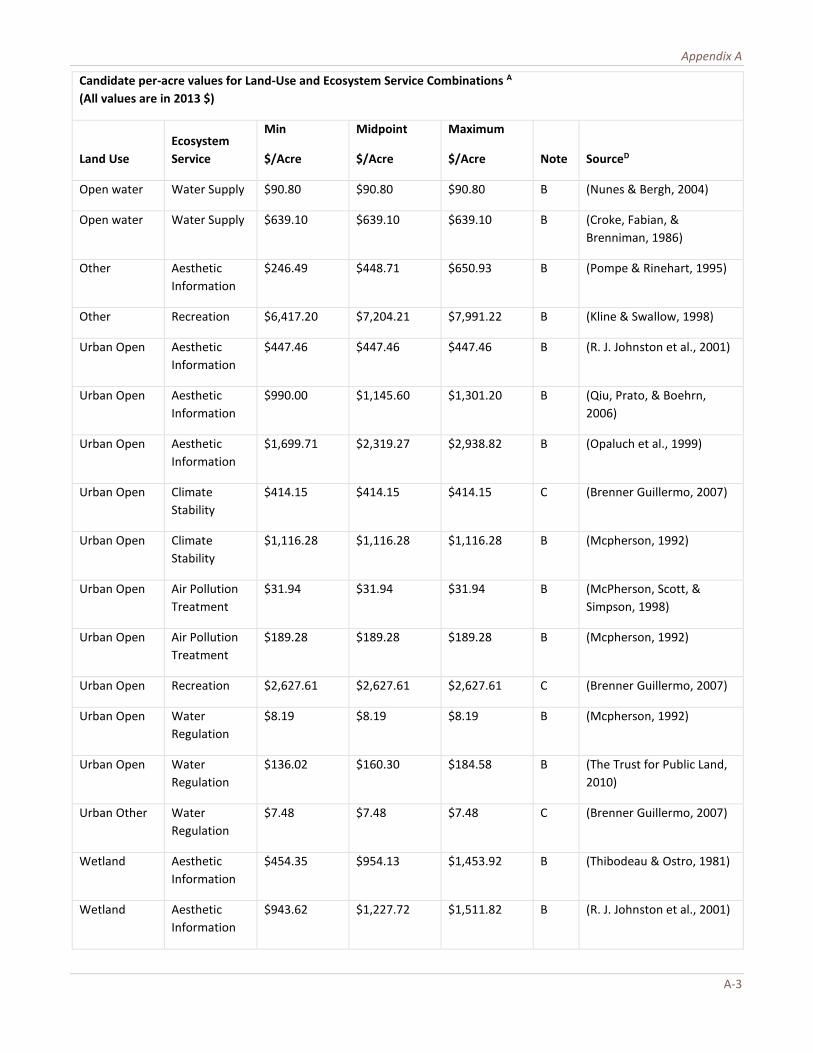
Appendix A
A-3
Candidate per-acre values for Land-Use and Ecosystem Service Combinations A
(All values are in 2013 $)
Land Use
Ecosystem
Service
Min
$/Acre
Midpoint
$/Acre
Maximum
$/Acre Note SourceD
Open water Water Supply $90.80 $90.80 $90.80 B (Nunes & Bergh, 2004)
Open water Water Supply $639.10 $639.10 $639.10 B (Croke, Fabian, &
Brenniman, 1986)
Other Aesthetic
Information
$246.49 $448.71 $650.93 B (Pompe & Rinehart, 1995)
Other Recreation $6,417.20 $7,204.21 $7,991.22 B (Kline & Swallow, 1998)
Urban Open Aesthetic
Information
$447.46 $447.46 $447.46 B (R. J. Johnston et al., 2001)
Urban Open Aesthetic
Information
$990.00 $1,145.60 $1,301.20 B (Qiu, Prato, & Boehrn,
2006)
Urban Open Aesthetic
Information
$1,699.71 $2,319.27 $2,938.82 B (Opaluch et al., 1999)
Urban Open Climate
Stability
$414.15 $414.15 $414.15 C (Brenner Guillermo, 2007)
Urban Open Climate
Stability
$1,116.28 $1,116.28 $1,116.28 B (Mcpherson, 1992)
Urban Open Air Pollution
Treatment
$31.94 $31.94 $31.94 B (McPherson, Scott, &
Simpson, 1998)
Urban Open Air Pollution
Treatment
$189.28 $189.28 $189.28 B (Mcpherson, 1992)
Urban Open Recreation $2,627.61 $2,627.61 $2,627.61 C (Brenner Guillermo, 2007)
Urban Open Water
Regulation
$8.19 $8.19 $8.19 B (Mcpherson, 1992)
Urban Open Water
Regulation
$136.02 $160.30 $184.58 B (The Trust for Public Land,
2010)
Urban Other Water
Regulation
$7.48 $7.48 $7.48 C (Brenner Guillermo, 2007)
Wetland Aesthetic
Information
$454.35 $954.13 $1,453.92 B (Thibodeau & Ostro, 1981)
Wetland Aesthetic
Information
$943.62 $1,227.72 $1,511.82 B (R. J. Johnston et al., 2001)

The Economic Benefits of Cleaning Up the Chesapeake
A-4
Candidate per-acre values for Land-Use and Ecosystem Service Combinations A
(All values are in 2013 $)
Land Use
Ecosystem
Service
Min
$/Acre
Midpoint
$/Acre
Maximum
$/Acre Note SourceD
Wetland Climate
Stability
$61.68 $2,423.38 $4,785.07 B (Flores et al., 2013)
Wetland Climate
Stability
$211.85 $211.85 $211.85 B (Hughes, 2006)
Wetland Food $5.65 $356.71 $707.76 B (Sandra S. Batie, 1978)
Wetland Food $58.93 $98.31 $137.69 B (Bell, 1989)
Wetland Food $802.40 $802.40 $802.40 B (Hughes, 2006)
Wetland Food $1,000.44 $1,000.44 $1,000.44 B (R. J. Johnston et al., 2001)
Wetland Air Pollution
Treatment
$74.29 $85.37 $96.45 B (Jenkins, Murray, Kramer,
& Faulkner, 2010)
Wetland Recreation $79.42 $79.42 $79.42 B (Bergstrom, Stoll, Titre, &
Wright, 1990)
Wetland Recreation $107.55 $265.33 $423.11 B (Robert Costanza, Farber, &
Maxwell, 1989)
Wetland Recreation $120.74 $120.74 $120.74 B (Whitehead, Groothuis,
Southwick, & Foster-Turley,
2009)
Wetland Recreation $152.75 $662.39 $1,172.02 B (Bell, 1989)
Wetland Recreation $204.69 $204.69 $204.69 B (Kreutzwiser, 1981)
Wetland Recreation $215.29 $932.29 $1,649.28 B (Raphael & Jaworski, 1979)
Wetland Recreation $417.32 $417.32 $417.32 B (G. D. Anderson &
Edwards, 1986)
Wetland Recreation $568.66 $5,382.12 $10,195.58 B (Thibodeau & Ostro, 1981)
Wetland Recreation $638.21 $2,387.46 $4,136.71 B (Whitehead, 1990)
Wetland Recreation $1,024.42 $1,024.42 $1,024.42 B (Creel & Loomis, 1992)
Wetland Waste
Treatment
$65.95 $3,138.39 $6,210.84 B (Breaux, Farber, & Day,
1995)
Wetland Waste
Treatment
$542.22 $542.22 $542.22 B (Jenkins et al., 2010)

Appendix A
A-5
Candidate per-acre values for Land-Use and Ecosystem Service Combinations A
(All values are in 2013 $)
Land Use
Ecosystem
Service
Min
$/Acre
Midpoint
$/Acre
Maximum
$/Acre Note SourceD
Wetland Waste
Treatment
$4,484.94 $4,484.94 $4,484.94 B (Thibodeau & Ostro, 1981)
Wetland Water
Regulation
$1,271.60 $1,271.60 $1,271.60 (Weber, 2007)
Wetland Water Supply $612.83 $612.83 $612.83 B (Creel & Loomis, 1992)
Wetland Water Supply $18,307.22 $18,307.22 $18,307.22 B (Thibodeau & Ostro, 1981)
Notes:
A. From this list of candidate values, two options for valuation were created: the minimum of the minimum value for all
studies for which an estimate is available for a give land use-ecosystem service pair; and the average of the midpoints
of estimates from those studies. Ultimately, and for the sake of providing conservative estimates, the minimum of the
minimum values was used for this study. Details are provide in this table to provide a sense of the range of values
available in the literature.
B. These values were obtained via contract for a custom data pull from Earth Economics Ecosystem Valuation Toolkit in
March 2014. Earth Economics selected options from thousands of studies based on applicability to the Chesapeake Bay
Watershed. http://esvaluation.org/.
C. Values selected from the TEEB (The Economics of Ecosystems and Biodiversity) Valuation Database (Van der Ploeg et
al., 2010).
D. Full references are included under “Works Cited,” above.

APPENDIX B: BENEFIT VALUES FOR CHESAPEAKE BAY JURISDICTIONS BY ECOSYSTEM SERVICE AND LAND TYPE 8
8 Grand totals for the three scenarios may differ slightly from Tables 5-7 due to rounding.
Baseline Scenario (2013 $ in millions) Ecosystem Service DC DE MD NY PA VA WV
Aesthetic Information
8,250
179,692
6,170,885
3,535,903
11,037,658
15,314,725
2,198,665
Climate Stability
1,670
35,267
483,557
628,258
1,966,361
1,997,954
385,460
Food
0.03
235,911
1,741,515
1,265,001
4,130,274
4,036,635
719,582
Air Pollution Treatment
0.36
19,690
289,646
400,634
1,242,712
1,266,390
251,829
Recreation
8,040
55,476
605,087
255,730
964,192
1,082,933
99,523
Waste Treatment
4,756
28,250
3,772,701
563,327
1,797,949
5,651,129
337,322
Water Regulation
1,091
70,108
1,097,459
1,419,439
4,394,382
4,511,545
892,300
Water Supply
1,615
110,768
1,731,435
2,292,901
7,103,755
7,333,201
1,445,164
Total
25,422
735,162
15,892,285
10,361,193
32,637,283
41,194,512
6,329,845
Blueprint Scenario (2013 $ in millions) Ecosystem Services DC DE MD NY PA VA WV
Aesthetic Information 10,110 247,430 8,272,339 4,268,957 13,057,363 18,932,293 2,618,193
Climate Stability 1,940 50,753 566,830 759,832 2,338,966 2,325,674 464,454
Food 0.03 238,828 1,824,795 1,285,065 5,003,963 4,014,719 945,160
Air Pollution Treatment 0.54 27,348 332,845 484,297 1,468,013 1,448,296 299,206
Recreation 7,312 89,211 760,207 311,660 1,258,110 1,504,861 167,488
Waste Treatment 5,245 37,470 5,438,331 679,075 2,130,704 7,778,194 401,397
Water Regulation 1,813 96,929 1,246,646 1,715,802 5,187,391 5,141,342 1,058,259
Water Supply 2,764 152,937 2,007,026 2,771,498 8,383,866 8,394,762 1,713,818
Total 29,185 940,906 20,449,019 12,276,186 38,828,376 49,540,141 7,667,975
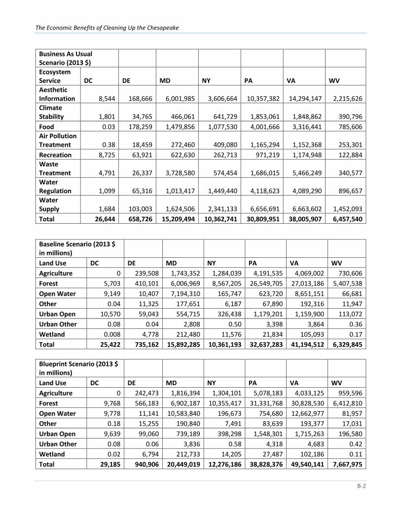
The Economic Benefits of Cleaning Up the Chesapeake
B-2
Baseline Scenario (2013 $ in millions) Land Use DC DE MD NY PA VA WV
Agriculture 0 239,508 1,743,352 1,284,039 4,191,535 4,069,002 730,606
Forest 5,703 410,101 6,006,969 8,567,205 26,549,705 27,013,186 5,407,538
Open Water 9,149 10,407 7,194,310 165,747 623,720 8,651,151 66,681
Other 0.04 11,325 177,651 6,187 67,890 192,316 11,947
Urban Open 10,570 59,043 554,715 326,438 1,179,201 1,159,900 113,072
Urban Other 0.08 0.04 2,808 0.50 3,398 3,864 0.36
Wetland 0.008 4,778 212,480 11,576 21,834 105,093 0.17
Total 25,422 735,162 15,892,285 10,361,193 32,637,283 41,194,512 6,329,845
Blueprint Scenario (2013 $ in millions) Land Use DC DE MD NY PA VA WV
Agriculture 0 242,473 1,816,394 1,304,101 5,078,183 4,033,125 959,596
Forest 9,768 566,183 6,902,187 10,355,417 31,331,768 30,828,530 6,412,810
Open Water 9,778 11,141 10,583,840 196,673 754,680 12,662,977 81,957
Other 0.18 15,255 190,840 7,491 83,639 193,377 17,031
Urban Open 9,639 99,060 739,189 398,298 1,548,301 1,715,263 196,580
Urban Other 0.08 0.06 3,836 0.58 4,318 4,683 0.42
Wetland 0.02 6,794 212,733 14,205 27,487 102,186 0.11
Total 29,185 940,906 20,449,019 12,276,186 38,828,376 49,540,141 7,667,975
Business As Usual Scenario (2013 $) Ecosystem Service DC DE MD NY PA VA WV
Aesthetic Information 8,544 168,666 6,001,985 3,606,664 10,357,382 14,294,147 2,215,626
Climate Stability 1,801 34,765 466,061 641,729 1,853,061 1,848,862 390,796
Food 0.03 178,259 1,479,856 1,077,530 4,001,666 3,316,441 785,606
Air Pollution Treatment 0.38 18,459 272,460 409,080 1,165,294 1,152,368 253,301
Recreation 8,725 63,921 622,630 262,713 971,219 1,174,948 122,884
Waste Treatment 4,791 26,337 3,728,580 574,454 1,686,015 5,466,249 340,577
Water Regulation 1,099 65,316 1,013,417 1,449,440 4,118,623 4,089,290 896,657
Water Supply 1,684 103,003 1,624,506 2,341,133 6,656,691 6,663,602 1,452,093
Total 26,644 658,726 15,209,494 10,362,741 30,809,951 38,005,907 6,457,540

Appendix B
B-3
Business as Usual Scenario (2013 $) Land Use DC DE MD NY PA VA WV
Agriculture 0 180,973 1,477,960 1,093,631 4,061,077 3,338,129 797,478
Forest 5,978 381,142 5,657,415 8,747,204 24,877,652 24,536,470 5,433,512
Open Water 9,191 9,830 7,146,112 167,680 587,098 8,558,438 70,550
Other 0.04 10,334 146,250 6,417 64,571 145,578 12,656
Urban Open 11,475 71,768 621,842 335,563 1,194,488 1,348,171 143,343
Urban Other 0.10 0.04 3,302 0.49 3,366 4,120 0.43
Wetland 0 4,679 156,613 12,246 21,699 75,001 0.070
Total 26,644 658,726 15,209,494 10,362,741 30,809,951 38,005,907 6,457,540


The report, commissioned by the Chesapeake Bay Foundation, was developed by Spencer Phillips, Ph.D., with scientific assistance from Beth McGee, Ph.D., and peer reviewed by Dr. Gerald Kaufman of University of Delaware, Dr. Valerie Esposito of Champlain College, Dr. Tania Briceno of Earth Economics, and Mr. Dan Nees of the University of Maryland.
Dr. Spencer Phillips is a natural resource economist with more than 20 years of experience researching the relationships between ecosystems and economic well-being. Currently the Principal of Key-Log Economics, LLC, based in Charlottesville, Virginia, he has been an economist at the White House Council on Environmental Quality, Senior Economist and Vice President for Ecology and Economics Research at The Wilderness Society, and Executive Director of the Northwoods Stewardship Center. Phillips received his doctorate from Virginia Polytechnic Institute and State University and his B.A. from the University of Virginia. He lectures at The University of Virginia and Goucher College in microeconomics, ecological economics, and public policy.
Dr. Beth McGee is the Senior Water Quality Scientist at the Chesapeake Bay Foundation, where she has worked since 2003. She has a B.A. in Biology from the University of Virginia, a M.S. in Ecology from the University of Delaware, and a Ph.D. in Environmental Science from the University of Maryland. She has more than 20 years of experience in Chesapeake Bay water-quality issues, published numerous peer-reviewed papers, and served on multiple technical committees and advisory groups. Prior to CBF, she worked for the U.S. Fish and Wildlife Service, U.S. Environmental Protection Agency, and the Maryland Department of the Environment.
MarylandPhilip Merrill Environmental Center6 Herndon AvenueAnnapolis, MD 21403410/268-8816
Eastern Shore102 East Dover StreetEaston, MD 21601410/543-1999
VirginiaCapitol Place1108 East Main StreetSuite 1600Richmond, VA 23219804/780-1392
Hampton Roads142 West York StreetSuite 618Norfolk, VA 23510757/622-1964
Pennsylvania1426 North Third Street, Suite 220Harrisburg, PA 17102717/234-5550
Washington, D.C.1615 M Street, NWWashington, DC 20036202/544-2232
cbf.org
October 2014