the environmental, economic and social condition …...in the nam ngum river basin’ (scheufele,...
TRANSCRIPT

THE ENVIRONMENTAL, ECONOMIC AND
SOCIAL CONDITION OF THE
NAM MOUANE – NAM GNOUANG CATCHMENT
Research Report No. 5
October 2014
Xiong Tsechalicha1, Yiakhang Pangxang2, Saysamone Phoyduangsy3 & Phouphet
Kyophilavong4
The project ‘Effective Implementation of Payments for Environmental Services in Lao PDR’ is funded by the Australian Centre for
International Agricultural Research (ACIAR). The reports produced within this project are published by the Crawford School of
Public Policy, Australian National University, Canberra, 0200 Australia.
The reports present work in progress being undertaken by the project team. The views and interpretations expressed in these reports
are those of the author(s) and should not be attributed to any organization associated with the project. Because these reports present
the results of work in progress, they should not be reproduced in part or in whole without the authorization of the Australian Project
Leader, Professor Jeff Bennett ([email protected]).
1Centre for Environmental Economics & Policy, University of Western Australia 2,3,4Faculty of Economics and Business Management, National University of Laos
Effective Implementation of
Payments for Environmental Services
in Lao PDR
Research Reports
ISSN 2202-7432

Page |
2
Abstract
The main objective of this Research Report is to overview the environmental, economic
and social condition of the Nam Mouane – Nam Gnouang catchment. This Research
Report identifies threats to forest wildlife and forest cover arising from current
management practices and suggests possible management actions to achieve
environmental improvements. These include reducing the expansion of shifting
cultivation into undisturbed forests by improving agricultural productivity of slash-and-
burned; reducing poaching/ hunting of forest wildlife through increased patrolling and the
collection of snares.
Keywords: Nam Mouane -Nam Gnouang catchment, environmental threats, management
actions, payments for environmental services

Page |
3
Table of Contents
Acronyms ............................................................................................................................ 4
1. Introduction .............................................................................................................. 5
2. Overview .................................................................................................................. 5
3. Agriculture .............................................................................................................. 10
4. Forestry ................................................................................................................... 13
5. Other land uses ....................................................................................................... 22
6. Administration ........................................................................................................ 26
7. Population ............................................................................................................... 27
8. Land tenure ............................................................................................................. 30
9. Threats to the environment ..................................................................................... 30
10. Existing management strategies and actions .......................................................... 35
11. Possible new management actions ......................................................................... 37
12. Conclusion .............................................................................................................. 38
Acknowledgments ............................................................................................................. 39
Annex: Village Land Use Maps ........................................................................................ 40

Page |
4
Acronyms
CCN Community Conservation Network
DoF Department of Forestry
EPF Environment Protection Fund
GoL Government of Lao PDR
NAFRI National Agriculture and Forestry Research Institute
NG Nam Gnouang (river)
NMNG Nam Mouane-Nam Gnouang (catchment)
NPA National Protected Area
NTFP Non-Timber Forest Product
PES Payment for Environmental Services
PONRE Provincial Department of Natural Resources and Environment
(Bolikhamxay)
PPA Provincial Protected Area
THPC Theun-Hinboun Power Company
THPP Theun-Hinboun Power Project
THXP Theun-Hinboun Expansion Project
WCS Wildlife Conservation Society

Page |
5
1. Introduction
This Research Reportprovides a baseline for the development of a bio-physical model of
alternative environmental management options in the Nam Mouane-Nam Gnouang1
(NMNG) catchment in the Bolikhamxay Province, Lao People’s Democratic Republic
(Lao PDR). The bio-physical model will be one element of a Payment for Environmental
Services (PES) scheme designed as a pilot in the Lao PDR context. Detailed information
on how a PES scheme would be designed, implemented and assessed step-by-step in the
Lao context is presented in Research Report 3 ‘Development of a “virtual” PES scheme
in the Nam Ngum River Basin’ (Scheufele, Bennett, Kragt, & Renten, 2014), which
establishes a draft set of guidelines for PES design, operation and assessment.
RR5 provides an overview of the biophysical environmental, economic and social
conditions of the NMNG catchment and, in more detail, of the area to be involved in the
pilot PES scheme. It provides information on the resource endowment, land use,
administration, socio-economic situation and land tenure. Based on this information, RR5
identifies threats to the provision of environmental services and suggests possible
management actions to achieve environmental improvements and/ or prevent
environmental deterioration.
2. Overview
The NMNG catchment is located in the Bolikhamxay Province and extends over an area
of about 524,406 hectares (Provincial Department of Natural Resources and Environment
of Bolikhamxay, 2014). It encompasses the districts of Khamkeut, Xaychamphone and
Viengthong (see Figure 1). The NMNG is rich in natural resources providing a variety of
environmental services such as supply of biodiversity, provision of recreational and
tourist opportunities, flood protection and soil erosion control. These environmental
1Also spelled Ngouang.

Page |
6
services contribute to the socio-economic development of the Bolikhamxay Province and
the Lao PDR as a whole.
Topographically the area is predominately mountainous interspersed with karst
landscapes. The elevation ranges from about 140 meters on the Mekong flood plain up to
2,300 meters along the Annamite Mountain Range bordering on Vietnam (Norplan A.S.,
2008b). Especially the upper catchment is characterized by a lack of flat land traditionally
used for rice paddy cultivation.
The NMNG catchment consists of two major river systems - the Nam Mouane and Nam
Gnouang- and numerous streams. The Nam Mouane originates in the highlands of the
northern region of Viengthong District with a catchment area of 236,868 hectares. The
Nam Gnouang2 originates in the Annamite mountain range with a catchment area of
about 287,538 hectares (Provincial Department of Natural Resources and Environment of
Bolikhamxay, 2014). Both rivers drain into the Nam Kading3, which eventually
confluents with the Mekong River.
2 In fact the headwater of this river composes of two smaller rivers named the Nam Heuang and Nam Chat. 3 The downstream section of the Nam Theun is called Nam Kading.
Villages of PES target
Nam Kading NPA
NMNG National Protection Forest
NG Reservoir
Lower NG Protection Forest
Reforestation Area
District Boundaries
LEGEND
Viengthong District
Xaychamphone District
Khamkeut District

Page |
7
Figure 1: Location of PES target villages within the NMNG catchment area
Source: Bolikhamxay PONRE
One of the main features of the catchment is the Nam Gnouang reservoir. For the purpose
and focus of this research the NMNG catchment is divided into an ‘upper’ and a ‘lower’
catchment (Figure 1). The dark green shaded area encompassing the reservoir is the lower
catchment. The rest – north of the reservoir - makes up the ‘upper’ catchment. The Nam
Gnouang reservoir was built in 2012 by damming the Nam Gnouang. At its full supply
level the reservoir covers about 105 square kilometers, extending about 100 kilometers
upstream (Social and Environmental Division, 2011). The Theun-Hinboun Power
Company (THPC) undertook this development with the aim of increasing and
maintaining a stable power generation capacity, especially during the dry season. This is
achieved by diverting additional water from the Nam Gnouang - Nam Theun catchment
into the Nam Hai - Hinboun catchment where the powerhouse is located. The Theun-
Hinboun Expansion Project headpond is located at an elevation of 400 meters above
mean sea level with the powerhouse being at 170 meters above mean sea level (Norplan
A.S., 2008b).
The mountainous topography influences air temperature and rainfall within the NMNG
catchment (Tables2). The average maximum temperature (measured from 1990 to 2013)
ranges from 28.5°C in December/ January to 34.1°C in April. The average minimum
temperature (measured from 1990 to 2013) ranges from 16.19°C in December to 25.68°C
in June. The average monthly rainfall (measured from 1982 to 2013) ranges from 4.6mm
in December to 712.8 mm in July. The average total annual rainfall for the period is 3,191
mm. Figure 4 below shows the relative monthly humidity averaged for the period 1990 to
2013.
The NMNG catchment holds deposits of gold, lead, graphite. Some small-scale
commercial mining is currently taking place (Souriya & Pangkham, 2014)4. Additionally,
villagers, mainly from Kengbit village, get involved in alluvial panning for gold at the
Nam Gnouang and Nam Kading before the start of the wet season, taking advantage of
low water levels (Norplan A.S., 2008b).
4 One mining company operating in the catchment is the Phonesack Mining Company.

Page |
8
Figure 2: Average minimum and maximum temperature 1990-2013 (˚C), Pakxan Weather
Station
Source: Bolikhamxay PONRE, Division of Meteorology and Hydrology, 2014.
Figure 3: Average Monthly Rainfall 1984-2013 (mm), Pakxan Hydromet Station
Source: Bolikhamxay PONRE, Division of Meteorology and Hydrology, 2014
16.1918.13
21.1223.57 24.27 25.68 24.78 24.3 23.43 22.22
19.7317.25
28.5630.25
32.334.15 32.59 30.92 30.47 29.92 30.77 30.95
29.9828.15
0
10
20
30
40
50
60
70
Jan Feb Mar Apr May Jun Jul Aug Sep Oct Nov Dec
Avg Max
Avg Min
0
100
200
300
400
500
600
700
800
Jan Feb Mar Apr May Jun Jul Aug Sep Oct Nov Dec

Page |
9
Figure 4: Average relative monthly maximum and minimum humidity, 1990-2013 (%)
Source: Bolikhamxay PONRE, Division of Meteorology and Hydrology, 2014
Figure 5: Average evaporation 2000-2013 (mm)
Source: Bolikhamxay PONRE, Division of Meteorology and Hydrology, 2014.
The area to be involved in the PES scheme consists of land allocated to nine villages with
a total land area of 100,631 hectares in three districts as follows5:
- Khamkeut District (Hang Na Village; Lak 5 Village; Na Heuang Village),
- Xaychamphone District (Nam On Village; Phon Kham Village; Vangban Village),
and,
5 Maps of the village land use are provided in the Annex.
0
20
40
60
80
100
120
Jan Feb Mar Apr May Jun Jul Aug Sep Oct Nov Dec
Max
Min
4.584.84
5.185.65
4.94
4.393.91
3.57
4.8 4.92 4.844.37
0
1
2
3
4
5
6
Jan Feb Mar Apr May June Jul Aug Sep Oct Nov Dec

Page |
10
- Viengthong District (Na Tan Village; Na Yang Village; Pha Bo Village).
These villages are located within the NMNG National Protection Forest.Pha Bo Village is
located immediate to the edge of the Phou Sithon Endangered Species Conservation
Area; Vangban Village is located inside the Nam Chat/Nam Pan PPA while Nam On and
Phon Kham Villages are located close to its boundaries. The three PES pilot villages of
Khamkeut District are located in proximity to the Phou Chomvoy Provincial Protected
Area (PPA) that covers an area of 25,040 hectares (Travers, Clements, & Hedemark,
2010), adjoining the area to the east. The livelihoods of all villages are based on
subsistence agriculture, but the economic, social and environmental conditions of the
areas in which they are located vary across the three districts. For example, the three
villages in Khamkeut District are better connected to infrastructure and have higher
education levels than the villages in the Xaychamphone and Viengthong Districts.
3. Agriculture
The main crops cultivated in the NMNG catchment are rice, maize, cassava, peanut and
taro (Pangxang, Phoyduangsy, & Tsechalicha, 2014; Souriya & Pangkham, 2014). The
use of chemical fertilizers, pesticides and herbicides has become popular among farmer
groups to increase agricultural productivity. As a consequence, water resources are
increasingly polluted with chemicals causing problems such as fish kill (Pangkham,
2014).
Farmers in the NMNG catchment mainly grow upland rice since flat areas required for
paddy cultivation are limited. The yield of traditional upland rice farming is, in general,
lower than the yield of the lowland paddy rice production6. Thus, many farmers
frequently experience a shortage in rice supply. As a result, farmers supplement their
food supply through the harvest of non-timber forest products (NTFP) from their
surrounding environment for sale to buy rice. Farmers in most villages expand their
6 Based on the provincial figures of rice production area and yield for the 2010-11 production season, the
average upland rice yield of Bolikhamxay Province is estimated to be 1.7 tons/ha versus 3.7 tons/ha of
lowland paddy yield (Department of Planning and Investment in Bolikhamxay, 2012).

Page |
11
agricultural land within a respective village land use area every year. In general, the area
used for shifting cultivation through slash and burn is expanding, on average, one hectare
per family per year (Souriya & Pangkham, 2014). For example, in the three target PES
villages of the Khamkeut District(Lak 5 Village, Hang Na and Na Heuang)the percentage
of households that have sufficient rice paddy land to produce sufficient rice for their own
consumption is 80%, 95% and 79%,respectively. In these villages dependency on slash
and burn farming is generally low even though the size of slash and burn fields in Lak 5
and Hang Na is estimated at five hectares and two hectares per household, respectively
(Pangxang et al., 2014). Nevertheless these slash and burn fields are not located in old
growth forest, rather they are cleared in fallow areas adjacent to the paddy fields. As for
the six other PES villages7 in Viengthong and Xaychamphone Districts, slash and burn
fields are cleared within the protection forest (Provincial Department of Natural
Resources and Environment of Bolikhamxay, 2014). Based on local information
regarding land use for upland agriculture of approximately one hectare per family each
season (Norplan A.S., 2008a) has put an estimate of the land use ‘in any one rotation of
crops’ at 736 ha in the NG area. However given that not all households of the nine
villages to be involved in the PES scheme in the NMNG catchment would expand their
agricultural land, this estimate may be a crude indication of agricultural land expansion in
the area in any cropping season and may not be generalized for the 758 households under
the PES pilot scheme.
The areas that are currently used for agriculture are effectively bereft of vegetation aside
from whatever crop that is planted there. The continuous expansion of shifting cultivation
into undisturbed forests destroys and fragments habitats, reducing biodiversity levels.
Shifting cultivation has been practiced for many years in the NMNG catchment. Due to
varying fallow periods (3-10 years) the disturbed landscape is a mixture of re-growth at
various stages (Norplan A.S., 2008a). As the report states,
‘… areas that have been fallow for1-3 years are dominated by grasses and
herbaceous perennial plants such as Erianthus arundinaceus, Ageratum
conyzoides, Eupatorium odoratum, Themeda triandra, and Imperata Cylindrica.
In areas that have been in fallow for approximately 3-6 years it is evident that
7Pha Bo villagers reported that they only practice slash and burn on Imperata cylindrica grassland.

Page |
12
pioneer tree species have begun to regenerate and previously dominant grasses
and herbaceous plants have declined. In areas that had been fallow for 8-10 years
trees have started to form an open canopy, although bamboo species are
prominent.’(Ibid)
Some areas that have not been used for shifting cultivation for decades, such as the area
North of the Nam Khamang (close to the Nam Gnouang reservoir), have been affected by
uncontrolled fires in adjacent areas that have repeatedly scorched vast hillsides (Norplan
A.S., 2008a). As a result, tree species have been unable to gain a foothold, instead grasses
and herbaceous perennial species dominate the land (Ibid.).
Gardening by local people is a common livelihood activity. For instance, about 20
households out of 123 households in Lak 5 Village do gardening on an average of one
rai8 of land per household. Almost every household in Hang Na Village does gardening,
although the production of the latter is still mainly for household consumption(Pangxang
et al., 2014).
Industrial plantations (e.g., rubber) are limited in the NMNG catchment except for some
cultivation of cassava and maize as cash crops for sale to buyers in Vietnam (Souriya &
Pangkham, 2014). The prices given for these crops in Lak 5 Village are 1300 Kip/kg and
2000 Kip/kg respectively; in Hang Na Village these are1100 Kip/kg and 1500 Kip/kg
respectively (Pangxang et al., 2014). The two villages experience shortages of rice supply
for four and three months respectively, during which time they secure their supply of rice
by selling cassava, maize, as well as livestock. Overall, these villages rely fully on
agriculture for their income, including on non-rice crops. Pha Bo villagers in Viengthong
District, on the other hand, grow crops such as vegetables, taro, sweet potato, cucumber
and cabbage, among others, on the upland fields. This produce is mainly for self-
consumption, and only a little is sold to the market at the district administrative town.
Hence the principal income source of the village is from the sale of livestock, mainly
cattle and buffaloes. The main problem faced by the village is a shortage of water supply,
especially during the dry season. While the Phou Thai and Tai Daeng living in Lak 5
Village have had enough rice paddy land, the Hmong did not have paddy land until a few
years ago. Yet they have recently acquired rice paddy land In contrast, the Hmong in Pha
8 A surface measurement unit, 1 rai = 1,600 m2.

Page |
13
Bo do not have any paddy land9 (given the village’s high altitude) and have been
practicing slash-and-burn cultivation on fallow areas near the village. However their
principle livelihood activity is animal husbandry, mainly cattle, on the grassland
surrounding their village.
4. Forestry
Forest Cover
The level of forest cover for Bolikhamxay Province was estimated at 54.9% in 2010
compared to 61.4% in 2002. The reduction in forest cover was attributed to forestland
conversion for agriculture and industrial plantation (Department of Forestry, 2012). The
upper NMNG catchment is covered predominately with secondary growth as the land has
been used extensively for shifting cultivation for at least three generations (Social and
Environmental Division, 2011). The remaining original forests are generally concentrated
in the mountainous area along the Lao-Vietnam border region. Areas of original forest
cover of mixed deciduous forest are found along streams and on hillsides while patches
of Evergreen Forest persist in gullies at higher elevations where stands of deciduous
forest and bamboo are found (Norplan A.S., 2008a). Tizard (1996) reports that all areas
along the Nam Gnouang are heavily utilized by humans and only the higher peaks and
ridge tops still retain forest with Evergreen Forest only remains in ‘five widely separated
patches’ on the larger hills and mountains in the area. By the team’s observation in
Viengthong and Khamkeut Districts, remnant of some undisturbed forests exists along
mountain ridges, on karsts and on steep slopes. However, since no surveys have been
conducted on the undisturbed forest areas in the NMNG catchment, there are no data
available on the extent of undisturbed forests.
Forest cover of the whole Lao PDR is shown in figure 6 below, with area targeted for
PES scheme indicated. According to Norplan A.S. (2008a), ‘areas close to the villages
9This can partly be explained by the fact that many Hmong families live in the lowland where their paddy
lands are located; their presence in Pha Bo is mainly for raising livestock chiefly cattle.

Page |
14
that are located along the Nam Gnouang could be regarded as unstocked forest10 or
upland re-growth.’ The report notes further that ‘these are previously forested areas
where crown density has been reduced to less than 20% (or in some cases 0%) as a result
of heavy disturbance through shifting cultivation practices’. This has led to a loss of
forest structure, a disturbance of ecological processes and a decline in biodiversity.
Figure 6: Forest Cover of Lao PDR in 2010
Source: Department of Forestry (2012), English legends added.
10Unstocked forest areas are defined as ‘previously forested areas in which the crown density has been
reduced to less than 20% because of logging, shifting cultivation or other heavy disturbance. If the area is
left to grow undisturbed it becomes forest again’(Department of Forestry, 2012).
Actual forest area
Non-forest area

Page |
15
Biodiversity
While information on wildlife in the Nam Mouane sub-catchment is relatively
scarce/inaccessible, the Nam Gnouang sub-catchment is home to a great diversity of
wildlife species (International Centre for Environmental Management, 2010)11, including
the relatively recent discovered new species of mammals such as the Large-antlered
Muntjac (Muntiacus vuguangensis), a distinctive species of rabbit – the Annamite Striped
Rabbit (Nesolagus timminsi) (Tizard, 1996)12 and the iconic Saola (Pseudoryx
nghetinhensis). According to a preliminary survey by Tizard (1996) in the Northern
Extension area of the Nakai-Nam Theun NPA, presently the Nam Pan/Nam Chat
Provincial Protected Area which is within the NG catchment, twenty-four Key Species of
bird, as well as an additional four Key Species in the Nam Gnouang Area (NGA) of
Globally Threatened or Near Threatened birds have been documented. These include:
Crested Argus (Rheinartia ocellata), Yellow-vented Pigeon (Treron seimundii), Gray
Laughingthrush (Garrulax maesi), and Short-tailed Scimitar Babbler (Jabouillei
adanjoui). Two additional Key Species, the Malayan Night-Heron (Gorsachius
melanolophus) and the Blyth’s Kingfisher (Alcedo hercules) have been found. Mammals
include, in addition to the Saola, Rhesus Macaque (Macaca mulatta), Stump-tailed
Macaque (Macaca arctoides), Douc Langur (Pygathrix nemaeus), Gibbon sp., Black
Giant Squirrel (Ratufa bicolor), Muntjac sp., Southern Serow (Naemorhedus
sumatraensis) among other birds and mammals. However, no recorded information on
plant diversity is available in the NMMG catchment but logging of valuable tree species
is also reported (see Section on Forest Use). Table 1 presents the key wildlife species of
conservation concern in the Nam Gnouang catchment.
11
Tizard (1996) surveys in the area suggests however that these areas seem to support a lower density of
many mammals found elsewhere in Lao especially primates, Ratufa squirrels and large mammals (i.e. big
cats, bears, wild cattle, etc.). 12Tizard (1996) reports on the two species of wildlife as unnamed then. Names are added by verifying the
information in Duckworth et al. (1999) and IUCN Red List data - see http://www.iucnredlist.org.

Page |
16
Table 1: Key wildlife species of conservation concern in the Nam Gnouang catchment
Species Conservation status
Birds
Crested Argus (Rheinardia ocellata) At Risk in Lao PDR*
Crested Kingfisher (Megaceryle lugubris) Regionally At Risk
Great Hornbill (Buceros bicornis) At Risk in Lao PDR*
River Lapwing (Vanellus duvaucelii) National Long-term Decline
Large-billed Crow (Corvus macrorhynchos) Unknown?
Mammals
Macaques Regionally At Risk
Douc Langur (Pygathrix namaeus) At Risk in Lao PDR*
Phayre'sLangur (Semnopithecus phayrei) At Risk in Lao PDR*
Gibbons At Risk in Lao PDR*
Bears At Risk in Lao PDR*
Otters Regionally At Risk /Globally Threatened
Asian Golden Cat (Catopuma temminckii) Globally Near-Threatened; Little Known
in Lao PDR*
Tiger (Panthera tigris) At Risk in Lao PDR*
Asian Elephant (Elephas maximus) Globally Threatened
Heude’s Pig (Sus bucculentus) Little Known in Lao PDR*
Saola (Pseudoryx nghetinhensis) Critically Endangered**
Muntjac sp. Depending on species: Little Known or
Potentially At Risk in Lao PDR*
Sambar (Cervus unicolor) Potentially At Risk in Lao PDR*
Gaur (Bos gaurus) Globally Threatened; At Risk in Lao PDR*
Banteng (Bos javanicus) At Risk in Lao PDR*
Serow(Naemorhedus sumatraensis) At Risk in Lao PDR*
Black Giant Squirrel (Ratufa bicolor) Potentially At Risk in Lao PDR*
Source: Adapted from (International Centre for Environmental Management, 2010) based on (W.
Robichaud, 2003) and (Wildlife Conservation Society, 2007) surveys. *Based on Duckworth et al (1999);
**Assessed as ‘At Risk in Lao PDR’ by Duckworth et al (Duckworth et al., 1999).

Page |
17
Discovered in 1992 by science, the Saola is classified as Critically Endangered on the
IUCN Red List. It is a flagship species occurring only in Lao PDR and Vietnam along
this section of the Annamite Mountain Range, which is considered its main habitat
(Tizard, 1996)13. Saola is the key species to protect in the Bolikhamxay Province
(Integrated Ecosystem and Wildlife Management Project, 2006), given its undetermined
small population and limited habitat range in the area as well as threats it faces. Other
wildlife species present in the NMNG catchment area which are of potential focus for the
PES pilot scheme are Large-antlered Muntjac (Muntiacus vuquangensis) and White-
cheeked Gibbon (Hylobates leucogenys) (Vongkhamheng, 2014), listed by the IUCN Red
List as Endangered and Critically Endangered, respectively. Both animals, whose status
is Potentially at Risk in Lao PDR, are listed as Lao PDR Category I Protected Species.
Additionally other large bird species may be suitable for potential monitoring, especially
as forest protection and reduced hunting through patrolling may logically result in species
population increase.
Forest categories
Almost the entire upper NMNG catchment (524,406 ha) is broadly categorised as
National Protection Forest (Provincial Department of Natural Resources and
Environment of Bolikhamxay, 2014). In addition, Bolikhamxay Province has established
the Nam Gnouang South Protected Forest Area14 covering over 50 square kilometres,
whose management is being supported by the Wildlife Conservation Society (WCS). The
area includes much of the former village shifting cultivation areas that are no longer used
in the catchment area(Social and Environmental Division, 2012).
13Saolas are confined to a small range in the Annamite Mountains of central Laos and Vietnam. Saolas are not
known to occur in large numbers outside of the Northern Extension, presently the Nam Pan/Nam Chat
Provincial Conservation Forest, or the Nam Gnouang Area (Tizard, 1996). 14 It is unclear whether Conservation Forest Areas have the status of a National Protected Area, Provincial
Protected Area or District Protected Areas.

Page |
18
The villages in the NMNG catchment also have reforestation, production, conservation,
and protection forests allocated15 in varying degrees; logging and timber harvesting is
prohibited in reforestation and conservation forests and most likely in protection forest.
The extent of these forests in the three PES target scheme villages of Khamkeut District
and one village in Viengthong District is provided in Table 2.
Table 2: Extent of village level forest categories, Khamkeut District
Village Reforestation
forest, ha
Production
forest, ha
Conservation
forest, ha
Protection
forest, ha
Agriculture
land, ha
Plantation
land, ha
Lak 5 380.7 300.8 40 265.87 Hang Na 40 (79.3) 10 (241.9) 100 (382.8) 30 231 32 (12 ha
planted) Na Heuang - 201 896 - 348 -
Pha Bo 12,369 4,355 1,042.75
Source:(Pangxang et al., 2014). Numbers in brackets columns 2-4 for Hang Na are based on information
provided by Bolikhamxay PONRE (2014).
Protected Areas
The forest in the Bolikhamxay Province is of significant environmental value. The
National Protected Areas are shown in Figure 7. The province contains the NamKading
National Protected Area (NPA) with an area of 169,000 hectares (Southammakoth, 1999)
located to the southwest of the NMNG catchment. To the southeast of the NMNG
catchment, the Nakai-Nam Theun NPA stretches across the Bolikhamxay and
Khammouane Provinces. The Khammouane Province additionally contains the Phou Hin
Poun, also known as Khammouane Limestone, NPA. The Nakai-Nam Theun – Phou Hin
Poun Corridor links the Nakai-Nam Theun NPA with the Phou Hin Poun NPA.
The upper NMNG catchment contains the Pha Kouan Chan Provincial Protected Area
(PPA)16, the Nam Chat/Nam Pan Provincial Conservation Forest of 650 Km217 (W.
15Practically these allocated forest areas are found/ embedded inside the designated national protection
forest area, which effectively means that there is a degree of overlap between village land use allocation
and national protection forest area. 16
According to the Forestry Law 06/ NA 2007 (under review) National, Provincial and District Protected
Areas are comprised of conservation forests. Yet, almost the entire NMNG catchment is categorized
Protection Forest. The land demarcation seems to be overlapping. 17 Norplan A.S. (2008a) puts this area figure at 45,000 ha.

Page |
19
Robichaud, 2003) and Nam Chouan Provincial Conservation Forest located at the border
to Vietnam. These two Provincial Conservation Forest areas are of high biodiversity
importance and have been suggested to be considered first if a decision is to be made to
add areas to the NPA system (W. Robichaud, Marsh, Southammakoth, &
Khounthikoummane, 2001). Table3 lists the protected area network encompassing the
NMNG catchment and the surrounding region.
The NMNG catchment additionally contains two provincial endangered species
conservation areas, PhouSithon and Phou Chomvoy. These areas have been designated
for the protection of endangered species, primarily the Saola (Pseudoryx nghetinhensis)
(Souriya & Pangkham, 2014).
Figure 7: Location of National Protected Areas of Lao PDR in 2010
Source: Department of Forestry

Page |
20
Table 3: Protected areas in the Bolikhamxay Province and surrounding areas
NPA and local level PA* Area, ha Location
Nakai-Nam Theun NPA 353,200 Bolikhamxay, Khammouane Provinces
Phou HinPoun or Khammouane NPA 150, 000 Khammouane Provinceof the southern and eastern catchment of Nam Hinboun, to the south of the existing Theun Hinboun Power Station
Nam Kading NPA 169,000 Nam Kading valley downstream of the existing Theun Hinboun dam, Bolikhamxay Province
The Nam Chat/Nam Pan Provincial Conservation Forest (northeast of the Phou Chomvoy PPA)
65,000 [45,000]
Bolikhamxay Province, east of the NMNG catchment bordering Viet Nam consists mostly of undisturbed forest and habitat for rare and highly endangered wildlife species such as the Saola (Pseudoryx nghetinhensis).
Pha Kouan Chan Provincial Protected Area (PPA)
Small area Bolikhamxay Province covering most of the inaccessible limestone ridge separating the Nam Gnouang reservoir area and the Nam Theun catchment. The key species include the recently described Lao rock rat or kha-nyou (Laonastes aenigmamus), new to science.
Nakai-Nam Theun – Phou Hin Poun Corridor **
73,860 Bolikhamxay, Khammouane Provinces, forest corridor linking the Nakai-Nam Theun NPA with the Phou Hin Poun NPA, which covers the forests on each side of Nam Theun River downstream of the NT2 dam site and has been set up as a compensation measure of the barrier effect of the Nam Theun 2 reservoir on the Nakai Plateau (ICEM, 2010).
Source: Adapted from the International Centre for Environmental Management (2010) with some
adjustments. (**) based on Ministry of Agriculture and Forestry & Water Resources and Environment
Administration (2010).
Forest use
In the NMNG catchment, large-scale commercial timber harvesting is carried out by a
logging company contracted by the government, while small-scale timber harvesting by
villagers for domestic use is commonly practiced (with restrictions) in forest areas under
each village jurisdiction (Souriya & Pangkham, 2014). In the past, sporadic small-scale
timber harvesting, targeting the highly sought-after timber species Fokienia cypress
(Fokienia hoginsii), or Mai longleng along the border between Laos and Viet Nam
(Tizard, 1996), which occurred in the upper Nam Gnouang sub-catchment formerly
known as the Northern Extension of the Nakai-Nam Theun NPA, were taking place.
*This report concerns the Provincial Protected Areas in Bolikhamxay Province within the upper NMNG
catchment.

Page |
21
Current logging in the NMNG catchment area has targeted the Mai Tae Hoh tree
(Sindora cochinchinensis), another most valuable hardwood species (Pangkham, 2014),
2014).While the threat of logging has been reduced for Fokienia cypress in the Nam
Gnouang catchment area due to the remoteness and difficult access, the threat for Mai
Tae Hoh is still imminent. Other valuable tree species in the NMNG catchment are: Mai
Ham, Mai Champapa (Michelia champaca), Mai Hinghom (Fokinia chinensis), Mai
Khaen (Shorea sp.), Mai Mihom and Mai Dou (Pterocarpus macrocarpus). The threat of
logging for these timber species is also present, especially for Mai Dou.
Harvesting of Non-Timber Forest Products
Generally collection of Non-Timber Forest Products (NTFPs) is an important activity in
rural areas where a variety of forest products are harvested. These include food items
(such as edible leaf, bamboo shoot, plant stem, flower, and fruit), fiber, building
materials, fire wood and medicinal products. For poor families, it has been estimated
generally that NTFPs can sometimes account for more than 50% of the family diet (The
National Agriculture and Forestry Research Institute, National University of Laos, &
Stichting Nederlandse Vrijwilligers, 2007). Collection sites vary from village to village
with some villages having areas of forest specifically set aside for NTFP harvesting;
while in others collection is mainly focused on forests in and around upland fields
(Travers et al., 2010), commonly also in abandoned fields of regenerating forest. The
sites of NTFP collection, however, are not so clearly determined in the target villages of
the PES pilot scheme visited by the project team. For example, within the Nam Chat-
Nam Pan PPA (which is defined in the village land use maps of Phon Kham and Nam
On18 villages of Xaychamphone District) agricultural activities, hunting, or timber cutting
are not permitted, whereas villagers are allowed to collect NTFPs from the area (W.
Robichaud, 2003) 19. Thus, NTFP collection sites can vary. For example, Pha Bo villagers
in Viengthong District reported limited availability of NTFP species nearby their village
areas, hence collection is limited mainly to bamboo shoots and wild fruit in the village
18 Also spelled Phonekham and Namone. 19 It is common practice that collection of NTFPs is carried out in protected areas as well as protection
forests. The rule is that, at least in theory, collection is permitted only in the so called controlled use zones.

Page |
22
surroundings, which are mostly for self-consumption. By contrast, Hang Na villagers in
Khamkeut District collect cardamom and barberine vine or kheua haem, for trade and use
in medicine. Na Heung villagers collect phakvarn leave (Melientha suavis), nhot tao
(Arenga westerhoutii) and rattan tips for food (Pangxang et al., 2014). In addition,
collection of cinnamon tree (Cinnamomum iners) is widespread. This seriously threatens
the survival of the tree while the berberine vine stock has practically disappeared from
the area due to overharvest (Pangkham, 2014).
5. Other land uses
In addition to agricultural land use mainly for shifting cultivation in the NMNG
catchment, infrastructure and development projects (primarily dams and roads), urban
development and timber harvesting are land use types which cause forest destruction
(Souriya & Pangkham, 2014). Conventional mining has not yet been a concern. The vast
area of scattered limestone outcrops, often with spectacular scenery, renders the NMNG
catchment a great potential for ecotourism and scientific research. Yet, this potential has
not been fully explored and their direct use is still limited20.
Other land uses in the target villages that have been allocated to villages include
Waterland, Communication Land, Construction Land and Cultural Land and some others.
Table 4 below shows the village land allocation by categories21 of the nine villages.
20 The NMNG catchment area does not seem to be of priority for international ecotourism at this point or in
the foreseeable future. 21 For a detailed discussion of the different land categories and their general use restrictions as defined in
the Land Law (Land Law 88/ PM 2008) and the Forestry Law 06/ NA 2007 (under review) see Research
Report 4 ‘Payments for environmental services: the legality in the Lao PDR’ (Scheufele, Smith,
Tsechalicha, & Bennett, 2014).

Table 4: Land and forest allocation in the target villages of the PES scheme
Village
To
tal
vil
lag
e ar
ea
(ha)
Ag
ricu
ltu
ral
Lan
d (
ha)
Lan
d f
or
Nat
ion
al
Def
ense
(h
a)
Co
nce
ssio
n L
and
(ha)
Co
nst
ruct
ion
Lan
d
(ha)
Cu
ltu
ral
Lan
d (
ha)
Co
nse
rvat
ion
Fo
rest
(ha)
Pro
du
ctio
n/
uti
liza
tio
n F
ore
st
(ha)
Nat
ion
al P
rote
ctio
n
Fo
rest
(h
a)
Dis
tric
t P
rote
ctio
n
Fo
rest
(h
a)
Vil
lag
e P
rote
ctio
n
Fo
rest
(h
a)
Ref
ore
stat
ion
F
ore
st
(ha)
Pla
nta
tio
n
Lan
d
(ha)
Ind
ust
rial
Lan
d
(ha)
Co
mm
un
icat
ion
Lan
d
(ha)
Wet
lan
ds
(h
a)
To
tal
ho
use
ho
lds
To
tal
po
pu
lati
on
Hang Na 1,047.816 231.085 27.781 4.425 382.803 241.998 79.300 32.669 12.983 34.772 69 420
Lak 5 1,048.471 265.873 33.041 2.158 300.800 380.747 21.44 44.412 123 876
Na Heuang 4,483.127 442.503 38.681 2.197 1,556.96 528.447 1,779.009 10.667 124.668 134 991
Na Tan 16,311.31 3,308.10 468.79 10.53 3.88 9,891.29 2,410.70 12.45 205.5 37 223
Na Yang 33,268.503 1,234.87 12.22 0.65
28,717.11
4 3,170.446 26.48 106.72 35 298
Pha Bo 21,257.13 4,366.30 25.71 2.91 4355.01 12,368.93 124.91 13.5 50 309
Nam On 6,258.460 968.74 605.33 77.33 13.94 526.580
3,021.110 800.750 90.28 154.40 168 1128
Phon Kham 9,199.760 902.12 14.84 2.19 2034.47 22.950
5,986.610 58.680 37.53 140.37 74 518
Vangban 7,756.450 264.34 59.79 20.16 410.76 5,591.990 925.940 376.100 0.810 28.45 78.11 68 549
Total area 100,631.03
11,983.93 468.79 605.33 299.923 52.51 4,384.99 5,975.79
53,208.11 2,410.70 925.94 19,013.96
32.67 0.81
365.19 902.45 758 5,312
Source: Bolikhamxay PONRE, 2014

Page |
25
Each of the village land use categories are explained as follows:
- Agricultural land (Land Law 04/ NA 2003) is the second largest land use
allocated in the nine target villages, totaling 11,984 hectares and accounting for
11.9% of total village land. This land use type includes paddy land, land for slash
and burn farming and possibly garden areas.
- Construction land (Land Law 04/ NA 2003)22 is land designated and allocated for
housing, and infrastructure. All target villages have been allocated construction
land (300 hectares), which has been used mostly for housing.
- Concession land (Land Law 04/ NA 2003) is a land category (state land)
authorized through the concession process for individuals or juridical entities to
‘operate businesses’ in accordance with the conditions and time limit specified
legally in the terms of contract (Decree 135/ PM 2009). In the target villages there
are 605.3 hectares of concession land recorded in Nam On Village.
- Cultural land (Land Law 04/ NA 2003)23 is defined as land that contains cultural
heritage and is related to the historical routes, traditional objects, archaeological
sites, temples, natural landscape, cultural buildings, and other places which are
determined by the State to be cultural and tourist land. Each of the target villages
has cultural land, totaling together 52.5 hectares for the nine villages.
- Conservation Forests are defined in the Forestry Law 06/ NA 2007. Sustainable
resource use (such as NTFP collection) is permitted provided the use does not
cause irreversible resource loss or exhaustion. In the NMNG catchment, Village
Conservation Forests, Village Protection Forests and Village Production Forests
are ‘embedded’ the National Protection Forest (Pangkham, 2014).
- Reforestation land comprises the largest area of land use allocated to the target
villages, totaling 19,013.96 hectares and accounting for almost 19% of village
land. There is, however, an issue pertaining to the definition of this land type in
relevant legislation what reforestation land actually means in a strict legal context.
While it is open to interpretation it could mean that this is a disturbed or degraded
22 From village consultations ‘cconstructed land’ is mentioned as the land on which construction has
already taken place. It is not reflected and defined in the Land Law as a separate category rather it is
embedded in the construction land. 23 Sacred sites, spiritual and religious sites, cemetery land would fall under this land category.

Page |
26
forestland area which is left for regeneration, either through a natural process or
through enrichment planting, or both.
- Communication land (Land Law 04/ NA 2003) is reserved for infrastructure such
as the construction of roads has been allocated to all target villages.
- Wetlands24 have been allocated to all target villages. Industrial land has only been
allocated to one target village.
6. Administration
The administration of Lao PDR is organized hierarchically into the central government
(Prime Minister’s Office), provincial, district and village administrations. The
intermediate administrative level between the village and district administrations is called
‘kumban’ or village cluster which effectively makes up of villages located in a close
geographical area25. Such an administrative structure is applied in the villages of the PES
pilot scheme in the NMNG catchment.
At the village level, the role and functions of the village administration are to implement
and manage the socio-economic development plans for the village, to protect and
maintain security and public order, and to protect and preserve natural resources and the
environment within the village (Law on Local Administration No 47/ NA 2003, Article
47). A village is divided into units, each composed of households that are normally
located physically close to one another, where a unit head is selected and designated.
Typically a village administration consists of the party organization, village Lao Front for
National Construction (including village elders), mass organizations such as the village
Lao Women’s Union and Youth Union, as well as a village security unit/militia and other
thematic units such as forestry, culture, etc.
24 In the Land Law (2003) English version, this is translated as “Water Area Land” which seems to be
technically imprecise while wording in the original Lao version clearly means a wetland. 25 Due to the lack of substantive information on the rationale and objectives of cluster establishment
including its role and responsibilities, it is not possible to provide a sufficient cluster description here.

Page |
27
The roles and functions of district administrations are defined by Article 20 of the Law on
Local Administration (2003) as to manage political, economic, socio-cultural affairs and
human resources; to protect, preserve and utilize natural resources, the environment and
other resources; and to manage national and local defense and security, and foreign
affairs as assigned by the province or capital city. The creation, abolition, division,
merger or definition of the land area of a district is approved by the government, based on
the recommendation of the governor or mayor (Article 24). Among other criteria, a
district can be created where there is a population of at least 30,000 people for lowland
area or 20,000 people for the mountainous area although exceptions to this criterion can
be made by the government (Article 25).
Provincial and city administrations have the roles, functions and operational procedures
to manage political, economic, socio-cultural affairs and human resources; to protect,
preserve and utilize natural resources, the environment and other resources; and to
manage national and local defense and security, and foreign affairs as assigned by the
Government (Article 7).
7. Population
There are over 70 villages26 in the NMNG catchment with a total population of about
52,000 people. The current pilot PES scheme involves 9 villages with 758 households
and a population of about 5,300 people, accounting for 10.2% of the total NMMG
catchment population. These are potential sellers of environmental services. The
ethnicities of the population in the villages include Lao, Phouthai, Thai Daeng, Hmong,
Laotheung (Khmu) and Toum27. Major occupations, income level and literacy level of
the population of the target villages are among the important aspects for consideration in
designing the pilot PES scheme, these are briefly described below.
26 Note that the number of villages in the NMNG catchment is frequently assumed to be almost 100. 27Five out of the 9 target villages of the PES scheme have not been visited by the project team at the time of
this report preparation.

Page |
28
The overall literacy rate of Bolikhamxay Province was 77% in 2005-86% among men
and 68% among women. In the districts of the PES pilot scheme, literacy level varies
among different ethnic groups and genders. Generally the male literacy rate is higher. For
example, among the 15 year and above age group, the literacy rate for men was 78.3%
and 51.6% for women in Khamkeut District compared with 73.8% and 47.6 % in
Viengthong District28 respectively. However the rate of the population to have completed
lower secondary school was below 10% for both Viengthong and Khamkeut Districts in
the 2005 Population Census (National Statistical Centre, 2007).
In terms of district-wide job types, about 5% of Khamkeut District’s working population
was engaged in non-agricultural work compared with about 20% of the Viengthong
District working population who had non-agricultural work (Ibid.). To facilitate the PES
scheme design, interviews in the target villages were carried out with the results
presented in Table 5. Overall, the average annual income per person of the three PES
target districts of Viengthong, Khamkeut and Xaychamphone is US$376, US$684 and
US$237 respectively (Provincial Department of Natural Resources and Environment of
Bolikhamxay, 2014).
28Xaychamphone District did not exist at the time of the 2005 Census.

Page |
29
Table 5: Selected socio-economic characteristics* of the project area
Source:(Pangxang et al., 2014). (*) Accuracy of the primary figures in the table on literacy rate may be
questionable, however these could be true for the current situation compared to, e.g., survey figures almost
a decade ago.
Table 6: Income sources of the PES villages
Village
# H
ou
seh
old
*
#h
h*
Sources of household income/year, million Kip
Ric
e
Liv
esto
ck
Ag
r. c
rop
s
Han
dic
raft
Sal
ary
/
wag
es
Tra
de
bu
sin
ess
Ass
et s
ale
NT
FP
sal
e
Fro
m o
ther
sou
rces
Viengthong District
Pha Bo 50 0 10 15 0 43 0 0 3 0
Na Tan 37 0 1.173 5 0 18.8 0 38 30 5
Na Yang 35 0 3 11 0 0 0 0 749 67
Khamkeut District
Lak 5 123 435 869 1.8 580 507 3.62 1 362 507
Hang Na 69 3.57 1.28 2.57 571 741 3 133 143 23
Na Heuang 134 32 1.326 1.577 67 210 5 76 330 8
Xaychamphone District
Nam On 168 0 3.67 0 0 521 1.295 885 0 0
Vangban 68 0 200 667 0 88 32 0 854 0
Phonkham 74 0 698 116 0 33 2 0 15 0
Source: PONRE, 2014. (*) No. households are based on the PONRE dataset for 2013.
Village Ethnic
composition
Major
occupation
Average HH
income/year
Literacy
level
Road
Access
Access to
electricity
Lak 5 Phu Thai, Tai
Daeng,
Hmong
Rice
farming
(>80%)
>90% 100% 90%
Hang Na
Phou Thai Rice
farming
(>95%)
100% Not easy
in wet
season
100%
Na Heuang Hmong, Lao
Loum, Lao
Theung,
Phou Thai
Rice
farming
100% 100%
Pha Bo Hmong, Lao
Loum
Rice
farming (by
slash and
burn),
livestock
raising
Majority
illiterate
100%,
landslid
e risk
under
installation

Page |
30
8. Land tenure
Land allocation was completed in all villages of the NMNG catchment, including all the
villages targeted for PES scheme (Provincial Department of Natural Resources and
Environment of Bolikhamxay, 2014). Nevertheless the land allocation is only completed
for temporary land use and no villages of the 9 villages targeted for the PES scheme have
been issued permanent tenure right for long term land use ownership(Pangxang et al.,
2014).
9. Threats to the environment
Biodiversity degradation
According to officials of the Bolikhamxay PONRE, ‘the main threats to the forest
animals (wildlife) in the catchment of the Nam Gnouang Reservoir, namely the Nam
Mouane-Nam Gnouang National Protection Forest, are hunting, illegal and legal logging,
shifting cultivation, industrial developments, and dam and road developments’(Souriya &
Pangkham, 2014). Of these, according to the PONRE officials, the biggest threats to
wildlife are hunting for trade, road development and shifting cultivation. As reported by
the International Centre for Environmental Management (2010), ‘in the Bolikhamxay and
Khammouan Provinces, Protected Areas and biodiversity are under threat from illegal
logging and deforestation. Currently there is almost no control of logging and hunting in
the protected areas. Additionally, the pressure on timber, wild animals and NTFP
including medicinal plants is expected to increase from Vietnam and China’. Poaching is
especially damaging if motivated by wildlife trade (Duckworth et al., 1999; Government
of Lao PDR, 2005; International Centre for Environmental Management, 2010; Wildlife
Conservation Society, 1995). Tizard (1996) attributes shifting cultivation, hunting,
logging and habitat fragmentation/degradation as threats to wildlife (birds and mammals)
in the surveyed areas of the NG catchment along the Annamite Chain in Bolikhamxay

Page |
31
Province. More generally (Kyophilavong & Tsechalicha, 2011) found through a survey
on NPAs in Lao PDR that hunting is the highest threat to NPAs.
Widespread hunting is largely attributed to the trade in wildlife across the border between
Lao PDR and Vietnam with a wildlife trading point located in Vietnam just a few
kilometers away from the border. Given the high demand for wildlife coupled with
insufficient and ineffective patrolling, Vietnamese hunters and poachers have incentives
to cross the border to poach forest animals on the Lao side, namely in the Nam Mouane-
Nam Gnouang National Protection Forest area. The most heavily poached area is located
along the border with Xieng Khouang Province (Souriya & Pangkham, 2014). The
situation is aggravated by similarly high demand inside the Lao PDR providing
incentives for local hunting and poaching of wildlife for food namely Muntjac sp., Wild
boar, Civet sp., Bush-tailed Porcupine and birds (Pangkham, 2014). Thus, it is not
uncommon to find wildlife on sale in the local shops in towns and villages inside the
Nam Mouane – Nam Gnouang National Protection Forest near the Nam Kading NPA
(Souriya & Pangkham, 2014).
Threats to wildlife can become more critical through having improved access to forest
areas and wildlife habitats. Norplan A.S. (2008a) notes at the time that the THXP
development would provide greater access and opportunities for the wildlife trade and
collection of NTFP through allowing greater access via vehicle and boat to Nam Heung,
Nam Chat/Nam Pan, Nam Khou, Nam Pon, Nam Khamang, Nam Thong and other
smaller streams in the catchment that may have significant biodiversity value. Of
particular concern is the iconic extremely rare and endangered Saola (Pseudoryx
nghetinhensis), which is endemic to Laos and Vietnam and has the highest conservation
status in the Lao PDR (International Centre for Environmental Management, 2010). In
addition to the direct hunting threat, various hunting techniques employed by poachers
such as hunting with dogs, snaring and trapping of wildlife are detrimental to the Saola
(W. Robichaud, 2014) even if the animal may not be the targeted species29.
29 On how critical snare collection is in the area considered to be Saola habitat, see the 2013 Annual Report
of the Saola Working Group at:
http://www.asianwildcattle.org/documents/2013%20SWG%20Annual%20Report.pdf.

Page |
32
In summary, the biodiversity in the area has declined due to increased hunting and
poaching of forest animals and a continuing loss and fragmentation of habitat through
deforestation. The following are the main environmental problems identified in the nine
target villages (Provincial Department of Natural Resources and Environment of
Bolikhamxay, 2014):
- Slash and burn cultivation in the watershed areas;
- Uncontrolled forest burning;
- Illegal logging for sale; and
- Hunting and poaching of wild animals by using modern firearms and destructive
fishing.
PONRE aims to address the above problems as they are viewed as creating negative
impacts on the environment and people’s livelihood. It has been found that biodiversity
decline has been correlated with the increasing number of development projects in the
Province. These include hydroelectricity power plants and road constructions. However,
management of the natural resources has been largely ineffective. This is despite strict
laws and regulations that are in place but are poorly implemented and enforced (Souriya
& Pangkham, 2014).
Soil erosion
As described above, the topography of the NMNG catchment is predominately
mountainous, where most lands are steep slope. Given the soil types present, the soil
seems to be susceptible to erosion if bare land is left exposed to rain and runoff. On
examination of the soil type map of Bolikhamxay Province produced by the Agricultural
Land Management and Development Department of the National Agriculture and
Forestry Research Institute (NAFRI), four soil types can be identified in the area, which
are: Haplic Alisols, Haplic Luvisols, Eutric Cambisols and Haplic Acrisols (Figure 8).
By a physical observation, the soil present along the road and around Pha Bo Village area
is mixed coarse yellowish soil with rock content which easily disintegrates as it gets

Page |
33
saturated and appears to be easily erodible30 though the actual erosion rate is unknown.
The villagers of the target PES pilot scheme in Khamkeut District, for example, reported
severe soil erosion and flooding along the Phao and Maheuang rivers in 1996 and 2002.
No subsequent management action has been taken(Pangxang et al., 2014).
In terms of the topographical gradient (Figure 9), the land areas of the villages identified
for the PES pilot scheme, except in the target villages of Khamkeut District, fall
predominately under Watershed Class I-III described by Heinimann (2003)31 in relation
to the Lao PDR Watershed Classification Map32. These correlate well with the NAFRI
Gradient Map for Bolikhamxay Province where the gradients of the topography
concerned appear to have fallen within the range of 16%-30%, 30%-55% and above 55%
(Figure 9).
Reduction of forest cover
The areas targeted for the PES pilot scheme have been under reduced natural forest cover
through slash and burn farming and are dominated by secondary growth at various stages.
As mentioned above, Bolikhamxay Province as a whole has experienced reduced forest
cover from 61.4% in 2002 to 54.9% in 2010 (Department of Forestry, 2012). As has been
observed, abandoned upland fields in this area, if left undisturbed, have a high potential
to become re-vegetated although the rate of recovery varies (see Section 3).
30 The villagers interviewed did not mention erosion as a big problem in their lands, largely fallow areas are
covered with vegetation/ grass. 31 ‘Class I: Protection Forest - Areas with very steep slopes and rugged landforms, commonly uplands and
headwater areas. Critical areas for water and soil resources management […].Class II: Commercial Forest -
Areas with steep slopes, usually at higher elevation. Landforms are in general less susceptible to water and
soil degradation than under WSC Class 1. Recommended land use: forest (conservation and production
forests), agro-forestry and grazing, if accompanied by strict conservation measures. Class III: Agro-
Forestry - Areas with moderate to steep slopes and less erosive landforms. Includes uplands and foot zones
of slopes. Wider range of land use tolerable than in WSC Classes 1 and 2 from the point of view of water
and soil conservation. May be used for commercial forest, grazing and combinations of trees and
agricultural crops, if appropriate conservation measures are applied (Heinimann, 2003). 32Prepared as part of the Lower Mekong Basin Watershed Classification Project of the Mekong River
Commission (MRC).

Page |
34
Figure 8: Soil Map of Bolikhamxay Province
Source: National Agriculture and Forestry Research Institute
Figure 9: Slope (Gradient) Map of Bolikhamxay Province
Source: National Agriculture and Forestry Research Institute.

Page |
35
10. Existing management strategies and actions
The Government of Lao PDR (GoL) aims to increase forest cover in the Lao PDR to 70%
in 2020 (Government of Lao PDR, 2005; Order 17/PM 2008 on Strengthening the Forest
Management, Protection and the Coordination of Management Forest and Forestry
Business). For the Bolikhamxay Province, about 14% of the 194.4 hectares of Production
Forest, 21 % of the 617,000 hectares of Protection Forest and about 13 % of the 58,400
hectares of Conservation Forest have been identified as having potential for reforestation
(Table 7).
In the local context, as part of its environmental conservation, the THPC has proposed a
catchment protection program aimed at reducing erosion and silt in the reservoir, and
improving water quality for fisheries. The company considers ‘planting trees and
rehabilitation of selected areas will more than offset the losses [of forest areas] due to
flooding and [dam] construction’(Social and Environmental Division, 2011). Thus
THPC’s strategy for forest regeneration is through assisted natural regeneration in areas
considered to be at high risk of erosion or severely degraded (Norplan A.S., 2008b).
THPC has started a reforestation program along the edges of the reservoir, planting more
than 111 hectares with local tree species with the aim to ‘rehabilitate the protected area so
that local flora and fauna can repopulate it, making the PFA [Nam Gnouang South
Protected Forest Area] a wildlife corridor between nearby National Protected
Areas’(Social and Environmental Division, 2012).
THPC has worked closely with government agencies and WCS to create a catchment
management plan for the long-term rehabilitation of the area above the NG Reservoir
(Ibid.). WCS has been active in natural resources management in Bolikhamxay Province
for many years, focusing largely on wildlife surveys and NPA management. Current
WCS engagement in the Nam Gnouang catchment includes support of the protection and
restoration of the forest area (50 sq. km described above) of the Nam Gnouang
watershed.

Page |
36
Table 7: Areas of the three forest types in five provinces of Central Laos N
o.
Province
Production Forests Protection Forests Conservation/Protected
Forests
For
este
d ar
ea(%
)
Are
a po
tent
ial f
or
refo
rest
atio
n (%
)
Oth
er a
rea(%
)
Tota
l are
a (h
a)
For
este
d ar
ea (
%)
Are
a po
tent
ial f
or
refo
rest
atio
n (%
)
Oth
er a
rea(%
)
Tota
l are
a (h
a)
For
este
d ar
ea(%
)
Are
a po
tent
ial f
or
refo
rest
atio
n (%
)
Oth
er a
rea(%
)
Tota
l are
a (h
a)
1 Vientiane Capital
- - - - 27.37 53.58 19.05 9,400 24.55 42.94 32.51 169,600
2 Xieng Khouang 39.6
0 44.48
15.91
307,700 34.18 39.91 25.91 642,000 43.14 43.33 13.54 366,600
3 Vientiane 66.1
6 28.86 4.97 295,900 52.61 38.80 8.59 658,900 59.67 33.74 6.58 126,800
4 Bolikhamxay 78.3
2 14.26 7.42 194,400 63.79 20.91 15.30 617,000 65.85 13.30 20.84 58,400
5 Khammouane 46.1
9 22.17
31.64
258,600 39.65 18.19 42.17 127,900 59.46 8.72 31.82 862,800
Central Laos overall
55.78 29.09 15.14 1,056,600 49.29 32.56 18.15 2,055,200 52.20 22.56 25.24 1,584,20
0
Source: Department of Forestry (Extract), 2012.
It is reported that this new conservation area has the potential to form a biodiversity
corridor linking the Sai PhouLuang mountain chain with Nam Kading NPA (Travers, et
al. 2010), with a high diversity of wildlife, including many species of regional or global
conservation concern (McWilliam, 2007; cited in Travers et al., 2010).
The Community Conservation Network (CCN) Project (implemented 2010-2012) was
funded by the World Bank through the Environment Protection Fund (EPF) with the aim
of integrating forest conservation with livelihood improvement through community
participation in protected area management in the Nam Theun-Nam Kading Basin. It was
designed ‘to enhance knowledge and understanding of local communities on the need to
protect the watershed, to conserve natural resources and biodiversity, and to provide
knowledge and opportunities on various livelihood development options’ (Environment
Protection Fund, 2013). The villages involved in the project were those located adjacent
to the Nam Kading and Nakai-Nam Theun NPAs. Six villages from each of the two
districts, Pak Kading and Khamkeut, were involved in this project. The main
achievements included land use planning, forest rehabilitation, zoning for the sustainable

Page |
37
use of NTFPs, zoning for the management of endangered wildlife species, livelihood
development activities and capacity building for village personnel. The CCN also dealt
with preventing forest encroachment and hunting wildlife, including patrolling and
regular monitoring activities33. For instance, under the sub-project activities in the Nam
Kading River Basin, village conservation networks were established in 12 villages.
Village patrolling was regularly conducted 2-4 times per month but later was reduced to
monthly as a result of reduced threats (Ibid.).
The villages that will be involved in the pilot PES scheme are currently involved in a
forest protection project supported by the EPF. The EPF has been working with these
villages to support the management of the Upper Nam Gnouang National Protection
Forest in close cooperation with Bolikhamxay PONRE. The objectives of the three year
project are to enhance the institutional capacity, increase the forest coverage in the area
by 1% in 2015, as well as increase villagers’ participation in conservation activities34.
11. Possible new management actions
While a range of management actions will be required to enhance and maintain
environmental conditions and the associated environmental services in the NMNG
catchment, protecting forest habitats and the wildlife they contain are of key importance.
Generally based on initial local consultations, actions that can potentially be adopted by
villagers in the pilot PES project sites include reforestation and forest protection both for
increased forest cover and biodiversity benefit, wildlife monitoring, snare collection and
anti-poaching patrolling.
Complementarily zoning of the National Protection Forest on the ground in concerned
villages may be necessary to restrict unsustainable resource use/ extraction impacting
biodiversity and ecosystem functions. Additionally, the provision of incentives to
33 According to a CCN End-of-Project Report (in Lao, undated draft), patrolling was conducted in
conservation forest, protected areas, NTFP management zones, Endangered Species Conservation Zones
and in fishery conservation pools. 34See the Lao EPF website at: http://www.laoepf.org.la

Page |
38
enhance forest regrowth from fallow to more mature forest (which can be measured
according to the growth age) may support forest protection.
Slash-and-burn agriculture is still the dominant type of agriculture in the THXP
watershed. One problem with this farming practice in the NMNG catchment is that it has
encroached onto forest areas beyond the land allocated to villages, in addition to the
impact of fire associated with the burning of slash and burn fields as it often spreads into
other surrounding areas. Slash and burn agriculture is also characterized by low
productivity, therefore the pressure on the remaining undisturbed forests could be
reduced by improving agricultural productivity of slash-and-burn plots. Or, replacing rice
with more profitable crops (for example, fruit trees) and introducing sustainable
agricultural practices would also be an option. For these actions, small-scale farmers
would have to be paid to enable the transition to make the necessary investments.
Training would be necessary as well for this option to work. In addition, small-scale
farmers could be offered compensation payments to reduce their agricultural activity, and
thus reduce the area they would otherwise slash- and-burn.
12. Conclusion
The objective of this Research Report has been to overview the environmental, social and
economic condition of the NMNG catchment to identify the issues and impacts on the
environment of the current land uses. It has been shown that current land uses have
negative impacts on forest cover and biodiversity. Protection of the natural resources
could improve the livelihoods of small-scale farmers and can ultimately lead to long-term
maintenance of ecosystem services in the NMNG catchment. Reducing the pressure on
undisturbed forests by improving agricultural productivity of slash-and-burn plots as well
improving law enforcement at the provincial and district levels could support the
protection of forest cover and forest wildlife.
Page |
39
Acknowledgments
We acknowledge Michael Renton, Marit Kragt, Gabriela Scheufele, and Jeff Bennett for
valuable comments and exchange of ideas.

Page |
40
Annex: Village Land Use Maps
Annex A: Lak 5 Village Land Use Map, Khamkeut District
Source: Bolikhamxay PONRE.
Legend:
Construction Land
Phou Chomvoy PPA Paddy field Forest use area
—
— Road
River

Page |
41
Annex B: Hang Na Village Land Use Map, Khamkeut District
Source: Bolikhamxay PONRE
Legend:
Paddy field Forest Use Area
State Managed Land Phou Chomvoy PPA
Construction Land Cultural Land
Cemetery Area Industrial Plantation Land
Other Agr. crop Land Reforestation Area
— River Road
Page |
42
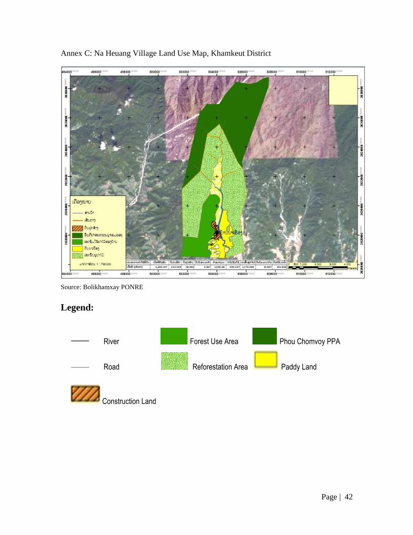
Annex C: Na Heuang Village Land Use Map, Khamkeut District
Source: Bolikhamxay PONRE
Legend:
River Forest Use Area Phou Chomvoy PPA
Road Reforestation Area Paddy Land
Construction Land
—
—

Page |
43
Annex D: Na Yang Land Use Map, Viengthong District
Source: Bolikhamxay PONRE
Legend:
Reserved agricultural land
River
Paddy Area
― Road
―
Na
National Protection
Forest
Construction
Land
Reforestation Area

Page |
44
Annex E: Na Tan Village Land Use Map, Viengthong District
Source: Bolikhamxay PONRE.
Legend:
River
―
―
School Area Construction Land
Reserved for agriculture land
Livestock grazing land
Reforestation area
Road

Page |
45
Annex F: Pha Bo Village Land Use Map, Viengthong District
Source: Bolikhamxay PONRE
Legend:
Village
boundaries
Village
location
Paddy land
Livestock grazing
land
Production expansion
area
Reforestation area
Page |
46
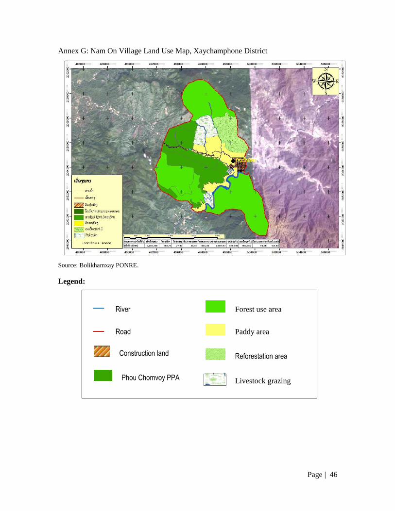
Annex G: Nam On Village Land Use Map, Xaychamphone District
Source: Bolikhamxay PONRE.
Legend:
―
―
River
Road
Construction land
Phou Chomvoy PPA
Forest use area
Paddy area
Reforestation area
Livestock grazing
land

Page |
47
Annex H: Phonkham Village Land Use Map, Xaychamphone District
Source: Bolikhamxay PONRE.
Legend:
―
―
River
Road
National Protection Forest
Production expansion area
Construction Land
Paddy area
Village conservation area
Livestock grazing land
Forest use area

Page |
48
Annex I: Vangban Village Land Use Map, Xaychamphone District
Source: Bolikhamxay PONRE
Legend:
―
―
River
Road
Construction land
Production land
Village Conservation Forest
National Protection Forest
Cemetery

Page |
49
REFERENCES
Department of Forestry. (2012). Report on the forest cover survey for 2010, Vientiane.
Department of Planning and Investment in Bolikhamxay. (2012). Summary of the
targeted priority data for the nine months of the socio-economic development plan
for 2011-2012 and the plan for 2012-2013 (in Lao). Bolikhamxay Province:
Report of the Statistical Division.
Duckworth, J. W., Salter, R. E., & Khounboline, K. (1999). Wildlife in Lao PDR: 1999
Status Report IUCN-The World Conservation Union/ Wildlife Conservation
Society / Centre for Protected Areas and Watershed Management, Vientiane.
Environment Protection Fund. (2013). Project completion report. Lao Environment and
Social (LENS) Project. Vol. 2 -Annexes. Final Report. Technical Report. .
Government of Lao PDR. (2005). Forestry Strategy to the Year 2020 of the Lao PDR.
Vientiane.
Heinimann, A. (2003). GIS based Watershed Classification in Lao PDR. Paper presented
at the First International Symposium on Southeast Asian Water Environment,
Asian Institute of Technology (AIT), Bangkok, Thailand.
Integrated Ecosystem and Wildlife Management Project. (2006). Significant wildlife and
wildlife habitats of the Bolikhamxay Province. Bolikhamxay Provincial
Agriculture and Forestry Office and Wildlife Conservation Society, Vientiane.
International Centre for Environmental Management. (2010). Theun-Hinboun Expansion
Hydropower Project-Review of ESIA. MK1 Report for Mekong CPWF.
Kyophilavong, P., & Tsechalicha, X. (2011). Sustainable financing mechanisms for
national protected area management in Lao PDR: Issues and options
(unpublished). Department of Forestry, Ministry of Agriculture and Forestry and
IUCN Lao PDR.
McWilliam, A. (2007). A preliminary biodiversity assessment North of the proposed
NG8 reservoir in Bolikhamxay Province. Wildlife Conservation Society,
Vientiane.
Ministry of Agriculture and Forestry, & Water Resources and Environment
Administration. (2010). Fourth national report to the Convention on Biological
Diversity (revised). Vientiane.
National Statistical Centre. (2007). Population and residence census 2005: Bolikhamxay
Province. Committee for Planning and Investment. Vientiane. .
Norplan A.S. (2008a). Section I: Environmental Impact Assessment.
Norplan A.S. (2008b). Section II: Environmental Management and Monitoring Plan.
Pangkham (2014). [Personal communication].
Pangxang, Y., Phoyduangsy, S., & Tsechalicha, X. (2014). Personal communication.
Provincial Department of Natural Resources and Environment of Bolikhamxay. (2014).
Information provided to the project 'Effective implementation of PES in Lao PDR'
(unpublished).
Robichaud, W. (2003). A reconnaissance of the Nam Chat-Nam Pan Provincial Protected
Area, Bolikhamxay Province, Lao PDR, Report to the International
Environmental and Social Panel of Experts for the Nam Theun 2 Hydroproject,
Vientiane.
Robichaud, W. (2014). [Personal Communication].

Page |
50
Robichaud, W., Marsh, C. W., Southammakoth, S., & Khounthikoummane, S. (2001).
Review of the National Protected Area System of Lao PDR, Lao-Swedish
Forestry Program / Division of Forest Resource Conservation, Department of
Forestry / IUCN - The World Conservation Union, Vientiane.
Scheufele, G., Bennett, J., Kragt, M., & Renten, M. (2014). Research Report 3:
Development of a ‘virtual’ PES scheme for the Nam Ngum River Basin.
Canberra: Crawford School of Public Policy, The Australian National University.
Scheufele, G., Smith, H., Tsechalicha, X., & Bennett, J. (2014). Research report 4: The
legal foundations of payments for environmental services in the Lao PDR.
Canberra: Crawford School of Public Policy, The Australian National University.
Social and Environmental Division. (2011). From Inception to 2010: Theun-Hin Boun
Power Project-THPC.
Social and Environmental Division. (2012). 2011 to Commercail Operations: Theun-Hin
Boun Power Project-THPC
Souriya, & Pangkham (2014). [Personal communication].
Southammakoth, S. T. (1999). The Protected Area System in Lao PDR: Country Status
Report - 1999. Paper presented at the Southeast Asia Regional Forum of the
World Commission on Protected Areas inPakse, Lao PDR. In Galt, A., Sigaty, T.
and Vinton, M. (Eds.). Vol.2 - Papers Presented. IUCN Lao PDR, Vientiane. pp.
45-54.
The National Agriculture and Forestry Research Institute, National University of Laos, &
Stichting Nederlandse Vrijwilligers. (2007). Non-timber forest products in the
Lao PDR. A manual of 100 commercial and traditional products. Vientiane.
Tizard, R. (1996). A Preliminary Wildlife and Habitat Survey ofthe Proposed Northern
Extension to the Nakai-Nam Theun National Biodiversity Conservation Area and
the Adjacent Nam Gnouang Area, Bolikhamsai Province, Lao PDR. Wildlife
Conservation Society. Vientiane.
Travers, H., Clements, T., & Hedemark, M. (2010). Developing a new model for
sustainable financing for conservation areas based on Payment for Ecosystem
Services (PES) in Bolikhamxay. Wildlife Conservation Society. Vientiane.
Vongkhamheng, C. (2014). [Personal communication].
Wildlife Conservation Society. (1995). A wildlife and habitat survey of the area to be
affected by the Theun-Hinboun hydropower project. Vientiane.
Wildlife Conservation Society. (2007). Plan for Catchment Protection and Rehabilitation
of the Theun Hinboun Expansion Project, Vientiane